

Majorcan cartographic school
Encyclopedia
Catalonia
Catalonia is an autonomous community in northeastern Spain, with the official status of a "nationality" of Spain. Catalonia comprises four provinces: Barcelona, Girona, Lleida, and Tarragona. Its capital and largest city is Barcelona. Catalonia covers an area of 32,114 km² and has an...
. The Majorcan school is frequently contrasted with the contemporary Italian cartography school.
Origins
The island of Majorca, the largest of the Balearic islandsBalearic Islands
The Balearic Islands are an archipelago of Spain in the western Mediterranean Sea, near the eastern coast of the Iberian Peninsula.The four largest islands are: Majorca, Minorca, Ibiza and Formentera. The archipelago forms an autonomous community and a province of Spain with Palma as the capital...
in the western Mediterranean, had a long history of seafaring. Their geographical knowledge was earned from their own experience and developed in a multicultural atmosphere. Muslim and Jewish merchants participated in extensive trade across the Mediterranean Sea with Italy
Italy
Italy , officially the Italian Republic languages]] under the European Charter for Regional or Minority Languages. In each of these, Italy's official name is as follows:;;;;;;;;), is a unitary parliamentary republic in South-Central Europe. To the north it borders France, Switzerland, Austria and...
, Egypt
Egypt
Egypt , officially the Arab Republic of Egypt, Arabic: , is a country mainly in North Africa, with the Sinai Peninsula forming a land bridge in Southwest Asia. Egypt is thus a transcontinental country, and a major power in Africa, the Mediterranean Basin, the Middle East and the Muslim world...
and Tunisia
Tunisia
Tunisia , officially the Tunisian RepublicThe long name of Tunisia in other languages used in the country is: , is the northernmost country in Africa. It is a Maghreb country and is bordered by Algeria to the west, Libya to the southeast, and the Mediterranean Sea to the north and east. Its area...
, and in the 14th century their commerce entered into the Atlantic, reaching as far as England
Kingdom of England
The Kingdom of England was, from 927 to 1707, a sovereign state to the northwest of continental Europe. At its height, the Kingdom of England spanned the southern two-thirds of the island of Great Britain and several smaller outlying islands; what today comprises the legal jurisdiction of England...
and the Low Countries
Low Countries
The Low Countries are the historical lands around the low-lying delta of the Rhine, Scheldt, and Meuse rivers, including the modern countries of Belgium, the Netherlands, Luxembourg and parts of northern France and western Germany....
. Ruled as an independent Musim kingdom through much of the Early Middle Ages, Majorca only came under Christian rule in 1231, albeit retaining its independence as the Kingdom of Majorca
Kingdom of Majorca
The Kingdom of Majorca was founded by James I of Aragon, also known as James The Conqueror. After the death of his first-born son Alfonso, a will was written in 1262 which created the kingdom in order to cede it to his son James...
until 1344, when it was permanently annexed to the Crown of Aragon
Crown of Aragon
The Crown of Aragon Corona d'Aragón Corona d'Aragó Corona Aragonum controlling a large portion of the present-day eastern Spain and southeastern France, as well as some of the major islands and mainland possessions stretching across the Mediterranean as far as Greece...
. This coincided with a period of Aragonese expansionism across the Mediterranean to Sardinia and Corsica
Kingdom of Sardinia and Corsica
The Kingdom of Sardinia and Corsica was a constituent country of several States through six centuries...
, Sicily
Kingdom of Sicily
The Kingdom of Sicily was a state that existed in the south of Italy from its founding by Roger II in 1130 until 1816. It was a successor state of the County of Sicily, which had been founded in 1071 during the Norman conquest of southern Italy...
and Greece (Athens
Duchy of Athens
The Duchy of Athens was one of the Crusader States set up in Greece after the conquest of the Byzantine Empire during the Fourth Crusade, encompassing the regions of Attica and Boeotia, and surviving until its conquest by the Ottoman Empire in the 15th century....
and Neopatria
Duchy of Neopatria
The Duchy of Neopatria or Neopatras was one of the Crusader States set up in Greece after the conquest of the Byzantine Empire during the Fourth Crusade...
), in which Majorcan nautical, cartographic and mercantile expertise was often called upon. Majorcan merchants and seafarers spearheaded the attempt by the Aragonese crown to seize the newly-discovered Canary Islands in the Atlantic from the 1340s to the 1360s.
With their multicultural heritage unencumbered by rigid academic Christian traditions, Majorcan cosmographers and cartographers experimented and developed their own cartographic techniques. According to some scholars (e.g. Nordenskiold), the Majorcans were responsible for the invention (c.1300) of the "normal portolan chart
Portolan chart
Portolan charts are navigational maps based on realistic descriptions of harbours and coasts. They were first made in the 14th century in Italy, Portugal and Spain...
". The portolan was a realistic, detailed nautical chart, gridded by compass
Compass
A compass is a navigational instrument that shows directions in a frame of reference that is stationary relative to the surface of the earth. The frame of reference defines the four cardinal directions – north, south, east, and west. Intermediate directions are also defined...
lines, that could be used to deduce exact sailing directions between any two points.
Portolan charts, which appeared rather suddenly after 1300, constitute a sharp departure from all earlier maps. Unlike the circular mappa mundi
Mappa mundi
Mappa mundi is a general term used to describe medieval European maps of the world. These maps range in size and complexity from simple schematic maps an inch or less across to elaborate wall maps, the largest of which was 11 ft. in diameter...
of Christian academic tradition, the portolan was oriented towards the north, and focused on a realistic depiction of geographic distances with a degree of accuracy that is astounding, even by modern standards. Historians conjecture the portolan was constructed from the first-hand informtion of mariners and merchants, possibly assisted by astronomers, and were geared for navigational use, in particular the plotting by compass of navigational routes.
Both Majorca and Genoa
Genoa
Genoa |Ligurian]] Zena ; Latin and, archaically, English Genua) is a city and an important seaport in northern Italy, the capital of the Province of Genoa and of the region of Liguria....
have laid claim for the invention of the portolan chart, and it is unlikely this will ever be resolved. Few charts have survived to the modern day. The earliest extant ones, from the first half of the 14th C., seem to have been constructed by Genoese cartographers, with Majorcan charts making their appearance only in the latter half of the century. As a result, many historians have argued that the Majorcan cartography derived from the Genoese, citing the mysterious figure of Angelino Dulcert
Angelino Dulcert
Angelino Dulcert , probably also the same person known as Angelino de Dalorto , and who's real name was probably Angelino de Dulceto or Dulceti or possibly Angelí Dolcet, was an Italian-Majorcan cartographer....
, possibly a Genoese immigrant working in Majorca in the 1330s, as the key intermediary in the transmission. On the other hand, some scholars have embraced the hypothesis first forwarded by A.E. Nordenskiöld
Adolf Erik Nordenskiöld
Freiherr Nils Adolf Erik Nordenskiöld , also known as A. E. Nordenskioeld was a Finnish baron, geologist, mineralogist and arctic explorer of Finnish-Swedish origin. He was a member of the prominent Finland-Swedish Nordenskiöld family of scientists...
, that the surviving charts are misleading, that the earliest Genoese maps were just faithful copies of a conjectured prototype (now lost), composed around 1300 by an unknown Majorcan cosmographer, possibly with the involvement of Ramon Llull
Ramon Llull
Ramon Llull was a Majorcan writer and philosopher, logician and tertiary Franciscan. He wrote the first major work of Catalan literature. Recently-surfaced manuscripts show him to have anticipated by several centuries prominent work on elections theory...
. An intermediary position acknowledges Genoese priority, but insists the Majorcan school had an autonomous origin, at best "inspired" (but not derived) from the Genoese. Recent research tends to lean towards the first interpretation, but at the same time curbing some of the more extreme Italian claims and recognizing distinctively Majorcan development.
Majorcan Style
Regardless of the exact origin, historians agree that the Majorcans developed their own distinctive style or "school" of portolan cartography, which can be distinguished from the "Italian school". Both Italian and Majorcan portolan charts focus on the same geographic area, what is sometimes called the "Normal Portolan": the Mediterranean SeaMediterranean Sea
The Mediterranean Sea is a sea connected to the Atlantic Ocean surrounded by the Mediterranean region and almost completely enclosed by land: on the north by Anatolia and Europe, on the south by North Africa, and on the east by the Levant...
, the Black Sea
Black Sea
The Black Sea is bounded by Europe, Anatolia and the Caucasus and is ultimately connected to the Atlantic Ocean via the Mediterranean and the Aegean seas and various straits. The Bosphorus strait connects it to the Sea of Marmara, and the strait of the Dardanelles connects that sea to the Aegean...
and the Atlantic Ocean
Atlantic Ocean
The Atlantic Ocean is the second-largest of the world's oceanic divisions. With a total area of about , it covers approximately 20% of the Earth's surface and about 26% of its water surface area...
coast up to the environs of Flanders
Flanders
Flanders is the community of the Flemings but also one of the institutions in Belgium, and a geographical region located in parts of present-day Belgium, France and the Netherlands. "Flanders" can also refer to the northern part of Belgium that contains Brussels, Bruges, Ghent and Antwerp...
- in short, the area frequently travelled by contemporary Mediterranean merchants and sailors. As time and knowledge progressed, some cartographers would stretch the geographic boundaries of the normal portolan to include a larger swathe of Atlantic ocean, including many Atlantic islands (real and mythical), a longer stretch of the west Africa
West Africa
West Africa or Western Africa is the westernmost region of the African continent. Geopolitically, the UN definition of Western Africa includes the following 16 countries and an area of approximately 5 million square km:-Flags of West Africa:...
n coast to the south, the Baltic Sea
Baltic Sea
The Baltic Sea is a brackish mediterranean sea located in Northern Europe, from 53°N to 66°N latitude and from 20°E to 26°E longitude. It is bounded by the Scandinavian Peninsula, the mainland of Europe, and the Danish islands. It drains into the Kattegat by way of the Øresund, the Great Belt and...
in the north and the Caspian Sea
Caspian Sea
The Caspian Sea is the largest enclosed body of water on Earth by area, variously classed as the world's largest lake or a full-fledged sea. The sea has a surface area of and a volume of...
in the east. Nonetheless, the central focus on the Mediterranean remained throughout and the scale rarely changed.
The distinction between the Majorcan and Italian school is one of style rather than range. Italian portolan charts were sparse and restrained, strictly focused on coastal detail, with the inland areas left largely or wholly empty, and the charts largely bereft of illustrations.
The Majorcan style, its beginnings already decipherable in the 1339 chart of Angelino Dulcert
Angelino Dulcert
Angelino Dulcert , probably also the same person known as Angelino de Dalorto , and who's real name was probably Angelino de Dulceto or Dulceti or possibly Angelí Dolcet, was an Italian-Majorcan cartographer....
, and finding its epitome in the Catalan Atlas
Catalan Atlas
The Catalan Atlas is the most important Catalan map of the medieval period. It was produced by the Majorcan cartographic school and is attributed to Cresques Abraham , a Jewish book illuminator who was self-described as being a master of the maps of the world as well as compasses...
of 1375 (attributed to Majorcan cartographer Abraham Cresques
Abraham Cresques
Abraham Cresques , whose real name was probably Cresques Abraham, was a 14th-century Jewish cartographer from Palma, Majorca...
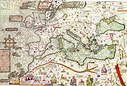
), contained a lot more inland detail and was replete with rich colorful illustrations, depicting cities, mountain ranges, rivers and some miniature people. Among the quintessential features replicated in almost all Majorcan charts:
- scattered notes and labels in CatalanCatalan languageCatalan is a Romance language, the national and only official language of Andorra and a co-official language in the Spanish autonomous communities of Catalonia, the Balearic Islands and Valencian Community, where it is known as Valencian , as well as in the city of Alghero, on the Italian island...
- the Red SeaRed SeaThe Red Sea is a seawater inlet of the Indian Ocean, lying between Africa and Asia. The connection to the ocean is in the south through the Bab el Mandeb strait and the Gulf of Aden. In the north, there is the Sinai Peninsula, the Gulf of Aqaba, and the Gulf of Suez...
painted red - the Atlas MountainsAtlas MountainsThe Atlas Mountains is a mountain range across a northern stretch of Africa extending about through Morocco, Algeria, and Tunisia. The highest peak is Toubkal, with an elevation of in southwestern Morocco. The Atlas ranges separate the Mediterranean and Atlantic coastlines from the Sahara Desert...
depicted as a palm tree - the AlpsAlpsThe Alps is one of the great mountain range systems of Europe, stretching from Austria and Slovenia in the east through Italy, Switzerland, Liechtenstein and Germany to France in the west....
as a chicken's foot - the TagusTagusThe Tagus is the longest river on the Iberian Peninsula. It is long, in Spain, along the border between Portugal and Spain and in Portugal, where it empties into the Atlantic Ocean at Lisbon. It drains an area of . The Tagus is highly utilized for most of its course...
as a shepherd's crook, with the curve wrapping around ToledoToledo- Places :Belize:*Toledo District*Toledo SettlementBrazil:*Pedro de Toledo, São Paulo*Toledo, ParanáColombia:*Toledo, Norte de SantanderPhilippines:*Toledo City, CebuSpain:*Toledo, Spain *Kingdom of Toledo...
. - the DanubeDanubeThe Danube is a river in the Central Europe and the Europe's second longest river after the Volga. It is classified as an international waterway....
as a chain of links or hillocks. - BohemiaBohemiaBohemia is a historical region in central Europe, occupying the western two-thirds of the traditional Czech Lands. It is located in the contemporary Czech Republic with its capital in Prague...
as a horseshoe - the Canary island of LanzaroteLanzaroteLanzarote , a Spanish island, is the easternmost of the autonomous Canary Islands, in the Atlantic Ocean, approximately 125 km off the coast of Africa and 1,000 km from the Iberian Peninsula. Covering 845.9 km2, it stands as the fourth largest of the islands...
colored with a Genoese shield (red cross on white). - the island of RhodesRhodesRhodes is an island in Greece, located in the eastern Aegean Sea. It is the largest of the Dodecanese islands in terms of both land area and population, with a population of 117,007, and also the island group's historical capital. Administratively the island forms a separate municipality within...
also colored with a shield with a cross. - the striped shield of the Crown of AragonCrown of AragonThe Crown of Aragon Corona d'Aragón Corona d'Aragó Corona Aragonum controlling a large portion of the present-day eastern Spain and southeastern France, as well as some of the major islands and mainland possessions stretching across the Mediterranean as far as Greece...
replicated as often as possible, including covering the island of Majorca itself. - a compass roseCompass roseA compass rose, sometimes called a windrose, is a figure on a compass, map, nautical chart or monument used to display the orientation of the cardinal directions — North, East, South and West - and their intermediate points. It is also the term for the graduated markings found on the traditional...
somewhere on the map, with the Pole StarPole starThe term "Pole Star" usually refers to Polaris, which is the current northern pole star, also known as the North Star.In general, however, a pole star is a visible star, especially a prominent one, that is approximately aligned with the Earth's axis of rotation; that is, a star whose apparent...
set on the north.
Among the miniature people routinely found in many Majorcan maps are depictions of the traders on the Silk Road
Silk Road
The Silk Road or Silk Route refers to a historical network of interlinking trade routes across the Afro-Eurasian landmass that connected East, South, and Western Asia with the Mediterranean and European world, as well as parts of North and East Africa...
and the trans-Saharan route
Trans-Saharan trade
Trans-Saharan trade requires travel across the Sahara to reach sub-Saharan Africa. While existing from prehistoric times, the peak of trade extended from the 8th century until the late 16th century.- Increasing desertification and economic incentive :...
, the Emperor
Mansa
Mansa is a Mandinka word meaning "king of kings". It is particularly associated with the Keita Dynasty of the Mali Empire, which dominated West Africa from the thirteenth to the fifthteenth century...
of Mali
Mali Empire
The Mali Empire or Mandingo Empire or Manden Kurufa was a West African empire of the Mandinka from c. 1230 to c. 1600. The empire was founded by Sundiata Keita and became renowned for the wealth of its rulers, especially Mansa Musa I...
seated on a gold mine and the ship of Jaume Ferrer
Jaume Ferrer
Jaume Ferrer was a Majorcan sailor and explorer.Practically nothing is known of Jaume Ferrer, save that he was a Majorcan captain, who set out in a galley in 1346, and sailed down the West African coast in an attempt to reach the legendary "River of Gold". The results of this expedition, including...
.
Although the Italian school largely adhered to its sparse style, some later Italian cartographers, such as the Pizzigani brothers and Battista Beccario
Battista Beccario
Battista Beccario, also known as Baptista Beccharius , was a 15th Century Genoese cartographer.Virtually nothing is known of his life...
toyed with Majorcan themes, and introduced some of their features into their own maps.
Although some historians like to distinguish the Italian maps as "nautical" and the Majorcan maps as "nautico-geographic", it is important to note that the Majorcan portolans did not sacrifice the essential nautical function of their portolans. Lift the garish illustrations, and the Majorcan maps are as nautically detailed and serviceable as the Italian.
Members
Major members of the Majorcan school of cartography include:- Angelino DulcertAngelino DulcertAngelino Dulcert , probably also the same person known as Angelino de Dalorto , and who's real name was probably Angelino de Dulceto or Dulceti or possibly Angelí Dolcet, was an Italian-Majorcan cartographer....
(fl. 1339) - possibly a Genoese immigrant. - Abraham CresquesAbraham CresquesAbraham Cresques , whose real name was probably Cresques Abraham, was a 14th-century Jewish cartographer from Palma, Majorca...
(fl. 1375) - Jehuda CresquesJehuda CresquesJehuda Cresques , also known as Jafudà Cresques, Jaume Riba, and Cresques lo Juheu was a Catalan cartographer, and was once believed to be the man who coordinated the discoveries of the Portuguese naval school at Sagres in the early 15th century.Son of Abraham Cresques, a famous Jewish...
("Jaume Riba"/"Jacobus Ribes") - Haym ibn Risch ("Joan de Vallsecha")
- Guillem SolerGuillem SolerGuillem Soler , sometimes given as Guillelmus Soleri, Guillermo Soler and Guglielmo Soleri, was a Majorcan cartographer of the 15th C....
(fl. 1380s) - Mecia de Viladestes (fl. 1410s)
- Jacomé of Majorca (1420s?) - moved to Portugal
- Gabriel de VallsecaGabriel de VallsecaGabriel de Vallseca, also referred to as Gabriel de Valseca and Gabriel de Valsequa was a Catalan cartographer of Jewish descent connected to the Majorcan cartographic school...
(fl.1430s-40s) - Pere Rosell (fl.1460s)
- Jaume Bertran (fl. 1480s).
Unlike in Italy, where the crafts of instrument-making and cartography were distinct, most of the Majorcan cartographers also worked as makers of nautical instruments - often appearing in civic records, as both master map-maker and bruixoler ("compass-maker"). Some were also amateur or professional cosmographers, with expertise in astrology
Astrology
Astrology consists of a number of belief systems which hold that there is a relationship between astronomical phenomena and events in the human world...
and astronomy
Astronomy
Astronomy is a natural science that deals with the study of celestial objects and phenomena that originate outside the atmosphere of Earth...
, frequently inserting astronomical calendar
Calendar
A calendar is a system of organizing days for social, religious, commercial, or administrative purposes. This is done by giving names to periods of time, typically days, weeks, months, and years. The name given to each day is known as a date. Periods in a calendar are usually, though not...
s in their atlases.
Most members of the Majorcan school (with the exception of Soler) were Jews
Jews
The Jews , also known as the Jewish people, are a nation and ethnoreligious group originating in the Israelites or Hebrews of the Ancient Near East. The Jewish ethnicity, nationality, and religion are strongly interrelated, as Judaism is the traditional faith of the Jewish nation...
, whether practicing or conversos. As a result, the school suffered heavily and eventually expired with the extension of force-conversion, expulsions and the Spanish Inquisition
Spanish Inquisition
The Tribunal of the Holy Office of the Inquisition , commonly known as the Spanish Inquisition , was a tribunal established in 1480 by Catholic Monarchs Ferdinand II of Aragon and Isabella I of Castile. It was intended to maintain Catholic orthodoxy in their kingdoms, and to replace the Medieval...
into the realms of the Crown of Aragon in the late 15th C.
The production of medieval Portolan chart
Portolan chart
Portolan charts are navigational maps based on realistic descriptions of harbours and coasts. They were first made in the 14th century in Italy, Portugal and Spain...
s can be divided in two major schools: the Italian
Italy
Italy , officially the Italian Republic languages]] under the European Charter for Regional or Minority Languages. In each of these, Italy's official name is as follows:;;;;;;;;), is a unitary parliamentary republic in South-Central Europe. To the north it borders France, Switzerland, Austria and...
and the Catalan. Italian medieval cartographers came mostly from Genoa
Genoa
Genoa |Ligurian]] Zena ; Latin and, archaically, English Genua) is a city and an important seaport in northern Italy, the capital of the Province of Genoa and of the region of Liguria....
and Venice
Venice
Venice is a city in northern Italy which is renowned for the beauty of its setting, its architecture and its artworks. It is the capital of the Veneto region...
. Catalan charts were made in Majorca and Barcelona
Barcelona
Barcelona is the second largest city in Spain after Madrid, and the capital of Catalonia, with a population of 1,621,537 within its administrative limits on a land area of...
. Beside these two major schools, some maps were made in Portugal
Portugal
Portugal , officially the Portuguese Republic is a country situated in southwestern Europe on the Iberian Peninsula. Portugal is the westernmost country of Europe, and is bordered by the Atlantic Ocean to the West and South and by Spain to the North and East. The Atlantic archipelagos of the...
, but no examples survive.
The inhabitants of Majorca were great navigators and cartographers. Their geographical knowledge was earned from their own experience and developed in a multicultural atmosphere. Muslim and Jewish merchants participated in extensive trade with Egypt and Tunisia, and in the 14th century they started doing business with England
England
England is a country that is part of the United Kingdom. It shares land borders with Scotland to the north and Wales to the west; the Irish Sea is to the north west, the Celtic Sea to the south west, with the North Sea to the east and the English Channel to the south separating it from continental...
and Netherlands
Netherlands
The Netherlands is a constituent country of the Kingdom of the Netherlands, located mainly in North-West Europe and with several islands in the Caribbean. Mainland Netherlands borders the North Sea to the north and west, Belgium to the south, and Germany to the east, and shares maritime borders...
. These groups were not limited by the rules imposed by the Christian framework, and their maps were way ahead of their time. Professor Gerald Crone, who wrote books on medieval mapping, said of these cartographers, they "...threw off the bounds of tradition and anticipated the achievements of the Renaissance". The maps they made were prized by the princes and rulers of the Spanish mainland and other countries. The maps made in Majorca were easy to recognize by their brightly colored illustrations of significant geographical features and portraits of foreign rulers.
The first known Majorcan map was made by Angelino Dulcert
Angelino Dulcert
Angelino Dulcert , probably also the same person known as Angelino de Dalorto , and who's real name was probably Angelino de Dulceto or Dulceti or possibly Angelí Dolcet, was an Italian-Majorcan cartographer....
in 1339. Even in this early work, all the distinguishing features of the Majorcan Cartographic School were present. Dulcert made precise, colorful drawings that showed all the topographical details including rivers, lakes, mountains, etc. The notes written in Latin
Latin
Latin is an Italic language originally spoken in Latium and Ancient Rome. It, along with most European languages, is a descendant of the ancient Proto-Indo-European language. Although it is considered a dead language, a number of scholars and members of the Christian clergy speak it fluently, and...
described the map.
The most famous cartographers from the Majorcan school were Jews.
Catalan Atlas and Abraham and Jehuda Cresques
Abraham CresquesAbraham Cresques
Abraham Cresques , whose real name was probably Cresques Abraham, was a 14th-century Jewish cartographer from Palma, Majorca...
also known as, Cresques the Jew, was appointed as a Master of Maps and Compass
Compass
A compass is a navigational instrument that shows directions in a frame of reference that is stationary relative to the surface of the earth. The frame of reference defines the four cardinal directions – north, south, east, and west. Intermediate directions are also defined...
es by John I of Aragon
John I of Aragon
John I , called by posterity the Hunter or the Lover of Elegance , but the Abandoned in his lifetime, was the King of...
. The money he got for his appointment was used to build baths for Jews in Palma.
In 1374 and 1375 Abraham and his son Jehuda
Jehuda Cresques
Jehuda Cresques , also known as Jafudà Cresques, Jaume Riba, and Cresques lo Juheu was a Catalan cartographer, and was once believed to be the man who coordinated the discoveries of the Portuguese naval school at Sagres in the early 15th century.Son of Abraham Cresques, a famous Jewish...
worked on a special order.
John I of Aragon advised the authorities that he needed to get a map, which would show the Strait of Gibraltar
Strait of Gibraltar
The Strait of Gibraltar is a narrow strait that connects the Atlantic Ocean to the Mediterranean Sea and separates Spain in Europe from Morocco in Africa. The name comes from Gibraltar, which in turn originates from the Arabic Jebel Tariq , albeit the Arab name for the Strait is Bab el-Zakat or...
, the Atlantic coast and the ocean itself. The map they made got the name Catalan Atlas
Catalan Atlas
The Catalan Atlas is the most important Catalan map of the medieval period. It was produced by the Majorcan cartographic school and is attributed to Cresques Abraham , a Jewish book illuminator who was self-described as being a master of the maps of the world as well as compasses...
, and it is the most important Catalan
Catalan language
Catalan is a Romance language, the national and only official language of Andorra and a co-official language in the Spanish autonomous communities of Catalonia, the Balearic Islands and Valencian Community, where it is known as Valencian , as well as in the city of Alghero, on the Italian island...
map of the medieval period.
The first two leaves, forming the oriental portion of the Catalan Atlas, illustrate numerous religious references as well as a synthesis of medieval mappae mundi (Jerusalem located close to the center) and the travel literature of the time, notably Marco Polo
Marco Polo
Marco Polo was a Venetian merchant traveler from the Venetian Republic whose travels are recorded in Il Milione, a book which did much to introduce Europeans to Central Asia and China. He learned about trading whilst his father and uncle, Niccolò and Maffeo, travelled through Asia and apparently...
's Book of Marvels and the Travels
The Travels of Marco Polo
Books of the Marvels of the World or Description of the World , also nicknamed Il Milione or Oriente Poliano and commonly called The Travels of Marco Polo, is a 13th-century travelogue written down by Rustichello da Pisa from stories told by Marco Polo, describing the...
, and Voyage of Sir John Mandeville. Many Indian and Chinese cities can be identified. The explanatory texts report customs described by Marco Polo
Marco Polo
Marco Polo was a Venetian merchant traveler from the Venetian Republic whose travels are recorded in Il Milione, a book which did much to introduce Europeans to Central Asia and China. He learned about trading whilst his father and uncle, Niccolò and Maffeo, travelled through Asia and apparently...
. Cresques, who knew Arabic, also used the travel narratives of Moroccan explorer Ibn Battuta
Ibn Battuta
Abu Abdullah Muhammad Ibn Battuta , or simply Ibn Battuta, also known as Shams ad–Din , was a Muslim Moroccan Berber explorer, known for his extensive travels published in the Rihla...
. Mecca
Mecca
Mecca is a city in the Hijaz and the capital of Makkah province in Saudi Arabia. The city is located inland from Jeddah in a narrow valley at a height of above sea level...
has a blue dome and shows Muslim prayer. The text next to the image is:
While the areas under Muslim control were marked with domes, Jerusalem was surrounded by tales from Old and New Testaments like the Garden of Eden
Garden of Eden
The Garden of Eden is in the Bible's Book of Genesis as being the place where the first man, Adam, and his wife, Eve, lived after they were created by God. Literally, the Bible speaks about a garden in Eden...
, the crucifixion
Crucifixion
Crucifixion is an ancient method of painful execution in which the condemned person is tied or nailed to a large wooden cross and left to hang until dead...
, Noah's Ark
Noah's Ark
Noah's Ark is a vessel appearing in the Book of Genesis and the Quran . These narratives describe the construction of the ark by Noah at God's command to save himself, his family, and the world's animals from the worldwide deluge of the Great Flood.In the narrative of the ark, God sees the...
and others.
The image of the caravan is accompanied by Marco Polo's travel account:
A Catalan Atlas was requested by Charles VI of France
Charles VI of France
Charles VI , called the Beloved and the Mad , was the King of France from 1380 to 1422, as a member of the House of Valois. His bouts with madness, which seem to have begun in 1392, led to quarrels among the French royal family, which were exploited by the neighbouring powers of England and Burgundy...
, even though he expelled all the Jews from France in 1394.
The Catalan Atlas is located now in Bibliothèque nationale de France
Bibliothèque nationale de France
The is the National Library of France, located in Paris. It is intended to be the repository of all that is published in France. The current president of the library is Bruno Racine.-History:...
. A few other Cresques maps were mentioned in inventories from Spain and France in late 1387.
Jehuda Cresques continued his father's traditions. He was forced to convert to Christianity in 1391. His new name was Jacobus Ribes. He was called "lo Juen buscoler" (the map Jew), or "el jueu de les bruixoles" (the compass Jew). Jehuda was ordered to move to Barcelona, where he continued his work, as a court cartographer. Later, he was invited to Portugal by Henry the Navigator, but his maps were still made in Catalan (Majorca) traditions, and that's why he was called "Mestre Jacome de Malhorca". He was the first director of famous Nautical observatory at Sagres
Sagres, Portugal
Sagres is a town located in the municipality of Vila do Bispo, Algarve, Portugal. It has a surface of 34,28 km² and a population of 1 939 . Sagres Point, historically connected to the Portuguese Age of Discovery, is located there....
at the age of discovery.
Other Jewish cartographers
Another famous Jewish cartographer was Haym ibn Risch. He was forced to convert to Christianity and took the name Juan de Vallsecha. He was probably the father of Gabriel Vallsecha, author of yet another famous mapamundi, one later used by Amerigo VespucciAmerigo Vespucci
Amerigo Vespucci was an Italian explorer, financier, navigator and cartographer. The Americas are generally believed to have derived their name from the feminized Latin version of his first name.-Expeditions:...
. Gabriel also produced a very accurate maps of Black Sea
Black Sea
The Black Sea is bounded by Europe, Anatolia and the Caucasus and is ultimately connected to the Atlantic Ocean via the Mediterranean and the Aegean seas and various straits. The Bosphorus strait connects it to the Sea of Marmara, and the strait of the Dardanelles connects that sea to the Aegean...
and Mediterranean Sea
Mediterranean Sea
The Mediterranean Sea is a sea connected to the Atlantic Ocean surrounded by the Mediterranean region and almost completely enclosed by land: on the north by Anatolia and Europe, on the south by North Africa, and on the east by the Levant...
. Another Jewish cartographer was Mecia de Vildestes. An outstanding map by Vildestes dated 1413 is proudly featured at the Bibliothèque Nationale of Paris.
Anti-Jewish persecutions brought the end to the famous school of cartography at Majorca.
Chronology of Majorcan cartographers
(Timeline derived from :ca:Llista cronològica de cartògrafs portolans mallorquins)See also
- Abraham CresquesAbraham CresquesAbraham Cresques , whose real name was probably Cresques Abraham, was a 14th-century Jewish cartographer from Palma, Majorca...
- Catalan AtlasCatalan AtlasThe Catalan Atlas is the most important Catalan map of the medieval period. It was produced by the Majorcan cartographic school and is attributed to Cresques Abraham , a Jewish book illuminator who was self-described as being a master of the maps of the world as well as compasses...
- www.cresquesproject.net --Translation in English of the works of Riera i Sans and Gabriel Llompart on the Jewish Majorcan Map-makers of the Late Middle Ages
Sources
- Campbell, T. (1987) "Portolan Charts from the Late Thirteenth Century to 1500". The History of Cartography. Volume 1. Chicago: University of Chicago Press, pp. 371-463.
- Campbell, T. (2011) "A critical re-examination of early portolan charts with a reassessment of their replication and seaboard function" (online)
- Caraci, G. (1959) Italiani e Catalani nella primitiva cartografia medievale, Rome: 'Universita degli studi.
- Magnaghi, A. (1909) "Sulle origini del portolano normale nel Medio Evo e della Cartografia dell'Europa occidentale", in Memorie geografiche, vol. 4, no.8, p.115-80.
- Nordenskiöld, Adolf Erik (1896) "Résumé of an Essay on the Early History of Charts and Sailing Directions", Report of the Sixth International Geographical Congress: held in London, 1895. London: J. Murrayp.685-94
- Nordenskiöld, Adolf Erik (1897) Periplus: An Essay on the Early History of Charts and Sailing Directions, tr. Frances A. Bather, Stockholm: Norstedt.
- Pujades i Bataller, Ramon J. (2007) Les cartes portolanes: la representació medieval d'una mar solcada. Barcelona
- Heinrich Winter (1947) "On the Real and the Pseudo-Pilestrina Maps and Other Early Portuguese Maps in Munich", Imago Mundi, vol. 4,p.25-27.
- Winter, Heinrich (1958) "Catalan Portolan Maps and their place in the total view of cartographic development", Imago Mundi, Vol.11, p.1-12