
Maidenhead Locator System
Encyclopedia
The Maidenhead Locator System is a geographic coordinate system
used by amateur radio
operators. Dr. John Morris, G4ANB, originally devised the system, and a group of VHF managers, meeting in Maidenhead
, England
in 1980, adopted it. The Maidenhead Locator System supplants the older QRA locator system with one that is usable outside of Europe
.
Maidenhead locators are also commonly referred to as grid locators or grid squares, despite having a non-square shape on any non-equirectangular
cartographic projection.
 A Maidenhead locator compresses latitude
and longitude
into a short string of characters. This position information is presented in a limited level of precision in order to limit the amount of characters needed for its transmission using voice, Morse code
, or any other operating mode.
The chosen coding uses alternating pairs of letters and digits, like so:
In each pair, the first character encodes longitude and the second character encodes latitude. These character pairs also have traditional names, and in the case of letters, the range of characters (or "encoding base number") used in each pair does vary.
In order to avoid negative numbers in the input data, the system also specifies that latitude is measured from the South Pole
to the North Pole
, and longitude measured eastward from the antimeridian of Greenwich
, giving the Prime Meridian
a false easting
of 180° and the equator
a false northing
of 90°.
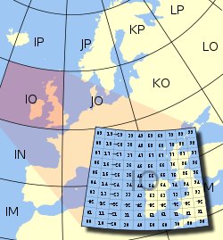
To simplify manual encoding, the base for the first pair of letters—traditionally called a field—was chosen to be 18, thus dividing the globe into 18 zones of longitude of 20° each, and 18 zones of latitude 10° each. These zones are encoded with the letters "A" through "R".
The first pair of numbers, called a square and placed after the first pair of letters, uses a base number of 10, and is encoded using the digits "0" to "9". This is where the alternative name "grid squares" comes from. Each of these squares represents 1° of latitude by 2° of longitude.
For additional precision, each square can optionally be sub-divided further, into subsquares. These are encoded into a second pair of letters, often (but not always) presented in lowercase, and again, to make manual calculations from degrees and minutes easier, 24 was chosen as the base number, giving these subsquares dimensions of 2.5' of latitude by 5' of longitude. The letters used are "A" through "X".
The resulting Maidenhead subsquare locator string is hence composed of two letters, two digits, and two more letters. To give an example, W1AW, the American Radio Relay League's
Hiram Percy Maxim
Memorial Station in Newington, Connecticut
, is found in grid locator . Two points within the same Maidenhead subsquare are always less than 12 km apart, which means a Maidenhead locator can give significant precision from just six easily transmissible characters.
 For even more precise location mapping, two additional digits were proposed and ratified as an extended locator, making it altogether eight characters long, and dividing subsquares into even smaller ones. Such precision has uses in very short communication spans. Beyond this, no common definition exists to extend the system further into even smaller squares. Most often the extending is done by repeating alternating subsquare and square rules (base numbers 24 and 10 respectively). However, other bases for letter encodings have also been observed, and therefore such extended extended locators might not be compatible.
The Maidenhead locator system has been explicitly based on the WGS 84 geodetic datum since 1999. Before that time, it was usually based on each user's local national datum, which do differ slightly from one another and WGS 84. As a result, stations very near the edges of squares at denoted precision may have changed their locators when changing over to the use of WGS 84.
To summarize:
On shortwave
frequencies, positions are reported at square precision, and on VHF and UHF, subsquare precision is used. More precise position reports are very rarely used.
receivers are frequently able to display Maidenhead locators.
Maidenhead locators are used as part of the formulas for scoring in many VHF amateur radio contests
. Grid locators are also the basis of earning many awards like the American Radio Relay League's VHF/UHF Century Club
, URE TTLOC, etc. operating award.
In IARU Region 1 rules, VHF distance calculations are carried out between Maidenhead subsquare centers assuming a spherical Earth. This results in a small error in distance, but makes calculations simpler and, given the inherent imprecision in the used input data, it is not the biggest error source.
Geographic coordinate system
A geographic coordinate system is a coordinate system that enables every location on the Earth to be specified by a set of numbers. The coordinates are often chosen such that one of the numbers represent vertical position, and two or three of the numbers represent horizontal position...
used by amateur radio
Amateur radio
Amateur radio is the use of designated radio frequency spectrum for purposes of private recreation, non-commercial exchange of messages, wireless experimentation, self-training, and emergency communication...
operators. Dr. John Morris, G4ANB, originally devised the system, and a group of VHF managers, meeting in Maidenhead
Maidenhead
Maidenhead is a town and unparished area within the Royal Borough of Windsor and Maidenhead, in Berkshire, England. It lies on the River Thames and is situated west of Charing Cross in London.-History:...
, England
England
England is a country that is part of the United Kingdom. It shares land borders with Scotland to the north and Wales to the west; the Irish Sea is to the north west, the Celtic Sea to the south west, with the North Sea to the east and the English Channel to the south separating it from continental...
in 1980, adopted it. The Maidenhead Locator System supplants the older QRA locator system with one that is usable outside of Europe
Europe
Europe is, by convention, one of the world's seven continents. Comprising the westernmost peninsula of Eurasia, Europe is generally 'divided' from Asia to its east by the watershed divides of the Ural and Caucasus Mountains, the Ural River, the Caspian and Black Seas, and the waterways connecting...
.
Maidenhead locators are also commonly referred to as grid locators or grid squares, despite having a non-square shape on any non-equirectangular
Equirectangular projection
The equirectangular projection is a very simple map projection attributed to Marinus of Tyre, who Ptolemy claims invented the projection about AD 100...
cartographic projection.
Description of the system
Latitude
In geography, the latitude of a location on the Earth is the angular distance of that location south or north of the Equator. The latitude is an angle, and is usually measured in degrees . The equator has a latitude of 0°, the North pole has a latitude of 90° north , and the South pole has a...
and longitude
Longitude
Longitude is a geographic coordinate that specifies the east-west position of a point on the Earth's surface. It is an angular measurement, usually expressed in degrees, minutes and seconds, and denoted by the Greek letter lambda ....
into a short string of characters. This position information is presented in a limited level of precision in order to limit the amount of characters needed for its transmission using voice, Morse code
Morse code
Morse code is a method of transmitting textual information as a series of on-off tones, lights, or clicks that can be directly understood by a skilled listener or observer without special equipment...
, or any other operating mode.
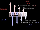
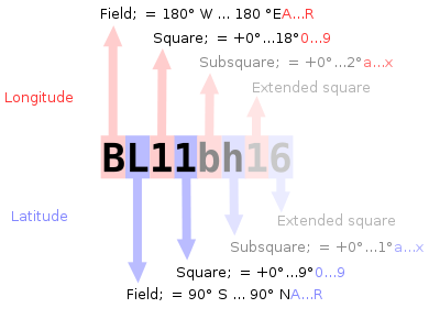
The chosen coding uses alternating pairs of letters and digits, like so:
-
-
- BL11bh16
-
In each pair, the first character encodes longitude and the second character encodes latitude. These character pairs also have traditional names, and in the case of letters, the range of characters (or "encoding base number") used in each pair does vary.
In order to avoid negative numbers in the input data, the system also specifies that latitude is measured from the South Pole
South Pole
The South Pole, also known as the Geographic South Pole or Terrestrial South Pole, is one of the two points where the Earth's axis of rotation intersects its surface. It is the southernmost point on the surface of the Earth and lies on the opposite side of the Earth from the North Pole...
to the North Pole
North Pole
The North Pole, also known as the Geographic North Pole or Terrestrial North Pole, is, subject to the caveats explained below, defined as the point in the northern hemisphere where the Earth's axis of rotation meets its surface...
, and longitude measured eastward from the antimeridian of Greenwich
Greenwich
Greenwich is a district of south London, England, located in the London Borough of Greenwich.Greenwich is best known for its maritime history and for giving its name to the Greenwich Meridian and Greenwich Mean Time...
, giving the Prime Meridian
Prime Meridian
The Prime Meridian is the meridian at which the longitude is defined to be 0°.The Prime Meridian and its opposite the 180th meridian , which the International Date Line generally follows, form a great circle that divides the Earth into the Eastern and Western Hemispheres.An international...
a false easting
Easting and northing
The terms easting and northing are geographic Cartesian coordinates for a point. Easting refers to the eastward-measured distance , while northing refers to the northward-measured distance...
of 180° and the equator
Equator
An equator is the intersection of a sphere's surface with the plane perpendicular to the sphere's axis of rotation and containing the sphere's center of mass....
a false northing
Easting and northing
The terms easting and northing are geographic Cartesian coordinates for a point. Easting refers to the eastward-measured distance , while northing refers to the northward-measured distance...
of 90°.
To simplify manual encoding, the base for the first pair of letters—traditionally called a field—was chosen to be 18, thus dividing the globe into 18 zones of longitude of 20° each, and 18 zones of latitude 10° each. These zones are encoded with the letters "A" through "R".
The first pair of numbers, called a square and placed after the first pair of letters, uses a base number of 10, and is encoded using the digits "0" to "9". This is where the alternative name "grid squares" comes from. Each of these squares represents 1° of latitude by 2° of longitude.
For additional precision, each square can optionally be sub-divided further, into subsquares. These are encoded into a second pair of letters, often (but not always) presented in lowercase, and again, to make manual calculations from degrees and minutes easier, 24 was chosen as the base number, giving these subsquares dimensions of 2.5' of latitude by 5' of longitude. The letters used are "A" through "X".
The resulting Maidenhead subsquare locator string is hence composed of two letters, two digits, and two more letters. To give an example, W1AW, the American Radio Relay League's
American Radio Relay League
The American Radio Relay League is the largest membership association of amateur radio enthusiasts in the USA. ARRL is a non-profit organization, and was founded in May 1914 by Hiram Percy Maxim of Hartford, Connecticut...
Hiram Percy Maxim
Hiram Percy Maxim
Hiram Percy Maxim was an American radio pioneer and inventor, and co-founder of the American Radio Relay League . He originally had the amateur call signs SNY, 1WH, 1ZM, 1AW, and later W1AW, which is now the ARRL Headquarters club station call sign...
Memorial Station in Newington, Connecticut
Newington, Connecticut
Newington is a town in Hartford County, Connecticut, United States. As of the 2000 census, it had a total population of 29,306. The Connecticut Department of Transportation has its headquarters in Newington....
, is found in grid locator . Two points within the same Maidenhead subsquare are always less than 12 km apart, which means a Maidenhead locator can give significant precision from just six easily transmissible characters.
The Maidenhead locator system has been explicitly based on the WGS 84 geodetic datum since 1999. Before that time, it was usually based on each user's local national datum, which do differ slightly from one another and WGS 84. As a result, stations very near the edges of squares at denoted precision may have changed their locators when changing over to the use of WGS 84.
To summarize:
- Character pairs encode longitudeLongitudeLongitude is a geographic coordinate that specifies the east-west position of a point on the Earth's surface. It is an angular measurement, usually expressed in degrees, minutes and seconds, and denoted by the Greek letter lambda ....
first, and then latitudeLatitudeIn geography, the latitude of a location on the Earth is the angular distance of that location south or north of the Equator. The latitude is an angle, and is usually measured in degrees . The equator has a latitude of 0°, the North pole has a latitude of 90° north , and the South pole has a...
. - The first pair (a field) encodes with base 18 and the letters "A" to "R".
- The second pair (square) encodes with base 10 and the digits "0" to "9".
- The third pair (subsquare) encodes with base 24 and the letters "A" to "X".
- The fourth pair (extended square) encodes with base 10 and the digits "0" to "9".
- The fifth and subsequent pairs are not formally defined, but recycling the third and fourth pair algorithms is one possible definition:
-
-
- BL11bh16oo66
-
On shortwave
Shortwave
Shortwave radio refers to the upper MF and all of the HF portion of the radio spectrum, between 1,800–30,000 kHz. Shortwave radio received its name because the wavelengths in this band are shorter than 200 m which marked the original upper limit of the medium frequency band first used...
frequencies, positions are reported at square precision, and on VHF and UHF, subsquare precision is used. More precise position reports are very rarely used.
Use by radio amateurs
Today, individual radio amateurs and organizations around the world recognize and use Maidenhead locators. Many utilities exist to convert latitude and longitude to locators, as this is a favorite hack for programmers who are also radio amateurs. Commercially available (civil) Global Positioning SystemGlobal Positioning System
The Global Positioning System is a space-based global navigation satellite system that provides location and time information in all weather, anywhere on or near the Earth, where there is an unobstructed line of sight to four or more GPS satellites...
receivers are frequently able to display Maidenhead locators.
Maidenhead locators are used as part of the formulas for scoring in many VHF amateur radio contests
Contesting
Contesting is a competitive activity pursued by amateur radio operators. In a contest, an amateur radio station, which may be operated by an individual or a team, seeks to contact as many other amateur radio stations as possible in a given period of time and exchange information...
. Grid locators are also the basis of earning many awards like the American Radio Relay League's VHF/UHF Century Club
VHF/UHF Century Club
The VHF/UHF Century Club, or VUCC, is an award granted by the American Radio Relay League. The award is given to those amateur radio operators who successfully complete amateur radio communications with other amateur radio stations in a specified number of Maidenhead grid locators...
, URE TTLOC, etc. operating award.
In IARU Region 1 rules, VHF distance calculations are carried out between Maidenhead subsquare centers assuming a spherical Earth. This results in a small error in distance, but makes calculations simpler and, given the inherent imprecision in the used input data, it is not the biggest error source.
External links
- ARRLWeb: Grid Locators and Grid Squares
- ARRLWeb: Calculate Grid Square
- From the field hunter's web page: An explanation of the system and how it came into being.
- Maidenhead Grid Squares
- Find QTH locator or Maidenhead grid square, at arbitrary sub-level, and approximate distance and bearing between two squares
- Find QTH locator or Maidenhead grid square, at maximum 6 character level, and approximate distance and bearing between two squares
- Generate a KML file that outlines a grid position