Magsat
Encyclopedia
Spacecraft
A spacecraft or spaceship is a craft or machine designed for spaceflight. Spacecraft are used for a variety of purposes, including communications, earth observation, meteorology, navigation, planetary exploration and transportation of humans and cargo....
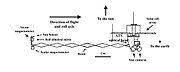
was launched in the fall of 1979 and ended in the spring of 1980. The mission was to map the Earth's magnetic field
Earth's magnetic field
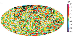
Earth's magnetic field is the magnetic field that extends from the Earth's inner core to where it meets the solar wind, a stream of energetic particles emanating from the Sun...
, the satellite
Satellite
In the context of spaceflight, a satellite is an object which has been placed into orbit by human endeavour. Such objects are sometimes called artificial satellites to distinguish them from natural satellites such as the Moon....
has two magnetometer
Magnetometer
A magnetometer is a measuring instrument used to measure the strength or direction of a magnetic field either produced in the laboratory or existing in nature...
s. The scalar (Cesium vapor) and vector (fluxgate) magnetometers gave Magsat a capability beyond that of any previous spacecraft. Extended by a telescoping boom, the magnetometers were distanced from the magnetic field created by the satellite and its electronics. The satellite carried two magnetometers, a three-axis fluxgate magnetometer for determining the strength and direction of magnetic fields, and an ion-vapor/vector magnetometer for determining the magnetic field caused by the vector magnetometer itself.
MAGSAT is considered to be one of the more important Science/Earth orbiting satellites launched; the data it accumulated is still being used, particularly in linking new satellite data to past observations.