

Mackenzie dike swarm
Encyclopedia
Large igneous province
A Large Igneous Province is an extremely large accumulation of igneous rocks—intrusive, extrusive, or both—in the earth's crust...
in the western Canadian Shield
Canadian Shield
The Canadian Shield, also called the Laurentian Plateau, or Bouclier Canadien , is a vast geological shield covered by a thin layer of soil that forms the nucleus of the North American or Laurentia craton. It is an area mostly composed of igneous rock which relates to its long volcanic history...
of Canada
Canada
Canada is a North American country consisting of ten provinces and three territories. Located in the northern part of the continent, it extends from the Atlantic Ocean in the east to the Pacific Ocean in the west, and northward into the Arctic Ocean...
. It is part of the larger Mackenzie Large Igneous Province
Mackenzie Large Igneous Province
The Mackenzie Large Igneous Province is a major Mesoproterozoic large igneous province of the southwestern, western and northwestern Canadian Shield in Canada. It consists of a group of related igneous rocks that were formed during a massive igneous event starting about 1,270 million years ago...
and is one of more than three dozen dike swarm
Dike swarm
A dike swarm or dyke swarm is a large geological structure consisting of a major group of parallel, linear, or radially oriented dikes intruded within continental crust. They consist of several to hundreds of dikes emplaced more or less contemporaneously during a single intrusive event and are...
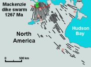
s in various parts of the Canadian Shield. It is the largest dike swarm known on Earth
Earth
Earth is the third planet from the Sun, and the densest and fifth-largest of the eight planets in the Solar System. It is also the largest of the Solar System's four terrestrial planets...
, more than 500 km (310.7 mi) wide and 3000 km (1,864.1 mi) long, extending in a northwesterly direction across the whole of Canada from the Arctic
Arctic
The Arctic is a region located at the northern-most part of the Earth. The Arctic consists of the Arctic Ocean and parts of Canada, Russia, Greenland, the United States, Norway, Sweden, Finland, and Iceland. The Arctic region consists of a vast, ice-covered ocean, surrounded by treeless permafrost...
to the Great Lakes
Great Lakes
The Great Lakes are a collection of freshwater lakes located in northeastern North America, on the Canada – United States border. Consisting of Lakes Superior, Michigan, Huron, Erie, and Ontario, they form the largest group of freshwater lakes on Earth by total surface, coming in second by volume...
. The mafic
Mafic
Mafic is an adjective describing a silicate mineral or rock that is rich in magnesium and iron; the term is a portmanteau of the words "magnesium" and "ferric". Most mafic minerals are dark in color and the relative density is greater than 3. Common rock-forming mafic minerals include olivine,...
dikes cut Archean
Archean
The Archean , also spelled Archeozoic or Archæozoic) is a geologic eon before the Paleoproterozoic Era of the Proterozoic Eon, before 2.5 Ga ago. Instead of being based on stratigraphy, this date is defined chronometrically...
and Proterozoic
Proterozoic
The Proterozoic is a geological eon representing a period before the first abundant complex life on Earth. The name Proterozoic comes from the Greek "earlier life"...
rocks, including those in the Athabasca Basin
Athabasca Basin
This article is about the uranium mining region near Lake Athabasca. Not to be confused with the drainage basin of the Athabasca River.The Athabasca Basin is a region of Northern Saskatchewan and Alberta Canada that is best known as the world's leading source of high grade uranium...
in Saskatchewan
Saskatchewan
Saskatchewan is a prairie province in Canada, which has an area of . Saskatchewan is bordered on the west by Alberta, on the north by the Northwest Territories, on the east by Manitoba, and on the south by the U.S. states of Montana and North Dakota....
, Thelon Basin in Nunavut
Nunavut
Nunavut is the largest and newest federal territory of Canada; it was separated officially from the Northwest Territories on April 1, 1999, via the Nunavut Act and the Nunavut Land Claims Agreement Act, though the actual boundaries had been established in 1993...
and the Baker Lake Basin in the Northwest Territories
Northwest Territories
The Northwest Territories is a federal territory of Canada.Located in northern Canada, the territory borders Canada's two other territories, Yukon to the west and Nunavut to the east, and three provinces: British Columbia to the southwest, and Alberta and Saskatchewan to the south...
.
Coppermine River Group
Vast volumes of basaltBasalt
Basalt is a common extrusive volcanic rock. It is usually grey to black and fine-grained due to rapid cooling of lava at the surface of a planet. It may be porphyritic containing larger crystals in a fine matrix, or vesicular, or frothy scoria. Unweathered basalt is black or grey...
ic lava
Lava
Lava refers both to molten rock expelled by a volcano during an eruption and the resulting rock after solidification and cooling. This molten rock is formed in the interior of some planets, including Earth, and some of their satellites. When first erupted from a volcanic vent, lava is a liquid at...
paved over a large area in the western Canadian Shield
Canadian Shield
The Canadian Shield, also called the Laurentian Plateau, or Bouclier Canadien , is a vast geological shield covered by a thin layer of soil that forms the nucleus of the North American or Laurentia craton. It is an area mostly composed of igneous rock which relates to its long volcanic history...
in the form of a flood basalt
Flood basalt
A flood basalt or trap basalt is the result of a giant volcanic eruption or series of eruptions that coats large stretches of land or the ocean floor with basalt lava. Flood basalts have occurred on continental scales in prehistory, creating great plateaus and mountain ranges...
event. This massive eruptive event occurred during the Mesoproterozoic
Mesoproterozoic
The Mesoproterozoic Era is a geologic era that occurred between 1600 Ma and 1000 Ma . The Mesoproterozoic was the first period of Earth's history with a respectable geological record. Continents existed in the Paleoproterozoic, but we know little about them...
era about 1,267 million years ago. Today the thickness of these flood basalts range from 2000 m (6,561.7 ft) to 3500 m (11,482.9 ft) and consists of about 150 lava flows, each about 10 m (32.8 ft) to 25 m (82 ft) thick, which are part of the Copper Creek Formation. Except for the lowermost lava flows, which contain evidence of interaction with water, the entire sequence was erupted subaerially. Eruption of plateau
Plateau
In geology and earth science, a plateau , also called a high plain or tableland, is an area of highland, usually consisting of relatively flat terrain. A highly eroded plateau is called a dissected plateau...
lavas near the Coppermine River
Coppermine River
The Coppermine River is a river in the North Slave and Kitikmeot regions of the Northwest Territories and Nunavut in Canada. It is long. It rises in Lac de Gras, a small lake near Great Slave Lake and flows generally north to Coronation Gulf, an arm of the Arctic Ocean...
built an extensive volcanic plateau
Volcanic plateau
A volcanic plateau is a plateau produced by volcanic activity. There are two main types: lava plateaus and pyroclastic plateaus.-Lava plateau:...
about 1,200 million years ago with an area of about 170000 km³ (40,785 cu mi), representing a volume of lavas of at least 500000 km³ (119,956 cu mi). This basalt sequence has been called the Coppermine River Group and may have been contemporaneous with the Mackenzie dikes and with the Muskox intrusion
Muskox intrusion
The Muskox intrusion is a layered intrusion in Nunavut, Canada. It is located northeast of Great Bear Lake and south of Kugluktuk on Coronation Gulf...
.
Origin and history
The source for the Mackenzie dike swarm is considered to be a mantle plumeMantle plume
A mantle plume is a hypothetical thermal diapir of abnormally hot rock that nucleates at the core-mantle boundary and rises through the Earth's mantle. Such plumes were invoked in 1971 to explain volcanic regions that were not thought to be explicable by the then-new theory of plate tectonics. Some...
center called the Mackenzie hotspot
Mackenzie hotspot
The Mackenzie hotspot was a volcanic hotspot that existed about 1,267 million years ago across Canada from the Northwest Territories and Nunavut. It is responsible for the creation of the Mackenzie Large Igneous Province, which contains the largest dike swarm on Earth...
. About 1,268 million years ago, the Slave craton
Slave craton
The Slave craton is a Canadian geological formation located in the Northwest Territories and Nunavut. This craton is approximately in size and forms part of the Canadian Shield. It is dominated by ca. 2.73-2.63 Ga greenstones and turbidite sequences and ca. 2.72-2.58 Ga plutonic rock, with large...
was partly uplifted and intruded by the giant Mackenzie dike swarm. This was the last major event to affect the core of the Slave craton, although later on some younger mafic
Mafic
Mafic is an adjective describing a silicate mineral or rock that is rich in magnesium and iron; the term is a portmanteau of the words "magnesium" and "ferric". Most mafic minerals are dark in color and the relative density is greater than 3. Common rock-forming mafic minerals include olivine,...
magmatism registered along its edges.
See also
- Bear River dikesBear River dikesThe Bear River dikes are a 1,265 to 1,269 million year old group of dikes in northern Yukon, Canada. They represent a feature related to magmatism of the extensive Mackenzie Large Igneous Province and are considered to be the western extension of the northwest-southeast trending Mackenzie...
- Volcanism of Canada
- Volcanism of Northern CanadaVolcanism of Northern CanadaVolcanism of Northern Canada has led to the formation of hundreds of volcanic areas and extensive lava formations across Northern Canada, indicating volcanism played a major role in shaping its surface...
- Volcanism of Western CanadaVolcanism of Western CanadaVolcanism of Western Canada produces lava flows, lava plateaus, lava domes, cinder cones, stratovolcanoes, shield volcanoes, submarine volcanoes, calderas, diatremes and maars, along with examples of more less common volcanic forms such as tuyas and subglacial mounds.-Volcanic belts:*Anahim...
- Volcanism of Eastern CanadaVolcanism of Eastern CanadaVolcanism of Eastern Canada has led to the formation of hundreds of volcanic areas and extensive lava formations, indicating volcanism played a major role in shaping its surface. The region's different volcano and lava types originate from different tectonic settings and types of volcanic...
- List of volcanoes in Canada