
Mackenzie Highway
Encyclopedia
The Mackenzie Highway is a Canadian highway in northern Alberta
and the Northwest Territories
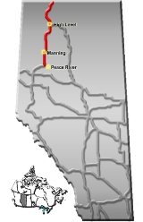
. It begins as Alberta Highway 2 at Mile Zero in Grimshaw, Alberta
. After the first 5 km (3.1 mi), it becomes Alberta Highway 35
for the balance of its length through Alberta and then becomes Northwest Territories Highway 1.
Originally begun prior to World War II
, the project was abandoned at the outbreak of war, then resumed in the early 1960s and completed to Hay River, Northwest Territories
.
In 1966-67, it was extended from Enterprise
, approximately 23.6 miles (38 km) south of Hay River, to the northwest, then north past Fort Providence
to Behchoko
(at the time, known as Rae-Edzo) and southeast to the City of Yellowknife, the capital of the Northwest Territories. Much of this extension is now known as Northwest Territories Highway 3, the Yellowknife Highway. (The 23.6 miles (38 km) stretch from Enterprise to Hay River is Highway 2).
In approximately 1970, the highway was extended west from what is now the southern terminus of Highway 3 to reach Fort Simpson
, and in 1971, when the section to Fort Simpson was opened to traffic, work began to prepare a road grade from there to Wrigley, but the work was abandoned. This roadway, which starts at a junction 2.2 miles (3.5 km) from the island that "downtown" Fort Simpson is situated on, was finally made usable in 1994, and includes the N'dulee ferry and ice crossings.
There are social and economic studies being done on the extension of the highway north from Wrigley to join the Dempster Highway
.
Just east of Fort Simpson's airport, the highway crosses the Liard River
by ferry
(summer) and ice bridge
(winter). 27.9 miles (45 km) further east of this crossing, the location known as Checkpoint is the site of a former gas station at the junction with the Liard Highway (Northwest Territories Highway 7, British Columbia Highway 77) from Fort Nelson, British Columbia
.
Alberta
Alberta is a province of Canada. It had an estimated population of 3.7 million in 2010 making it the most populous of Canada's three prairie provinces...
and the Northwest Territories
Northwest Territories
The Northwest Territories is a federal territory of Canada.Located in northern Canada, the territory borders Canada's two other territories, Yukon to the west and Nunavut to the east, and three provinces: British Columbia to the southwest, and Alberta and Saskatchewan to the south...
. It begins as Alberta Highway 2 at Mile Zero in Grimshaw, Alberta
Grimshaw, Alberta
Grimshaw is a town in northern Alberta located west of the Town of Peace River at the junction of Highway 35, Highway 2, and bypass Highway 2A, and the Mackenzie Northern Railway...
. After the first 5 km (3.1 mi), it becomes Alberta Highway 35
Alberta Highway 35
Alberta Highway 35, which forms the majority of Alberta's portion of the Mackenzie Highway, is a north–south highway in northwest Alberta....
for the balance of its length through Alberta and then becomes Northwest Territories Highway 1.
Originally begun prior to World War II
World War II
World War II, or the Second World War , was a global conflict lasting from 1939 to 1945, involving most of the world's nations—including all of the great powers—eventually forming two opposing military alliances: the Allies and the Axis...
, the project was abandoned at the outbreak of war, then resumed in the early 1960s and completed to Hay River, Northwest Territories
Hay River, Northwest Territories
Hay River , known as "the Hub of the North," is a town in the Northwest Territories, Canada, located on the south shore of Great Slave Lake, at the mouth of the Hay River. The town is separated into two sections, a new town and an old town with the Hay River Airport between them...
.
In 1966-67, it was extended from Enterprise
Enterprise, Northwest Territories
Enterprise is a hamlet in the South Slave Region of the Northwest Territories, Canada, located between Great Slave Lake and the Alberta border on the Hay River....
, approximately 23.6 miles (38 km) south of Hay River, to the northwest, then north past Fort Providence
Fort Providence, Northwest Territories
Fort Providence is a hamlet in the South Slave Region of the Northwest Territories, Canada...
to Behchoko
Behchoko, Northwest Territories
Behchokǫ̀ , officially the Tłı̨chǫ Community Government of Behchokǫ̀ is a community in the North Slave Region of the Northwest Territories, Canada. Behchokǫ̀ is located on the Yellowknife Highway , on the northwest tip of Great Slave Lake, approximately northwest of Yellowknife...
(at the time, known as Rae-Edzo) and southeast to the City of Yellowknife, the capital of the Northwest Territories. Much of this extension is now known as Northwest Territories Highway 3, the Yellowknife Highway. (The 23.6 miles (38 km) stretch from Enterprise to Hay River is Highway 2).
In approximately 1970, the highway was extended west from what is now the southern terminus of Highway 3 to reach Fort Simpson
Fort Simpson, Northwest Territories
Fort Simpson is a village in the Dehcho Region of the Northwest Territories, Canada. The community is located on an island at the confluence of the Mackenzie and Liard Rivers...
, and in 1971, when the section to Fort Simpson was opened to traffic, work began to prepare a road grade from there to Wrigley, but the work was abandoned. This roadway, which starts at a junction 2.2 miles (3.5 km) from the island that "downtown" Fort Simpson is situated on, was finally made usable in 1994, and includes the N'dulee ferry and ice crossings.
There are social and economic studies being done on the extension of the highway north from Wrigley to join the Dempster Highway
Dempster Highway
The Dempster Highway, also referred to as Yukon Highway 5 and Northwest Territories Highway 8, is a highway that connects the Klondike Highway in Yukon, Canada to Inuvik, Northwest Territories on the Mackenzie River delta...
.
Just east of Fort Simpson's airport, the highway crosses the Liard River
Liard River
The Liard River flows through Yukon, British Columbia and the Northwest Territories, Canada. Rising in the Saint Cyr Range of the Pelly Mountains in southeastern Yukon, it flows southeast through British Columbia, marking the northern end of the Rocky Mountains and then curving northeast back...
by ferry
Ferry
A ferry is a form of transportation, usually a boat, but sometimes a ship, used to carry primarily passengers, and sometimes vehicles and cargo as well, across a body of water. Most ferries operate on regular, frequent, return services...
(summer) and ice bridge
Ice road
Ice roads are frozen, human-made structures on the surface of bays, rivers, lakes, or seas in the far north. They link dry land, frozen waterways, portages and winter roads, and are usually remade each winter. Ice roads allow temporary transport to areas with no permanent road access...
(winter). 27.9 miles (45 km) further east of this crossing, the location known as Checkpoint is the site of a former gas station at the junction with the Liard Highway (Northwest Territories Highway 7, British Columbia Highway 77) from Fort Nelson, British Columbia
Fort Nelson, British Columbia
Fort Nelson is a town of approximately 5000 residents in British Columbia's northeastern corner. It is the administrative centre of the newly formed Northern Rockies Regional Municipality, a first for BC. The majority of Fort Nelson's economic activities have historically been concentrated in the...
.