

MacDonnell Ranges
Encyclopedia
The MacDonnell Ranges of the Northern Territory
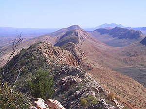
, are a 644 km (400.2 mi) long series of mountain ranges located in the centre of Australia
(23°42′S 132°30′E), and consist of parallel ridges running to the east and west of Alice Springs. The mountain range contains many spectacular gaps and gorges as well as areas of aboriginal significance.
The ranges were named after Sir Richard MacDonnell
(the Governor of South Australia at the time) by John McDouall Stuart
, whose 1860 expedition reached them in April of that year. The Horn Expedition
investigated the ranges as part of the scientific expedition into central Australia. Other explorers of the range included David Lindsay
and John Ross
.
The MacDonnell Ranges were often depicted in the paintings of Albert Namatjira
.
(1,531 m AHD
/ 5,023 ft), Mount Liebig
(1524 m / 5,000 ft) and Mount Sonder
(1,380 m / 4,528 ft). These are the tallest mountains in the Northern Territory. The MacDonnell Ranges are the headwaters of the Todd River
, Finke River
and Sandover River
s. The range is crossed by the Australian Overland Telegraph Line
and the Stuart Highway
.
peaks and gorges. Other rock types include granite
, limestone
, sandstone
and siltstone
. Some of the valleys of the range contain fossil evidence of the inland sea that once covered central Australia.
ecoregion
of dry scrubby grassland the ranges are home to a large number of endemic species including the Centralian Tree Frog
. This is mostly due to the micro climates that are found around the cold rock pools. Some pools are so cold that hypothermia can set in after a few minutes of swimming.
 The West MacDonnell National Park
was established in 1984 to protect the numerous parks and reserves of the range. It also facilitated the development of the Larapinta Trail
.
To the east of Alice Springs, within an hours drive, are sites important to the local Arrernte
people, many of which contain examples of Aboriginal rock art
. These include Emily Gap, Jessie Gap, Trephina Gorge and N’Dhala Gorge.
To the west of Alice Springs is the Larapinta Trail
—a world-class, long distance bush walking trail that runs 223 kilometres along the backbone of the range.
Along the trail is Simpsons Gap, Standley Chasm, Ellery Creek Big Hole, Serpentine Gorge
, Ochre Pits
, Ormiston Pound
, Redbank Gorge, Glen Helen Gorge, Tnorala Gosse Bluff
, Palm Valley, Mount Sonder
, Mount Zeil
and Mount Giles
.
Northern Territory
The Northern Territory is a federal territory of Australia, occupying much of the centre of the mainland continent, as well as the central northern regions...
, are a 644 km (400.2 mi) long series of mountain ranges located in the centre of Australia
Australia
Australia , officially the Commonwealth of Australia, is a country in the Southern Hemisphere comprising the mainland of the Australian continent, the island of Tasmania, and numerous smaller islands in the Indian and Pacific Oceans. It is the world's sixth-largest country by total area...
(23°42′S 132°30′E), and consist of parallel ridges running to the east and west of Alice Springs. The mountain range contains many spectacular gaps and gorges as well as areas of aboriginal significance.
The ranges were named after Sir Richard MacDonnell
Richard Graves MacDonnell
Sir Richard Graves MacDonnell KCMG CB was an Anglo-Irish lawyer, judge and colonial governor...
(the Governor of South Australia at the time) by John McDouall Stuart
John McDouall Stuart
John McDouall Stuart was one of the most accomplished and famous of all Australia's inland explorers. Stuart led the first successful expedition to traverse the Australian mainland from south to north and return, and the first to do so from a starting point in South Australia, achieving this...
, whose 1860 expedition reached them in April of that year. The Horn Expedition
Horn Expedition
The Horn Scientific Expedition was the first primarily scientific expedition to study the natural history of Central Australia. It took place from May to August 1894, with expedition members first traveling by train from Adelaide to the railhead at Oodnadatta in South Australia, then using camels...
investigated the ranges as part of the scientific expedition into central Australia. Other explorers of the range included David Lindsay
David Lindsay (explorer)
David Lindsay was an Australian explorer and surveyor and a fellow of the Royal Geographical Society, London.-Early life:...
and John Ross
John Ross (explorer)
John Ross was a Scottish Australian drover and explorer.Ross was born in Bridgend, Scotland. He emigrated to Australia in 1837, arriving in Sydney on 31 August 1837. He first gained employment as a shepherd for George Macleay and in 1838 he joined Charles Bonney in the first cattle drive from the...
.
The MacDonnell Ranges were often depicted in the paintings of Albert Namatjira
Albert Namatjira
Albert Namatjira , born Elea Namatjira, was an Australian artist. He was a Western Arrernte man, an Indigenous Australian of the Western MacDonnell Ranges area...
.
Geography
The highest peaks are Mount ZeilMount Zeil
Mount Zeil is a mountain situated in the western MacDonnell Ranges in Australia's Northern Territory. It is the highest peak in the Northern Territory, and the highest peak in Australia west of the Great Dividing Range .It is believed that Mount Zeil was named during or following Ernest Giles'...
(1,531 m AHD
Australian Height Datum
The Australian Height Datum is a geodetic datum for altitude measurement in Australia. According to Geoscience Australia, "In 1971 the mean sea level for 1966-1968 was assigned the value of zero on the Australian Height Datum at thirty tide gauges around the coast of the Australian continent...
/ 5,023 ft), Mount Liebig
Mount Liebig
Mount Liebig is a mountain with an altitude of 1524 m in the southern part of the Northern Territory of Australia. It is one of the highest peaks of the MacDonnell Ranges and was named by the explorer Ernest Giles after the German chemist Justus von Liebig...
(1524 m / 5,000 ft) and Mount Sonder
Mount Sonder
Mount Sonder, or Rwetyepme, its Aboriginal name, is the fourth highest mountain in the Northern Territory, Australia at 1380 metres above sea level. Mount Zeil is the highest at 1531 metres, 27 kilometres to the west. It is west of Alice Springs along the MacDonnell Ranges in the West MacDonnell...
(1,380 m / 4,528 ft). These are the tallest mountains in the Northern Territory. The MacDonnell Ranges are the headwaters of the Todd River
Todd River
The Todd River is an ephemeral river in the southern Northern Territory, central Australia. The origins of the Todd River begin in the MacDonnell Ranges, where it flows past the Telegraph Station, almost through the center of Alice Springs, through Heavitree Gap at the southern end of Alice Springs...
, Finke River
Finke River
The Finke River is one of the largest rivers in central Australia. Its source is in the Northern Territory's MacDonnell Ranges, and the name Finke River is first applied at the confluence of the Davenport and Ormiston Creeks, just north of Glen Helen. From here the river meanders for approximately...
and Sandover River
Sandover River
The Sandover River is a river in northeast Central Australia. It is the only major tributary of the Georgina River that does not rise in western Queensland. Instead it flows from the eastern Macdonnell Ranges in the Northern Territory northward to enter the Georgina near Urandangi...
s. The range is crossed by the Australian Overland Telegraph Line
Australian Overland Telegraph Line
The Australian Overland Telegraph Line was a 3200 km telegraph line that connected Darwin with Port Augusta in South Australia. Completed in 1872 the Overland Telegraph Line allowed fast communication between Australia and the rest of the world. An additional section was added in 1877 with the...
and the Stuart Highway
Stuart Highway
The Stuart Highway is one of Australia's major highways. It is a segment of Australia's Highway 1 extending from Darwin, Northern Territory, in the north, via Tennant Creek and Alice Springs, to Port Augusta, South Australia, in the south—a distance of...
.
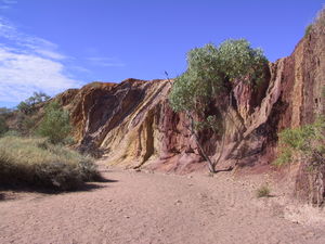
Geology
350-300 million years ago a mountain building event created the MacDonnell Ranges. Since that time, folding, faulting and erosion have shaped the range and created numerous gaps and gorges. The ranges are composed of many rock types, but are most famous for their red quartziteQuartzite
Quartzite is a hard metamorphic rock which was originally sandstone. Sandstone is converted into quartzite through heating and pressure usually related to tectonic compression within orogenic belts. Pure quartzite is usually white to gray, though quartzites often occur in various shades of pink...
peaks and gorges. Other rock types include granite
Granite
Granite is a common and widely occurring type of intrusive, felsic, igneous rock. Granite usually has a medium- to coarse-grained texture. Occasionally some individual crystals are larger than the groundmass, in which case the texture is known as porphyritic. A granitic rock with a porphyritic...
, limestone
Limestone
Limestone is a sedimentary rock composed largely of the minerals calcite and aragonite, which are different crystal forms of calcium carbonate . Many limestones are composed from skeletal fragments of marine organisms such as coral or foraminifera....
, sandstone
Sandstone
Sandstone is a sedimentary rock composed mainly of sand-sized minerals or rock grains.Most sandstone is composed of quartz and/or feldspar because these are the most common minerals in the Earth's crust. Like sand, sandstone may be any colour, but the most common colours are tan, brown, yellow,...
and siltstone
Siltstone
Siltstone is a sedimentary rock which has a grain size in the silt range, finer than sandstone and coarser than claystones.- Description :As its name implies, it is primarily composed of silt sized particles, defined as grains 1/16 - 1/256 mm or 4 to 8 on the Krumbein phi scale...
. Some of the valleys of the range contain fossil evidence of the inland sea that once covered central Australia.
Ecology
Part of the Central Ranges xeric scrubCentral Ranges xeric scrub
The Central Ranges xeric scrub is a deserts and xeric shrublands ecoregion of Australia. -Location and description:The region consists of sandy plains with some areas of rocky highland. These plains have a dry climate but do get some rain in both summer and winter...
ecoregion
Ecoregion
An ecoregion , sometimes called a bioregion, is an ecologically and geographically defined area that is smaller than an ecozone and larger than an ecosystem. Ecoregions cover relatively large areas of land or water, and contain characteristic, geographically distinct assemblages of natural...
of dry scrubby grassland the ranges are home to a large number of endemic species including the Centralian Tree Frog
Centralian Tree Frog
The Centralian Tree Frog is a large species of tree frog native to a small area in central Australia. It is closely related to the Australian Green Tree Frog , and closely resembles it in appearance....
. This is mostly due to the micro climates that are found around the cold rock pools. Some pools are so cold that hypothermia can set in after a few minutes of swimming.
Tourist attractions
West MacDonnell National Park
West MacDonnell is a national park in the Northern Territory , 1234 km south of Darwin. It extends along the MacDonnell Ranges west of Alice Springs....
was established in 1984 to protect the numerous parks and reserves of the range. It also facilitated the development of the Larapinta Trail
Larapinta Trail
The Larapinta Trail is an extended walking track in the Northern Territory, Australia. Its total length covers from East to West, with one end at Alice Springs and the other at Mount Sonder, one of the territory's highest mountains...
.
To the east of Alice Springs, within an hours drive, are sites important to the local Arrernte
Arrernte people
The Arrernte people , known in English as the Aranda or Arunta, are those Indigenous Australians who are the original custodians of Arrernte lands in the central area of Australia around Mparntwe or Alice Springs in the Northern Territory. The Arrernte tribe has lived there for more than 20,000 years...
people, many of which contain examples of Aboriginal rock art
Rock art
Rock art is a term used in archaeology for any human-made markings made on natural stone. They can be divided into:*Petroglyphs - carvings into stone surfaces*Pictographs - rock and cave paintings...
. These include Emily Gap, Jessie Gap, Trephina Gorge and N’Dhala Gorge.
To the west of Alice Springs is the Larapinta Trail
Larapinta Trail
The Larapinta Trail is an extended walking track in the Northern Territory, Australia. Its total length covers from East to West, with one end at Alice Springs and the other at Mount Sonder, one of the territory's highest mountains...
—a world-class, long distance bush walking trail that runs 223 kilometres along the backbone of the range.
Along the trail is Simpsons Gap, Standley Chasm, Ellery Creek Big Hole, Serpentine Gorge
Serpentine Gorge
Serpentine Gorge is one of the gorges in the West MacDonnell Ranges in Australia's Northern Territory. It is located approximately 100 kilometres west of Alice Springs along the Larapinta Trail....
, Ochre Pits
Ochre Pits
The Ochre Pits are a popular tourist destination in Australia's Northern Territory, approximately 50 kilometres west of Alice Springs along the Larapinta Trail....
, Ormiston Pound
Ormiston Pound
Ormiston Pound is a ring of mountains punctuating the MacDonnell Ranges, in the West MacDonnell National Park, approximately 135 kilometres west of Alice Springs in the Northern Territory, Australia...
, Redbank Gorge, Glen Helen Gorge, Tnorala Gosse Bluff
Gosses Bluff crater
Gosses Bluff is thought to be the eroded remnant of an impact crater. It is located in the southern Northern Territory, near the centre of Australia, about west of Alice Springs and about to the northeast of Uluru...
, Palm Valley, Mount Sonder
Mount Sonder
Mount Sonder, or Rwetyepme, its Aboriginal name, is the fourth highest mountain in the Northern Territory, Australia at 1380 metres above sea level. Mount Zeil is the highest at 1531 metres, 27 kilometres to the west. It is west of Alice Springs along the MacDonnell Ranges in the West MacDonnell...
, Mount Zeil
Mount Zeil
Mount Zeil is a mountain situated in the western MacDonnell Ranges in Australia's Northern Territory. It is the highest peak in the Northern Territory, and the highest peak in Australia west of the Great Dividing Range .It is believed that Mount Zeil was named during or following Ernest Giles'...
and Mount Giles
Mount Giles
Mount Giles is one of the highest mountains in the Northern Territory, Australia, at 1389 metres AHD. It lies along the MacDonnell Ranges, dominating Ormiston Pound, in the West MacDonnell National Park, approximately 80 kilometres west of Alice Springs...
.
See also
- List of mountains in Australia
- Pine GapPine GapPine Gap is the commonly used name for a satellite tracking station at, some south-west of the town of Alice Springs in the centre of Australia which is operated by both Australia and the United States. The facility has become a key part of the local economy.It consists of a large computer complex...
- Western ArrernteWestern ArrernteWestern Arrernte refers to Arrernte people who traditionally live in Arrernte lands west of Alice Springs. It also refers to a dialect of the Arrernte language that is spoken in this area. Some people argue that Western Arrernte is an entirely different language and group of people to Central...