
.gif)
M-26 (Michigan highway)
Encyclopedia
M-26 is a 96.355 miles (155.068 km) state trunkline highway
in the U.S. state of Michigan
, running from two miles (3 km) east of Rockland to its junction with US Highway 41
(US 41) in Copper Harbor
. It generally runs southwest-to-northeast in the western half or Michigan's Upper Peninsula
. The northernmost segment, which closely parallels the shore of Lake Superior
on the west side of the Keweenaw Peninsula
, is highly scenic.
M-26 previously reached the Wisconsin
border, but a section of the highway became US 45
. Other changes on the northern end of M-26 incorporated highways that were previously numbered M-111 and M-206 in the Eagle Harbor and Eagle River
area.
east of Rockland in Michigan's Ontonagon County
. From there it runs through the town of Mass City
to the junction with M-38
east of Greenland. The two highways join for a short distance before M-26 separates turning northeast to Winona across the Houghton County
line. In Twin Lakes M-26 passes the shores of the namesake lakes and Twin Lakes State Park
. M-26 passes through wooded, hilly terrain in western Houghton County. The segment of roadway in South Range
was recently realigned to smooth out curves in the roadway. From there north, M-26 runs generally downhill on approaching the western business district of Houghton
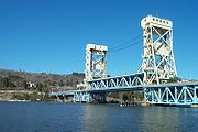
and the Portage Lake Lift Bridge from the west.
 The Portage Lake Lift Bridge connects the cities of Hancock
and Houghton, Michigan
by crossing over the Portage Waterway, an arm of Portage Lake which cuts across the Keweenaw Peninsula
with a canal linking the final several miles to Lake Superior
to the northwest.
As its name states, the bridge is a lift bridge
with the middle section capable of being lifted from its low point of four feet clearance over the water to a clearance of thirty two feet to allow boats to pass underneath. The Portage Lake Lift Bridge is the widest and heaviest double decked vertical lift bridge in the world. The lower deck of the bridge was originally open to rail traffic, but this level is now closed to trains and is used in the winter for snowmobile traffic. Throughout the 1960s, 70s and 80s, the bridge was painted the same color as the Mackinac Bridge — cream and forest green — however, in the early 1990s, it was repainted in a cream and robins egg blue color scheme—exactly the same colors as the National Park Service's ship Ranger III—to some demoting Houghton as the "Gateway to Isle Royale".
at the base of the Mt. Ripley Ski Area before turning north to Dollar Bay on the shore of the heavy polluted Torch Lake
. Next are the twin communities of Lake Linden
and Hubbell
. M-26 forms the main streets of these as it passes north from Hubbell into Lake Linden. The highway then runs back to the west to rejoin US 41 in Calumet
. US 41/M-26 connects with the northern end of M-203
on the north side of town before heading out to Keweenaw County
. In the town of Phoenix
, M-26 separates from US 41 one last time, turning west for a stretch along the northern shoreline of the Keweenaw Peninsula
. It passes through the communities of Eagle River
(county seat of Keweenaw County) and Eagle Harbor.
M-26 in Eagle River crosses the namesake river on a glue-laminated timber bridge. The 152 feet (46 m) bridge features two timber frame arches of 74 feet (23 m) and 79 feet (24 m) in length. The connecting work between the wood elements is steel. There are hinge points in the center of each arch. The deck is wood covered with an asphalt driving surface. Enough wood was used in construction to fabricate three or four average-sized homes. All the wood was pressure-treated, and the steel was galvanized and epoxy-coated. Reapplication of preservative and tighening bolts will be the routine maintenance required every three years.
Past Eagle Harbor, M-26 meets the highly scenic Brockway Mountain Drive
. The northern terminus of M-26 is located in Copper Harbor
. The terminus is just past the second intersection with Brockway Mountain Drive near the marina and the location of the Isle Royale Queen ferry to Isle Royale National Park
.
. Several turnouts along the route allow for views of Copper Harbor, Lake Superior and undeveloped woodland.
state line to a connection with STH-26
along what is now US 45.
The original northern terminus of M-26 was in Laurium
at M-15
(now US 41); it was extended by 1927 along US 41 to Mohawk and then replacing M-83
to Gay
. This extension would be reversed in 1933 when the Mohawk to Gay routing was turned over to Keweenaw County control. A second extension in 1935 along US 41 to Phoenix replaced M-129
between Phoenix and Eagle Harbor. At this time, M-206 was designated from M-26 to the Eagle Harbor light house. A rerouting of M-26 in November 1940 moved it between Phoenix and Eagle River, replacing M-111
. The segment between Phoenix and Eagle River along Copper Falls Mine Road was turned over to Keweenaw County at this time.
In 1979, M-26 was rerouted through Dakota Heights
, bisecting it. Park Avenue had formerly served as the main route from Houghton to Atlantic Mine, but this was replaced by the new route of the highway.
In 2006, the Michigan Department of Transportation
(MDOT) opened a bypass around the southwest and southern edge of South Range
in order to provide a safer route through the town. As of 4 October 2006, MDOT has transferred jurisdiction of the necessary pieces of roadway to complete the M-26 bypass of South Range.
routing in the Keweenaw Peninsula
that ran between Eagle River
and Phoenix
along what is, now, modern-day M-26 parallel to Eagle River
. That incarnation lasted two years until M-111 was deleted and M-26 was realigned over it. The M-111 designation has not been used since being deleted in 1940.
in Keweenaw County in 1935.
Michigan Highway System
The Michigan State Trunkline Highway System is made up of all the highways designated as Interstates, U.S. Highways and State Highways in the US state of Michigan. The system is maintained by the Michigan Department of Transportation and comprises of trunklines in all 83 counties of Michigan on...
in the U.S. state of Michigan
Michigan
Michigan is a U.S. state located in the Great Lakes Region of the United States of America. The name Michigan is the French form of the Ojibwa word mishigamaa, meaning "large water" or "large lake"....
, running from two miles (3 km) east of Rockland to its junction with US Highway 41
U.S. Route 41 in Michigan
US Highway 41 is a part of the United States Numbered Highway System that runs from Miami, Florida, to the Upper Peninsula of the US state of Michigan. In Michigan, it is a state trunkline highway that enters the state via the Interstate Bridge between Marinette, Wisconsin, and Menominee,...
(US 41) in Copper Harbor
Copper Harbor, Michigan
Copper Harbor is a small unincorporated community in northeastern Keweenaw County in the U.S. state of Michigan. It is within Grant Township on the Keweenaw Peninsula that juts from the Upper Peninsula of Michigan into Lake Superior.-History:...
. It generally runs southwest-to-northeast in the western half or Michigan's Upper Peninsula
Upper Peninsula of Michigan
The Upper Peninsula of Michigan is the northern of the two major land masses that make up the U.S. state of Michigan. It is commonly referred to as the Upper Peninsula, the U.P., or Upper Michigan. It is also known as the land "above the Bridge" linking the two peninsulas. The peninsula is bounded...
. The northernmost segment, which closely parallels the shore of Lake Superior
Lake Superior
Lake Superior is the largest of the five traditionally-demarcated Great Lakes of North America. It is bounded to the north by the Canadian province of Ontario and the U.S. state of Minnesota, and to the south by the U.S. states of Wisconsin and Michigan. It is the largest freshwater lake in the...
on the west side of the Keweenaw Peninsula
Keweenaw Peninsula
The Keweenaw Peninsula is the northern-most part of Michigan's Upper Peninsula. It projects into Lake Superior and was the site of the first copper boom in the United States. As of the 2000 census, its population was roughly 43,200...
, is highly scenic.
M-26 previously reached the Wisconsin
Wisconsin
Wisconsin is a U.S. state located in the north-central United States and is part of the Midwest. It is bordered by Minnesota to the west, Iowa to the southwest, Illinois to the south, Lake Michigan to the east, Michigan to the northeast, and Lake Superior to the north. Wisconsin's capital is...
border, but a section of the highway became US 45
U.S. Route 45 in Michigan
US Highway 45 is a part of the United States Numbered Highway System that runs from Mobile, Alabama, to the Upper Peninsula of the US state of Michigan. The highway forms a part of the state trunkline highway system that is maintained by the Michigan Department of Transportation . It enters the...
. Other changes on the northern end of M-26 incorporated highways that were previously numbered M-111 and M-206 in the Eagle Harbor and Eagle River
Eagle River, Michigan
Eagle River is an unincorporated community in the U.S. state of Michigan and is the county seat of Keweenaw County.The community is on M-26 on the north side of the Keweenaw Peninsula, which projects into Lake Superior. It is about 27 miles northeast of Houghton and is situated in the northwest...
area.
Route description
Southern terminus to Houghton
M-26 starts at an intersection with US 45U.S. Route 45 in Michigan
US Highway 45 is a part of the United States Numbered Highway System that runs from Mobile, Alabama, to the Upper Peninsula of the US state of Michigan. The highway forms a part of the state trunkline highway system that is maintained by the Michigan Department of Transportation . It enters the...
east of Rockland in Michigan's Ontonagon County
Ontonagon County, Michigan
-National protected areas:* Keweenaw National Historical Park * Ottawa National Forest -Demographics:As of the census of 2000, there were 7,818 people, 3,456 households, and 2,225 families residing in the county. The population density was 6 people per square mile . There were 5,404 housing units...
. From there it runs through the town of Mass City
Mass City, Michigan
Mass City is an unincorporated community in Ontonagon County, Michigan, United States. Mass City is located in Greenland Township along M-26, southeast of Ontonagon...
to the junction with M-38
M-38 (Michigan highway)
M-38 is an east–west state trunkline highway in the Upper Peninsula of the U.S. state of Michigan. Its west end starts in Ontonagon and runs east to Baraga, some apart. The highway crosses streams and rivers in forest lands and provides access to a casino...
east of Greenland. The two highways join for a short distance before M-26 separates turning northeast to Winona across the Houghton County
Houghton County, Michigan
-National protected areas:* Keweenaw National Historical Park * Ottawa National Forest -Demographics:As of the census of 2000, there were 36,016 people, 13,793 households, and 8,137 families residing in the county. The population density was 36 people per square mile . There were 17,748 housing...
line. In Twin Lakes M-26 passes the shores of the namesake lakes and Twin Lakes State Park
Twin Lakes State Park (Michigan)
Twin Lakes State Park is a state park in Houghton County, Michigan. It is located in the Elm River Township, Michigan along M-26.-Facilities:* Beach House* Boat Launch* Campground - 62 Sites, 1 Cabin* Picnic Area...
. M-26 passes through wooded, hilly terrain in western Houghton County. The segment of roadway in South Range
South Range, Michigan
South Range is a village in Adams Township, Houghton County in the U.S. state of Michigan. It is bordered on the east by the unincorporated community of Baltic. It is about five miles southwest of Houghton on M-26. The population was 727 at the 2000 census...
was recently realigned to smooth out curves in the roadway. From there north, M-26 runs generally downhill on approaching the western business district of Houghton
Houghton, Michigan
Houghton is a city in the U.S. state of Michigan's Upper Peninsula and largest city in the Copper Country on the Keweenaw Peninsula. As of the 2010 census, the city population was 7,708. It is the county seat of Houghton County...
and the Portage Lake Lift Bridge from the west.
Portage Lake Lift Bridge
Hancock, Michigan
Hancock is a city in Houghton County; the northernmost in the U.S. state of Michigan, located on the Keweenaw Peninsula, or, depending on terminology, Copper Island. The population was 4,634 at the 2010 census...
and Houghton, Michigan
Houghton, Michigan
Houghton is a city in the U.S. state of Michigan's Upper Peninsula and largest city in the Copper Country on the Keweenaw Peninsula. As of the 2010 census, the city population was 7,708. It is the county seat of Houghton County...
by crossing over the Portage Waterway, an arm of Portage Lake which cuts across the Keweenaw Peninsula
Keweenaw Peninsula
The Keweenaw Peninsula is the northern-most part of Michigan's Upper Peninsula. It projects into Lake Superior and was the site of the first copper boom in the United States. As of the 2000 census, its population was roughly 43,200...
with a canal linking the final several miles to Lake Superior
Lake Superior
Lake Superior is the largest of the five traditionally-demarcated Great Lakes of North America. It is bounded to the north by the Canadian province of Ontario and the U.S. state of Minnesota, and to the south by the U.S. states of Wisconsin and Michigan. It is the largest freshwater lake in the...
to the northwest.
As its name states, the bridge is a lift bridge
Lift bridge
A vertical-lift bridge or lift bridge is a type of movable bridge in which a span rises vertically while remaining parallel with the deck....
with the middle section capable of being lifted from its low point of four feet clearance over the water to a clearance of thirty two feet to allow boats to pass underneath. The Portage Lake Lift Bridge is the widest and heaviest double decked vertical lift bridge in the world. The lower deck of the bridge was originally open to rail traffic, but this level is now closed to trains and is used in the winter for snowmobile traffic. Throughout the 1960s, 70s and 80s, the bridge was painted the same color as the Mackinac Bridge — cream and forest green — however, in the early 1990s, it was repainted in a cream and robins egg blue color scheme—exactly the same colors as the National Park Service's ship Ranger III—to some demoting Houghton as the "Gateway to Isle Royale".
Hancock to Copper Harbor
On the north end of the bridge, M-26 turns east while US 41 turns west into Hancock. M-26 passes through RipleyRipley, Michigan
Ripley is a small, unincorporated community in Franklin Township situated upon a slope, just east of Hancock on M-26 and across the Portage Lake Canal from Houghton....
at the base of the Mt. Ripley Ski Area before turning north to Dollar Bay on the shore of the heavy polluted Torch Lake
Torch Lake (Houghton County, Michigan)
Torch Lake is approximately 2,700 acres lying mostly within Torch Lake Township and having portions within Osceola Township and Schoolcraft Township. The lake is fed by the Traprock River....
. Next are the twin communities of Lake Linden
Lake Linden, Michigan
Lake Linden is a village in Houghton County in the U.S. state of Michigan. The population was 1,081 at the 2000 census. The village is mostly within Schoolcraft Township, though a tiny portion lies in Torch Lake Township.-History:...
and Hubbell
Hubbell, Michigan
Hubbell is an unincorporated community in Houghton County in the U.S. state of Michigan. The U.S. Census Bureau has defined an area around the community as a Census-designated place for statistical purposes. As of the 2000 census, the CDP population was 1,105...
. M-26 forms the main streets of these as it passes north from Hubbell into Lake Linden. The highway then runs back to the west to rejoin US 41 in Calumet
Calumet, Michigan
Calumet is a village in Calumet Township, Houghton County, in the U.S. state of Michigan's Upper Peninsula, that was once at the center of the mining industry of the Upper Peninsula. Also known as Red Jacket, the village includes the Calumet Downtown Historic District, listed on the National...
. US 41/M-26 connects with the northern end of M-203
M-203 (Michigan highway)
M-203 is a north–south state trunkline highway in the Upper Peninsula of the US state of Michigan. It connects McLain State Park with US 41 on each end in Hancock and Calumet...
on the north side of town before heading out to Keweenaw County
Keweenaw County, Michigan
-Demographics:As of the census of 2000, there were 2,301 people, 998 households, and 604 families residing in the county. The population density was 4 people per square mile . There were 2,327 housing units at an average density of 4 per square mile...
. In the town of Phoenix
Phoenix, Michigan
Phoenix is an unincorporated community in Keweenaw County, Michigan, United States. Phoenix lies at the junction of M-26 and US 41. Phoenix lies about two miles south of Eagle River, Michigan, near the shores of Lake Superior.-Copper:...
, M-26 separates from US 41 one last time, turning west for a stretch along the northern shoreline of the Keweenaw Peninsula
Keweenaw Peninsula
The Keweenaw Peninsula is the northern-most part of Michigan's Upper Peninsula. It projects into Lake Superior and was the site of the first copper boom in the United States. As of the 2000 census, its population was roughly 43,200...
. It passes through the communities of Eagle River
Eagle River, Michigan
Eagle River is an unincorporated community in the U.S. state of Michigan and is the county seat of Keweenaw County.The community is on M-26 on the north side of the Keweenaw Peninsula, which projects into Lake Superior. It is about 27 miles northeast of Houghton and is situated in the northwest...
(county seat of Keweenaw County) and Eagle Harbor.
M-26 in Eagle River crosses the namesake river on a glue-laminated timber bridge. The 152 feet (46 m) bridge features two timber frame arches of 74 feet (23 m) and 79 feet (24 m) in length. The connecting work between the wood elements is steel. There are hinge points in the center of each arch. The deck is wood covered with an asphalt driving surface. Enough wood was used in construction to fabricate three or four average-sized homes. All the wood was pressure-treated, and the steel was galvanized and epoxy-coated. Reapplication of preservative and tighening bolts will be the routine maintenance required every three years.
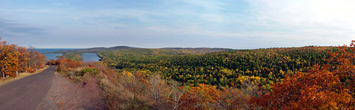
Past Eagle Harbor, M-26 meets the highly scenic Brockway Mountain Drive
Brockway Mountain Drive
Brockway Mountain Drive is a scenic highway just west of Copper Harbor in the Upper Peninsula of Michigan in the United States. Drivers can access the road from state highway M-26 on either end near Eagle Harbor to the west or Copper Harbor to the east in the Keweenaw Peninsula...
. The northern terminus of M-26 is located in Copper Harbor
Copper Harbor, Michigan
Copper Harbor is a small unincorporated community in northeastern Keweenaw County in the U.S. state of Michigan. It is within Grant Township on the Keweenaw Peninsula that juts from the Upper Peninsula of Michigan into Lake Superior.-History:...
. The terminus is just past the second intersection with Brockway Mountain Drive near the marina and the location of the Isle Royale Queen ferry to Isle Royale National Park
Isle Royale National Park
Isle Royale National Park is a U.S. National Park in the state of Michigan. Isle Royale, the largest island in Lake Superior, is over 45 miles in length and 9 miles wide at its widest point. The park is made of Isle Royale itself and approximately 400 smaller islands, along with any submerged...
.
Brockway Mountain Drive
Brockway Mountain Drive is a scenic route just west of Copper Harbor off M-26. The drive climbs to a height of 1328 feet (405 m) above sea level, 726 feet (221 m) above the surface of Lake SuperiorLake Superior
Lake Superior is the largest of the five traditionally-demarcated Great Lakes of North America. It is bounded to the north by the Canadian province of Ontario and the U.S. state of Minnesota, and to the south by the U.S. states of Wisconsin and Michigan. It is the largest freshwater lake in the...
. Several turnouts along the route allow for views of Copper Harbor, Lake Superior and undeveloped woodland.
History
Before it was a state highway, many parts of the original route of M-26 was used as a military road, connecting Fort Wilkins at Copper Harbor with Fort Howard at Green Bay, Wisconsin. From 1919 until 1934, M-26 was routed southward to the WisconsinWisconsin
Wisconsin is a U.S. state located in the north-central United States and is part of the Midwest. It is bordered by Minnesota to the west, Iowa to the southwest, Illinois to the south, Lake Michigan to the east, Michigan to the northeast, and Lake Superior to the north. Wisconsin's capital is...
state line to a connection with STH-26
Highway 26 (Wisconsin)
State Trunk Highway 26 is a state highway in the U.S. state of Wisconsin. The route is generally two-lane with the exception of a few urban multi-lane arterials...
along what is now US 45.
The original northern terminus of M-26 was in Laurium
Laurium, Michigan
Laurium is a village in Calumet Township, Houghton County in the U.S. state of Michigan, in the center of the Keweenaw Peninsula. The population was 2,126 at the 2000 census.-History:...
at M-15
M-15 (Michigan highway)
M-15 is a north–south state trunkline highway in the US state of Michigan. The southern terminus is a junction with US Highway 24 just south of Clarkston on the northwestern edge of the Detroit metropolitan area. The trunkline is a recreational route running north and northwest to the...
(now US 41); it was extended by 1927 along US 41 to Mohawk and then replacing M-83
M-83 (Michigan highway)
M-83 is a state trunkline in the Lower Peninsula of the US state of Michigan primarily serving as a link between I-75/US 23 and the Bavarian themed town of Frankenmuth known for Bronner's Christmas Wonderland, Zehnder's and the Bavarian Inn.-Route description:...
to Gay
Gay, Michigan
Gay is an unincorporated community in Keweenaw County in the U.S. state of Michigan. It is 12 miles from Lake Linden on Copper Island at the western end of the Upper Peninsula. Local government is provided by Sherman Township. As of 2000, its population is 60....
. This extension would be reversed in 1933 when the Mohawk to Gay routing was turned over to Keweenaw County control. A second extension in 1935 along US 41 to Phoenix replaced M-129
M-129 (Michigan highway)
M-129 is a state trunkline highway in the Upper Peninsula of the US state of Michigan. It runs from Cedarville to Sault Ste. Marie. South of Nine Mile Road in Chippewa County , M-129 overlays the Michigan Meridian. The section of M-129 that overlays the meridian is named Meridian Road...
between Phoenix and Eagle Harbor. At this time, M-206 was designated from M-26 to the Eagle Harbor light house. A rerouting of M-26 in November 1940 moved it between Phoenix and Eagle River, replacing M-111
M-111 (Michigan highway)
M-111 was the designation given to two former state trunklines in the U.S. state of Michigan:*M-111 in the Bay City area*M-111 in Keweenaw County...
. The segment between Phoenix and Eagle River along Copper Falls Mine Road was turned over to Keweenaw County at this time.
In 1979, M-26 was rerouted through Dakota Heights
Dakota Heights, Michigan
Dakota Heights is an unincorporated community in Portage Township, Houghton County in the U.S. state of Michigan. It is an enclave surrounded on all four sides by the extreme western part of the city of Houghton Dakota Heights is an unincorporated community in Portage Township, Houghton County in...
, bisecting it. Park Avenue had formerly served as the main route from Houghton to Atlantic Mine, but this was replaced by the new route of the highway.
In 2006, the Michigan Department of Transportation
Michigan Department of Transportation
The Michigan Department of Transportation is a constitutional government agency in the US state of Michigan. The primary purpose of MDOT is to maintain the Michigan State Trunkline Highway System which includes all Interstate, US and state highways in Michigan with the exception of the Mackinac...
(MDOT) opened a bypass around the southwest and southern edge of South Range
South Range, Michigan
South Range is a village in Adams Township, Houghton County in the U.S. state of Michigan. It is bordered on the east by the unincorporated community of Baltic. It is about five miles southwest of Houghton on M-26. The population was 727 at the 2000 census...
in order to provide a safer route through the town. As of 4 October 2006, MDOT has transferred jurisdiction of the necessary pieces of roadway to complete the M-26 bypass of South Range.
M-111
After 1938, the M-111 designation was given to an old M-6M-6 (Michigan highway)
M-6, or the Paul B. Henry Freeway, is a freeway and state trunkline highway in the United States that serves portions of southern Kent and eastern Ottawa counties south of Grand Rapids, Michigan. Although the freeway is named for Paul B. Henry, local residents and the press continue to use the...
routing in the Keweenaw Peninsula
Keweenaw Peninsula
The Keweenaw Peninsula is the northern-most part of Michigan's Upper Peninsula. It projects into Lake Superior and was the site of the first copper boom in the United States. As of the 2000 census, its population was roughly 43,200...
that ran between Eagle River
Eagle River, Michigan
Eagle River is an unincorporated community in the U.S. state of Michigan and is the county seat of Keweenaw County.The community is on M-26 on the north side of the Keweenaw Peninsula, which projects into Lake Superior. It is about 27 miles northeast of Houghton and is situated in the northwest...
and Phoenix
Phoenix, Michigan
Phoenix is an unincorporated community in Keweenaw County, Michigan, United States. Phoenix lies at the junction of M-26 and US 41. Phoenix lies about two miles south of Eagle River, Michigan, near the shores of Lake Superior.-Copper:...
along what is, now, modern-day M-26 parallel to Eagle River
Eagle River (Michigan)
The Eagle River is a small river on the Keweenaw Peninsula of the U.S. state of Michigan. The river flows into Lake Superior in the community of Eagle River...
. That incarnation lasted two years until M-111 was deleted and M-26 was realigned over it. The M-111 designation has not been used since being deleted in 1940.
M-206
M-206 was a state highway that served as a spur route from M-26 into Eagle Harbor and the Eagle Harbor LighthouseEagle Harbor Lighthouse
Eagle Harbor Light is a lighthouse near Eagle Harbor Township, Michigan on the Keewenaw Peninsula jutting from the Michigan's Upper Peninsula up into Lake Superior. This area of Michigan is often referred to as Copper Country, and sometimes as Copper Island...
in Keweenaw County in 1935.