
.gif)
M-22 (Michigan highway)
Encyclopedia
M-22 is a state trunkline highway
in the US state of Michigan
. It is 116.651 miles (187.731 km) long and follows the Lake Michigan
shoreline of the Leelanau Peninsula
, making up a portion of the Lake Michigan Circle Tour. It also passes through the Sleeping Bear Dunes National Lakeshore
. The highway is U-shaped as it rounds the peninsula running through tourist areas in Leland
and Suttons Bay
in addition to the national park.
M-22 is an original trunkline designation dating back to the 1919 designation of the system. Reroutings have moved the highway closer to the water between Suttons Bay and Traverse City. A section of the highway used temporarily even was used for another highway, M-109
. The highway was also named a Michigan Heritage Route
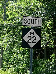
. The route marker shield is used in marketing by a local business as a symbol of the region.
 The southern terminus is 3 miles (5 km) northeast of Manistee
and the northern terminus is in Traverse City
. In between the trunkline loops north along Lake Michigan
to Northport
before turning south along the West Arm of Grand Traverse Bay
. The road itself comprises numerous turns and hills, making it a very popular drive for tourists visiting the area from areas such as Chicago and Detroit, especially during autumn. The road runs north to the village of Onekama
running east and north of Portage Lake before returning north to Arcadia. M-22 turns northeasterly to curve around the north shore of Crystal Lake after passing through Elberta
and Frankfort
. South of the Platte River, the highway crosses into the Sleeping Bear Dunes National Lakeshore
. East of Platte Lake, M-22 turns northward again toward Empire, headquarters of the national park. M-22 takes the inland route between Little and Big Glen lakes, losing the Lake Michigan Circle Tour designation to M-109
until the two meet again in Glen Arbor. The roadway follows the shoreline of Pyramid Point and passes east out of the national park before turning north to Leland
.
Leland is home to Fishtown, and the ferries to the Manitou Islands off the coast of the Leelanau Peninsula. Continuing northward, M-22 reaches its northernmost extent in Northport before turning south. It passes through the reservation of the Grand Traverse Band of Chippewa and Ottawa Indians in Peshawbestown
, home to one of the tribe's two casinos. Further south is the community of Suttons Bay
located on the small bay of the same name. From here south, the highway runs just off the shore of the Grand Traverse Bay south to Greilickville
. Just south of Greilickville, M-22 enters a section of the city of Traverse City that's located in Leelanau County, Michigan
formed by an acquisition of a neighborhood of Greilickville. Here is the eastern junction between M-22 and M-72
. The two highways run concurrently
along Grandview Parkway to Division Street. There they meet US 31
/M-37
and M-22 ends. A portion of this road has been designated a scenic heritage
route by the state of Michigan.
Until 1936, M-22's route was on Cherry Bend and Center Rds. in Leelanau County to Suttons Bay. At that time, M-22 was relocated along the west arm of Grand Traverse Bay
onto Center Rd. up to Crain Hill Rd. In 1949, M-22 was relocated the rest of the way to Suttons Bay, and the former M-22 on Cherry Bend and Center Rds. became County Rd. 633. and in 1945, the last gravel stretch of M-22 from Leland to Northport was paved.
In Traverse City, M-22 originally started at Front and Union Sts. going west on Front to Elmwood, turning north onto Elmwood, then west on Bay St. to Greilickville
. It was relocated onto the newly built Grand View Parkway in 1952, from Greilickville to Division St. (relocated US 31).
Michigan Highway System
The Michigan State Trunkline Highway System is made up of all the highways designated as Interstates, U.S. Highways and State Highways in the US state of Michigan. The system is maintained by the Michigan Department of Transportation and comprises of trunklines in all 83 counties of Michigan on...
in the US state of Michigan
Michigan
Michigan is a U.S. state located in the Great Lakes Region of the United States of America. The name Michigan is the French form of the Ojibwa word mishigamaa, meaning "large water" or "large lake"....
. It is 116.651 miles (187.731 km) long and follows the Lake Michigan
Lake Michigan
Lake Michigan is one of the five Great Lakes of North America and the only one located entirely within the United States. It is the second largest of the Great Lakes by volume and the third largest by surface area, after Lake Superior and Lake Huron...
shoreline of the Leelanau Peninsula
Leelanau Peninsula
The Leelanau Peninsula is a peninsula of the U.S. state of Michigan that extends about from the Lower Peninsula of Michigan into Lake Michigan. Leelanau County encompasses the entire peninsula. It is often referred to as the "little finger" of the mitten-shaped lower peninsula.Sleeping Bear Dunes...
, making up a portion of the Lake Michigan Circle Tour. It also passes through the Sleeping Bear Dunes National Lakeshore
Sleeping Bear Dunes National Lakeshore
Sleeping Bear Dunes National Lakeshore is a United States National Lakeshore located along the northwest coast of the Lower Peninsula of Michigan in Leelanau County and Benzie County....
. The highway is U-shaped as it rounds the peninsula running through tourist areas in Leland
Leland, Michigan
Leland is an unincorporated community in the U.S. state of Michigan. It was the county seat of Leelanau County from 1883 to 2008, when a new government center was completed in Suttons Bay Township, closer to the county's geographic center....
and Suttons Bay
Suttons Bay, Michigan
Suttons Bay is a village in Leelanau County in the U.S. state of Michigan. The population was 589 at the 2000 census. The village was incorporated in 1898 and is located within Suttons Bay Township....
in addition to the national park.
M-22 is an original trunkline designation dating back to the 1919 designation of the system. Reroutings have moved the highway closer to the water between Suttons Bay and Traverse City. A section of the highway used temporarily even was used for another highway, M-109
M-109 (Michigan highway)
M-109 is the designation of a state trunkline highway in the Lower Peninsula of the US state of Michigan that runs between Empire and Glen Arbor...
. The highway was also named a Michigan Heritage Route
Michigan Heritage Route
Michigan Heritage Route is a designation for roads in Michigan. The designation was created by the state legislature in 1993.The program emphasizes cooperation among local residents, government officials, landowners and interested groups to preserve unique scenic, historic or recreational...
. The route marker shield is used in marketing by a local business as a symbol of the region.
Route description
Manistee, Michigan
Manistee is a city in the U.S. state of Michigan. As of the 2000 census, the city population was 6,586. It is the county seat of Manistee County. The name "Manistee" is from an Ojibwe word first applied to the principal river of the county. The derivation is not certain, but it may be from...
and the northern terminus is in Traverse City
Traverse City, Michigan
Traverse City is a city in the U.S. state of Michigan. It is the county seat of Grand Traverse County, although a small portion extends into Leelanau County. It is the largest city in the 21-county Northern Michigan region. The population was 14,674 at the 2010 census, with 143,372 in the Traverse...
. In between the trunkline loops north along Lake Michigan
Lake Michigan
Lake Michigan is one of the five Great Lakes of North America and the only one located entirely within the United States. It is the second largest of the Great Lakes by volume and the third largest by surface area, after Lake Superior and Lake Huron...
to Northport
Northport, Michigan
Northport is a village in Leelanau Township, Leelanau County in the U.S. state of Michigan. The population was 648 at the 2000 census. When Leelanau County was formed in 1863, Northport served as the first county seat from 1863 to 1883.-Geography:...
before turning south along the West Arm of Grand Traverse Bay
Grand Traverse Bay
Grand Traverse Bay is a bay of Lake Michigan formed by part of Northern Michigan. The bay is long, 10 miles wide, and up to deep in spots. It is divided into two arms by the Old Mission Peninsula...
. The road itself comprises numerous turns and hills, making it a very popular drive for tourists visiting the area from areas such as Chicago and Detroit, especially during autumn. The road runs north to the village of Onekama
Onekama, Michigan
Onekama is a village in Manistee County in the U.S. state of Michigan. The population was 647 at the 2000 census. The village is located on the shores of Portage Lake and is surrounded by Onekama Township. The town's name is derived from "oneka-ma-engh", a native phrase for "portage"...
running east and north of Portage Lake before returning north to Arcadia. M-22 turns northeasterly to curve around the north shore of Crystal Lake after passing through Elberta
Elberta, Michigan
Elberta is a village in Benzie County in the U.S. state of Michigan. The population was 457 at the 2000 census. The village located in the east of Gilmore Township, on the south side of Lake Betsie, which is formed by the Betsie River before flowing into Lake Michigan. The village is on M-22 just...
and Frankfort
Frankfort, Michigan
Frankfort is a city in Benzie County in the U.S. state of Michigan. The population was 1,513 at the 2000 census. The elevation of Frankfort is above sea level. The city is situated with Lake Michigan to the west, Lake Betsie, formed by the Betsie River before flowing into Lake Michigan, on the...
. South of the Platte River, the highway crosses into the Sleeping Bear Dunes National Lakeshore
Sleeping Bear Dunes National Lakeshore
Sleeping Bear Dunes National Lakeshore is a United States National Lakeshore located along the northwest coast of the Lower Peninsula of Michigan in Leelanau County and Benzie County....
. East of Platte Lake, M-22 turns northward again toward Empire, headquarters of the national park. M-22 takes the inland route between Little and Big Glen lakes, losing the Lake Michigan Circle Tour designation to M-109
M-109 (Michigan highway)
M-109 is the designation of a state trunkline highway in the Lower Peninsula of the US state of Michigan that runs between Empire and Glen Arbor...
until the two meet again in Glen Arbor. The roadway follows the shoreline of Pyramid Point and passes east out of the national park before turning north to Leland
Leland, Michigan
Leland is an unincorporated community in the U.S. state of Michigan. It was the county seat of Leelanau County from 1883 to 2008, when a new government center was completed in Suttons Bay Township, closer to the county's geographic center....
.
Leland is home to Fishtown, and the ferries to the Manitou Islands off the coast of the Leelanau Peninsula. Continuing northward, M-22 reaches its northernmost extent in Northport before turning south. It passes through the reservation of the Grand Traverse Band of Chippewa and Ottawa Indians in Peshawbestown
Peshawbestown, Michigan
Peshawbestown is an unincorporated community in Suttons Bay Township of Leelanau in the U.S. state of Michigan. In historical documents, the name is spelled variously as Peshabetown, Peshabatown, Pshawbatown, Preshabestown....
, home to one of the tribe's two casinos. Further south is the community of Suttons Bay
Suttons Bay, Michigan
Suttons Bay is a village in Leelanau County in the U.S. state of Michigan. The population was 589 at the 2000 census. The village was incorporated in 1898 and is located within Suttons Bay Township....
located on the small bay of the same name. From here south, the highway runs just off the shore of the Grand Traverse Bay south to Greilickville
Greilickville, Michigan
Greilickville is an unincorporated community in Leelanau County in the U.S. state of Michigan. It is a census-designated place used for statistical purposes and has no legal standing as a municipality. The population was 1,415 at the 2000 census....
. Just south of Greilickville, M-22 enters a section of the city of Traverse City that's located in Leelanau County, Michigan
Leelanau County, Michigan
-History:The county's name is said to be a Native American word meaning "delight of life", but it is a neologism made up by Indian agent and ethnographer Henry Schoolcraft, who sometimes gave the name "Leelinau" to Native American women in his tales. He created many faux Indian place names in...
formed by an acquisition of a neighborhood of Greilickville. Here is the eastern junction between M-22 and M-72
M-72 (Michigan highway)
M-72 is a state trunkline highway in the US state of Michigan, running from Lake Huron to Lake Michigan across the northern part of the Lower Peninsula. The highway connects M-22 in Empire with US Highway 23 in Harrisville. It is one of only three Michigan state trunklines that cross the Lower...
. The two highways run concurrently
Concurrency (road)
A concurrency, overlap, or coincidence in a road network is an instance of one physical road bearing two or more different highway, motorway, or other route numbers...
along Grandview Parkway to Division Street. There they meet US 31
U.S. Route 31 in Michigan
US Highway 31 is a part of the United States Numbered Highway System that runs from Alabama, to the Upper Peninsula of the US state of Michigan. In Michigan, it is a state trunkline highway that runs from the Indiana–Michigan state line at Bertrand Township to its terminus at Interstate 75 south...
/M-37
M-37 (Michigan highway)
M-37 is a north–south state trunkline highway in the US state of Michigan. The southern terminus is near the border between Kalamazoo and Calhoun counties at exit 92 of Interstate 94 southwest of Battle Creek. The northern terminus is at the Mission Point Light on Old Mission Point in Grand...
and M-22 ends. A portion of this road has been designated a scenic heritage
Michigan Heritage Route
Michigan Heritage Route is a designation for roads in Michigan. The designation was created by the state legislature in 1993.The program emphasizes cooperation among local residents, government officials, landowners and interested groups to preserve unique scenic, historic or recreational...
route by the state of Michigan.
History
M-22 is an original trunkline, dating to the 1919 signing of the system. In 1929, the highway was rerouted along the west side of Big Glen Lake, using the modern M-109 around the lake. M-22 would be rerouted back around to the present routing and M-109 formed on the west side of the lake.Until 1936, M-22's route was on Cherry Bend and Center Rds. in Leelanau County to Suttons Bay. At that time, M-22 was relocated along the west arm of Grand Traverse Bay
Grand Traverse Bay
Grand Traverse Bay is a bay of Lake Michigan formed by part of Northern Michigan. The bay is long, 10 miles wide, and up to deep in spots. It is divided into two arms by the Old Mission Peninsula...
onto Center Rd. up to Crain Hill Rd. In 1949, M-22 was relocated the rest of the way to Suttons Bay, and the former M-22 on Cherry Bend and Center Rds. became County Rd. 633. and in 1945, the last gravel stretch of M-22 from Leland to Northport was paved.
In Traverse City, M-22 originally started at Front and Union Sts. going west on Front to Elmwood, turning north onto Elmwood, then west on Bay St. to Greilickville
Greilickville, Michigan
Greilickville is an unincorporated community in Leelanau County in the U.S. state of Michigan. It is a census-designated place used for statistical purposes and has no legal standing as a municipality. The population was 1,415 at the 2000 census....
. It was relocated onto the newly built Grand View Parkway in 1952, from Greilickville to Division St. (relocated US 31).