
.gif)
M-185 (Michigan highway)
Encyclopedia
M-185 is a state trunkline highway
in the U.S. state of Michigan
that circles Mackinac Island
, a popular tourist destination on the Lake Huron
side of the Straits of Mackinac
, along the island's shoreline. A narrow paved road of 8.004 miles (12.9 km), it offers scenic views of the straits that divide the Upper
and the Lower
peninsulas of Michigan and Lakes Huron and Michigan
. It has no connection to any other Michigan state trunkline highways—as it is on an island—and is accessible only by passenger ferry. The City of Mackinac Island
, which shares jurisdiction over the island with the Mackinac Island State Park Commission
(MISPC), calls the highway Main Street within the built-up area on the island's southeast quadrant, and Lake Shore Road elsewhere. M-185 passes by several key sites within Mackinac Island State Park
, including Fort Mackinac
, Arch Rock
, British Landing
, and Devil's Kitchen
. Lake Shore Road carries the highway next to the Lake Huron shoreline, running between the water's edge and woodlands outside of the downtown area.
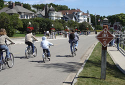
According to the Michigan Department of Transportation
(MDOT), M-185 is "the only state highway in the nation where motor vehicles are banned". These restrictions on automobiles date back to the 1890s, and since the ban, only a few vehicles have been permitted on the island other than the city's emergency vehicles. The highway was built during the first decade of the 20th century by the state and designated as a state highway in 1933. The highway was paved in the 1950s, and portions were rebuilt to deal with shoreline erosion in the 1980s. Until 2005, it was the only state highway without any automobile accidents.
Visitor Center. The highway uses wooden markers to measure miles instead of the common metal signage; these signs are erected by the MISPC, as MDOT does not install the standard state highway reassurance markers
along this roadway. M-185 is one of only three state trunkline highways in Michigan on islands; the others are M-134
on Drummond Island and M-154
on Harsens Island
. No part of M-185 has been listed on the National Highway System
, a network of roadways important to the country's economy, defense, and mobility. Over a half million people travel along the trunkline in a year.
Mackinac Island has been a tourist destination since the late 19th century. M-185 is recognized in the press for its unique role as the only state highway without car traffic in the United States by such papers as The Kansas City Star
, the Chicago Tribune
, and the Toronto Star
. In 2003, it was named the "best scenic drive" in the state by The Detroit News
. In 2008, USA Today
named the island one of the "10 great places to get your feet back on the ground" as a car-free destination, highlighting the unique status of M-185 in the process. The magazine Paraplegia News, in an article encouraging its readers to visit Mackinac Island, called the trek around the island on M-185 a "high priority" for visitors. The trip around the island "provides a photo opportunity at every bend in the path", according to the PSA Journal, the official magazine of the Photographic Society of America
.
 The beginning and ending of M-185 is marked at the intersection of Main and Fort streets next to the visitor center. That building is operated by the MISPC, but it was originally a US Coast Guard station. From its starting point, M-185 heads east between Marquette Park
, at the base of Fort Mackinac, and the marina at Haldimand Bay. The roadway passes the Indian Dormitory
(Mackinac Art Center), as well as various hotels, bed and breakfast establishments, private residences and landmarks such as Sainte Anne's Catholic Church, Mission Church
and the Mission House
. Main Street then turns northeasterly, passing Mission Point Resort (the former Mackinac College
), after which the road name changes to Lake Shore Road. Along this section of the trunkline, Shoreline Trail departs to the south and follows the water's edge before returning to M-185 at the city's water filtration plant.
viewing area just beyond the mile 1 marker. The next two miles (3.2 km) of M-185 are relatively isolated and devoid of major landmarks as the highway rounds Hennepin Point and runs along Voyageur's Bay. Other than a few picnic tables, the only feature between Arch Rock and mile 3 is the Lake Shore Nature Trail, a short interpretive trail on the inland side of the road. Just beyond mile 3, Scott's Shore Road, a short gravel-surfaced connecting roadway between Lake Shore Road and Scott's Road, departs inland near Point St. Clair. M-185 is bounded by the interior woods on one side and the beaches and rocky shores on the other through this area.
Mile 4 is situated at Point aux Pins at the northernmost point of the island. Here, M-185 turns southerly, passing the state boat dock and a nature center before coming to British Landing
at the intersection with British Landing Road. The area is a popular stopping point for tourists biking or walking M-185; it is the location where British troops came ashore during the Battle of Mackinac Island
during the War of 1812
. Located around British Landing are various amenities including restrooms, picnic tables, and a concession stand. M-185 continues along Maniboajo Bay and passes the mile 5 marker near Radisson Point.
The next area along M-185 is also sparsely developed as it passes along Griffin Cove. Other than a few newer residential developments, the sights are limited to Brown's Brook, which features a picnic area and interpretive nature trial, and the views of the Mackinac Bridge
as the trunkline rounds both Heriot and Perrot points. Between the markers for miles 6 and 7 is the Devil's Kitchen
, another popular tourist stopping point, at Jacker Point. Near mile 7 is the West Bluff Stairs leading up the bluff to Pontiac's Lookout. Further along, there is a marker commemorating the filming of a scene from Somewhere in Time
as well as views of the Grand Hotel
. The building's 660 feet (201.2 m) front porch is promoted as the "longest in the world". Visible to the east of the hotel is Michigan's second Governor's Mansion, which is used as a summer retreat for the state's chief executive. At this point, M-185 transitions back to the more developed portion of the island and the road name for the route changes back to Main Street. Next to the roadway, a boardwalk runs from here into the downtown business district.
. As it passes the island's public library on the shoreline side of the street, Main Street makes a sweeping curve to the north at Windermere, or Biddle's Point, to run through the downtown district. Other than the library, most of the city's public buildings are actually situated along Market Street, one block behind Main Street. Three streets and a city park allow for connections between Main and Market streets. M-185 through downtown Mackinac Island passes through the major business district, featuring dozens of shops, restaurants and lodging establishments; nearly a dozen of these outlets, feature the authentic Mackinac Island fudge made fresh daily during tourist season. The passenger ferry docks are all situated along Main Street in the downtown area. At the northeastern end of the downtown district, Main Street intersects Fort Street at the state park visitor center to complete its circuit of Mackinac Island.
Lake Shore Road around the island was built between 1900 and 1910 by the state, and the M-185 designation was first assigned on July 12, 1933. The roadway was purpose-built for non-motorized use; it is narrower than other state highways. During the 1950s, the state paved the road in asphalt
. Since the 1970s, the MISPC has allowed snowmobiles to operate on Mackinac Island during the winter.
In the mid-1980s, rising water levels in Lake Huron endangered M-185 and bicyclists. The roadway was overwashed by waves from the lake during a storm on May 31, 1985; the waves littered the road with gravel and dirt and raised fears of erosion. MDOT spent around $50,000 to install 2500 ST (2,232.1 LT; 2,268 t) of rock and filter cloth designed to prevent erosion. The expectation at the time was that Lake Huron could rise another 4–5 in (10.2–12.7 cm) that summer. Such a lake level increase prompted worries that the waves would wash away sections of the road. The lake had already washed away shoreline near Arch Rock; there was at least 8 feet (2.4 m) of berm between the road and shoreline in the 1970s and by 1985 some sections had been reduced to just 2 inches (5.1 cm). Storms later that year washed away sections of M-185, removing huge chunks of asphalt. MDOT closed those stretches on July 7, 1986, after the Independence Day
weekend, to fix the damage. Repairs were budgeted to replace the missing sections of roadway at a cost of $894,366; tourists were detoured inland, and uphill, to access the island's various tourist attractions.
In 1979, while filming Somewhere in Time, a car was brought on the island for Christopher Reeve
's character to drive. The next time that a vehicle was permitted on the island was on July 6, 1998, to commemorate the original ordinance that prohibited cars from Mackinac Island. A 1901 Geneva steam-powered car toured the island and was exhibited in Marquette Park before being towed by horse back to British Landing. The only known motor vehicle collision on Mackinac Island occurred on M-185 at the head of the Shepler passenger ferry dock on May 13, 2005, when the island's fire truck slightly damaged the door on the island's ambulance; both vehicles were responding to a report from the ferryboat that an injured passenger required medical attention. Before this incident, it was the only state highway that "never had an automobile accident" according to the Toronto Star
.
, which is located in Mackinac County
. Milemarkers are posted in a counterclockwise fashion.
Michigan Highway System
The Michigan State Trunkline Highway System is made up of all the highways designated as Interstates, U.S. Highways and State Highways in the US state of Michigan. The system is maintained by the Michigan Department of Transportation and comprises of trunklines in all 83 counties of Michigan on...
in the U.S. state of Michigan
Michigan
Michigan is a U.S. state located in the Great Lakes Region of the United States of America. The name Michigan is the French form of the Ojibwa word mishigamaa, meaning "large water" or "large lake"....
that circles Mackinac Island
Mackinac Island
Mackinac Island is an island and resort area covering in land area, part of the U.S. state of Michigan. It is located in Lake Huron, at the eastern end of the Straits of Mackinac, between the state's Upper and Lower Peninsulas. The island was home to a Native American settlement before European...
, a popular tourist destination on the Lake Huron
Lake Huron
Lake Huron is one of the five Great Lakes of North America. Hydrologically, it comprises the larger portion of Lake Michigan-Huron. It is bounded on the east by the Canadian province of Ontario and on the west by the state of Michigan in the United States...
side of the Straits of Mackinac
Straits of Mackinac
The Straits of Mackinac is the strip of water that connects two of the Great Lakes, Lake Michigan and Lake Huron, and separates the Lower Peninsula of Michigan from the Upper Peninsula of Michigan. It is a shipping lane providing passage for raw materials and finished goods, connecting, for...
, along the island's shoreline. A narrow paved road of 8.004 miles (12.9 km), it offers scenic views of the straits that divide the Upper
Upper Peninsula of Michigan
The Upper Peninsula of Michigan is the northern of the two major land masses that make up the U.S. state of Michigan. It is commonly referred to as the Upper Peninsula, the U.P., or Upper Michigan. It is also known as the land "above the Bridge" linking the two peninsulas. The peninsula is bounded...
and the Lower
Lower Peninsula of Michigan
The Lower Peninsula of Michigan is the southern of the two major landmasses of the U.S. state of Michigan. It is surrounded by water on all sides except its southern border, which it shares with Ohio and Indiana. Geographically, the Lower Peninsula has a recognizable shape that many people...
peninsulas of Michigan and Lakes Huron and Michigan
Lake Michigan
Lake Michigan is one of the five Great Lakes of North America and the only one located entirely within the United States. It is the second largest of the Great Lakes by volume and the third largest by surface area, after Lake Superior and Lake Huron...
. It has no connection to any other Michigan state trunkline highways—as it is on an island—and is accessible only by passenger ferry. The City of Mackinac Island
Mackinac Island, Michigan
Mackinac Island is a city in Mackinac County in the U.S. state of Michigan. In the 2010 census, the city had a permanent population of 492, although there are thousands more seasonal workers and tourists during the summer months. From 1818–1882, the city was the county seat of the former...
, which shares jurisdiction over the island with the Mackinac Island State Park Commission
Mackinac Island State Park Commission
The Mackinac Island State Park Commission is an appointed board of the State of Michigan that administers state parklands in the Straits of Mackinac area. It performs public activities under the name Mackinac State Historic Parks...
(MISPC), calls the highway Main Street within the built-up area on the island's southeast quadrant, and Lake Shore Road elsewhere. M-185 passes by several key sites within Mackinac Island State Park
Mackinac Island State Park
Mackinac Island State Park is a state park located on Mackinac Island in the U.S. state of Michigan. The island park encompasses 2.81 mi² , which is approximately 74% of the island's total area of 3.78 mi² . The park is also within the boundaries of the city of Mackinac Island and has permanent...
, including Fort Mackinac
Fort Mackinac
Fort Mackinac is a former American military outpost garrisoned from the late 18th century to the late 19th century near Michilimackinac, Michigan, on Mackinac Island...
, Arch Rock
Arch Rock (Mackinac Island)
Arch Rock is a geologic formation on Mackinac Island in Michigan. It is a natural limestone arch formed during the Nipissing post-glacial period, a period of high Lake Huron levels following the end of the Wisconsin glaciation...
, British Landing
British Landing
British Landing is a place within Mackinac Island, Michigan and is located on the shore of Mackinac Island, two miles northwest of the island's downtown and harbor. British Landing is the site of a War of 1812 amphibious operation on July 16-17, 1812, by a joint force of the British Army and...
, and Devil's Kitchen
Devil's Kitchen (cave)
Devil's Kitchen is a small cave on the southwestern shore of Mackinac Island in Michigan, USA. The cave was carved during the Nipissing post-glacial period by the waters of Lake Huron. It consists of two wave-cut hollows in a rocky cliff, one directly on top of the other.Mackinac Island's...
. Lake Shore Road carries the highway next to the Lake Huron shoreline, running between the water's edge and woodlands outside of the downtown area.
According to the Michigan Department of Transportation
Michigan Department of Transportation
The Michigan Department of Transportation is a constitutional government agency in the US state of Michigan. The primary purpose of MDOT is to maintain the Michigan State Trunkline Highway System which includes all Interstate, US and state highways in Michigan with the exception of the Mackinac...
(MDOT), M-185 is "the only state highway in the nation where motor vehicles are banned". These restrictions on automobiles date back to the 1890s, and since the ban, only a few vehicles have been permitted on the island other than the city's emergency vehicles. The highway was built during the first decade of the 20th century by the state and designated as a state highway in 1933. The highway was paved in the 1950s, and portions were rebuilt to deal with shoreline erosion in the 1980s. Until 2005, it was the only state highway without any automobile accidents.
Route description
As a circular highway, M-185 has no specific termini; the generally accepted starting point is at the mile 0 marker placed in front of the Mackinac Island State ParkMackinac Island State Park
Mackinac Island State Park is a state park located on Mackinac Island in the U.S. state of Michigan. The island park encompasses 2.81 mi² , which is approximately 74% of the island's total area of 3.78 mi² . The park is also within the boundaries of the city of Mackinac Island and has permanent...
Visitor Center. The highway uses wooden markers to measure miles instead of the common metal signage; these signs are erected by the MISPC, as MDOT does not install the standard state highway reassurance markers
Highway shield
A highway shield is a sign denoting the route number of a highway, usually in the form of a symbolic shape with the route number enclosed. As the focus of the sign, the route number is usually the sign's largest element, with other items on the sign rendered in smaller sizes or contrasting colours...
along this roadway. M-185 is one of only three state trunkline highways in Michigan on islands; the others are M-134
M-134 (Michigan highway)
M-134 is a state trunkline highway in the Upper Peninsula of the US state of Michigan. It connects Interstate 75 north of St. Ignace with the communities of Cedarville and De Tour Village along Lake Huron. East of De Tour, the highway crosses the De Tour Passage on a ferry to run south of the...
on Drummond Island and M-154
M-154 (Michigan highway)
M-154 is a state trunkline highway in the U.S. state of Michigan. It is entirely on Harsens Island at the mouth of the St. Clair River. It is one of only three trunklines in Michigan on islands. The other two are M-134 on Drummond Island and M-185 on Mackinac Island...
on Harsens Island
Harsens Island
Harsens Island is a wet marshy location at the mouth of the St. Clair River in the U.S. state of Michigan. Politically, the island is in Clay Township of St. Clair County.-History:...
. No part of M-185 has been listed on the National Highway System
National Highway System (United States)
The National Highway System is a network of strategic highways within the United States, including the Interstate Highway System and other roads serving major airports, ports, rail or truck terminals, railway stations, pipeline terminals and other strategic transport facilities.Individual states...
, a network of roadways important to the country's economy, defense, and mobility. Over a half million people travel along the trunkline in a year.
Mackinac Island has been a tourist destination since the late 19th century. M-185 is recognized in the press for its unique role as the only state highway without car traffic in the United States by such papers as The Kansas City Star
The Kansas City Star
The Kansas City Star is a McClatchy newspaper based in Kansas City, Missouri, in the United States. Published since 1880, the paper is the recipient of eight Pulitzer Prizes...
, the Chicago Tribune
Chicago Tribune
The Chicago Tribune is a major daily newspaper based in Chicago, Illinois, and the flagship publication of the Tribune Company. Formerly self-styled as the "World's Greatest Newspaper" , it remains the most read daily newspaper of the Chicago metropolitan area and the Great Lakes region and is...
, and the Toronto Star
Toronto Star
The Toronto Star is Canada's highest-circulation newspaper, based in Toronto, Ontario, Canada. Its print edition is distributed almost entirely within the province of Ontario...
. In 2003, it was named the "best scenic drive" in the state by The Detroit News
The Detroit News
The Detroit News is one of the two major newspapers in the U.S. city of Detroit, Michigan. The paper began in 1873, when it rented space in the rival Free Press's building. The News absorbed the Detroit Tribune on February 1, 1919, the Detroit Journal on July 21, 1922, and on November 7, 1960,...
. In 2008, USA Today
USA Today
USA Today is a national American daily newspaper published by the Gannett Company. It was founded by Al Neuharth. The newspaper vies with The Wall Street Journal for the position of having the widest circulation of any newspaper in the United States, something it previously held since 2003...
named the island one of the "10 great places to get your feet back on the ground" as a car-free destination, highlighting the unique status of M-185 in the process. The magazine Paraplegia News, in an article encouraging its readers to visit Mackinac Island, called the trek around the island on M-185 a "high priority" for visitors. The trip around the island "provides a photo opportunity at every bend in the path", according to the PSA Journal, the official magazine of the Photographic Society of America
Photographic Society of America
The Photographic Society of America is one of the largest, non-profit organization of its kind. Despite its name it is an International organisation open to anyone with an interest in photography. Established in 1934, it has expanded to include members of over 70 countries. The Society includes...
.
Along the harbor
Marquette Park (Mackinac Island)
Marquette Park is a landscaped park located on Mackinac Island in the U.S. state of Michigan. It is part of Mackinac Island State Park and stands on the edge of Mackinac Island's harbor on the Round Island Channel and just east of downtown Mackinac Island....
, at the base of Fort Mackinac, and the marina at Haldimand Bay. The roadway passes the Indian Dormitory
Indian Dormitory
The Indian Dormitory is a Federal-style structure built at U.S. government expense on Mackinac Island, Michigan, in 1838. It was a pioneering idea in building housing for Native Americans visiting the Indian agency on the island. From 1867-1960, it was used as a public school, and from 1966-2003...
(Mackinac Art Center), as well as various hotels, bed and breakfast establishments, private residences and landmarks such as Sainte Anne's Catholic Church, Mission Church
Mission Church
The Mission Church is a historic Congregational church in Mackinac Island, Michigan, United States. Built in 1829, it is the oldest existing church in the state of Michigan...
and the Mission House
Mission House (Mackinac Island)
The Mission House on Mackinac Island is a historic structure owned by the state of Michigan. Built in 1825, it is listed on the National Register of Historic Places and is operated as part of the Mackinac Island State Park.-History:...
. Main Street then turns northeasterly, passing Mission Point Resort (the former Mackinac College
Mackinac College
Mackinac College was a private liberal arts college which opened on Mackinac Island, Michigan, in the fall of 1966 and closed several years later. The campus was later turned into a hotel, Mission Point Resort....
), after which the road name changes to Lake Shore Road. Along this section of the trunkline, Shoreline Trail departs to the south and follows the water's edge before returning to M-185 at the city's water filtration plant.
Around the island
After rounding Mission Point, M-185 continues north-northwesterly along the eastern shore of Mackinac Island, first passing Dwightwood Spring then the Arch RockArch Rock (Mackinac Island)
Arch Rock is a geologic formation on Mackinac Island in Michigan. It is a natural limestone arch formed during the Nipissing post-glacial period, a period of high Lake Huron levels following the end of the Wisconsin glaciation...
viewing area just beyond the mile 1 marker. The next two miles (3.2 km) of M-185 are relatively isolated and devoid of major landmarks as the highway rounds Hennepin Point and runs along Voyageur's Bay. Other than a few picnic tables, the only feature between Arch Rock and mile 3 is the Lake Shore Nature Trail, a short interpretive trail on the inland side of the road. Just beyond mile 3, Scott's Shore Road, a short gravel-surfaced connecting roadway between Lake Shore Road and Scott's Road, departs inland near Point St. Clair. M-185 is bounded by the interior woods on one side and the beaches and rocky shores on the other through this area.
Mile 4 is situated at Point aux Pins at the northernmost point of the island. Here, M-185 turns southerly, passing the state boat dock and a nature center before coming to British Landing
British Landing
British Landing is a place within Mackinac Island, Michigan and is located on the shore of Mackinac Island, two miles northwest of the island's downtown and harbor. British Landing is the site of a War of 1812 amphibious operation on July 16-17, 1812, by a joint force of the British Army and...
at the intersection with British Landing Road. The area is a popular stopping point for tourists biking or walking M-185; it is the location where British troops came ashore during the Battle of Mackinac Island
Battle of Mackinac Island (1812)
The Siege of Fort of Mackinac was one of the first engagements of the War of 1812. A British and Native American force captured the island soon after the outbreak of war between Britain and the United States. Encouraged by the easy British victory, more Native Americans subsequently rallied to...
during the War of 1812
War of 1812
The War of 1812 was a military conflict fought between the forces of the United States of America and those of the British Empire. The Americans declared war in 1812 for several reasons, including trade restrictions because of Britain's ongoing war with France, impressment of American merchant...
. Located around British Landing are various amenities including restrooms, picnic tables, and a concession stand. M-185 continues along Maniboajo Bay and passes the mile 5 marker near Radisson Point.
The next area along M-185 is also sparsely developed as it passes along Griffin Cove. Other than a few newer residential developments, the sights are limited to Brown's Brook, which features a picnic area and interpretive nature trial, and the views of the Mackinac Bridge
Mackinac Bridge
The Mackinac Bridge is a suspension bridge spanning the Straits of Mackinac to connect the non-contiguous Upper and Lower peninsulas of the U.S. state of Michigan. Opened in 1957, the bridge is the third longest in total suspension in the world and the longest suspension bridge between anchorages...
as the trunkline rounds both Heriot and Perrot points. Between the markers for miles 6 and 7 is the Devil's Kitchen
Devil's Kitchen (cave)
Devil's Kitchen is a small cave on the southwestern shore of Mackinac Island in Michigan, USA. The cave was carved during the Nipissing post-glacial period by the waters of Lake Huron. It consists of two wave-cut hollows in a rocky cliff, one directly on top of the other.Mackinac Island's...
, another popular tourist stopping point, at Jacker Point. Near mile 7 is the West Bluff Stairs leading up the bluff to Pontiac's Lookout. Further along, there is a marker commemorating the filming of a scene from Somewhere in Time
Somewhere in Time (film)
Somewhere in Time is a 1980 romantic science fiction film directed by Jeannot Szwarc. It is a film adaptation of the 1975 novel Bid Time Return by Richard Matheson, who also wrote the screenplay...
as well as views of the Grand Hotel
Grand Hotel (Mackinac Island)
The Grand Hotel is a historic hotel and coastal resort located on Mackinac Island, Michigan, a small island located at the eastern end of the Straits of Mackinac within Lake Huron between the state's Upper and Lower Peninsulas. Constructed in the late 19th century, the facility advertises itself as...
. The building's 660 feet (201.2 m) front porch is promoted as the "longest in the world". Visible to the east of the hotel is Michigan's second Governor's Mansion, which is used as a summer retreat for the state's chief executive. At this point, M-185 transitions back to the more developed portion of the island and the road name for the route changes back to Main Street. Next to the roadway, a boardwalk runs from here into the downtown business district.
Entering downtown
The first landmark as the route approaches downtown Mackinac Island is the island's public school buildingMackinac Island Public School
Mackinac Island Public School is the public school district serving Mackinac Island, Michigan. The school district is coterminous with the city and with the island. It is governed by a school board of 5 elected members. One school building, on Lake Shore Drive, is sufficient to serve the entire...
. As it passes the island's public library on the shoreline side of the street, Main Street makes a sweeping curve to the north at Windermere, or Biddle's Point, to run through the downtown district. Other than the library, most of the city's public buildings are actually situated along Market Street, one block behind Main Street. Three streets and a city park allow for connections between Main and Market streets. M-185 through downtown Mackinac Island passes through the major business district, featuring dozens of shops, restaurants and lodging establishments; nearly a dozen of these outlets, feature the authentic Mackinac Island fudge made fresh daily during tourist season. The passenger ferry docks are all situated along Main Street in the downtown area. At the northeastern end of the downtown district, Main Street intersects Fort Street at the state park visitor center to complete its circuit of Mackinac Island.
History
The first city ordinances banning all motorized vehicles from the island were passed on July 6, 1898, with similar state park rules coming in 1901. The residents complained after a doctor's car scared their horses and caused carriage accidents, and these complaints prompted the ban. As such, other than a handful of emergency and utility vehicles as well as others by special, limited-time permit, no cars or trucks are allowed on the island and no motorized vehicles appear on M-185. Traffic on this highway is by foot, on horse or by horse-drawn vehicle, or bicycle; M-185 is the only such state highway in the country "that allows no automobiles". As a result, the roadside litter is picked up using a horse-drawn wagon.Lake Shore Road around the island was built between 1900 and 1910 by the state, and the M-185 designation was first assigned on July 12, 1933. The roadway was purpose-built for non-motorized use; it is narrower than other state highways. During the 1950s, the state paved the road in asphalt
Asphalt
Asphalt or , also known as bitumen, is a sticky, black and highly viscous liquid or semi-solid that is present in most crude petroleums and in some natural deposits, it is a substance classed as a pitch...
. Since the 1970s, the MISPC has allowed snowmobiles to operate on Mackinac Island during the winter.
In the mid-1980s, rising water levels in Lake Huron endangered M-185 and bicyclists. The roadway was overwashed by waves from the lake during a storm on May 31, 1985; the waves littered the road with gravel and dirt and raised fears of erosion. MDOT spent around $50,000 to install 2500 ST (2,232.1 LT; 2,268 t) of rock and filter cloth designed to prevent erosion. The expectation at the time was that Lake Huron could rise another 4–5 in (10.2–12.7 cm) that summer. Such a lake level increase prompted worries that the waves would wash away sections of the road. The lake had already washed away shoreline near Arch Rock; there was at least 8 feet (2.4 m) of berm between the road and shoreline in the 1970s and by 1985 some sections had been reduced to just 2 inches (5.1 cm). Storms later that year washed away sections of M-185, removing huge chunks of asphalt. MDOT closed those stretches on July 7, 1986, after the Independence Day
Independence Day (United States)
Independence Day, commonly known as the Fourth of July, is a federal holiday in the United States commemorating the adoption of the Declaration of Independence on July 4, 1776, declaring independence from the Kingdom of Great Britain...
weekend, to fix the damage. Repairs were budgeted to replace the missing sections of roadway at a cost of $894,366; tourists were detoured inland, and uphill, to access the island's various tourist attractions.
In 1979, while filming Somewhere in Time, a car was brought on the island for Christopher Reeve
Christopher Reeve
Christopher D'Olier Reeve was an American actor, film director, producer, screenwriter, author and activist...
's character to drive. The next time that a vehicle was permitted on the island was on July 6, 1998, to commemorate the original ordinance that prohibited cars from Mackinac Island. A 1901 Geneva steam-powered car toured the island and was exhibited in Marquette Park before being towed by horse back to British Landing. The only known motor vehicle collision on Mackinac Island occurred on M-185 at the head of the Shepler passenger ferry dock on May 13, 2005, when the island's fire truck slightly damaged the door on the island's ambulance; both vehicles were responding to a report from the ferryboat that an injured passenger required medical attention. Before this incident, it was the only state highway that "never had an automobile accident" according to the Toronto Star
Toronto Star
The Toronto Star is Canada's highest-circulation newspaper, based in Toronto, Ontario, Canada. Its print edition is distributed almost entirely within the province of Ontario...
.
Major intersections
The entire highway is on Mackinac IslandMackinac Island, Michigan
Mackinac Island is a city in Mackinac County in the U.S. state of Michigan. In the 2010 census, the city had a permanent population of 492, although there are thousands more seasonal workers and tourists during the summer months. From 1818–1882, the city was the county seat of the former...
, which is located in Mackinac County
Mackinac County, Michigan
-Local Airports:*Mackinac County Airport *Mackinac Island Airport -Airline service:The nearest airports with scheduled passenger service are:*Chippewa County International Airport in Sault Ste...
. Milemarkers are posted in a counterclockwise fashion.