

M-123 (Michigan highway)
Encyclopedia
M-123 is a state trunkline highway
in the eastern Upper Peninsula
of the U.S. state of Michigan
. It is one of only a few highways in Michigan that curve around and form a U-shape. In fact, M-123 has three intersections with only two state trunklines. It meets M-28
twice as a result of its U-shaped routing. M-123 also has a rare signed concurrency
with a County-Designated Highway in Michigan; in Trout Lake
, there is a concurrency with H-40. All of M-123 north of M-28 is a Scenic Heritage Route within the Michigan Heritage Route
system.
The highway was first designated before 1936 along a section of its current routing. Sections added since then encompass segments formerly belonging to US Highway 2
(US 2) and M-48
. The last changes came to the highway in 1962 and 1963, when the northern end was extended and the southern end was truncated slightly.
. No part of the highway is listed on the National Highway System
, a system of strategically important highways. The section of highway north of the two M-28
junctions is both a Michigan Scenic Heritage Route and part of the Lake Superior Circle Tour.
(I-75) north of St. Ignace
in Rogers Park. The roadway also connects to county-designated highway H-63
(Old US 2
) at the interchange. From the interchange north, the highway runs northwest as Tahquamenon Trail to the community of Allenville near Brevort Lake in Brevort Township
. Here it meets H-57, a County-Designated Highway. Just north of Allenville, the trunkline crosses through the adjacent commnunity of Moran. Allenville was a stop on the Detroit, Mackinac and Marquette Railroad
, and Moran was named after William B. Moran, one of the early settlement's founders. The roadway runs parallel to a rail line north of Moran. Before crossing into Chippewa County
, the highway passes through the community of Ozark, home of a rock quarry. North of the county line is the community of Trout Lake, where M-123 meets and merges with H-40 across railroad tracks and through town near Wegwaas, Frenchman and Carp lakes. Continuing to the north, the highway is renamed Deerfoot Road and serves the Three Lakes Campground, a unit of the Hiawatha National Forest
, before meeting M-28
at Eckerman.
M-123 is designated as a Scenic Heritage Route north of M-28. Here it continues northwest to East–West Road and turns to run along the shores of Whitefish Bay
and cross the Tahquamenon River near its mouth. Continuing along the bay as Whitefish Road, M-123 meets the community of Paradise
, the northernmost point along the highway. It is here that M-123 intersects Whitefish Point Road, which continues north to Whitefish Point, home of the Great Lakes Shipwreck Museum
. In either direction, M-123 runs southbound from Paradise, changing direction. Continuing east of Paradise, M-123 is the only paved road that serves the Tahquamenon Falls State Park and the Whitefish Point region.
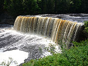 The Tahquamenon Falls State Park is a 46,179 acre (186.9 km²) state park
in the U.S. state of Michigan. It is the second largest of Michigan's state parks. Bordering on Lake Superior
, most of the park is located within Chippewa County
, with the western section of the park extending into Luce County
. The park follows the Tahquamenon River
as it passes over Tahquamenon Falls
and drains into Whitefish Bay
, Lake Superior. The Tahquamenon Falls include a single 50-foot (15 m) drop, the Upper Falls, plus the cascades and rapids collectively called the Lower Falls. During the late-spring runoff, the river drains as much as 50,000 gallons (200,000 liters) of water per second, making the upper falls the second most voluminous vertical waterfall east of the Mississippi River
, after only Niagara Falls
.
. The trunkline turns southwest at the county line. It runs south and west across Murphy Creek and the Auger River before intersecting with H-37 at Four Mile Corner. The highway crosses a branch of the Tahquamenon River one last time before becoming Newberry Avenue in the city of Newberry
. The highest annual average daily traffic
, a measure of traffic volume, was recorded by the Michigan Department of Transportation
(MDOT) for M-123 in 2007 along Newberry Avenue at 7,500 vehicles. South of downtown, M-123 meets M-28 a second time west of Twin Lake. This intersection is the "northern" terminus of the 96.11 miles (154.674 km) highway.
was routed north of Newberry to Four Mile Corner. The first extension of M-123 southward from Eckerman, through Trout Lake to Rogers Park north of St. Ignace, came in 1954. Part of this routing in Trout Lake uses M-48
(now a portion of H-40). An additional extension is shown north to the Tahquamenon River Bridge, lengthening the highway to the north on the April 15, 1954 official state map. The section north to the Tahquamenon River Bridge is remarked on the October 1, 1954 state map as a county road, however. In 1957, M-123 was permanently extended north to the bridge, and in 1962 the final extension north to Paradise and south to Newberry was completed. From Four Mile Corner south, M-123 replaced M-117
to a new terminus at M-28 south of Newberry. The southernmost section of roadway between the I-75/US 2 freeway and H-63 (Old US 2) was transferred to Mackinac County for maintenance with the opening of the freeway in 1963.
On November 9, 2007, MDOT expanded the Tahquamenon Scenic Heritage Route designation previously applied to M-123. This expanded the designation to all of the highway north of M-28, recognizing it for its "outstanding natural beauty" and the scenic views of "rivers, forests, trails and Tahquamenon Falls State Park." Previously, the designation was limited to between Luce County Road 500 to Galloway Creek. The expansion was planned by the Eastern Upper Peninsula Regional Planning & Development Commission along with local governments and businesses.
Michigan Highway System
The Michigan State Trunkline Highway System is made up of all the highways designated as Interstates, U.S. Highways and State Highways in the US state of Michigan. The system is maintained by the Michigan Department of Transportation and comprises of trunklines in all 83 counties of Michigan on...
in the eastern Upper Peninsula
Upper Peninsula of Michigan
The Upper Peninsula of Michigan is the northern of the two major land masses that make up the U.S. state of Michigan. It is commonly referred to as the Upper Peninsula, the U.P., or Upper Michigan. It is also known as the land "above the Bridge" linking the two peninsulas. The peninsula is bounded...
of the U.S. state of Michigan
Michigan
Michigan is a U.S. state located in the Great Lakes Region of the United States of America. The name Michigan is the French form of the Ojibwa word mishigamaa, meaning "large water" or "large lake"....
. It is one of only a few highways in Michigan that curve around and form a U-shape. In fact, M-123 has three intersections with only two state trunklines. It meets M-28
M-28 (Michigan highway)
M-28 is an east–west state trunkline highway that almost completely traverses the Upper Peninsula in the U.S. state of Michigan, from Wakefield to near Sault Ste. Marie in Bruce Township...
twice as a result of its U-shaped routing. M-123 also has a rare signed concurrency
Concurrency (road)
A concurrency, overlap, or coincidence in a road network is an instance of one physical road bearing two or more different highway, motorway, or other route numbers...
with a County-Designated Highway in Michigan; in Trout Lake
Trout Lake Township, Michigan
Trout Lake Township is a civil township of Chippewa County in the U.S. state of Michigan. The population was 465 at the 2000 census.-Geography:...
, there is a concurrency with H-40. All of M-123 north of M-28 is a Scenic Heritage Route within the Michigan Heritage Route
Michigan Heritage Route
Michigan Heritage Route is a designation for roads in Michigan. The designation was created by the state legislature in 1993.The program emphasizes cooperation among local residents, government officials, landowners and interested groups to preserve unique scenic, historic or recreational...
system.
The highway was first designated before 1936 along a section of its current routing. Sections added since then encompass segments formerly belonging to US Highway 2
U.S. Route 2 in Michigan
US Highway 2 is a component of the United States Numbered Highway System that connects Everett, Washington, to the Upper Peninsula of the US state of Michigan, with a separate segment that runs from Rouses Point, New York, to Houlton, Maine...
(US 2) and M-48
M-48 (Michigan highway)
M-48 is an east–west state trunkline highway in the Upper Peninsula of the US state of Michigan. It connects Rudyard with Pickford and continues to the far eastern end of the UP. The highway runs for through rural parts of Chippewa County, including along the county line with Mackinac County...
. The last changes came to the highway in 1962 and 1963, when the northern end was extended and the southern end was truncated slightly.
Route description
M-123 serves a thinly-populated section of the state. Much of the highway passes through the eastern unit of the Hiawatha National ForestHiawatha National Forest
Hiawatha National Forest is a National Forest in the Upper Peninsula of the state of Michigan in the United States. Commercial logging is conducted in some areas. The United States Forest Service administers this National Forest; it is physically divided into two subunits, commonly called the...
. No part of the highway is listed on the National Highway System
National Highway System (United States)
The National Highway System is a network of strategic highways within the United States, including the Interstate Highway System and other roads serving major airports, ports, rail or truck terminals, railway stations, pipeline terminals and other strategic transport facilities.Individual states...
, a system of strategically important highways. The section of highway north of the two M-28
M-28 (Michigan highway)
M-28 is an east–west state trunkline highway that almost completely traverses the Upper Peninsula in the U.S. state of Michigan, from Wakefield to near Sault Ste. Marie in Bruce Township...
junctions is both a Michigan Scenic Heritage Route and part of the Lake Superior Circle Tour.
Rogers Park to Paradise
The southern terminus of the highway is at exit 352 along Interstate 75Interstate 75 in Michigan
Interstate 75 is a part of the Interstate Highway System and runs from Miami, Florida to Sault Ste. Marie in the Upper Peninsula of Michigan. I-75 enters the state from Ohio in the south, just to the north of Toledo. It runs generally north through Detroit, Pontiac and Bay City, crossing the...
(I-75) north of St. Ignace
St. Ignace, Michigan
Saint Ignace, usually written as St. Ignace, is a city in the U.S. state of Michigan. As of the 2000 census, the city population was 2,678. It is the county seat of Mackinac County. From the Lower Peninsula, St. Ignace is the gateway to the Upper Peninsula.St...
in Rogers Park. The roadway also connects to county-designated highway H-63
H-63 (Michigan county highway)
H-63 is a county-designated highway in the Upper Peninsula of Michigan that follows along the Interstate 75 corridor between St. Ignace and Sault Ste. Marie. The road is known as the Mackinac Trail, named for an Indian trail used before European settlers reached the area...
(Old US 2
U.S. Route 2 in Michigan
US Highway 2 is a component of the United States Numbered Highway System that connects Everett, Washington, to the Upper Peninsula of the US state of Michigan, with a separate segment that runs from Rouses Point, New York, to Houlton, Maine...
) at the interchange. From the interchange north, the highway runs northwest as Tahquamenon Trail to the community of Allenville near Brevort Lake in Brevort Township
Brevort Township, Michigan
Brevort Township is a civil township of Mackinac County in the U.S. state of Michigan. As of the 2000 census, the township population was 649. Most of the township land is within the eastern portion of the Hiawatha National Forest...
. Here it meets H-57, a County-Designated Highway. Just north of Allenville, the trunkline crosses through the adjacent commnunity of Moran. Allenville was a stop on the Detroit, Mackinac and Marquette Railroad
Detroit, Mackinac and Marquette Railroad
The Detroit, Mackinac and Marquette Railroad was a land grant railroad that was built and operated briefly in the Upper Peninsula of the U.S. state of Michigan. Incorporated in 1879, the -long railroad began operations in 1881. It was intended to help the economic development of a region of...
, and Moran was named after William B. Moran, one of the early settlement's founders. The roadway runs parallel to a rail line north of Moran. Before crossing into Chippewa County
Chippewa County, Michigan
-National protected areas:* Harbor Island National Wildlife Refuge* Hiawatha National Forest * Whitefish Point Unit of the Seney National Wildlife Refuge-Demographics:...
, the highway passes through the community of Ozark, home of a rock quarry. North of the county line is the community of Trout Lake, where M-123 meets and merges with H-40 across railroad tracks and through town near Wegwaas, Frenchman and Carp lakes. Continuing to the north, the highway is renamed Deerfoot Road and serves the Three Lakes Campground, a unit of the Hiawatha National Forest
Hiawatha National Forest
Hiawatha National Forest is a National Forest in the Upper Peninsula of the state of Michigan in the United States. Commercial logging is conducted in some areas. The United States Forest Service administers this National Forest; it is physically divided into two subunits, commonly called the...
, before meeting M-28
M-28 (Michigan highway)
M-28 is an east–west state trunkline highway that almost completely traverses the Upper Peninsula in the U.S. state of Michigan, from Wakefield to near Sault Ste. Marie in Bruce Township...
at Eckerman.
M-123 is designated as a Scenic Heritage Route north of M-28. Here it continues northwest to East–West Road and turns to run along the shores of Whitefish Bay
Whitefish Bay
Whitefish Bay is a large bay on the eastern end of the southern shore of Lake Superior between Michigan and Ontario. It begins in the north and west at Whitefish Point in Michigan, about 10 miles north of Paradise, Michigan and ends at the St. Marys River at Sault Ste. Marie on the southeast...
and cross the Tahquamenon River near its mouth. Continuing along the bay as Whitefish Road, M-123 meets the community of Paradise
Paradise, Michigan
Paradise is an unincorporated community in Whitefish Township, Chippewa County in the U.S. state of Michigan.Paradise is on the northeastern portion of Michigan's Upper Peninsula, on the western side of Whitefish Bay, Lake Superior, about by road from Sault Ste. Marie and about north of the...
, the northernmost point along the highway. It is here that M-123 intersects Whitefish Point Road, which continues north to Whitefish Point, home of the Great Lakes Shipwreck Museum
Great Lakes Shipwreck Museum
The Great Lakes Shipwreck Museum is located at the Whitefish Point Light Station north of Paradise in Chippewa County in the U.S. state of Michigan. The light station property was transferred to the Great Lakes Shipwreck Historical Society , the Michigan Audubon Society , and the United States...
. In either direction, M-123 runs southbound from Paradise, changing direction. Continuing east of Paradise, M-123 is the only paved road that serves the Tahquamenon Falls State Park and the Whitefish Point region.
Tahquamenon Falls State Park
State park
State parks are parks or other protected areas managed at the federated state level within those nations which use "state" as a political subdivision. State parks are typically established by a state to preserve a location on account of its natural beauty, historic interest, or recreational...
in the U.S. state of Michigan. It is the second largest of Michigan's state parks. Bordering on Lake Superior
Lake Superior
Lake Superior is the largest of the five traditionally-demarcated Great Lakes of North America. It is bounded to the north by the Canadian province of Ontario and the U.S. state of Minnesota, and to the south by the U.S. states of Wisconsin and Michigan. It is the largest freshwater lake in the...
, most of the park is located within Chippewa County
Chippewa County, Michigan
-National protected areas:* Harbor Island National Wildlife Refuge* Hiawatha National Forest * Whitefish Point Unit of the Seney National Wildlife Refuge-Demographics:...
, with the western section of the park extending into Luce County
Luce County, Michigan
-Government:The county government operates the jail, maintains rural roads, operates themajor local courts, keeps files of deeds and mortgages, maintains vital records, administers...
. The park follows the Tahquamenon River
Tahquamenon River
The Tahquamenon River is a long blackwater river in the U.S. state of Michigan that flows in a generally eastward direction through the eastern end of the Upper Peninsula. It drains approximately of the Upper Peninsula, including large sections of Luce County and Chippewa County...
as it passes over Tahquamenon Falls
Tahquamenon Falls
The Tahquamenon Falls are two different waterfalls on the Tahquamenon River. Both sets are located near Lake Superior in the eastern Upper Peninsula of Michigan. The water is notably brown in color from the tannins leached from the cedar swamps which the river drains...
and drains into Whitefish Bay
Whitefish Bay
Whitefish Bay is a large bay on the eastern end of the southern shore of Lake Superior between Michigan and Ontario. It begins in the north and west at Whitefish Point in Michigan, about 10 miles north of Paradise, Michigan and ends at the St. Marys River at Sault Ste. Marie on the southeast...
, Lake Superior. The Tahquamenon Falls include a single 50-foot (15 m) drop, the Upper Falls, plus the cascades and rapids collectively called the Lower Falls. During the late-spring runoff, the river drains as much as 50,000 gallons (200,000 liters) of water per second, making the upper falls the second most voluminous vertical waterfall east of the Mississippi River
Mississippi River
The Mississippi River is the largest river system in North America. Flowing entirely in the United States, this river rises in western Minnesota and meanders slowly southwards for to the Mississippi River Delta at the Gulf of Mexico. With its many tributaries, the Mississippi's watershed drains...
, after only Niagara Falls
Niagara Falls
The Niagara Falls, located on the Niagara River draining Lake Erie into Lake Ontario, is the collective name for the Horseshoe Falls and the adjacent American Falls along with the comparatively small Bridal Veil Falls, which combined form the highest flow rate of any waterfalls in the world and has...
.
Paradise to Newberry
East of Paradise, M-123 runs along the Tahquamenon River inside the state park boundaries. Past the park, the highway is known as Falls Road in Luce CountyLuce County, Michigan
-Government:The county government operates the jail, maintains rural roads, operates themajor local courts, keeps files of deeds and mortgages, maintains vital records, administers...
. The trunkline turns southwest at the county line. It runs south and west across Murphy Creek and the Auger River before intersecting with H-37 at Four Mile Corner. The highway crosses a branch of the Tahquamenon River one last time before becoming Newberry Avenue in the city of Newberry
Newberry, Michigan
Newberry is a village in the U.S. state of Michigan and the county seat of Luce County. Located within McMillan Township at its very southern end, it shares some administrative responsibilities with the surrounding township. The population was 2,686 at the 2000 census.The village was named in...
. The highest annual average daily traffic
Annual average daily traffic
Average Annual daily traffic, abbreviated AADT, is a measure used primarily in transportation planning and transportation engineering. It is the total volume of vehicle traffic of a highway or road for a year divided by 365 days. AADT is a useful and simple measurement of how busy the road is...
, a measure of traffic volume, was recorded by the Michigan Department of Transportation
Michigan Department of Transportation
The Michigan Department of Transportation is a constitutional government agency in the US state of Michigan. The primary purpose of MDOT is to maintain the Michigan State Trunkline Highway System which includes all Interstate, US and state highways in Michigan with the exception of the Mackinac...
(MDOT) for M-123 in 2007 along Newberry Avenue at 7,500 vehicles. South of downtown, M-123 meets M-28 a second time west of Twin Lake. This intersection is the "northern" terminus of the 96.11 miles (154.674 km) highway.
History
The construction of M-123 started in the 1930s near Eckerman, the location of the current eastern M-28/M-123 junction. By 1936, M-123 was designated running north of M-28 on 10 miles (16 km) of hard-surface pavement. At this time, US 2 is routed along Worth Road and uses roadway later used by M-123 from Moran to Rogers Park, and M-48M-48 (Michigan highway)
M-48 is an east–west state trunkline highway in the Upper Peninsula of the US state of Michigan. It connects Rudyard with Pickford and continues to the far eastern end of the UP. The highway runs for through rural parts of Chippewa County, including along the county line with Mackinac County...
was routed north of Newberry to Four Mile Corner. The first extension of M-123 southward from Eckerman, through Trout Lake to Rogers Park north of St. Ignace, came in 1954. Part of this routing in Trout Lake uses M-48
M-48 (Michigan highway)
M-48 is an east–west state trunkline highway in the Upper Peninsula of the US state of Michigan. It connects Rudyard with Pickford and continues to the far eastern end of the UP. The highway runs for through rural parts of Chippewa County, including along the county line with Mackinac County...
(now a portion of H-40). An additional extension is shown north to the Tahquamenon River Bridge, lengthening the highway to the north on the April 15, 1954 official state map. The section north to the Tahquamenon River Bridge is remarked on the October 1, 1954 state map as a county road, however. In 1957, M-123 was permanently extended north to the bridge, and in 1962 the final extension north to Paradise and south to Newberry was completed. From Four Mile Corner south, M-123 replaced M-117
M-117 (Michigan highway)
M-117 is a state trunkline highway in the eastern Upper Peninsula of the US state of Michigan. The highway connects US Highway 2 with M-28 west of Newberry. The designation has been used twice in the UP, once in 1941 for a former section of US 2 between Rexton and Epoufette, and the...
to a new terminus at M-28 south of Newberry. The southernmost section of roadway between the I-75/US 2 freeway and H-63 (Old US 2) was transferred to Mackinac County for maintenance with the opening of the freeway in 1963.
On November 9, 2007, MDOT expanded the Tahquamenon Scenic Heritage Route designation previously applied to M-123. This expanded the designation to all of the highway north of M-28, recognizing it for its "outstanding natural beauty" and the scenic views of "rivers, forests, trails and Tahquamenon Falls State Park." Previously, the designation was limited to between Luce County Road 500 to Galloway Creek. The expansion was planned by the Eastern Upper Peninsula Regional Planning & Development Commission along with local governments and businesses.
Major intersections
External links
- M-123 at Michigan Highways
- M-123 at Michigan Highway Ends
- Tahquamenon State Park, official website