

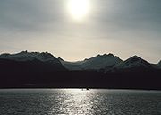
Lynn Canal
Encyclopedia
Inlet
An inlet is a narrow body of water between islands or leading inland from a larger body of water, often leading to an enclosed body of water, such as a sound, bay, lagoon or marsh. In sea coasts an inlet usually refers to the actual connection between a bay and the ocean and is often called an...
(not an artificial canal
Canal
Canals are man-made channels for water. There are two types of canal:#Waterways: navigable transportation canals used for carrying ships and boats shipping goods and conveying people, further subdivided into two kinds:...
) into the mainland of southeast Alaska
Alaska
Alaska is the largest state in the United States by area. It is situated in the northwest extremity of the North American continent, with Canada to the east, the Arctic Ocean to the north, and the Pacific Ocean to the west and south, with Russia further west across the Bering Strait...
.
Lynn Canal runs about 90 miles (144.8 km) from the inlets of the Chilkat River
Chilkat River
The Chilkat River is a river in British Columbia and southeastern Alaska that flows southward from the Coast Range to the Chilkat Inlet and ultimately Lynn Canal. It is about long. It begins at Chilkat Glacier, in Alaska, flows west and south in British Columbia for , enters Alaska and continues...
south to Chatham Strait
Chatham Strait
Chatham Strait, or Shee ya xhaak in the Tlingit language, is a narrow passage of the Alexander Archipelago in the southeastern region of the U.S. state of Alaska. It separates Chichagof Island and Baranof Island to its west from Admiralty Island and Kuiu Island on its east.It is long and extends...
and Stephens Passage
Stephens Passage
Stephens Passage is a channel in the Alexander Archipelago in the southeastern region of the U.S. state of Alaska. It runs between Admiralty Island to the west and the Alaska mainland and Douglas Island to the east, and is about 170 km long...
. At over 2000 feet (609.6 m) in depth, Lynn Canal is the deepest fjord
Fjord
Geologically, a fjord is a long, narrow inlet with steep sides or cliffs, created in a valley carved by glacial activity.-Formation:A fjord is formed when a glacier cuts a U-shaped valley by abrasion of the surrounding bedrock. Glacial melting is accompanied by rebound of Earth's crust as the ice...
in North America
North America
North America is a continent wholly within the Northern Hemisphere and almost wholly within the Western Hemisphere. It is also considered a northern subcontinent of the Americas...
and one of the deepest and longest in the world as well.
The northern portion of the canal braids into the respective Chilkat
Chilkat Inlet
Chilkat Inlet is an inlet in Lynn Canal in the Southeast region of the U.S. state of Alaska that includes the delta for the Chilkat River and borders Haines and the Chilkat Peninsula....
, Chilkoot
Chilkoot Inlet
Chilkoot Inlet is an inlet in the Southeast region of the U.S. state of Alaska, located on the eastern side of the Chilkat Peninsula in Lynn Canal. Chilkoot Inlet is the terminus of the Chilkoot River and its watershed, and also home to Lutak, Alaska....
, and Taiya Inlet
Taiya Inlet
The Taiya Inlet is part of the upper Lynn Canal located in the U.S. state of Alaska. The Taiya Inlet is an estuary which lies in a deep valley, with Skagway, Alaska at its north end and the remainder of the Lynn Canal at its south end.-History:...
s.
Lynn Canal was explored by Joseph Whidbey
Joseph Whidbey
Joseph Whidbey was a member of the Royal Navy who served on the Vancouver Expedition 1791–1795, and later achieved renown as a naval engineer. He is notable for having been the first European to discover and chart Admiralty Island in the Alexander Archipelago in 1794.Little is recorded of...
in 1794 and named by George Vancouver
George Vancouver
Captain George Vancouver RN was an English officer of the British Royal Navy, best known for his 1791-95 expedition, which explored and charted North America's northwestern Pacific Coast regions, including the coasts of contemporary Alaska, British Columbia, Washington and Oregon...
for his birthplace, King's Lynn
King's Lynn
King's Lynn is a sea port and market town in the ceremonial county of Norfolk in the East of England. It is situated north of London and west of Norwich. The population of the town is 42,800....
, Norfolk
Norfolk
Norfolk is a low-lying county in the East of England. It has borders with Lincolnshire to the west, Cambridgeshire to the west and southwest and Suffolk to the south. Its northern and eastern boundaries are the North Sea coast and to the north-west the county is bordered by The Wash. The county...
, England
England
England is a country that is part of the United Kingdom. It shares land borders with Scotland to the north and Wales to the west; the Irish Sea is to the north west, the Celtic Sea to the south west, with the North Sea to the east and the English Channel to the south separating it from continental...
.
Transportation
Lynn Canal's location as a penetrating waterway into the interior connects SkagwaySkagway, Alaska
Skagway is a first-class borough in Alaska, on the Alaska Panhandle. It was formerly a city first incorporated in 1900 that was re-incorporated as a borough on June 25, 2007. As of the 2000 census, the population of the city was 862...
and Haines
Haines, Alaska
Haines is a census-designated place in Haines Borough, Alaska, United States. As of the 2000 census, the population of the area was 1,811. Haines was formerly a city but no longer has a municipal government...
, Alaska to Juneau
Juneau, Alaska
The City and Borough of Juneau is a unified municipality located on the Gastineau Channel in the panhandle of the U.S. state of Alaska. It has been the capital of Alaska since 1906, when the government of the then-District of Alaska was moved from Sitka as dictated by the U.S. Congress in 1900...
and the rest of the Inside Passage
Inside Passage
The Inside Passage is a coastal route for oceangoing vessels along a network of passages which weave through the islands on the Pacific coast of North America. The route extends from southeastern Alaska, in the United States, through western British Columbia, in Canada, to northwestern Washington...
thus making it a major route for shipping, cruise ship
Cruise ship
A cruise ship or cruise liner is a passenger ship used for pleasure voyages, where the voyage itself and the ship's amenities are part of the experience, as well as the different destinations along the way...
s, and ferries
Ferry
A ferry is a form of transportation, usually a boat, but sometimes a ship, used to carry primarily passengers, and sometimes vehicles and cargo as well, across a body of water. Most ferries operate on regular, frequent, return services...
.
During the Klondike Gold Rush
Klondike Gold Rush
The Klondike Gold Rush, also called the Yukon Gold Rush, the Alaska Gold Rush and the Last Great Gold Rush, was an attempt by an estimated 100,000 people to travel to the Klondike region the Yukon in north-western Canada between 1897 and 1899 in the hope of successfully prospecting for gold...
it was a major route to the boom towns of Skagway and Dyea
Dyea, Alaska
Dyea is a former town in the U.S. state of Alaska. A few people live on individual small homesteads in the valley; however, it is largely abandoned. It is located at the convergence of the Taiya River and Taiya Inlet on the south side of the Chilkoot Pass within the limits of the Municipality of...
and thence to the Klondike gold fields. The worst maritime disaster in the history of the Pacific Northwest occurred in Lynn Canal during October 1918, when the S.S. Princess Sophia
Princess Sophia (steamer)
The SS Princess Sophia was a steel-built coastal passenger liner in the coastal service fleet of the Canadian Pacific Railway . Along with the SS Princess Adelaide the SS Princess Alice and the SS Princess Mary, the SS Princess Sophia was one of four sister ships built for CPR during 1910-1911.On...
, steaming southbound from Skagway, grounded on the Vanderbilt Reef
Vanderbilt Reef
Vanderbilt Reef is a rocky outcropping in Lynn Canal, a fjord in Alaska, USA at . The outcropping is visible just above the water's surface....
and later sank, with the loss of all 343 passengers and crew.
After the gold rush and the creation of the White Pass and Yukon Route
White Pass and Yukon Route
The White Pass and Yukon Route is a Canadian and U.S. Class II narrow gauge railroad linking the port of Skagway, Alaska, with Whitehorse, the capital of Yukon. An isolated system, it has no direct connection to any other railroad. Equipment, freight and passengers are ferried by ship through the...
railroad ore and other freight from the Yukon Territory was transported on the railroad to Skagway and its deepwater port and then shipped through Lynn Canal. However, in the 1970s and 1980s the freight subsided as mining activity curtailed in the interior and today very little freight is actually shipped in the Lynn Canal.
Currently, transportation in the canal is provided by Alaska Marine Highway
Alaska Marine Highway
The Alaska Marine Highway or the Alaska Marine Highway System is a ferry service operated by the government of the U.S. state of Alaska. It has its headquarters in Ketchikan, Alaska....
ferries. There are also several other entrepreneurial water taxi
Water taxi
A water taxi or water bus, also known as a commuter boat, is a watercraft used to provide public transport, usually but not always in an urban environment. Service may be scheduled with multiple stops, operating in a similar manner to a bus, or on demand to many locations, operating in a similar...
s and ferries available, but the AMHS is far and away the most frequently used. A project of uncertain future is the Lynn Canal Highway
Lynn Canal Highway
The Lynn Canal Highway, or Juneau Access Road, is a proposed road between Skagway and City and Borough of Juneau, the capital of the U.S. state of Alaska....
.
Because of its high use, the Coast Guard
United States Coast Guard
The United States Coast Guard is a branch of the United States Armed Forces and one of the seven U.S. uniformed services. The Coast Guard is a maritime, military, multi-mission service unique among the military branches for having a maritime law enforcement mission and a federal regulatory agency...
installed several lighthouses in the early 20th century including Eldred Rock Light
Eldred Rock Light
The Eldred Rock Light is an historic octagonal lighthouse adjacent to Lynn Canal in Alaska. It is the last of the ten lighthouses constructed in Alaska between 1902 and 1906...
, Sentinel Island Light
Sentinel Island Light
The Sentinel Island Light is a lighthouse in Alaska adjacent to Lynn Canal in Alaska.-Location:Sentinel Island Light is located at the northern entrance to the Favorite Channel, between the mainland and Lincoln and Shelter Islands...
, and Point Sherman Light
Point Sherman Light
The Point Sherman Light was a lighthouse located north of Juneau, Alaska, along the east side of Lynn Canal, eight miles south of Eldred Rock Light. It is no longer standing.-History:...
.