

Luís Teixeira
Encyclopedia
Portugal
Portugal , officially the Portuguese Republic is a country situated in southwestern Europe on the Iberian Peninsula. Portugal is the westernmost country of Europe, and is bordered by the Atlantic Ocean to the West and South and by Spain to the North and East. The Atlantic archipelagos of the...
Jesuit, cartographer, and mathematician.
He should not be confused with Luís Teixeira Lobo, one of the first Portuguese humanists, son of João Teixeira and brother of Álvaro, who was sent to study in Italy and influenced by the florentine
Florence
Florence is the capital city of the Italian region of Tuscany and of the province of Florence. It is the most populous city in Tuscany, with approximately 370,000 inhabitants, expanding to over 1.5 million in the metropolitan area....
ideals of Angelo Poliziano. Luís Teixeira Lobo was later rector of the University of Siena (1476), Professor of Law at Ferrara (1502) and teacher to the King John III of Portugal
John III of Portugal
John III , nicknamed o Piedoso , was the fifteenth King of Portugal and the Algarves. He was the son of King Manuel I and Maria of Aragon, the third daughter of King Ferdinand II of Aragon and Queen Isabella I of Castile...
.
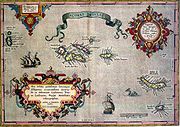
Teixeira contributed a well-known early map of Japan (Iaponiae Insulae Descriptio) http://www.themaphouse.com/SpecialistCatalogues/MythicalIslands.aspx http://www.cartography.henny-savenije.pe.kr/vanlinschoten.htm to Abraham Ortelius
Abraham Ortelius
thumb|250px|Abraham Ortelius by [[Peter Paul Rubens]]Abraham Ortelius thumb|250px|Abraham Ortelius by [[Peter Paul Rubens]]Abraham Ortelius (Abraham Ortels) thumb|250px|Abraham Ortelius by [[Peter Paul Rubens]]Abraham Ortelius (Abraham Ortels) (April 14, 1527 – June 28,exile in England to take...
's atlas Theatrum Orbis Terrarum
Theatrum Orbis Terrarum
Theatrum Orbis Terrarum is considered to be the first true modern atlas. Written by Abraham Ortelius and originally printed on May 20, 1570, in Antwerp, it consisted of a collection of uniform map sheets and sustaining text bound to form a book for which copper printing plates were specifically...
. It was the first separate map of Japan, and was for many years the standard map of Japan used by Europeans (until the 1655 map by Martino Martini
Martino Martini
Martino Martini was an Italian Jesuit missionary, cartographer and historian, mainly working on ancient Imperial China.-Early years:Martini was born in Trento, in the Bishopric of Trent...
).
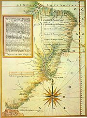
An important atlas of Brazil
Brazil
Brazil , officially the Federative Republic of Brazil , is the largest country in South America. It is the world's fifth largest country, both by geographical area and by population with over 192 million people...
is attributed to Teixeira, entitled Roteiro de todos os sinais, conhecimentos, fundos, baixos, alturas, e derrotas que há na costa do Brasil desde o Cabo de Santo Agostinho até ao estreito de Fernão de Magalhães (1586).