

Low Beskids
Encyclopedia
Beskids
The Beskids , ) is a traditional name for a series of Eastern European mountain ranges.- Definition :The Beskids are approximately 600 km in length and 50–70 km in width...
mountain range
Mountain range
A mountain range is a single, large mass consisting of a succession of mountains or narrowly spaced mountain ridges, with or without peaks, closely related in position, direction, formation, and age; a component part of a mountain system or of a mountain chain...
s in the Outer
Outer Carpathians
Outer Carpathians is a part of Carpathian Mountains, comprising Outer Western Carpathians and Outer Eastern Carpathians, including the corresponding Outer Carpathian Depressions. Boundary between Outer Western Carpathians and Central Western Carpathians is complicated zone called Pieniny Klippen...
Eastern Carpathians in southeastern Poland
Poland
Poland , officially the Republic of Poland , is a country in Central Europe bordered by Germany to the west; the Czech Republic and Slovakia to the south; Ukraine, Belarus and Lithuania to the east; and the Baltic Sea and Kaliningrad Oblast, a Russian exclave, to the north...
and northeastern Slovakia
Slovakia
The Slovak Republic is a landlocked state in Central Europe. It has a population of over five million and an area of about . Slovakia is bordered by the Czech Republic and Austria to the west, Poland to the north, Ukraine to the east and Hungary to the south...
. Is a hilly region in Prešov Region
Prešov Region
The Prešov Region is one of the eight Slovak administrative regions. It consists of 13 districts.-Geography:It is located in north-eastern Slovakia and has an area of 8,975 km². The region has diverse types of landscapes occurring in Slovakia, but mostly highlands and hilly lands dominate the...
, Sanok County
Sanok County
Sanok County is a unit of territorial administration and local government in Subcarpathian Voivodeship, south-eastern Poland, on the Slovak border. It came into being on January 1, 1999, as a result of the Polish local government reforms passed in 1998. Its administrative seat and largest town is...
and Jasło County, between Busov, Ondavská vrchovina, Laborecká vrchovina, Beskydské predhorie in Slovakia, Beskid Sądecki, Pogórze Bukowskie
Pogórze Bukowskie
The Pogórze Bukowskie is one of the Beskids mountain ranges of the Outer Eastern Carpathians in southeastern Poland, part of the Central Beskidian Piedmont...
and Bieszczady near the river Wisłoka, Wisłok and Osława in Poland.
The mountain has two separate summits, one of 1,002 (Busov) and one of 997 meters (Lackowa).
The Low Beskids separating the East
Bieszczady Mountains
Bieszczady is the Polish name for a mountain range in the extreme south-east of Poland, extending into Ukraine and Slovakia...
from the West Carpathians.
Original flora and fauna was preserved because of the area's remoteness. The mountain range is covered with beech
Beech
Beech is a genus of ten species of deciduous trees in the family Fagaceae, native to temperate Europe, Asia and North America.-Habit:...
forests. The area is protected by Magurski National Park
Magurski National Park
Magura National Park is a National Park located in the south-east of Poland, close to Slovakia, on the boundary of Lesser Poland Voivodeship and Subcarpathian Voivodeship. It covers the main part of the upper basin of the Wisłoka river...
and Jaśliski Park Krajobrazowy.
Animals living in this reserve are, amongst others, black stork
Black Stork
The Black Stork Ciconia nigra is a large wading bird in the stork family Ciconiidae. It is a widespread, but rare, species that breeds in the warmer parts of Europe, predominantly in central and eastern regions. This is a shy and wary species, unlike the closely related White Stork. It is seen in...
s, deers
Roe Deer
The European Roe Deer , also known as the Western Roe Deer, chevreuil or just Roe Deer, is a Eurasian species of deer. It is relatively small, reddish and grey-brown, and well-adapted to cold environments. Roe Deer are widespread in Western Europe, from the Mediterranean to Scandinavia, and from...
and wolves.
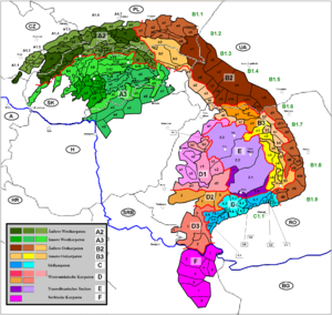
Division
Since there exist many variants of divisions of the mountain ranges and names for the Beskids, several divisions are given in the following:- Busov (Slovakia),
- Ondavská vrchovina (Slovakia),
- Laborecká vrchovina Slovakia),
- Beskydské predhorie (Slovakia),
- Góry Grybowskie - near rivers Kamienica and Biała (Poland),
- Góry Hańczowskie - near rivers Biała, Ropa and Zdynia, (Poland),
- Beskid Gorlicki - near river Biała, villages : Radocyna, BartneBartneBartne is a village in the administrative district of Gmina Sękowa, within Gorlice County, Lesser Poland Voivodeship, in southern Poland, close to the border with Slovakia. It lies approximately east of Sękowa, south-east of Gorlice, and south-east of the regional capital Kraków.The village has...
, Wołowiec, - Pasmo Magurskie - mountains ranges Magura Wątkowska and Małastowskie,
- Beskid Dukielski - between rivers Wisłoka and Tabor, (Poland),
- Gniazdo Jawornika - between rivers Jasiołki i Wisłoka, (Poland),
- Pasmo BukowicyBukowica RangeBukowica Range part of the Pogórze Bukowskie and Low Beskids in southern Poland. The Bukowica created by the long mountain massif, situated in the eastern part of the Beskid Niski between the valleys of the Wisłok and Osławica rivers...
and Kamieni Peak - between rivers Wisłok and Osławica, - Pasmo graniczne - near river Bełcza, (Poland),
- Wzgórza Rymanowskie - near river Tabor,(Poland),
See also: Divisions of the Carpathians
Divisions of the Carpathians
Divisions of the Carpathians is categorization of the Carpathian mountains system.Below is a detailed overview of the major subdivisions and ranges of the Carpathian Mountains. The Carpathians are a "subsystem" of a bigger Alps-Himalaya System that stretches from the western Europe all the way to...
.
Beskid Niski in Poland
The region then became a site of contention between PolandPoland
Poland , officially the Republic of Poland , is a country in Central Europe bordered by Germany to the west; the Czech Republic and Slovakia to the south; Ukraine, Belarus and Lithuania to the east; and the Baltic Sea and Kaliningrad Oblast, a Russian exclave, to the north...
, Kievan Rus and Hungary
Hungary
Hungary , officially the Republic of Hungary , is a landlocked country in Central Europe. It is situated in the Carpathian Basin and is bordered by Slovakia to the north, Ukraine and Romania to the east, Serbia and Croatia to the south, Slovenia to the southwest and Austria to the west. The...
starting in at least the 9th century.
Up until 1947, 45% of the population of the part of the mountains was Lemkos
Lemkos
Lemkos , one of several quantitatively and territorially small ethnic groups who also call themselves Rusyns , are one of the ethnic groups inhabiting the Carpathian Mountains...
and Dolinians, 45% Polish Uplanders
Pogórzanie
Pogórzanie , also known as Western Pogorzans and Eastern Pogorzans, are a distinctive subethnic group of Poles that mostly live in the Central Beskidian Range of the Podkarpacie highlands....
and 10% Jews
Jews
The Jews , also known as the Jewish people, are a nation and ethnoreligious group originating in the Israelites or Hebrews of the Ancient Near East. The Jewish ethnicity, nationality, and religion are strongly interrelated, as Judaism is the traditional faith of the Jewish nation...
. The killing of the Polish General Karol Świerczewski
Karol Swierczewski
Karol Wacław Świerczewski was a Pole who became a Soviet military officer and a general. He served as a general in the service of the Soviet Union, Republican Spain, and the Soviet sponsored Polish Provisional Government of National Unity after World War II.- Life :Karol Świerczewski grew up in...
in Jabłonki by the Ukrainian Insurgent Army in 1947 was the direct cause of the replacement of the Lemkos, the so-called Operation Vistula.
Nízke Beskydy in Slovakia
The territory of present-day Nízke Beskydy has attracted settlers since the Stone AgeStone Age
The Stone Age is a broad prehistoric period, lasting about 2.5 million years , during which humans and their predecessor species in the genus Homo, as well as the earlier partly contemporary genera Australopithecus and Paranthropus, widely used exclusively stone as their hard material in the...
. The Slavic forefathers of the Slovaks gradually moved to the basin of Humenné
Humenné
Humenné is a town in the Prešov Region in eastern Slovakia and the second largest town of the historic Zemplín region. It lies at the volcanic Vihorlat mountains and at the confluence of the Laborec and Cirocha Rivers.-Characteristics:...
and Bardejov
Bardejov
Bardejov is a town in North-Eastern Slovakia. It is situated in the Šariš region and has about 33,000 inhabitants. The spa town, mentioned for the first time in 1241, exhibits numerous cultural monuments in its completely intact medieval town center...
during the great migration of peoples, starting in the 5th century. An intensive and organized settlement of this area started as late as in the middle of the 13th century, after the Mongol raids. However, the first written reference to the town dates back to the 1240s, when monks from Bardejov complained to the King Béla IV
Béla IV of Hungary
Béla IV , King of Hungary and of Croatia , duke of Styria 1254–58. One of the most famous kings of Hungary, he distinguished himself through his policy of strengthening of the royal power following the example of his grandfather Bela III, and by the rebuilding Hungary after the catastrophe of the...
about a violation of the town’s borders by Prešov
Prešov
Prešov Historically, the city has been known in German as Eperies , Eperjes in Hungarian, Fragopolis in Latin, Preszów in Polish, Peryeshis in Romany, Пряшев in Russian and Пряшів in Rusyn and Ukrainian.-Characteristics:The city is a showcase of Baroque, Rococo and Gothic...
.
Rural landscape pictures
 |
 |
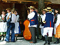 |
Towns and villages
Important towns and villages of this region include:- BardejovBardejovBardejov is a town in North-Eastern Slovakia. It is situated in the Šariš region and has about 33,000 inhabitants. The spa town, mentioned for the first time in 1241, exhibits numerous cultural monuments in its completely intact medieval town center...
- HumennéHumennéHumenné is a town in the Prešov Region in eastern Slovakia and the second largest town of the historic Zemplín region. It lies at the volcanic Vihorlat mountains and at the confluence of the Laborec and Cirocha Rivers.-Characteristics:...
- SvidníkSvidníkSvidník is a town in eastern Slovakia, acting as the capital of Svidník District in Prešov Region. It has a population of 12,384 .-Geography:...
- MedzilaborceMedzilaborceMedzilaborce is a town in northeastern Slovakia close to the border with Poland, located near the towns of Sanok and Bukowsko . Its population is approximately 6,600.-Characteristics:...
- StropkovStropkovStropkov is a town in Stropkov District, Prešov Region, Slovakia.-History:Stropkov is an economical, social and cultural centre of north Zemplín...
- GiraltovceGiraltovceGiraltovce is a town lying the in Prešov Region, eastern Slovakia.-Twin towns — Sister cities:Giraltovce is twinned with:-External links:*...
- BukowskoBukowskoBukowsko is a village in Sanok County, Subcarpathian Voivodeship, Poland. It's in the Bukowsko Upland mountains, parish in loco, located near the towns of Medzilaborce and Palota . During the Polish–Lithuanian Commonwealth it was in Lesser Poland prowincja.-Characteristics:Bukowsko is the...
- GrybówGrybówGrybów is a town in the Nowy Sącz County, in Lesser Poland Voivodeship of Poland, with 12,409 inhabitants . It is located in the heartland of the Doły , and its average altitude is 370 metres above sea level, although there are some hills located within the confines of the city, Grybów has the...
- GorliceGorliceGorlice is a city and an urban municipality in south eastern Poland with around 29,500 inhabitants . It is situated south east of Kraków and south of Tarnów between Jasło and Nowy Sącz in the Lesser Poland Voivodeship , previously in Nowy Sącz Voivodeship...
- Iwonicz ZdrójIwonicz ZdrójIwonicz-Zdrój . It is located in the heartland of the Doły , and its average altitude is 410 metres above sea level, although there are some hills located within the confines of the city....
- Rymanów-Zdrój
Ethnic groups
- Carpathian GermansCarpathian GermansCarpathian Germans , sometimes simply called Slovak Germans , are a group of German language speakers on the territory of present-day Slovakia...
- SlovaksSlovaksThe Slovaks, Slovak people, or Slovakians are a West Slavic people that primarily inhabit Slovakia and speak the Slovak language, which is closely related to the Czech language.Most Slovaks today live within the borders of the independent Slovakia...
- PolesPolesthumb|right|180px|The state flag of [[Poland]] as used by Polish government and diplomatic authoritiesThe Polish people, or Poles , are a nation indigenous to Poland. They are united by the Polish language, which belongs to the historical Lechitic subgroup of West Slavic languages of Central Europe...
- Polish Uplanders
- RusynsRusynsCarpatho-Rusyns are a primarily diasporic ethnic group who speak an Eastern Slavic language, or Ukrainian dialect, known as Rusyn. Carpatho-Rusyns descend from a minority of Ruthenians who did not adopt the use of the ethnonym "Ukrainian" in the early twentieth century...
- LemkosLemkosLemkos , one of several quantitatively and territorially small ethnic groups who also call themselves Rusyns , are one of the ethnic groups inhabiting the Carpathian Mountains...
- Lemkos
Hiking trails
- European walking route E8European walking route E8The E8 European long distance path or E8 path is one of the European long-distance paths, leading 4700km across Europe, from Cork in Ireland to Istanbul in Turkey....

-
- Somár - sedlo Baba - Dolná Rakova - Končini - Brezová pod BradlomBrezová pod BradlomBrezová pod Bradlom is a town in the Myjava District, Trenčín Region, western Slovakia, at the western foothills of the Little Carpathians, in the Záhorie region.-History:...
- PoliankaPoliankaPolianka is a village and municipality in Myjava District in the Trenčín Region of north-western Slovakia.-Geography:The municipality lies at an altitude of 410 metres and covers an area of 9.419 km². It has a population of about 356 people....
- MyjavaMyjavaMyjava is a town in Trenčín Region, Slovakia.-Geography:It is located in the Myjava Hills at the foothills of the White Carpathians and not far from the Little Carpathians. The river Myjava flows through the town...
- Veľká Javorina - Nové Mesto nad VáhomNové Mesto nad VáhomNové Mesto nad Váhom is a town in the Trenčín Region of Slovakia.- Geography :District town located at the northern edge of the Danubian Hills at the foothills of the northern end of the White Carpathians, on the Váh river. Other mountains nearby are the White Carpathians and the Považský Inovec...
- Machnáč - TrenčínTrencínTrenčín is a city in western Slovakia of the central Váh River valley near the Czech border, around from Bratislava. It has a population of more than 56,000, which makes it the ninth largest municipality of the country and is the seat of the Trenčín Region and the Trenčín District...
- Košecké Rovné - Fačkovské sedlo - KunešovKunešovKunešov is a village and municipality in Žiar nad Hronom District in the Banská Bystrica Region of central Slovakia. The village has a German minority ....
- Kraľová studňa - DonovalyDonovalyDonovaly is a village in the Banská Bystrica Region of central Slovakia. Being situated in an important pass between the mountains of Veľká Fatra and Starohorské vrchy, on the route connecting Banská Bystrica with Ružomberok, it became a prominent centre of winter and summer...
- ChopokChopokChopok is the second highest peak of the Low Tatra range or third , in central Slovakia. The peak offers a panoramatic view of High Tatra, Liptov and the valley of Hron...
- ČertovicaCertovicaČertovica is a mountain pass in the Low Tatras mountain range in Slovakia. It connects regions of Liptov and Horehronie. With AMSL, it is the highest paved mountain pass in Slovakia. It is open all year round, however it can be rarely closed during the winter because of the severe weather...
- TelgártTelgártTelgárt is a village and municipality in Brezno District, in the Banská Bystrica Region of central Slovakia.-History:In historical records the village was first mentioned in 1326 or in 1549 .-Geography:...
- SkaliskoSkaliskoSkalisko is a settlement in the administrative district of Gmina Budry, within Węgorzewo County, Warmian-Masurian Voivodeship, in northern Poland, close to the border with the Kaliningrad Oblast of Russia....
- Štós-kúpele - SkaliskoSkaliskoSkalisko is a settlement in the administrative district of Gmina Budry, within Węgorzewo County, Warmian-Masurian Voivodeship, in northern Poland, close to the border with the Kaliningrad Oblast of Russia....
- Chata Lajoška - KošiceKošiceKošice is a city in eastern Slovakia. It is situated on the river Hornád at the eastern reaches of the Slovak Ore Mountains, near the border with Hungary...
- Malý ŠarišMalý ŠarišMalý Šariš is a village and municipality in Prešov District in the Prešov Region of eastern Slovakia.-Geography:The municipality lies at an elevation of 300 metres and covers an area of 8.635 km² . It has a population of about 1365 people.-External...
- PrešovPrešovPrešov Historically, the city has been known in German as Eperies , Eperjes in Hungarian, Fragopolis in Latin, Preszów in Polish, Peryeshis in Romany, Пряшев in Russian and Пряшів in Rusyn and Ukrainian.-Characteristics:The city is a showcase of Baroque, Rococo and Gothic...
- Miháľov - KurimkaKurimkaKurimka is a village and municipality in Svidník District in the Prešov Region of north-eastern Slovakia.-Geography:The municipality lies at an altitude of 329 metres and covers an area of 12.460 km²...
- DuklaDuklaDukla ; , Duklya] is a town and an eponymous municipality in southeastern Poland, in the Subcarpathian Voivodship. The town is populated by 2,127 people . while the total population of the commune containing the town and the villages surrounding it is 16,640...
- Iwonicz-Zdrój – Rymanów-Zdrój - Puławy – TokarniaTokarnia (peak)Takarnia is a peak in the Bukowica Range in southern Poland. Its height is 778 meters.The southern part is a steep rocky wall, while the other side consist of less steep rocky fields...
(778 m) – Kamień (717 m) – KomańczaKomanczaKomańcza is a village in the Sanok County, in the Subcarpathian Voivodeship of south-eastern Poland. It is situated in the Bukowsko Upland mountains, located near the towns of Medzilaborce and Palota .-History:...
- CisnaCisnaCisna is the main village of the Gmina Cisna in the Lesko County, in the Subcarpathian Voivodeship of south-eastern Poland. It lies in the Solinka valley in between the Bieszczady mountains.-History:...
- Ustrzyki GórneUstrzyki GórneUstrzyki Górne is a village in the administrative district of Gmina Lutowiska, within Bieszczady County, Subcarpathian Voivodeship, in south-eastern Poland, close to the border with Ukraine. It lies approximately south of Lutowiska, south of Ustrzyki Dolne, and south-east of the regional...
-TarnicaTarnicaTarnica is a peak in the Bieszczady Mountains in southern Poland. Its height is 1,346 meters. It is one of the Polish Crown Peaks.The summit towers 500 meter above the Wołosatka Valley. It can be easily told apart from its neighbours by its distinctive shape. The mountain has two separate...
- Wołosate.
- Somár - sedlo Baba - Dolná Rakova - Končini - Brezová pod Bradlom
Literature
- Prof. Jerzy Kondracki. Geografia fizyczna Polski Warszawa : Państ. Wydaw. Naukowe , 1988, ISBN 83-01-02323-6.
- Prof. Jadwiga Warszyńska. Karpaty Polskie : przyroda, człowiek i jego działalność ; Uniwersytet Jagielloński. Kraków , 1995 ISBN 83-233-0852-7.