

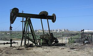
Lost Hills Oil Field
Encyclopedia

Oil field
An oil field is a region with an abundance of oil wells extracting petroleum from below ground. Because the oil reservoirs typically extend over a large area, possibly several hundred kilometres across, full exploitation entails multiple wells scattered across the area...
in the Lost Hills
Lost Hills
The Lost Hills are a low mountain range in the Transverse Ranges, near Lost Hills, California and Interstate 5 in western Kern County, California....
Range, north of the town of Lost Hills
Lost Hills, California
Lost Hills is a census-designated place in Kern County, California, United States. Lost Hills is located west-northwest of Bakersfield, at an elevation of 305 feet...
in western Kern County
Kern County, California
Spreading across the southern end of the California Central Valley, Kern County is the fifth-largest county by population in California. Its economy is heavily linked to agriculture and to petroleum extraction, and there is a strong aviation and space presence. Politically, it has generally...
, California
California
California is a state located on the West Coast of the United States. It is by far the most populous U.S. state, and the third-largest by land area...
, in the United States
United States
The United States of America is a federal constitutional republic comprising fifty states and a federal district...
.
Production
While only the 18th-largest oil field in California in size, in total remaining reserves it ranks sixth, with the equivalent of over 110 Moilbbl producible reserves still in the ground, according to the California Division of Oil, Gas and Geothermal Resources (Chevron Corp., the principal operator, estimates considerably more oil in the ground). Production at Lost Hills has been increasing steadily: as of the end of 2006, it was California's second-fastest growing oil field, exceeded only by the nearby Cymric FieldCymric Oil Field
The Cymric Oil Field is a large oil field in Kern County, California in the United States. While only the 14th-largest oil field in California in total size, in terms of total remaining reserves it ranks fifth, with the equivalent of over still in the ground...
.
The Lost Hills field also contains considerable reserves of natural gas
Natural gas
Natural gas is a naturally occurring gas mixture consisting primarily of methane, typically with 0–20% higher hydrocarbons . It is found associated with other hydrocarbon fuel, in coal beds, as methane clathrates, and is an important fuel source and a major feedstock for fertilizers.Most natural...
. In 1998, one of the field's gas wells was the site of a spectacular blowout, producing a pillar of fire which burned for 14 days and was visible more than 40 miles (64.4 km) away.
Setting

San Joaquin Valley
The San Joaquin Valley is the area of the Central Valley of California that lies south of the Sacramento – San Joaquin River Delta in Stockton...
. The hills rise scarcely more than 200 feet (61 m) above the San Joaquin Valley to the east, and only 100 feet (30.5 m) or less above the Antelope Plain to the west; in places they are almost flat. The hills and associated oil field are between Interstate 5 to the east and State Route 33
California State Route 33
State Route 33 is a north–south state highway in the U.S. state of California. SR 33 replaced part of U.S. Route 399 in 1964 during the "great renumbering" of routes. In the unincorporated sections of Kern County it is known as the West Side Highway...
to the west, both of which parallel the field; Interstate 5 runs about four miles (6 km) away and Route 33 about seven. The California Aqueduct
California Aqueduct
The Governor Edmund G. Brown California Aqueduct is a system of canals, tunnels, and pipelines that conveys water collected from the Sierra Nevada Mountains and valleys of Northern- and Central California to Southern California. The Department of Water Resources operates and maintains the...
runs adjacent to the field boundary on the northeast, and the town of Lost Hills
Lost Hills, California
Lost Hills is a census-designated place in Kern County, California, United States. Lost Hills is located west-northwest of Bakersfield, at an elevation of 305 feet...
is on the other side of the aqueduct along California State Route 46
California State Route 46
State Route 46 is an east–west state highway in the U.S. state of California. It is a major crossing of the Coast Ranges, connecting SR 1 on the Central Coast near Cambria and US 101 in Paso Robles with SR 99 at Famoso in the San Joaquin Valley. East of Paso Robles, where it carried U.S...
, which passes through the field from east to west.
The climate in the Lost Hills area is arid to semi-arid, with an average rainfall of five to six inches (152 mm) a year, almost all in the winter months. Vegetation in the vicinity of the field is mostly grassland and sparse scrub, with some adjacent orchards, although in the oil field itself most vegetation has been removed from the areas of active operations.
Geology
Anticline
In structural geology, an anticline is a fold that is convex up and has its oldest beds at its core. The term is not to be confused with antiform, which is a purely descriptive term for any fold that is convex up. Therefore if age relationships In structural geology, an anticline is a fold that is...
s between the Coalinga Oil Field
Coalinga Oil Field
The Coalinga Oil Field is a large oil field in western Fresno County, California, in the United States. It surrounds the town of Coalinga, about half-way between Los Angeles and San Francisco, to the west of Interstate 5, at the foot of the Diablo Range...
on the north and the Midway-Sunset Field
Midway-Sunset Oil Field
The Midway-Sunset Oil Field is a large oil field in Kern County, San Joaquin Valley, California in the United States. Discovered in 1894, and having a cumulative production of close to of oil at the end of 2006, it is the largest oil field in California and the third largest in the United States....
on the south, along the western edge of the San Joaquin Valley. These anticlines run closely parallel to the San Andreas Fault
San Andreas Fault
The San Andreas Fault is a continental strike-slip fault that runs a length of roughly through California in the United States. The fault's motion is right-lateral strike-slip...
to the west, and formed as a result of compression from tectonic movement. The Lost Hills Field occupies a portion of a SE-plunging anticline. There are six oil pools in the five producing units, which are, from the top, the Tulare Formation, of Pleistocene
Pleistocene
The Pleistocene is the epoch from 2,588,000 to 11,700 years BP that spans the world's recent period of repeated glaciations. The name pleistocene is derived from the Greek and ....
age; the Etchegoin Formation, of Pliocene
Pliocene
The Pliocene Epoch is the period in the geologic timescale that extends from 5.332 million to 2.588 million years before present. It is the second and youngest epoch of the Neogene Period in the Cenozoic Era. The Pliocene follows the Miocene Epoch and is followed by the Pleistocene Epoch...
age; the Reef Ridge Shale, McClure Shale, and Devilwater Shale, members of the Monterey Formation
Monterey Formation
The Monterey Formation is an extensive Miocene oil-rich geological sedimentary formation in California, with massive outcroppings of the formation in areas of the California Coast Ranges, Peninsular Ranges, and on some of California's off-shore islands...
, of Miocene age, which can be found in much of coastal California; and the Temblor formation, underneath the others, of Oligocene
Oligocene
The Oligocene is a geologic epoch of the Paleogene Period and extends from about 34 million to 23 million years before the present . As with other older geologic periods, the rock beds that define the period are well identified but the exact dates of the start and end of the period are slightly...
and Miocene age. A well drilled to 11553 feet (3,521.4 m) by Mobil Oil Corp.
Mobil
Mobil, previously known as the Socony-Vacuum Oil Company, was a major American oil company which merged with Exxon in 1999 to form ExxonMobil. Today Mobil continues as a major brand name within the combined company, as well as still being a gas station sometimes paired with their own store or On...
in the Williamson Lease identified further rock units as old as the Upper Cretaceous below the Temblor, but none of these lowest units have had oil pools.
The Belridge Diatomite portion of the Monterey Formation defines the productive limits of the field. Characteristic of this rock unit is that it is full of oil – almost 50% of the unit is saturated, and the unit has high porosity, in the 45% to 70% range – but very little of the oil has been recoverable from the unit (only three to four percent so far). According to Chevron's estimate, there are approximately 2.2 Goilbbl of oil in place in the Lost Hills Field, only five percent of which has been extracted. The oil in place is about twenty times greater than the California Department of Oil and Gas reserves estimate (109 Moilbbl), which is volume that can be economically produced.
Well spacing on Lost Hills varies based on the geologic characteristics in the unit being drilled, with one well per 5 acres (20,234.3 m²) in siliceous shale to one well per 1.25 acres (5,058.6 m²) in diatomite.
A peculiarity of the Lost Hills operations is the pronounced subsidence of the ground surface as it collapses into the area vacated by the petroleum after being pumped out. Portions of the hills overlying the oil field have subsided up to eight feet in the central region of operations, and subsidence occurs field-wide at a rate of about nine inches per year. The dropping land surface causes operational problems, including fractures of well casings, and sometimes complete well failures. Waterflooding – the practice of filling the reservoir with water to push petroleum to recovery wells, and thereby also reoccupying the space vacated by oil and gas – has partially mitigated the problem. Some wells have actually disappeared into craters: in 1976, a Getty Oil well blew out, and quickly collapsed into a crater over 15 feet (4.6 m) deep and 30 across, taking with it the concrete pad, casing, and pumping unit. Yet another Getty well suffered the same fate in 1978.
History and operations
Drillers Martin and Dudley discovered the Lost Hills Oil Field in July 1910 – accidentally. They were drilling a water well for livestock grazing; instead of finding groundwater, however, they struck oil, specifically the Etchegoin Pool at a depth of 530 feet (161.5 m). Other drillers, encouraged by the find, including the mighty Standard OilStandard Oil
Standard Oil was a predominant American integrated oil producing, transporting, refining, and marketing company. Established in 1870 as a corporation in Ohio, it was the largest oil refiner in the world and operated as a major company trust and was one of the world's first and largest multinational...
of California, which had recently been subject to antitrust litigation and broken up
Standard Oil Co. of New Jersey v. United States
Standard Oil Co. of New Jersey v. United States, 221 U.S. 1 , was a case in which the Supreme Court of the United States found Standard Oil guilty of monopolizing the petroleum industry through a series of abusive and anticompetitive actions...
by the Supreme Court
Supreme Court of the United States
The Supreme Court of the United States is the highest court in the United States. It has ultimate appellate jurisdiction over all state and federal courts, and original jurisdiction over a small range of cases...
, began drilling for more nearby; they soon found the Cahn and Reef Ridge pools, in 1913, and then the Tulare pool in 1915. There were relatively few wells on the field for the first several decades; indeed, by 1979, there were only 39 wells producing from the Monterey Formation, and each of these wells only produced an average of eight barrels per day. It took the development of advanced recovery technology to turn the Lost Hills into a high-producing oil field.
Unusually for a California oil field, the years of maximum recovery were not early in the 20th century, but recently: peak oil production from the Etchegoin Pool did not occur until the early 21st century, assisted by several enhanced recovery technologies, including water flooding and cyclic steam flooding. The early peak in production took place in 1917, during which 4 Moilbbl of oil were pumped; then production steadily declined, with a few spikes, until the enhanced recovery techniques which began to be employed in the 1960s began to pay off. In 1981 the field produced almost 6 Moilbbl, and has remained a high producer, reaching close to 12 Moilbbl in 2006. During that year it had the fourth-largest production increase in the state, and preliminary estimates for 2007 show that production has increased yet again, to 12.2 Moilbbl
As of 1997, four pools – the Tulare, Etchegoin, Cahn, and Reef Ridge – continued to have active recovery operations using waterflooding, steam flooding, and fire flooding. As of 2008, the principal operators on the Lost Hills Field were Chevron Corp. and Aera Energy LLC
Aera Energy LLC
Aera Energy LLC is a natural gas, oil exploration and production company jointly owned by Shell and ExxonMobil headquartered in Bakersfield, California...
.
Bellevue blowout
In 1998, the Lost Hills Field was the site of one of the largest and most spectacular well blowouts in modern U.S. history. The Bellevue blowout – also called the "Bellevue gusher" – involved six months of uncontrolled natural gas expulsion, and a gigantic gas fire that lasted two weeks.On the evening of November 23, a wildcat well being drilled into a promising anticlinal fold underneath the Monterey Formation, northeast of the main Lost Hills field, reached the depth of 17000 feet (5,181.6 m) and hit a previously untapped reservoir of gas under intense pressure. Natural gas and petroleum condensate burst from the well, immediately exploding into flame, knocking over the massive drilling rig, destroying the trailer, and melting the nearby drilling equipment. This enormous pillar of fire, which rose more than 300 feet (91.4 m) into the sky, could be seen more than 40 miles (64.4 km) away, and the quantity of gas bursting from the well has been estimated at between 40 to 100 Mcuft per day. It burned for fourteen days, and continued spewing even after the fire was out; only a secondary well bore, drilled at a slant to intercept the main well, was able to plug the opening and snuff the blowout at last.