
Los Altos, Central America
Encyclopedia
Los Altos was an area of Central America
, which was added as a sixth state to the Federal Republic of Central America
in the 1830s. Its capital was Quetzaltenango
. Los Altos occupied eight departments in the west of present-day Guatemala
as well as the Soconusco
region in the Mexican
state of Chiapas
.
The state originated from the political differences and tensions between Guatemala City
on one side, and Quetzaltenango
and other parts of western Central America on the other. Debate about separation from Guatemala dated from shortly after Central America
n independence from Spain
in 1821. Such a separate state was provided for by the Federal constitutional assembly of November 1824, but there was sizable opposition to the separation in Guatemala City
.
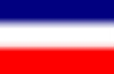
The independence of Los Altos from Guatemala was officially proclaimed on 2 February 1838. The Federal government recognized Los Altos as the sixth state of the union and seated the representatives of Los Altos in the Federal Congress on 5 June of that year. The flag
of Los Altos was a modification of that of the Central American Union, with a central seal showing a volcano
in the background with a quetzal
(a local bird symbolizing liberty
) in front. This was the first Central American flag to use the quetzal
as a symbol; since 1871, it has been on the present flag of Guatemala
.
Los Altos consisted of the administrative regions of Totonicapán (the modern Guatemalan departments of Totonicapán
, Huehuetenango
), Quetzaltenango (the modern departments of Quetzaltenango and San Marcos
) and Suchitepéquez-Sololá (the modern departments of Retalhuleu
, Suchitepéquez
, Sololá
, and Quiché
).
As the Federation crumbled into civil war
, Los Altos declared itself an independent republic. On 2 April 1840, the majority of the government officials from Los Altos were captured by Rafael Carrera
's horde army, then quickly shot on his orders. Carrera, now de facto ruler, forcibly annexed Quetzaltenango
and much of Los Altos into Guatemala
. Taking advantage of the chaos and unsettled situation, the Soconusco
region was annexed by Mexico
.
In 1844, 1848, and 1849, unsuccessful revolts against the dictator
ship of Rafael Carrera
briefly reproclaimed the independence of Los Altos.
The region is still distinctive today, and Los Altos is still a nickname for the region of Guatemala
around Quetzaltenango
. Similarly, the Mexican portion of the former state is known as Los Altos de Chiapas.
Central America
Central America is the central geographic region of the Americas. It is the southernmost, isthmian portion of the North American continent, which connects with South America on the southeast. When considered part of the unified continental model, it is considered a subcontinent...
, which was added as a sixth state to the Federal Republic of Central America
Federal Republic of Central America
The Federal Republic of Central America, known as the United Provinces of Central America in its first year of creation, was a sovereign state in Central America, which consisted of the territories of the former Captaincy General of Guatemala of New Spain...
in the 1830s. Its capital was Quetzaltenango
Quetzaltenango
Quetzaltenango, also commonly known by its indigenous name, Xelajú , or more commonly, Xela , is the second largest city of Guatemala. It is both the capital of Quetzaltenango Department and the municipal seat of Quetzaltenango municipality....
. Los Altos occupied eight departments in the west of present-day Guatemala
Guatemala
Guatemala is a country in Central America bordered by Mexico to the north and west, the Pacific Ocean to the southwest, Belize to the northeast, the Caribbean to the east, and Honduras and El Salvador to the southeast...
as well as the Soconusco
Soconusco
Soconusco is a region of the Mexican state of Chiapas, located in the extreme south of the state and separated from Guatemala by the Suchiate River. It is a region of rich lowlands and foothills. The economic center is Tapachula. Soconusco consists of 16 municipalities.The name comes from the...
region in the Mexican
Mexico
The United Mexican States , commonly known as Mexico , is a federal constitutional republic in North America. It is bordered on the north by the United States; on the south and west by the Pacific Ocean; on the southeast by Guatemala, Belize, and the Caribbean Sea; and on the east by the Gulf of...
state of Chiapas
Chiapas
Chiapas officially Estado Libre y Soberano de Chiapas is one of the 31 states that, with the Federal District, comprise the 32 Federal Entities of Mexico. It is divided in 118 municipalities and its capital city is Tuxtla Gutierrez. Other important cites in Chiapas include San Cristóbal de las...
.
The state originated from the political differences and tensions between Guatemala City
Guatemala City
Guatemala City , is the capital and largest city of the Republic of Guatemala and Central America...
on one side, and Quetzaltenango
Quetzaltenango
Quetzaltenango, also commonly known by its indigenous name, Xelajú , or more commonly, Xela , is the second largest city of Guatemala. It is both the capital of Quetzaltenango Department and the municipal seat of Quetzaltenango municipality....
and other parts of western Central America on the other. Debate about separation from Guatemala dated from shortly after Central America
Central America
Central America is the central geographic region of the Americas. It is the southernmost, isthmian portion of the North American continent, which connects with South America on the southeast. When considered part of the unified continental model, it is considered a subcontinent...
n independence from Spain
Spain
Spain , officially the Kingdom of Spain languages]] under the European Charter for Regional or Minority Languages. In each of these, Spain's official name is as follows:;;;;;;), is a country and member state of the European Union located in southwestern Europe on the Iberian Peninsula...
in 1821. Such a separate state was provided for by the Federal constitutional assembly of November 1824, but there was sizable opposition to the separation in Guatemala City
Guatemala City
Guatemala City , is the capital and largest city of the Republic of Guatemala and Central America...
.
The independence of Los Altos from Guatemala was officially proclaimed on 2 February 1838. The Federal government recognized Los Altos as the sixth state of the union and seated the representatives of Los Altos in the Federal Congress on 5 June of that year. The flag
Flag
A flag is a piece of fabric with a distinctive design that is usually rectangular and used as a symbol, as a signaling device, or decoration. The term flag is also used to refer to the graphic design employed by a flag, or to its depiction in another medium.The first flags were used to assist...
of Los Altos was a modification of that of the Central American Union, with a central seal showing a volcano
Volcano
2. Bedrock3. Conduit 4. Base5. Sill6. Dike7. Layers of ash emitted by the volcano8. Flank| 9. Layers of lava emitted by the volcano10. Throat11. Parasitic cone12. Lava flow13. Vent14. Crater15...
in the background with a quetzal
Resplendent Quetzal
The Resplendent Quetzal, Pharomachrus mocinno, is a bird in the trogon family. It is found from southern Mexico to western Panama . It is well known for its colorful plumage. There are two subspecies, P. m. mocinno and P. m...
(a local bird symbolizing liberty
Liberty
Liberty is a moral and political principle, or Right, that identifies the condition in which human beings are able to govern themselves, to behave according to their own free will, and take responsibility for their actions...
) in front. This was the first Central American flag to use the quetzal
Quetzal
Quetzals are strikingly colored birds in the trogon family . They are found in forests and woodlands, especially in humid highlands, with the five species from the genus Pharomachrus being exclusively Neotropical, while the single Euptilotis species is almost entirely restricted to western Mexico...
as a symbol; since 1871, it has been on the present flag of Guatemala
Flag of Guatemala
The flag of Guatemala features two colors: sky blue and white. The two sky blue stripes represent the fact that Guatemala is a land located between two oceans, the Pacific Ocean and the Atlantic Ocean ; and the sky over the country . The white color signifies peace and purity.In the center of the...
.
Los Altos consisted of the administrative regions of Totonicapán (the modern Guatemalan departments of Totonicapán
Totonicapán (department)
Totonicapán is one of the 22 departments of Guatemala. The capital is the city of Totonicapán.- Municipalities :# Momostenango# San Andrés Xecul# San Bartolo# San Cristóbal Totonicapán# San Francisco El Alto# Santa Lucía La Reforma...
, Huehuetenango
Huehuetenango (department)
Huehuetenango is one of the 22 departments of Guatemala. It is situated in the western highlands and shares borders with México in the north and west; with El Quiché in the east, with Totonicapán, Quetzaltenango, and San Marcos to the south. The capital is the city of Huehuetenango.Huehuetenango's...
), Quetzaltenango (the modern departments of Quetzaltenango and San Marcos
San Marcos (department)
San Marcos is a department in Guatemala. The capital is the city of San Marcos.-Departmental history:The department was created by a governmental decree on 8 May 1866, together with Huehuetenango, Izabal and Petén departments...
) and Suchitepéquez-Sololá (the modern departments of Retalhuleu
Retalhuleu (department)
Retalhuleu is a department located in the south-west of Guatemala, extending from the mountains to the Pacific Ocean coast. It has an area of 1856 km². In 2002 the population of the Department of Retalhuleu was 241,411. The capital is the city of Retalhuleu....
, Suchitepéquez
Suchitepéquez (department)
Suchitepéquez is one of the 22 departments of Guatemala. Its capital is Mazatenango.It is situated in the southwestern region of Guatemala, limiting to the north with Quetzaltenango, Sololá and Chimaltenango, to the south with the Pacific Ocean, to the east with Escuintla, and to the west with...
, Sololá
Sololá (department)
Sololá is a department in the west of Guatemala. The capital is the city of Sololá.- Municipalities :# Concepción# Nahualá# Nueva Santa Catarina Ixtahuacan# Panajachel# San Andrés Semetabaj# San Antonio Palopó# San José Chacayá# San Juan La Laguna...
, and Quiché
Quiché (department)
El Quiché is a department of Guatemala.El Quiché department is in the heartland of the Quiché people, to the north-west of Guatemala City. The capital is Santa Cruz del Quiché.-Population:...
).
As the Federation crumbled into civil war
Civil war
A civil war is a war between organized groups within the same nation state or republic, or, less commonly, between two countries created from a formerly-united nation state....
, Los Altos declared itself an independent republic. On 2 April 1840, the majority of the government officials from Los Altos were captured by Rafael Carrera
Rafael Carrera
José Rafael Carrera Turcios was the ruler of Guatemala from 1844 to 1848 and from 1851 until his death in 1865. During his military career and presidency, the new nations in Central America faced numerous problems...
's horde army, then quickly shot on his orders. Carrera, now de facto ruler, forcibly annexed Quetzaltenango
Quetzaltenango
Quetzaltenango, also commonly known by its indigenous name, Xelajú , or more commonly, Xela , is the second largest city of Guatemala. It is both the capital of Quetzaltenango Department and the municipal seat of Quetzaltenango municipality....
and much of Los Altos into Guatemala
Guatemala
Guatemala is a country in Central America bordered by Mexico to the north and west, the Pacific Ocean to the southwest, Belize to the northeast, the Caribbean to the east, and Honduras and El Salvador to the southeast...
. Taking advantage of the chaos and unsettled situation, the Soconusco
Soconusco
Soconusco is a region of the Mexican state of Chiapas, located in the extreme south of the state and separated from Guatemala by the Suchiate River. It is a region of rich lowlands and foothills. The economic center is Tapachula. Soconusco consists of 16 municipalities.The name comes from the...
region was annexed by Mexico
Mexico
The United Mexican States , commonly known as Mexico , is a federal constitutional republic in North America. It is bordered on the north by the United States; on the south and west by the Pacific Ocean; on the southeast by Guatemala, Belize, and the Caribbean Sea; and on the east by the Gulf of...
.
In 1844, 1848, and 1849, unsuccessful revolts against the dictator
Dictator
A dictator is a ruler who assumes sole and absolute power but without hereditary ascension such as an absolute monarch. When other states call the head of state of a particular state a dictator, that state is called a dictatorship...
ship of Rafael Carrera
Rafael Carrera
José Rafael Carrera Turcios was the ruler of Guatemala from 1844 to 1848 and from 1851 until his death in 1865. During his military career and presidency, the new nations in Central America faced numerous problems...
briefly reproclaimed the independence of Los Altos.
The region is still distinctive today, and Los Altos is still a nickname for the region of Guatemala
Guatemala
Guatemala is a country in Central America bordered by Mexico to the north and west, the Pacific Ocean to the southwest, Belize to the northeast, the Caribbean to the east, and Honduras and El Salvador to the southeast...
around Quetzaltenango
Quetzaltenango
Quetzaltenango, also commonly known by its indigenous name, Xelajú , or more commonly, Xela , is the second largest city of Guatemala. It is both the capital of Quetzaltenango Department and the municipal seat of Quetzaltenango municipality....
. Similarly, the Mexican portion of the former state is known as Los Altos de Chiapas.