
London commuter belt
Overview
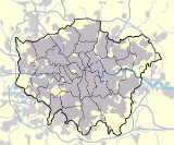
Metropolitan area
The term metropolitan area refers to a region consisting of a densely populated urban core and its less-populated surrounding territories, sharing industry, infrastructure, and housing. A metropolitan area usually encompasses multiple jurisdictions and municipalities: neighborhoods, townships,...
surrounding London
London
London is the capital city of :England and the :United Kingdom, the largest metropolitan area in the United Kingdom, and the largest urban zone in the European Union by most measures. Located on the River Thames, London has been a major settlement for two millennia, its history going back to its...
, England
England
England is a country that is part of the United Kingdom. It shares land borders with Scotland to the north and Wales to the west; the Irish Sea is to the north west, the Celtic Sea to the south west, with the North Sea to the east and the English Channel to the south separating it from continental...
from which it is practical to commute
Commuting
Commuting is regular travel between one's place of residence and place of work or full time study. It sometimes refers to any regular or often repeated traveling between locations when not work related.- History :...
to work in the capital. It is alternatively known as the Greater South East, the London metropolitan area or the Southeast metropolitan area. It should not be confused with Greater London
Greater London
Greater London is the top-level administrative division of England covering London. It was created in 1965 and spans the City of London, including Middle Temple and Inner Temple, and the 32 London boroughs. This territory is coterminate with the London Government Office Region and the London...
or the Greater London Urban Area
Greater London Urban Area
The Greater London Urban Area is the conurbation or continuous urban area based around London, England, as defined by the Office for National Statistics. It had an estimated population of 8,505,000 in 2005 and occupied an area of at the time of the 2001 census. It includes most of Greater London,...
.
The boundaries are not fixed; they expand as transport options improve and affordable housing moves further away from London.
Unanswered Questions
Discussions