
Lodsworth
Encyclopedia
Lodsworth is a small village and civil parish
in the Chichester
district of West Sussex
, England
. It is situated between Midhurst
and Petworth
, half a mile north of the A272 road. It lies within the Sussex Downs Area of Outstanding Natural Beauty
, just to the north of the valley of the River Rother
, and a tributary stream the River Lod
runs close to the east end of the village.
In the 2001 census the parish covered 12.46 km² and had 282 households with a total population of 690. 298 residents were economically active. The parish is a long thin strip running north to south, from the slopes of Blackdown
in the north to Gallows Hill on the border with Graffham
south of the River Rother. It includes the hamlet of Lickfold, with a pub beside the River Lod
and a triangular green where the road to the top of Bexley Hill meets the Lodsworth to Haslemere
road. South of the village there are more houses, a pub and a small factory at Halfway Bridge on the A272.
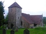
It has a small Anglican church, Saint Peter's, a pub, the Hollist Arms, and a village hall.
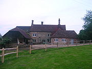 Built by the Bishop
of London
who owned the Manor
during the Medieval period the Manor House would, when built have been the finest building in the area. The present house is likely to have been the home of the Bishop's steward, who would have administered the manor. Manorial courts would have been held there and there was a basement dungeon
to hold prisoners. The Manor was held as a "Liberty" by the Bishop, making it independent of the county justice system, so even the most serious crimes would have been tried there, and executions would have been carried out at Gallows Hill on the border with Graffham
. Archaeological work during the autumn of 2002 revealed the fondations of a 7 metre extension to the east of the building, with 1 metre foundations resting on solid rock which may have supported a tower. It is likely that there was a great hall to the south of the building.
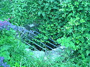 The spring near St Peters church was a place of pilgrimage
in the Middle Ages, especially for people with eye problems, and a source of revenue for the village. The well is located a few metres along a footpath that joins the lower junction of Church Lane and Rectory Lane.
meaning Lod or Loda’s enclosure, but little is known for certain of the village until after the Norman conquest of England
, when the area was given to Robert de Montgomerie, Earl of Shrewsbury
. There is no certain reference to Lodsworth in the Domesday Book
, although it may have been regarded as part of Grittenham, now part of Tillington
but then a much larger settlement. Lodsworth was part of the hundred of Easebourne, a Saxon administrative area.
In 1119 Richard de Belmas, the Bishop of London
, was given the manor by the Montgomerie family; and Lodsworth was made a Liberty by Royal Charter of King Henry I
. This unusual status made the manor independent from the county and hundred legal system so that even the most serious crimes were tried at the manorial court held at the manor house. The manor was run by the Bishop of London’s representative the Sheriff who lived at the manor house. Villagers were exempt from tolls at markets and fairs in other parishes, and all income from the manor went straight to the bishop. The manor must have been a valuable source of income to the bishop with revenue from pilgrims to St. Peter’s well and probably from stone quarrying, and the status of Liberty was vigorously defended and was reaffirmed by several kings, the last being Henry VI
.
coppice on Bexley Hill, cut in rotation to produce fence materials, and areas of oak
and conifers.
There is a large timberyard and sawmill at Lodsbridge, south of Halfway Bridge and a small factory at the old watermill
site at Halfway Bridge.
The first transport other than pack horses or horse carts was in 1795 when the Rother Navigation was built from Pulborough
to Midhurst
, allowing canal barges to reach the wharf
at Lodsbridge. This was used mainly to bring chalk
and coal
in and to export timber. The railway line from Pulborough
to Petworth
was extended to Midhurst
in the 1860s with stations at Selham and Midhurst.
Civil parish
In England, a civil parish is a territorial designation and, where they are found, the lowest tier of local government below districts and counties...
in the Chichester
Chichester (district)
Chichester is a largely rural local government district in West Sussex, England. Its council is based in the city of Chichester.-History:The district was formed on 1 April 1974, under the Local Government Act 1972, as a merger of the municipal borough of Chichester and the Rural Districts of...
district of West Sussex
West Sussex
West Sussex is a county in the south of England, bordering onto East Sussex , Hampshire and Surrey. The county of Sussex has been divided into East and West since the 12th century, and obtained separate county councils in 1888, but it remained a single ceremonial county until 1974 and the coming...
, England
England
England is a country that is part of the United Kingdom. It shares land borders with Scotland to the north and Wales to the west; the Irish Sea is to the north west, the Celtic Sea to the south west, with the North Sea to the east and the English Channel to the south separating it from continental...
. It is situated between Midhurst
Midhurst
Midhurst is a market town and civil parish in the Chichester district of West Sussex, England, with a population of 4,889 in 2001. The town is situated on the River Rother and is home to the ruin of the Tudor Cowdray House and the stately Victorian Cowdray Park...
and Petworth
Petworth
Petworth is a small town and civil parish in the Chichester District of West Sussex, England. It is located at the junction of the A272 east-west road from Heathfield to Winchester and the A283 Milford to Shoreham-by-Sea road. Some twelve miles to the south west of Petworth along the A285 road...
, half a mile north of the A272 road. It lies within the Sussex Downs Area of Outstanding Natural Beauty
Area of Outstanding Natural Beauty
An Area of Outstanding Natural Beauty is an area of countryside considered to have significant landscape value in England, Wales or Northern Ireland, that has been specially designated by the Countryside Agency on behalf of the United Kingdom government; the Countryside Council for Wales on...
, just to the north of the valley of the River Rother
River Rother (Western)
The River Rother is a river which flows for thirty miles from Empshott in Hampshire to Stopham in West Sussex, where it joins the River Arun. It should not be confused with the River Rother, in East Sussex....
, and a tributary stream the River Lod
River Lod, West Sussex
The River Lod is a short river draining about of north west Sussex. The source is on Marley Heights near Haslemere, about 140 metres above sea level. From here it flows west past Linchmere, then south to Furnace Pond, where iron cannon were cast during the English Civil War...
runs close to the east end of the village.
In the 2001 census the parish covered 12.46 km² and had 282 households with a total population of 690. 298 residents were economically active. The parish is a long thin strip running north to south, from the slopes of Blackdown
Blackdown, Sussex
Blackdown, or Black Down, is the highest hill in the historic county of Sussex, at 280 metres , and is second only to Leith Hill in southeastern England....
in the north to Gallows Hill on the border with Graffham
Graffham
Graffham is a village and civil parish in West Sussex, England, situated on the northern escarpment of the South Downs. It is made up of the village of Graffham and the hamlet of Selham...
south of the River Rother. It includes the hamlet of Lickfold, with a pub beside the River Lod
River Lod, West Sussex
The River Lod is a short river draining about of north west Sussex. The source is on Marley Heights near Haslemere, about 140 metres above sea level. From here it flows west past Linchmere, then south to Furnace Pond, where iron cannon were cast during the English Civil War...
and a triangular green where the road to the top of Bexley Hill meets the Lodsworth to Haslemere
Haslemere
Haslemere is a town in Surrey, England, close to the border with both Hampshire and West Sussex. The major road between London and Portsmouth, the A3, lies to the west, and a branch of the River Wey to the south. Haslemere is approximately south-west of Guildford.Haslemere is surrounded by hills,...
road. South of the village there are more houses, a pub and a small factory at Halfway Bridge on the A272.
It has a small Anglican church, Saint Peter's, a pub, the Hollist Arms, and a village hall.
The Manor House
Bishop
A bishop is an ordained or consecrated member of the Christian clergy who is generally entrusted with a position of authority and oversight. Within the Catholic Church, Eastern Orthodox, Oriental Orthodox Churches, in the Assyrian Church of the East, in the Independent Catholic Churches, and in the...
of London
London
London is the capital city of :England and the :United Kingdom, the largest metropolitan area in the United Kingdom, and the largest urban zone in the European Union by most measures. Located on the River Thames, London has been a major settlement for two millennia, its history going back to its...
who owned the Manor
Manorialism
Manorialism, an essential element of feudal society, was the organizing principle of rural economy that originated in the villa system of the Late Roman Empire, was widely practiced in medieval western and parts of central Europe, and was slowly replaced by the advent of a money-based market...
during the Medieval period the Manor House would, when built have been the finest building in the area. The present house is likely to have been the home of the Bishop's steward, who would have administered the manor. Manorial courts would have been held there and there was a basement dungeon
Dungeon
A dungeon is a room or cell in which prisoners are held, especially underground. Dungeons are generally associated with medieval castles, though their association with torture probably belongs more to the Renaissance period...
to hold prisoners. The Manor was held as a "Liberty" by the Bishop, making it independent of the county justice system, so even the most serious crimes would have been tried there, and executions would have been carried out at Gallows Hill on the border with Graffham
Graffham
Graffham is a village and civil parish in West Sussex, England, situated on the northern escarpment of the South Downs. It is made up of the village of Graffham and the hamlet of Selham...
. Archaeological work during the autumn of 2002 revealed the fondations of a 7 metre extension to the east of the building, with 1 metre foundations resting on solid rock which may have supported a tower. It is likely that there was a great hall to the south of the building.
St. Peter's Well
Pilgrimage
A pilgrimage is a journey or search of great moral or spiritual significance. Typically, it is a journey to a shrine or other location of importance to a person's beliefs and faith...
in the Middle Ages, especially for people with eye problems, and a source of revenue for the village. The well is located a few metres along a footpath that joins the lower junction of Church Lane and Rectory Lane.
History
The name Lodsworth is Anglo-SaxonOld English language
Old English or Anglo-Saxon is an early form of the English language that was spoken and written by the Anglo-Saxons and their descendants in parts of what are now England and southeastern Scotland between at least the mid-5th century and the mid-12th century...
meaning Lod or Loda’s enclosure, but little is known for certain of the village until after the Norman conquest of England
Norman conquest of England
The Norman conquest of England began on 28 September 1066 with the invasion of England by William, Duke of Normandy. William became known as William the Conqueror after his victory at the Battle of Hastings on 14 October 1066, defeating King Harold II of England...
, when the area was given to Robert de Montgomerie, Earl of Shrewsbury
Shrewsbury
Shrewsbury is the county town of Shropshire, in the West Midlands region of England. Lying on the River Severn, it is a civil parish home to some 70,000 inhabitants, and is the primary settlement and headquarters of Shropshire Council...
. There is no certain reference to Lodsworth in the Domesday Book
Domesday Book
Domesday Book , now held at The National Archives, Kew, Richmond upon Thames in South West London, is the record of the great survey of much of England and parts of Wales completed in 1086...
, although it may have been regarded as part of Grittenham, now part of Tillington
Tillington
Tillington may refer to more than one place in England:*Tillington, Herefordshire*Tillington, Staffordshire*Tillington, West Sussex...
but then a much larger settlement. Lodsworth was part of the hundred of Easebourne, a Saxon administrative area.
In 1119 Richard de Belmas, the Bishop of London
Bishop of London
The Bishop of London is the ordinary of the Church of England Diocese of London in the Province of Canterbury.The diocese covers 458 km² of 17 boroughs of Greater London north of the River Thames and a small part of the County of Surrey...
, was given the manor by the Montgomerie family; and Lodsworth was made a Liberty by Royal Charter of King Henry I
Henry I of England
Henry I was the fourth son of William I of England. He succeeded his elder brother William II as King of England in 1100 and defeated his eldest brother, Robert Curthose, to become Duke of Normandy in 1106...
. This unusual status made the manor independent from the county and hundred legal system so that even the most serious crimes were tried at the manorial court held at the manor house. The manor was run by the Bishop of London’s representative the Sheriff who lived at the manor house. Villagers were exempt from tolls at markets and fairs in other parishes, and all income from the manor went straight to the bishop. The manor must have been a valuable source of income to the bishop with revenue from pilgrims to St. Peter’s well and probably from stone quarrying, and the status of Liberty was vigorously defended and was reaffirmed by several kings, the last being Henry VI
Henry VI of England
Henry VI was King of England from 1422 to 1461 and again from 1470 to 1471, and disputed King of France from 1422 to 1453. Until 1437, his realm was governed by regents. Contemporaneous accounts described him as peaceful and pious, not suited for the violent dynastic civil wars, known as the Wars...
.
Transport and industry
Agriculture and Forestry use most of the land area. There is arable cropping, dairying and other grazing livestock. There are large areas of chestnutChestnut
Chestnut , some species called chinkapin or chinquapin, is a genus of eight or nine species of deciduous trees and shrubs in the beech family Fagaceae, native to temperate regions of the Northern Hemisphere. The name also refers to the edible nuts they produce.-Species:The chestnut belongs to the...
coppice on Bexley Hill, cut in rotation to produce fence materials, and areas of oak
Oak
An oak is a tree or shrub in the genus Quercus , of which about 600 species exist. "Oak" may also appear in the names of species in related genera, notably Lithocarpus...
and conifers.
There is a large timberyard and sawmill at Lodsbridge, south of Halfway Bridge and a small factory at the old watermill
Watermill
A watermill is a structure that uses a water wheel or turbine to drive a mechanical process such as flour, lumber or textile production, or metal shaping .- History :...
site at Halfway Bridge.
The first transport other than pack horses or horse carts was in 1795 when the Rother Navigation was built from Pulborough
Pulborough
Pulborough is a large village and civil parish in the Horsham district of West Sussex, England, with some 5,000 inhabitants. It is located almost centrally within West Sussex and is south west of London. It is at the junction of the north-south A29 and the east-west roads.The village is near the...
to Midhurst
Midhurst
Midhurst is a market town and civil parish in the Chichester district of West Sussex, England, with a population of 4,889 in 2001. The town is situated on the River Rother and is home to the ruin of the Tudor Cowdray House and the stately Victorian Cowdray Park...
, allowing canal barges to reach the wharf
Wharf
A wharf or quay is a structure on the shore of a harbor where ships may dock to load and unload cargo or passengers.Such a structure includes one or more berths , and may also include piers, warehouses, or other facilities necessary for handling the ships.A wharf commonly comprises a fixed...
at Lodsbridge. This was used mainly to bring chalk
Chalk
Chalk is a soft, white, porous sedimentary rock, a form of limestone composed of the mineral calcite. Calcite is calcium carbonate or CaCO3. It forms under reasonably deep marine conditions from the gradual accumulation of minute calcite plates shed from micro-organisms called coccolithophores....
and coal
Coal
Coal is a combustible black or brownish-black sedimentary rock usually occurring in rock strata in layers or veins called coal beds or coal seams. The harder forms, such as anthracite coal, can be regarded as metamorphic rock because of later exposure to elevated temperature and pressure...
in and to export timber. The railway line from Pulborough
Pulborough
Pulborough is a large village and civil parish in the Horsham district of West Sussex, England, with some 5,000 inhabitants. It is located almost centrally within West Sussex and is south west of London. It is at the junction of the north-south A29 and the east-west roads.The village is near the...
to Petworth
Petworth
Petworth is a small town and civil parish in the Chichester District of West Sussex, England. It is located at the junction of the A272 east-west road from Heathfield to Winchester and the A283 Milford to Shoreham-by-Sea road. Some twelve miles to the south west of Petworth along the A285 road...
was extended to Midhurst
Midhurst
Midhurst is a market town and civil parish in the Chichester district of West Sussex, England, with a population of 4,889 in 2001. The town is situated on the River Rother and is home to the ruin of the Tudor Cowdray House and the stately Victorian Cowdray Park...
in the 1860s with stations at Selham and Midhurst.
Notable residents
- Sir Ranulph FiennesRanulph FiennesSir Ranulph Twisleton-Wykeham-Fiennes, 3rd Baronet, OBE , better known as Ranulph Fiennes, is a British adventurer and holder of several endurance records. He is also a prolific writer. Fiennes served in the British Army for eight years including a period on counter-insurgency service while...
, soldier and adventurer. - Ernest H. Shepard, the illustrator of the Winnie the Pooh stories and The Wind in the WillowsThe Wind in the WillowsThe Wind in the Willows is a classic of children's literature by Kenneth Grahame, first published in 1908. Alternately slow moving and fast paced, it focuses on four anthropomorphised animal characters in a pastoral version of England...
- Barbara WardBarbara WardBarbara Mary Ward , in later life Baroness Jackson of Lodsworth, was a British economist and writer interested in the problems of developing countries. She urged Western governments to share their prosperity with the rest of the world and in the 1960s turned her attention to environmental...
, (Baroness Jackson of Lodsworth), economist, writer, and humanitarian. - Michael BaigentMichael BaigentMichael Baigent is an author and speculative theorist who co-wrote a number of books that question mainstream perceptions of history and the life of Jesus. He is best known as co-writer of the book The Holy Blood and the Holy Grail....
, Author, historian. Co-writer of The Holy Blood and the Holy GrailThe Holy Blood and the Holy GrailThe Holy Blood and the Holy Grail is a book by Michael Baigent, Richard Leigh, and Henry Lincoln....
.
Further reading
- Martin Hepworth and A. E. Marshall, Lodsworth: the Story of an English Village. Singleton : The Weald and Downland Open-Air Museum, 1995.
- John Rickman, The Land of Lod
- P. A. L. Vine, London's Lost Route to Midhurst: the Earl of Egremont's Navigation and the building of the Petworth Canal. Stroud: Sutton, 1995 ISBN 0750909684