

Location hypotheses of Atlantis
Encyclopedia
Location hypotheses of Atlantis are various proposed real-world settings for the island of Atlantis
, (Ἀτλαντὶς νῆσος) a lost civilization mentioned in Plato
's dialogues Timaeus
and Critias
, written about 360 B.C. In these dialogues, a character named Critias
claims that an island called Atlantis
was swallowed by the sea about 9,200 years previously. This story was passed down to him through his grandfather, Dropides who in turn got it from Solon
, the famous Athenian
lawmaker who translated it from the Egyptian language. Plato's dialogues locate the island in the Atlantic Pelagos “Atlantic Sea”, "in front of" the Pillars of Hercules
(Ηράκλειες Στήλες) and facing a district called modern Gades or Gadira (Gadiron), a location that many modern scholars associate with modern Gibraltar
; however various locations have been proposed.

 Most theories of the placement of Atlantis center on the Mediterranean, influenced largely by the geographical location of Greece
from which the story is derived
.
is a region in modern day southern Spain which once included the "lost" city of Tartessos
, which disappeared in the 6th century BC
. The Tartessians were traders known to the Ancient Greeks who knew of their legendary king Arganthonios
. The Andalusian hypothesis was originally developed by the Spanish author Juan de Mariana and the Dutch author Johannes van Gorp (Goropius Becanus), both of the 16th century, later by Jose Pellicer de Ossau y Tovar in 1673, who suggested that the metropolis of Atlantis was between the islands Mayor and Menor, located almost in the center of the Doñana Marshes, and expanded upon by Juan Fernández Amador y de los Ríos in 1919, who suggested that the metropolis of Atlantis was located precisely where today are the 'Marismas de Hinojo'. These claims were made again in 1922 by the German author Adolf Schulten
, and further propagated by Otto Jessen, Richard Hennig, Victor Berard, and Elena Wishaw in the 1920s. The suggested locations in Andalusia lie outside the Pillars of Hercules, and therefore beyond but close to the Mediterranean itself.
In 2005, based upon the work of Adolf Schulten, the German teacher Werner Wickboldt also claimed this to be the location of Atlantis. Wickboldt suggested that the war of the Atlanteans refers to the war of the Sea Peoples
who attacked the Eastern Mediterranean countries around 1200 BC and that the Iron Age
city of Tartessos may have been built at the site of the ruined Atlantis. In 2000, Georgeos Diaz-Montexano published an article explaining his belief that Atlantis was located somewhere between Andalusia and Morocco. An Andalusian location was also supported by Rainer W. Kühne in his article that appeared in the journal Antiquity
. Kühne's theory says: "Good fiction imitates facts. Plato declared that his Atlantis tale is philosophical fiction invented to describe his fictitious ideal state in the case of war. Kühne suggests that Plato has used three historical elements for this tale. (i) Greek tradition on Mycenaean Athens for the description of ancient Athens, (ii) Egyptian records on the wars of the Sea Peoples for the description of the war of the Atlanteans, and (iii) oral tradition from Syracuse about Tartessos for the description of the city and geography of Atlantis." According to Wickboldt, Satellite images show two rectangular shapes on the tops of two small elevations inside the marsh of Doñana which he hypothesizes are the "temple of Poseidon
" and "the temple of Cleito and Poseidon".
On satellite images parts of several "rings" are recognizable, similar in their proportion with the ring system by Plato. It is not known if any of these shapes are natural or manmade and archaeological excavations are planned. Geologists have shown that the Doñana National Park
experienced intense erosion from 4000 BC until 9th century AD, where it became a marine environment. For thousands of years until the Medieval Age, all that occupied the area of the modern Marshes Doñana was a gulf or inland sea-arm, but there was not even a small island with sufficient space to house a small village.
In 2011, a team led by Richard Freund claimed to have found strong evidence for the location in Doñana National Park based on underground and underwater surveys, and the existence of what they characterized as "memorial cities" rebuilt in Atlantis's image.
Spanish scientists have dismissed Freund's claims claiming that he was sensationalising their work. The anthropologist Juan Villarías-Robles, who works with the Spanish National Research Council, said "Richard Freund was a newcomer to our project and appeared to be involved in his own very controversial issue concerning King Solomon's search for ivory and gold in Tartessos, the well documented settlement in the Donaña area established in the first millennium BC" and described his claims as 'fanciful'.
Simcha Jacobovici
, involved in the production of a documentary on Freund's work for the National Geographic Channel
, stated that the biblical Tarshish
(which he believes is the same as Tartessos
) was Atlantis, and that "Atlantis was hiding in the Tanach". Aren Maeir
, a professor of archeology at Bar-Ilan University said “a lot of people have made many crazy claims about Atlantis – it’s one of those classic places where you have a lunatic fringe looking for all types of things. And Richard Freund is known as someone who makes ‘sensational’ finds. I would say that I am exceptionally skeptical about the thing, but I wouldn’t discount it 100% until I see the details, which haven’t been published as far as I know...every few years we hear something like this from him... And the fact that it’s on National Geographic doesn’t mean much. Unfortunately, over the past years they’ve had many questionable programs.".
. Before 5500 BC, a great plain lay in the northwest at a former freshwater-lake. In 5510 BC, rising sea level topped the barrier at today's Bosporus
. They identify the Pillars of Hercules
with the Strait of Bosporus
. They gave no explanation how the ships of the merchants coming from all over the world had arrived at the harbour of Atlantis when it was 350 feet below global sea-level.
They claim Oreichalcos means the obsidian
stone that used to be a cash-equivalent at that time and was replaced by the spondylus
shell around 5500 BC, which would suit the red, white, black motif. The geocatastrophic event led to the neolithic
diaspora in Europe, also beginning 5500 BC.
In 2000, the Guardian reported that Robert Ballard
, in a small submarine, found remains of human habitation around 300 feet underwater in the Black Sea off the north coast of Turkey. The area flooded around 5000 BC. This flood is also believed to have inspired the Biblical
story of Noah's Ark
known as the Black Sea deluge theory
.
Another candidate bordering the Black Sea, suggested by Hasan Umur in the 1940s, would be Ancomah, a legendary place near Trabzon
.
 The theory that Thera has been the site of the capital of Atlantis has been suggested by Angelos Galanopoulos in 1960.
Soon after the discovery of the Minoan civilization
at Knossos
on Crete
by Sir Arthur Evans
in 1900, theories linking the disappearance of this advanced empire with the destruction of Atlantis were proposed by K. T. Frost in 1913 and E. S. Balch in 1917. This theory was revived by Spyridon Marinatos in 1950 and P. B. S. Andrews in 1967. More recent archaeological, seismological
, and vulcanological evidence
(Recent arguments for Akrotiri being Atlantis have been popularized on television in shows such as The History Channel
show Lost Worlds episode "Atlantis") has expanded the asserted connection of Crete
, the island of Santorini
, and the Minoan civilization
with Plato's description of Atlantis. Evidence said to advance this idea includes:
city of Helike
in 373 BC, i.e. while Plato
was alive, may have been the inspiration for a totally fictional story about Atlantis. The claim that Helike
is the inspiration for Plato's Atlantis is also supported by Dora Katsonopoulou and Steven Soter.
did indeed gather the story on his travels, but in Lydia
, not Egypt
as Plato states; that Atlantis is identical with Tantalis, the city of Tantalus
in Asia Minor, which was (in a similar tradition known to the Greeks) said to have been destroyed by an earthquake; that the legend of Atlantis' conquests in the Mediterranean is based on the revolt by King Madduwattas of Zippasla against Hittite
rule; that Zippasla is identical with Sipylus, where Greek tradition placed Tantalis; and that the now vanished lake to the north of Mount Sipylus was the site of the city.
within the Cyprus Basin. In his book and on his web site, he argues that images prepared from sonar data of the sea bottom of the Cyprus Basin southeast of Cyprus
show features resembling man-made structures on it at depths of 1,500 meters. He interprets these features as being artificial structures that are part of the lost city of Atlantis as described by Plato
. According to his ideas, several characteristics of Cyprus, including the presence of copper
and extinct Cyprus Dwarf Elephant
s and local place names and festivals (Kataklysmos), support his identification of Cyprus as once being part of Atlantis. As with many other theories concerning the location of Atlantis, Sarmast speculates that its destruction by catastrophic flooding is reflected in the story of Noah's Flood in Genesis.
In part, Sarmast bases his claim that Atlantis can be found offshore of Cyprus beneath 0.9 mile (1.5 km) of water on an abundance of evidence that the Mediterranean Sea dried up during the Messinian Salinity Crisis
when its level dropped by 2 to 3 miles (3.2 to 4.9 km) below the level of the Atlantic Ocean
as the result of tectonic uplift blocking the inflow of water through Strait of Gibraltar
. Separated from the Atlantic Ocean, the Mediterranean Sea either partly or completely dried up as the result of evaporation. As a result, its formerly submerged bottom turned into a desert with large saline and brackish lakes. This area all was flooded when a ridge collapsed allowing the catastrophic flooding of through the Straits of Gibraltar. However, Sarmast disagrees with mainstream geologists, oceanographers, and paleontologists in arguing that the closing of the Straits of Gibraltar; the desiccation
and subaerial exposure of the floor of the Mediterranean Sea; and its catatstrophic flooding has occurred "forty times or more times in its long and turbulent existence" and that "the age of each of these events is unknown." In the same interview, he also contradicts what mainstream geologists, oceanographers, and paleontologists argue in claiming that "Scientists know that roughly 18,000 years ago, there was not just one Mediterranean Sea, but three." However, he does not specify who these scientists are; nor does he cite peer-reviewed scientific literature that supports this claim.
Marine and other geologists, who have also studied the bottom of the Cyprus basin, and professional archaeologists completely disagree with his interpretations. Investigations by Dr. C. Hübscher of the Institut für Geophysik, Universität Hamburg, Germany, and others of the salt tectonics and mud volcanism within the Cyprus Basin, eastern Mediterranean Sea, demonstrated that the features which Sarmast interprets to be Atlantis consist only of a natural compressional fold caused by local salt tectonics and a slide scar with surficial compressional folds at the downslope end and sides of the slide. This research collaborates seismic data shown and discussed in the Atlantis: New Revelations 2-hour Special episode of Digging for the Truth
, a History Channel documentary television series. Using reflection seismology
, this documentary demonstrated techniques that what Sarmast interpreted to be artificial walls are natural tectonic landforms.
Furthermore, the interpretation of the age and stratigraphy of sediments blanketing the bottom of the Cyprus Basin from sea bottom cores containing Pleistocene and older marine sediments and thousands of kilometers of seismic lines from the Cyprus and adjacent basins clearly demonstrates that the Mediterranean Sea last dried up during the Messinian Salinity Crisis
between 5.59 and 5.33 million years ago. For example, research conducted south of Cyprus as part of Leg 160 of the Ocean Drilling Project recovered from Sites 963, 965, and 966 cores of sediments underlying the bottom of the Mediterranean Sea at depths as shallow as 470, 1506, and 1044 meters (1540, 4940, and 3420 ft) below sea level. Thus, these cores came from parts of sea bottom of the eastern Mediterranean Sea that either lie above or at the depth of Sarmast's Atlantis, which lies at depths between 1460 and 1510 meters (4820 and 4950 ft) below mean sea level. These cores provide a detailed and continuous record of sea level that demonstrates that for millions of years at least during the entire Pliocene
, Pleistocene
, and Holocene
epochs that the feature that Sarmast interprets to be Atlantis and its adjacent sea bottom were always submerged below sea level. Therefore, the entire Cyprus Basin, including the ridge where Sarmast claims that Atlantis is located, has been submerged beneath the Mediterranean Sea for millions of years. Since its formation, the sea bottom feature identified by Sarmast as “Atlantis” has always been submerged beneath over a kilometer of water.
 Jaime Manuschevich argues that the real place of the mythical civilization is the territory that today corresponds to Israel
and Sinai, and that this region was an island in the Great Rift Valley
, surrounded by the Jezreel Valley
on the north, the Dead Sea
and Red Sea
on the east and the Gulf of Suez
and the Mediterranean Sea
on the west until 5600 BC. In addition, Manuschevich proposes that Atlantean civilization corresponds to the Natufian peoples, the first food-producing people, whose main political and harbor center was Jericho
. These people lived in the region in the dates established by Plato (11,600 BC).
, being situated in the dividing line between the western and eastern Mediterranean sea
, and being the home to the oldest man-made structures in the world
, is considered a possible location of Atlantis both by some current researchers and by Maltese amateur enthusiasts.
In Malta: Echoes of Plato’s Island (2000), Anton Mifsud, Simon Mifsud, Chris Agius Sultana and Charles Savona Ventura catalogues the many archaeological sites and ancient remains in Malta that could be related to Atlantis.
In Malta fdal Atlantis (Maltese remains of Atlantis) (2002), Francis Galea writes about several older studies and hypotheses, particularly that of Maltese architect Giorgio Grongnet, who in 1854 claimed that the Maltese Islands are the remnants of Atlantis.
movement (a similar story to Plato's account), that the name "Atlas" may have been derived from "Italos" via the Middle Egyptian language, and Plato's descriptions of the city of Atlantis share several unlikely traits with the sanctuary of the Palici
(Twin brothers, similar procreation myth, low mountain near to plain, two fountains etc.).
"), in which he states that before Eratosthenes
, all the ancient Greek writers located the Pillars of Hercules
on the Strait of Sicily
between Sicily and Tunisia, while only Alexander the Great's conquest of the east obliged Eratosthenes to move the pillars at Gibraltar in his description of the world.
According to his thesis, the Atlantis described by Plato could be identified with Sardinia
. He argues that a tsunami
once hit Sardinia which destroyed the enigmatic Nuragic civilization
and that the survivors migrated to the nearby Italian peninsula
, founding the Etruscan civilization
(which is now thought to have come from the Eastern Mediterranean).
In April 2005, the theories of the Sergio Frau were debated at a conference organized by UNESCO
in Paris
. At the same time, an exposition of his findings was on display in the UNESCO building.
, a submerged former island in the Strait of Gibraltar
, as the location of Atlantis. The more well-known hypothesis was proposed in a September 2001 issue of Comptes Rendus de l'academie des Sciences by French geologist
Jacques Collina-Girard. The lesser-known hypothesis was first published by Spanish-Cuban investigator Georgeos Díaz-Montexano in an April 2000 issue of Spanish magazine Más Allá de la Ciencia (Beyond Science), and later in August 2001 issues of Spanish magazines El Museo (The Museum) and Año Cero (Year Zero). The origin of Collina-Girard's hypothesis is disputed, with Díaz-Montexano claiming it as plagiarism of his own earlier hypothesis, and Collina-Girard denying any plagiarism. Both individuals claim the other's hypothesis is pseudoscience
.
Collina-Girard's hypothesis states that during the most recent Glacial Maximum of the Ice Age
sea level was 135 m below its current level, narrowing the Gibraltar Strait and creating a small half-enclosed sea measuring 70 km by 20 km between the Mediterranean Sea
and Atlantic Ocean
. The Spartel Bank formed an archipelago in this small sea with the largest island measuring about 10 to 12 kilometers across. With rising ocean levels the island began to slowly shrink, but then at around 9400 BC (11,400 years ago) there was an accelerated sea level rise of 4 meters per century known as Meltwater Pulse 1A
, which drowned the top of the main island. The occurrence of a great earthquake and tsunami in this region, similar to the 1755 Lisbon earthquake (magnitude 8.5-9) was proposed by marine geophysicist Marc-Andrè Gutscher as offering a possible explanation for the described catastrophic destruction (reference - Gutscher, M.-A., 2005. Destruction of Atlantis by a great earthquake and tsunami? A geological analysis of the Spartel Bank hypothesis. Geology, v. 33, p. 685-688.) . Collina-Girard proposes that the disappearance of this island was recorded in prehistoric Egyptian tradition for 5,000 years until it was written down by the first Egyptian scribes around 4000-3000 BC, and the story then subsequently inspired Plato to write a fictionalized version interpreted to illustrate his own principles.
A detailed review in the Bryn Mawr Classical Review
comments on the discrepancies in Collina-Girard's dates and use of coincidences, concluding that he "has certainly succeeded in throwing some light upon some momentous developments in human prehistory in the area west of Gibraltar. Just as certainly, however, he has not found Plato's Atlantis."
has proposed the hypothesis that Atlantis was in fact the city state of Troy
. He both agrees and disagrees with Rainer W. Kühne: He too believes that the Trojans-Atlanteans were the sea peoples, but only a minor part of them. He proposes that all Greek speaking city states of the Aegean civilization
or Mycenae
constituted the sea peoples and that they destroyed each other's economies in a series of semi-fratricidal wars lasting several decades.
procedure, a variety of geographically relevant indications from Plato's accounts are used to infer the most probable location of Plato's Atlantis Nesos. The outcome of this is the Souss-Massa plain in today's South-West Morocco. This plain is surrounded by the High Atlas, the Anti-Atlas, the Sea of Atlas (Atlantis Thalassa, today's Atlantic Ocean). Because of this isolated position, Hübner argued, this plain was called Atlantis Nesos, the Island of Atlas by ancient Greeks before the Greek Dark Ages
. The Amazigh (Berber) People actually call the Souss-Massa
plain island. Of major archaeological interest is the fact that in the North-West of the Souss-Massa plain a large annular caldera-like geomorphologic structure was discovered. This structure has almost the dimensions of Plato's capital of Atlantis and is covered with hundreds of large and small prehistoric ruins of different types. These ruins were made out of rocks coloured red, white and black. Hübner also shows possible harbour remains, a unusually geomorphological structure, which applies to Plato's description of roofed over docks, which were cut into red, white and black bedrock. These 'docks' are located close to the annular geomorphological structure and close to Cape Ghir, which was named Cape Heracles in antiquity. Hübner also argued, that Agadir is etymologically related to the semitic g-d-r and probably to Plato’s Gadir. The semitic g-d-r means enclosure, fortification and sheep fold. The meaning of enclosure, sheep fold corresponds to the Greek translation of the name Gadeiros (Crit. 114b) which is Eumelos = Rich in Sheep.
 It has been claimed that when Plato wrote of the Ocean of Atlantis, he may have been speaking of the area now called the Atlantic Ocean
. The ocean's name, derived from Greek mythology, means the "Sea of Atlas
". Plato remarked that, in describing the origins of Atlantis, this area was allotted to Poseidon. In Ancient Greek times the terms "Ocean" and "Atlas" both referred to the 'Giant Water' which surrounded the main landmass known at that time by the Greeks, which could be described as Eurafrasia (although this whole supercontinent was far from completely known to the Ancient Greeks), and thus this water mass was considered to be the 'end of the (known) world', for the same reason the name "Atlas" was given to the mountains near the Ocean, the Atlas Mountains
, as they also denoted the 'end of the (known) world'.
located about 900 miles (1500 km) west of the Portuguese coast. Some people believe the islands could be the mountain tops of Atlantis.
Ignatius L. Donnelly, an American congressman, was perhaps the first one to talk about this possible location in his book "Atlantis: The Antediluvian World".
The Azores are steep-sided volcanic seamounts that drop rapidly 1000 meters (about 3300 feet) to a plateau. Cores taken from the plateau and other evidence shows that this area has been an undersea plateau for millions of years. Ancient indicators, i.e. relict beaches
, marine deposits, and wave cut-terraces
, of Pleistocene
shorelines and sea level show that the Azores Islands have not subsided to any significant degree. Instead, they demonstrate that some of these islands have actually risen during the Late and Middle Pleistocene. This is evidenced by relict, Pleistocene wave-cut platforms and beach sediments that now lie well above current sea level. For example, they have been found on Flores Island at elevations of 15-20, 35-45, ~100, and ~250 meters above current sea level.
Ignatius L. Donnelly also makes a connection to the mythical Aztlán
.
in his Essai sur les îles fortunées et l'antique Atlantide proposed that the Canary Islands
, along with the Madeira
, and Azores
, are what remained after Atlantis broke up. Many later authors, i.e. Lewis Spence
in his The Problem of Atlantis, also identified the Canary Islands as part of Atlantis leftover from when it catastrophically sank.
Detailed geomorphic and geologic studies of the Canary Islands clearly demonstrate that over the last 4 million years, they have been steadily uplifted, without any significant periods of subsidence, by geologic processes such as erosional unloading, gravitational unloading, lithospheric flexure induced by adjacent islands, and volcanic underplating. For example, Pliocene
pillow lava
s, which solidified underwater and now exposed on the northeast flanks of Gran Canaria
, have been uplifted between 46 and 143 meters above sea level. Also, marine deposits associated with lavas dated as being 4.1 and 9.3 million years old in Gran Canaria, ca. 4.8 million years old in Fuerteventura
, and ca. 9.8 million years old in Lanzarote
demonstrate that the Canary Islands have for millions of years undergone long term uplift without any significant, much less catastrophic, subsidence. A series of raised, Pleistocene marine terrace
s, which become progressively older with age, on Fuerteventura indicate that it has risen in elevation at about 1.7 cm per thousand years for the past one million years. The elevation of the marine terrace for the highstand of sea level for the last interglacial period shows that this island has experienced neither subsidence nor significant uplift for the past 125,000 years. Within the Cape Verde Islands, the detailed mapping and dating of 16 Pleistocene marine terraces and Pliocene marine conglomerate
found that they have been uplifted throughout most of the Pleistocene and remained relatively stable without any significant subsidence since the last interglacial period. Finally, detailed studies of the sedimentary deposits surrounding the Canary Islands have demonstrated, except for a narrow rim around each island exposed during glacial lowstands of sea level, a complete lack of any evidence for the ocean floor surrounding the Canary Islands having ever been above water.
Detailed studies of the geology of the Le Danois Bank region have refuted the hypothesis proposed by Jorge Maria Ribero-Meneses that the Le Danois Bank was created by the collapse of the northern Cantabrian continental margin about 12,000 years ago. The Le Danois Bank represents part of the continental margin that have been uplifted by thrust faulting when the continental margin overrode oceanic crust during the Paleogene
and Neogene
periods. Along the northern edge of the Le Danois Bank, Precambrian
granulite
and Mesozoic
sedimentary rocks have been thrust northward over Miocene
and Oligocene
marine sediments. The basin separating the Le Danois Bank from the Cantabrian continental margin to the south is a graben
that simultaneously formed as a result of normal faulting associated with the thrust faulting. In addition, marine sediment
s that range in age from lower Pliocene
to Pleistocene
, cover large parts of Le Danois Bank, and fill the basin separating it from the Cantabrian continental margin demonstrate that this bank has been submerged beneath the Bay of Biscay for millions of years.
and that this island was Atlantis. He argues that this Neolithic civilization in Europe
was partially drowned by rising sea levels caused by a comet
impact that caused a pole shift and changed the earth's axis
around 3100 BC.
, Cornwall
, Britain
. The BBC stated that Little Sole Bank, a relatively shallow area, was believed by the team to be the capital of Atlantis. This may have been based on the myth of Lyonesse
.
geographer
Dr. Ulf Erlingsson from Uppsala
University. It hypothesized that the empire of Atlantis refers to the Neolithic
Megalithic tomb culture, based on their similar geographic extent, and deduced that the island of Atlantis then must correspond to Ireland
. Erlingsson found the similarities of size and landscape to be statistically significant, while he rejected his null hypothesis that Plato invented Atlantis as fiction.
Based on this result, the speculation was made that the capital of Atlantis could be connected with Newgrange
, Knowth
, and Tara, Ireland. As regards the sinking of Atlantis, it was suggested that it is a memory from another time and place, notably the Dogger Bank
area. It was an island that sank in the North Sea
about 6100 BC. While the world sea level rose gradually as the Ice Age
ice sheets melted, there was a sudden sea level rise at this time due to the final drainage of Lake Agassiz
. At about the same time a tsunami
from the Storegga Slide
is believed to have devastated the island in the manner described by Plato. (See also entry on North Sea below.)
Other hypotheses place the location of Atlantis between Britain and France on the Celtic Shelf. This hypothesis was first developed by Lewis Spence
and has been recently revived by some oceanographers.
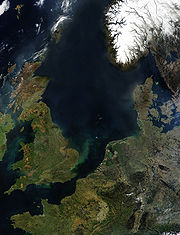 The North Sea
is known to contain lands that were once above water; the medieval town of Dunwich
in East Anglia
, for example, crumbled into the sea. The land area known as "Doggerland
", between England and Denmark, was inundated by a tsunami
around 8200BP (6200BC), caused by a submarine landslide off the coast of Norway
known as the Storegga Slide
, and prehistoric human remains have been dredged up from the Dogger Bank
. Atlantis itself has been identified with the island of Heligoland
off the north-west German coast by the author Jürgen Spanuth, who postulates that it was destroyed during the Bronze Age
around 1200 BC, only to partially re-emerge during the Iron Age. Ulf Erlingsson hypothesized that the island that sank referred to Dogger Bank, and the city itself referred to the Silverpit crater
at the base of Dogger Bank. A book allegedly by Oera Linda
claims that a land called Atland
once existed in the North Sea, but was destroyed in 2194 BC.
.
locates Atlantis in the Baltic sea, at southern part of Finland
where he claims a small community of people lived during the Ice Age
. According to Bock, this was possible due to Gulf Stream
which brought warm water to the Finnish coast. This is a small part of a large saga that he claims has been told in his family through the ages, dating back to the development of language itself. The family saga tells the name Atlantis comes from Swedish words allt-land-is ("all-land-ice") and refers to the last Ice-Age. Thus in the Bock family saga it's more a time period than an exact geographical place. According to this the Atlantis disappeared in 8016 BC when the Ice-Age ended in Finland and the ice melted away.
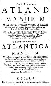 Olaus Rudbeck
wrote Atland
(Atlantica), where he argues that Scandinavia, specifically Sweden
, is identical with Atlantis.
Francisco López de Gómara
, writing in 1552 thought that what Columbus had discovered was the Atlantic Island of Plato.
In 1556 Agustín de Zárate stated that the Americas
was Atlantis which at one time began from the straits of Gibraltar and extended westwards to include North and South America and that it was as a result of Plato that the new continent was discovered. He also said it had all the attributes of the continent described by Plato yet at the same time mentioned that the ancient peoples crossed over by a route from the island of Atlantis. Zarate also mentions that the 9,000 “years” of Plato were 9,000 “months”.
This was also repeated and clarified by historian Pedro Sarmiento de Gamboa
in 1572 in his “History of the Incas”, who by calculation of longitude stated that Atlantis must have stretched from within two leagues of the strait of Gibraltar westwards to include “all the rest of the land from the mouth of the Marañon (Amazon River) and Brazil to the South Sea, which is what they now call America.” He thought the sunken part to be now in the Atlantic Ocean but that it was from this sunken part that the original Indians had come to populate Peru via one continuous land mass. He says that South America was also known by the name of the Isla Atlanticus.
It first appeared as the Atlantic Island (Insula Atlantica) on a map of the New World by cartographer Sebastian Münster
in 1540 and again on the map titled Atlantis Insula by Nicolas Sanson
and son (1669) which identified both North and South America as “Atlantis Insula”, the eastern part of the Atlantic Ocean as “Oceanus Atlanticus” and the western part of the Atlantic Ocean plus the Pacific Ocean as ”Atlanticum Pelagus”. This edition was further embellished with features from the Atlantis legend by his son Guillaume Sanson including the names of the ten kings of Atlantis with Atlas’ portion being in Mexico. Sanson's map supposedly showed what the earth looked like 200,000 years before there were any humans on it.
because he describes a level rectangular-shaped plain which he said lay in the center of the continent, next to the sea and midway along the longest side of the continent. He also described the capital city of Atlantis which was built on a small volcanic island and also called Atlantis. The city lay on the level rectangular plain, five miles from the sea and according to Plato the whole region was high above the level of the ocean sea, rising sheer out of the ocean sea to a great height on that side of the continent. Allen contends that the Altiplano region of Bolivia meets these characteristics.
. He claims in his The last Atlantis Book You'll Ever Have to Read! that the Sanskrit language spoken in the Indian subcontinent
is the progenitor of most world languages, that this explains the meaning of the name "Atlantis", and that this suggests a connection between Mexico and India
and a Mexican location for Atlantis.
, which purportedly shows Antarctica as it would be ice free, suggesting human knowledge of that period. Charles Berlitz
, Erich Von Däniken
and Peter Kolosimo
are some of the popular authors who made this proposal.
More recently Rand and Rose Flem-Ath have proposed this in their book, When the Sky Fell; the theory was revised and made more specific in Rand's work with author Colin Wilson
, in The Atlantis Blueprint (published in 2002). The second work theorized that Atlantis was to be found in Lesser Antarctica, near the coast of the Ross Ice Shelf. A geological theory known as "Earth Crust Displacement" forms the basis of their work. The Atlantis Blueprint uses both scientific and pseudoscientific (such as mere speculation and assumptions) means to back up the theory.
Charles Hapgood
came up with the "Earth Crustal Displacement
theory". Hapgood's theory suggests that Earth's outer crust
is able to move upon the upper mantle layer rapidly up to a distance of 2,000 miles, placing Atlantis in Antarctica, when considering the movements of the crust in the past. It is to be noted that Albert Einstein
was one of the few voices to answer Hapgood's theory. Einstein wrote a preface for Hapgood's book Earth's shifting crust, published in 1958. This theory is particularly popular with Hollow Earth
ers, and can be seen as a mirror of the Hyperborean identification. In his book "Fingerprints of the Gods
", author Graham Hancock
argues for the Earth Crustal Displacement theory in general, and the Atlantis/Antarctica connection specifically, then goes on to propose archaeological exploration of Antarctica in search of Atlantis.
What is now known about the Quaternary
and Holocene
history of Antarctica completely discredits any hypothesis about it being the location of Atlantis. Mapping and dating of the edges of the Antarctic ice sheet during the Last Glacial Maximum
; mapping and dating of glacial erratic
s, till
s, and striations within now ice-free areas; microfossils from post-glacial lake deposits; coring and analysis of glacial tills and marine sediments underlying the Ross
and Wedell seas; coring and analysis of ice cores; and other research has accumulated an enormous amount of data that has disproved the various hypotheses that any sizable part of Antarctica was sufficiently ice-free and temperate in climate during the last 100,000 years and earlier to have supported any civilization. This research soundly refutes Flem-Ath’s proposal that lesser (West) Antarctica was ice-free and temperate prior to 9,600 B.C. (11,600 B.P.)
 The South China Sea
north of Indonesia
and Java Sea
have been advocated as a site for Atlantis. Key to this argument that Sundaland
was the location of Atlantis is that the Ocean of Atlantis refers to the ocean which encircles Eurasia
and Africa
, which was the historical understanding until the time of Christopher Columbus
. Proponents of this idea claim that natives of Sundaland who fled the rising waters or volcanic explosions eventually had contact with Ancient Egypt
ians, who later passed the story onto Plato who gets some but not all of the details correct, including location and time period. The main advocate of this theory is the Brazil
ian professor of nuclear physics
Arysio Nunes dos Santos.
During the Last Glacial Maximum
, what is now known as the Sunda Shelf was the location of a large subaerial coastal plain that was part of Sundaland
. During the Last Glacial Maximum, Sundaland extended northward from Indonesia
to Borneo
and northwestward to the coast of Southeast Asia. Sundaland is quite tectonically stable lacking any known prehistory of any significant, much less cataclysmic, tectonic subsidence. Numerous studies by petroleum and Quaternary geologists have found a complete lack of any evidence for any Neogene
and Quaternary
volcanic activity within the Sunda Shelf despite its proximity to Indonesia.
Detailed studies of late glacial and postglacial sea level rise for this part of the Sunda Shelf demonstrates that the first significant submergence of Sundaland by rising sea level occurred between 14,000 and 15,000 years ago. Periods of abrupt rise in sea level submerged a significant part of Sundaland beneath the South China Sea between 13,000 and 14,000 years ago. Between 14,300 and 14,600 years ago, a period of 300 years, sea level rose 16m (62 feet). Between 12,000 and 13,000 years ago, the submergence of Sundaland by rising sea level was relatively minor. A final period of rapid flooding of Sundaland by the South China Sea occurred between 11,000 to 12,000 years ago. The submergence of Sundaland during this period was minor in extent relative to the area submerged between 13,000 and 14,000 years ago. Evidence for any significant or cataclysmic submergence of Sundaland as the result of tectonic processes is completely lacking.
(1833–1929) wrote a book promoting his belief that the original centre of mankind once sat at the North Pole entitled Paradise Found: The Cradle of the Human Race at the North Pole (1885). In this work Warren placed Atlantis at the North Pole, as well as the Garden of Eden
, Mount Meru, Avalon
and Hyperborea. Warren believed all these mythical lands were folk memories of a former inhabited far northern seat where man was originally created.
Warren's identification of Atlantis with the North Pole was maintained by positioning Atlas
in the far north by mapping out ancient Greek cosmology. Warren equated the primordial Titan Atlas
of Greek mythology who supported the Heavens on his shoulders (or supported the earth on a pillar) to the Atlas described in Plato's dialogue Critias as the first ruler of Atlantis (Critias, 114a). In Warren's view, all the axis mundi
or cosmic-axis of ancient legends (Yggdrasil
, Irminsul
and Atlas' pillar) had to be in the far north "at the top of the world":
Warren noted how Homer
, Virgil
and Hesiod
all placed Atlas or his world pillar at the "ends of the earth", meaning in his view the far northern arctic regions, while Euripides
related Atlas to the Pole Star, so as he concluded:
Therefore in Warren's view Atlantis sat in the far north, at the North Pole, since the Atlas in his ancient Greek cosmological mapping stood in the far northern zenith, under the Pole Star.
COLLINA-GIRARD, J (2009).-L’ATLANTIDE RETROUVEE ? Enquête scientifique autour d’un mythe, Belin-Pour la Science éditeur, Collection Regards, 223 pages. ISSN1773-8016, ISBN978-2-7011-4608-9
COLLINA-GIRARD, J (2001).-L'Atlantide devant le Detroit de Gibraltar ? mythe et géologie. Comptes Rendus de l'Académie des Sciences de Paris, Sciences de la Terre et des Planètes. 333 (2001) 233-240
Atlantis
Atlantis is a legendary island first mentioned in Plato's dialogues Timaeus and Critias, written about 360 BC....
, (Ἀτλαντὶς νῆσος) a lost civilization mentioned in Plato
Plato
Plato , was a Classical Greek philosopher, mathematician, student of Socrates, writer of philosophical dialogues, and founder of the Academy in Athens, the first institution of higher learning in the Western world. Along with his mentor, Socrates, and his student, Aristotle, Plato helped to lay the...
's dialogues Timaeus
Timaeus (dialogue)
Timaeus is one of Plato's dialogues, mostly in the form of a long monologue given by the title character, written circa 360 BC. The work puts forward speculation on the nature of the physical world and human beings. It is followed by the dialogue Critias.Speakers of the dialogue are Socrates,...
and Critias
Critias (dialogue)
Critias, one of Plato's late dialogues, contains the story of the mighty island kingdom Atlantis and its attempt to conquer Athens, which failed due to the ordered society of the Athenians...
, written about 360 B.C. In these dialogues, a character named Critias
Critias
Critias , born in Athens, son of Callaeschrus, was an uncle of Plato, and a leading member of the Thirty Tyrants, and one of the most violent. He was an associate of Socrates, a fact that did not endear Socrates to the Athenian public. He was noted in his day for his tragedies, elegies and prose...
claims that an island called Atlantis
Atlantis
Atlantis is a legendary island first mentioned in Plato's dialogues Timaeus and Critias, written about 360 BC....
was swallowed by the sea about 9,200 years previously. This story was passed down to him through his grandfather, Dropides who in turn got it from Solon
Solon
Solon was an Athenian statesman, lawmaker, and poet. He is remembered particularly for his efforts to legislate against political, economic and moral decline in archaic Athens...
, the famous Athenian
Athens
Athens , is the capital and largest city of Greece. Athens dominates the Attica region and is one of the world's oldest cities, as its recorded history spans around 3,400 years. Classical Athens was a powerful city-state...
lawmaker who translated it from the Egyptian language. Plato's dialogues locate the island in the Atlantic Pelagos “Atlantic Sea”, "in front of" the Pillars of Hercules
Pillars of Hercules
The Pillars of Hercules was the phrase that was applied in Antiquity to the promontories that flank the entrance to the Strait of Gibraltar. The northern Pillar is the Rock of Gibraltar in the British overseas territory of Gibraltar...
(Ηράκλειες Στήλες) and facing a district called modern Gades or Gadira (Gadiron), a location that many modern scholars associate with modern Gibraltar
Gibraltar
Gibraltar is a British overseas territory located on the southern end of the Iberian Peninsula at the entrance of the Mediterranean. A peninsula with an area of , it has a northern border with Andalusia, Spain. The Rock of Gibraltar is the major landmark of the region...
; however various locations have been proposed.
In or close to the Mediterranean
Greece
Greece , officially the Hellenic Republic , and historically Hellas or the Republic of Greece in English, is a country in southeastern Europe....
from which the story is derived
Greek mythology
Greek mythology is the body of myths and legends belonging to the ancient Greeks, concerning their gods and heroes, the nature of the world, and the origins and significance of their own cult and ritual practices. They were a part of religion in ancient Greece...
.
Andalusia
AndalusiaAndalusia
Andalusia is the most populous and the second largest in area of the autonomous communities of Spain. The Andalusian autonomous community is officially recognised as a nationality of Spain. The territory is divided into eight provinces: Huelva, Seville, Cádiz, Córdoba, Málaga, Jaén, Granada and...
is a region in modern day southern Spain which once included the "lost" city of Tartessos
Tartessos
Tartessos or Tartessus was a harbor city and surrounding culture on the south coast of the Iberian peninsula , at the mouth of the Guadalquivir River. It appears in sources from Greece and the Near East starting in the middle of the first millennium BC, for example Herodotus, who describes it as...
, which disappeared in the 6th century BC
6th century BC
The 6th century BC started the first day of 600 BC and ended the last day of 501 BC.Pāṇini, in India, composed a grammar for Sanskrit, in this century or slightly later...
. The Tartessians were traders known to the Ancient Greeks who knew of their legendary king Arganthonios
Arganthonios
Arganthonios was a king of ancient Tartessos .This name, or title, appears to be based on the Indo-European word for silver and money *arģ-, found in Celtiberian arkanta, Old Irish airget, Latin argentum, Sanskrit rajatám. Tartessia and all of Iberia was rich in silver. Similar names Arganthonios...
. The Andalusian hypothesis was originally developed by the Spanish author Juan de Mariana and the Dutch author Johannes van Gorp (Goropius Becanus), both of the 16th century, later by Jose Pellicer de Ossau y Tovar in 1673, who suggested that the metropolis of Atlantis was between the islands Mayor and Menor, located almost in the center of the Doñana Marshes, and expanded upon by Juan Fernández Amador y de los Ríos in 1919, who suggested that the metropolis of Atlantis was located precisely where today are the 'Marismas de Hinojo'. These claims were made again in 1922 by the German author Adolf Schulten
Adolf Schulten
Adolf Schulten was a German historian and archaeologist.Schulten was born in Elberfeld, Rhine Province, and received a Doctorate in Geology from the University of Bonn in 1892. He studied in Italy, Africa and Greece with support from the Institute of Archaeology...
, and further propagated by Otto Jessen, Richard Hennig, Victor Berard, and Elena Wishaw in the 1920s. The suggested locations in Andalusia lie outside the Pillars of Hercules, and therefore beyond but close to the Mediterranean itself.
In 2005, based upon the work of Adolf Schulten, the German teacher Werner Wickboldt also claimed this to be the location of Atlantis. Wickboldt suggested that the war of the Atlanteans refers to the war of the Sea Peoples
Sea Peoples
The Sea Peoples were a confederacy of seafaring raiders of the second millennium BC who sailed into the eastern Mediterranean, caused political unrest, and attempted to enter or control Egyptian territory during the late 19th dynasty and especially during year 8 of Ramesses III of the 20th Dynasty...
who attacked the Eastern Mediterranean countries around 1200 BC and that the Iron Age
Iron Age
The Iron Age is the archaeological period generally occurring after the Bronze Age, marked by the prevalent use of iron. The early period of the age is characterized by the widespread use of iron or steel. The adoption of such material coincided with other changes in society, including differing...
city of Tartessos may have been built at the site of the ruined Atlantis. In 2000, Georgeos Diaz-Montexano published an article explaining his belief that Atlantis was located somewhere between Andalusia and Morocco. An Andalusian location was also supported by Rainer W. Kühne in his article that appeared in the journal Antiquity
Antiquity (journal)
Antiquity is an academic journal dedicated to the subject of archaeology. It publishes four editions a year, covering topics worldwide from all periods. Its current editor is Martin Carver, Emeritus Professor of Archaeology at the University of York....
. Kühne's theory says: "Good fiction imitates facts. Plato declared that his Atlantis tale is philosophical fiction invented to describe his fictitious ideal state in the case of war. Kühne suggests that Plato has used three historical elements for this tale. (i) Greek tradition on Mycenaean Athens for the description of ancient Athens, (ii) Egyptian records on the wars of the Sea Peoples for the description of the war of the Atlanteans, and (iii) oral tradition from Syracuse about Tartessos for the description of the city and geography of Atlantis." According to Wickboldt, Satellite images show two rectangular shapes on the tops of two small elevations inside the marsh of Doñana which he hypothesizes are the "temple of Poseidon
Poseidon
Poseidon was the god of the sea, and, as "Earth-Shaker," of the earthquakes in Greek mythology. The name of the sea-god Nethuns in Etruscan was adopted in Latin for Neptune in Roman mythology: both were sea gods analogous to Poseidon...
" and "the temple of Cleito and Poseidon".
On satellite images parts of several "rings" are recognizable, similar in their proportion with the ring system by Plato. It is not known if any of these shapes are natural or manmade and archaeological excavations are planned. Geologists have shown that the Doñana National Park
Doñana National Park
-Conservation:In 1989 the surroundings of the national park were given more protection when a buffer zone was declared a natural park under the management of the regional government. The two parks, national and natural, have since been classified as a single natural landscape.In 1994 UNESCO...
experienced intense erosion from 4000 BC until 9th century AD, where it became a marine environment. For thousands of years until the Medieval Age, all that occupied the area of the modern Marshes Doñana was a gulf or inland sea-arm, but there was not even a small island with sufficient space to house a small village.
In 2011, a team led by Richard Freund claimed to have found strong evidence for the location in Doñana National Park based on underground and underwater surveys, and the existence of what they characterized as "memorial cities" rebuilt in Atlantis's image.
Spanish scientists have dismissed Freund's claims claiming that he was sensationalising their work. The anthropologist Juan Villarías-Robles, who works with the Spanish National Research Council, said "Richard Freund was a newcomer to our project and appeared to be involved in his own very controversial issue concerning King Solomon's search for ivory and gold in Tartessos, the well documented settlement in the Donaña area established in the first millennium BC" and described his claims as 'fanciful'.
Simcha Jacobovici
Simcha Jacobovici
Simcha Jacobovici is a Canadian film director, producer, free-lance journalist, and writer. He is a three-times Emmy winner for Outstanding Investigative Journalism....
, involved in the production of a documentary on Freund's work for the National Geographic Channel
National Geographic Channel
National Geographic Channel, also commercially abbreviated and trademarked as Nat Geo, is a subscription television channel that airs non-fiction television programs produced by the National Geographic Society. Like History and the Discovery Channel, the channel features documentaries with factual...
, stated that the biblical Tarshish
Tarshish
Tarshish תַּרְשִׁישׁ occurs in the Hebrew Bible with several uncertain meanings:*One of the sons of Javan .* In the Bible Solomon set up a trade with Tarshish and received ivory, apes, and peacocks from Tarshish which are all native to the jungles in India. India's state bird for example is the...
(which he believes is the same as Tartessos
Tartessos
Tartessos or Tartessus was a harbor city and surrounding culture on the south coast of the Iberian peninsula , at the mouth of the Guadalquivir River. It appears in sources from Greece and the Near East starting in the middle of the first millennium BC, for example Herodotus, who describes it as...
) was Atlantis, and that "Atlantis was hiding in the Tanach". Aren Maeir
Aren Maeir
Aren Maeir is a professor at Bar Ilan University and director of the Tell es-Safi/Gath Archaeological Project . Born in 1958 in Rochester, New York, USA, he moved to Israel in 1969 and has lived there since...
, a professor of archeology at Bar-Ilan University said “a lot of people have made many crazy claims about Atlantis – it’s one of those classic places where you have a lunatic fringe looking for all types of things. And Richard Freund is known as someone who makes ‘sensational’ finds. I would say that I am exceptionally skeptical about the thing, but I wouldn’t discount it 100% until I see the details, which haven’t been published as far as I know...every few years we hear something like this from him... And the fact that it’s on National Geographic doesn’t mean much. Unfortunately, over the past years they’ve had many questionable programs.".
Black Sea
German researchers Siegfried and Christian Schoppe locate Atlantis in the Black SeaBlack Sea
The Black Sea is bounded by Europe, Anatolia and the Caucasus and is ultimately connected to the Atlantic Ocean via the Mediterranean and the Aegean seas and various straits. The Bosphorus strait connects it to the Sea of Marmara, and the strait of the Dardanelles connects that sea to the Aegean...
. Before 5500 BC, a great plain lay in the northwest at a former freshwater-lake. In 5510 BC, rising sea level topped the barrier at today's Bosporus
Bosporus
The Bosphorus or Bosporus , also known as the Istanbul Strait , is a strait that forms part of the boundary between Europe and Asia. It is one of the Turkish Straits, along with the Dardanelles...
. They identify the Pillars of Hercules
Pillars of Hercules
The Pillars of Hercules was the phrase that was applied in Antiquity to the promontories that flank the entrance to the Strait of Gibraltar. The northern Pillar is the Rock of Gibraltar in the British overseas territory of Gibraltar...
with the Strait of Bosporus
Bosporus
The Bosphorus or Bosporus , also known as the Istanbul Strait , is a strait that forms part of the boundary between Europe and Asia. It is one of the Turkish Straits, along with the Dardanelles...
. They gave no explanation how the ships of the merchants coming from all over the world had arrived at the harbour of Atlantis when it was 350 feet below global sea-level.
They claim Oreichalcos means the obsidian
Obsidian
Obsidian is a naturally occurring volcanic glass formed as an extrusive igneous rock.It is produced when felsic lava extruded from a volcano cools rapidly with minimum crystal growth...
stone that used to be a cash-equivalent at that time and was replaced by the spondylus
Spondylus
Spondylus is a genus of bivalve molluscs, the only genus in the family Spondylidae. As well as being the systematic or scientific name, Spondylus is also the most often used common name for these animals, though they are also known as thorny oysters or spiny oysters.There are many species of...
shell around 5500 BC, which would suit the red, white, black motif. The geocatastrophic event led to the neolithic
Neolithic
The Neolithic Age, Era, or Period, or New Stone Age, was a period in the development of human technology, beginning about 9500 BC in some parts of the Middle East, and later in other parts of the world. It is traditionally considered as the last part of the Stone Age...
diaspora in Europe, also beginning 5500 BC.
In 2000, the Guardian reported that Robert Ballard
Robert Ballard
Robert Duane Ballard is a former United States Navy officer and a professor of oceanography at the University of Rhode Island who is most noted for his work in underwater archaeology. He is most famous for the discoveries of the wrecks of the RMS Titanic in 1985, the battleship Bismarck in 1989,...
, in a small submarine, found remains of human habitation around 300 feet underwater in the Black Sea off the north coast of Turkey. The area flooded around 5000 BC. This flood is also believed to have inspired the Biblical
Bible
The Bible refers to any one of the collections of the primary religious texts of Judaism and Christianity. There is no common version of the Bible, as the individual books , their contents and their order vary among denominations...
story of Noah's Ark
Noah's Ark
Noah's Ark is a vessel appearing in the Book of Genesis and the Quran . These narratives describe the construction of the ark by Noah at God's command to save himself, his family, and the world's animals from the worldwide deluge of the Great Flood.In the narrative of the ark, God sees the...
known as the Black Sea deluge theory
Black Sea deluge theory
The Black Sea deluge is a hypothesized catastrophic rise in the level of the Black Sea circa 5600 BC due to waters from the Mediterranean Sea breaching a sill in the Bosporus Strait. The hypothesis made headlines when The New York Times published it in December 1996, shortly before it was published...
.
Another candidate bordering the Black Sea, suggested by Hasan Umur in the 1940s, would be Ancomah, a legendary place near Trabzon
Trabzon
Trabzon is a city on the Black Sea coast of north-eastern Turkey and the capital of Trabzon Province. Trabzon, located on the historical Silk Road, became a melting pot of religions, languages and culture for centuries and a trade gateway to Iran in the southeast and the Caucasus to the northeast...
.
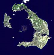
Thera (Santorini)
Soon after the discovery of the Minoan civilization
Minoan civilization
The Minoan civilization was a Bronze Age civilization that arose on the island of Crete and flourished from approximately the 27th century BC to the 15th century BC. It was rediscovered at the beginning of the 20th century through the work of the British archaeologist Arthur Evans...
at Knossos
Knossos
Knossos , also known as Labyrinth, or Knossos Palace, is the largest Bronze Age archaeological site on Crete and probably the ceremonial and political centre of the Minoan civilization and culture. The palace appears as a maze of workrooms, living spaces, and store rooms close to a central square...
on Crete
Crete
Crete is the largest and most populous of the Greek islands, the fifth largest island in the Mediterranean Sea, and one of the thirteen administrative regions of Greece. It forms a significant part of the economy and cultural heritage of Greece while retaining its own local cultural traits...
by Sir Arthur Evans
Arthur Evans
Sir Arthur John Evans FRS was a British archaeologist most famous for unearthing the palace of Knossos on the Greek island of Crete and for developing the concept of Minoan civilization from the structures and artifacts found there and elsewhere throughout eastern Mediterranean...
in 1900, theories linking the disappearance of this advanced empire with the destruction of Atlantis were proposed by K. T. Frost in 1913 and E. S. Balch in 1917. This theory was revived by Spyridon Marinatos in 1950 and P. B. S. Andrews in 1967. More recent archaeological, seismological
Seismology
Seismology is the scientific study of earthquakes and the propagation of elastic waves through the Earth or through other planet-like bodies. The field also includes studies of earthquake effects, such as tsunamis as well as diverse seismic sources such as volcanic, tectonic, oceanic,...
, and vulcanological evidence
(Recent arguments for Akrotiri being Atlantis have been popularized on television in shows such as The History Channel
The History Channel
History, formerly known as The History Channel, is an American-based international satellite and cable TV channel that broadcasts a variety of reality shows and documentary programs including those of fictional and non-fictional historical content, together with speculation about the future.-...
show Lost Worlds episode "Atlantis") has expanded the asserted connection of Crete
Crete
Crete is the largest and most populous of the Greek islands, the fifth largest island in the Mediterranean Sea, and one of the thirteen administrative regions of Greece. It forms a significant part of the economy and cultural heritage of Greece while retaining its own local cultural traits...
, the island of Santorini
Santorini
Santorini , officially Thira , is an island located in the southern Aegean Sea, about southeast from Greece's mainland. It is the largest island of a small, circular archipelago which bears the same name and is the remnant of a volcanic caldera...
, and the Minoan civilization
Minoan civilization
The Minoan civilization was a Bronze Age civilization that arose on the island of Crete and flourished from approximately the 27th century BC to the 15th century BC. It was rediscovered at the beginning of the 20th century through the work of the British archaeologist Arthur Evans...
with Plato's description of Atlantis. Evidence said to advance this idea includes:
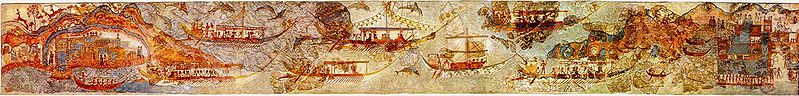
- The Minoan palace and buildings discovered at the digs at KnossosKnossosKnossos , also known as Labyrinth, or Knossos Palace, is the largest Bronze Age archaeological site on Crete and probably the ceremonial and political centre of the Minoan civilization and culture. The palace appears as a maze of workrooms, living spaces, and store rooms close to a central square...
on Crete and at AkrotiriAkrotiri (Santorini)Akrotiri is the name of an excavation site of a Minoan Bronze Age settlement on the Greek island of Santorini, associated with the Minoan civilization due to inscriptions in Linear A, and close similarities in artifact and fresco styles. The excavation is named for a modern Greek village situated...
on the island of Thera have revealed that the Minoans possessed advanced engineering knowledge enabling the construction of three- and four-story buildings with intricate water piping systems, advanced air-flow management, and earthquake-resistant wood and masonry walls. This level of technology was, it is said, far ahead of that found on mainland Greece at the time.
- TheraSantoriniSantorini , officially Thira , is an island located in the southern Aegean Sea, about southeast from Greece's mainland. It is the largest island of a small, circular archipelago which bears the same name and is the remnant of a volcanic caldera...
(also called Santorini) is the site of a massive volcanic calderaCalderaA caldera is a cauldron-like volcanic feature usually formed by the collapse of land following a volcanic eruption, such as the one at Yellowstone National Park in the US. They are sometimes confused with volcanic craters...
with an island at its center. Vulcanologists have determined that the island was engulfed by a volcanic eruption, the Thera eruptionThera eruptionThe Minoan eruption of Thera, also referred to as the Thera eruption or Santorini eruption, was a major catastrophic volcanic eruption with a Volcanic Explosivity Index of 6 or 7 and a Dense-rock equivalent of , which is estimated to have occurred in the mid second millennium BCE. The eruption...
, around 1600 BC. The event, referred to as the Minoan eruption, was among the most powerful eruptions occurring in the history of civilization, ejecting approximately 60 km³ of material, leaving a layer of pumice and ash 10 to 80 meters thick for 20 to 30 km in all directions and having widespread effects across the eastern Mediterranean region. Volcanic events of this magnitude are known to generate tsunamis and archaeological evidence suggests that such a tsunami may have devastated the coastal Minoan settlements on Crete. Plato did not describe a volcanic eruption, although the events he described as "sunk by an earthquake" or "violent earthquakes, and only a flood (in singular)", could perhaps be intrepreted as consistent with such an eruption and the resulting tsunami.
- Plato described quarries on Atlantis where "one kind of stone was white, another black, and a third red", writing that these stones were quarried from the island and used in the construction. Rocks like this are found on Santorini.
- Atlantis was described as being laid out in circular manner, surrounded by three circular concentric pits of seawater and two earth-rings, each connected to the sea by a deep canal. Docks for a large number of ships, with a causeway, were also mentioned. Scientists reconstructing the shape of the island prior to the eruption have concluded that the there was a ring configuration with only one narrow entrance to a larger lagoon with islands inside, much as Plato described. One fresco in the ruins of Akrotiri is believed to be a landscape of the city. It shows a large city in an island in the center of the caldera lagoon.
- The ancient Greek for "between" and "larger" are easily confused in transcription and translation, so "larger than Asia and Libya," might have originally read "between Asia and Libya," which is how Classical Greeks would have described Thera and Crete.
Helike
A. Giovannini has argued that the submergence of the GreekGreece
Greece , officially the Hellenic Republic , and historically Hellas or the Republic of Greece in English, is a country in southeastern Europe....
city of Helike
Helike
Helike was an ancient Greek city that sank at night in the winter of 373 BC. The city was located in Achaea, Northern Peloponnesos, two kilometres from the Corinthian Gulf...
in 373 BC, i.e. while Plato
Plato
Plato , was a Classical Greek philosopher, mathematician, student of Socrates, writer of philosophical dialogues, and founder of the Academy in Athens, the first institution of higher learning in the Western world. Along with his mentor, Socrates, and his student, Aristotle, Plato helped to lay the...
was alive, may have been the inspiration for a totally fictional story about Atlantis. The claim that Helike
Helike
Helike was an ancient Greek city that sank at night in the winter of 373 BC. The city was located in Achaea, Northern Peloponnesos, two kilometres from the Corinthian Gulf...
is the inspiration for Plato's Atlantis is also supported by Dora Katsonopoulou and Steven Soter.
Turkey
Peter James, in his book The Sunken Kingdom, identifies Atlantis with the kingdom of Zippasla. He argues that SolonSolon
Solon was an Athenian statesman, lawmaker, and poet. He is remembered particularly for his efforts to legislate against political, economic and moral decline in archaic Athens...
did indeed gather the story on his travels, but in Lydia
Lydia
Lydia was an Iron Age kingdom of western Asia Minor located generally east of ancient Ionia in the modern Turkish provinces of Manisa and inland İzmir. Its population spoke an Anatolian language known as Lydian....
, not Egypt
Egypt
Egypt , officially the Arab Republic of Egypt, Arabic: , is a country mainly in North Africa, with the Sinai Peninsula forming a land bridge in Southwest Asia. Egypt is thus a transcontinental country, and a major power in Africa, the Mediterranean Basin, the Middle East and the Muslim world...
as Plato states; that Atlantis is identical with Tantalis, the city of Tantalus
Tantalus
Tantalus was the ruler of an ancient western Anatolian city called either after his name, as "Tantalís", "the city of Tantalus", or as "Sipylus", in reference to Mount Sipylus, at the foot of which his city was located and whose ruins were reported to be still visible in the beginning of the...
in Asia Minor, which was (in a similar tradition known to the Greeks) said to have been destroyed by an earthquake; that the legend of Atlantis' conquests in the Mediterranean is based on the revolt by King Madduwattas of Zippasla against Hittite
Hittites
The Hittites were a Bronze Age people of Anatolia.They established a kingdom centered at Hattusa in north-central Anatolia c. the 18th century BC. The Hittite empire reached its height c...
rule; that Zippasla is identical with Sipylus, where Greek tradition placed Tantalis; and that the now vanished lake to the north of Mount Sipylus was the site of the city.
Near Cyprus
It has been argued by Robert Sarmast, an American architect, that the lost city of Atlantis lies at the bottom of the eastern Mediterranean SeaMediterranean Sea
The Mediterranean Sea is a sea connected to the Atlantic Ocean surrounded by the Mediterranean region and almost completely enclosed by land: on the north by Anatolia and Europe, on the south by North Africa, and on the east by the Levant...
within the Cyprus Basin. In his book and on his web site, he argues that images prepared from sonar data of the sea bottom of the Cyprus Basin southeast of Cyprus
Cyprus
Cyprus , officially the Republic of Cyprus , is a Eurasian island country, member of the European Union, in the Eastern Mediterranean, east of Greece, south of Turkey, west of Syria and north of Egypt. It is the third largest island in the Mediterranean Sea.The earliest known human activity on the...
show features resembling man-made structures on it at depths of 1,500 meters. He interprets these features as being artificial structures that are part of the lost city of Atlantis as described by Plato
Plato
Plato , was a Classical Greek philosopher, mathematician, student of Socrates, writer of philosophical dialogues, and founder of the Academy in Athens, the first institution of higher learning in the Western world. Along with his mentor, Socrates, and his student, Aristotle, Plato helped to lay the...
. According to his ideas, several characteristics of Cyprus, including the presence of copper
Copper
Copper is a chemical element with the symbol Cu and atomic number 29. It is a ductile metal with very high thermal and electrical conductivity. Pure copper is soft and malleable; an exposed surface has a reddish-orange tarnish...
and extinct Cyprus Dwarf Elephant
Cyprus Dwarf Elephant
The Cyprus Dwarf Elephant is an extinct species of elephant related to the living Asian Elephant.-Description:Believed to be descended from the Straight-tusked Elephant, this much smaller species inhabited Cyprus and some other Mediterranean islands after the Messinian salinity crisis, during the...
s and local place names and festivals (Kataklysmos), support his identification of Cyprus as once being part of Atlantis. As with many other theories concerning the location of Atlantis, Sarmast speculates that its destruction by catastrophic flooding is reflected in the story of Noah's Flood in Genesis.
In part, Sarmast bases his claim that Atlantis can be found offshore of Cyprus beneath 0.9 mile (1.5 km) of water on an abundance of evidence that the Mediterranean Sea dried up during the Messinian Salinity Crisis
Messinian salinity crisis
The Messinian Salinity Crisis, also referred to as the Messinian Event, and in its latest stage as the Lago Mare event, was a geological event during which the Mediterranean Sea went into a cycle of partly or nearly complete desiccation throughout the latter part of the Messinian age of the Miocene...
when its level dropped by 2 to 3 miles (3.2 to 4.9 km) below the level of the Atlantic Ocean
Atlantic Ocean
The Atlantic Ocean is the second-largest of the world's oceanic divisions. With a total area of about , it covers approximately 20% of the Earth's surface and about 26% of its water surface area...
as the result of tectonic uplift blocking the inflow of water through Strait of Gibraltar
Gibraltar
Gibraltar is a British overseas territory located on the southern end of the Iberian Peninsula at the entrance of the Mediterranean. A peninsula with an area of , it has a northern border with Andalusia, Spain. The Rock of Gibraltar is the major landmark of the region...
. Separated from the Atlantic Ocean, the Mediterranean Sea either partly or completely dried up as the result of evaporation. As a result, its formerly submerged bottom turned into a desert with large saline and brackish lakes. This area all was flooded when a ridge collapsed allowing the catastrophic flooding of through the Straits of Gibraltar. However, Sarmast disagrees with mainstream geologists, oceanographers, and paleontologists in arguing that the closing of the Straits of Gibraltar; the desiccation
Desiccation
Desiccation is the state of extreme dryness, or the process of extreme drying. A desiccant is a hygroscopic substance that induces or sustains such a state in its local vicinity in a moderately sealed container.-Science:...
and subaerial exposure of the floor of the Mediterranean Sea; and its catatstrophic flooding has occurred "forty times or more times in its long and turbulent existence" and that "the age of each of these events is unknown." In the same interview, he also contradicts what mainstream geologists, oceanographers, and paleontologists argue in claiming that "Scientists know that roughly 18,000 years ago, there was not just one Mediterranean Sea, but three." However, he does not specify who these scientists are; nor does he cite peer-reviewed scientific literature that supports this claim.
Marine and other geologists, who have also studied the bottom of the Cyprus basin, and professional archaeologists completely disagree with his interpretations. Investigations by Dr. C. Hübscher of the Institut für Geophysik, Universität Hamburg, Germany, and others of the salt tectonics and mud volcanism within the Cyprus Basin, eastern Mediterranean Sea, demonstrated that the features which Sarmast interprets to be Atlantis consist only of a natural compressional fold caused by local salt tectonics and a slide scar with surficial compressional folds at the downslope end and sides of the slide. This research collaborates seismic data shown and discussed in the Atlantis: New Revelations 2-hour Special episode of Digging for the Truth
Digging for the Truth
Digging for the Truth is a History Channel documentary television series. The first three seasons of the show focused on host Josh Bernstein, who journeyed on various explorations of historical icons and mysteries. Bernstein is the president and CEO of BOSS and has a degree in anthropology and...
, a History Channel documentary television series. Using reflection seismology
Reflection seismology
Reflection seismology is a method of exploration geophysics that uses the principles of seismology to estimate the properties of the Earth's subsurface from reflected seismic waves. The method requires a controlled seismic source of energy, such as dynamite/Tovex, a specialized air gun or a...
, this documentary demonstrated techniques that what Sarmast interpreted to be artificial walls are natural tectonic landforms.
Furthermore, the interpretation of the age and stratigraphy of sediments blanketing the bottom of the Cyprus Basin from sea bottom cores containing Pleistocene and older marine sediments and thousands of kilometers of seismic lines from the Cyprus and adjacent basins clearly demonstrates that the Mediterranean Sea last dried up during the Messinian Salinity Crisis
Messinian salinity crisis
The Messinian Salinity Crisis, also referred to as the Messinian Event, and in its latest stage as the Lago Mare event, was a geological event during which the Mediterranean Sea went into a cycle of partly or nearly complete desiccation throughout the latter part of the Messinian age of the Miocene...
between 5.59 and 5.33 million years ago. For example, research conducted south of Cyprus as part of Leg 160 of the Ocean Drilling Project recovered from Sites 963, 965, and 966 cores of sediments underlying the bottom of the Mediterranean Sea at depths as shallow as 470, 1506, and 1044 meters (1540, 4940, and 3420 ft) below sea level. Thus, these cores came from parts of sea bottom of the eastern Mediterranean Sea that either lie above or at the depth of Sarmast's Atlantis, which lies at depths between 1460 and 1510 meters (4820 and 4950 ft) below mean sea level. These cores provide a detailed and continuous record of sea level that demonstrates that for millions of years at least during the entire Pliocene
Pliocene
The Pliocene Epoch is the period in the geologic timescale that extends from 5.332 million to 2.588 million years before present. It is the second and youngest epoch of the Neogene Period in the Cenozoic Era. The Pliocene follows the Miocene Epoch and is followed by the Pleistocene Epoch...
, Pleistocene
Pleistocene
The Pleistocene is the epoch from 2,588,000 to 11,700 years BP that spans the world's recent period of repeated glaciations. The name pleistocene is derived from the Greek and ....
, and Holocene
Holocene
The Holocene is a geological epoch which began at the end of the Pleistocene and continues to the present. The Holocene is part of the Quaternary period. Its name comes from the Greek words and , meaning "entirely recent"...
epochs that the feature that Sarmast interprets to be Atlantis and its adjacent sea bottom were always submerged below sea level. Therefore, the entire Cyprus Basin, including the ridge where Sarmast claims that Atlantis is located, has been submerged beneath the Mediterranean Sea for millions of years. Since its formation, the sea bottom feature identified by Sarmast as “Atlantis” has always been submerged beneath over a kilometer of water.
Middle East
Israel
The State of Israel is a parliamentary republic located in the Middle East, along the eastern shore of the Mediterranean Sea...
and Sinai, and that this region was an island in the Great Rift Valley
Great Rift Valley
The Great Rift Valley is a name given in the late 19th century by British explorer John Walter Gregory to the continuous geographic trench, approximately in length, that runs from northern Syria in Southwest Asia to central Mozambique in South East Africa...
, surrounded by the Jezreel Valley
Jezreel Valley
-Etymology:The Jezreel Valley takes its name from the ancient city of Jezreel which was located on a low hill overlooking the southern edge of the valley, though some scholars think that the name of the city originates from the name of the clan which founded it, and whose existence is mentioned in...
on the north, the Dead Sea
Dead Sea
The Dead Sea , also called the Salt Sea, is a salt lake bordering Jordan to the east and Israel and the West Bank to the west. Its surface and shores are below sea level, the lowest elevation on the Earth's surface. The Dead Sea is deep, the deepest hypersaline lake in the world...
and Red Sea
Red Sea
The Red Sea is a seawater inlet of the Indian Ocean, lying between Africa and Asia. The connection to the ocean is in the south through the Bab el Mandeb strait and the Gulf of Aden. In the north, there is the Sinai Peninsula, the Gulf of Aqaba, and the Gulf of Suez...
on the east and the Gulf of Suez
Gulf of Suez
The northern end of the Red Sea is bifurcated by the Sinai Peninsula, creating the Gulf of Suez in the west and the Gulf of Aqaba to the east. The Gulf of Suez is formed within a relatively young, but now inactive rift basin, the Gulf of Suez Rift, dating back about 28 million years...
and the Mediterranean Sea
Mediterranean Sea
The Mediterranean Sea is a sea connected to the Atlantic Ocean surrounded by the Mediterranean region and almost completely enclosed by land: on the north by Anatolia and Europe, on the south by North Africa, and on the east by the Levant...
on the west until 5600 BC. In addition, Manuschevich proposes that Atlantean civilization corresponds to the Natufian peoples, the first food-producing people, whose main political and harbor center was Jericho
Jericho
Jericho ; is a city located near the Jordan River in the West Bank of the Palestinian territories. It is the capital of the Jericho Governorate and has a population of more than 20,000. Situated well below sea level on an east-west route north of the Dead Sea, Jericho is the lowest permanently...
. These people lived in the region in the dates established by Plato (11,600 BC).
Malta
MaltaMalta
Malta , officially known as the Republic of Malta , is a Southern European country consisting of an archipelago situated in the centre of the Mediterranean, south of Sicily, east of Tunisia and north of Libya, with Gibraltar to the west and Alexandria to the east.Malta covers just over in...
, being situated in the dividing line between the western and eastern Mediterranean sea
Mediterranean Sea
The Mediterranean Sea is a sea connected to the Atlantic Ocean surrounded by the Mediterranean region and almost completely enclosed by land: on the north by Anatolia and Europe, on the south by North Africa, and on the east by the Levant...
, and being the home to the oldest man-made structures in the world
Megalithic Temples of Malta
The Megalithic Temples of Malta are a series of prehistoric monuments in Malta of which seven are UNESCO World Heritage Sites. Archaeologists believe that these megalithic complexes are the result of local innovations in a process of cultural evolution...
, is considered a possible location of Atlantis both by some current researchers and by Maltese amateur enthusiasts.
In Malta: Echoes of Plato’s Island (2000), Anton Mifsud, Simon Mifsud, Chris Agius Sultana and Charles Savona Ventura catalogues the many archaeological sites and ancient remains in Malta that could be related to Atlantis.
In Malta fdal Atlantis (Maltese remains of Atlantis) (2002), Francis Galea writes about several older studies and hypotheses, particularly that of Maltese architect Giorgio Grongnet, who in 1854 claimed that the Maltese Islands are the remnants of Atlantis.
Sicily
The concept of the identification of Atlantis with the island of Sicily is the idea that the Italians were involved in the Sea PeoplesSea Peoples
The Sea Peoples were a confederacy of seafaring raiders of the second millennium BC who sailed into the eastern Mediterranean, caused political unrest, and attempted to enter or control Egyptian territory during the late 19th dynasty and especially during year 8 of Ramesses III of the 20th Dynasty...
movement (a similar story to Plato's account), that the name "Atlas" may have been derived from "Italos" via the Middle Egyptian language, and Plato's descriptions of the city of Atlantis share several unlikely traits with the sanctuary of the Palici
Palici
The Palici , or Palaci, were a pair of indigenous Sicilian chthonic deities in Roman mythology, and to a lesser extent in Greek mythology. They are mentioned in Ovid V, 406, and in Virgil IX, 585...
(Twin brothers, similar procreation myth, low mountain near to plain, two fountains etc.).
Sardinia
In 2002 the Italian journalist Sergio Frau published a book, Le colonne d'Ercole ("Pillars of HerculesPillars of Hercules
The Pillars of Hercules was the phrase that was applied in Antiquity to the promontories that flank the entrance to the Strait of Gibraltar. The northern Pillar is the Rock of Gibraltar in the British overseas territory of Gibraltar...
"), in which he states that before Eratosthenes
Eratosthenes
Eratosthenes of Cyrene was a Greek mathematician, poet, athlete, geographer, astronomer, and music theorist.He was the first person to use the word "geography" and invented the discipline of geography as we understand it...
, all the ancient Greek writers located the Pillars of Hercules
Pillars of Hercules
The Pillars of Hercules was the phrase that was applied in Antiquity to the promontories that flank the entrance to the Strait of Gibraltar. The northern Pillar is the Rock of Gibraltar in the British overseas territory of Gibraltar...
on the Strait of Sicily
Strait of Sicily
The Strait of Sicily is the strait between Sicily and Tunisia. It is about wide and divides the Tyrrhenian Sea and the western Mediterranean Sea from the eastern Mediterranean. Its maximum depth is ....
between Sicily and Tunisia, while only Alexander the Great's conquest of the east obliged Eratosthenes to move the pillars at Gibraltar in his description of the world.
According to his thesis, the Atlantis described by Plato could be identified with Sardinia
Sardinia
Sardinia is the second-largest island in the Mediterranean Sea . It is an autonomous region of Italy, and the nearest land masses are the French island of Corsica, the Italian Peninsula, Sicily, Tunisia and the Spanish Balearic Islands.The name Sardinia is from the pre-Roman noun *sard[],...
. He argues that a tsunami
Tsunami
A tsunami is a series of water waves caused by the displacement of a large volume of a body of water, typically an ocean or a large lake...
once hit Sardinia which destroyed the enigmatic Nuragic civilization
Nuragic civilization
The Nuragic civilization was a civilization of Sardinia, lasting from the Bronze Age to the 2nd century AD. The name derives from its most characteristic monuments, the nuraghe. They consist of tower-fortresses, built starting from about 1800 BC...
and that the survivors migrated to the nearby Italian peninsula
Italian Peninsula
The Italian Peninsula or Apennine Peninsula is one of the three large peninsulas of Southern Europe , spanning from the Po Valley in the north to the central Mediterranean Sea in the south. The peninsula's shape gives it the nickname Lo Stivale...
, founding the Etruscan civilization
Etruscan civilization
Etruscan civilization is the modern English name given to a civilization of ancient Italy in the area corresponding roughly to Tuscany. The ancient Romans called its creators the Tusci or Etrusci...
(which is now thought to have come from the Eastern Mediterranean).
In April 2005, the theories of the Sergio Frau were debated at a conference organized by UNESCO
UNESCO
The United Nations Educational, Scientific and Cultural Organization is a specialized agency of the United Nations...
in Paris
Paris
Paris is the capital and largest city in France, situated on the river Seine, in northern France, at the heart of the Île-de-France region...
. At the same time, an exposition of his findings was on display in the UNESCO building.
Spartel Bank
Two hypotheses have put Spartel BankSpartel
Spartel Bank or Majuán Bank is a submerged former island located in the Strait of Gibraltar at 35°55' N 5°58' W near Cape Spartel, its highest point is currently 56 meters below the surface. It vanished under the surface approximately 12,000 years ago due to rising ocean levels from melting ice...
, a submerged former island in the Strait of Gibraltar
Strait of Gibraltar
The Strait of Gibraltar is a narrow strait that connects the Atlantic Ocean to the Mediterranean Sea and separates Spain in Europe from Morocco in Africa. The name comes from Gibraltar, which in turn originates from the Arabic Jebel Tariq , albeit the Arab name for the Strait is Bab el-Zakat or...
, as the location of Atlantis. The more well-known hypothesis was proposed in a September 2001 issue of Comptes Rendus de l'academie des Sciences by French geologist
Geology
Geology is the science comprising the study of solid Earth, the rocks of which it is composed, and the processes by which it evolves. Geology gives insight into the history of the Earth, as it provides the primary evidence for plate tectonics, the evolutionary history of life, and past climates...
Jacques Collina-Girard. The lesser-known hypothesis was first published by Spanish-Cuban investigator Georgeos Díaz-Montexano in an April 2000 issue of Spanish magazine Más Allá de la Ciencia (Beyond Science), and later in August 2001 issues of Spanish magazines El Museo (The Museum) and Año Cero (Year Zero). The origin of Collina-Girard's hypothesis is disputed, with Díaz-Montexano claiming it as plagiarism of his own earlier hypothesis, and Collina-Girard denying any plagiarism. Both individuals claim the other's hypothesis is pseudoscience
Pseudoscience
Pseudoscience is a claim, belief, or practice which is presented as scientific, but which does not adhere to a valid scientific method, lacks supporting evidence or plausibility, cannot be reliably tested, or otherwise lacks scientific status...
.
Collina-Girard's hypothesis states that during the most recent Glacial Maximum of the Ice Age
Ice age
An ice age or, more precisely, glacial age, is a generic geological period of long-term reduction in the temperature of the Earth's surface and atmosphere, resulting in the presence or expansion of continental ice sheets, polar ice sheets and alpine glaciers...
sea level was 135 m below its current level, narrowing the Gibraltar Strait and creating a small half-enclosed sea measuring 70 km by 20 km between the Mediterranean Sea
Mediterranean Sea
The Mediterranean Sea is a sea connected to the Atlantic Ocean surrounded by the Mediterranean region and almost completely enclosed by land: on the north by Anatolia and Europe, on the south by North Africa, and on the east by the Levant...
and Atlantic Ocean
Atlantic Ocean
The Atlantic Ocean is the second-largest of the world's oceanic divisions. With a total area of about , it covers approximately 20% of the Earth's surface and about 26% of its water surface area...
. The Spartel Bank formed an archipelago in this small sea with the largest island measuring about 10 to 12 kilometers across. With rising ocean levels the island began to slowly shrink, but then at around 9400 BC (11,400 years ago) there was an accelerated sea level rise of 4 meters per century known as Meltwater Pulse 1A
Meltwater pulse 1A
Meltwater pulse 1A was an instance in the sea level rise of about 20 m in less than 500 years, perhaps just 200 years. The meltwater event occurred in a period of rapid climate change when the Holocene glacial retreat was going on during the end of the last ice age...
, which drowned the top of the main island. The occurrence of a great earthquake and tsunami in this region, similar to the 1755 Lisbon earthquake (magnitude 8.5-9) was proposed by marine geophysicist Marc-Andrè Gutscher as offering a possible explanation for the described catastrophic destruction (reference - Gutscher, M.-A., 2005. Destruction of Atlantis by a great earthquake and tsunami? A geological analysis of the Spartel Bank hypothesis. Geology, v. 33, p. 685-688.) . Collina-Girard proposes that the disappearance of this island was recorded in prehistoric Egyptian tradition for 5,000 years until it was written down by the first Egyptian scribes around 4000-3000 BC, and the story then subsequently inspired Plato to write a fictionalized version interpreted to illustrate his own principles.
A detailed review in the Bryn Mawr Classical Review
Bryn Mawr Classical Review
Bryn Mawr Classical Review is an open access journal founded in 1990. It publishes reviews of current scholarly work in the field of classical studies including classical archaeology. This journal is the second oldest online humanities scholarly journal. It provides both online and print...
comments on the discrepancies in Collina-Girard's dates and use of coincidences, concluding that he "has certainly succeeded in throwing some light upon some momentous developments in human prehistory in the area west of Gibraltar. Just as certainly, however, he has not found Plato's Atlantis."
Troy
The geoarchaeologist Eberhard ZanggerEberhard Zangger
Eberhard Zangger, , a senior research associate in the Department of Earth Sciences at the University of Cambridge , is a German writer on geoarchaeology investigating the global interrelations between man and environment, especially in the prehistoric and protohistoric Aegean...
has proposed the hypothesis that Atlantis was in fact the city state of Troy
Troy
Troy was a city, both factual and legendary, located in northwest Anatolia in what is now Turkey, southeast of the Dardanelles and beside Mount Ida...
. He both agrees and disagrees with Rainer W. Kühne: He too believes that the Trojans-Atlanteans were the sea peoples, but only a minor part of them. He proposes that all Greek speaking city states of the Aegean civilization
Aegean civilization
Aegean civilization is a general term for the Bronze Age civilizations of Greece around the Aegean Sea. There are three distinct but communicating and interacting geographic regions covered by this term: Crete, the Cyclades and the Greek mainland. Crete is associated with the Minoan civilization...
or Mycenae
Mycenae
Mycenae is an archaeological site in Greece, located about 90 km south-west of Athens, in the north-eastern Peloponnese. Argos is 11 km to the south; Corinth, 48 km to the north...
constituted the sea peoples and that they destroyed each other's economies in a series of semi-fratricidal wars lasting several decades.
Morocco
According to Michael Hübner, Atlantis core region was located in South-West Morocco at the Atlantic Ocean. In his papers an approach to the analysis of Plato's dialogues Timaeus and Critias is described. By means of a hierarchical constraint satisfactionHierarchical constraint satisfaction
In artificial intelligence and operations research, hierarchical constraint satisfaction is a method of handling constraint satisfaction problems where the variables have large domains by exploiting their internal structure....
procedure, a variety of geographically relevant indications from Plato's accounts are used to infer the most probable location of Plato's Atlantis Nesos. The outcome of this is the Souss-Massa plain in today's South-West Morocco. This plain is surrounded by the High Atlas, the Anti-Atlas, the Sea of Atlas (Atlantis Thalassa, today's Atlantic Ocean). Because of this isolated position, Hübner argued, this plain was called Atlantis Nesos, the Island of Atlas by ancient Greeks before the Greek Dark Ages
Greek Dark Ages
The Greek Dark Age or Ages also known as Geometric or Homeric Age are terms which have regularly been used to refer to the period of Greek history from the presumed Dorian invasion and end of the Mycenaean Palatial civilization around 1200 BC, to the first signs of the Greek city-states in the 9th...
. The Amazigh (Berber) People actually call the Souss-Massa
Souss-Massa-Draâ
Souss-Massa-Draâ is one of the sixteen regions of Morocco. It is situated in central Morocco. It covers an area of 70,880 km² and has a population of 3,113,653 . The capital is Agadir...
plain island. Of major archaeological interest is the fact that in the North-West of the Souss-Massa plain a large annular caldera-like geomorphologic structure was discovered. This structure has almost the dimensions of Plato's capital of Atlantis and is covered with hundreds of large and small prehistoric ruins of different types. These ruins were made out of rocks coloured red, white and black. Hübner also shows possible harbour remains, a unusually geomorphological structure, which applies to Plato's description of roofed over docks, which were cut into red, white and black bedrock. These 'docks' are located close to the annular geomorphological structure and close to Cape Ghir, which was named Cape Heracles in antiquity. Hübner also argued, that Agadir is etymologically related to the semitic g-d-r and probably to Plato’s Gadir. The semitic g-d-r means enclosure, fortification and sheep fold. The meaning of enclosure, sheep fold corresponds to the Greek translation of the name Gadeiros (Crit. 114b) which is Eumelos = Rich in Sheep.
In the Atlantic Ocean
Atlantic Ocean
The Atlantic Ocean is the second-largest of the world's oceanic divisions. With a total area of about , it covers approximately 20% of the Earth's surface and about 26% of its water surface area...
. The ocean's name, derived from Greek mythology, means the "Sea of Atlas
Atlas (mythology)
In Greek mythology, Atlas was the primordial Titan who supported the heavens. Although associated with various places, he became commonly identified with the Atlas Mountains in north-west Africa...
". Plato remarked that, in describing the origins of Atlantis, this area was allotted to Poseidon. In Ancient Greek times the terms "Ocean" and "Atlas" both referred to the 'Giant Water' which surrounded the main landmass known at that time by the Greeks, which could be described as Eurafrasia (although this whole supercontinent was far from completely known to the Ancient Greeks), and thus this water mass was considered to be the 'end of the (known) world', for the same reason the name "Atlas" was given to the mountains near the Ocean, the Atlas Mountains
Atlas Mountains
The Atlas Mountains is a mountain range across a northern stretch of Africa extending about through Morocco, Algeria, and Tunisia. The highest peak is Toubkal, with an elevation of in southwestern Morocco. The Atlas ranges separate the Mediterranean and Atlantic coastlines from the Sahara Desert...
, as they also denoted the 'end of the (known) world'.
Azores Islands
One of the suggested places for Atlantis is around the Azores Islands, a group of islands belonging to PortugalPortugal
Portugal , officially the Portuguese Republic is a country situated in southwestern Europe on the Iberian Peninsula. Portugal is the westernmost country of Europe, and is bordered by the Atlantic Ocean to the West and South and by Spain to the North and East. The Atlantic archipelagos of the...
located about 900 miles (1500 km) west of the Portuguese coast. Some people believe the islands could be the mountain tops of Atlantis.
Ignatius L. Donnelly, an American congressman, was perhaps the first one to talk about this possible location in his book "Atlantis: The Antediluvian World".
The Azores are steep-sided volcanic seamounts that drop rapidly 1000 meters (about 3300 feet) to a plateau. Cores taken from the plateau and other evidence shows that this area has been an undersea plateau for millions of years. Ancient indicators, i.e. relict beaches
Raised beach
A raised beach, marine terrace, or perched coastline is an emergent coastal landform. Raised beaches and marine terraces are beaches or wave-cut platforms raised above the shore line by a relative fall in the sea level ....
, marine deposits, and wave cut-terraces
Wave-cut platform
A wave-cut platform, or shore platform is the narrow flat area often found at the base of a sea cliff or along the shoreline of a lake, bay, or sea that was created by the action of waves. Wave-cut platforms are often most obvious at low tide when they become visible as huge areas of flat rock...
, of Pleistocene
Pleistocene
The Pleistocene is the epoch from 2,588,000 to 11,700 years BP that spans the world's recent period of repeated glaciations. The name pleistocene is derived from the Greek and ....
shorelines and sea level show that the Azores Islands have not subsided to any significant degree. Instead, they demonstrate that some of these islands have actually risen during the Late and Middle Pleistocene. This is evidenced by relict, Pleistocene wave-cut platforms and beach sediments that now lie well above current sea level. For example, they have been found on Flores Island at elevations of 15-20, 35-45, ~100, and ~250 meters above current sea level.
Ignatius L. Donnelly also makes a connection to the mythical Aztlán
Aztlán
Aztlán is the mythical ancestral home of the Nahua peoples, one of the main cultural groups in Mesoamerica. And, by extension, is the mythical homeland of the Uto-Aztecan peoples. Aztec is the Nahuatl word for "people from Aztlan".-Legend:...
.
Canary Islands, Madeira and Cape Verde
The Canary Islands have been identified as remnants of Atlantis by numerous authors. For example in 1803, Bory de Saint-VincentJean Baptiste Bory de Saint-Vincent
Jean Baptiste Bory de Saint-Vincent was a French naturalist. He was born at Agen...
in his Essai sur les îles fortunées et l'antique Atlantide proposed that the Canary Islands
Canary Islands
The Canary Islands , also known as the Canaries , is a Spanish archipelago located just off the northwest coast of mainland Africa, 100 km west of the border between Morocco and the Western Sahara. The Canaries are a Spanish autonomous community and an outermost region of the European Union...
, along with the Madeira
Madeira
Madeira is a Portuguese archipelago that lies between and , just under 400 km north of Tenerife, Canary Islands, in the north Atlantic Ocean and an outermost region of the European Union...
, and Azores
Azores
The Archipelago of the Azores is composed of nine volcanic islands situated in the middle of the North Atlantic Ocean, and is located about west from Lisbon and about east from the east coast of North America. The islands, and their economic exclusion zone, form the Autonomous Region of the...
, are what remained after Atlantis broke up. Many later authors, i.e. Lewis Spence
Lewis Spence
James Lewis Thomas Chalmbers Spence was a Scottish journalist, whose efforts as a compiler of Scottish folklore have proved more durable than his efforts as a poet and occult scholar....
in his The Problem of Atlantis, also identified the Canary Islands as part of Atlantis leftover from when it catastrophically sank.
Detailed geomorphic and geologic studies of the Canary Islands clearly demonstrate that over the last 4 million years, they have been steadily uplifted, without any significant periods of subsidence, by geologic processes such as erosional unloading, gravitational unloading, lithospheric flexure induced by adjacent islands, and volcanic underplating. For example, Pliocene
Pliocene
The Pliocene Epoch is the period in the geologic timescale that extends from 5.332 million to 2.588 million years before present. It is the second and youngest epoch of the Neogene Period in the Cenozoic Era. The Pliocene follows the Miocene Epoch and is followed by the Pleistocene Epoch...
pillow lava
Pillow lava
Pillow lavas are lavas that contain characteristic pillow-shaped structures that are attributed to the extrusion of the lava under water, or subaqueous extrusion. Pillow lavas in volcanic rock are characterized by thick sequences of discontinuous pillow-shaped masses, commonly up to one metre in...
s, which solidified underwater and now exposed on the northeast flanks of Gran Canaria
Gran Canaria
Gran Canaria is the second most populous island of the Canary Islands, with a population of 838,397 which constitutes approximately 40% of the population of the archipelago...
, have been uplifted between 46 and 143 meters above sea level. Also, marine deposits associated with lavas dated as being 4.1 and 9.3 million years old in Gran Canaria, ca. 4.8 million years old in Fuerteventura
Fuerteventura
Fuerteventura , a Spanish island, is one of the Canary Islands, in the Atlantic Ocean off the coast of Africa. It is situated at 28°20' north, 14°00' west. At 1,660 km² it is the second largest of the Canary Islands, after Tenerife...
, and ca. 9.8 million years old in Lanzarote
Lanzarote
Lanzarote , a Spanish island, is the easternmost of the autonomous Canary Islands, in the Atlantic Ocean, approximately 125 km off the coast of Africa and 1,000 km from the Iberian Peninsula. Covering 845.9 km2, it stands as the fourth largest of the islands...
demonstrate that the Canary Islands have for millions of years undergone long term uplift without any significant, much less catastrophic, subsidence. A series of raised, Pleistocene marine terrace
Marine terrace
A marine terrace, coastal terrace, raised beach or perched coastline is a relatively flat, horizontal or gently inclined surface of marine origin, mostly an old abrasion platform which has been lifted out of the sphere of wave activity . Thus it lies above or under the current sea level, depending...
s, which become progressively older with age, on Fuerteventura indicate that it has risen in elevation at about 1.7 cm per thousand years for the past one million years. The elevation of the marine terrace for the highstand of sea level for the last interglacial period shows that this island has experienced neither subsidence nor significant uplift for the past 125,000 years. Within the Cape Verde Islands, the detailed mapping and dating of 16 Pleistocene marine terraces and Pliocene marine conglomerate
Conglomerate (geology)
A conglomerate is a rock consisting of individual clasts within a finer-grained matrix that have become cemented together. Conglomerates are sedimentary rocks consisting of rounded fragments and are thus differentiated from breccias, which consist of angular clasts...
found that they have been uplifted throughout most of the Pleistocene and remained relatively stable without any significant subsidence since the last interglacial period. Finally, detailed studies of the sedimentary deposits surrounding the Canary Islands have demonstrated, except for a narrow rim around each island exposed during glacial lowstands of sea level, a complete lack of any evidence for the ocean floor surrounding the Canary Islands having ever been above water.
Northern Spain
According to Jorge Maria Ribero-Meneses, Atlantis was in northern Spain. He specifically argues that Atlantis is the underwater plateau, known internationally as "Le Danois Bank" and locally as "The Cachucho". It is located located about 25 kilometers from the continental shelf and about 60 km off the coast of Asturias, and Lastres between Ribadesella. Its top is now 425 meters below the sea. It is 50 kilometers from east to west and 18 km from north to south. Ribero-Meneses hypothesized that is part of the continental margin that broke off at least 12000 years ago as the result of tectonic processes that occurred at the end of the last ice age. He argues that they created a tsunami with waves with heights of hundreds of meters and that the few survivors had to start virtually from scratch.Detailed studies of the geology of the Le Danois Bank region have refuted the hypothesis proposed by Jorge Maria Ribero-Meneses that the Le Danois Bank was created by the collapse of the northern Cantabrian continental margin about 12,000 years ago. The Le Danois Bank represents part of the continental margin that have been uplifted by thrust faulting when the continental margin overrode oceanic crust during the Paleogene
Paleogene
The Paleogene is a geologic period and system that began 65.5 ± 0.3 and ended 23.03 ± 0.05 million years ago and comprises the first part of the Cenozoic Era...
and Neogene
Neogene
The Neogene is a geologic period and system in the International Commission on Stratigraphy Geologic Timescale starting 23.03 ± 0.05 million years ago and ending 2.588 million years ago...
periods. Along the northern edge of the Le Danois Bank, Precambrian
Precambrian
The Precambrian is the name which describes the large span of time in Earth's history before the current Phanerozoic Eon, and is a Supereon divided into several eons of the geologic time scale...
granulite
Granulite
Granulites are medium to coarse–grained metamorphic rocks that have experienced high temperature metamorphism, composed mainly of feldspars sometimes associated with quartz and anhydrous ferromagnesian minerals, with granoblastic texture and gneissose to massive structure...
and Mesozoic
Mesozoic
The Mesozoic era is an interval of geological time from about 250 million years ago to about 65 million years ago. It is often referred to as the age of reptiles because reptiles, namely dinosaurs, were the dominant terrestrial and marine vertebrates of the time...
sedimentary rocks have been thrust northward over Miocene
Miocene
The Miocene is a geological epoch of the Neogene Period and extends from about . The Miocene was named by Sir Charles Lyell. Its name comes from the Greek words and and means "less recent" because it has 18% fewer modern sea invertebrates than the Pliocene. The Miocene follows the Oligocene...
and Oligocene
Oligocene
The Oligocene is a geologic epoch of the Paleogene Period and extends from about 34 million to 23 million years before the present . As with other older geologic periods, the rock beds that define the period are well identified but the exact dates of the start and end of the period are slightly...
marine sediments. The basin separating the Le Danois Bank from the Cantabrian continental margin to the south is a graben
Graben
In geology, a graben is a depressed block of land bordered by parallel faults. Graben is German for ditch. Graben is used for both the singular and plural....
that simultaneously formed as a result of normal faulting associated with the thrust faulting. In addition, marine sediment
Sediment
Sediment is naturally occurring material that is broken down by processes of weathering and erosion, and is subsequently transported by the action of fluids such as wind, water, or ice, and/or by the force of gravity acting on the particle itself....
s that range in age from lower Pliocene
Pliocene
The Pliocene Epoch is the period in the geologic timescale that extends from 5.332 million to 2.588 million years before present. It is the second and youngest epoch of the Neogene Period in the Cenozoic Era. The Pliocene follows the Miocene Epoch and is followed by the Pleistocene Epoch...
to Pleistocene
Pleistocene
The Pleistocene is the epoch from 2,588,000 to 11,700 years BP that spans the world's recent period of repeated glaciations. The name pleistocene is derived from the Greek and ....
, cover large parts of Le Danois Bank, and fill the basin separating it from the Cantabrian continental margin demonstrate that this bank has been submerged beneath the Bay of Biscay for millions of years.
Irish Sea
In his book Atlantis of the West: The Case For Britain's Drowned Megalithic Civilization, Paul Dunbavin argues that a large island once existed in the Irish SeaIrish Sea
The Irish Sea separates the islands of Ireland and Great Britain. It is connected to the Celtic Sea in the south by St George's Channel, and to the Atlantic Ocean in the north by the North Channel. Anglesey is the largest island within the Irish Sea, followed by the Isle of Man...
and that this island was Atlantis. He argues that this Neolithic civilization in Europe
Neolithic Europe
Neolithic Europe refers to a prehistoric period in which Neolithic technology was present in Europe. This corresponds roughly to a time between 7000 BC and c. 1700 BC...
was partially drowned by rising sea levels caused by a comet
Comet
A comet is an icy small Solar System body that, when close enough to the Sun, displays a visible coma and sometimes also a tail. These phenomena are both due to the effects of solar radiation and the solar wind upon the nucleus of the comet...
impact that caused a pole shift and changed the earth's axis
Rotation
A rotation is a circular movement of an object around a center of rotation. A three-dimensional object rotates always around an imaginary line called a rotation axis. If the axis is within the body, and passes through its center of mass the body is said to rotate upon itself, or spin. A rotation...
around 3100 BC.
Great Britain
On December 29, 1997, the BBC reported that a team of Russian scientists believed they found Atlantis in the ocean 100 miles off of Land's EndLand's End
Land's End is a headland and small settlement in west Cornwall, England, within the United Kingdom. It is located on the Penwith peninsula approximately eight miles west-southwest of Penzance....
, Cornwall
Cornwall
Cornwall is a unitary authority and ceremonial county of England, within the United Kingdom. It is bordered to the north and west by the Celtic Sea, to the south by the English Channel, and to the east by the county of Devon, over the River Tamar. Cornwall has a population of , and covers an area of...
, Britain
United Kingdom
The United Kingdom of Great Britain and Northern IrelandIn the United Kingdom and Dependencies, other languages have been officially recognised as legitimate autochthonous languages under the European Charter for Regional or Minority Languages...
. The BBC stated that Little Sole Bank, a relatively shallow area, was believed by the team to be the capital of Atlantis. This may have been based on the myth of Lyonesse
Lyonesse
Lyonesse is a country in Arthurian legend, particularly in the story of Tristan and Iseult. Said to border Cornwall, it is most notable as the home of the hero Tristan, whose father was king...
.
Ireland
The idea of Atlantis being located in Ireland was presented in the book Atlantis from a Geographer's Perspective: Mapping the Fairy Land (2004) by SwedishSweden
Sweden , officially the Kingdom of Sweden , is a Nordic country on the Scandinavian Peninsula in Northern Europe. Sweden borders with Norway and Finland and is connected to Denmark by a bridge-tunnel across the Öresund....
geographer
Geography
Geography is the science that studies the lands, features, inhabitants, and phenomena of Earth. A literal translation would be "to describe or write about the Earth". The first person to use the word "geography" was Eratosthenes...
Dr. Ulf Erlingsson from Uppsala
Uppsala
- Economy :Today Uppsala is well established in medical research and recognized for its leading position in biotechnology.*Abbott Medical Optics *GE Healthcare*Pfizer *Phadia, an offshoot of Pharmacia*Fresenius*Q-Med...
University. It hypothesized that the empire of Atlantis refers to the Neolithic
Neolithic
The Neolithic Age, Era, or Period, or New Stone Age, was a period in the development of human technology, beginning about 9500 BC in some parts of the Middle East, and later in other parts of the world. It is traditionally considered as the last part of the Stone Age...
Megalithic tomb culture, based on their similar geographic extent, and deduced that the island of Atlantis then must correspond to Ireland
Ireland
Ireland is an island to the northwest of continental Europe. It is the third-largest island in Europe and the twentieth-largest island on Earth...
. Erlingsson found the similarities of size and landscape to be statistically significant, while he rejected his null hypothesis that Plato invented Atlantis as fiction.
Based on this result, the speculation was made that the capital of Atlantis could be connected with Newgrange
Newgrange
Newgrange is a prehistoric monument located in County Meath, on the eastern side of Ireland, about one kilometre north of the River Boyne. It was built around 3200 BC , during the Neolithic period...
, Knowth
Knowth
Knowth is a Neolithic passage grave and an ancient monument of Brú na Bóinne in the valley of the River Boyne in Ireland.Knowth is the largest of all passage graves situated within the Brú na Bóinne complex. The site consists of one large mound and 17 smaller satellite tombs...
, and Tara, Ireland. As regards the sinking of Atlantis, it was suggested that it is a memory from another time and place, notably the Dogger Bank
Dogger Bank
Dogger Bank is a large sandbank in a shallow area of the North Sea about off the east coast of England. It extends over approximately , with its dimensions being about long and up to broad. The water depth ranges from 15 to 36 metres , about shallower than the surrounding sea. It is a...
area. It was an island that sank in the North Sea
North Sea
In the southwest, beyond the Straits of Dover, the North Sea becomes the English Channel connecting to the Atlantic Ocean. In the east, it connects to the Baltic Sea via the Skagerrak and Kattegat, narrow straits that separate Denmark from Norway and Sweden respectively...
about 6100 BC. While the world sea level rose gradually as the Ice Age
Ice age
An ice age or, more precisely, glacial age, is a generic geological period of long-term reduction in the temperature of the Earth's surface and atmosphere, resulting in the presence or expansion of continental ice sheets, polar ice sheets and alpine glaciers...
ice sheets melted, there was a sudden sea level rise at this time due to the final drainage of Lake Agassiz
Lake Agassiz
Lake Agassiz was an immense glacial lake located in the center of North America. Fed by glacial runoff at the end of the last glacial period, its area was larger than all of the modern Great Lakes combined, and it held more water than contained by all lakes in the world today.-Conception:First...
. At about the same time a tsunami
Tsunami
A tsunami is a series of water waves caused by the displacement of a large volume of a body of water, typically an ocean or a large lake...
from the Storegga Slide
Storegga Slide
The three Storegga Slides are considered to be amongst the largest known landslides. They occurred under water, at the edge of Norway's continental shelf , in the Norwegian Sea, 100 km north-west of the Møre coast, causing a very large tsunami in the North Atlantic Ocean...
is believed to have devastated the island in the manner described by Plato. (See also entry on North Sea below.)
Other hypotheses place the location of Atlantis between Britain and France on the Celtic Shelf. This hypothesis was first developed by Lewis Spence
Lewis Spence
James Lewis Thomas Chalmbers Spence was a Scottish journalist, whose efforts as a compiler of Scottish folklore have proved more durable than his efforts as a poet and occult scholar....
and has been recently revived by some oceanographers.
North Sea
North Sea
In the southwest, beyond the Straits of Dover, the North Sea becomes the English Channel connecting to the Atlantic Ocean. In the east, it connects to the Baltic Sea via the Skagerrak and Kattegat, narrow straits that separate Denmark from Norway and Sweden respectively...
is known to contain lands that were once above water; the medieval town of Dunwich
Dunwich
Dunwich is a small town in Suffolk, England, within the Suffolk Coast and Heaths AONB.Dunwich was the capital of East Anglia 1500 years ago but the harbour and most of the town have since disappeared due to coastal erosion. Its decline began in 1286 when a sea surge hit the East Anglian coast, and...
in East Anglia
East Anglia
East Anglia is a traditional name for a region of eastern England, named after an ancient Anglo-Saxon kingdom, the Kingdom of the East Angles. The Angles took their name from their homeland Angeln, in northern Germany. East Anglia initially consisted of Norfolk and Suffolk, but upon the marriage of...
, for example, crumbled into the sea. The land area known as "Doggerland
Doggerland
Doggerland is a name given by archaeologists and geologists to a former landmass in the southern North Sea that connected the island of Great Britain to mainland Europe during and after the last Ice Age, surviving until about 6,500 or 6,200 BCE, though gradually being swallowed by rising sea levels...
", between England and Denmark, was inundated by a tsunami
Tsunami
A tsunami is a series of water waves caused by the displacement of a large volume of a body of water, typically an ocean or a large lake...
around 8200BP (6200BC), caused by a submarine landslide off the coast of Norway
Norway
Norway , officially the Kingdom of Norway, is a Nordic unitary constitutional monarchy whose territory comprises the western portion of the Scandinavian Peninsula, Jan Mayen, and the Arctic archipelago of Svalbard and Bouvet Island. Norway has a total area of and a population of about 4.9 million...
known as the Storegga Slide
Storegga Slide
The three Storegga Slides are considered to be amongst the largest known landslides. They occurred under water, at the edge of Norway's continental shelf , in the Norwegian Sea, 100 km north-west of the Møre coast, causing a very large tsunami in the North Atlantic Ocean...
, and prehistoric human remains have been dredged up from the Dogger Bank
Dogger Bank
Dogger Bank is a large sandbank in a shallow area of the North Sea about off the east coast of England. It extends over approximately , with its dimensions being about long and up to broad. The water depth ranges from 15 to 36 metres , about shallower than the surrounding sea. It is a...
. Atlantis itself has been identified with the island of Heligoland
Heligoland
Heligoland is a small German archipelago in the North Sea.Formerly Danish and British possessions, the islands are located in the Heligoland Bight in the south-eastern corner of the North Sea...
off the north-west German coast by the author Jürgen Spanuth, who postulates that it was destroyed during the Bronze Age
Bronze Age
The Bronze Age is a period characterized by the use of copper and its alloy bronze as the chief hard materials in the manufacture of some implements and weapons. Chronologically, it stands between the Stone Age and Iron Age...
around 1200 BC, only to partially re-emerge during the Iron Age. Ulf Erlingsson hypothesized that the island that sank referred to Dogger Bank, and the city itself referred to the Silverpit crater
Silverpit crater
Silverpit crater is a buried sub-sea structure under the North Sea off the coast of the United Kingdom. The crater-like form, named after the Silver Pit — a nearby sea-floor valley recognized by generations of fishermen — was discovered during the routine analysis of seismic data collected during...
at the base of Dogger Bank. A book allegedly by Oera Linda
Oera Linda
The Oera Linda Book is a 19th century manuscript written in Old Frisian. It purports to cover historical, mythological, and religious themes of remote antiquity, compiled between 2194 BC and AD 803....
claims that a land called Atland
Atland
Atland can refer to*Atland, the Swedish title of Olof Rudbeck's book that came out in several volumes, starting in 1679. The Latin parallel title is Atlantica, and the subtitle of both is Manheim, i.e. the 'home of mankind'...
once existed in the North Sea, but was destroyed in 2194 BC.
Denmark
In his book The Celts, author Gerald Herm links the origins of the Atlanteans to end of the ice age and the flooding of eastern coastal DenmarkDenmark
Denmark is a Scandinavian country in Northern Europe. The countries of Denmark and Greenland, as well as the Faroe Islands, constitute the Kingdom of Denmark . It is the southernmost of the Nordic countries, southwest of Sweden and south of Norway, and bordered to the south by Germany. Denmark...
.
Finland
Finnish eccentric Ior BockIor Bock
Ior Bock [i:or bok] was a Swedish-speaking Finnish tour guide, actor, mythologist and eccentric...
locates Atlantis in the Baltic sea, at southern part of Finland
Finland
Finland , officially the Republic of Finland, is a Nordic country situated in the Fennoscandian region of Northern Europe. It is bordered by Sweden in the west, Norway in the north and Russia in the east, while Estonia lies to its south across the Gulf of Finland.Around 5.4 million people reside...
where he claims a small community of people lived during the Ice Age
Ice age
An ice age or, more precisely, glacial age, is a generic geological period of long-term reduction in the temperature of the Earth's surface and atmosphere, resulting in the presence or expansion of continental ice sheets, polar ice sheets and alpine glaciers...
. According to Bock, this was possible due to Gulf Stream
Gulf Stream
The Gulf Stream, together with its northern extension towards Europe, the North Atlantic Drift, is a powerful, warm, and swift Atlantic ocean current that originates at the tip of Florida, and follows the eastern coastlines of the United States and Newfoundland before crossing the Atlantic Ocean...
which brought warm water to the Finnish coast. This is a small part of a large saga that he claims has been told in his family through the ages, dating back to the development of language itself. The family saga tells the name Atlantis comes from Swedish words allt-land-is ("all-land-ice") and refers to the last Ice-Age. Thus in the Bock family saga it's more a time period than an exact geographical place. According to this the Atlantis disappeared in 8016 BC when the Ice-Age ended in Finland and the ice melted away.
Sweden
Olaus Rudbeck
Olaus Rudbeck was a Swedish scientist and writer, professor of medicine at Uppsala University and for several periods rector magnificus of the same university...
wrote Atland
Atland
Atland can refer to*Atland, the Swedish title of Olof Rudbeck's book that came out in several volumes, starting in 1679. The Latin parallel title is Atlantica, and the subtitle of both is Manheim, i.e. the 'home of mankind'...
(Atlantica), where he argues that Scandinavia, specifically Sweden
Sweden
Sweden , officially the Kingdom of Sweden , is a Nordic country on the Scandinavian Peninsula in Northern Europe. Sweden borders with Norway and Finland and is connected to Denmark by a bridge-tunnel across the Öresund....
, is identical with Atlantis.
Americas
When Columbus returned from his voyage to the west, many historians of the period such asFrancisco López de Gómara
Francisco López de Gómara
Francisco López de Gómara was a Spanish historian who worked in Seville, particularly noted for his works in which he described the early 16th century expedition undertaken by Hernán Cortés in the Spanish conquest of the New World...
, writing in 1552 thought that what Columbus had discovered was the Atlantic Island of Plato.
In 1556 Agustín de Zárate stated that the Americas
Americas
The Americas, or America , are lands in the Western hemisphere, also known as the New World. In English, the plural form the Americas is often used to refer to the landmasses of North America and South America with their associated islands and regions, while the singular form America is primarily...
was Atlantis which at one time began from the straits of Gibraltar and extended westwards to include North and South America and that it was as a result of Plato that the new continent was discovered. He also said it had all the attributes of the continent described by Plato yet at the same time mentioned that the ancient peoples crossed over by a route from the island of Atlantis. Zarate also mentions that the 9,000 “years” of Plato were 9,000 “months”.
This was also repeated and clarified by historian Pedro Sarmiento de Gamboa
Pedro Sarmiento de Gamboa
Pedro Sarmiento de Gamboa was a Spanish explorer, author, historian, astronomer, and scientist. His birthplace is not certain and may have been Pontevedra, in Galicia, where his paternal family originated or Alcalá de Henares in Castile, where he later is known to have studied...
in 1572 in his “History of the Incas”, who by calculation of longitude stated that Atlantis must have stretched from within two leagues of the strait of Gibraltar westwards to include “all the rest of the land from the mouth of the Marañon (Amazon River) and Brazil to the South Sea, which is what they now call America.” He thought the sunken part to be now in the Atlantic Ocean but that it was from this sunken part that the original Indians had come to populate Peru via one continuous land mass. He says that South America was also known by the name of the Isla Atlanticus.
It first appeared as the Atlantic Island (Insula Atlantica) on a map of the New World by cartographer Sebastian Münster
Sebastian Münster
Sebastian Münster , was a German cartographer, cosmographer, and a Hebrew scholar.- Life :Münster was born at Ingelheim near Mainz, the son of Andreas Munster. He completed his studies at the Eberhard-Karls-Universität Tübingen in 1518. His graduate adviser was Johannes Stöffler.He was appointed to...
in 1540 and again on the map titled Atlantis Insula by Nicolas Sanson
Nicolas Sanson
Nicolas Sanson was a French cartographer, wrongly termed by some the creator of French geography. He was born of an old Picardy family of Scottish descent, at Abbeville, on the 20th of December 1600, and was educated by the Jesuits at Amiens.In 1627 he attracted the attention of Richelieu by a...
and son (1669) which identified both North and South America as “Atlantis Insula”, the eastern part of the Atlantic Ocean as “Oceanus Atlanticus” and the western part of the Atlantic Ocean plus the Pacific Ocean as ”Atlanticum Pelagus”. This edition was further embellished with features from the Atlantis legend by his son Guillaume Sanson including the names of the ten kings of Atlantis with Atlas’ portion being in Mexico. Sanson's map supposedly showed what the earth looked like 200,000 years before there were any humans on it.
Bolivia
A hypothesis by author Jim Allen argues that Plato's description exactly fits South America with the island capital in what is now BoliviaBolivia
Bolivia officially known as Plurinational State of Bolivia , is a landlocked country in central South America. It is the poorest country in South America...
because he describes a level rectangular-shaped plain which he said lay in the center of the continent, next to the sea and midway along the longest side of the continent. He also described the capital city of Atlantis which was built on a small volcanic island and also called Atlantis. The city lay on the level rectangular plain, five miles from the sea and according to Plato the whole region was high above the level of the ocean sea, rising sheer out of the ocean sea to a great height on that side of the continent. Allen contends that the Altiplano region of Bolivia meets these characteristics.
Mexico
Author Gene Matlock claims that he found Atlantis in MexicoMexico
The United Mexican States , commonly known as Mexico , is a federal constitutional republic in North America. It is bordered on the north by the United States; on the south and west by the Pacific Ocean; on the southeast by Guatemala, Belize, and the Caribbean Sea; and on the east by the Gulf of...
. He claims in his The last Atlantis Book You'll Ever Have to Read! that the Sanskrit language spoken in the Indian subcontinent
Indian subcontinent
The Indian subcontinent, also Indian Subcontinent, Indo-Pak Subcontinent or South Asian Subcontinent is a region of the Asian continent on the Indian tectonic plate from the Hindu Kush or Hindu Koh, Himalayas and including the Kuen Lun and Karakoram ranges, forming a land mass which extends...
is the progenitor of most world languages, that this explains the meaning of the name "Atlantis", and that this suggests a connection between Mexico and India
India
India , officially the Republic of India , is a country in South Asia. It is the seventh-largest country by geographical area, the second-most populous country with over 1.2 billion people, and the most populous democracy in the world...
and a Mexican location for Atlantis.
Cuba
Author Andrew Collins has advocated a Cuban connection to Atlantis in his book Gateway to Atlantis: The Search for the Source of a Lost Civilization. Collins supports his hypothesis with indirect historical and geographical evidence. He suggests Isle of Youth and the shallow sea bottom that surrounds it as a possible location for Atlantis.Other locations
There have been suggestions for Atlantis to be placed outside of the Mediterranean Sea or the Atlantic Ocean. Such locations would tend to fall outside of the known world of the original sources of the legend.Antarctica
The theory that Antarctica was Atlantis was particularly fashionable during the 1960s and 1970s, spurred on partly both by the isolation of the continent, and also the Piri Reis mapPiri Reis map
The Piri Reis map is a pre-modern world map compiled in 1513 from military intelligence by the Ottoman-Turkish admiral and cartographer Piri Reis. The half of the map that survives shows the western coasts of Europe and North Africa and the coast of Brazil with reasonable accuracy...
, which purportedly shows Antarctica as it would be ice free, suggesting human knowledge of that period. Charles Berlitz
Charles Berlitz
Charles Frambach Berlitz was an American linguist and language teacher known for his books on anomalous phenomena, as well as his language-learning courses. He is listed in The People's Almanac as one of the fifteen most eminent linguists in the world.-Life:Berlitz was born in New York City...
, Erich Von Däniken
Erich von Däniken
Erich Anton Paul von Däniken is a Swiss author best known for his controversial claims about extraterrestrial influences on early human culture, in books such as Chariots of the Gods?, published in 1968...
and Peter Kolosimo
Peter Kolosimo
Peter Kolosimo, pseudonym of Pier Domenico Colosimo was an Italian journalist and writer. Together with the later Erich von Däniken, he is ranked amongst the founders of pseudoarchaeology .Born in Modena, he lived in Bolzano for much of his life...
are some of the popular authors who made this proposal.
More recently Rand and Rose Flem-Ath have proposed this in their book, When the Sky Fell; the theory was revised and made more specific in Rand's work with author Colin Wilson
Colin Wilson
Colin Henry Wilson is a prolific English writer who first came to prominence as a philosopher and novelist. Wilson has since written widely on true crime, mysticism and other topics. He prefers calling his philosophy new existentialism or phenomenological existentialism.- Early biography:Born and...
, in The Atlantis Blueprint (published in 2002). The second work theorized that Atlantis was to be found in Lesser Antarctica, near the coast of the Ross Ice Shelf. A geological theory known as "Earth Crust Displacement" forms the basis of their work. The Atlantis Blueprint uses both scientific and pseudoscientific (such as mere speculation and assumptions) means to back up the theory.
Charles Hapgood
Charles Hapgood
Charles Hutchins Hapgood was an American college professor and author who became one of the best known advocates of a pseudo-historical claim of a rapid and recent pole shift with catastrophic results.-Biography:...
came up with the "Earth Crustal Displacement
Earth Crustal Displacement
Earth crustal displacement OR Earth crust displacement may refer to*Plate tectonics, scientific theory which describes the large scale motions of Earth's crust.*Fault , fracture in Earth's crust where one side moves with respect to the other side....
theory". Hapgood's theory suggests that Earth's outer crust
Crust (geology)
In geology, the crust is the outermost solid shell of a rocky planet or natural satellite, which is chemically distinct from the underlying mantle...
is able to move upon the upper mantle layer rapidly up to a distance of 2,000 miles, placing Atlantis in Antarctica, when considering the movements of the crust in the past. It is to be noted that Albert Einstein
Albert Einstein
Albert Einstein was a German-born theoretical physicist who developed the theory of general relativity, effecting a revolution in physics. For this achievement, Einstein is often regarded as the father of modern physics and one of the most prolific intellects in human history...
was one of the few voices to answer Hapgood's theory. Einstein wrote a preface for Hapgood's book Earth's shifting crust, published in 1958. This theory is particularly popular with Hollow Earth
Hollow Earth
The Hollow Earth hypothesis proposes that the planet Earth is either entirely hollow or otherwise contains a substantial interior space. The hypothesis has been shown to be wrong by observational evidence, as well as by the modern understanding of planet formation; the scientific community has...
ers, and can be seen as a mirror of the Hyperborean identification. In his book "Fingerprints of the Gods
Fingerprints of the Gods
Fingerprints of the Gods: The Evidence of Earth's Lost Civilization is a book first published in 1995 by Graham Hancock, in which he echoes nineteenth century writer Ignatius Donnelly, author of Atlantis: The Antediluvian World , in contending that some previously enigmatic ancient but...
", author Graham Hancock
Graham Hancock
Graham Hancock is a British writer and journalist. Hancock specialises in unconventional theories involving ancient civilizations, stone monuments or megaliths, altered states of consciousness, ancient myths and astronomical/astrological data from the past...
argues for the Earth Crustal Displacement theory in general, and the Atlantis/Antarctica connection specifically, then goes on to propose archaeological exploration of Antarctica in search of Atlantis.
What is now known about the Quaternary
Quaternary
The Quaternary Period is the most recent of the three periods of the Cenozoic Era in the geologic time scale of the ICS. It follows the Neogene Period, spanning 2.588 ± 0.005 million years ago to the present...
and Holocene
Holocene
The Holocene is a geological epoch which began at the end of the Pleistocene and continues to the present. The Holocene is part of the Quaternary period. Its name comes from the Greek words and , meaning "entirely recent"...
history of Antarctica completely discredits any hypothesis about it being the location of Atlantis. Mapping and dating of the edges of the Antarctic ice sheet during the Last Glacial Maximum
Last Glacial Maximum
The Last Glacial Maximum refers to a period in the Earth's climate history when ice sheets were at their maximum extension, between 26,500 and 19,000–20,000 years ago, marking the peak of the last glacial period. During this time, vast ice sheets covered much of North America, northern Europe and...
; mapping and dating of glacial erratic
Glacial erratic
A glacial erratic is a piece of rock that differs from the size and type of rock native to the area in which it rests. "Erratics" take their name from the Latin word errare, and are carried by glacial ice, often over distances of hundreds of kilometres...
s, till
Till
thumb|right|Closeup of glacial till. Note that the larger grains in the till are completely surrounded by the matrix of finer material , and this characteristic, known as matrix support, is diagnostic of till....
s, and striations within now ice-free areas; microfossils from post-glacial lake deposits; coring and analysis of glacial tills and marine sediments underlying the Ross
Ross Sea
The Ross Sea is a deep bay of the Southern Ocean in Antarctica between Victoria Land and Marie Byrd Land.-Description:The Ross Sea was discovered by James Ross in 1841. In the west of the Ross Sea is Ross Island with the Mt. Erebus volcano, in the east Roosevelt Island. The southern part is covered...
and Wedell seas; coring and analysis of ice cores; and other research has accumulated an enormous amount of data that has disproved the various hypotheses that any sizable part of Antarctica was sufficiently ice-free and temperate in climate during the last 100,000 years and earlier to have supported any civilization. This research soundly refutes Flem-Ath’s proposal that lesser (West) Antarctica was ice-free and temperate prior to 9,600 B.C. (11,600 B.P.)
Indonesia/Sundaland
South China Sea
The South China Sea is a marginal sea that is part of the Pacific Ocean, encompassing an area from the Singapore and Malacca Straits to the Strait of Taiwan of around...
north of Indonesia
Indonesia
Indonesia , officially the Republic of Indonesia , is a country in Southeast Asia and Oceania. Indonesia is an archipelago comprising approximately 13,000 islands. It has 33 provinces with over 238 million people, and is the world's fourth most populous country. Indonesia is a republic, with an...
and Java Sea
Java Sea
The Java Sea is a large shallow sea on the Sunda Shelf. It was formed as sea levels rose at the end of the last ice age. The Java Sea lies between the Indonesian islands of Borneo to the north, Java to the south; Sumatra to the west, and Sulawesi to the east...
have been advocated as a site for Atlantis. Key to this argument that Sundaland
Sundaland
Sundaland is a biogeographical region of Southeastern Asia which encompasses the areas of the Asian continental shelf that was exposed during the last ice age. It included the Malay Peninsula on the Asian mainland, as well as the large islands of Borneo, Java, and Sumatra and their surrounding...
was the location of Atlantis is that the Ocean of Atlantis refers to the ocean which encircles Eurasia
Eurasia
Eurasia is a continent or supercontinent comprising the traditional continents of Europe and Asia ; covering about 52,990,000 km2 or about 10.6% of the Earth's surface located primarily in the eastern and northern hemispheres...
and Africa
Africa
Africa is the world's second largest and second most populous continent, after Asia. At about 30.2 million km² including adjacent islands, it covers 6% of the Earth's total surface area and 20.4% of the total land area...
, which was the historical understanding until the time of Christopher Columbus
Christopher Columbus
Christopher Columbus was an explorer, colonizer, and navigator, born in the Republic of Genoa, in northwestern Italy. Under the auspices of the Catholic Monarchs of Spain, he completed four voyages across the Atlantic Ocean that led to general European awareness of the American continents in the...
. Proponents of this idea claim that natives of Sundaland who fled the rising waters or volcanic explosions eventually had contact with Ancient Egypt
Ancient Egypt
Ancient Egypt was an ancient civilization of Northeastern Africa, concentrated along the lower reaches of the Nile River in what is now the modern country of Egypt. Egyptian civilization coalesced around 3150 BC with the political unification of Upper and Lower Egypt under the first pharaoh...
ians, who later passed the story onto Plato who gets some but not all of the details correct, including location and time period. The main advocate of this theory is the Brazil
Brazil
Brazil , officially the Federative Republic of Brazil , is the largest country in South America. It is the world's fifth largest country, both by geographical area and by population with over 192 million people...
ian professor of nuclear physics
Nuclear physics
Nuclear physics is the field of physics that studies the building blocks and interactions of atomic nuclei. The most commonly known applications of nuclear physics are nuclear power generation and nuclear weapons technology, but the research has provided application in many fields, including those...
Arysio Nunes dos Santos.
During the Last Glacial Maximum
Last Glacial Maximum
The Last Glacial Maximum refers to a period in the Earth's climate history when ice sheets were at their maximum extension, between 26,500 and 19,000–20,000 years ago, marking the peak of the last glacial period. During this time, vast ice sheets covered much of North America, northern Europe and...
, what is now known as the Sunda Shelf was the location of a large subaerial coastal plain that was part of Sundaland
Sundaland
Sundaland is a biogeographical region of Southeastern Asia which encompasses the areas of the Asian continental shelf that was exposed during the last ice age. It included the Malay Peninsula on the Asian mainland, as well as the large islands of Borneo, Java, and Sumatra and their surrounding...
. During the Last Glacial Maximum, Sundaland extended northward from Indonesia
Indonesia
Indonesia , officially the Republic of Indonesia , is a country in Southeast Asia and Oceania. Indonesia is an archipelago comprising approximately 13,000 islands. It has 33 provinces with over 238 million people, and is the world's fourth most populous country. Indonesia is a republic, with an...
to Borneo
Borneo
Borneo is the third largest island in the world and is located north of Java Island, Indonesia, at the geographic centre of Maritime Southeast Asia....
and northwestward to the coast of Southeast Asia. Sundaland is quite tectonically stable lacking any known prehistory of any significant, much less cataclysmic, tectonic subsidence. Numerous studies by petroleum and Quaternary geologists have found a complete lack of any evidence for any Neogene
Neogene
The Neogene is a geologic period and system in the International Commission on Stratigraphy Geologic Timescale starting 23.03 ± 0.05 million years ago and ending 2.588 million years ago...
and Quaternary
Quaternary
The Quaternary Period is the most recent of the three periods of the Cenozoic Era in the geologic time scale of the ICS. It follows the Neogene Period, spanning 2.588 ± 0.005 million years ago to the present...
volcanic activity within the Sunda Shelf despite its proximity to Indonesia.
Detailed studies of late glacial and postglacial sea level rise for this part of the Sunda Shelf demonstrates that the first significant submergence of Sundaland by rising sea level occurred between 14,000 and 15,000 years ago. Periods of abrupt rise in sea level submerged a significant part of Sundaland beneath the South China Sea between 13,000 and 14,000 years ago. Between 14,300 and 14,600 years ago, a period of 300 years, sea level rose 16m (62 feet). Between 12,000 and 13,000 years ago, the submergence of Sundaland by rising sea level was relatively minor. A final period of rapid flooding of Sundaland by the South China Sea occurred between 11,000 to 12,000 years ago. The submergence of Sundaland during this period was minor in extent relative to the area submerged between 13,000 and 14,000 years ago. Evidence for any significant or cataclysmic submergence of Sundaland as the result of tectonic processes is completely lacking.
North Pole
The professor of systematic theology at Boston University William Fairfield WarrenWilliam Fairfield Warren
William Fairfield Warren was the first president of Boston University.-Biography:Born in Williamsburg, Massachusetts, he graduated from Wesleyan University, Middletown, Conn. , and there became a member of the Mystical Seven. He later studied at Andover Theological Seminary and at Berlin and Halle...
(1833–1929) wrote a book promoting his belief that the original centre of mankind once sat at the North Pole entitled Paradise Found: The Cradle of the Human Race at the North Pole (1885). In this work Warren placed Atlantis at the North Pole, as well as the Garden of Eden
Garden of Eden
The Garden of Eden is in the Bible's Book of Genesis as being the place where the first man, Adam, and his wife, Eve, lived after they were created by God. Literally, the Bible speaks about a garden in Eden...
, Mount Meru, Avalon
Avalon
Avalon is a legendary island featured in the Arthurian legend. It first appears in Geoffrey of Monmouth's 1136 pseudohistorical account Historia Regum Britanniae as the place where King Arthur's sword Excalibur was forged and later where Arthur was...
and Hyperborea. Warren believed all these mythical lands were folk memories of a former inhabited far northern seat where man was originally created.
Warren's identification of Atlantis with the North Pole was maintained by positioning Atlas
Atlas
An atlas is a collection of maps; it is typically a map of Earth or a region of Earth, but there are atlases of the other planets in the Solar System. Atlases have traditionally been bound into book form, but today many atlases are in multimedia formats...
in the far north by mapping out ancient Greek cosmology. Warren equated the primordial Titan Atlas
Atlas
An atlas is a collection of maps; it is typically a map of Earth or a region of Earth, but there are atlases of the other planets in the Solar System. Atlases have traditionally been bound into book form, but today many atlases are in multimedia formats...
of Greek mythology who supported the Heavens on his shoulders (or supported the earth on a pillar) to the Atlas described in Plato's dialogue Critias as the first ruler of Atlantis (Critias, 114a). In Warren's view, all the axis mundi
Axis mundi
The axis mundi , in religion or mythology, is the world center and/or the connection between heaven and Earth. As the celestial pole and geographic pole, it expresses a point of connection between sky and earth where the four compass directions meet...
or cosmic-axis of ancient legends (Yggdrasil
Yggdrasil
In Norse mythology, Yggdrasil is an immense tree that is central in Norse cosmology. It was said to be the world tree around which the nine worlds existed...
, Irminsul
Irminsul
An Irminsul was a kind of pillar which is attested as playing an important role in the Germanic paganism of the Saxon people. The oldest chronicle describing an Irminsul refers to it as a tree trunk erected in the open air...
and Atlas' pillar) had to be in the far north "at the top of the world":
Warren noted how Homer
Homer
In the Western classical tradition Homer , is the author of the Iliad and the Odyssey, and is revered as the greatest ancient Greek epic poet. These epics lie at the beginning of the Western canon of literature, and have had an enormous influence on the history of literature.When he lived is...
, Virgil
Virgil
Publius Vergilius Maro, usually called Virgil or Vergil in English , was an ancient Roman poet of the Augustan period. He is known for three major works of Latin literature, the Eclogues , the Georgics, and the epic Aeneid...
and Hesiod
Hesiod
Hesiod was a Greek oral poet generally thought by scholars to have been active between 750 and 650 BC, around the same time as Homer. His is the first European poetry in which the poet regards himself as a topic, an individual with a distinctive role to play. Ancient authors credited him and...
all placed Atlas or his world pillar at the "ends of the earth", meaning in his view the far northern arctic regions, while Euripides
Euripides
Euripides was one of the three great tragedians of classical Athens, the other two being Aeschylus and Sophocles. Some ancient scholars attributed ninety-five plays to him but according to the Suda it was ninety-two at most...
related Atlas to the Pole Star, so as he concluded:
Therefore in Warren's view Atlantis sat in the far north, at the North Pole, since the Atlas in his ancient Greek cosmological mapping stood in the far northern zenith, under the Pole Star.
Further reading
Allen, J.M. “Atlantis: the Andes Solution” 1998, “The Atlantis Trail” 2000 and Kindle 2010, “Atlantis: Lost Kingdom of the Andes” Floris Books, 2009- Shirley Andrews, Atlantis. Llewellyn Publications, 2002. ISBN 1-56718-023-X
- Ashe, GeoffreyGeoffrey AsheGeoffrey Ashe is a British cultural historian, a writer of non-fiction books and novels.-Early life:Born in London, Ashe spent several years in Canada growing up, graduating from the University of British Columbia, Vancouver, before continuing at Cambridge.-Work:Many of his historical books are...
, "Atlantis : lost lands, ancient wisdom / Geoffrey Ashe". New York, N.Y., Thames and Hudson; 1992. ISBN 0-500-81039-7 - Atlantis Conference Milos 2005 'Proceedings of the International Conference "The Atlantis Hypothesis: Searching for a Lost Land" ', Athen 2007 ISBN 978-960-89882-1-7
- Atlantis Conference Athens 2008 'Proceedings of the International Conference "The Atlantis Hypothesis: Searching for a Lost Land" ', Athen 2010 ISBN 978-960-6746-10-9
- Charles Berlitz, The Bermuda Triangle
COLLINA-GIRARD, J (2009).-L’ATLANTIDE RETROUVEE ? Enquête scientifique autour d’un mythe, Belin-Pour la Science éditeur, Collection Regards, 223 pages. ISSN1773-8016, ISBN978-2-7011-4608-9
COLLINA-GIRARD, J (2001).-L'Atlantide devant le Detroit de Gibraltar ? mythe et géologie. Comptes Rendus de l'Académie des Sciences de Paris, Sciences de la Terre et des Planètes. 333 (2001) 233-240
- Donnelly, Ignatius L., "Atlantis: The Antediluvian WorldAtlantis: The Antediluvian WorldAtlantis: The Antediluvian World is a book published during 1882 by Minnesota populist politician Ignatius L. Donnelly, who was born in Philadelphia, Pennsylvania during 1831...
". New York, HarperHarper & BrothersHarper is an American publishing house, the flagship imprint of global publisher HarperCollins.-History:James Harper and his brother John, printers by training, started their book publishing business J. & J. Harper in 1817. Their two brothers, Joseph Wesley Harper and Fletcher Harper, joined them...
, 1882. LCCN 06001749 - Paul DunbavinPaul DunbavinPaul Dunbavin is a British author who specialises in cross-disciplinary research into ancient history and mythology; with a special interest in catastrophism....
, Atlantis of the West: The Case For Britain's Drowned Megalithic Civilization, ISBN 0-7867-1145-0 - Erlingsson, Ulf, "Atlantis from a Geographer's Perspective: Mapping the Fairy Land". Lindorm Publishing, 2004. ISBN 0-9755946-0-5
- Flem-Ath, Rand & Wilson, Colin, The Atlantis Blueprint, 2000.
- Flem-Ath, Rand & Flem-Ath, Rose, When The Sky Fell.
- Galanopoulos, Angelos Geōrgiou, and Edward Bacon, "Atlantis; the truth behind the legend". Indianapolis, Bobbs-Merrill; 1969. LCCN 71080738 //r892
- Joseph, Frank, "The Destruction of Atlantis: Compelling Evidence of the Sudden Fall of the Legendary Civilization". Bear & Company, 2002. ISBN 1-879181-85-1
- Ley, Willy, "Another look at Atlantis, and fifteen other essays". Garden City, N.Y., Doubleday; 1969. LCCN 69011988
- Gene Matlock, The last Atlantis book you’ll ever have to read: the Atlantis-Mexico-India connection. Tempe, AZ: Dandelion Books, 2001.
- Mifsud, Anton, Simon Mifsud, Chris Agius Sultana, and Charles Savona Ventura, "Echoes of Plato's Island". (2nd edition) Malta, 2001. ISBN 99932-15-01-5
- Spence, Lewis The Problem of Atlantis, London, 1924
- Zangger, Eberhard, "'The Flood from Heaven: Deciphering the Atlantis legend". Sidgwick & Jackson, 1992, ISBN 0-688-11350-8.
- Zeilinga de Boer, Jelle, et al., "Volcanoes in human history : the far-reaching effects of major eruptions". The Bronze Age eruption of Thera : destroyer of Atlantis and Minoan Crete?. Princeton, N.J., Princeton University PressPrinceton University Press-Further reading:* "". Artforum International, 2005.-External links:* * * * *...
; 2002.
Providing general information or theory
- Atlantis article from about.com
- The Atlantis Archives
- Lost-civilizations.net
- International Conference Atlantis 2005 , Milos/Greece
- International Conference Atlantis 2008 , Athens/Greece
- Atlantis: No way, No how, No where" — Committee for the Scientific Investigation of Claims of the ParanormalCommittee for the Scientific Investigation of Claims of the ParanormalThe Committee for Skeptical Inquiry , formerly known as the Committee for the Scientific Investigation of Claims of the Paranormal , is a program within the U.S...
- Skeptics dictionary
Supporting a specific location
- Antarctica was Atlantis
- Atlantis in the Atlantic based on writings of Helena Blavatsky
- Plato's Atlantis: an Iberian-Mauretanian Emporium. The Metropolis before of the mouth of Gibraltar
- Indonesia/Sundaland was Atlantis - Prof. Arysio Nunes Santos' website* Atlantis in Israel
- Atlantis-Bakhu
- Atlantis sank beneath the Sea of Azov
News
- ANSA NewsANSA (news agency)ANSA , is the leading wire service in Italy, and one of the leaders among world news agencies. ANSA is a not-for-profit cooperative, whose members and owners are 36 leading news organizations in Italy. Its mission is the distribution of fair and objective news reporting.-History:ANSA was founded on...
, " Archaeology: Search for Tartessos-Atlantis in southern Spain," July 17, 2007. - BBC NewsBBC NewsBBC News is the department of the British Broadcasting Corporation responsible for the gathering and broadcasting of news and current affairs. The department is the world's largest broadcast news organisation and generates about 120 hours of radio and television output each day, as well as online...
, " Tsunami clue to 'Atlantis' found," August 15, 2005. - BBC News, "Have scientists really found the lost city of Atlantis?," November 15, 2004.
- BBC News, "Atlantis 'obviously near Gibraltar'," September 20, 2001.