

Local Government Areas of South Australia
Encyclopedia
This is a list of Local Government Areas (LGAs) in South Australia
. The LGAs are grouped by region, as defined by the Local Government Association of South Australia.
South Australia
South Australia is a state of Australia in the southern central part of the country. It covers some of the most arid parts of the continent; with a total land area of , it is the fourth largest of Australia's six states and two territories.South Australia shares borders with all of the mainland...
. The LGAs are grouped by region, as defined by the Local Government Association of South Australia.
LGAs sorted by region
| Name |
Council seat |
Region |
Year Estab. |
Area (km²) |
Pop'n (2006) |
Notes |
Map |
|---|---|---|---|---|---|---|---|
| Adelaide | Metropolitan Adelaide Adelaide Adelaide is the capital city of South Australia and the fifth-largest city in Australia. Adelaide has an estimated population of more than 1.2 million... |
1840 | Capital city Capital City Capital City was a television show produced by Euston Films which focused on the lives of investment bankers in London living and working on the corporate trading floor for the fictional international bank Shane-Longman.... of South Australia South Australia South Australia is a state of Australia in the southern central part of the country. It covers some of the most arid parts of the continent; with a total land area of , it is the fourth largest of Australia's six states and two territories.South Australia shares borders with all of the mainland... 1840 Established as Adelaide Corporation 1843 Managed by the Colonial government, and then a commission 1852 Re-established 1919 Office of Mayor raised to Lord Mayor |
||||
| Woodside Woodside, South Australia Woodside is a town in the Adelaide Hills region of South Australia. The town is between Balhannah and Lobethal, from the state capital, Adelaide. Amenities include a swimming pool, , second hand store, grocery store, tennis club, bowls club and playing fields. The Johnston family of Oakbank... |
Metropolitan Adelaide Adelaide Adelaide is the capital city of South Australia and the fifth-largest city in Australia. Adelaide has an estimated population of more than 1.2 million... |
1997 | Amalgamation of District Councils of East Torrens, Gumeracha, Onkaparinga and Stirling | ||||
| Tusmore Tusmore, South Australia -History:In 1839, a pastoralist William Rogers, settled in the area and named his land Tusmore after his birthplace in Oxfordshire, England. In 1911 the area roughly corresponding to modern-day Tusmore, known as Section 291, was owned by the Colonial Board of Advice of the South Australian Company... |
Metropolitan Adelaide Adelaide Adelaide is the capital city of South Australia and the fifth-largest city in Australia. Adelaide has an estimated population of more than 1.2 million... |
1856 | 1856 Gazetted as District Council of Burnside 1935 Became the Municipality Municipality A municipality is essentially an urban administrative division having corporate status and usually powers of self-government. It can also be used to mean the governing body of a municipality. A municipality is a general-purpose administrative subdivision, as opposed to a special-purpose district... of Burnside 1943 Proclaimed the City of Burnside |
 |
|||
| Rostrevor Rostrevor, South Australia Rostrevor is a suburb of Adelaide within the City of Campbelltown and the Adelaide Hills Council. It is located about 10 kilometres east-north-east of the Adelaide city centre.... |
Metropolitan Adelaide Adelaide Adelaide is the capital city of South Australia and the fifth-largest city in Australia. Adelaide has an estimated population of more than 1.2 million... |
1867 | 1867 Established as the District Council of Campbelltown 1946 Became the Town of Campbelltown 1960 Proclaimed the City of Campbelltown |
||||
| Woodville Woodville, South Australia Woodville is a suburb of Adelaide, situated about 8 kilometres northwest of the Central Business District of Adelaide. It lies within the City of Charles Sturt. The postcode of Woodville is 5011... |
Metropolitan Adelaide Adelaide Adelaide is the capital city of South Australia and the fifth-largest city in Australia. Adelaide has an estimated population of more than 1.2 million... |
1997 | Amalgamation of City of Hindmarsh Woodville and the City of Henley and Grange | ||||
| Gawler Gawler, South Australia Gawler is the first country town in the state of South Australia, and is named after the second Governor of the colony of South Australia, George Gawler. It is located north of the centre of the state capital, Adelaide, and is close to the major wine producing district of the Barossa Valley... |
Metropolitan Adelaide Adelaide Adelaide is the capital city of South Australia and the fifth-largest city in Australia. Adelaide has an estimated population of more than 1.2 million... |
1857 | The Corporation of the Town of Gawler was established on 9 July 1857 as the residents were not happy that the town area was covered by three different district councils. | ||||
| Brighton Brighton, South Australia Brighton is a coastal suburb of Adelaide, South Australia, situated between Seacliff and Glenelg and aside Holdfast Bay. Some notable features of the area are the Brighton-Seacliff Yacht Club, the Brighton Surf Lifesaving Club, the Brighton Jetty, and its excellent beach... |
Metropolitan Adelaide Adelaide Adelaide is the capital city of South Australia and the fifth-largest city in Australia. Adelaide has an estimated population of more than 1.2 million... |
1997 | Amalgamation of Glenelg and Brighton councils | ||||
| Sturt Sturt, South Australia Sturt is a suburb of Adelaide in the City of Marion local government area. It was named after the explorer Captain Charles Sturt.Sturt is in the South Australian House of Assembly electoral district of Mitchell and the Australian House of Representatives Division of Boothby.-History:The first... |
Metropolitan Adelaide Adelaide Adelaide is the capital city of South Australia and the fifth-largest city in Australia. Adelaide has an estimated population of more than 1.2 million... |
||||||
| Torrens Park Torrens Park, South Australia Torrens Park is a mainly residential inner-southern suburb of Adelaide, incorporating some of the foothills and adjacent to the original "Mitcham Village".... |
Metropolitan Adelaide Adelaide Adelaide is the capital city of South Australia and the fifth-largest city in Australia. Adelaide has an estimated population of more than 1.2 million... |
1853 | First LGA formally founded after the City of Adelaide | ||||
| Norwood Norwood, South Australia Norwood is a suburb of Adelaide, about 4 km east of the Adelaide city centre. The suburb is in the City of Norwood Payneham & St Peters, the oldest South Australian local government municipality, with a city population over 34,000.-History:... |
Metropolitan Adelaide Adelaide Adelaide is the capital city of South Australia and the fifth-largest city in Australia. Adelaide has an estimated population of more than 1.2 million... |
||||||
| Noarlunga Centre Noarlunga Centre, South Australia Noarlunga Centre is a suburb in the City of Onkaparinga in the southern suburbs of Adelaide, South Australia. The suburb is purely commercial, being dominated by the Centro Colonnades shopping centre. Thus there are no private residents. The suburb is bordered by Beach Road to the north, Dyson Road... |
Metropolitan Adelaide Adelaide Adelaide is the capital city of South Australia and the fifth-largest city in Australia. Adelaide has an estimated population of more than 1.2 million... |
1997 | Amalgamation of Cities of Happy Valley and Noarlunga with part of the District Council of Willunga. | ||||
| Elizabeth Elizabeth, South Australia Elizabeth is a northern suburb of Adelaide, South Australia. It is located in the City of Playford.-History:Elizabeth was established in 1955 as part of a planned satellite town by the South Australian Housing Trust on rural land between the older towns of Salisbury and... |
Metropolitan Adelaide Adelaide Adelaide is the capital city of South Australia and the fifth-largest city in Australia. Adelaide has an estimated population of more than 1.2 million... |
1997 | Amalgamation of City of Elizabeth City of Elizabeth The City of Elizabeth was a Local Government Area located in the northern suburbs of Adelaide from 1955 to 1997.-History:Prior to the 1950s, most of the area surrounding today's suburb of Elizabeth was farming estates... and City of Munno Para |
||||
| Port Adelaide | Metropolitan Adelaide Adelaide Adelaide is the capital city of South Australia and the fifth-largest city in Australia. Adelaide has an estimated population of more than 1.2 million... |
1997 | 97 | Amalgamation of Cities of Port Adelaide and Enfield | 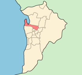 |
||
| Prospect Prospect, South Australia Prospect is a suburb located to the north of the centre of Adelaide, the capital city of South Australia.Surrounding suburbs include Kilburn, Fitzroy, and Medindie. Prospect is a middle to upper class suburb of Adelaide... |
Metropolitan Adelaide Adelaide Adelaide is the capital city of South Australia and the fifth-largest city in Australia. Adelaide has an estimated population of more than 1.2 million... |
||||||
| Salisbury Salisbury, South Australia Salisbury is a northern suburb in Adelaide, South Australia. It is the seat of the City of Salisbury, and in the South Australian Legislative Assembly electoral district of Ramsay and the Australian House of Representatives divisions of Wakefield and Port Adelaide... |
Metropolitan Adelaide Adelaide Adelaide is the capital city of South Australia and the fifth-largest city in Australia. Adelaide has an estimated population of more than 1.2 million... |
||||||
| Modbury Modbury, South Australia Modbury is a suburb of Adelaide, South Australia in the City of Tea Tree Gully. Modbury is located at the end of the Adelaide O-Bahn and is home to the Tea Tree Plaza shopping complex and a Hospital.It was named Modbury by R... |
Metropolitan Adelaide Adelaide Adelaide is the capital city of South Australia and the fifth-largest city in Australia. Adelaide has an estimated population of more than 1.2 million... |
Originally part of Highercombe District Council. Became a separate district council in 1858. Reunited with Highercombe in 1935 under current name. | |||||
| Unley Unley, South Australia Unley is an inner-southern suburb of Adelaide, South Australia. The relatively wealthy area lies within the City of Unley. The suburb is the home of the Sturt Football Club, an SANFL team... |
Metropolitan Adelaide Adelaide Adelaide is the capital city of South Australia and the fifth-largest city in Australia. Adelaide has an estimated population of more than 1.2 million... |
||||||
| Gilberton Gilberton, South Australia Gilberton is a suburb of Adelaide, South Australia on the northern bank of the River Torrens a short distance from Adelaide’s city centre. It is bounded by the river, Park terrace, Stephen Terrace and Northcote Terrace. The suburb is largely residential with some large and ornate Victorian homes... |
Metropolitan Adelaide Adelaide Adelaide is the capital city of South Australia and the fifth-largest city in Australia. Adelaide has an estimated population of more than 1.2 million... |
||||||
| Hilton Hilton, South Australia Hilton is an inner western suburb of Adelaide, South Australia. It is located in the City of West Torrens, for which it is the council seat.-History:The land now covering the suburb of Hilton was received by Matthew Davenport Hill in 1839... |
Metropolitan Adelaide Adelaide Adelaide is the capital city of South Australia and the fifth-largest city in Australia. Adelaide has an estimated population of more than 1.2 million... |
||||||
| Ceduna Ceduna, South Australia Ceduna is a small town in the West Coast region of South Australia. It is situated in the northwest corner of Eyre Peninsula, facing the islands of the Nuyts Archipelago. It lies west of the junction of the Flinders and Eyre Highways around 786 km northwest of the capital Adelaide. The port... |
Eyre Peninsula | 1896 | |||||
| Cleve Cleve, South Australia Cleve is a small agriculturally based town on Central Eyre Peninsula in South Australia. It is 226 km southwest of Port Augusta and 143 km north of Port Lincoln... |
Eyre Peninsula | 1911 | Separated from Franklin Harbour District Council of Franklin Harbour The District Council of Franklin Harbour is a Local Government Area in South Australia located on the Eyre Peninsula. Cowell is the major population centre of an agricultural district based on farming wheat and sheep, supplemented by a fishing and oyster farming industries... |
||||
| Elliston Elliston, South Australia Elliston is a small coastal town in South Australia on the west coast of Eyre Peninsula 169 km northwest of Port Lincoln and 641 km west of Adelaide. The township is located on Waterloo Bay.... |
Eyre Peninsula | 1887 | 6,500 | Boundary changes in 1989 | |||
| Cowell Cowell, South Australia Cowell is a coastal town on Franklin Harbour on the eastern side of the Eyre Peninsula, in South Australia on the Lincoln Highway 111 km south from the major town of Whyalla... |
Eyre Peninsula | 1888 | 3,283 | ||||
| Kimba Kimba, South Australia Kimba is a rural service town on the Eyre Highway at the top of Eyre Peninsula in South Australia. At the 2006 census, Kimba had a population of 636 and it has an annual rainfall of 339 mm. There is 7 metre tall statue of a big galah beside the highway marking halfway between the east and west... |
Eyre Peninsula | 1924 | |||||
| Cummins Cummins, South Australia Cummins is a town on Eyre Peninsula in South Australia, 67 km north of Port Lincoln and 68 m above sea level. At the 2006 census, the town had a population of 705.... |
Eyre Peninsula | 1921 | 4,771 | Part of District Council of Port Lincoln (proclaimed 1880). District Council of Tumby Bay District Council of Tumby Bay The Tumby Bay District Council is a local government area of South Australia covering an area of the North Eastern Eyre Peninsula. Established in 1906, only six years after the town of Tumby Bay was established, the district was annexed from the former District Council of Port Lincoln to form the... separated in 1906. Corporation of Port Lincoln City of Port Lincoln The City of Port Lincoln is a local government area located on the southern tip of the Eyre Peninsula in South Australia. It consists only of the city of Port Lincoln and its suburbs... separated in 1921. Remainder named District Council of Lincoln. Renamed Lower Eyre Peninsula in 1988. |
|||
| Port Augusta Port Augusta, South Australia -Electricity generation:Electricity is generated at the Playford B and Northern power stations from brown coal mined at Leigh Creek, 250 km to the north... |
Eyre Peninsula | 1964 | |||||
| Port Lincoln Port Lincoln, South Australia - Transport :Port Lincoln is the port for the isolated narrow gauge Eyre Peninsular Railway.There is also a subsidiary port at Proper Bay which may be restored to use for iron ore traffic. The export of iron ore through Port Lincoln has been approved by the South Australian Government. Port... |
Eyre Peninsula | 1921 | Separated from District Council of Port Lincoln District Council of Lower Eyre Peninsula The District Council of Lower Eyre Peninsula is a local government area located on Eyre Peninsula in South Australia. The district covers the southern tip of the peninsula, except for the small area taken up by the City of Port Lincoln.... in 1921. Proclaimed a city in 1971 |
||||
| Streaky Bay Streaky Bay, South Australia Streaky Bay is a coastal town on the western side of the Eyre Peninsula, in South Australia just off the Flinders Highway 303 km north west of Port Lincoln and 727 km by road from Adelaide... |
Eyre Peninsula | 1887 | 6,232 | ||||
| Tumby Bay Tumby Bay, South Australia Tumby Bay is a coastal town situated on the Spencer Gulf, on the eastern coast of Eyre Peninsula in South Australia, 45 km north of Port Lincoln... |
Eyre Peninsula | 1906 | Separated from District Council of Port Lincoln District Council of Lower Eyre Peninsula The District Council of Lower Eyre Peninsula is a local government area located on Eyre Peninsula in South Australia. The district covers the southern tip of the peninsula, except for the small area taken up by the City of Port Lincoln.... |
||||
| Wudinna Wudinna, South Australia Wudinna is a town in South Australia. The area was first settled in 1861 when Robert George Standley lodged a claim for 10 sq. miles of land surrounding Weedna Hill .. It was proclaimed a town in 1916... |
Eyre Peninsula | 1925 | Established as the District Council of Minnipa. Later renamed as District Council of Le Hunte. Given present name in 2008. | ||||
| Whyalla Whyalla, South Australia -Demographics:According to the 2006 Census the population of the Whyalla census area was 21,122 people, making it the second largest urban area in the state outside of Adelaide... |
Eyre Peninsula | 1970 | |||||
| Angaston Angaston, South Australia Angaston is a town in the Barossa Valley, South Australia, 77 km north east of Adelaide. Its elevation is 347 m, one of the highest points in the valley, and has an average rainfall of 561 mm... |
Central | 1996 | 912 | Amalgamation of District Councils of Angaston, Barossa, Tanunda and (since 1997) part of Mount Pleasant | |||
| Port Broughton Port Broughton, South Australia Port Broughton is a small South Australian town located on the Yorke Peninsula on the east coast of Spencer Gulf. It is situated about 170 km north west of Adelaide, and 56 km south of Port Pirie At the 2006 census, Port Broughton had a population of 908.... |
Central | ||||||
| Clare Clare, South Australia The town of Clare is located in South Australia in the Mid North region, 136 km north of Adelaide. It gives its name to the Clare Valley wine and tourist region.-History:One of the first settlers in the area was John Horrocks, in 1839... |
Central | 1997 | Amalgamation of District Council of Clare, the District Council of Riverton and the District Council of Saddleworth and Auburn. | ||||
| Kadina Kadina, South Australia Kadina is a town located on the Yorke Peninsula of South Australia, approximately 144 kilometres north-northwest of the state capital of Adelaide. The largest town of the Peninsula, Kadina is one of the three Copper Triangle towns famous for their shared copper mining history... |
Central | 1997 | 773 | Amalgamation of District Council of Northern Yorke Peninsula and Corporation of the Town of Wallaroo | |||
| Quorn Quorn, South Australia Quorn is a township and railhead in the Flinders Ranges in the north of South Australia, 39 km northeast of Port Augusta. At the 2006 census, Quorn had a population of 1068.Quorn is the home of the Flinders Ranges Council local government area... |
Central | 4,198 | |||||
| Burra Burra, South Australia Burra is a pastoral centre and historic tourist town in the mid-north of South Australia. It lies east of the Clare Valley in the Bald Hills range, part of the northern Mount Lofty Ranges, and on Burra Creek. The town began as a single company mining township that, by 1851, was a set of townships ... |
Central | 1997 | Amalgamation of District Councils of Burra Burra (formerly the Corporation of the Town of Burra and the Burra District Council), Eudunda, Hallet and Robertstown. | ||||
| Kapunda | Central | ||||||
| Central | |||||||
| Melrose Melrose, South Australia Melrose is the oldest town in the Flinders Ranges. It is in the shadow of Mount Remarkable, 265 km north of Adelaide. At the 2006 census, Melrose had a population of 431.... |
Central | 1980 | Amalgamation of Port Germein District Council and Wilmington District Council | ||||
| Central | 1997 | Amalgamation of District Councils of Rocky River, Spalding, and Jamestown | |||||
| Central | |||||||
| Peterborough Peterborough, South Australia Peterborough is a town in the mid north of South Australia, in wheat country, just off the Barrier Highway. At the 2006 census, Peterborough had a population of 1,689.... |
Central | ||||||
| Port Pirie Port Pirie, South Australia -Transport:Port Pirie is located off National Highway One. It is serviced by an airport five minutes out of the city.- Railways :The first railways in Port Pirie were of the narrow [3' 6"] gauge.... |
Central | ||||||
| Balaklava Balaklava, South Australia The town of Balaklava is located in South Australia, 92 kilometres north of Adelaide in the Mid North region. It is on the banks of the Wakefield River, 25 kilometres east of Port Wakefield.-History:... |
Central | 1997 | Amalgamation of District Councils of Blyth-Snowtown and Wakefield Plains. | ||||
| Maitland Maitland, South Australia Maitland is a town in South Australia located 168 km west of Adelaide by road, 164 km south of Port Pirie and 46 km north of Minlaton known as the "heart of Yorke Peninsula" due to being near the center of the region... |
Central | 1997 | 5,834 | ||||
| Goolwa Goolwa, South Australia Goolwa is a historic river port on the Murray River near the Murray Mouth in South Australia, and joined by a bridge to Hindmarsh Island. The name "Goolwa" means "elbow" in Ngarrindjeri, the local Aboriginal language.... |
Southern and Hills | 1997 | Amalgamation of the District Council of Strathalbyn, the District Council of Port Elliot and Goolwa, and a portion of the District Council of Willunga. | ||||
| Kingscote Kingscote, South Australia - Facilities :Kingscote has a school offering years 1 to 12, a hospital, supermarket, post office and Government offices. It is the administrative centre for the Kangaroo Island Council, whose offices have recently undergone a significant upgrade.... |
Southern and Hills | 1996 | Amalgamation of the District Council of Kingscote and the District Council of Dudley. | ||||
| Mount Barker Mount Barker, South Australia Mount Barker is an expanding city, home to 10 258 residents that is 33 kilometres up the South Eastern Freeway, east of Adelaide, in South Australia. It is the seat of the District Council of Mount Barker, is the largest town in the Adelaide Hills, and is one of the fastest growing areas in the... |
Southern and Hills | ||||||
| Victor Harbor Victor Harbor, South Australia Victor Harbor is a city located on the coast of the Fleurieu Peninsula, about 80 km south of Adelaide, South Australia. The city is the largest population centre on the peninsula, with an economy based upon agriculture, fisheries and various industries... |
Southern and Hills | 1975 | Amalgamation of District Council of Encounter Bay and the Corporation of Victor Harbor in 1975. Formerly a district council, became a city in 2000. | ||||
| Yankalilla Yankalilla, South Australia Yankalilla is an agriculturally-based town situated on the southern Fleurieu Peninsula in South Australia, located 72 km south of the state's capital of Adelaide... |
Southern and Hills | 1854 | |||||
| Murray Mallee | 1996 | 508 | Amalgamation of district councils of Barmera and Berri. | ||||
| Meningie Meningie, South Australia Meningie is a town on the southeast side of Lake Albert in South Australia. It is on the Princes Highway near The Coorong and was surveyed in 1866. At the 2006 census, Meningie had a population of 940.... |
Murray Mallee | 1995 | Amalgamation of District Council of Coonalpyn Downs, Peake District Council and Meningie District Council. | 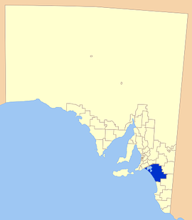 |
|||
| Winkie Winkie, South Australia Winkie is a settlement in South Australia, around 11 km southwest of the Riverland town of Berri, and around the same distance southeast of Barmera. It is close to the Murray River, which passes through Berri. At the 2006 census, Winkie had a population of 706.... |
Murray Mallee | 1974 | |||||
| Karoonda Karoonda, South Australia Karoonda is in the middle of the Murray Mallee region of South Australia at geographic coordinates . Karoonda takes its name from the Aboriginal word for "winter camp".... |
Murray Mallee | 1979 | 4,415 | Amalgamation of District Council of Karoonda and District Council of East Murray | |||
| Murray Mallee | 1997 | 7,957 | Amalgamation of district councils of Loxton, Waikerie and Browns Well. | ||||
| Murray Mallee | 1997 | 7,957 | Amalgamation of district councils of Mannum, Morgan, Ridley-Truro and part of the District Council of Mount Pleasant. | ||||
| Murray Bridge Murray Bridge, South Australia Murray Bridge is the fourth most populous city in South Australia after Adelaide, Mount Gambier and Whyalla. It is located east-southeast of Adelaide and north of Meningie.... |
Murray Mallee | ||||||
| Renmark Renmark, South Australia Renmark is a town in South Australia's rural Riverland area, and is located 254 km northeast of Adelaide, on the banks of the River Murray. The Sturt Highway between Adelaide and Sydney runs through the town; Renmark is the last major town encountered in South Australia when driving this route. It... |
Murray Mallee | 1996 | Amalgamation of Town of Renmark and the District Council of Paringa. | ||||
| Pinnaroo Pinnaroo, South Australia Pinnaroo is a town in the Murray Mallee region of South Australia, near the border with Victoria 243 km east of Adelaide. Pinnaroo is on the Mallee Highway, and the railway line between Tailem Bend and Ouyen. The roadhouses on the highway are the first food and leg-stretch stop on the bus route... |
Murray Mallee | 6,000 | |||||
| Mount Gambier Mount Gambier, South Australia Mount Gambier is the largest regional city in South Australia located approximately 450 kilometres south of the capital Adelaide and just 17 kilometres from the Victorian border.... |
Southeast | 1996 | 1,904 | Amalgamation of District Councils of Mount Gambier and Port MacDonnell. | |||
| Kingston SE Kingston SE, South Australia Kingston SE is a town approximately 297 km southeast of Adelaide, the capital of South Australia, and 44 km from the town of Robe. It is at the southeastern end of Encounter Bay and the Coorong. At the 2006 census, Kingston SE had a population of 1,443.-History:The town was named after... |
Southeast | 1873 | Renamed from Lacepede District Council in 2000. | ||||
| Mount Gambier Mount Gambier, South Australia Mount Gambier is the largest regional city in South Australia located approximately 450 kilometres south of the capital Adelaide and just 17 kilometres from the Victorian border.... |
Southeast | 308 | |||||
| Naracoorte Naracoorte, South Australia Naracoorte is a town in the Limestone Coast region of South Australia, approximately 336 kilometres south east of Adelaide and 100 kilometres north of Mount Gambier on the Riddoch Highway .-History:... |
Southeast | 1993 | Amalgamation of District Council of Naracoorte, District Council of Lucindale and the Corporate Township of Naracoorte. | ||||
| Robe Robe, South Australia Robe is a town and fishing port on the South East Limestone Coast of South Australia. The town's distinctive combination of historical buildings, ocean, fishing fleets, lakes and dense bush is widely appreciated. Robe lies on the southern shore of Guichen Bay, just off the Princes Highway. At the... |
Southeast | 1869 | |||||
| Bordertown Bordertown, South Australia Bordertown is a small South Australian town near the Victorian border. It is where the Dukes Highway and the railway line, the two main routes between Adelaide and Melbourne, cross Tatiara Creek.... |
Southeast | 1876 | 6,476 | ||||
| Millicent Millicent, South Australia Millicent is a town in South Australia, south-east of Adelaide, and north of Mount Gambier. At the 2006 Census, the population was 4,771.The town is home to the Millicent National Trust Museum, and is nearby to the Tantanoola Caves Conservation Park and the Canunda National Park.The Millicent... |
Southeast | 1997 | Amalgamation of district councils of Beachport, Millicent and Penola. | ||||
| Umuwa | Outback | 1981 | 102,650 | 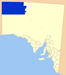 |
|||
| Coober Pedy Coober Pedy, South Australia Coober Pedy is a town in northern South Australia, 846 kilometres north of Adelaide on the Stuart Highway. According to the 2006 census, its population was 1,916 . The town is sometimes referred to as the "opal capital of the world" because of the quantity of precious opals that are mined there... |
Outback | 1987 | |||||
| Ceduna Ceduna, South Australia Ceduna is a small town in the West Coast region of South Australia. It is situated in the northwest corner of Eyre Peninsula, facing the islands of the Nuyts Archipelago. It lies west of the junction of the Flinders and Eyre Highways around 786 km northwest of the capital Adelaide. The port... |
Outback | 2006 | 102,863 | ||||
| Nepabunna | Outback | 1998 | |||||
| Port Augusta Port Augusta, South Australia -Electricity generation:Electricity is generated at the Playford B and Northern power stations from brown coal mined at Leigh Creek, 250 km to the north... |
Outback | 1978 | 624,339 | Covers almost 60 percent of the state's area, mostly in the arid regions of the centre and north. | |||
| Roxby Downs | Outback | 1982 | 110 | ||||
| Outback | 1994 | 4,563 |