
Little Current Swing Bridge
Encyclopedia
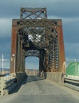
The Little Current Swing Bridge is a swing bridge
in the Canadian
province of Ontario
, located at the community of Little Current in the town of Northeastern Manitoulin and the Islands
.
The bridge carries Highway 6
(formerly Highway 68
) across a narrow channel
separating Manitoulin Island
from the much smaller Goat Island
, forming the only land access. It consists of two 21 m (70 ft) deck plate girder approaches on the north end (Goat Island) and a single 18 m (60 ft) deck plate girder approach on the south end (Manitoulin Island), with a 112 m (368 ft) through swing bridge span. The swing bridge sits 5.3 m (17.5 ft) above mean water level, and provides a 48 m (160 ft) opening on either side of the central pier for water passage.
Construction on the bridge foundations was commenced in 1912 by the Algoma Eastern Railway, and the bridge itself was constructed in 1913. Originally a railway-only bridge, the bridge stayed in the open position at all times except when a train needed to pass. Passenger traffic to the island was available only by ferry
until 1946, when the bridge was improved to allow both rail and vehicle traffic. Train service to the island was subsequently truncated in the 1980s, with railway service ending at Turner on the Goat Island side, and the bridge now serves only vehicle traffic.
The bridge now strongly favours highway traffic, staying in the closed (motor vehicles can pass) position at all times, except for the first fifteen minutes of each daylight hour during the summer, when it opens to permit boating traffic. At night and when the shipping channel is closed during the winter, the bridge stays in the closed position at all times. Originally powered by a gasoline engine, the mechanism was upgraded to electric motors in 2003. Due to the single vehicle lane, it is equipped with traffic signals, the only installation of such on Manitoulin Island. From mid-October to early May when the ferry MS Chi-Cheemaun is not in operation to carry passengers from the Bruce Peninsula
, the bridge is the only road link to Manitoulin Island.
The bridge has been designated an Ontario Heritage site.
Swing bridge
A swing bridge is a movable bridge that has as its primary structural support a vertical locating pin and support ring, usually at or near to its centre of gravity, about which the turning span can then pivot horizontally as shown in the animated illustration to the right...
in the Canadian
Canada
Canada is a North American country consisting of ten provinces and three territories. Located in the northern part of the continent, it extends from the Atlantic Ocean in the east to the Pacific Ocean in the west, and northward into the Arctic Ocean...
province of Ontario
Ontario
Ontario is a province of Canada, located in east-central Canada. It is Canada's most populous province and second largest in total area. It is home to the nation's most populous city, Toronto, and the nation's capital, Ottawa....
, located at the community of Little Current in the town of Northeastern Manitoulin and the Islands
Northeastern Manitoulin and the Islands, Ontario
Northeastern Manitoulin and the Islands is a municipality with "town" status in Manitoulin District in Northeastern Ontario, Canada, approximately 30 kilometres south of Espanola. Its main town is Little Current, located on the northeast side of Manitoulin Island...
.
The bridge carries Highway 6
Highway 6 (Ontario)
King's Highway 6, also known as Highway 6, is a provincially maintained highway in the Canadian province of Ontario. It crosses a distance of between Port Dover on the north shore of Lake Erie and Espanola on the northern shore of Lake Huron, ending at the Trans-Canada Highway in McKerrow.- Port...
(formerly Highway 68
Highway 68 (Ontario)
Highway 68 was a provincially maintained highway on Manitoulin Island, linking the island to the mainland. It was connected to the rest of the network by Highway 17 in McKerrow...
) across a narrow channel
Channel (geography)
In physical geography, a channel is the physical confine of a river, slough or ocean strait consisting of a bed and banks.A channel is also the natural or human-made deeper course through a reef, sand bar, bay, or any shallow body of water...
separating Manitoulin Island
Manitoulin Island
Manitoulin Island is a Canadian island in Lake Huron, in the province of Ontario. It is the largest island in a freshwater lake in the world. In addition to the historic Anishinaabe and European settlement of the island, archeological discoveries at Sheguiandah have demonstrated Paleo-Indian and...
from the much smaller Goat Island
Goat Island (Ontario)
Goat Island is a small island in the Canadian province of Ontario, located in the town of Northeastern Manitoulin and the Islands in the Manitoulin District....
, forming the only land access. It consists of two 21 m (70 ft) deck plate girder approaches on the north end (Goat Island) and a single 18 m (60 ft) deck plate girder approach on the south end (Manitoulin Island), with a 112 m (368 ft) through swing bridge span. The swing bridge sits 5.3 m (17.5 ft) above mean water level, and provides a 48 m (160 ft) opening on either side of the central pier for water passage.
Construction on the bridge foundations was commenced in 1912 by the Algoma Eastern Railway, and the bridge itself was constructed in 1913. Originally a railway-only bridge, the bridge stayed in the open position at all times except when a train needed to pass. Passenger traffic to the island was available only by ferry
Ferry
A ferry is a form of transportation, usually a boat, but sometimes a ship, used to carry primarily passengers, and sometimes vehicles and cargo as well, across a body of water. Most ferries operate on regular, frequent, return services...
until 1946, when the bridge was improved to allow both rail and vehicle traffic. Train service to the island was subsequently truncated in the 1980s, with railway service ending at Turner on the Goat Island side, and the bridge now serves only vehicle traffic.
The bridge now strongly favours highway traffic, staying in the closed (motor vehicles can pass) position at all times, except for the first fifteen minutes of each daylight hour during the summer, when it opens to permit boating traffic. At night and when the shipping channel is closed during the winter, the bridge stays in the closed position at all times. Originally powered by a gasoline engine, the mechanism was upgraded to electric motors in 2003. Due to the single vehicle lane, it is equipped with traffic signals, the only installation of such on Manitoulin Island. From mid-October to early May when the ferry MS Chi-Cheemaun is not in operation to carry passengers from the Bruce Peninsula
Bruce Peninsula
The Bruce Peninsula is a peninsula in Ontario, Canada that lies between Georgian Bay and the main basin of Lake Huron. The peninsula extends roughly northwestwards from the rest of Southern Ontario, pointing towards Manitoulin Island, with which it forms the widest strait joining Georgian Bay to...
, the bridge is the only road link to Manitoulin Island.
The bridge has been designated an Ontario Heritage site.