

List of submarine topographical features
Encyclopedia
Abyssal plain
An abyssal plain is an underwater plain on the deep ocean floor, usually found at depths between 3000 and 6000 metres. Lying generally between the foot of a continental rise and a mid-ocean ridge, abyssal plains cover more than 50% of the Earth’s surface. They are among the flattest, smoothest...
is an underwater plain on the deep ocean floor, usually found at depths between 3000 metres (9,842.5 ft) and 6000 metres (19,685 ft). Lying generally between the foot of a continental rise and a mid-ocean ridge
Mid-ocean ridge
A mid-ocean ridge is a general term for an underwater mountain system that consists of various mountain ranges , typically having a valley known as a rift running along its spine, formed by plate tectonics. This type of oceanic ridge is characteristic of what is known as an oceanic spreading...
, abyssal plains are among the flattest, smoothest and least explored regions on Earth. Abyssal plains are key geologic elements of oceanic basin
Oceanic basin
Hydrologically, an oceanic basin may be anywhere on Earth that is covered by seawater, but geologically ocean basins are large geologic basins that are below sea level...
s (the other elements being an elevated mid-ocean ridge and flanking abyssal hill
Abyssal hill
An abyssal hill is a small hill that rises from the floor ofan abyssal plain. They are the most abundant geomorphic structures on the planet Earth, covering more than 30% of the ocean floors. Abyssal hills have relatively sharply defined edges and climb to heights of no more than a few hundred...
s). In addition to these elements, active oceanic basins (those that are associated with a moving plate tectonic
Plate tectonics
Plate tectonics is a scientific theory that describes the large scale motions of Earth's lithosphere...
boundary) also typically include an oceanic trench
Oceanic trench
The oceanic trenches are hemispheric-scale long but narrow topographic depressions of the sea floor. They are also the deepest parts of the ocean floor....
and a subduction zone
Subduction
In geology, subduction is the process that takes place at convergent boundaries by which one tectonic plate moves under another tectonic plate, sinking into the Earth's mantle, as the plates converge. These 3D regions of mantle downwellings are known as "Subduction Zones"...
. Though they cover more than 50% of the Earth’s surface, they are poorly preserved in the sedimentary record
Geologic record
The geologic record in stratigraphy, paleontology and other natural sciences refers to the entirety of the layers of rock strata — deposits laid down in volcanism or by sediment deposition of weathering detritus including all its fossil content and the information it yields about the history...
because they tend to be consumed by the subduction process. The abyssal plain is formed when the lower oceanic crust
Oceanic crust
Oceanic crust is the part of Earth's lithosphere that surfaces in the ocean basins. Oceanic crust is primarily composed of mafic rocks, or sima, which is rich in iron and magnesium...
is melted and forced upwards by the asthenosphere
Asthenosphere
The asthenosphere is the highly viscous, mechanically weak and ductilely-deforming region of the upper mantle of the Earth...
layer of the upper mantle
Mantle (geology)
The mantle is a part of a terrestrial planet or other rocky body large enough to have differentiation by density. The interior of the Earth, similar to the other terrestrial planets, is chemically divided into layers. The mantle is a highly viscous layer between the crust and the outer core....
. As this basalt
Basalt
Basalt is a common extrusive volcanic rock. It is usually grey to black and fine-grained due to rapid cooling of lava at the surface of a planet. It may be porphyritic containing larger crystals in a fine matrix, or vesicular, or frothy scoria. Unweathered basalt is black or grey...
ic material reaches the surface at mid-ocean ridges, it forms new oceanic crust. Abyssal plains result from the blanketing of an originally uneven surface of oceanic crust by fine-grained sediment
Sediment
Sediment is naturally occurring material that is broken down by processes of weathering and erosion, and is subsequently transported by the action of fluids such as wind, water, or ice, and/or by the force of gravity acting on the particle itself....
s, mainly clay
Clay
Clay is a general term including many combinations of one or more clay minerals with traces of metal oxides and organic matter. Geologic clay deposits are mostly composed of phyllosilicate minerals containing variable amounts of water trapped in the mineral structure.- Formation :Clay minerals...
and silt
Silt
Silt is granular material of a size somewhere between sand and clay whose mineral origin is quartz and feldspar. Silt may occur as a soil or as suspended sediment in a surface water body...
. Much of this sediment is deposited from turbidity current
Turbidity current
A turbidity current is a current of rapidly moving, sediment-laden water moving down a slope through water, or another fluid. The current moves because it has a higher density and turbidity than the fluid through which it flows...
s that have been channeled from the continental margin
Continental margin
The continental margin is the zone of the ocean floor that separates the thin oceanic crust from thick continental crust. Continental margins constitute about 28% of the oceanic area....
s along submarine canyon
Submarine canyon
A submarine canyon is a steep-sided valley on the sea floor of the continental slope. Many submarine canyons are found as extensions to large rivers; however there are some that have no such association. Canyons cutting the continental slopes have been found at depths greater than 2 km below sea...
s down into deeper water. The remainder of the sediment is composed chiefly of pelagic sediments
Pelagic sediments
Pelagic sediment or pelagite is a fine-grained sediment that has accumulated by the settling of particles through the water column to the ocean floor beneath the open ocean far from land. These particles consist primarily of either the microscopic, calcareous or siliceous shells of phytoplankton or...
. Use of a continuously recording fathometer
Fishfinder
A fishfinder is an instrument used to locate fish underwater by detecting reflected pulses of sound energy, as in SONAR. A modern fishfinder displays measurements of reflected sound on a graphical display, allowing an operator to interpret information to locate schools of fish, underwater debris,...
enabled Tolstoy & Ewing in the summer of 1947 to identify and describe the first abyssal plain. This plain, located to the south of Newfoundland
Newfoundland and Labrador
Newfoundland and Labrador is the easternmost province of Canada. Situated in the country's Atlantic region, it incorporates the island of Newfoundland and mainland Labrador with a combined area of . As of April 2011, the province's estimated population is 508,400...
, is now known as the Sohm Abyssal Plain
Sohm Abyssal Plain
The Sohm Abyssal Plain is in the North Atlantic and has an area of around ....
. Following this discovery many other examples were found in all the oceans.
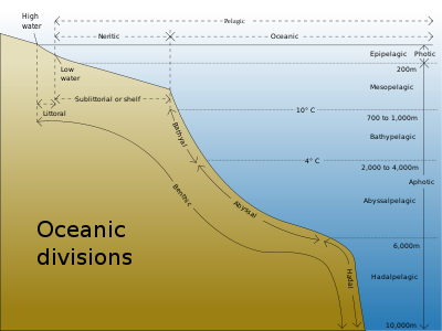
Oceanic trenches are long, narrow topographic
Topography
Topography is the study of Earth's surface shape and features or those ofplanets, moons, and asteroids...
depressions of the seabed
Seabed
The seabed is the bottom of the ocean.- Ocean structure :Most of the oceans have a common structure, created by common physical phenomena, mainly from tectonic movement, and sediment from various sources...
. The deepest parts of the ocean floor, they define one of the most important natural boundaries on the Earth's solid surface: the one between two lithospheric
Lithosphere
The lithosphere is the rigid outermost shell of a rocky planet. On Earth, it comprises the crust and the portion of the upper mantle that behaves elastically on time scales of thousands of years or greater.- Earth's lithosphere :...
plates. Trenches are a distinctive morphological feature of plate boundaries. There are three types of lithospheric plate boundaries: divergent
Divergent boundary
In plate tectonics, a divergent boundary or divergent plate boundary is a linear feature that exists between two tectonic plates that are moving away from each other. Divergent boundaries within continents initially produce rifts which produce rift valleys...
(where lithosphere and oceanic crust is created at mid-ocean ridges), convergent
Convergent boundary
In plate tectonics, a convergent boundary, also known as a destructive plate boundary , is an actively deforming region where two tectonic plates or fragments of lithosphere move toward one another and collide...
(where one lithospheric plate sinks beneath another and returns to the mantle), and transform
Transform fault
A transform fault or transform boundary, also known as conservative plate boundary since these faults neither create nor destroy lithosphere, is a type of fault whose relative motion is predominantly horizontal in either sinistral or dextral direction. Furthermore, transform faults end abruptly...
(where two lithospheric plates slide past each other). An oceanic trench is a type of convergent boundary at which two oceanic lithospheric slabs meet; the older (and therefore denser) of these slabs flexes and subducts beneath the other slab. Oceanic lithosphere moves into trenches at a global rate of about a tenth of a square meter per second. Trenches are generally parallel to a volcanic
High island
In geology , a high island is an island of volcanic origin. The term can be used to distinguish such islands from low islands, whose origin is due to sedimentation or uplifting of coral reefs.-Definition and origin:...
island arc
Island arc
An island arc is a type of archipelago composed of a chain of volcanoes which alignment is arc-shaped, and which are situated parallel and close to a boundary between two converging tectonic plates....
, and about 200 km from a volcanic arc
Volcanic arc
A volcanic arc is a chain of volcanoes positioned in an arc shape as seen from above. Offshore volcanoes form islands, resulting in a volcanic island arc. Generally they result from the subduction of an oceanic tectonic plate under another tectonic plate, and often parallel an oceanic trench...
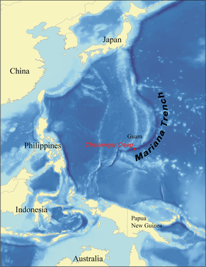
. Oceanic trenches typically extend 3 to 4 km (1.9 to 2.5 mi) below the level of the surrounding oceanic floor. The greatest ocean depth to be sounded is in the Challenger Deep
Challenger Deep
The Challenger Deep is the deepest known point in the oceans, with a depth of to by direct measurement from submersibles, and slightly more by sonar bathymetry . It is located at the southern end of the Mariana Trench near the Mariana Islands group...
of the Mariana Trench
Mariana Trench
The Mariana Trench or Marianas Trench is the deepest part of the world's oceans. It is located in the western Pacific Ocean, to the east of the Mariana Islands. The trench is about long but has a mean width of only...
, at a depth of 10,911 m (35,798 ft) below sea level.
An oceanic plateau
Oceanic plateau
An oceanic plateau is a large, relatively flat submarine region that rises well above the level of the ambient seabed. While many oceanic plateaus are composed of continental crust, and often form a step interrupting the continental slope, some plateaus are undersea remnants of large igneous...
is a large, relatively flat submarine region that rises well above the level of the ambient seabed. While many oceanic plateaus are composed of continental crust
Continental crust
The continental crust is the layer of igneous, sedimentary, and metamorphic rocks which form the continents and the areas of shallow seabed close to their shores, known as continental shelves. This layer is sometimes called sial due to more felsic, or granitic, bulk composition, which lies in...
, and often form a step interrupting the continental slope
Continental margin
The continental margin is the zone of the ocean floor that separates the thin oceanic crust from thick continental crust. Continental margins constitute about 28% of the oceanic area....
, some plateaus are undersea remnants of large igneous province
Large igneous province
A Large Igneous Province is an extremely large accumulation of igneous rocks—intrusive, extrusive, or both—in the earth's crust...
s. Continental crust has the highest amount of silicon
Silicon
Silicon is a chemical element with the symbol Si and atomic number 14. A tetravalent metalloid, it is less reactive than its chemical analog carbon, the nonmetal directly above it in the periodic table, but more reactive than germanium, the metalloid directly below it in the table...
(such rock is called felsic
Felsic
The word "felsic" is a term used in geology to refer to silicate minerals, magma, and rocks which are enriched in the lighter elements such as silicon, oxygen, aluminium, sodium, and potassium....
). Oceanic crust has a smaller amount of silicon (mafic
Mafic
Mafic is an adjective describing a silicate mineral or rock that is rich in magnesium and iron; the term is a portmanteau of the words "magnesium" and "ferric". Most mafic minerals are dark in color and the relative density is greater than 3. Common rock-forming mafic minerals include olivine,...
rock). The anomalous volcanism
Volcanism
Volcanism is the phenomenon connected with volcanoes and volcanic activity. It includes all phenomena resulting from and causing magma within the crust or mantle of a planet to rise through the crust and form volcanic rocks on the surface....
associated with the formation of oceanic plateaux at the time of the Cenomanian
Cenomanian
The Cenomanian is, in the ICS' geological timescale the oldest or earliest age of the Late Cretaceous epoch or the lowest stage of the Upper Cretaceous series. An age is a unit of geochronology: it is a unit of time; the stage is a unit in the stratigraphic column deposited during the corresponding...
-Turonian
Turonian
The Turonian is, in the ICS' geologic timescale, the second age in the Late Cretaceous epoch, or a stage in the Upper Cretaceous series. It spans the time between 93.5 ± 0.8 Ma and 89.3 ± 1 Ma...
boundary (90.4 million years) ago may have been responsible for the environmental disturbances that occurred at that time. The physical manifestations of this were elevated atmospheric and oceanic temperatures, a significant sea-level transgression, and a period of widespread anoxia
Anoxic event
Oceanic anoxic events or anoxic events occur when the Earth's oceans become completely depleted of oxygen below the surface levels. Although anoxic events have not happened for millions of years, the geological record shows that they happened many times in the past. Anoxic events may have caused...
, leading to the extinction of 26% of all genera
Genus
In biology, a genus is a low-level taxonomic rank used in the biological classification of living and fossil organisms, which is an example of definition by genus and differentia...
. These eruptions would also have resulted in the emission of large quantities of carbon dioxide
Carbon dioxide
Carbon dioxide is a naturally occurring chemical compound composed of two oxygen atoms covalently bonded to a single carbon atom...
into the atmosphere, leading to global warming
Global warming
Global warming refers to the rising average temperature of Earth's atmosphere and oceans and its projected continuation. In the last 100 years, Earth's average surface temperature increased by about with about two thirds of the increase occurring over just the last three decades...
. Additionally, the emission of sulfur monoxide
Sulfur monoxide
Sulfur monoxide is an inorganic compound with formula . It is only found as a dilute gas phase. When concentrated or condensed, it converts to S2O2 . It has been detected in space but is rarely encountered intact otherwise.-Structure and bonding:The SO molecule has a triplet ground state similar...
, hydrogen sulfide
Hydrogen sulfide
Hydrogen sulfide is the chemical compound with the formula . It is a colorless, very poisonous, flammable gas with the characteristic foul odor of expired eggs perceptible at concentrations as low as 0.00047 parts per million...
, carbon monoxide
Carbon monoxide
Carbon monoxide , also called carbonous oxide, is a colorless, odorless, and tasteless gas that is slightly lighter than air. It is highly toxic to humans and animals in higher quantities, although it is also produced in normal animal metabolism in low quantities, and is thought to have some normal...
, and halogen
Halogen
The halogens or halogen elements are a series of nonmetal elements from Group 17 IUPAC Style of the periodic table, comprising fluorine , chlorine , bromine , iodine , and astatine...
s into the oceans would have made seawater more acid
Acid
An acid is a substance which reacts with a base. Commonly, acids can be identified as tasting sour, reacting with metals such as calcium, and bases like sodium carbonate. Aqueous acids have a pH of less than 7, where an acid of lower pH is typically stronger, and turn blue litmus paper red...
ic resulting in the dissolution of carbonate
Carbonate
In chemistry, a carbonate is a salt of carbonic acid, characterized by the presence of the carbonate ion, . The name may also mean an ester of carbonic acid, an organic compound containing the carbonate group C2....
, and further release of CO2. This runaway greenhouse effect
Runaway greenhouse effect
A runaway greenhouse effect is not a clearly defined term, but is understood to mean an event analogous to that which is believed to have happened in the early history of Venus, where positive feedback increased the strength of its greenhouse effect until its oceans boiled away...
was probably put into reverse by the decline of the anomalous volcanic activity and by increased CO2-driven productivity in oceanic surface waters, leading to increased organic carbon burial, black shale
Shale
Shale is a fine-grained, clastic sedimentary rock composed of mud that is a mix of flakes of clay minerals and tiny fragments of other minerals, especially quartz and calcite. The ratio of clay to other minerals is variable. Shale is characterized by breaks along thin laminae or parallel layering...
deposition, anoxia and mass extinction
Extinction event
An extinction event is a sharp decrease in the diversity and abundance of macroscopic life. They occur when the rate of extinction increases with respect to the rate of speciation...
in the ocean basins.
List of abyssal plains and oceanic basins
Following is a list of named abyssal plains and oceanic basinOceanic basin
Hydrologically, an oceanic basin may be anywhere on Earth that is covered by seawater, but geologically ocean basins are large geologic basins that are below sea level...
s:
| Name | Alternate name | Ocean | Coordinates Geodetic system Geodetic systems or geodetic data are used in geodesy, navigation, surveying by cartographers and satellite navigation systems to translate positions indicated on their products to their real position on earth.... |
|---|---|---|---|
| Adriatic Abyssal Plain | Mediterranean Sea Mediterranean Sea The Mediterranean Sea is a sea connected to the Atlantic Ocean surrounded by the Mediterranean region and almost completely enclosed by land: on the north by Anatolia and Europe, on the south by North Africa, and on the east by the Levant... |
||
| Agulhas Bank Agulhas Bank The Agulhas Bank is a broad, shallow part of the southern African continental shelf which extends south of Cape Agulhas before falling away steeply away to the abyssal plain.... |
(Agulhas Basin) | South Atlantic Ocean Atlantic Ocean The Atlantic Ocean is the second-largest of the world's oceanic divisions. With a total area of about , it covers approximately 20% of the Earth's surface and about 26% of its water surface area... |
35°30′S 21°00′E |
| Alaska Plain | (Alaskan Abyssal Plain, Alaskan Plain) | North Pacific Ocean Pacific Ocean The Pacific Ocean is the largest of the Earth's oceanic divisions. It extends from the Arctic in the north to the Southern Ocean in the south, bounded by Asia and Australia in the west, and the Americas in the east.At 165.2 million square kilometres in area, this largest division of the World... |
55°0′N 143°0′W |
| Alborán Plain | (Alboran Abyssal Plain) | Alboran Sea Alboran Sea |300px|thumb|]]The Alboran Sea is the westernmost portion of the Mediterranean Sea, lying between Spain on the north and Morocco and Algeria on the south... (Mediterranean Sea) |
35°55′N 3°50′W |
| Aleutian Basin Aleutian Basin The Aleutian Basin is an oceanic basin under the southwestern Bering Sea. While the northeastern half of the Bering Sea overlies the North American Plate in relatively shallow water, the Aleutian Basin consists of oceanic plate—the remnant of the Kula Plate that was mostly subducted under... |
(Aleutskaya Kotlovina, Bering Abyssal Plain, Bering Basin, Bering Sea Basin) | North Pacific Ocean | 57°0′N 177°0′E |
| Amerasian Basin Amerasian Basin The Amerasian Basin is one of the two major basins into which the North Polar Basin of the Arctic Ocean is split by the Lomonosov Ridge . It extends from Ellesmere Island to the East Siberian Sea... |
(Central Polar Basin; consists of the Canada Basin and the Makarov Basin) | ||
| Amundsen Plain Amundsen Plain Amundsen Plain is an undersea abyssal plain named in association with Amundsen Coast. The name was approved by the Advisory Committee on Undersea Features in June 1988.... |
(Amundsen Abyssal Plain) | Southern Ocean Southern Ocean The Southern Ocean comprises the southernmost waters of the World Ocean, generally taken to be south of 60°S latitude and encircling Antarctica. It is usually regarded as the fourth-largest of the five principal oceanic divisions... |
65°0′S 125°0′W |
| Angola Plain | (Angola Abyssal Plain, Angola Basin) | South Atlantic Ocean | 15°0′S 2°0′E |
| Argentine Abyssal Plain Argentine Abyssal Plain The Argentine Abyssal Plain forms part of the Argentine Basin off the east coast of Argentina. It comprises the deepest sections of the basin on the western and south-western margins, reaching a depth of 6,212m .... |
(Argentine Plain, Argentine Basin) | South Atlantic Ocean | 47°30′S 50°0′W |
| Balearic Abyssal Plain Balearic Sea The Balearic Sea or Iberian Sea is a body of water in the Mediterranean Sea near the Balearic Islands. In the Catalan language the area is also known as the Catalan-Balearic Sea .The Ebro River flows into this small sea.... |
Mediterranean Sea | 40°00′N 01°30′E | |
| Barracuda Plain | (Barracuda Abyssal Plain) | North Atlantic Ocean Atlantic Ocean The Atlantic Ocean is the second-largest of the world's oceanic divisions. With a total area of about , it covers approximately 20% of the Earth's surface and about 26% of its water surface area... |
17°0′N 56°30′W |
| Bauer Basin | |||
| Bellingshausen Plain Bellingshausen Plain Bellingshausen Plain , also known as Bellinghausen Abyssal Plain, is an undersea plain parallel to the continental rise in the Bellingshausen Sea, named for Admiral Fabian Gottlieb von Bellingshausen, commander of the Russian Antarctic Expedition . The name was approved by the Advisory Committee... |
(Bellingshausen Abyssal Plain) | Southern Ocean | 64°0′S 90°0′W |
| Biscay Plain | (Biscay Abyssal Plain, Blake Plateau) | North Atlantic Ocean | 45°0′N 7°15′W |
| Blake Basin Blake Basin The Blake Basin is a deep area of the Atlantic Ocean which runs along the east coast of the United States. It starts at the northern part of the Bahamas and continues up toward New York. Depth exceeds 5400 meters between the Blake Escarpment to the South and West, and the Blake Bahama Outer Ridge.... |
(Blake Abyssal Plain) | North Atlantic Ocean | 29°30′N 76°4′W |
| Boreas Plain | (Boreas Abyssal Plain) | Arctic Ocean Arctic Ocean The Arctic Ocean, located in the Northern Hemisphere and mostly in the Arctic north polar region, is the smallest and shallowest of the world's five major oceanic divisions... |
77°0′N 1°0′E |
| Burdwood Abyssal Plain | South Atlantic Ocean | ||
| Canada Plain | (Canada Abyssal Plain, Canada Basin, Canada Deep, Canadian Plain, Kanadskaya Abissal'naya Ravnina Kanadskaya). One of two sub-basins of the Amerasian Basin. | Arctic Ocean | 80°0′N 140°0′W |
| Canary Basin | |||
| Cape Plain | (Cape Abyssal Plain, Cape Basin) | South Atlantic Ocean | 34°45′S 6°0′E |
| Cape Verde Plain | (Cape Verde Abyssal Plain) | North Atlantic Ocean | 23°0′N 26°0′W |
| Cascadia Plain | (Cascadia Abyssal Plain, Cascadia Basin, Bassin Cascadia, Great Trough) | North Pacific Ocean | 47°0′N 127°30′W |
| Ceará Plain | (Brazil Basin, Ceara Abyssal Plain) | North Atlantic Ocean | 0°0′N 36°30′W |
| Central Pacific Basin | |||
| Ceylon Plain | (Ceylon Abyssal Plain) | Indian Ocean Indian Ocean The Indian Ocean is the third largest of the world's oceanic divisions, covering approximately 20% of the water on the Earth's surface. It is bounded on the north by the Indian Subcontinent and Arabian Peninsula ; on the west by eastern Africa; on the east by Indochina, the Sunda Islands, and... |
4°0′S 82°0′E |
| Chile Basin | |||
| Chukchi Plain | (Chukchi Abyssal Plain) | Arctic Ocean | 77°0′N 172°0′W |
| Cocos Abyssal Plain | (Cocos Basin) | Indian Ocean | |
| Colombian Plain | (Colombia Abyssal Plain, Colombian Abyssal Plain) | Caribbean Sea Caribbean Sea The Caribbean Sea is a sea of the Atlantic Ocean located in the tropics of the Western hemisphere. It is bounded by Mexico and Central America to the west and southwest, to the north by the Greater Antilles, and to the east by the Lesser Antilles.... (Atlantic Ocean) |
13°0′N 76°0′W |
| Comoro Plain | (Comores Abyssal Plain) | Mozambique Channel Mozambique Channel The Mozambique Channel is a portion of the Indian Ocean located between the island nation of Madagascar and southeast Africa, primarily the country of Mozambique. It was a World War II clashpoint during the Battle of Madagascar... (Indian Ocean) |
13°45′S 44°30′E |
| Cuvier Plain | (Cuvier Abyssal Plain) | Indian Ocean | 22°0′S 111°0′E |
| Demerara Plain | (Demerara Abyssal Plain) | North Atlantic Ocean | 10°0′N 48°0′W |
| Dumshaf Plain | (Dumshaf Abyssal Plain) | Arctic Ocean | 68°0′N 5°0′E |
| Enderby Plain Enderby Plain Enderby Plain , is an undersea plain , located off the coast of Enderby Land and Queen Maud Land, East Antarctica. Name approved by U.S... |
(Enderby Abyssal Plain, East Abyssal Plain) | Southern Ocean | 60°0′S 40°0′E |
| Eratosthenes Abyssal Plain Eratosthenes Seamount The Eratosthenes Seamount is a seamount in the Eastern Mediterranean about 100 km south of western Cyprus. It is a large, submerged massif, about 120 km long and 80 km wide. Its peak lies at the depth of 690 m and it rises 2000 m above the surrounding seafloor, which is located at... |
(Eratosthenes Seamount) | Mediterranean Sea | 33°40′N 32°40′E |
| Eurasian Basin Eurasian Basin The Eurasian Basin, is one of the two major basins into which the North Polar Basin of the Arctic Ocean is split by the Lomonosov Ridge . It is an extension of the North Atlantic Basin. It is further split by the Nansen-Gakkel Ridge into the Nansen Basin and the Fram Basin... |
(Norway Abyssal Plain, Norwegian Basin; consists of the Nansen Basin and the Fram Basin) | North Sea North Sea In the southwest, beyond the Straits of Dover, the North Sea becomes the English Channel connecting to the Atlantic Ocean. In the east, it connects to the Baltic Sea via the Skagerrak and Kattegat, narrow straits that separate Denmark from Norway and Sweden respectively... |
|
| Euxine Abyssal Plain Euxine abyssal plain The Euxine abyssal plain is a physiographic province of the Black Sea, an abyssal plain in its central parts. Its name comes from the Ancient Greek name Euxeinos Pontos of the Black Sea.... |
Black Sea Black Sea The Black Sea is bounded by Europe, Anatolia and the Caucasus and is ultimately connected to the Atlantic Ocean via the Mediterranean and the Aegean seas and various straits. The Bosphorus strait connects it to the Sea of Marmara, and the strait of the Dardanelles connects that sea to the Aegean... |
||
| Fernando de Noronha Plain | (Fernando de Noronha Abyssal Plain, Planicie Abissal de Fernando de Noronha) | South Atlantic Ocean | 3°0′S 31°0′W |
| Ferradura Plain | (Ferradura Abyssal Plain, Planicie Abissal da Ferradura) | North Atlantic Ocean | 36°0′N 10°45′W |
| Fletcher Plain | (Abissal’naya Ravnina Fletchera) | Arctic Ocean | 86°0′N 179°59′W |
| Florida Plain | (Florida Abyssal Plain) | Gulf of Mexico Gulf of Mexico The Gulf of Mexico is a partially landlocked ocean basin largely surrounded by the North American continent and the island of Cuba. It is bounded on the northeast, north and northwest by the Gulf Coast of the United States, on the southwest and south by Mexico, and on the southeast by Cuba. In... (Atlantic Ocean) |
25°30′N 86°0′W |
| Fram Basin Fram Basin Fram Basin is the lowest point of the Arctic Ocean at a depth of 4,665 m.The Fram Basin is a part of the Eurasian Basin, and lies between the Nansen Cordillera and the Lomonosov Ridge. The Barents Abyssal Plain is located at the center of the Fram Basin.... |
(Barents Abyssal Plain, Barents Plain) One of two sub-basins of the Eurasian Basin. | Arctic Ocean | 83°0′N 35°0′E |
| Gambia Plain | (Gambia Abyssal Plain, Gambia Basin) | North Atlantic Ocean | 12°0′N 28°0′W |
| Gascoyne Plain | (Exmouth Abyssal Plain, Gascogne Plain, Gascoyne Abyssal Plain) | Indian Ocean | 16°0′S 110°0′E |
| Greenland Plain | (Greenland Abyssal Plain, Iceland Basin, Plaine du Groenland) | Arctic Ocean | 75°0′N 3°0′W |
| Grenada Abyssal Plain | Caribbean Sea (Atlantic Ocean) | ||
| Guiana Basin | |||
| Guinea Plain | (Guinea Abyssal Plain) | North Atlantic Ocean | 1°0′N 3°0′W |
| Hatteras Plain | (Hatteras Abyssal Plain) | North Atlantic Ocean | 31°0′N 71°0′W |
| Herodotus Basin | (Herodotus Abyssal Plain, Herodotus Plain) | Libyan Sea Libyan Sea The Libyan Sea is the portion of the Mediterranean Sea, north of the African coast of ancient Libya, i.e. Cyrenaica and Marmarica... (Mediterranean Sea) |
33°0′N 28°0′E |
| Hellenic Trench Hellenic Trench The Hellenic Trench is a hemispherical-scale long narrow depression in the Ionian Sea.The hadal zone of the Hellenic trench is roughly to 5,300 metres deep. The names of the three major parts of the Hellenic trench are: Matapan Deep System or Matapan–Vavilov Deep, roughly , the... |
(Metapan Deep System) | Ionian Sea Ionian Sea The Ionian Sea , is an arm of the Mediterranean Sea, south of the Adriatic Sea. It is bounded by southern Italy including Calabria, Sicily and the Salento peninsula to the west, southern Albania to the north, and a large number of Greek islands, including Corfu, Zante, Kephalonia, Ithaka, and... |
36°23′N 22°38′E |
| Hispaniola Plain | (Hispaniola Abyssal Plain) | North Atlantic Ocean | 20°18′N 71°35′W |
| Horseshoe Plain | (Horseshoe Abyssal Plain) | North Atlantic Ocean | 35°40′N 12°20′W |
| Iberian Plain | (Iberia Abyssal Plain, Iberian Abyssal Plain) | North Atlantic Ocean | 43°45′N 13°30′W |
| Jamaican Abyssal Plain | Caribbean Sea (Atlantic Ocean) | ||
| Japan Plain | (Japan Abyssal Plain) | Sea of Japan Sea of Japan The Sea of Japan is a marginal sea of the western Pacific Ocean, between the Asian mainland, the Japanese archipelago and Sakhalin. It is bordered by Japan, North Korea, Russia and South Korea. Like the Mediterranean Sea, it has almost no tides due to its nearly complete enclosure from the Pacific... (Pacific Ocean) |
41°30′N 135°0′E |
| Labrador Basin | (Newfoundland Basin) | ||
| Laurentian Abyss Laurentian Abyss The Laurentian Abyss is an underwater depression off the eastern coast of Canada in the Atlantic Ocean. Not a trench, but more of an "underwater valley", it is estimated to be at most ~6,000 meters in depth... |
North Atlantic Ocean | ||
| Madeira Plain | (Madeira Abyssal Plain) | North Atlantic Ocean | 32°0′N 21°0′W |
| Makarov Basin | one of two sub-basins of the Amerasian Basin. | Arctic Ocean | |
| Mascarene Plain Mascarene Plateau The Mascarene Plateau is an submarine plateau in the Indian Ocean, north and east of Madagascar. The plateau extends approximately 2000 km, from the Seychelles in the north to Réunion in the south. The plateau covers an area of over 115,000 km² of shallow water, with depths ranging from... |
(Madagascar Basin, Malagasy Abyssal Plain, Seychelles-Mauritius Plateau) | Indian Ocean | 19°0′S 52°0′E |
| Melanesian Basin | |||
| Mendeleyev Plain | (Mendeleyev Abyssal Plain) | Arctic Ocean | 81°0′N 170°0′W |
| Mid Indian Abyssal Plain | (Mid-Indian Basin) | Indian Ocean | |
| Mornington Abyssal Plain | South Pacific Ocean Pacific Ocean The Pacific Ocean is the largest of the Earth's oceanic divisions. It extends from the Arctic in the north to the Southern Ocean in the south, bounded by Asia and Australia in the west, and the Americas in the east.At 165.2 million square kilometres in area, this largest division of the World... |
||
| Namibia Abyssal Plain | South Atlantic Ocean | ||
| Nansen Basin | One of two sub-basins of the Eurasian Basin. | Arctic Ocean | |
| Nares Plain | (Fosse Nares, Nares Abyssal Plain, Nares Deep, Nares Tiefe) | North Atlantic Ocean | 23°30′N 63°0′W |
| Natal Basin | |||
| North Australian Basin | (Argo Abyssal Plain, Bassin Nord de l' Australie, Severo-Avstralijskaja Kot) | Indian Ocean | 14°30′S 116°30′E |
| North Polar Basin North Polar Basin The North Polar Basin is an oceanic basin in the Arctic Ocean, consisting of two main parts, the Amerasian Basin and the Eurasian Basin , which are separated by the Lomonosov Ridge, a mid-ocean ridge running between north Greenland and the New Siberian Islands... |
(consists of the Amerasian Basin and the Eurasian Basin) | ||
| Northwest Pacific Basin | |||
| Northwind Plain | (Northwind Abyssal Plain) | Arctic Ocean | 76°0′N 161°0′W |
| Okhotsk Abyssal Plain | Sea of Okhotsk Sea of Okhotsk The Sea of Okhotsk is a marginal sea of the western Pacific Ocean, lying between the Kamchatka Peninsula on the east, the Kuril Islands on the southeast, the island of Hokkaidō to the far south, the island of Sakhalin along the west, and a long stretch of eastern Siberian coast along the west and... (western Pacific Ocean) |
||
| Oman Plain | (Arabian Basin, Oman Abyssal Plain) | Arabian Sea Arabian Sea The Arabian Sea is a region of the Indian Ocean bounded on the east by India, on the north by Pakistan and Iran, on the west by the Arabian Peninsula, on the south, approximately, by a line between Cape Guardafui in northeastern Somalia and Kanyakumari in India... (Indian Ocean) |
23°0′N 61°0′E |
| Panama Plain | (Clark Abyssal Plain) | Caribbean Sea (Atlantic Ocean) | 11°0′N 79°0′W |
| Papua Plain | (Papua Abyssal Plain) | South Pacific Ocean | 14°0′S 151°30′E |
| Para Abyssal Plain | North Atlantic Ocean | ||
| Penrhyn Basin | |||
| Pernambuco Plain | (Pernambuco Abyssal Plain) | South Atlantic Ocean | 7°30′S 27°0′W |
| Perth Plain Naturaliste Plateau The Naturaliste Plateau is one of several large submarine plateaus extending from Western Australia into the Indian Ocean. It covers an area of 90,000 square kilometres and has water depths from 1500 to 5000 metres deep.... |
(Perth Abyssal Plain, Perth Basin, West Australian Basin) | Indian Ocean | 28°30′S 110°0′E |
| Peru Basin | |||
| Pole Plain | (Central Polar Basin, Pole Abyssal Plain) | Arctic Ocean | 89°0′N 45°0′E |
| Porcupine Abyssal Plain Porcupine Abyssal Plain The Porcupine Abyssal Plain , located in international waters, is adjacent to the Irish continental margin. The PAP lies beyond the Porcupine Bank's deepest point and is southwest of it. It is a muddy seabed, with scattered abyssal hills that covers an area approximately half the size of Europe's... |
(Porcupine Plain, West European Plain) | North Atlantic Ocean | 49°0′N 16°0′W |
| Raukumara Abyssal Plain | South Pacific Ocean | ||
| Rhodes Basin | (Rhodes Abyssal Plain, Ró2dhos Basin) | Sea of Crete Sea of Crete thumb|300px|Map of the Sea of CreteThe Sea of Crete is the sea south of the Aegean Sea, north of the island Crete, and south of the Cyclades. The sea also stretches from Kythera east to the Dodecanese islands of Karpathos and Kassos. The bounding seas to the west are the Ionian Sea as well as... (Mediterranean Sea) |
35°55′N 28°30′E |
| Roggeveen Basin | |||
| Sardino-Balearic Plain | (Algerian Plain, Balearic Abyssal Plain, Balearic Plain, Sardino-Balearic Abyssal Plain) | Mediterranean Sea | 39°0′N 6°20′E |
| Seine Plain | (Seine Abyssal Plain) | North Atlantic Ocean | 34°0′N 12°15′W |
| Siberian Abyssal Plain | Arctic Ocean | ||
| Sicilia Plain | (Messina Abyssal Plain, Sicily Plain) | Mediterranean Sea | 36°0′N 18°0′E |
| Sierra Leone Plain | (Sierra Leone Abyssal Plain, Sierra Leone Basin) | North Atlantic Ocean | 5°0′N 17°0′W |
| Sigsbee Deep Sigsbee Deep The Sigsbee Deep is the deepest part of the Gulf of Mexico. The actual maximum depth is disputed and estimates range between . The average depth of the Gulf is roughly . The Sigsbee Deep is a trough that extends more than and is often called the "Grand Canyon under the sea." It is located in the... |
(Mexico Basin, Sigsbee Abyssal Plain, Sigsbee Deep, Sigsbee Basin) | Gulf of Mexico (Atlantic Ocean) | 23°30′N 93°0′W |
| Silver Plain | (Silver Abyssal Plain) | North Atlantic Ocean | 22°30′N 69°30′W |
| Sirte Basin Sirte Basin The Sirte Basin is a late Mesozoic and Tertiary triple junction continental rift along northern Africa that was initiated during the late Jurassic Period. It borders a relatively stable Paleozoic craton and cratonic sag basins along its southern margins... |
(Ionian Abyssal Plain, Sidra Abyssal Plain, Sidra Plain, Sirte Abyssal Plain, Surt Plain) | Libyan Sea (Mediterranean Sea) | 34°10′N 19°22′E |
| Sohm Abyssal Plain Sohm Abyssal Plain The Sohm Abyssal Plain is in the North Atlantic and has an area of around .... |
(Fosse de Suhm, Plaine Sohm, Sohm Deep, Sohm Plain, Suhm Abyssal Plain, Suhm Deep, Suhm Plain) | North Atlantic Ocean | 36°0′N 55°0′W |
| Somali Plain | (Somali Abyssal Plain, Somali Basin) | Indian Ocean | 1°0′N 51°30′E |
| South Australian Plain | (Eyre Abyssal Plain, Great Bight Abyssal Plain, South Australian Abyssal Plain) | Indian Ocean | 37°30′S 130°0′E |
| South China Basin | (South China Sea Abyssal Plain) | South China Sea South China Sea The South China Sea is a marginal sea that is part of the Pacific Ocean, encompassing an area from the Singapore and Malacca Straits to the Strait of Taiwan of around... (Pacific Ocean) |
15°0′N 115°0′E |
| South East Pacific Basin | |||
| South Fiji Basin | |||
| South Indian Plain | (South Indian Abyssal Plain, South Indian Basin, South Indian Ocean Plain) | Southern Ocean | 59°0′S 125°0′E |
| South West Pacific Abyssal Plain | (South West Pacific Basin) | South Pacific Ocean | |
| Tagus Abyssal Plain | (Tagus Plain) | North Atlantic Ocean | 37°30′N 12°0′W |
| Tasman Plain | (Tasman Abyssal Plain, Tasman Apron, Tasman Basin) | Tasman Sea Tasman Sea The Tasman Sea is the large body of water between Australia and New Zealand, approximately across. It extends 2,800 km from north to south. It is a south-western segment of the South Pacific Ocean. The sea was named after the Dutch explorer Abel Janszoon Tasman, the first recorded European... (South Pacific Ocean) |
34°30′S 153°15′E |
| Town Abyssal Plain | South Atlantic Ocean | ||
| Tsushima Basin Tsushima Basin The or Ulleung Basin is an oceanic basin located where the Sea of Japan meets the Korea Strait. It lies immediately south of Ulleung-do and Liancourt Rocks, in the eastern end of the South Korean EEZ and the western end of the Japanese EEZ.In 1978, the Japanese government registered the name... |
(Ulleung Basin) | Korea Strait Korea Strait The Korea Strait is a sea passage between South Korea and Japan, connecting the East China Sea and the Sea of Japan in the northwest Pacific Ocean... (Sea of Japan, Pacific Ocean) |
36°35′N 131°48′E |
| Tufts Plain | (Tufts Abyssal Plain) | North Pacific Ocean | 47°0′N 140°0′W |
| Tyrrhenian Plain Tyrrhenian Sea The Tyrrhenian Sea is part of the Mediterranean Sea off the western coast of Italy.-Geography:The sea is bounded by Corsica and Sardinia , Tuscany, Lazio, Campania, Basilicata and Calabria and Sicily .... |
(Tyrrhenian Abyssal Plain) | Tyrrhenian Sea Tyrrhenian Sea The Tyrrhenian Sea is part of the Mediterranean Sea off the western coast of Italy.-Geography:The sea is bounded by Corsica and Sardinia , Tuscany, Lazio, Campania, Basilicata and Calabria and Sicily .... (Mediterranean Sea) |
40°0′N 12°45′E |
| Valdivia Abyssal Plain | Southern Ocean | 62°30′S 70°0′E | |
| Venezuelan Plain | (Venezuela Abyssal Plain) | Caribbean Sea (Atlantic Ocean) | 14°0′N 67°0′W |
| Vidal Abyssal Plain | North Atlantic Ocean | ||
| Weddell Plain Weddell Plain Weddell Plain is an undersea abyssal plain named in association with the Weddell Sea. Name approved 6/87 .-References:... |
(Weddell Abyssal Plain) | Southern Ocean | 65°0′S 20°0′W |
| Wrangellia Terrane Wrangellia Terrane The Wrangellia Terrane is a geologic concept encompassing a large arc of terrain extending from the U.S state of southcentral Alaska through southwestern Yukon and along the Coast of British Columbia in Canada... |
(Wrangel Abyssal Plain) | Arctic Ocean | 81°0′N 160°0′E |
| Yamato Basin | Sea of Japan (Pacific Ocean) | 37°30′N 135°0′E | |
| Yucatan Abyssal Plain | (Guatemala Basin) | Caribbean Sea (Atlantic Ocean) |
List of oceanic trenches
The following is a list of the deepest parts of the Earth's oceans and seas (all depths are measured from sea level
Sea level
Mean sea level is a measure of the average height of the ocean's surface ; used as a standard in reckoning land elevation...
):
| Name | Location | Depth (meters) | Depth (feet) | Depth (mile Mile A mile is a unit of length, most commonly 5,280 feet . The mile of 5,280 feet is sometimes called the statute mile or land mile to distinguish it from the nautical mile... s) |
|
|---|---|---|---|---|---|
| 1 | Challenger Deep Challenger Deep The Challenger Deep is the deepest known point in the oceans, with a depth of to by direct measurement from submersibles, and slightly more by sonar bathymetry . It is located at the southern end of the Mariana Trench near the Mariana Islands group... |
Izu-Bonin-Mariana Arc Izu-Bonin-Mariana Arc The Izu-Bonin-Mariana arc system is an outstanding example of a plate tectonic convergent boundary. IBM extends over 2800 km south from Tokyo, Japan, to beyond Guam, and includes the Izu Islands, Bonin Islands, and Mariana Islands; much more of the IBM arc system is submerged below sealevel... , Mariana Trench Mariana Trench The Mariana Trench or Marianas Trench is the deepest part of the world's oceans. It is located in the western Pacific Ocean, to the east of the Mariana Islands. The trench is about long but has a mean width of only... , Pacific Ocean Pacific Ocean The Pacific Ocean is the largest of the Earth's oceanic divisions. It extends from the Arctic in the north to the Southern Ocean in the south, bounded by Asia and Australia in the west, and the Americas in the east.At 165.2 million square kilometres in area, this largest division of the World... |
11,033 | 36,197 | 6.86 |
| 2 | Tonga Trench Tonga Trench The Tonga Trench is located in the South Pacific Ocean and is deep at its deepest point, known as the Horizon Deep.The Tonga Trench is a convergent plate boundary. The trench lies at the northern end of the Kermadec-Tonga Subduction Zone, an active subduction zone where the Pacific Plate is being... |
Pacific Ocean Pacific Ocean The Pacific Ocean is the largest of the Earth's oceanic divisions. It extends from the Arctic in the north to the Southern Ocean in the south, bounded by Asia and Australia in the west, and the Americas in the east.At 165.2 million square kilometres in area, this largest division of the World... |
10,882 | 35,702 | 6.76 |
| 3 | Galathea Depth | Philippine Trench Philippine Trench The Philippine Trench is a submarine trench to the east of the Philippines. It has a length of approximately 1,320 km and a width of about 30 km from the centre of the Philippine island of Luzon trending southeast to the northern Maluku island of Halmahera in Indonesia... , Pacific Ocean Pacific Ocean The Pacific Ocean is the largest of the Earth's oceanic divisions. It extends from the Arctic in the north to the Southern Ocean in the south, bounded by Asia and Australia in the west, and the Americas in the east.At 165.2 million square kilometres in area, this largest division of the World... |
10,540 | 34 580 | 6.54 |
| 4 | Kuril-Kamchatka Trench Kuril-Kamchatka Trench The Kuril–Kamchatka Trench or Kuril Trench is an oceanic trench in the northwest Pacific Ocean. It lies off the southeast coast of Kamchatka and parallels the Kuril Island chain to meet the Japan Trench east of Hokkaido... |
Pacific Ocean Pacific Ocean The Pacific Ocean is the largest of the Earth's oceanic divisions. It extends from the Arctic in the north to the Southern Ocean in the south, bounded by Asia and Australia in the west, and the Americas in the east.At 165.2 million square kilometres in area, this largest division of the World... |
10,500 | 34,449 | 6.52 |
| 5 | Kermadec Trench Kermadec Trench The Kermadec trench is one of Earth's deepest oceanic trenches, reaching a depth of . Formed by the subduction of the Pacific Plate under the Indo-Australian Plate, it runs over a thousand kilometres parallel with and to the east of the Kermadec Ridge and island arc, from near the northeastern tip... |
Pacific Ocean Pacific Ocean The Pacific Ocean is the largest of the Earth's oceanic divisions. It extends from the Arctic in the north to the Southern Ocean in the south, bounded by Asia and Australia in the west, and the Americas in the east.At 165.2 million square kilometres in area, this largest division of the World... |
10,047 | 32,963 | 6.24 |
| 6 | Izu-Ogasawara Trench Izu-Ogasawara Trench The , also known as Izu-Bonin Trench is an oceanic trench in the western Pacific Ocean. It stretches from Japan to the northernmost section of Mariana Trench. The Izu-Ogasawara Trench is an extension of the Japan Trench... |
Pacific Ocean Pacific Ocean The Pacific Ocean is the largest of the Earth's oceanic divisions. It extends from the Arctic in the north to the Southern Ocean in the south, bounded by Asia and Australia in the west, and the Americas in the east.At 165.2 million square kilometres in area, this largest division of the World... |
9,780 | 32,087 | 6.08 |
| 7 | Japan Trench Japan Trench __notoc__The Japan Trench is an oceanic trench, a part of the Pacific Ring of Fire, in the floor of the northern Pacific Ocean off northeast Japan. It extends from the Kuril Islands to the Bonin Islands and is at its deepest. It is an extension of the Kuril-Kamchatka Trench to the north and the... |
Pacific Ocean Pacific Ocean The Pacific Ocean is the largest of the Earth's oceanic divisions. It extends from the Arctic in the north to the Southern Ocean in the south, bounded by Asia and Australia in the west, and the Americas in the east.At 165.2 million square kilometres in area, this largest division of the World... |
9,000 | 29,527 | 5.59 |
| 8 | Puerto Rico Trench Puerto Rico Trench The Puerto Rico Trench is an oceanic trench located on the boundary between the Caribbean Sea and the Atlantic Ocean. The trench is associated with a complex transition between the subduction zone to the south along the Lesser Antilles island arc and the major transform fault zone or plate boundary... |
Atlantic Ocean Atlantic Ocean The Atlantic Ocean is the second-largest of the world's oceanic divisions. With a total area of about , it covers approximately 20% of the Earth's surface and about 26% of its water surface area... |
8,605 | 28,232 | 5.35 |
| 9 | Yap Trench Yap Trench The Yap Trench is an oceanic trench near Yap Island in the western Pacific Ocean. The trench forms the part of the Pacific Ring of Fire between the Palau Islands and the Mariana Trench. It is 650 kilometres long and 8,527 metres deep at its deepest point.... |
Pacific Ocean Pacific Ocean The Pacific Ocean is the largest of the Earth's oceanic divisions. It extends from the Arctic in the north to the Southern Ocean in the south, bounded by Asia and Australia in the west, and the Americas in the east.At 165.2 million square kilometres in area, this largest division of the World... |
8,527 | 27,976 | 5.30 |
| 10 | South Sandwich Trench South Sandwich Trench The South Sandwich Trench is a deep arcuate trench in the South Atlantic Ocean lying 100 km to the east of the South Sandwich Islands. The trench is produced by the subduction of the southernmost portion of the South American Plate beneath the small South Sandwich Plate. The South Sandwich... |
Atlantic Ocean Atlantic Ocean The Atlantic Ocean is the second-largest of the world's oceanic divisions. With a total area of about , it covers approximately 20% of the Earth's surface and about 26% of its water surface area... |
8,428 | 27,651 | 5.24 |
| 11 | Richards Deep | Peru-Chile Trench Peru-Chile Trench The Peru-Chile Trench, also known as the Atacama Trench, is an oceanic trench in the eastern Pacific Ocean, about 160 kilometres off the coast of Peru and Chile... , Pacific Ocean Pacific Ocean The Pacific Ocean is the largest of the Earth's oceanic divisions. It extends from the Arctic in the north to the Southern Ocean in the south, bounded by Asia and Australia in the west, and the Americas in the east.At 165.2 million square kilometres in area, this largest division of the World... |
8,065 | 26,456 | 5.01 |
| 12 | Diamantina Deep Diamantina Deep Diamantina DeepIs located in the Diamantina Trench south west of Perth, Western Australia. The Diamantina Trench is in the eastern part of the larger Diamantina Fracture Zone which stretches from the Ninety East Ridge to the Naturaliste Plateau which lies of the lower part of Southwest Australia... |
Diamantina Fracture Zone, Indian Ocean Indian Ocean The Indian Ocean is the third largest of the world's oceanic divisions, covering approximately 20% of the water on the Earth's surface. It is bounded on the north by the Indian Subcontinent and Arabian Peninsula ; on the west by eastern Africa; on the east by Indochina, the Sunda Islands, and... |
8,047 | 26,401 | 5.00 |
| 13 | Romanche Trench Romanche Trench The Romanche Trench, also called the Romanche Furrow or Romanche Gap, is the third deepest of the major trenches of the Atlantic Ocean, after the Puerto Rico Trench and the South Sandwich Trench. It bisects the Mid-Atlantic Ridge just north of the equator at the narrowest part of the Atlantic... |
Atlantic Ocean Atlantic Ocean The Atlantic Ocean is the second-largest of the world's oceanic divisions. With a total area of about , it covers approximately 20% of the Earth's surface and about 26% of its water surface area... |
7,760 | 25,460 | 4.82 |
| 14 | Cayman Trough Cayman Trough The Cayman Trough, is a complex transform fault zone pull apart basin which contains a small spreading ridge on the floor of the western Caribbean Sea between Jamaica and the Cayman Islands... |
Caribbean Sea Caribbean Sea The Caribbean Sea is a sea of the Atlantic Ocean located in the tropics of the Western hemisphere. It is bounded by Mexico and Central America to the west and southwest, to the north by the Greater Antilles, and to the east by the Lesser Antilles.... |
7,686 | 25,238 | 4.78 |
| 15 | Aleutian Trench Aleutian Trench The Aleutian Trench is a subduction zone and oceanic trench which runs along the southern coastline of Alaska and the adjacent waters of northeastern Siberia off the coast of Kamchatka Peninsula. It is classified as a "marginal trench" in the east as it runs along the margin of the continent, and... |
Pacific Ocean Pacific Ocean The Pacific Ocean is the largest of the Earth's oceanic divisions. It extends from the Arctic in the north to the Southern Ocean in the south, bounded by Asia and Australia in the west, and the Americas in the east.At 165.2 million square kilometres in area, this largest division of the World... |
7,679 | 25,194 | 4.77 |
| 16 | Java Trench Java Trench The Sunda Trench, earlier known as, and sometimes still indicated as the Java Trench, located in the northeastern Indian Ocean, with a length of and a maximum depth of , is the second-deepest point in the Indian Ocean after Diamantina Trench, which is 8,047 metres deep... |
Indian Ocean Indian Ocean The Indian Ocean is the third largest of the world's oceanic divisions, covering approximately 20% of the water on the Earth's surface. It is bounded on the north by the Indian Subcontinent and Arabian Peninsula ; on the west by eastern Africa; on the east by Indochina, the Sunda Islands, and... |
7,455 | 24,460 | 4.63 |
| 17 | Middle America Trench Middle America Trench The Middle America Trench is a major subduction zone, an oceanic trench in the eastern Pacific Ocean off the southwestern coast of Middle America, stretching from central Mexico to Costa Rica... |
Pacific Ocean Pacific Ocean The Pacific Ocean is the largest of the Earth's oceanic divisions. It extends from the Arctic in the north to the Southern Ocean in the south, bounded by Asia and Australia in the west, and the Americas in the east.At 165.2 million square kilometres in area, this largest division of the World... |
6,669 | 21,880 | 4.14 |
| 18 | Puysegur Trench Puysegur trench The deep Puysegur Trench is a deep cleft in the floor of the south Tasman Sea formed by the subduction of the Indo-Australian Plate under the Pacific Plate to the south of New Zealand. Immediately to its east lies a ridge, a northern extension of the Macquarie Ridge, which separates the Puysegur... |
Pacific Ocean Pacific Ocean The Pacific Ocean is the largest of the Earth's oceanic divisions. It extends from the Arctic in the north to the Southern Ocean in the south, bounded by Asia and Australia in the west, and the Americas in the east.At 165.2 million square kilometres in area, this largest division of the World... |
6,300 | 20,700 | 3.9 |
| 19 | Vityaz Trench | Pacific Ocean Pacific Ocean The Pacific Ocean is the largest of the Earth's oceanic divisions. It extends from the Arctic in the north to the Southern Ocean in the south, bounded by Asia and Australia in the west, and the Americas in the east.At 165.2 million square kilometres in area, this largest division of the World... |
6,150 | 20,177 | 3.8 |
| 20 | Litke Deep Litke Deep Litke Deep is an oceanic trench located to the northeast of Greenland, and approx. 350 kilometers north of Svalbard, in the Eurasian Basin in the Arctic Ocean. The Litke Deep holds the distinction of being the deepest point in the Arctic Ocean at 5,450 metres . It is the 20th deepest oceanic... |
Eurasian Basin Eurasian Basin The Eurasian Basin, is one of the two major basins into which the North Polar Basin of the Arctic Ocean is split by the Lomonosov Ridge . It is an extension of the North Atlantic Basin. It is further split by the Nansen-Gakkel Ridge into the Nansen Basin and the Fram Basin... *, Arctic Ocean Arctic Ocean The Arctic Ocean, located in the Northern Hemisphere and mostly in the Arctic north polar region, is the smallest and shallowest of the world's five major oceanic divisions... |
5,450 | 17,881 | 3.39 |
| 21 | Manila Trench Manila Trench The Manila Trench is an ocean trench in the South China Sea, west of the Philippines. It reaches a depth of about 5,400 m, in contrast with the average depth of the South China Sea of about 1,500 m... |
South China Sea South China Sea The South China Sea is a marginal sea that is part of the Pacific Ocean, encompassing an area from the Singapore and Malacca Straits to the Strait of Taiwan of around... |
5,400 | 17,700 | 3.36 |
| 22 | Calypso Deep Calypso Deep Calypso Deep, located in the Ionian Sea south-west of Pylos, Greece, is the deepest part of the Mediterranean Sea, with a maximum depth of , at .At the Calypso Deep, the African Plate slides under the Eurasian Plate, creating the Hellenic Trench.... |
Mediterranean Sea Mediterranean Sea The Mediterranean Sea is a sea connected to the Atlantic Ocean surrounded by the Mediterranean region and almost completely enclosed by land: on the north by Anatolia and Europe, on the south by North Africa, and on the east by the Levant... |
5,267 | 17,280 | 3.27 |
| 23 | Ryukyu Trench Ryukyu Trench The Ryukyu Trench is a 2,250 kilometer long oceanic trench along the southeastern edge of Japan's Ryukyu Islands in the Philippine Sea in the Pacific Ocean. It is located between northeastern Taiwan and southern Japan... |
Pacific Ocean Pacific Ocean The Pacific Ocean is the largest of the Earth's oceanic divisions. It extends from the Arctic in the north to the Southern Ocean in the south, bounded by Asia and Australia in the west, and the Americas in the east.At 165.2 million square kilometres in area, this largest division of the World... |
5,212 | 17,100 | 3.24 |
| 24 | Murray Canyon* | Southern Ocean Australia | 5,000 + | 16,404 | 3.125 |
| 25 | Hellenic Trench Hellenic Trench The Hellenic Trench is a hemispherical-scale long narrow depression in the Ionian Sea.The hadal zone of the Hellenic trench is roughly to 5,300 metres deep. The names of the three major parts of the Hellenic trench are: Matapan Deep System or Matapan–Vavilov Deep, roughly , the... |
Cape Metapan | Between 4,150 and 5,000 | Between 13,615 and 16,404 | Between 2.57 and 3.1 |
| 26 | Sigsbee Deep Sigsbee Deep The Sigsbee Deep is the deepest part of the Gulf of Mexico. The actual maximum depth is disputed and estimates range between . The average depth of the Gulf is roughly . The Sigsbee Deep is a trough that extends more than and is often called the "Grand Canyon under the sea." It is located in the... * |
Gulf of Mexico Gulf of Mexico The Gulf of Mexico is a partially landlocked ocean basin largely surrounded by the North American continent and the island of Cuba. It is bounded on the northeast, north and northwest by the Gulf Coast of the United States, on the southwest and south by Mexico, and on the southeast by Cuba. In... |
Between 3,750 and 4,384 | Between 12,300 and 14,400 | Between 2.33 and 2.72 |
| 27 | Hikurangi Trench Hikurangi Trench The Hikurangi Trench is a linear deep in the Pacific Ocean off the east coast of the North Island of New Zealand, lying between the southern end of the Cook Strait and the Chatham Rise. Though much shallower, it is the southward continuation of the Kermadec Trench and forms part of the... |
Pacific Ocean Pacific Ocean The Pacific Ocean is the largest of the Earth's oceanic divisions. It extends from the Arctic in the north to the Southern Ocean in the south, bounded by Asia and Australia in the west, and the Americas in the east.At 165.2 million square kilometres in area, this largest division of the World... |
3,750 | 12,300 | 2.33 |
| 28 | Euxine abyssal plain Euxine abyssal plain The Euxine abyssal plain is a physiographic province of the Black Sea, an abyssal plain in its central parts. Its name comes from the Ancient Greek name Euxeinos Pontos of the Black Sea.... * |
Black Sea Black Sea The Black Sea is bounded by Europe, Anatolia and the Caucasus and is ultimately connected to the Atlantic Ocean via the Mediterranean and the Aegean seas and various straits. The Bosphorus strait connects it to the Sea of Marmara, and the strait of the Dardanelles connects that sea to the Aegean... |
2,212 | 7,257 | 1.37 |
| 29 | Central trough* | Red Sea Red Sea The Red Sea is a seawater inlet of the Indian Ocean, lying between Africa and Asia. The connection to the ocean is in the south through the Bab el Mandeb strait and the Gulf of Aden. In the north, there is the Sinai Peninsula, the Gulf of Aqaba, and the Gulf of Suez... |
2,211 | 7,254 | 1.37 |
| 30 | * | Baltic Sea Baltic Sea The Baltic Sea is a brackish mediterranean sea located in Northern Europe, from 53°N to 66°N latitude and from 20°E to 26°E longitude. It is bounded by the Scandinavian Peninsula, the mainland of Europe, and the Danish islands. It drains into the Kattegat by way of the Øresund, the Great Belt and... |
459 | 1,506 | 0.29 |
| 31 | Winisk Trough* | Hudson Bay Hudson Bay Hudson Bay , sometimes called Hudson's Bay, is a large body of saltwater in northeastern Canada. It drains a very large area, about , that includes parts of Ontario, Quebec, Saskatchewan, Alberta, most of Manitoba, southeastern Nunavut, as well as parts of North Dakota, South Dakota, Minnesota,... |
370 | 1,214 | 0.23 |
| 32 | * | Persian Gulf Persian Gulf The Persian Gulf, in Southwest Asia, is an extension of the Indian Ocean located between Iran and the Arabian Peninsula.The Persian Gulf was the focus of the 1980–1988 Iran-Iraq War, in which each side attacked the other's oil tankers... |
90 | 295 | 0.06 |
Entries marked with * are the deepest parts of their respective water bodies, but are not oceanic trench
Oceanic trench
The oceanic trenches are hemispheric-scale long but narrow topographic depressions of the sea floor. They are also the deepest parts of the ocean floor....
es.
List of mid-ocean ridges
- Aden RidgeAden RidgeThe Aden Ridge is a divergent tectonic plate boundary which runs offshore in the Gulf of Aden and Indian Ocean along the southeastern coastline of the Arabian Peninsula. It extends eastward from the Afar Triple Junction to a junction with the Owen Fracture Zone, and separates the Arabian Plate...
- American-Antarctic RidgeAmerican-Antarctic RidgeThe American-Antarctic Ridge is a tectonic spreading center between the South American Plate and the Antarctic Plate. It runs along the seafloor from the Bouvet Triple Junction in the South Atlantic Ocean southwestward to a major transform fault boundary east of the South Sandwich...
- Carlsberg RidgeCarlsberg RidgeThe Carlsberg Ridge is the northern section of the Central Indian Ridge, a divergent tectonic plate boundary between the African Plate and the Indo-Australian Plate, traversing the western regions of the Indian Ocean....
- Central Indian RidgeCentral Indian RidgeThe Central Indian Ridge is a divergent tectonic plate boundary between the African Plate and the Indo-Australian Plate, traversing the western regions of the Indian Ocean...
- Chile RiseChile RiseThe Chile Rise or Chile Ridge is an oceanic ridge, a tectonic divergent plate boundary between the Nazca and Antarctic Plates. Its eastern end is the Chile Triple Junction where the Chile Rise is being subducted below the South American Plate in the Peru-Chile Trench...
- Cocos Ridge
- East Pacific RiseEast Pacific RiseThe East Pacific Rise is a mid-oceanic ridge, a divergent tectonic plate boundary located along the floor of the Pacific Ocean. It separates the Pacific Plate to the west from the North American Plate, the Rivera Plate, the Cocos Plate, the Nazca Plate, and the Antarctic Plate...
- East Scotia Ridge
- Explorer RidgeExplorer RidgeThe Explorer Ridge is a mid-ocean ridge, a divergent tectonic plate boundary located about west of Vancouver Island, British Columbia, Canada. It lies at the northern extremity of the Pacific spreading axis...
- Gakkel RidgeGakkel RidgeThe Gakkel Ridge is a mid-oceanic ridge, a divergent tectonic plate boundary between the North American Plate and the Eurasian Plate. It is located in the Arctic Ocean between Greenland and Siberia, and has a length of about 1,800 kilometers...
(Mid-Arctic Ridge) - Gorda RidgeGorda RidgeThe Gorda Ridge is a tectonic spreading center located off the coast of Oregon and northern California north of Cape Mendocino. It runs from a triple junction with the San Andreas Fault and the Mendocino Fracture Zone northward to another transform boundary, the Blanco Fracture Zone...
- Juan de Fuca RidgeJuan de Fuca RidgeThe Juan de Fuca Ridge is a tectonic spreading center located off the coasts of the state of Washington in the United States and the province of British Columbia in Canada. It runs northward from a transform boundary, the Blanco Fracture Zone, to a triple junction with the Nootka Fault and the...
- Knipovich Ridge(between Greenland and Spitsbergen)
- Kolbeinsey Ridge (North of Iceland)
- Mid-Atlantic RidgeMid-Atlantic RidgeThe Mid-Atlantic Ridge is a mid-ocean ridge, a divergent tectonic plate boundary located along the floor of the Atlantic Ocean, and part of the longest mountain range in the world. It separates the Eurasian Plate and North American Plate in the North Atlantic, and the African Plate from the South...
- Mohns Ridge
- Norfolk RidgeNorfolk RidgeThe Norfolk Ridge is a long submarine ridge running between New Caledonia and New Zealand, about 1300 km off the east-coast of Australia. Little is known about the Norfolk Ridge; however, it generally lies about 2000 m below sea level and consists of Late Cretaceous continental crust. It is...
- Pacific-Antarctic RidgePacific-Antarctic RidgeThe Pacific–Antarctic Ridge is a divergent tectonic plate boundary located on the seafloor of the South Pacific Ocean, separating the Pacific Plate from the Antarctic Plate...
- Palau-Kyushu Ridge
- Reykjanes Ridge (South of Iceland)
- Southeast Indian RidgeSoutheast Indian RidgeThe Southeast Indian Ridge is a divergent tectonic plate boundary located along the seafloor of the southern Indian Ocean. It separates the Indo-Australian Plate to the north from the Antarctic Plate to the south...
- Southwest Indian RidgeSouthwest Indian RidgeThe Southwest Indian Ridge is a divergent tectonic plate boundary located along the floor of the southwest Indian Ocean. It separates the African Plate to the north from the Antarctic Plate to the south....
- West Mariana Ridge
List of oceanic plateaus
- Campbell PlateauCampbell PlateauThe Campbell Plateau is a large submarine plateau to the south of New Zealand and the Chatham Rise. It originated in the Gondwanan breakup and is part of Zealandia, a largely submerged continent. The Bounty Islands, Antipodes Islands, Auckland Islands and Campbell Island are on the...
(South Pacific) - Challenger PlateauChallenger PlateauThe Challenger Plateau is a large submarine plateau west of New Zealand and south of the Lord Howe Rise. It has an approximate diameter of . The plateau originated in the Gondwanan breakup and is one of the five major submerged parts of Zealandia, a largely submerged continent....
(South Pacific) - Agulhas Plateau (Southwest Indian)
- Caribbean-Colombian Plateau (Caribbean)
- Exmouth Plateau (Indian)
- Hikurangi PlateauHikurangi PlateauHikurangi Plateau is an Early Cretaceous basaltic oceanic plateau in the southwestern Pacific Ocean. The portion of the plateau exposed on the seafloor has an area of 350,000 km2, and including the portions subducted beneath the...
(Southwest Pacific) - Kerguelen PlateauKerguelen PlateauThe Kerguelen Plateau is an underwater volcanic large igneous province , also the microcontinent and submerged continent in the southern Indian Ocean. It lies about 3,000 km to the southwest of Australia and is nearly three times the size of Japan...
(Indian) - Manihiki PlateauManihiki PlateauThe Manihiki Plateau is an oceanic plateau in the southwest Pacific Ocean. The Manihiki Plateau was formed by volcanic activity 125 to 120 million years ago during the mid-Cretaceous period at a triple junction plate boundary called the Tongareva triple junction....
(Southwest Pacific) - Marquesas Plateau (Southwest Pacific)
- Mascarene PlateauMascarene PlateauThe Mascarene Plateau is an submarine plateau in the Indian Ocean, north and east of Madagascar. The plateau extends approximately 2000 km, from the Seychelles in the north to Réunion in the south. The plateau covers an area of over 115,000 km² of shallow water, with depths ranging from...
(Indian) - Naturaliste PlateauNaturaliste PlateauThe Naturaliste Plateau is one of several large submarine plateaus extending from Western Australia into the Indian Ocean. It covers an area of 90,000 square kilometres and has water depths from 1500 to 5000 metres deep....
(Indian) - Ontong Java PlateauOntong Java PlateauThe Ontong Java Plateau is a huge oceanic plateau located in the Pacific Ocean, lying north of the Solomon Islands. The plateau covers an area of approximately , or roughly the size of Alaska, and reaches a thickness of up to . The plateau is of volcanic origin, composed mostly of flood basalts...
(Southwest Pacific) - Shatsky Rise (North Pacific)
- Vøring Plateau (North Atlantic)
- Wrangellia TerraneWrangellia TerraneThe Wrangellia Terrane is a geologic concept encompassing a large arc of terrain extending from the U.S state of southcentral Alaska through southwestern Yukon and along the Coast of British Columbia in Canada...
(Northeast Pacific) - Yermak Plateau (Arctic)
See also
- Abyssal plainAbyssal plainAn abyssal plain is an underwater plain on the deep ocean floor, usually found at depths between 3000 and 6000 metres. Lying generally between the foot of a continental rise and a mid-ocean ridge, abyssal plains cover more than 50% of the Earth’s surface. They are among the flattest, smoothest...
- BathymetryBathymetryBathymetry is the study of underwater depth of lake or ocean floors. In other words, bathymetry is the underwater equivalent to hypsometry. The name comes from Greek βαθύς , "deep", and μέτρον , "measure"...
- Challenger DeepChallenger DeepThe Challenger Deep is the deepest known point in the oceans, with a depth of to by direct measurement from submersibles, and slightly more by sonar bathymetry . It is located at the southern end of the Mariana Trench near the Mariana Islands group...
- Hadal zoneHadal zoneThe hadal zone , also known as the hadopelagic zone and trench zone, is the delineation for the deepest trenches in the ocean...
- List of oceanic landforms
- Physical oceanographyPhysical oceanographyPhysical oceanography is the study of physical conditions and physical processes within the ocean, especially the motions and physical properties of ocean waters.Physical oceanography is one of several sub-domains into which oceanography is divided...
- SeamountSeamountA seamount is a mountain rising from the ocean seafloor that does not reach to the water's surface , and thus is not an island. These are typically formed from extinct volcanoes, that rise abruptly and are usually found rising from a seafloor of depth. They are defined by oceanographers as...