
List of road-rail bridges
Encyclopedia
Road-rail bridges are bridges shared by road and rail lines. Road and rail may be segregated so that trains may operate at the same time as cars (e.g., the Sydney Harbour Bridge
). The rail track can be above the roadway or vice versa with truss bridges. Road and rail may share the same carriageway so that road traffic must stop when the trains operate (like a level crossing
), or operate together like a tram
in a street (street running
).
Road-rail bridges are sometimes called combined bridges.

British Columbia:
Nova Scotia:
Ontario:
Québec:
Saskatchewan:
:
Beijing
:
Fujian
:
Hubei
:
Jiangsu
:
Liaoning
:
Shanghai:

:
Florida
:
Illinois
:
Iowa
- Illinois
:
Louisiana
:
Kentucky
:
Minnesota
:
Missouri
:
Ohio
:
New York
:
Pennsylvania
:
Massachusetts
:
Oregon
:
Uzbekistan
Sydney Harbour Bridge
The Sydney Harbour Bridge is a steel through arch bridge across Sydney Harbour that carries rail, vehicular, bicycle and pedestrian traffic between the Sydney central business district and the North Shore. The dramatic view of the bridge, the harbour, and the nearby Sydney Opera House is an iconic...
). The rail track can be above the roadway or vice versa with truss bridges. Road and rail may share the same carriageway so that road traffic must stop when the trains operate (like a level crossing
Level crossing
A level crossing occurs where a railway line is intersected by a road or path onone level, without recourse to a bridge or tunnel. It is a type of at-grade intersection. The term also applies when a light rail line with separate right-of-way or reserved track crosses a road in the same fashion...
), or operate together like a tram
Tram
A tram is a passenger rail vehicle which runs on tracks along public urban streets and also sometimes on separate rights of way. It may also run between cities and/or towns , and/or partially grade separated even in the cities...
in a street (street running
Street running
On-street running or street running is when a railroad track or tramway track runs directly along city streets, without any separation. The rails are embedded in the road....
).
Road-rail bridges are sometimes called combined bridges.
Afghanistan
- Afghanistan-Uzbekistan Friendship Bridge between TermezTermezTermez is a city in southern Uzbekistan near the border with Afghanistan.Some link the name of the city to thermos, "hot" in Greek, tracing its name back to Alexander the Great. Others suggest that it came from Sanskrit taramato, meaning "on the river bank". It is the hottest point of Uzbekistan...
and Jeyretan.
Current
- Sydney Harbour BridgeSydney Harbour BridgeThe Sydney Harbour Bridge is a steel through arch bridge across Sydney Harbour that carries rail, vehicular, bicycle and pedestrian traffic between the Sydney central business district and the North Shore. The dramatic view of the bridge, the harbour, and the nearby Sydney Opera House is an iconic...
, SydneySydneySydney is the most populous city in Australia and the state capital of New South Wales. Sydney is located on Australia's south-east coast of the Tasman Sea. As of June 2010, the greater metropolitan area had an approximate population of 4.6 million people...
, New South WalesNew South WalesNew South Wales is a state of :Australia, located in the east of the country. It is bordered by Queensland, Victoria and South Australia to the north, south and west respectively. To the east, the state is bordered by the Tasman Sea, which forms part of the Pacific Ocean. New South Wales...
now with parallel tunnel. - Bridgewater Bridge, HobartHobartHobart is the state capital and most populous city of the Australian island state of Tasmania. Founded in 1804 as a penal colony,Hobart is Australia's second oldest capital city after Sydney. In 2009, the city had a greater area population of approximately 212,019. A resident of Hobart is known as...
, TasmaniaTasmaniaTasmania is an Australian island and state. It is south of the continent, separated by Bass Strait. The state includes the island of Tasmania—the 26th largest island in the world—and the surrounding islands. The state has a population of 507,626 , of whom almost half reside in the greater Hobart... - Burdekin BridgeBurdekin bridgeThe Burdekin Bridge spans the Burdekin River between the towns of Ayr and Home Hill, Queensland, Australia.Located on the Bruce Highway which is part of Highway 1, it is an important link in the national road network. It is a road-rail bridge which provides high flood immunity link between north...
, QueenslandQueenslandQueensland is a state of Australia, occupying the north-eastern section of the mainland continent. It is bordered by the Northern Territory, South Australia and New South Wales to the west, south-west and south respectively. To the east, Queensland is bordered by the Coral Sea and Pacific Ocean... - Bylong Tunnel used for single lane road, until railway completed
- Dickabram BridgeDickabram BridgeThe Dickabram Bridge is a road and rail bridge over the Mary River near Miva, north-west of Gympie in Queensland, Australia. It was the major bridge on the Kingaroy line....
, QueenslandQueenslandQueensland is a state of Australia, occupying the north-eastern section of the mainland continent. It is bordered by the Northern Territory, South Australia and New South Wales to the west, south-west and south respectively. To the east, Queensland is bordered by the Coral Sea and Pacific Ocean... - Grafton Bridge, New South WalesGrafton Bridge, New South WalesGrafton Bridge is a bascule bridge which spans the Clarence River in Grafton in New South Wales, Australia. Its upper level supports a two way road for traffic, and its lower level supports a rail bridge, a water main, and two footbridges on either side. The bascule span was operational until 1969...
- lifting span out of use. Also carries water main onstead of second railway track. - Septimus, QueenslandQueenslandQueensland is a state of Australia, occupying the north-eastern section of the mainland continent. It is bordered by the Northern Territory, South Australia and New South Wales to the west, south-west and south respectively. To the east, Queensland is bordered by the Coral Sea and Pacific Ocean...
- Head-Menkens Road - Cane tram - Pyrmont BridgePyrmont BridgeThe Pyrmont Bridge is a swing bridge over Cockle Bay in Darling Harbour in Sydney, Australia.-History and description:The first Pyrmont Bridge was opened on 17 March 1858, and was a wooden pile bridge with a iron centre swing span...
, Darling Harbour, Sydney, New South Wales. (no longer open to vehicles normally) - Swan River bridge at FremantleFremantleFreemantle is a suburb of Southampton in England.Fremantle or Freemantle may also refer to:- Places :* Fremantle, the port city to the capital Perth, Western Australia...
proposed to be rebuilt as Combined Bridge after flood damage. 1926. - Bloomfield Coal Loop over New England Highway at ThorntonThorntonThe given name Thornton originates from the Old English, means "settlement walled by strong thorn hedges" or "thorny estate dweller". May refer to:-United Kingdom:*Thornton, Angus*Thornton, Buckinghamshire*Thornton, East Riding of Yorkshire...
Former
- Menindee, New South WalesMenindee, New South WalesMenindee is a small town in the far west of New South Wales, Australia, in Central Darling Shire, on the banks of the Darling River, with a sign-posted population of 980.-History:...
- separated in the 1970s. - Penrith, New South WalesPenrith, New South WalesPenrith is a suburb in western Sydney, in the state of New South Wales, Australia. Penrith is located west of the Sydney central business district and is the administrative centre for the local government area of the City of Penrith...
- separated in 1907. - Tocumwal, New South WalesTocumwal, New South WalesTocumwal is a town in the southern Riverina region of New South Wales, Australia in the Berrigan Shire Local Government Area, near the Victorian border. The town is situated on the banks of the Murray River, north of the city of Melbourne. The Newell Highway, part of the main road route between...
- separated in the 1980s. - Murray Bridge, South AustraliaMurray Bridge, South AustraliaMurray Bridge is the fourth most populous city in South Australia after Adelaide, Mount Gambier and Whyalla. It is located east-southeast of Adelaide and north of Meningie....
- ParingaParinga, South AustraliaParinga is a small town in the Riverland of South Australia. Paringa is famous for its vineyards, almond, citrus and stone fruit orchards, and the beautiful steel bridge with a span that can be raised to allow houseboats and paddlesteamers to pass underneath. across the Murray River to Renmark....
–Renmark, South AustraliaRenmark, South AustraliaRenmark is a town in South Australia's rural Riverland area, and is located 254 km northeast of Adelaide, on the banks of the River Murray. The Sturt Highway between Adelaide and Sydney runs through the town; Renmark is the last major town encountered in South Australia when driving this route. It... - Echuca, VictoriaEchuca, VictoriaEchuca is a town located on the banks of the Murray River and Campaspe river in Victoria, Australia. The Border town Moama is on the northern side of the Murray river in New South Wales. It is the administrative centre and largest settlement in the Shire of Campaspe...
–Moama, New South WalesMoama, New South WalesMoama is a town in the Riverina district of southern New South Wales, Australia, in the Murray Shire Local Government Area. The town is directly across the Murray River from the larger tourist town of Echuca in the neighbouring state of Victoria, to which it is connected by a bridge...
Bahrain-Qatar
- Qatar–Bahrain Friendship BridgeQatar–Bahrain Friendship BridgeThe Qatar Bahrain Causeway is an often announced, often delayed planned causeway between the two Arab states of Qatar and Bahrain. It was announced on the 13th of December 2008 that construction would start in early 2009, and would cost approximately US$2.3 billion to complete...
for road and rail will be 45 km (28 mi) long, connecting BahrainBahrain' , officially the Kingdom of Bahrain , is a small island state near the western shores of the Persian Gulf. It is ruled by the Al Khalifa royal family. The population in 2010 stood at 1,214,705, including 235,108 non-nationals. Formerly an emirate, Bahrain was declared a kingdom in 2002.Bahrain is...
and QatarQatarQatar , also known as the State of Qatar or locally Dawlat Qaṭar, is a sovereign Arab state, located in the Middle East, occupying the small Qatar Peninsula on the northeasterly coast of the much larger Arabian Peninsula. Its sole land border is with Saudi Arabia to the south, with the rest of its...
.
Cameroon
- Wouri RiverWouri RiverThe Wouri is a river in Cameroon. The river is formed at the confluence of the rivers Nkam and Makombé, northeast of the city of Yabassi. The Wouri then flows about southeast to the Wouri estuary at Douala, the chief port and industrial city in the southwestern part of Cameroon on the Gulf of...
bridge, in DoualaDoualaDouala is the largest city in Cameroon and the capital of Cameroon's Littoral Province. Home to Cameroon's largest port and its major international airport, Douala International Airport, it is the commercial capital of the country...
- almost unservicable because of poor condition
- BonabériBonabériBonabéri is a port in the Littoral Province of Cameroon. It is located on the western side of the harbour across the Wouri River from the larger port of Douala.- External links :* *...
- DoualaDoualaDouala is the largest city in Cameroon and the capital of Cameroon's Littoral Province. Home to Cameroon's largest port and its major international airport, Douala International Airport, it is the commercial capital of the country...
over Wouri RiverWouri RiverThe Wouri is a river in Cameroon. The river is formed at the confluence of the rivers Nkam and Makombé, northeast of the city of Yabassi. The Wouri then flows about southeast to the Wouri estuary at Douala, the chief port and industrial city in the southwestern part of Cameroon on the Gulf of...
esturary
Canada
Alberta:- High Level BridgeHigh Level Bridge (Edmonton)The High Level Bridge, opened in 1913, spans the North Saskatchewan River in Edmonton, Alberta, Canada. Located next to the Alberta Legislature Building, the bridge linked the separate communities of Edmonton and Strathcona, which became one city in 1912. It was designed from the outset to...
, EdmontonEdmontonEdmonton is the capital of the Canadian province of Alberta and is the province's second-largest city. Edmonton is located on the North Saskatchewan River and is the centre of the Edmonton Capital Region, which is surrounded by the central region of the province.The city and its census...
British Columbia:
- Derwent Way BridgeDerwent Way BridgeThe Derwent Way Bridge is a small road and rail swing bridge over the Annacis Channel of the Fraser River in the Lower Mainland of British Columbia, Canada. The bridge connects the community of Queensborough, part of New Westminster on Lulu Island, to Annacis Island in Delta.It was originally built...
, DeltaDelta, British ColumbiaDelta is a district municipality in British Columbia, and forms part of Metro Vancouver. Located south of Richmond, it is bordered by the Fraser River to the north, the United States to the south and the city of Surrey to the east...
–New WestminsterNew Westminster, British ColumbiaNew Westminster is an historically important city in the Lower Mainland region of British Columbia, Canada, and is a member municipality of the Greater Vancouver Regional District. It was founded as the capital of the Colony of British Columbia .... - Mission BridgeMission BridgeThe Mission Bridge is a steel girder bridge linking the District Of Mission to the City of Abbotsford, British Columbia. The bridge is measured at long and is the only direct road link between the two.-History:...
, MissionMission, British ColumbiaMission, the core of which was formerly known as Mission City, is a district municipality in the province of British Columbia, Canada. It is situated on the north bank of the Fraser River overlooking the City of Abbotsford and with that city is part of the Central Fraser Valley. Mission is the...
–AbbotsfordAbbotsford, British ColumbiaAbbotsford is a Canadian city located in the Lower Mainland of British Columbia, adjacent to Greater Vancouver. It is the fifth largest municipality in British Columbia, home to 123,864 people . Its Census Metropolitan Area, which includes the District of Mission, is the 23rd largest in Canada,...
Nova Scotia:
- Canso Canal BridgeCanso Canal BridgeThe Canso Canal Bridge is a swing bridge in Nova Scotia, Canada.The bridge is a rotating swing bridge that crosses the Canso Canal at the eastern end of the Canso Causeway...
, Port HastingsPort Hastings, Nova ScotiaPort Hastings is a Canadian rural community in Inverness County, Nova Scotia.The community is located at the eastern end of the Canso Causeway on Cape Breton Island.-History:The community was previously known as Plaster Cove....
Ontario:
- Alexandra BridgeAlexandra BridgeThe Royal Alexandra Interprovincial Bridge is a steel truss cantilever bridge spanning the Ottawa River between Ottawa, Ontario and Gatineau, Quebec. It is known locally as both the "Alexandra Bridge" and the "Interprovincial Bridge".-History:...
, OttawaOttawaOttawa is the capital of Canada, the second largest city in the Province of Ontario, and the fourth largest city in the country. The city is located on the south bank of the Ottawa River in the eastern portion of Southern Ontario...
until the tracks were removed - Prince Edward ViaductPrince Edward ViaductThe Prince Edward Viaduct System, commonly referred to as the Bloor Viaduct or the viaduct, is the name of a truss arch bridge system in Toronto, Ontario, Canada that connects Bloor Street East, on the west side of the system, with Danforth Avenue on the east...
, TorontoTorontoToronto is the provincial capital of Ontario and the largest city in Canada. It is located in Southern Ontario on the northwestern shore of Lake Ontario. A relatively modern city, Toronto's history dates back to the late-18th century, when its land was first purchased by the British monarchy from...
since 1966 when the subway was commissioned on the lower deck
Québec:
- Victoria BridgeVictoria Bridge (Montreal)Victoria Bridge , formerly originally known as Victoria Jubilee Bridge, is a bridge over the St. Lawrence River, linking Montreal, Quebec, to the south shore city of Saint-Lambert....
, MontrealMontrealMontreal is a city in Canada. It is the largest city in the province of Quebec, the second-largest city in Canada and the seventh largest in North America... - Quebec BridgeQuebec Bridgeright|thumb|Lifting the centre span in place was considered to be a major engineering achievement. Photo caption from [[Popular Mechanics]] Magazine, December 1917...
, Québec CityQuebec CityQuebec , also Québec, Quebec City or Québec City is the capital of the Canadian province of Quebec and is located within the Capitale-Nationale region. It is the second most populous city in Quebec after Montreal, which is about to the southwest...
Saskatchewan:
- St. Louis BridgeSt. Louis BridgeThe St. Louis Bridge is a Canadian traffic bridge that spans the South Saskatchewan River in St. Louis, Saskatchewan. It crosses the river from St. Louis into the Rural Municipality of Prince Albert No. 461....
- 1915 rail only; 1928 road-rail; 1983; road only. - Canadian Northern Railway Bridge (Prince Albert)Canadian Northern Railway Bridge (Prince Albert)The Canadian Northern Railway Bridge is a Canadian railway bridge that spans the North Saskatchewan River in Prince Albert, Saskatchewan.- Overview :...
- 1909 - 1960 road-rail; 1960 rail only;- also a swing bridgeSwing bridgeA swing bridge is a movable bridge that has as its primary structural support a vertical locating pin and support ring, usually at or near to its centre of gravity, about which the turning span can then pivot horizontally as shown in the animated illustration to the right...
1909-1939
- also a swing bridge
- Crooked BridgeCrooked BridgeThe Crooked Bridge is a Canadian railway bridge that spans the Saskatchewan River just north of Nipawin, Saskatchewan. It was originally built by the Canadian Pacific Railway. The Crooked Bridge is a double deck bridge with the top deck carrying the Torch River Railway track while a 16 foot...
- 1930 - CPR Bridge (Saskatoon) rail 1908; rail and pedestrian 1909
Democratic Republic of the Congo
- 772m bridge built 1983
- Kongolo BridgeKongolo BridgeKongolo Bridge is a cantilever rail and road bridge that crosses the Lualaba River, and is one of only two major bridges to cross any tributary of the Congo River basin. It was constructed by the Belgians in 1939, and was reconstructed in 1968 under the Mobutu regime...
- Brazzaville–Kinshasa Bridge - proposed
Czech Republic
- BechyněBechyneBechyně , is a town in the South Bohemian Region of the Czech Republic. It is located on the Lužnice River 20 km southwest of Tábor and has a population of 5,695 ....
. In 1928 a bridge was constructed to carry the railway line and road from TáborTáborTábor is a city of the Czech Republic, in the South Bohemian Region. It is named after Mount Tabor, which is believed by many to be the place of the Transfiguration of Christ; however, the name became popular and nowadays translates to "camp" or "encampment" in the Czech language.The town was...
into Bechyně. Previously the line had stopped on the other side of a deep gorge from the town and access was by way of a steep road and narrow bridge. The rail line runs in the roadway for 100 m and traffic stopped by lights as for a grade crossing.
China
AnhuiAnhui
Anhui is a province in the People's Republic of China. Located in eastern China across the basins of the Yangtze River and the Huai River, it borders Jiangsu to the east, Zhejiang to the southeast, Jiangxi to the south, Hubei to the southwest, Henan to the northwest, and Shandong for a tiny...
:
- Wuhu Yangtze River BridgeWuhu Yangtze River BridgeThe Wuhu Yangtze River Bridge is a combined highway and railway bridge over the Yangtze river. The bridge is located in Wuhu, Anhui, China, and was completed in 2000. The cable-stayed bridge consists of a main span and two side spans and has, together with all approaches, a total length of ....
Beijing
Beijing
Beijing , also known as Peking , is the capital of the People's Republic of China and one of the most populous cities in the world, with a population of 19,612,368 as of 2010. The city is the country's political, cultural, and educational center, and home to the headquarters for most of China's...
:
- Wanghe BridgeWanghe BridgeWanghe Bridge is an overpass and a nodal point in Beijing.When it was first built it carried a railway line over the northeastern 4th Ring Road. This railway line ran from the now disused Hepingli Railway Station....
Fujian
Fujian
' , formerly romanised as Fukien or Huguing or Foukien, is a province on the southeast coast of mainland China. Fujian is bordered by Zhejiang to the north, Jiangxi to the west, and Guangdong to the south. Taiwan lies to the east, across the Taiwan Strait...
:
- Xinglin Bridge
Hubei
Hubei
' Hupeh) is a province in Central China. The name of the province means "north of the lake", referring to its position north of Lake Dongting...
:
- 4 rail tracks and 6 road lanes over the Yangtze River
Jiangsu
Jiangsu
' is a province of the People's Republic of China, located along the east coast of the country. The name comes from jiang, short for the city of Jiangning , and su, for the city of Suzhou. The abbreviation for this province is "苏" , the second character of its name...
:
- Nanjing Yangtze River BridgeNanjing Yangtze River BridgeThe Nanjing Yangtze River Bridge is the first bridge to be built across the Yangtze River in Nanjing, China. It was completed in 1968 and is the first double-decker, double-track highway and railway bridge designed and constructed by the Chinese without outside engineering assistance.After the...
Liaoning
Liaoning
' is a province of the People's Republic of China, located in the northeast of the country. Its one-character abbreviation is "辽" , a name taken from the Liao River that flows through the province. "Níng" means "peace"...
:
- Sino-Korea Friendship BridgeSino-Korea Friendship BridgeThe Sino-Korea, Sino-Korean, or China-North Korea Friendship Bridge connects the cities of Dandong, China and Sinŭiju, North Korea. It was constructed by the imperial Japanese between April 1937 and May 1943, during their reign over Korea and Manchukuo, to span the Yalu River...
- connected to SinŭijuSinuijuSinŭiju is a city in North Korea, neighboring with Dandong City, China via international border and is the capital of North P'yŏngan Province...
, North KoreaNorth KoreaThe Democratic People’s Republic of Korea , , is a country in East Asia, occupying the northern half of the Korean Peninsula. Its capital and largest city is Pyongyang. The Korean Demilitarized Zone serves as the buffer zone between North Korea and South Korea...
Shanghai:
- Shanghai Yangtze River Tunnel and Bridge (space reserved for metro)
Hong Kong SAR
- Lantau LinkLantau LinkThe Lantau Link, formerly known as the Lantau Fixed Crossing, is a series of infrastructures linking Hong Kong International Airport to the urban areas in Hong Kong. It was officially opened on 27 April 1997, and it opened to traffic on 22 May the same year.-Infrastructure:The Lantau Link is 3.5 km...
- Tsing Ma BridgeTsing Ma BridgeThe Tsing Ma Bridge is a bridge in Hong Kong. It is the world's seventh-longest span suspension bridge, and was the second longest at time of completion. The bridge was named after two of the islands at its ends, namely Tsing Yi and Ma Wan . It has two decks and carries both road and rail...
- Ma Wan ViaductMa Wan ViaductMa Wan Viaduct is a viaduct built over Ma Wan, an island in the Hong Kong Special Administrative Region of the People's Republic of China. The viaduct connects the Tsing Ma Bridge and Kap Shui Mun Bridge, and is part of the Lantau Link and Route 8...
- Kap Shui Mun BridgeKap Shui Mun BridgeThe Kap Shui Mun Bridge in Hong Kong is one of the longest cable-stayed bridges in the world that transports both road and railway traffic, with the upper deck for motor vehicles, and the lower deck for both vehicles and the MTR. It has a main span of 430 metres and an overall length of 750 metres...
- Tsing Ma Bridge
- Kwun Tong RoadKwun Tong RoadKwun Tong Road is a major road in Kwun Tong of New Kowloon in Hong Kong. It starts at the junction with Prince Edward Road East, Clear Water Bay Road and Lung Cheung Road in Ngau Chi Wan...
over Tsui Ping Nullah - Castle Peak Road-Hung Shui KiuCastle Peak RoadCastle Peak Road is the longest road in Hong Kong. It runs from Tai Po Road in Sham Shui Po, Kowloon to the very north of the New Territories, serving south, west and north New Territories, being one of the most distant roads in early Hong Kong.-Name:...
over Hung Shui Kiu River
Denmark
- Great Belt Fixed LinkGreat Belt Fixed LinkThe Great Belt Fixed Link is the fixed link between the Danish islands of Zealand and Funen across the Great Belt. It consists of a road suspension bridge and railway tunnel between Zealand and the island Sprogø, as well as a box girder bridge between Sprogø and Funen...
, the Western Bridge. - Little Belt BridgeLittle Belt BridgeThe Little Belt Bridge , also known as The Old Little Belt Bridge, is a truss bridge over the Little Belt strait in Denmark. The first bridge to have been constructed over the strait, it spans from Snoghøj on Jutland to Kongebrogaarden on Funen. It is owned by the state and Banedanmark, the Danish...
- Oresund BridgeOresund BridgeThe Øresund or Öresund Bridge is a combined twin-track railway and dual carriageway bridge-tunnel across the Øresund strait.The bridge connects Sweden and Denmark, and it is the longest road and rail bridge in Europe. The Øresund Bridge also connects two major Metropolitan Areas: those of the...
- Masnedsund BridgeMasnedsund BridgeMasnedsund Bridge is a road and railway bascule bridge that crosses Masnedsund between the islands Masnedø and Zealand in Denmark....
- Storstrøm BridgeStorstrøm BridgeStorstrøm Bridge is a road and railway arch bridge that crosses Storstrømmen between the islands of Falster and Masnedø in Denmark....
- King Frederik IX BridgeFrederick IX Bridge250px|right|thumb|Frederick IX BridgeThe Frederick IX bridge spans the Guldborgsund strait between the islands of Falster and Lolland in Denmark. It joins the larger part of Nykøbing Falster with the smaller part of the town on Lolland...
- King Christian X Bridge in SønderborgSønderborgSønderborg Municipality , is a municipality in Region of Southern Denmark partially on the Jutland peninsula and partially on the island of Als in south Denmark, at the border with Germany. The municipality covers an area of , and has a total population of 76,236...
, railway closed. - OddesundOddesundOddesund is a strait in the Danish Limfjorden. A bridge spans the fjord connecting the mainland of Jutland with Thy. According to the Heimskringla, a battle took place in Oddasund between the Swedish king Jorund and a Norwegian pirate from Hålogaland....
Bridge - HadsundHadsundHadsund is a town with a population of 5,040 in Mariagerfjord municipality, Region Nordjylland on the east coast of the Jutland peninsula in northern Denmark....
Bridge, railway closed, bridge replaced.
France
- Cize-Bolozon viaductCize-Bolozon viaductThe viaduct is a road-rail bridge crossing the Ain gorge in France.The viaduct was originally constructed in 1875; it was destroyed in World War 2,. and then reconstructed as an urgent post-war project due to its position on a main line to Paris. The viaduct reopened in May 1950.The bridge carries...
on the Ligne du Haut-BugeyLigne du Haut-BugeyThe Haut-Bugey line is a railway line in France. It is 65 kilometres in length and connects Bourg-en-Bresse with Bellegarde, travelling through the Jura Mountains...
built 1882, destroyed by the maquis in 1945, rebuilt 1950 - Pont Morand, Lyon
Fiji
- On Viti LevuViti LevuViti Levu is the largest island in the Republic of Fiji, the site of the nation's capital, Suva, and home to a large majority of Fiji's population.- Geography and economy :...
the CSR Company was obliged to provide road-rail bridges when it built bridges for the Cane TrainsRail transport in FijiRail transport in Fiji exists to move cut sugar cane to crushing mills. There used to be two horse-drawn street tramway systems, some other passenger systems, an underground mine system and some tramways on construction projects.- Cane Trains :...
to their sugar mills, e.g. the two largest bridges over the Ba and Sigatoka Rivers. Many are now rail-only as separate road bridges has been built. - The Ba Bridge (550 ft; 170 m) has 19 spans, 17 standard spans (30 ft; 9 m) and a short span at each end, and has been rail-only for many years. The Sigatoka Bridge (810 ft; 245 m) has 27 spans. Both bridges are prone to hurricane damage due to extra flow of water; the Ba Bridge often disappears under water but is not always damaged (see Cane Trains).
- Sigatoka Bridge was washed away by storms, January 2009.
Germany
- Fehmarn Sound bridgeFehmarn Sound bridgeThe Fehmarn Sound Bridge connects the German island of Fehmarn in the Baltic Sea with the German mainland near Großenbrode.-Description:The long road and rail suspended deck arch bridge together with associated earthworks crosses the wide Fehmarn Sound. Construction began in 1958 and the bridge...
- The planned Fehmarn Belt bridgeFehmarn Belt bridgeThe Fehmarn Belt Fixed Link is an immersed tunnel that is proposed to connect the German offshore island of Fehmarn with the Danish island of Lolland...
Germany/Denmark - Lindaunis BridgeLindaunis BridgeThe Lindaunis Bridge is a bascule bridge crossing the Schlei, a fjord in Schleswig-Holstein, at one of its narrowest parts. The bridge thereby connects the Schwansen and Angeln regions...
- Moselbrücke Bullay
- OberbaumbrückeOberbaumbrückeThe Oberbaum Bridge is a double-deck bridge crossing Berlin's River Spree, considered one of the city landmarks. It links Friedrichshain and Kreuzberg, former boroughs that were divided by the Berlin Wall, and has become an important symbol of Berlin’s unity....
- RügendammRügendammThe Rügen Bridge is a pre-stressed concrete cable-stayed bridge that spans the Strelasund between the German City of Stralsund and Rügen Island, Germany...
- Elbbrücke Lauenburg
India
| Name | Location | River | Length | Image |
|---|---|---|---|---|
| Godavari Bridge Godavari Bridge The Kovvur-Rajahmundry Bridge or simply, the Godavari Bridge is a Truss Bridge crossing the river Godavari in Rajahmundry, India. It is Asia's second longest road-cum-rail bridge crossing a water body, after Japan's Kansai International Airport Sky Gate Bridge.-Overview:Constructed over a quarter... |
Rajahmundry Rajahmundry Rajahmundry is a city and municipal corporation of the Andhra Pradesh state in India. It is located east of the state capital, Hyderabad, on the banks of the River Godavari. Known as the Cultural Capital, Rajahmundry is noted for its intense Veda culture and intellect... , Andhra Pradesh Andhra Pradesh Andhra Pradesh , is one of the 28 states of India, situated on the southeastern coast of India. It is India's fourth largest state by area and fifth largest by population. Its capital and largest city by population is Hyderabad.The total GDP of Andhra Pradesh is $100 billion and is ranked third... |
Godavari | 2.7 km | |
| Naranarayana Bridge Naranarayana Bridge Naranarayana Bridge is a rail-cum-road bridge over the Brahmaputra River in Assam, India. The bridge has a length of 2.5 kilometres and connects Jogighopa and Pancharatna towns of Assam. The bridge was inaugurated on April 15, 1998 by Atal Bihari Vajpayee, the Prime Minister of India at that time... |
Jogighopa Jogighopa Jogighopa is a large industrial city located on the banks of the Brahmaputra River in the Bongaigaon district in the state of Assam, IndiaIn the city are the remains of the five rock cut rock-cut caves, excellent examples of Salasthambha period architecture The architectural site is being... , Assam Assam Assam , also, rarely, Assam Valley and formerly the Assam Province , is a northeastern state of India and is one of the most culturally and geographically distinct regions of the country... |
Brahmaputra | 2.5 km | |
| Vivekananda Setu Vivekananda Setu Vivekananda Setu is a bridge over the Hooghly River in West Bengal, India. It links the city of Howrah, at Bally, to its twin city of Kolkata, at Dakshineswar. Built in December 1932, it is a multispan steel bridge and was built to provide road cum rail link between the Calcutta Port and its... |
Kolkata Kolkata Kolkata , formerly known as Calcutta, is the capital of the Indian state of West Bengal. Located on the east bank of the Hooghly River, it was the commercial capital of East India... , West Bengal West Bengal West Bengal is a state in the eastern region of India and is the nation's fourth-most populous. It is also the seventh-most populous sub-national entity in the world, with over 91 million inhabitants. A major agricultural producer, West Bengal is the sixth-largest contributor to India's GDP... |
Hooghly | 0.9 km |
Current
- Great Seto BridgeGreat Seto BridgeThe , or Seto-Ohashi Bridge, is a series of double deck bridges connecting Okayama and Kagawa prefectures in Japan across a series of five small islands in the Seto Inland Sea. Built over the period 1978–88, it is one of the three routes of the Honshū-Shikoku Bridge Project connecting Honshū and...
, JR Shikoku - Kansai International AirportKansai International Airportis an international airport located on an artificial island in the middle of Osaka Bay, southwest of Ōsaka Station, located within three municipalities, including Izumisano , Sennan , and Tajiri , in Osaka Prefecture, Japan. The airport is off the Honshu shore. The airport serves as an...
Connecting Bridge (Sky Gate Bridge R), JR West and Nankai Railway - Murayama Bridge, Nagano Electric RailwayNagano Electric RailwayThe is a private railway based in Nagano, Japan. The company and its lines are commonly referred to as .-History:Nagano Electric Railway consists of two lines in the northern part of Nagano Prefecture. The original Nagano Electric Railway was built in 1926 connecting Gondō in Nagano City with Suzaka...
- Rainbow BridgeRainbow Bridge (Tokyo)The is a suspension bridge crossing northern Tokyo Bay between Shibaura Pier and the Odaiba waterfront development in Minato, Tokyo, Japan.Construction started in 1987 and was completed in 1993. The bridge is long with a main span of . Officially called the "Shuto Expressway No...
, YurikamomeYurikamome, formally the is an automated guideway transit service operated by the Tokyo Waterfront New Transit Corporation, connecting Shimbashi to Toyosu, passing through the artificial island of Odaiba in Tokyo, Japan, a market in which it competes with the cheaper Rinkai Line.The line is named after the...
New Zealand
Current
- AlexandraAlexandra, New ZealandAlexandra is a town in the Central Otago district of the Otago region of New Zealand. It is located on the banks of the Clutha River , on State Highway 8, 188 km by road from Dunedin and 33 km south of Cromwell.At the time of the 2006 census, the permanent population was 4,827, an...
- Manuherikia River, Central Otago Line - single level, shared deck (rail closed) - Okahukura - between TaumarunuiTaumarunuiTaumarunui is a town in the King Country of the central North Island of New Zealand. It is on State Highway 4 and the North Island Main Trunk Railway....
and OhuraOhuraOhura is a small town in the west of the North Island of New Zealand. It is located to the west of Taumarunui in the area known as the King Country, in inland Manawatu-Wanganui...
- two level, road under rail - PekatahiPekatahiPekatahi is a small locality south of Whakatane in the Bay of Plenty region of New Zealand's North Island. The Whakatane River passes through Pekatahi as it flows northwards to its mouth on the Pacific Ocean...
- between Edgecumbe and Taneatua - single level, shared deck (rail disused) - Taramakau RiverTaramakau RiverThe Taramakau River is in the northwest of the South Island of New Zealand. It rises in the Southern Alps, 80 kilometres due east of Hokitika, and immediately below the saddle of the Harper's Pass, and runs westward for 75 kilometres into the Tasman Sea 15 kilometres south of Greymouth.Several...
- Ross Branch - single level, shared deck - Hindon, New Zealand - Taieri Gorge RailwayTaieri Gorge RailwayThe Taieri Gorge Railway is a railway line and tourist train operation based at Dunedin Railway Station in the South Island of New Zealand...
- single level - converted from rail only - Sutton, near Middlemarch, New ZealandMiddlemarch, New ZealandMiddlemarch is a small town within the limits of Dunedin city in New Zealand with 300 inhabitants. It lies some 80km to the west of the city centre, at the foot of the Rock and Pillar Range of hills in the broad Strath-Taieri valley, through which flows the middle reaches of the Taieri...
- Taieri Gorge RailwayTaieri Gorge RailwayThe Taieri Gorge Railway is a railway line and tourist train operation based at Dunedin Railway Station in the South Island of New Zealand...
- single level - NapierNapier, New ZealandNapier is a New Zealand city with a seaport, located in Hawke's Bay on the eastern coast of the North Island. The population of Napier is about About 18 kilometres south of Napier is the inland city of Hastings. These two neighboring cities are often called "The Twin Cities" or "The Bay Cities"...
- Palmerston North - Gisborne LinePalmerston North - Gisborne LineThe Palmerston North – Gisborne Line is a secondary main line railway in the North Island of New Zealand. It branches from the North Island Main Trunk Railway in Palmerston North and runs east through the Manawatu Gorge to Woodville, where it meets the Wairarapa Line, and then proceeds to...
- single level, separate decks (road closed) - Inangahua - Stillwater - Westport LineStillwater - Westport LineThe Stillwater Ngakawau Line , formerly the Stillwater - Westport Line and the Ngakawau Branch, is a secondary main line, part of New Zealand's national rail network. It runs between Stillwater and Ngakawau via Westport on the West Coast of the South Island...
- single level, separate decks - Arahura, near Hokitika - Ross Branch - single level, separate decks (replaced single level, shared deck bridge)
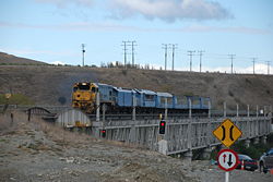
- SeddonSeddon, New ZealandSeddon is a small town in Marlborough, New Zealand. It is located on State Highway 1, 25 kilometres south of Blenheim and 20 km north of Ward...
- Main North Line over Awatere RiverAwatere RiverThe Awatere River is a large river flowing through Marlborough, New Zealand. Flowing along the trace of the active Awatere Fault, it runs northeast through a straight valley to the west of the Inland Kaikoura mountains...
- two level, road under rail (road closed in November 2007); see picture above of TranzCoastal crossing the bridge in April 2007
Former
- Arahura RiverArahura RiverThe Arahura River is a river located on the West Coast of the South Island of New Zealand.It is approximately in length and flows into the Tasman Sea eight kilometers north of Hokitika, next to the Arahura Pa. The lower reaches of the Arahura River was a major producer of gold in the past - and...
- between GreymouthGreymouthGreymouth is the largest town in the West Coast region in the South Island of New Zealand, and the seat of the Grey District Council. The population of the whole Grey District is , which accounts for % of the West Coast's inhabitants...
and Hokitika - single level - replaced in 2009 - RakaiaRakaia RiverThe Rakaia River is in the Canterbury Plains in New Zealand's South Island. The Rakaia River is one of the largest braided rivers in New Zealand...
- separated in 1939 - WaitakiWaitaki RiverThe Waitaki River is a large river in the South Island of New Zealand, some 110 km long. It is the major river of the Mackenzie Basin.It is a braided river which flows through Lake Benmore, Lake Aviemore and Lake Waitaki. These are ultimately fed by three large glacial lakes, Pukaki, Tekapo,...
- Separated around the late 1950s
Norway
- Rødberg Bridge carried the now closed Numedal Line to its terminus in RødbergRødbergRødberg is the administrative centre of Nore og Uvdal municipality, Norway.Rødberg is located in the Norwegian traditional district and valley of Numedal. Its population is 468, and it is located on the Rødberg dam on the Numedalslågen River....
and the highway continuing to GeiloGeilois a centre in the municipality of Hol in Norway, in the valley of Hallingdal, with around 2300 inhabitants.Geilo is primarily a ski resort town, but also offers summer activities. Geilo is in a valley with mountain ranges on each side. The center of the town lies at 800 meters above sea level, and...
over Upsetelva in the center of Rødberg. The rails are still in place, covered by tarmac. There has been no rail traffic on Numedalsbanen since 1988. The railway is in the road, so car traffic had to stop when trains were passing. - Bruhaug Bridge, also on Numedal Line carried both the railway and local car traffic over the river NumedalslågenNumedalslågen-Location:Numedalslågen stretches for over 250 kilometres through the counties of Vestfold and Buskerud, beginning at the Hardangervidda plateau and meeting the ocean at Larvik in Vestfold. Numedalslågen is one of Norway's longest rivers. The rivers runs through the municipalities Larvik, Lardal,...
. The road surface is wood. - Hølendalen Bridge, near MossMossMosses are small, soft plants that are typically 1–10 cm tall, though some species are much larger. They commonly grow close together in clumps or mats in damp or shady locations. They do not have flowers or seeds, and their simple leaves cover the thin wiry stems...
. Motorway and railway, parallel separate bridges. - Nygård BridgeNygård BridgeNygård Bridge is a series of parallel bridges that cross Strømmen, the sound entering Store Lungegårdsvannet, in Bergen, Norway. Old Nygård Bridge dates from 1854 and carries the two tracks of the Bergen Light Rail as well as pedestrians and cyclists. New Nygård Bridge opened in 1978, and carries...
in Bergen carries both the Bergen Light RailBergen Light RailBergen Light Rail is a light rail system in Bergen, Norway. The first stage of the project is a fifteen-station, stretch between the city center and Nesttun, which opened on 22 June 2010...
and a street. A parallel bridge carries European Route E39European route E39E 39 is the designation of a 1330 km long north-south road in Norway and Denmark, running from Klett just south of Trondheim to Aalborg, via Orkanger, Vinjeøra, Halsa ... Straumsnes, Krifast, Batnfjordsøra, Molde ... Vestnes, Skodje, Ålesund ... Volda ... Nordfjordeid ... Sandane, Førde,...
.
Sri Lanka
- Manampitiya Bridge over the Mahaweli River - This narrow bridge is used only for rail since 2006.
- Valaichchenai Bridge (Oddamavadi Bridge) across Valaichchenai lagoon in Eastern ProvinceEastern Province, Sri LankaThe Eastern Province is one of the 9 provinces of Sri Lanka. The provinces have existed since the 19th century but they didn't have any legal status until 1987 when the 13th Amendment to the 1978 Constitution of Sri Lanka established provincial councils. Between 1988 and 2006 the province was...
. - Railway-only since April 2010
Sweden
- Oresund BridgeOresund BridgeThe Øresund or Öresund Bridge is a combined twin-track railway and dual carriageway bridge-tunnel across the Øresund strait.The bridge connects Sweden and Denmark, and it is the longest road and rail bridge in Europe. The Øresund Bridge also connects two major Metropolitan Areas: those of the...
- 8 km long two-level bridge. Road (four lane) on top, rail (two tracks) below. - In the sparsely populated part of Sweden there are some narrow same-track combined road-rail bridges:
- in Oxberg
- in SvegSvegSveg is a locality and the seat of Härjedalen Municipality in Jämtland County, Sweden with 2,633 inhabitants in 2005.The Swedish author Henning Mankell was brought up in Sveg, and it is the setting for his crime novel Danslärarens återkomst .- References :...
( )
) - north of MoskoselMoskoselMoskosel is a locality situated in Arvidsjaur Municipality, Norrbotten County, Sweden with 299 inhabitants in 2005....
( ).
). - in KristianstadKristianstadKristianstad is a city and the seat of Kristianstad Municipality, Skåne County, Sweden with 35,711 inhabitants in 2010.-History:The city was founded in 1614 by King Christian IV of Denmark, the city's name literally means 'Town of Christian', as a planned city after the burning of the town of Vä...
(industry railway, road in the same track) - in NorrköpingNorrköpingNorrköping is a city in the province of Östergötland in eastern Sweden and the seat of Norrköping Municipality, Östergötland County. The city has a population of 87,247 inhabitants in 2010, out of a municipal total of 130,050, making it Sweden's tenth largest city and eighth largest...
(industry railway, road next to the rail)
- Traneberg BridgeTranebergsbronTranebergsbron is a double arch bridge in central Stockholm, Sweden. Stretching over the strait Tranebergssund it connects the major island Kungsholmen to the western suburb Bromma...
- in Stockholm, combined road and subway/metro railRapid transitA rapid transit, underground, subway, elevated railway, metro or metropolitan railway system is an electric passenger railway in an urban area with a high capacity and frequency, and grade separation from other traffic. Rapid transit systems are typically located either in underground tunnels or on...
bridge. - Skanstull BridgeSkanstullsbronSkanstullsbron is a bridge in central Stockholm, Sweden. Overpassing the older bridge Skansbron, it connects the major island Södermalm to the southern district Johanneshov....
- in Stockholm, combined road and subway/metro railRapid transitA rapid transit, underground, subway, elevated railway, metro or metropolitan railway system is an electric passenger railway in an urban area with a high capacity and frequency, and grade separation from other traffic. Rapid transit systems are typically located either in underground tunnels or on...
bridge. - LidingöbronLidingöbronLidingöbron is the name of two existing and two historical bridges across the strait of Lilla Värtan between the mainland Norra Djurgården at Ropsten, at the eastern part of Stockholm - and the island of Lidingö....
- 1 km long parallel road and rail (separate bridges). The road bridge was built 1971; before that the old bridge had road and double track railway in the same carriageway.
United Kingdom
- Britannia BridgeBritannia BridgeBritannia Bridge is a bridge across the Menai Strait between the island of Anglesey and the mainland of Wales. It was originally designed and built by Robert Stephenson as a tubular bridge of wrought iron rectangular box-section spans for carrying rail traffic...
Robert Stephenson's famous bridge across the Menai Strait in Wales. Rebuilt as a road and rail bridge after the fire in 1970. - High Level BridgeHigh Level BridgeThe High Level Bridge is a road and railway bridge spanning the River Tyne between Newcastle upon Tyne and Gateshead in North East England.-Design:...
Newcastle-upon-Tyne. - King George V Bridge, Keadby, North LincolnshireKeadby BridgeKeadby Bridge, more formally known as the King George V Bridge, crosses the River Trent near Althorpe and Keadby in Lincolnshire.-History:...
. Carries the A18 and the DoncasterDoncasterDoncaster is a town in South Yorkshire, England, and the principal settlement of the Metropolitan Borough of Doncaster. The town is about from Sheffield and is popularly referred to as "Donny"...
–ScunthorpeScunthorpeScunthorpe is a town within North Lincolnshire, England. It is the administrative centre of the North Lincolnshire unitary authority, and had an estimated total resident population of 72,514 in 2010. A predominantly industrial town, Scunthorpe, the United Kingdom's largest steel processing centre,...
railway across the River TrentRiver TrentThe River Trent is one of the major rivers of England. Its source is in Staffordshire on the southern edge of Biddulph Moor. It flows through the Midlands until it joins the River Ouse at Trent Falls to form the Humber Estuary, which empties into the North Sea below Hull and Immingham.The Trent...
. Opened in 1916, Althorpe railway stationAlthorpe railway stationAlthorpe railway station serves the village of Althorpe in North Lincolnshire. The station is also very close to the villages of Keadby and Gunness.Stopping services from Sheffield to Scunthorpe call at the station...
is on the western bank of the Trent, very close to the bridge, which has not lifted for some years. - BelfastBelfastBelfast is the capital of and largest city in Northern Ireland. By population, it is the 14th biggest city in the United Kingdom and second biggest on the island of Ireland . It is the seat of the devolved government and legislative Northern Ireland Assembly...
cross-harbour bridge, opened 1994-1995. See The Motorway Archive - Kingsferry road and rail bridgeKingsferry BridgeThe Kingsferry Bridge is a combined road and railway vertical-lift bridge connecting the Isle of Sheppey to Kent in the South East England. It was designed by Mott, Hay and Anderson, and built by John Howard, with Dorman Long and Sir William Arrol...
, Isle of SheppeyIsle of SheppeyThe Isle of Sheppey is an island off the northern coast of Kent, England in the Thames Estuary, some to the east of London. It has an area of . The island forms part of the local government district of Swale...
. Built in 1960, until 2006 this was the only road crossing to the island. The bridge opens 20 times each day. - Connel BridgeConnel BridgeConnel Bridge is a cantilever bridge that spans Loch Etive at Connel in Scotland. The bridge takes the A828 road across the narrowest part of the loch, at the Falls of Lora.- Construction :...
, near Oban, Scotland, was shared until the railway closed in the 1960s. A cantilever bridge. - Britannia BridgePorthmadogPorthmadog , known locally as "Port", and historically rendered into English as Portmadoc, is a small coastal town and community in the Eifionydd area of Gwynedd, in Wales. Prior to the Local Government Act 1972 it was in the administrative county of Caernarfonshire. The town lies east of...
, Porthmadog, Wales, on the Welsh Highland RailwayWelsh Highland RailwayThe Welsh Highland Railway is a long restored narrow gauge heritage railway in North Wales, operating from Caernarfon to Porthmadog, and passing through a number of popular tourist destinations including Beddgelert and the Aberglaslyn Pass. At Porthmadog it connects with the Ffestiniog Railway...
, formerly shared by this narrow gauge line and the main road through the town. The restored line and shared bridge are expected to re-open around 2009.
United States
CaliforniaCalifornia
California is a state located on the West Coast of the United States. It is by far the most populous U.S. state, and the third-largest by land area...
:
- I Street BridgeI Street BridgeThe I Street Bridge is a historic metal truss swing bridge located on I Street in Sacramento, California crossing the Sacramento River connecting Yolo County with Sacramento County...
carries two tracks of AmtrakAmtrakThe National Railroad Passenger Corporation, doing business as Amtrak , is a government-owned corporation that was organized on May 1, 1971, to provide intercity passenger train service in the United States. "Amtrak" is a portmanteau of the words "America" and "track". It is headquartered at Union...
/Union Pacific RailroadUnion Pacific RailroadThe Union Pacific Railroad , headquartered in Omaha, Nebraska, is the largest railroad network in the United States. James R. Young is president, CEO and Chairman....
and two lanes of State Route 16 between SacramentoSacramento, CaliforniaSacramento is the capital city of the U.S. state of California and the county seat of Sacramento County. It is located at the confluence of the Sacramento River and the American River in the northern portion of California's expansive Central Valley. With a population of 466,488 at the 2010 census,...
and West SacramentoWest Sacramento, CaliforniaWest Sacramento is a city in Yolo County, California. It is contiguous with Sacramento, but is separated by the Sacramento River which is also the county line, so West Sacramento is in a different county than Sacramento...
. - San Francisco - Oakland Bay Bridge carried two tracks of Key SystemKey SystemThe Key System was a privately owned company which provided mass transit in the cities of Oakland, Berkeley, Alameda, Emeryville, Piedmont, San Leandro, Richmond, Albany and El Cerrito in the eastern San Francisco Bay Area from 1903 until 1960, when the system was sold to a newly formed public...
between San FranciscoSan Francisco, CaliforniaSan Francisco , officially the City and County of San Francisco, is the financial, cultural, and transportation center of the San Francisco Bay Area, a region of 7.15 million people which includes San Jose and Oakland...
and OaklandOakland, CaliforniaOakland is a major West Coast port city on San Francisco Bay in the U.S. state of California. It is the eighth-largest city in the state with a 2010 population of 390,724...
from 1936 until 1963.
Florida
Florida
Florida is a state in the southeastern United States, located on the nation's Atlantic and Gulf coasts. It is bordered to the west by the Gulf of Mexico, to the north by Alabama and Georgia and to the east by the Atlantic Ocean. With a population of 18,801,310 as measured by the 2010 census, it...
:
- Acosta BridgeAcosta BridgeThe Acosta Bridge spans the St. Johns River in Jacksonville, Florida on a fixed span. It was named for City Councilman St. Elmo W. Acosta, who convinced voters to approve a $950,000 bond issue for the original bridge. It carries SR 13 with the two-track JTA Skyway in the median. Prior to its...
- Carries two monorail tracks for the JTA Skyway and six lanes of State Road 13 in JacksonvilleJacksonville, FloridaJacksonville is the largest city in the U.S. state of Florida in terms of both population and land area, and the largest city by area in the contiguous United States. It is the county seat of Duval County, with which the city government consolidated in 1968...
.
Illinois
Illinois
Illinois is the fifth-most populous state of the United States of America, and is often noted for being a microcosm of the entire country. With Chicago in the northeast, small industrial cities and great agricultural productivity in central and northern Illinois, and natural resources like coal,...
:
- Cherry Avenue BridgeCherry Avenue BridgeThe Cherry Avenue Bridge is an asymmetric bob-tail swing bridge in Chicago, Illinois that carries the Chicago Terminal Railroad, pedestrians, and cyclists across the North Branch Canal of the Chicago River. It was constructed in 1901–02 by the Chicago, Milwaukee and St...
in Chicago. - McKinley BridgeMcKinley BridgeThe McKinley Bridge is a steel truss bridge across the Mississippi River. It connects northern portions of the city of St. Louis, Missouri with Venice, Illinois. It opened in 1910 and was taken out of service on October 30, 2001. The bridge was reopened for pedestrian and bicyclists on November 17,...
- rail removed in 1978.
Iowa
Iowa
Iowa is a state located in the Midwestern United States, an area often referred to as the "American Heartland". It derives its name from the Ioway people, one of the many American Indian tribes that occupied the state at the time of European exploration. Iowa was a part of the French colony of New...
- Illinois
Illinois
Illinois is the fifth-most populous state of the United States of America, and is often noted for being a microcosm of the entire country. With Chicago in the northeast, small industrial cities and great agricultural productivity in central and northern Illinois, and natural resources like coal,...
:
- Fort Madison Toll Bridge - rail on lower deck, road on upper deck--
- Government Bridge - rail on upper deck, road on lower deck, swing-span bridge
Louisiana
Louisiana
Louisiana is a state located in the southern region of the United States of America. Its capital is Baton Rouge and largest city is New Orleans. Louisiana is the only state in the U.S. with political subdivisions termed parishes, which are local governments equivalent to counties...
:
- Almonaster Avenue BridgeAlmonaster Avenue BridgeThe Almonaster Avenue Bridge is a bascule bridge in New Orleans, Louisiana. The bridge has two vehicular lanes of Almonaster Road and two railroad tracks over the Industrial Canal.The bridge is named after Almonaster Avenue on which it is built...
- Bascule drawbridge in New Orleans, LouisianaNew Orleans, LouisianaNew Orleans is a major United States port and the largest city and metropolitan area in the state of Louisiana. The New Orleans metropolitan area has a population of 1,235,650 as of 2009, the 46th largest in the USA. The New Orleans – Metairie – Bogalusa combined statistical area has a population... - Florida Avenue BridgeFlorida Avenue BridgeThe Florida Avenue Bridge is a vertical lift bridge spanning the Industrial Canal in New Orleans, Louisiana. The bridge has one railroad track, two vehicle lanes and two sidewalks...
- Vertical lift drawbridge in New Orleans, LouisianaNew Orleans, LouisianaNew Orleans is a major United States port and the largest city and metropolitan area in the state of Louisiana. The New Orleans metropolitan area has a population of 1,235,650 as of 2009, the 46th largest in the USA. The New Orleans – Metairie – Bogalusa combined statistical area has a population... - Huey P. Long BridgeHuey P. Long Bridge (Jefferson Parish)The Huey P. Long Bridge in Jefferson Parish, Louisiana, is a cantilevered steel through truss bridge that carries a two-track railroad line over the Mississippi River at mile 106.1 with two lanes of US 90 on each side of the central tracks....
- Truss bridge in Jefferson Parish, LouisianaJefferson Parish, LouisianaJefferson Parish is a parish in Louisiana, United States that includes most of the suburbs of New Orleans. The seat of parish government is Gretna....
. - Huey P. Long BridgeHuey P. Long Bridge (Baton Rouge)The Huey P. Long Bridge is a truss cantilever bridge over the Mississippi River carrying US 190 and one rail line between East Baton Rouge Parish, Louisiana and West Baton Rouge Parish, Louisiana....
- Truss bridge in Baton Rouge, LouisianaBaton Rouge, LouisianaBaton Rouge is the capital of the U.S. state of Louisiana. It is located in East Baton Rouge Parish and is the second-largest city in the state.Baton Rouge is a major industrial, petrochemical, medical, and research center of the American South...
. - St. Claude Avenue BridgeSt. Claude Avenue BridgeThe St. Claude Avenue Bridge is a bascule bridge with four vehicular lanes over the Industrial Canal in New Orleans, Louisiana. This was originally a combination railroad and automobile bridge, with two pairs of railroad tracks in the center of the lift span and automobile lanes straddling it...
- former road and rail bridge, nowadays it serves automotive and pedestrian traffic. New Orleans
Kentucky
Kentucky
The Commonwealth of Kentucky is a state located in the East Central United States of America. As classified by the United States Census Bureau, Kentucky is a Southern state, more specifically in the East South Central region. Kentucky is one of four U.S. states constituted as a commonwealth...
:
- Kentucky & Indiana Terminal BridgeKentucky & Indiana Terminal BridgeThe Kentucky & Indiana Terminal Bridge is a railroad bridge connecting the Louisville, Kentucky, area to New Albany, Indiana. Constructed from 1881 to 1885 by the Kentucky and Indiana Bridge Company, it opened in 1886...
- Truss bridge between Louisville, KentuckyLouisville, KentuckyLouisville is the largest city in the U.S. state of Kentucky, and the county seat of Jefferson County. Since 2003, the city's borders have been coterminous with those of the county because of a city-county merger. The city's population at the 2010 census was 741,096...
and New Albany, IndianaNew Albany, IndianaNew Albany is a city in Floyd County, Indiana, United States, situated along the Ohio River opposite Louisville, Kentucky. In 1900, 20,628 people lived in New Albany; in 1910, 20,629; in 1920, 22,992; and in 1940, 25,414. The population was 36,372 at the 2010 census. The city is the county seat of...
over the Ohio RiverOhio RiverThe Ohio River is the largest tributary, by volume, of the Mississippi River. At the confluence, the Ohio is even bigger than the Mississippi and, thus, is hydrologically the main stream of the whole river system, including the Allegheny River further upstream...
. Road portion closed in 1979 when roadway collapsed under an overweight truck.
Minnesota
Minnesota
Minnesota is a U.S. state located in the Midwestern United States. The twelfth largest state of the U.S., it is the twenty-first most populous, with 5.3 million residents. Minnesota was carved out of the eastern half of the Minnesota Territory and admitted to the Union as the thirty-second state...
:
- Oliver BridgeOliver BridgeThe Oliver Bridge was constructed across the St. Louis River in 1916 by the Interstate Transfer Railway Company, a Wisconsin corporation, under special federal authorization from the 60th United States Congress . It connects Gary - New Duluth, part of the City of Duluth, Minnesota with Oliver,...
connecting Duluth, Minnesota and Oliver, Wisconsin. Rail on upper deck, road on lower deck.
Missouri
Missouri
Missouri is a US state located in the Midwestern United States, bordered by Iowa, Illinois, Kentucky, Tennessee, Arkansas, Oklahoma, Kansas and Nebraska. With a 2010 population of 5,988,927, Missouri is the 18th most populous state in the nation and the fifth most populous in the Midwest. It...
:
- Second Hannibal BridgeSecond Hannibal BridgeThe second Hannibal Bridge is a rail bridge over the Missouri River in Kansas City, Missouri connecting Jackson County, Missouri with Clay County, Missouri....
in Kansas City, Missouri across the Missouri RiverMissouri RiverThe Missouri River flows through the central United States, and is a tributary of the Mississippi River. It is the longest river in North America and drains the third largest area, though only the thirteenth largest by discharge. The Missouri's watershed encompasses most of the American Great...
. Opened in 1917, had a road deck until 1956, when another bridge was built, but the rail deck is presently in use. Evidence of the road deck is still plainly visible. - Eads BridgeEads BridgeThe Eads Bridge is a combined road and railway bridge over the Mississippi River at St. Louis, connecting St. Louis and East St. Louis, Illinois....
in St. Louis, Missouri across the Mississippi RiverMississippi RiverThe Mississippi River is the largest river system in North America. Flowing entirely in the United States, this river rises in western Minnesota and meanders slowly southwards for to the Mississippi River Delta at the Gulf of Mexico. With its many tributaries, the Mississippi's watershed drains...
. Opened in 1874. It carries the road traffic on the upper deck and the St. Louis MetroLinkSt. Louis MetrolinkMetroLink is the light rail transit system in the Greater St. Louis area of Missouri and the Metro East area of Illinois. The entire system currently consists of two lines connecting Lambert-St. Louis International Airport and Shrewsbury, MO with Scott Air Force Base near Shiloh, Illinois through...
on the lower deck.
Ohio
Ohio
Ohio is a Midwestern state in the United States. The 34th largest state by area in the U.S.,it is the 7th‑most populous with over 11.5 million residents, containing several major American cities and seven metropolitan areas with populations of 500,000 or more.The state's capital is Columbus...
:
- Clay Wade Bailey BridgeClay Wade Bailey BridgeThe Clay Wade Bailey Bridge is a cantilever bridge carrying U.S. Route 42 and U.S. Route 127 across the Ohio River, connecting Cincinnati, Ohio and Covington, Kentucky. This also marks the termination of U.S. Route 25. The bridge's main span is...
/C&O Railroad Bridge - Cincinnati, OhioCincinnati, OhioCincinnati is a city in the U.S. state of Ohio. Cincinnati is the county seat of Hamilton County. Settled in 1788, the city is located to north of the Ohio River at the Ohio-Kentucky border, near Indiana. The population within city limits is 296,943 according to the 2010 census, making it Ohio's...
to Newport, KentuckyNewport, KentuckyNewport is a city in Campbell County, Kentucky, United States, at the confluence of the Ohio and Licking rivers. The population was 15,273 at the 2010 census. Historically, it was one of four county seats of Campbell County. Newport is part of the Greater Cincinnati, Ohio Metro Area which...
over the Ohio RiverOhio RiverThe Ohio River is the largest tributary, by volume, of the Mississippi River. At the confluence, the Ohio is even bigger than the Mississippi and, thus, is hydrologically the main stream of the whole river system, including the Allegheny River further upstream...
. (Technically, these are two separate bridges, but they are spaced very closely adjacent to each other and built on common piers.)
New York
New York
New York is a state in the Northeastern region of the United States. It is the nation's third most populous state. New York is bordered by New Jersey and Pennsylvania to the south, and by Connecticut, Massachusetts and Vermont to the east...
:
- Broadway Bridge - Road and elevated subway (the 1 line) bridge in New York City
- Manhattan BridgeManhattan BridgeThe Manhattan Bridge is a suspension bridge that crosses the East River in New York City, connecting Lower Manhattan with Brooklyn . It was the last of the three suspension bridges built across the lower East River, following the Brooklyn and the Williamsburg bridges...
- Road and elevated subway (B, D, N, Q lines) bridge in New York City - Williamsburg BridgeWilliamsburg BridgeThe Williamsburg Bridge is a suspension bridge in New York City across the East River connecting the Lower East Side of Manhattan at Delancey Street with the Williamsburg neighborhood of Brooklyn at Broadway near the Brooklyn-Queens Expressway...
- Road and elevated subway (J, M, Z lines) bridge in New York City
Pennsylvania
Pennsylvania
The Commonwealth of Pennsylvania is a U.S. state that is located in the Northeastern and Mid-Atlantic regions of the United States. The state borders Delaware and Maryland to the south, West Virginia to the southwest, Ohio to the west, New York and Ontario, Canada, to the north, and New Jersey to...
:
- Benjamin Franklin BridgeBenjamin Franklin BridgeThe Benjamin Franklin Bridge , originally named the Delaware River Bridge, is a suspension bridge across the Delaware River connecting Philadelphia, Pennsylvania and Camden, New Jersey...
- Suspension bridge carrying I-676Interstate 676Interstate 676 is an Interstate Highway that serves as a major thoroughfare through Philadelphia, Pennsylvania, where it is known as the Vine Street Expressway, and Camden, New Jersey, where it is known as the northern segment of the North–South Freeway, as well as the Martin Luther King Jr....
and PATCO Speedline trains between Philadelphia, PennsylvaniaPennsylvaniaThe Commonwealth of Pennsylvania is a U.S. state that is located in the Northeastern and Mid-Atlantic regions of the United States. The state borders Delaware and Maryland to the south, West Virginia to the southwest, Ohio to the west, New York and Ontario, Canada, to the north, and New Jersey to...
, and Camden, New JerseyCamden, New JerseyThe city of Camden is the county seat of Camden County, New Jersey. It is located across the Delaware River from Philadelphia, Pennsylvania. As of the 2010 United States Census, the city had a total population of 77,344...
.
Massachusetts
Massachusetts
The Commonwealth of Massachusetts is a state in the New England region of the northeastern United States of America. It is bordered by Rhode Island and Connecticut to the south, New York to the west, and Vermont and New Hampshire to the north; at its east lies the Atlantic Ocean. As of the 2010...
:
- Longfellow BridgeLongfellow BridgeThe Longfellow Bridge, also known to locals as the "Salt-and-Pepper Bridge" or the "Salt-and-Pepper-Shaker Bridge" due to the shape of its central towers, carries Route 3 and the Massachusetts Bay Transportation Authority's Red Line across the Charles River to connect Boston's Beacon Hill...
- Four lane road with two subway tracks running down the centre of the bridge connecting BostonBostonBoston is the capital of and largest city in Massachusetts, and is one of the oldest cities in the United States. The largest city in New England, Boston is regarded as the unofficial "Capital of New England" for its economic and cultural impact on the entire New England region. The city proper had...
and CambridgeCambridgeThe city of Cambridge is a university town and the administrative centre of the county of Cambridgeshire, England. It lies in East Anglia about north of London. Cambridge is at the heart of the high-technology centre known as Silicon Fen – a play on Silicon Valley and the fens surrounding the...
over the Charles River.
Oregon
Oregon
Oregon is a state in the Pacific Northwest region of the United States. It is located on the Pacific coast, with Washington to the north, California to the south, Nevada on the southeast and Idaho to the east. The Columbia and Snake rivers delineate much of Oregon's northern and eastern...
:
- Steel BridgeSteel BridgeThe Steel Bridge is a through truss, double lift bridge across the Willamette River in Portland, Oregon, United States. Its lower deck carries railroad and bicycle/pedestrian traffic, while the upper deck carries road traffic and light rail , making the bridge one of the most multimodal in the world...
- A through truss, double lift bridge across the Willamette RiverWillamette RiverThe Willamette River is a major tributary of the Columbia River, accounting for 12 to 15 percent of the Columbia's flow. The Willamette's main stem is long, lying entirely in northwestern Oregon in the United States...
in Portland, OregonPortland, OregonPortland is a city located in the Pacific Northwest, near the confluence of the Willamette and Columbia rivers in the U.S. state of Oregon. As of the 2010 Census, it had a population of 583,776, making it the 29th most populous city in the United States...
Carrying pedestrian, rail, automobile, bus, MAX Light Rail and vintage streetcar making it one of the most multi-modal bridges in the world.
UzbekistanUzbekistanUzbekistan , officially the Republic of Uzbekistan is a doubly landlocked country in Central Asia and one of the six independent Turkic states. It shares borders with Kazakhstan to the west and to the north, Kyrgyzstan and Tajikistan to the east, and Afghanistan and Turkmenistan to the south....
- Amu DaryaAmu DaryaThe Amu Darya , also called Oxus and Amu River, is a major river in Central Asia. It is formed by the junction of the Vakhsh and Panj rivers...
Bridge is the first bridge between KhorezmXorazm ProvinceXorazm Province or Khorezm Province as it is still more commonly known, is a viloyat of Uzbekistan located in the northwest of the country in the lower reaches of the Amu-Darya River. It borders with Turkmenistan, Karakalpakstan, and Buxoro Province. It covers an area of 6,300 km²...
and Karakalpakstan, opened March 2004. It only has one track with the rails embedded into tarmac, used for trains and cars, one direction at a time, and is 681 m long. It now doubles the pontoon bridge that was the only link between Khorezm and the rest of Uzbekistan. - See above for the cross-border bridge to Afghanistan
Proposed
- BangladeshBangladeshBangladesh , officially the People's Republic of Bangladesh is a sovereign state located in South Asia. It is bordered by India on all sides except for a small border with Burma to the far southeast and by the Bay of Bengal to the south...
- PadmaPadma RiverThe Padma is a major trans-boundary river in Bangladesh. It is the main distributary of the Ganges , which originates in the Himalayas. The Padma enters Bangladesh from India near Chapai Nababganj...
bridge - Germany/Denmark - Fehmarn Belt bridgeFehmarn Belt bridgeThe Fehmarn Belt Fixed Link is an immersed tunnel that is proposed to connect the German offshore island of Fehmarn with the Danish island of Lolland...
- Italy - Messina Bridge
- Republic of the CongoRepublic of the CongoThe Republic of the Congo , sometimes known locally as Congo-Brazzaville, is a state in Central Africa. It is bordered by Gabon, Cameroon, the Central African Republic, the Democratic Republic of the Congo , the Angolan exclave province of Cabinda, and the Gulf of Guinea.The region was dominated by...
- Democratic Republic of the CongoDemocratic Republic of the CongoThe Democratic Republic of the Congo is a state located in Central Africa. It is the second largest country in Africa by area and the eleventh largest in the world...
- Brazzaville-Kinshasa BridgeBrazzaville-Kinshasa BridgeThe Brazzaville–Kinshasa Bridge is a proposed road-rail bridge planned to connect Brazzaville in the Republic of Congo and Kinshasa in the Democratic Republic of the Congo, which are large cities astride the mighty Congo River that are capitals of their respective countries.- Advantages :* Amongst... - YemenYemenThe Republic of Yemen , commonly known as Yemen , is a country located in the Middle East, occupying the southwestern to southern end of the Arabian Peninsula. It is bordered by Saudi Arabia to the north, the Red Sea to the west, and Oman to the east....
- DjiboutiDjiboutiDjibouti , officially the Republic of Djibouti , is a country in the Horn of Africa. It is bordered by Eritrea in the north, Ethiopia in the west and south, and Somalia in the southeast. The remainder of the border is formed by the Red Sea and the Gulf of Aden at the east...
- Bridge of the Horns - BotswanaBotswanaBotswana, officially the Republic of Botswana , is a landlocked country located in Southern Africa. The citizens are referred to as "Batswana" . Formerly the British protectorate of Bechuanaland, Botswana adopted its new name after becoming independent within the Commonwealth on 30 September 1966...
- ZambiaZambiaZambia , officially the Republic of Zambia, is a landlocked country in Southern Africa. The neighbouring countries are the Democratic Republic of the Congo to the north, Tanzania to the north-east, Malawi to the east, Mozambique, Zimbabwe, Botswana and Namibia to the south, and Angola to the west....
- KazungulaKazungulaKazungula is a small border town in the Southern Province of Zambia, lying on the north bank of the Zambezi River about 70 km west of Livingstone, at an almost quadripoint where four countries nearly meet...
bridge - 2010
See also
- List of bridges
- List of road-rail tunnels
- List of bridge-tunnels
- Street runningStreet runningOn-street running or street running is when a railroad track or tramway track runs directly along city streets, without any separation. The rails are embedded in the road....
- Train ferryTrain ferryA train ferry is a ship designed to carry railway vehicles. Typically, one level of the ship is fitted with railway tracks, and the vessel has a door at the front and/or rear to give access to the wharves. In the United States, train ferries are sometimes referred to as "car ferries", as...