

List of regions of the United States
Encyclopedia
The List of regions of the United States provides links to both interstate and intrastate regions.
Official U.S. regions
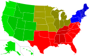
Many regions in the United States are defined in law or regulations by the federal government.Census Bureau-designated areas
Regional divisions used by the United States Census BureauUnited States Census Bureau
The United States Census Bureau is the government agency that is responsible for the United States Census. It also gathers other national demographic and economic data...
:
- Region 1 (NortheastNortheastern United StatesThe Northeastern United States is a region of the United States as defined by the United States Census Bureau.-Composition:The region comprises nine states: the New England states of Connecticut, Maine, Massachusetts, New Hampshire, Rhode Island and Vermont; and the Mid-Atlantic states of New...
)- Division 1 (New EnglandNew EnglandNew England is a region in the northeastern corner of the United States consisting of the six states of Maine, New Hampshire, Vermont, Massachusetts, Rhode Island, and Connecticut...
) MaineMaineMaine is a state in the New England region of the northeastern United States, bordered by the Atlantic Ocean to the east and south, New Hampshire to the west, and the Canadian provinces of Quebec to the northwest and New Brunswick to the northeast. Maine is both the northernmost and easternmost...
, New HampshireNew HampshireNew Hampshire is a state in the New England region of the northeastern United States of America. The state was named after the southern English county of Hampshire. It is bordered by Massachusetts to the south, Vermont to the west, Maine and the Atlantic Ocean to the east, and the Canadian...
, VermontVermontVermont is a state in the New England region of the northeastern United States of America. The state ranks 43rd in land area, , and 45th in total area. Its population according to the 2010 census, 630,337, is the second smallest in the country, larger only than Wyoming. It is the only New England...
, MassachusettsMassachusettsThe Commonwealth of Massachusetts is a state in the New England region of the northeastern United States of America. It is bordered by Rhode Island and Connecticut to the south, New York to the west, and Vermont and New Hampshire to the north; at its east lies the Atlantic Ocean. As of the 2010...
, Rhode IslandRhode IslandThe state of Rhode Island and Providence Plantations, more commonly referred to as Rhode Island , is a state in the New England region of the United States. It is the smallest U.S. state by area...
, ConnecticutConnecticutConnecticut is a state in the New England region of the northeastern United States. It is bordered by Rhode Island to the east, Massachusetts to the north, and the state of New York to the west and the south .Connecticut is named for the Connecticut River, the major U.S. river that approximately... - Division 2 (Mid-AtlanticMid-Atlantic StatesThe Mid-Atlantic states, also called middle Atlantic states or simply the mid Atlantic, form a region of the United States generally located between New England and the South...
) New YorkNew YorkNew York is a state in the Northeastern region of the United States. It is the nation's third most populous state. New York is bordered by New Jersey and Pennsylvania to the south, and by Connecticut, Massachusetts and Vermont to the east...
, PennsylvaniaPennsylvaniaThe Commonwealth of Pennsylvania is a U.S. state that is located in the Northeastern and Mid-Atlantic regions of the United States. The state borders Delaware and Maryland to the south, West Virginia to the southwest, Ohio to the west, New York and Ontario, Canada, to the north, and New Jersey to...
, New JerseyNew JerseyNew Jersey is a state in the Northeastern and Middle Atlantic regions of the United States. , its population was 8,791,894. It is bordered on the north and east by the state of New York, on the southeast and south by the Atlantic Ocean, on the west by Pennsylvania and on the southwest by Delaware...
- Division 1 (New England
- Region 2 (MidwestMidwestern United StatesThe Midwestern United States is one of the four U.S. geographic regions defined by the United States Census Bureau, providing an official definition of the American Midwest....
) (Prior to June 1984, the Midwest Region was designated as the North Central Region.)- Division 3 (East North CentralEast North Central StatesThe East North Central States form one of the nine geographic divisions within the United States which are officially recognized by the United States Census Bureau....
) WisconsinWisconsinWisconsin is a U.S. state located in the north-central United States and is part of the Midwest. It is bordered by Minnesota to the west, Iowa to the southwest, Illinois to the south, Lake Michigan to the east, Michigan to the northeast, and Lake Superior to the north. Wisconsin's capital is...
, MichiganMichiganMichigan is a U.S. state located in the Great Lakes Region of the United States of America. The name Michigan is the French form of the Ojibwa word mishigamaa, meaning "large water" or "large lake"....
, IllinoisIllinoisIllinois is the fifth-most populous state of the United States of America, and is often noted for being a microcosm of the entire country. With Chicago in the northeast, small industrial cities and great agricultural productivity in central and northern Illinois, and natural resources like coal,...
, IndianaIndianaIndiana is a US state, admitted to the United States as the 19th on December 11, 1816. It is located in the Midwestern United States and Great Lakes Region. With 6,483,802 residents, the state is ranked 15th in population and 16th in population density. Indiana is ranked 38th in land area and is...
, OhioOhioOhio is a Midwestern state in the United States. The 34th largest state by area in the U.S.,it is the 7th‑most populous with over 11.5 million residents, containing several major American cities and seven metropolitan areas with populations of 500,000 or more.The state's capital is Columbus... - Division 4 (West North CentralWest North Central StatesThe West North Central States form one of the nine geographic divisions within the United States that are officially recognized by the U.S. Census Bureau....
) MissouriMissouriMissouri is a US state located in the Midwestern United States, bordered by Iowa, Illinois, Kentucky, Tennessee, Arkansas, Oklahoma, Kansas and Nebraska. With a 2010 population of 5,988,927, Missouri is the 18th most populous state in the nation and the fifth most populous in the Midwest. It...
, North DakotaNorth DakotaNorth Dakota is a state located in the Midwestern region of the United States of America, along the Canadian border. The state is bordered by Canada to the north, Minnesota to the east, South Dakota to the south and Montana to the west. North Dakota is the 19th-largest state by area in the U.S....
, South DakotaSouth DakotaSouth Dakota is a state located in the Midwestern region of the United States. It is named after the Lakota and Dakota Sioux American Indian tribes. Once a part of Dakota Territory, South Dakota became a state on November 2, 1889. The state has an area of and an estimated population of just over...
, NebraskaNebraskaNebraska is a state on the Great Plains of the Midwestern United States. The state's capital is Lincoln and its largest city is Omaha, on the Missouri River....
, KansasKansasKansas is a US state located in the Midwestern United States. It is named after the Kansas River which flows through it, which in turn was named after the Kansa Native American tribe, which inhabited the area. The tribe's name is often said to mean "people of the wind" or "people of the south...
, MinnesotaMinnesotaMinnesota is a U.S. state located in the Midwestern United States. The twelfth largest state of the U.S., it is the twenty-first most populous, with 5.3 million residents. Minnesota was carved out of the eastern half of the Minnesota Territory and admitted to the Union as the thirty-second state...
, IowaIowaIowa is a state located in the Midwestern United States, an area often referred to as the "American Heartland". It derives its name from the Ioway people, one of the many American Indian tribes that occupied the state at the time of European exploration. Iowa was a part of the French colony of New...
- Division 3 (East North Central
- Region 3 (SouthSouthern United StatesThe Southern United States—commonly referred to as the American South, Dixie, or simply the South—constitutes a large distinctive area in the southeastern and south-central United States...
)- Division 5 (South AtlanticSouth Atlantic StatesThe South Atlantic United States form one of the nine Census Bureau Divisions within the United States that are recognized by the United States Census Bureau....
) DelawareDelawareDelaware is a U.S. state located on the Atlantic Coast in the Mid-Atlantic region of the United States. It is bordered to the south and west by Maryland, and to the north by Pennsylvania...
, MarylandMarylandMaryland is a U.S. state located in the Mid Atlantic region of the United States, bordering Virginia, West Virginia, and the District of Columbia to its south and west; Pennsylvania to its north; and Delaware to its east...
, District of Columbia, VirginiaVirginiaThe Commonwealth of Virginia , is a U.S. state on the Atlantic Coast of the Southern United States. Virginia is nicknamed the "Old Dominion" and sometimes the "Mother of Presidents" after the eight U.S. presidents born there...
, West VirginiaWest VirginiaWest Virginia is a state in the Appalachian and Southeastern regions of the United States, bordered by Virginia to the southeast, Kentucky to the southwest, Ohio to the northwest, Pennsylvania to the northeast and Maryland to the east...
, North CarolinaNorth CarolinaNorth Carolina is a state located in the southeastern United States. The state borders South Carolina and Georgia to the south, Tennessee to the west and Virginia to the north. North Carolina contains 100 counties. Its capital is Raleigh, and its largest city is Charlotte...
, South CarolinaSouth CarolinaSouth Carolina is a state in the Deep South of the United States that borders Georgia to the south, North Carolina to the north, and the Atlantic Ocean to the east. Originally part of the Province of Carolina, the Province of South Carolina was one of the 13 colonies that declared independence...
, GeorgiaGeorgia (U.S. state)Georgia is a state located in the southeastern United States. It was established in 1732, the last of the original Thirteen Colonies. The state is named after King George II of Great Britain. Georgia was the fourth state to ratify the United States Constitution, on January 2, 1788...
, FloridaFloridaFlorida is a state in the southeastern United States, located on the nation's Atlantic and Gulf coasts. It is bordered to the west by the Gulf of Mexico, to the north by Alabama and Georgia and to the east by the Atlantic Ocean. With a population of 18,801,310 as measured by the 2010 census, it... - Division 6 (East South CentralEast South Central StatesThe East South Central States constitute one of the nine Census Bureau Divisions of the United States.Four states make up the division: Alabama, Kentucky, Mississippi, and Tennessee...
) KentuckyKentuckyThe Commonwealth of Kentucky is a state located in the East Central United States of America. As classified by the United States Census Bureau, Kentucky is a Southern state, more specifically in the East South Central region. Kentucky is one of four U.S. states constituted as a commonwealth...
, TennesseeTennesseeTennessee is a U.S. state located in the Southeastern United States. It has a population of 6,346,105, making it the nation's 17th-largest state by population, and covers , making it the 36th-largest by total land area...
, MississippiMississippiMississippi is a U.S. state located in the Southern United States. Jackson is the state capital and largest city. The name of the state derives from the Mississippi River, which flows along its western boundary, whose name comes from the Ojibwe word misi-ziibi...
, AlabamaAlabamaAlabama is a state located in the southeastern region of the United States. It is bordered by Tennessee to the north, Georgia to the east, Florida and the Gulf of Mexico to the south, and Mississippi to the west. Alabama ranks 30th in total land area and ranks second in the size of its inland... - Division 7 (West South CentralWest South Central StatesThe West South Central States form one of the nine Census Bureau Divisions of the United States that are officially designated by the United States Census Bureau.Four states compose the division: Arkansas, Louisiana, Oklahoma, and Texas...
) OklahomaOklahomaOklahoma is a state located in the South Central region of the United States of America. With an estimated 3,751,351 residents as of the 2010 census and a land area of 68,667 square miles , Oklahoma is the 28th most populous and 20th-largest state...
, TexasTexasTexas is the second largest U.S. state by both area and population, and the largest state by area in the contiguous United States.The name, based on the Caddo word "Tejas" meaning "friends" or "allies", was applied by the Spanish to the Caddo themselves and to the region of their settlement in...
, ArkansasArkansasArkansas is a state located in the southern region of the United States. Its name is an Algonquian name of the Quapaw Indians. Arkansas shares borders with six states , and its eastern border is largely defined by the Mississippi River...
, LouisianaLouisianaLouisiana is a state located in the southern region of the United States of America. Its capital is Baton Rouge and largest city is New Orleans. Louisiana is the only state in the U.S. with political subdivisions termed parishes, which are local governments equivalent to counties...
- Division 5 (South Atlantic
- Region 4 (WestWestern United States.The Western United States, commonly referred to as the American West or simply "the West," traditionally refers to the region comprising the westernmost states of the United States. Because the U.S. expanded westward after its founding, the meaning of the West has evolved over time...
)- Division 8 (MountainMountain Statesthumb|300px|Regional definitions vary from source to source. The states shown in dark red are always included, while the striped states are usually considered part of the same region called the Mountain States....
) IdahoIdahoIdaho is a state in the Rocky Mountain area of the United States. The state's largest city and capital is Boise. Residents are called "Idahoans". Idaho was admitted to the Union on July 3, 1890, as the 43rd state....
, MontanaMontanaMontana is a state in the Western United States. The western third of Montana contains numerous mountain ranges. Smaller, "island ranges" are found in the central third of the state, for a total of 77 named ranges of the Rocky Mountains. This geographical fact is reflected in the state's name,...
, WyomingWyomingWyoming is a state in the mountain region of the Western United States. The western two thirds of the state is covered mostly with the mountain ranges and rangelands in the foothills of the Eastern Rocky Mountains, while the eastern third of the state is high elevation prairie known as the High...
, NevadaNevadaNevada is a state in the western, mountain west, and southwestern regions of the United States. With an area of and a population of about 2.7 million, it is the 7th-largest and 35th-most populous state. Over two-thirds of Nevada's people live in the Las Vegas metropolitan area, which contains its...
, UtahUtahUtah is a state in the Western United States. It was the 45th state to join the Union, on January 4, 1896. Approximately 80% of Utah's 2,763,885 people live along the Wasatch Front, centering on Salt Lake City. This leaves vast expanses of the state nearly uninhabited, making the population the...
, ColoradoColoradoColorado is a U.S. state that encompasses much of the Rocky Mountains as well as the northeastern portion of the Colorado Plateau and the western edge of the Great Plains...
, ArizonaArizonaArizona ; is a state located in the southwestern region of the United States. It is also part of the western United States and the mountain west. The capital and largest city is Phoenix...
, New MexicoNew MexicoNew Mexico is a state located in the southwest and western regions of the United States. New Mexico is also usually considered one of the Mountain States. With a population density of 16 per square mile, New Mexico is the sixth-most sparsely inhabited U.S... - Division 9 (PacificPacific StatesThe Pacific States form one of the nine geographic divisions within the United States that are officially recognized by that country's census bureau. There are five states in this division — Alaska, California, Hawaii, Oregon, Washington — and, as its name suggests, they all have...
) AlaskaAlaskaAlaska is the largest state in the United States by area. It is situated in the northwest extremity of the North American continent, with Canada to the east, the Arctic Ocean to the north, and the Pacific Ocean to the west and south, with Russia further west across the Bering Strait...
, Washington, OregonOregonOregon is a state in the Pacific Northwest region of the United States. It is located on the Pacific coast, with Washington to the north, California to the south, Nevada on the southeast and Idaho to the east. The Columbia and Snake rivers delineate much of Oregon's northern and eastern...
, CaliforniaCaliforniaCalifornia is a state located on the West Coast of the United States. It is by far the most populous U.S. state, and the third-largest by land area...
, HawaiiHawaiiHawaii is the newest of the 50 U.S. states , and is the only U.S. state made up entirely of islands. It is the northernmost island group in Polynesia, occupying most of an archipelago in the central Pacific Ocean, southwest of the continental United States, southeast of Japan, and northeast of...
- Division 8 (Mountain
Standard Federal Regions
The ten standard Federal Regions were established by OMB (Office of Management and Budget) Circular A-105, "Standard Federal Regions," in April, 1974, and required for all executive agencies. In recent years, some agencies have tailored their field structures to meet program needs and facilitate interaction with local, state and regional counterparts. However, the OMB must still approve any departures.- Region I: Connecticut, Maine, Massachusetts, New Hampshire, Rhode Island, Vermont
- Region II: New Jersey, New York, Puerto Rico, Virgin Islands
- Region III: Delaware, District of Columbia, Maryland, Pennsylvania, Virginia, West Virginia
- Region IV: Alabama, Florida, Georgia, Kentucky, Mississippi, North Carolina, South Carolina, Tennessee
- Region V: Illinois, Indiana, Michigan, Minnesota, Ohio, Wisconsin
- Region VI: Arkansas, Louisiana, New Mexico, Oklahoma, Texas
- Region VII: Iowa, Kansas, Missouri, Nebraska
- Region VIII: Colorado, Montana, North Dakota, South Dakota, Utah, Wyoming
- Region IX: Arizona, California, Hawaii, Nevada (American Samoa, Guam, Northern Mariana Islands, Trust Territory of the Pacific Islands)
- Region X: Alaska, Idaho, Oregon, Washington
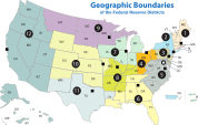
Federal Reserve banks
Federal Reserve Act
The Federal Reserve Act is an Act of Congress that created and set up the Federal Reserve System, the central banking system of the United States of America, and granted it the legal authority to issue Federal Reserve Notes and Federal Reserve Bank Notes as legal tender...
divided the country into twelve districts with a central Federal Reserve Bank
Federal Reserve Bank
The twelve Federal Reserve Banks form a major part of the Federal Reserve System, the central banking system of the United States. The twelve federal reserve banks together divide the nation into twelve Federal Reserve Districts, the twelve banking districts created by the Federal Reserve Act of...
in each district. These twelve Federal Reserve Banks together form a major part of the Federal Reserve System
Federal Reserve System
The Federal Reserve System is the central banking system of the United States. It was created on December 23, 1913 with the enactment of the Federal Reserve Act, largely in response to a series of financial panics, particularly a severe panic in 1907...
, the central bank
Central bank
A central bank, reserve bank, or monetary authority is a public institution that usually issues the currency, regulates the money supply, and controls the interest rates in a country. Central banks often also oversee the commercial banking system of their respective countries...
ing system of the United States.
- BostonFederal Reserve Bank of BostonThe Federal Reserve Bank of Boston, commonly known as the Boston Fed, is responsible for the First District of the Federal Reserve, which covers most of Connecticut , Massachusetts, Maine, New Hampshire, Rhode Island and Vermont. It is headquartered in the Federal Reserve Bank Building in Boston,...
- New YorkFederal Reserve Bank of New YorkThe Federal Reserve Bank of New York is one of the 12 Federal Reserve Banks of the United States. It is located at 33 Liberty Street, New York, NY. It is responsible for the Second District of the Federal Reserve System, which encompasses New York state, the 12 northern counties of New Jersey,...
- PhiladelphiaFederal Reserve Bank of PhiladelphiaThe Federal Reserve Bank of Philadelphia, headquartered in Philadelphia, Pennsylvania, is responsible for the Third District of the Federal Reserve, which covers eastern Pennsylvania, the 9 southern counties of New Jersey, and Delaware...
- ClevelandFederal Reserve Bank of ClevelandThe Federal Reserve Bank of Cleveland is the Cleveland-based headquarters of the U.S. Federal Reserve System's Fourth District. The district is composed of Ohio, western Pennsylvania, eastern Kentucky, and the northern panhandle of West Virginia. It has branch offices in Cincinnati and Pittsburgh....
- RichmondFederal Reserve Bank of RichmondThe Federal Reserve Bank of Richmond is the headquarters of the Fifth District of the Federal Reserve located in Richmond, Virginia. It covers the District of Columbia, Maryland, Virginia, North Carolina, South Carolina and most of West Virginia. Branch offices are located in Baltimore, Maryland...
- AtlantaFederal Reserve Bank of AtlantaThe Federal Reserve Bank of Atlanta is responsible for the sixth district, which covers the states of Alabama, Florida, and Georgia, 74 counties in the eastern two-thirds of...
- ChicagoFederal Reserve Bank of ChicagoThe Federal Reserve Bank of Chicago is one of twelve regional Reserve Banks that, along with the Board of Governors in Washington, D.C., make up the nation's central bank....
- St. Louis
- MinneapolisFederal Reserve Bank of MinneapolisThe Federal Reserve Bank of Minneapolis, located in Minneapolis, Minnesota, in the United States, covers the 9th District of the Federal Reserve, including Minnesota, Montana, North and South Dakota, northwestern Wisconsin, and the Upper Peninsula of Michigan...
- Kansas CityFederal Reserve Bank of Kansas CityThe Federal Reserve Bank of Kansas City covers the 10th District of the Federal Reserve, which includes Colorado, Kansas, Nebraska, Oklahoma, Wyoming, and portions of western Missouri and northern New Mexico. The Bank has branches in Denver, Oklahoma City, and Omaha. The current president is...
- DallasFederal Reserve Bank of DallasThe Federal Reserve Bank of Dallas covers the Eleventh Federal Reserve District, which includes Texas, northern Louisiana and southern New Mexico....
- San FranciscoFederal Reserve Bank of San FranciscoThe Federal Reserve Bank of San Francisco is the federal bank for the twelfth district in the United States. The twelfth district is made up of nine western states-—Alaska, Arizona, California, Hawaii, Idaho, Nevada, Oregon, Utah, and Washington--plus the Northern Mariana Islands, American Samoa,...
Time Zones
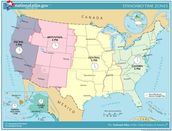
- Hawaii-Aleutian Time ZoneHawaii-Aleutian time zoneThe Hawaii-Aleutian Time Zone observes Hawaii-Aleutian Standard Time , by subtracting ten hours from Coordinated Universal Time . The clock time in this zone is based on the mean solar time of the 150th meridian west of the Greenwich Observatory....
(Hawaii) - Alaska Time ZoneAlaska Time ZoneThe Alaska Time Zone observes standard time by subtracting nine hours from Coordinated Universal Time . During daylight saving time its time offset is only eight hours . The clock time in this zone is based on the mean solar time of the 135th meridian west of the Greenwich Observatory.The zone...
(Alaska) - Pacific Time ZonePacific Time ZoneThe Pacific Time Zone observes standard time by subtracting eight hours from Coordinated Universal Time . The clock time in this zone is based on the mean solar time of the 120th meridian west of the Greenwich Observatory. During daylight saving time, its time offset is UTC-7.In the United States...
- Mountain Time ZoneMountain Time ZoneThe Mountain Time Zone of North America keeps time by subtracting seven hours from Coordinated Universal Time, also known as Greenwich Mean Time, during the shortest days of autumn and winter , and by subtracting six hours during daylight saving time in the spring, summer, and early autumn...
- Central Time Zone
- Eastern Time ZoneEastern Time ZoneThe Eastern Time Zone of the United States and Canada is a time zone that falls mostly along the east coast of North America. Its UTC time offset is −5 hrs during standard time and −4 hrs during daylight saving time...
- Atlantic Time Zone (Puerto Rico)
Courts of Appeals circuits
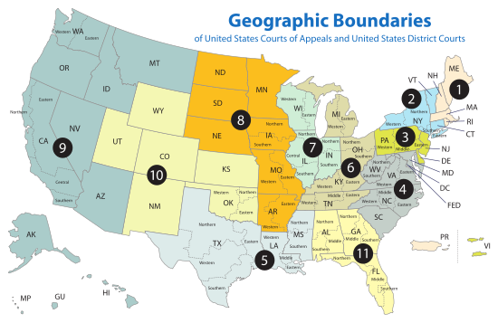
- First CircuitUnited States Court of Appeals for the First CircuitThe United States Court of Appeals for the First Circuit is a federal court with appellate jurisdiction over the district courts in the following districts:* District of Maine* District of Massachusetts...
- Second CircuitUnited States Court of Appeals for the Second CircuitThe United States Court of Appeals for the Second Circuit is one of the thirteen United States Courts of Appeals...
- Third CircuitUnited States Court of Appeals for the Third CircuitThe United States Court of Appeals for the Third Circuit is a federal court with appellate jurisdiction over the district courts for the following districts:* District of Delaware* District of New Jersey...
- Fourth CircuitUnited States Court of Appeals for the Fourth CircuitThe United States Court of Appeals for the Fourth Circuit is a federal court located in Richmond, Virginia, with appellate jurisdiction over the district courts in the following districts:*District of Maryland*Eastern District of North Carolina...
- Fifth CircuitUnited States Court of Appeals for the Fifth CircuitThe United States Court of Appeals for the Fifth Circuit is a federal court with appellate jurisdiction over the district courts in the following districts:* Eastern District of Louisiana* Middle District of Louisiana...
- Sixth CircuitUnited States Court of Appeals for the Sixth CircuitThe United States Court of Appeals for the Sixth Circuit is a federal court with appellate jurisdiction over the district courts in the following districts:* Eastern District of Kentucky* Western District of Kentucky...
- Seventh CircuitUnited States Court of Appeals for the Seventh CircuitThe United States Court of Appeals for the Seventh Circuit is a federal court with appellate jurisdiction over the courts in the following districts:* Central District of Illinois* Northern District of Illinois...
- Eighth CircuitUnited States Court of Appeals for the Eighth CircuitThe United States Court of Appeals for the Eighth Circuit is a federal court with appellate jurisdiction over the district courts in the following districts:* Eastern District of Arkansas* Western District of Arkansas...
- Ninth CircuitUnited States Court of Appeals for the Ninth CircuitThe United States Court of Appeals for the Ninth Circuit is a U.S. federal court with appellate jurisdiction over the district courts in the following districts:* District of Alaska* District of Arizona...
- Tenth CircuitUnited States Court of Appeals for the Tenth CircuitThe United States Court of Appeals for the Tenth Circuit is a federal court with appellate jurisdiction over the district courts in the following districts:* District of Colorado* District of Kansas...
- Eleventh CircuitUnited States Court of Appeals for the Eleventh CircuitThe United States Court of Appeals for the Eleventh Circuit is a federal court with appellate jurisdiction over the district courts in the following districts:* Middle District of Alabama...
- DC CircuitUnited States Court of Appeals for the District of Columbia CircuitThe United States Court of Appeals for the District of Columbia Circuit known informally as the D.C. Circuit, is the federal appellate court for the U.S. District Court for the District of Columbia. Appeals from the D.C. Circuit, as with all the U.S. Courts of Appeals, are heard on a...
- Federal CircuitUnited States Court of Appeals for the Federal Circuit-Vacancies and pending nominations:-List of former judges:-Chief judges:Notwithstanding the foregoing, when the court was initially created, Congress had to resolve which chief judge of the predecessor courts would become the first chief judge...
Unofficial U.S. multi-state regions
- AppalachiaAppalachiaAppalachia is a term used to describe a cultural region in the eastern United States that stretches from the Southern Tier of New York state to northern Alabama, Mississippi, and Georgia. While the Appalachian Mountains stretch from Belle Isle in Canada to Cheaha Mountain in the U.S...
- Ark-La-TexArk-La-TexThe Ark-La-Tex, Arklatex, or ArkLaTex is a U.S. socio-economic region where Arkansas, Louisiana, Texas, and Oklahoma intersect. Some prefer the more inclusive Arklatexoma...
- Atlantic SeaboardEast Coast of the United StatesThe East Coast of the United States, also known as the Eastern Seaboard, refers to the easternmost coastal states in the United States, which touch the Atlantic Ocean and stretch up to Canada. The term includes the U.S...
- Bible BeltBible BeltBible Belt is an informal term for a region in the southeastern and south-central United States in which socially conservative evangelical Protestantism is a significant part of the culture and Christian church attendance across the denominations is generally higher than the nation's average.The...
- Black Dirt RegionBlack Dirt RegionThe Black Dirt Region is located in southern Orange County, New York, USA and northern Sussex County, New Jersey. It is mostly located in the western section of the Town of Warwick, centered around the hamlet of Pine Island...
- Blackstone ValleyBlackstone ValleyThe Blackstone Valley or Blackstone River Valley is a region of Massachusetts and Rhode Island. It was a major contributor to the American Industrial Revolution...
- Border states:
- Civil War Border States
- International border statesInternational Border statesInternational border states are those states in a country that border another country. In the United States there are seventeen: thirteen on the US-Canada border and four on the US-Mexico border.US States bordering Canada :...
- The CarolinasThe CarolinasThe Carolinas is a term used in the United States to refer collectively to the states of North and South Carolina. Together, the two states + have a population of 13,942,126. "Carolina" would be the fifth most populous state behind California, Texas, New York, and Florida...
- CascadiaPacific NorthwestThe Pacific Northwest is a region in northwestern North America, bounded by the Pacific Ocean to the west and, loosely, by the Rocky Mountains on the east. Definitions of the region vary and there is no commonly agreed upon boundary, even among Pacific Northwesterners. A common concept of the...
- Central United StatesCentral United StatesThe Central United States is sometimes conceived as between the Eastern United States and Western United States as part of a three-region model, roughly coincident with the Midwestern United States plus the western and central portions of the Southern United States; the term is also sometimes used...
- Champlain ValleyChamplain ValleyThe Champlain Valley is a region of the United States around Lake Champlain in Vermont and New York extending slightly into Quebec, Canada as part of the St. Lawrence River drainage basin drained northward by the Richelieu River into the St...
- Coastal States
- Colorado PlateauColorado PlateauThe Colorado Plateau, also called the Colorado Plateau Province, is a physiographic region of the Intermontane Plateaus, roughly centered on the Four Corners region of the southwestern United States. The province covers an area of 337,000 km2 within western Colorado, northwestern New Mexico,...
- Contiguous United StatesContiguous United StatesThe contiguous United States are the 48 U.S. states on the continent of North America that are south of Canada and north of Mexico, plus the District of Columbia....
- Columbia BasinColumbia BasinThe Columbia Basin, the drainage basin of the Columbia River, occupies a large area–about —of the Pacific Northwest region of North America. In common usage, the term often refers to a smaller area, generally the portion of the drainage basin that lies within eastern Washington.Usage of the term...
- The DakotasThe DakotasThe Dakotas is a collective term that refers to the U.S. states of North Dakota and South Dakota together. The term has been used historically to describe the Dakota Territory, and is continued to be used to describe the collective heritage, culture, geography, fauna, sociology, the economy, and...
- Deep SouthDeep SouthThe Deep South is a descriptive category of the cultural and geographic subregions in the American South. Historically, it is differentiated from the "Upper South" as being the states which were most dependent on plantation type agriculture during the pre-Civil War period...
- Delaware ValleyDelaware ValleyThe Delaware Valley is a term used to refer to the valley where the Delaware River flows, along with the surrounding communities. This includes the metropolitan area centered on the city of Philadelphia. Such educational institutions as Delaware Valley Regional High School in Alexandria Township...
- Delmarva PeninsulaDelmarva PeninsulaThe Delmarva Peninsula is a large peninsula on the East Coast of the United States, occupied by most of Delaware and portions of Maryland and Virginia...
- DixieDixieDixie is a nickname for the Southern United States.- Origin of the name :According to the Oxford English Dictionary, the origins of this nickname remain obscure. According to A Dictionary of Americanisms on Historical Principles , by Mitford M...
- Driftless Area
- East CoastEast Coast of the United StatesThe East Coast of the United States, also known as the Eastern Seaboard, refers to the easternmost coastal states in the United States, which touch the Atlantic Ocean and stretch up to Canada. The term includes the U.S...
- Eastern United StatesEastern United StatesThe Eastern United States, the American East, or simply the East is traditionally defined as the states east of the Mississippi River. The first two tiers of states west of the Mississippi have traditionally been considered part of the West, but can be included in the East today; usually in...
- Four Corners
- Frontier StripFrontier StripThe Frontier Strip are the six states in the United States forming a north-south line from North Dakota to Texas. In the American Old West, westward from this strip was the frontier of the United States toward the latter part of the 19th century...
- Great American DesertGreat American DesertThe term Great American Desert was used in the 19th century to describe the western part of the Great Plains east of the Rocky Mountains in North America....
- Great BasinGreat BasinThe Great Basin is the largest area of contiguous endorheic watersheds in North America and is noted for its arid conditions and Basin and Range topography that varies from the North American low point at Badwater Basin to the highest point of the contiguous United States, less than away at the...
- Great Lakes RegionGreat Lakes region (North America)The Great Lakes region of North America, occasionally known as the Third Coast or the Fresh Coast , includes the eight U.S. states of Illinois, Indiana, Michigan, Minnesota, New York, Ohio, Pennsylvania and Wisconsin as well as the Canadian province of Ontario...
- Great North WoodsGreat North WoodsThe Great North Woods are spread across four northeastern U.S. states: Maine, New Hampshire, Vermont and New York and into the Canadian province of Quebec, from the Down East lakes to the Adirondack Mountains...
- Great PlainsGreat PlainsThe Great Plains are a broad expanse of flat land, much of it covered in prairie, steppe and grassland, which lies west of the Mississippi River and east of the Rocky Mountains in the United States and Canada. This area covers parts of the U.S...
- Great ValleyGreat Appalachian ValleyThe Great Valley, also called the Great Appalachian Valley or Great Valley Region, is one of the major landform features of eastern North America. It is a gigantic trough — a chain of valley lowlands — and the central feature of the Appalachian Mountain system...
- Gulf CoastGulf Coast of the United StatesThe Gulf Coast of the United States, sometimes referred to as the Gulf South, South Coast, or 3rd Coast, comprises the coasts of American states that are on the Gulf of Mexico, which includes Texas, Louisiana, Mississippi, Alabama, and Florida and are known as the Gulf States...
- Gulf South
- High PlainsHigh Plains (United States)The High Plains are a subregion of the Great Plains mostly in the Western United States, but also partly in the Midwest states of Nebraska, Kansas, and South Dakota, generally encompassing the western part of the Great Plains before the region reaches the Rocky Mountains...
- Inland Empire (Pacific Northwest)Inland Empire (Pacific Northwest)thumb|The Inland Empire regionThe Inland Northwest, or Inland Empire, is a region in the Pacific Northwest centered on Spokane, Washington, including the surrounding Columbia River basin and all of North Idaho....
- Interior PlainsInterior PlainsThe Interior Plains is a vast physiographic region that spreads across the Laurentian craton of central North America.-Geography:The Interior Plains are an extensive physiographic division encompassing 8 distinct physiographic provinces, the Interior Low Plateaus, Great Plains, Central Lowland,...
- Intermountain States
- Lake TahoeLake TahoeLake Tahoe is a large freshwater lake in the Sierra Nevada of the United States. At a surface elevation of , it is located along the border between California and Nevada, west of Carson City. Lake Tahoe is the largest alpine lake in North America. Its depth is , making it the USA's second-deepest...
- Llano EstacadoLlano EstacadoLlano Estacado , commonly known as the Staked Plains, is a region in the Southwestern United States that encompasses parts of eastern New Mexico and northwestern Texas, including the South Plains and parts of the Texas Panhandle...
- Mississippi DeltaMississippi DeltaThe Mississippi Delta is the distinctive northwest section of the U.S. state of Mississippi that lies between the Mississippi and Yazoo Rivers. The region has been called "The Most Southern Place on Earth" because of its unique racial, cultural, and economic history...
- Mississippi RiverMississippi RiverThe Mississippi River is the largest river system in North America. Flowing entirely in the United States, this river rises in western Minnesota and meanders slowly southwards for to the Mississippi River Delta at the Gulf of Mexico. With its many tributaries, the Mississippi's watershed drains...
- Mojave DesertMojave DesertThe Mojave Desert occupies a significant portion of southeastern California and smaller parts of central California, southern Nevada, southwestern Utah and northwestern Arizona, in the United States...
- Mountain StatesMountain Statesthumb|300px|Regional definitions vary from source to source. The states shown in dark red are always included, while the striped states are usually considered part of the same region called the Mountain States....
- Ohio Valley
- OzarksThe OzarksThe Ozarks are a physiographic and geologic highland region of the central United States. It covers much of the southern half of Missouri and an extensive portion of northwestern and north central Arkansas...
- Pacific StatesPacific StatesThe Pacific States form one of the nine geographic divisions within the United States that are officially recognized by that country's census bureau. There are five states in this division — Alaska, California, Hawaii, Oregon, Washington — and, as its name suggests, they all have...
- Pacific NorthwestPacific NorthwestThe Pacific Northwest is a region in northwestern North America, bounded by the Pacific Ocean to the west and, loosely, by the Rocky Mountains on the east. Definitions of the region vary and there is no commonly agreed upon boundary, even among Pacific Northwesterners. A common concept of the...
- PalousePalouseThe Palouse is a region of the northwestern United States, encompassing parts of southeastern Washington, north central Idaho and, in some definitions, extending south into northeast Oregon. It is a major agricultural area, primarily producing wheat and legumes...
- PiedmontPiedmont (United States)The Piedmont is a plateau region located in the eastern United States between the Atlantic Coastal Plain and the main Appalachian Mountains, stretching from New Jersey in the north to central Alabama in the south. The Piedmont province is a physiographic province of the larger Appalachian division...
- Piney WoodsPiney WoodsThe Piney Woods is a temperate coniferous forest terrestrial ecoregion in the Southern United States covering of East Texas, southern Arkansas, western Louisiana, and southeastern Oklahoma. These coniferous forests are dominated by several species of pine as well as hardwoods including hickory and...
- Rocky MountainsRocky MountainsThe Rocky Mountains are a major mountain range in western North America. The Rocky Mountains stretch more than from the northernmost part of British Columbia, in western Canada, to New Mexico, in the southwestern United States...
- Shawnee HillsShawnee HillsThe Shawnee Hills is a region of Southern Illinois that rests mainly in an east-west arc roughly following the outline of the southern end of the Illinois Basin. Whereas Mississippian and Pennsylvania Age rock layers are deep beneath the surface in central Illinois, these strata pierce the surface...
- Shenandoah ValleyShenandoah ValleyThe Shenandoah Valley is both a geographic valley and cultural region of western Virginia and West Virginia in the United States. The valley is bounded to the east by the Blue Ridge Mountains, to the west by the eastern front of the Ridge-and-Valley Appalachians , to the north by the Potomac River...
- SiouxlandSiouxlandSiouxland is a vernacular region that encompasses the entire Big Sioux River drainage basin in the U.S. states of South Dakota, Minnesota, Nebraska and Iowa....
- The SouthSouthern United StatesThe Southern United States—commonly referred to as the American South, Dixie, or simply the South—constitutes a large distinctive area in the southeastern and south-central United States...
- Southern Rocky MountainsSouthern Rocky MountainsThe Southern Rocky Mountains are a major subregion of the Rocky Mountains of North America located in the southern portion of the U.S. state of Wyoming, the central and western portions of Colorado, the northern portion of New Mexico, and extreme eastern portions of Utah...
- Southeastern United StatesSoutheastern United StatesThe Southeastern United States, colloquially referred to as the Southeast, is the eastern portion of the Southern United States. It is one of the most populous regions in the United States of America....
- SouthwestSouthwestern United StatesThe Southwestern United States is a region defined in different ways by different sources. Broad definitions include nearly a quarter of the United States, including Arizona, California, Colorado, Nevada, New Mexico, Oklahoma, Texas and Utah...
- Susquehanna RiverSusquehanna RiverThe Susquehanna River is a river located in the northeastern United States. At long, it is the longest river on the American east coast that drains into the Atlantic Ocean, and with its watershed it is the 16th largest river in the United States, and the longest river in the continental United...
- Tennessee ValleyTennessee ValleyThe Tennessee Valley is the drainage basin of the Tennessee River and is largely within the U.S. state of Tennessee. It stretches from southwest Kentucky to northwest Georgia and from northeast Mississippi to the mountains of Virginia and North Carolina...
- Trans-AppalachiaTrans-AppalachiaThe area west of the Appalachian Mountains is a region known as trans-Appalachia.-First US inhabitants of the trans-Appalachia region:In the early part of the 18th century Americans who wanted to find a better life in the wilderness traveled several main roads over the Appalachians. Those from New...
- Trans-MississippiTrans-MississippiThe Trans-Mississippi was the geographic area west of the Mississippi River during the 19th century, containing the states of Arkansas, Louisiana, Missouri and Texas, and the Indian Territory . The term was especially used by the Confederate States of America as the designation for the theater of...
- Twin TiersTwin TiersThe Twin Tiers is a geographical term that refers to the collective counties that lie on the New York-Pennsylvania border adjacent to the 42nd parallel north....
- Upland SouthUpland SouthThe terms Upper South and Upland South refer to the northern part of the Southern United States, in contrast to the Lower South or Deep South.-Geography:There is a slight difference in usage between the two terms...
- Upper MidwestUpper MidwestThe Upper Midwest is a region in the northern portion of the U.S. Census Bureau's Midwestern United States. It is largely a sub-region of the midwest. Although there are no uniformly agreed-upon boundaries, the region is most commonly used to refer to the states of Minnesota, Wisconsin, and...
- VirginiaVirginiaThe Commonwealth of Virginia , is a U.S. state on the Atlantic Coast of the Southern United States. Virginia is nicknamed the "Old Dominion" and sometimes the "Mother of Presidents" after the eight U.S. presidents born there...
s - WaxhawsWaxhawsThe Waxhaws is a geographical area on the border of North and South Carolina.-Geography:The Waxhaws region is in the Piedmont region of North and South Carolina, southwest of the Uwharrie Mountains. The region encompasses an area just south of Charlotte, North Carolina, to Lancaster, South...
- West CoastWest Coast of the United StatesWest Coast or Pacific Coast are terms for the westernmost coastal states of the United States. The term most often refers to the states of California, Oregon, and Washington. Although not part of the contiguous United States, Alaska and Hawaii do border the Pacific Ocean but can't be included in...
The Belts
- Bible BeltBible BeltBible Belt is an informal term for a region in the southeastern and south-central United States in which socially conservative evangelical Protestantism is a significant part of the culture and Christian church attendance across the denominations is generally higher than the nation's average.The...
- Black BeltBlack Belt (U.S. region)The Black Belt is a region of the Southern United States. Although the term originally described the prairies and dark soil of central Alabama and northeast Mississippi, it has long been used to describe a broad agricultural region in the American South characterized by a history of plantation...
- Cotton BeltCotton Belt (region)Cotton Belt is a term applied to a region of the southern United States where cotton was the predominant cash crop from the late 18th century into the 20th century....
- Grain Belt
- Rust BeltRust BeltThe Rust Belt is a term that gained currency in the 1980s as the informal description of an area straddling the Midwestern and Northeastern United States, in which local economies traditionally garnered an increased manufacturing sector to add jobs and corporate profits...
- SnowbeltSnowbeltSnowbelt is a term describing of a number of regions near the Great Lakes in North America where heavy snowfall in the form of lake-effect snow is particularly common. Snowbelts are typically found downwind of the lakes, principally off the eastern and southern shores...
- Sun BeltSun BeltThe Sun Belt or Spanish Belt is a region of the United States generally considered to stretch across the South and Southwest . Another rough boundary of the region is the area south of the 36th parallel, north latitude. It is the largest region which the U.S government does not recognize officially...
Interstate metropolitan areas
- Augusta-Aiken Metropolitan AreaCentral Savannah River AreaThe Central Savannah River Area is a 13-county region in the U.S. state of Georgia, and is also considered to include five to eight counties in South Carolina. The term was coined in 1950 by C.C. McCollum, the winner of a $250 contest held by The Augusta Chronicle to generate the best name for the...
- Baltimore-Washington Metropolitan AreaBaltimore-Washington Metropolitan AreaThe Baltimore-Washington Metropolitan Area is a combined statistical area consisting of the overlapping labor market region of the cities of Baltimore, Maryland and Washington, D.C.. The region includes Central Maryland, Northern Virginia, and Jefferson County in the Eastern Panhandle of West...
- Greater BostonGreater BostonGreater Boston is the area of the Commonwealth of Massachusetts surrounding the city of Boston. Due to ambiguity in usage, the size of the area referred to can be anywhere between that of the metropolitan statistical area of Boston and that of the city's combined statistical area which includes...
- Charlotte Metropolitan AreaCharlotte metropolitan areaThe Charlotte metropolitan area is a metropolitan area/region of North and South Carolina within and surrounding the city of Charlotte...
- Chattanooga Metropolitan AreaChattanooga, TennesseeChattanooga is the fourth-largest city in the US state of Tennessee , with a population of 169,887. It is the seat of Hamilton County...
- Chicago metropolitan area
- Cincinnati-Northern Kentucky metropolitan area
- Delaware ValleyDelaware ValleyThe Delaware Valley is a term used to refer to the valley where the Delaware River flows, along with the surrounding communities. This includes the metropolitan area centered on the city of Philadelphia. Such educational institutions as Delaware Valley Regional High School in Alexandria Township...
- Evansville Metropolitan AreaEvansville, IN-KY Metropolitan Statistical AreaThe Evansville, IN-KY Metropolitan Statistical Area is the 142nd largest Metropolitan Statistical Area in the United States. The primary city is Evansville, Indiana. Other Indiana cities include Boonville, Mount Vernon, Oakland City, and Princeton...
- Fargo-Moorhead metropolitan area
- Fort Smith metropolitan areaFort Smith metropolitan areaThe Fort Smith Metropolitan Statistical Area, as defined by the United States Census Bureau, is a five-county area including three Arkansas counties and two Oklahoma counties, and anchored by the city of Fort Smith, Arkansas...
- Front Range Urban CorridorFront Range Urban CorridorThe Front Range Urban Corridor is an oblong region of urban population located along the eastern face of the Southern Rocky Mountains in the U.S. states of Colorado and Wyoming. The corridor derives its name from the Front Range, the mountain range that defines the west central boundary of the...
- Greater Grand ForksGreater Grand ForksAccording to the 2006–2008 American Community Survey, the population of the Greater Grand Forks metro area was 97,260, of which 50.9% were male and 49.1% were female.-Age:* Under 5 years: 6.3%* 5–9 years: 5.5%* 10–14 years: 6.1%* 15–19 years: 9.6%...
- Kansas City Metropolitan AreaKansas City Metropolitan AreaThe Kansas City Metropolitan Area is a fifteen-county metropolitan area that is anchored by Kansas City, Missouri and is bisected by the border between the states of Missouri and Kansas. As of the 2010 Census, the metropolitan area has a population of 2,035,334. The metropolitan area is the...
- Louisville Metropolitan AreaLouisville metropolitan areaThe Louisville-Jefferson County, KY-IN Metropolitan Statistical Area, commonly called the Louisville metropolitan area or Kentuckiana, is the 42nd largest Metropolitan Statistical Area in the United States...
(often locally known as Kentuckiana) - Memphis Metropolitan AreaMemphis Metropolitan AreaThe Memphis Metropolitan Statistical Area, TN-MS-AR , more commonly known as The Mid-South, is the 41st largest among similarly designated areas in the United States. The metropolitan area covers eight counties in three states – Tennessee, Mississippi, and Arkansas...
- MichianaMichianaMichiana is a region in northern Indiana and southwestern Michigan centered on the city of South Bend, Indiana. The Chamber of Commerce of St. Joseph County, Indiana defines Michiana as "counties that contribute at least 500 inbound commuting workers to St. Joseph County daily." Those counties...
- Minneapolis – Saint Paul (also commonly known as the Twin Cities)
- New York Metropolitan AreaNew York metropolitan areaThe New York metropolitan area, also known as Greater New York, or the Tri-State area, is the region that composes of New York City and the surrounding region...
, the Tri-State Region - Omaha-Council Bluffs Metropolitan AreaOmaha-Council Bluffs metropolitan areaThe Omaha-Council Bluffs metropolitan area is a metropolitan area comprising the cities of Omaha, Nebraska, Council Bluffs, Iowa, and surrounding areas. The Omaha-Council Bluffs metropolitan area has a population of 865,350 . The metropolitan area, as defined by the Office of Management and Budget,...
- Portland Metropolitan AreaPortland metropolitan areaThe Portland-Vancouver-Hillsboro, OR-WA Metropolitan Statistical Area , also known as the Portland metropolitan area or Greater Portland, is an urban area in the U.S. states of Oregon and Washington centered around the city of Portland, Oregon. The U.S...
- Quad CitiesQuad CitiesThe Quad Cities is a group of five cities straddling the Mississippi River on the Iowa–Illinois boundary. These cities, Davenport and Bettendorf and Rock Island, Moline, and East Moline , are the center of the Quad Cities Metropolitan Area, which, as of 2010, had an estimated population of...
- Sacramento Metropolitan AreaSacramento metropolitan areaThe Greater Sacramento area, or officially Sacramento–Arden Arcade–Yuba City, CA-NV Combined Statistical Area, is a combined statistical area consisting of several metropolitan statistical areas and seven counties in Northern California and one in Western Nevada. These are Sacramento, Yolo, El...
- Greater St. Louis
- Texarkana metropolitan areaTexarkana metropolitan areaThe Texarkana, TX-Texarkana, AR Metropolitan Statistical Area , as defined by the United States Office of Management and Budget, is a two-county region anchored by the twin cities of Texarkana, Texas and Texarkana, Arkansas, and encompassing the surrounding communities in Bowie County, Texas and...
- Tri-Cities (Tennessee-Virginia)Tri-Cities, TennesseeIn Tennessee and Virginia the name "Tri-Cities" refers to the region comprising the cities of Kingsport, Johnson City and Bristol and the surrounding smaller towns and communities in Northeast Tennessee and Southwest Virginia...
- Twin PortsTwin PortsThe Twin Ports of Duluth, Minnesota and Superior, Wisconsin are located at the western part of Lake Superior and together are considered the largest freshwater port in the world. They are twin cities and seaports, connected to the Atlantic Ocean through the Great Lakes and the St. Lawrence...
(Duluth, MinnesotaDuluth, MinnesotaDuluth is a port city in the U.S. state of Minnesota and is the county seat of Saint Louis County. The fourth largest city in Minnesota, Duluth had a total population of 86,265 in the 2010 census. Duluth is also the second largest city that is located on Lake Superior after Thunder Bay, Ontario,...
-Superior, WisconsinSuperior, WisconsinSuperior is a city in and the county seat of Douglas County, Wisconsin, United States. The population was 26,960 at the 2010 census. Located at the junction of U.S. Highways 2 and 53, it is north of and adjacent to both the Village of Superior and the Town of Superior.Superior is at the western...
) - Virginia Beach-Norfolk-Newport News (Hampton Roads)Hampton RoadsHampton Roads is the name for both a body of water and the Norfolk–Virginia Beach metropolitan area which surrounds it in southeastern Virginia, United States...
- Washington Metropolitan AreaWashington Metropolitan AreaThe Washington Metropolitan Area is the metropolitan area centered on Washington, D.C., the capital of the United States. The area includes all of the federal district and parts of the U.S...
- Youngstown-Warren-Boardman, OH-PA Metropolitan AreaYoungstown-Warren-Boardman, OH-PA Metropolitan AreaThe Youngstown Metropolitan Area is a metropolitan area centered on the American city of Youngstown, Ohio. According to the US Census Bureau, the metropolitan area includes Mahoning and Trumbull counties in Ohio and Mercer county in Pennsylvania...
Interstate megalopolises
(Megapolitan area, MegalopolisMegalopolis (city type)
A megalopolis is typically defined as a chain of roughly adjacent metropolitan areas. The term was used by Oswald Spengler in his 1918 book, The Decline of the West, and Lewis Mumford in his 1938 book, The Culture of Cities, which described it as the first stage in urban overdevelopment and...
)
- Piedmont Atlantic MegaRegionPiedmont Atlantic MegaRegionThe Piedmont Atlantic Megaregion is the name given to an area of the Southeastern United States that includes the Atlanta, Charlotte, Nashville, Birmingham, Upstate South Carolina, Piedmont Triad, and Raleigh-Durham metropolitan areas. The megaregion generally follows the Interstate 85/20 corridor...
(PAM) - Northeast megalopolisNortheast megalopolisThe Northeast megalopolis or Boston–Washington megalopolis is the heavily urbanized area of the United States stretching from the the northern suburbs of Boston, Massachusetts to the southern suburbs of Washington, D.C. On a map, the region appears almost as a perfectly straight line. As of 2000,...
- Cascadia
- Great Lakes
- California
- Arizona Sun CorridorArizona Sun CorridorThe Arizona Sun Corridor, shortened Sun Corridor, is a megaregion, or megapolitan area, in the southern area of the U.S. state of Arizona. The Sun Corridor is equivalent to Indiana in size and population; unlike Indiana, it will add another Indiana's worth of residents by 2040...
Alabama
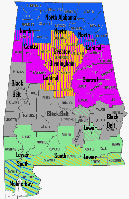
- Greater Birmingham
- Black BeltBlack Belt (region of Alabama)The Black Belt is a region of the U.S. state of Alabama, and part of the larger Black Belt Region of the Southern United States, which stretches from Texas to Maryland. The term originally referred to the region underlain by a thin layer of rich, black topsoil developed atop the chalk of the Selma...
- Central AlabamaCentral AlabamaCentral Alabama is the region in the state of Alabama that stretches approximately 170 miles from the western border with Mississippi to eastern border with Georgia and 136 miles from the northern border of Cullman County to the Alabama River in southern Autauga County. With a...
- Alabama Gulf Coast
- Lower AlabamaLower AlabamaLower Alabama is a term used to describe various parts of southern Alabama. Its usage does not however reflect a formally defined geographic region. Three areas generally are known to use the Lower Alabama name....
- Mobile BayMobile BayMobile Bay is an inlet of the Gulf of Mexico, lying within the state of Alabama in the United States. Its mouth is formed by the Fort Morgan Peninsula on the eastern side and Dauphin Island, a barrier island on the western side. The Mobile River and Tensaw River empty into the northern end of the...
- North AlabamaNorth AlabamaNorth Alabama is a region of the U.S. state of Alabama, generally considered to include 12 counties: Cherokee, Colbert, DeKalb, Franklin, Jackson, Lauderdale, Lawrence, Limestone, Madison, Marshall, Morgan, and Winston, with a combined population of 958,247, or 20.84% of the state's population as...
- Northeast AlabamaNortheast AlabamaNortheast Alabama includes the cities of Anniston, Gadsden, Talladega, and their surrounding areas in the state of Alabama. The county inclusion varies, usually only consisting of the Anniston-Oxford Metropolitan Area and Gadsden Metropolitan Statistical Area...
- Northwest AlabamaNorthwest AlabamaNorthwest Alabama is a subdivision of the North Alabama region, and includes the cities of Decatur, Florence, Russellvile, and their surrounding areas in the state of Alabama. The county inclusion varies, usually only consisting of the Decatur Metropolitan Area and Florence-Muscle Shoals...
- South AlabamaSouth AlabamaSouth Alabama is a term used to describe various parts of southern Alabama. Its usage does not however reflect a strictly defined geographic region...
Alaska
- Arctic AlaskaArctic AlaskaArctic Alaska or Far North Alaska is a region of the U.S. state of Alaska generally referring to the northern areas on or close to the Arctic Ocean....
- The Bush
- Alaska InteriorAlaska InteriorThe Alaska Interior covers most of the U.S. state's territory. It is largely wilderness. Mountains include Mount McKinley in the Alaska Range, the Wrangell Mountains, and the Ray Mountains....
- Alaska North SlopeAlaska North SlopeThe Alaska North Slope is the region of the U.S. state of Alaska located on the northern slope of the Brooks Range along the coast of two marginal seas of the Arctic Ocean, the Chukchi Sea being on the western side of Point Barrow, and the Beaufort Sea on the eastern.The region contains the...
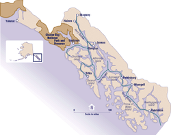
- Alaska Panhandle
- Aleutian Islands
- Kenai PeninsulaKenai PeninsulaThe Kenai Peninsula is a large peninsula jutting from the southern coast of Alaska in the United States. The name Kenai is probably derived from Kenayskaya, the Russian name for Cook Inlet, which borders the peninsula to the west.-Geography:...
- Seward PeninsulaSeward PeninsulaThe Seward Peninsula is a large peninsula on the western coast of the U.S. state of Alaska. It projects about into the Bering Sea between Norton Sound, the Bering Strait, the Chukchi Sea, and Kotzebue Sound, just below the Arctic Circle...
- Southcentral Alaska
- Southwest AlaskaSouthwest AlaskaSouthwest Alaska is a region of the U.S. state of Alaska. The area is not exactly defined by any governmental administrative region; nor does it always have a clear geographic boundary.-Geography:...
- Tanana ValleyTanana ValleyThe Tanana Valley is a lowland region in central Alaska in the United States, on the north side of the Alaska Range where the Tanana River emerges from the mountains.-Climate:...
- Yukon-Kuskokwim DeltaYukon-Kuskokwim DeltaThe Yukon–Kuskokwim Delta is one of the largest river deltas in the world, roughly the size of Oregon. It is located where the Yukon and Kuskokwim rivers empty into the Bering Sea on the west coast of the U.S. state of Alaska. The delta, which mostly consists of tundra, is protected as part of the...
- Mat‑Su ValleyMatanuska-Susitna ValleyMatanuska-Susitna Valley is an area in Southcentral Alaska south of the Alaska Range about 35 miles north of Anchorage, Alaska....
Arizona
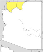
- Arizona StripArizona StripThe Arizona Strip is the part of the U.S. state of Arizona lying north of the Colorado River. The difficulty of crossing the Grand Canyon causes this region to have more natural connections with southern Utah and Nevada than with the rest of Arizona....
- Grand CanyonGrand CanyonThe Grand Canyon is a steep-sided canyon carved by the Colorado River in the United States in the state of Arizona. It is largely contained within the Grand Canyon National Park, the 15th national park in the United States...
- North Central ArizonaNorth Central ArizonaNorth Central Arizona is a geographical region of Arizona. It is in the Transition Zone between the Basin and Range province and the Colorado Plateau, and has some of the most rugged and scenic landscapes in Arizona....
- Northeast ArizonaNortheast ArizonaNortheast Arizona is a region of the U.S. state of Arizona commonly including Apache County and Navajo County. Some notable towns there are St. Johns, Eagar, Holbrook, Show Low, Winslow, Window Rock, Fort Defiance, Ganado, Chinle, and Kayenta....
- Northern ArizonaNorthern ArizonaNorthern Arizona is an unofficial, colloquially-defined region of the U.S. state of Arizona. It is dominated by the Colorado Plateau, the southern border of which in Arizona is called the Mogollon Rim. In the West lies the Grand Canyon, which was cut by the flow of the Colorado River while the...
- Phoenix metropolitan areaPhoenix Metropolitan AreaThe Phoenix metropolitan area, often referred to as The Valley of the Sun, is a metropolitan area, centered on the city of Phoenix, that includes much of the central part of the US state of Arizona...
- Southern ArizonaSouthern ArizonaSouthern Arizona is a region of the United States comprising the southernmost portion of the State of Arizona. It sometimes goes by the name Baja Arizona, which means "Lower Arizona" in Spanish.- Geography :...
Arkansas
- Northern Arkansas
- Crowley's RidgeCrowley's RidgeCrowley's Ridge is an unusual geological formation that rises 250 to above the alluvial plain of the Mississippi embayment in a line from southeastern Missouri to the Mississippi River near Helena, Arkansas. It is the most prominent feature in the Mississippi Alluvial Plain between Cape...
- the Delta
- Northwest Arkansas
- Central Arkansas
- the River Valley
- Southern Arkansas
California
- Northern CaliforniaNorthern CaliforniaNorthern California is the northern portion of the U.S. state of California. The San Francisco Bay Area , and Sacramento as well as its metropolitan area are the main population centers...
- Central CaliforniaCentral CaliforniaCentral California, sometimes referenced as Mid-State, is an area of California south of the San Francisco Bay Area and north of Southern California...
- Central Coast (North)Central Coast of CaliforniaThe Central Coast is an area of California, United States, roughly spanning the area between the Monterey Bay and Point Conception. It extends through Santa Cruz County, San Benito County, Monterey County, San Luis Obispo County, and Santa Barbara County...
- Big SurBig SurBig Sur is a sparsely populated region of the Central Coast of California where the Santa Lucia Mountains rise abruptly from the Pacific Ocean. The name "Big Sur" is derived from the original Spanish-language "el sur grande", meaning "the big south", or from "el país grande del sur", "the big...
- Monterey Bay AreaMonterey BayMonterey Bay is a bay of the Pacific Ocean, along the central coast of California. The bay is south of San Francisco and San Jose, between the cities of Santa Cruz and Monterey....
- Salinas ValleySalinas ValleyThe Salinas Valley lies south of San Francisco, California.The word "salina" is spanish for salt marsh, salt lake or salt pan.-Geography:The Salinas Valley runs approximately south-east from Salinas towards King City. The valley lends its name to the geologic province in which it's located, the...
- Santa Cruz MountainsSanta Cruz MountainsThe Santa Cruz Mountains, part of the Pacific Coast Ranges, are a mountain range in central California, United States. They form a ridge along the San Francisco Peninsula, south of San Francisco, separating the Pacific Ocean from San Francisco Bay and the Santa Clara Valley, and continuing south,...
- Big Sur
- Central Coast (North)
- Central Valley (North)
- Sacramento ValleySacramento ValleyThe Sacramento Valley is the portion of the California Central Valley that lies to the north of the San Joaquin-Sacramento Delta in the U.S. state of California. It encompasses all or parts of ten counties.-Geography:...
- Chico AreaChico, CaliforniaChico is the most populous city in Butte County, California, United States. The population was 86,187 at the 2010 census, up from 59,954 at the time of the 2000 census...
- Greater SacramentoSacramento metropolitan areaThe Greater Sacramento area, or officially Sacramento–Arden Arcade–Yuba City, CA-NV Combined Statistical Area, is a combined statistical area consisting of several metropolitan statistical areas and seven counties in Northern California and one in Western Nevada. These are Sacramento, Yolo, El...
- Yuba-Sutter AreaYuba-Sutter AreaThe Yuba-Sutter Area is a smaller metropolitan community including Yuba and Sutter Counties in Northern California's Central Valley within the Greater Sacramento area. The official name given by the U.S...
- Sutter ButtesSutter ButtesThe Sutter Buttes are a small circular complex of eroded volcanic lava domes which rise as buttes above the flat plains of the Central Valley of California in the United States. The highest peak, South Butte, reaches about above sea level. The Buttes are located just outside of Yuba City,...
- Sutter Buttes
- Chico Area
- Sacramento-San Joaquin River Delta
- San Joaquin Valley (North)San Joaquin ValleyThe San Joaquin Valley is the area of the Central Valley of California that lies south of the Sacramento – San Joaquin River Delta in Stockton...
- Metropolitan FresnoMetropolitan FresnoMetropolitan Fresno or officially Fresno-Madera, CA CSA is a metropolitan area in California's Central Valley consisting of Fresno and Madera counties in the southern area of Northern California...
- Merced AreaMerced, CaliforniaMerced is a city in, and the county seat of, Merced County, California in the San Joaquin Valley of Northern California. As of the 2010 census, the city had a population of 78,958. Incorporated in 1889, Merced is a charter city that operates under a council-manager government...
- Modesto AreaModesto, CaliforniaModesto is a city in, and is the county seat of, Stanislaus County, California. With a population of approximately 201,165 at the 2010 census, Modesto ranks as the 18th largest city in the state of California....
- Stockton AreaStockton, CaliforniaStockton, California, the seat of San Joaquin County, is the fourth-largest city in the Central Valley of the U.S. state of California. With a population of 291,707 at the 2010 census, Stockton ranks as this state's 13th largest city...
- Metropolitan Fresno
- Sacramento Valley
- San Francisco Bay AreaSan Francisco Bay AreaThe San Francisco Bay Area, commonly known as the Bay Area, is a populated region that surrounds the San Francisco and San Pablo estuaries in Northern California. The region encompasses metropolitan areas of San Francisco, Oakland, and San Jose, along with smaller urban and rural areas...
- East BayEast Bay (San Francisco Bay Area)The East Bay is a commonly used, informal term for the lands on the eastern side of the San Francisco Bay, in the San Francisco Bay Area, in California, United States...
- Oakland–Alameda CountyOakland, CaliforniaOakland is a major West Coast port city on San Francisco Bay in the U.S. state of California. It is the eighth-largest city in the state with a 2010 population of 390,724...
- Tri-Valley AreaTri-ValleyTri-Valley is a triangle-shaped region in the eastern San Francisco Bay Area. The area is 18 miles southeast of Oakland and 33 miles from San Francisco...
- Amador Valley
- Livermore Valley
- San Ramon ValleySan Ramon ValleyThe San Ramon Valley is a region in Contra Costa County and Alameda County, California, east of Oakland. The cities of San Ramon, Danville and Alamo as well as the southern edge of Walnut Creek are located in the valley. Interstate 680 serves as the primary transportation route for the...
- Oakland–Alameda County
- North BayNorth Bay (San Francisco Bay Area)The North Bay is a subregion of the San Francisco Bay Area, in California, United States. The largest city is Santa Rosa. It is by far the least populous and least urbanized part of the Bay Area...
- Marin CountyMarin County, CaliforniaMarin County is a county located in the North San Francisco Bay Area of the U.S. state of California, across the Golden Gate Bridge from San Francisco. As of 2010, the population was 252,409. The county seat is San Rafael and the largest employer is the county government. Marin County is well...
- Wine Country
- Napa ValleyNapa County, CaliforniaNapa County is a county located north of the San Francisco Bay Area in the U.S. state of California. It is coterminous with the Napa, California, Metropolitan Statistical Area. As of 2010 the population is 136,484. The county seat is Napa....
- Russian River ValleyRussian River (California)The Russian River, a southward-flowing river, drains of Sonoma and Mendocino counties in Northern California. With an annual average discharge of approximately , it is the second largest river flowing through the nine county Greater San Francisco Bay Area with a mainstem 110 miles ...
- Sonoma ValleySonoma ValleySonoma Valley is the birthplace of the California wine industry and often called The Valley of the Moon. Sonoma Valley is home to some of the earliest vineyards and wineries in the state, some of which survived the phylloxera epidemic of the 1870s and the impact of Prohibition...
- Napa Valley
- Telecom ValleyTelecom ValleyTelecom Valley was an area located in Sonoma County, California specifically the Redwood Business Park of Petaluma, California.-History:...
- Marin County
- The PeninsulaSan Francisco PeninsulaThe San Francisco Peninsula is a peninsula in the San Francisco Bay Area that separates the San Francisco Bay from the Pacific Ocean. On its northern tip is the City and County of San Francisco. Its southern base is in Santa Clara County, including the cities of Palo Alto, Los Altos, and Mountain...
- City and County of San Francisco
- San Mateo CountySan Mateo County, CaliforniaSan Mateo County is a county located in the San Francisco Bay Area of the U.S. state of California. It covers most of the San Francisco Peninsula just south of San Francisco, and north of Santa Clara County. San Francisco International Airport is located at the northern end of the county, and...
- South Bay
- Santa Clara ValleySanta Clara ValleyThe Santa Clara Valley is a valley just south of the San Francisco Bay in Northern California in the United States. Much of Santa Clara County and its county seat, San José, are in the Santa Clara Valley. The valley was originally known as the Valley of Heart’s Delight for its high concentration...
- San JoseSan Jose, CaliforniaSan Jose is the third-largest city in California, the tenth-largest in the U.S., and the county seat of Santa Clara County which is located at the southern end of San Francisco Bay...
–Santa Clara CountySanta Clara County, CaliforniaSanta Clara County is a county located at the southern end of the San Francisco Bay Area in the U.S. state of California. As of 2010 it had a population of 1,781,642. The county seat is San Jose. The highly urbanized Santa Clara Valley within Santa Clara County is also known as Silicon Valley... - Silicon ValleySilicon ValleySilicon Valley is a term which refers to the southern part of the San Francisco Bay Area in Northern California in the United States. The region is home to many of the world's largest technology corporations...
- San Jose
- Santa Clara Valley
- East Bay
- Sierra Nevada
- Gold CountryGold CountryGold Country is a region in the central and northeastern part of California, United States. It is famed for the mineral deposits and gold mines that attracted waves of immigrants, known as the 49ers, during the 1849 California Gold Rush.-Geography:State Route 49 was built through the Gold Country,...
- Lake TahoeLake TahoeLake Tahoe is a large freshwater lake in the Sierra Nevada of the United States. At a surface elevation of , it is located along the border between California and Nevada, west of Carson City. Lake Tahoe is the largest alpine lake in North America. Its depth is , making it the USA's second-deepest...
- YosemiteYosemite National ParkYosemite National Park is a United States National Park spanning eastern portions of Tuolumne, Mariposa and Madera counties in east central California, United States. The park covers an area of and reaches across the western slopes of the Sierra Nevada mountain chain...
- Gold Country
- Upstate CaliforniaUpstate CaliforniaUpstate California is a region of California consisting of its northernmost 20 counties, most of which are rural. Generally, this area consists of all territory within California north of the San Francisco Bay and Sacramento areas....
- North Coast
- Emerald TriangleEmerald TriangleThe Emerald Triangle refers to a region in Northern California so named because it is the largest region in The United States that produces illegal cannabis. Mendocino County, Humboldt County, and Trinity County are the three counties in Northern California that make up this region...
- Lost CoastLost CoastThe Lost Coast is a mostly undeveloped section of the California North Coast in Mendocino and Humboldt Counties, which includes the King Range. It was named the "Lost Coast" after the area experienced depopulation in the 1930s...
- Lost Coast
- Klamath MountainsKlamath MountainsThe Klamath Mountains, which include the Siskiyou, Marble, Scott, Trinity, Trinity Alps, Salmon, and northern Yolla-Bolly Mountains, are a rugged lightly populated mountain range in northwest California and southwest Oregon in the United States...
- Mendocino MountainsMendocino RangeThe Mendocino Range is one of several coastal mountain ranges which compose the Pacific Coast Range. This massive range of coastal mountains was formed during a period of coastal orogeny, millions of years ago. The Mendocino Range is a component of the California Coast Ranges of California...
- Emerald Triangle
- Shasta CascadeShasta CascadeThe Shasta Cascade region of California is located in the northeastern and north-central sections of the state bordering Oregon and Nevada, including far northern parts of the Central Valley and the Sierra Nevada mountain range. The area is centered on Mount Shasta in the California Cascade Range,...
- Mount ShastaMount ShastaMount Shasta is located at the southern end of the Cascade Range in Siskiyou County, California and at is the second highest peak in the Cascades and the fifth highest in California...
- Redding AreaRedding, CaliforniaRedding is a city in far-Northern California. It is the county seat of Shasta County, California, USA. With a population of 89,861, according to the 2010 Census...
- Trinity AlpsTrinity AlpsThe Trinity Alps are mountains in Northern California, in the Pacific Coast Ranges physiographic region, located to the northwest of Redding. Elevations there range from to at Thompson Peak. The Trinity Alps Wilderness covers , making it the second largest wilderness area in California...
- Mount Shasta
- Tricorner Region/Surprise Valley
- Modoc PlateauModoc PlateauThe Modoc Plateau lies in the northeast corner of California as well as parts of Oregon and Nevada. It is a mile-high expanse of lava flows with cinder cones, juniper flats, pine forests, and seasonal lakes. The plateau is thought to have been formed approximately 25 million years ago...
- Warner MountainsWarner MountainsThe Warner Mountains are an 85-mile-long mountain range running north-south through northeastern California and extending into southern Oregon in the United States...
- Modoc Plateau
- North Coast
- Central California
- Southern CaliforniaSouthern CaliforniaSouthern California is a megaregion, or megapolitan area, in the southern area of the U.S. state of California. Large urban areas include Greater Los Angeles and Greater San Diego. The urban area stretches along the coast from Ventura through the Southland and Inland Empire to San Diego...
- Central Coast (South) /Tri-CountiesCentral Coast of CaliforniaThe Central Coast is an area of California, United States, roughly spanning the area between the Monterey Bay and Point Conception. It extends through Santa Cruz County, San Benito County, Monterey County, San Luis Obispo County, and Santa Barbara County...
- San Luis Obispo AreaSan Luis Obispo, CaliforniaSan Luis Obispo is a city in California, located roughly midway between San Francisco and Los Angeles on the Central Coast. Founded in 1772 by Spanish Fr. Junipero Serra, San Luis Obispo is one of California’s oldest communities...
- Five CitiesFive CitiesFive Cities is a 2010 Turkish drama film, written, produced and directed by Onur Ünlü, about a young policeman just arrived in Istanbul who falls in love with a woman in a candy shop...
- Five Cities
- Santa Barbara AreaSanta Barbara, CaliforniaSanta Barbara is the county seat of Santa Barbara County, California, United States. Situated on an east-west trending section of coastline, the longest such section on the West Coast of the United States, the city lies between the steeply-rising Santa Ynez Mountains and the Pacific Ocean...
- Ventura AreaVentura, CaliforniaVentura is the county seat of Ventura County, California, United States, incorporated in 1866. The population was 106,433 at the 2010 census, up from 100,916 at the 2000 census. Ventura is accessible via U.S...
- Oxnard PlainOxnard PlainThe Oxnard Plain is a large coastal plain in southwest Ventura County, California bounded by the Santa Monica Mountains, the Santa Susana Mountains, and Oak Ridge to the east, the Topatopa Mountains to the north, the Santa Clara River Valley to the northeast and the Pacific Ocean to the south and...
- Oxnard Plain
- San Luis Obispo Area
- Central Valley (South)
- San Joaquin Valley (South)San Joaquin ValleyThe San Joaquin Valley is the area of the Central Valley of California that lies south of the Sacramento – San Joaquin River Delta in Stockton...
- Bakersfield AreaBakersfield, CaliforniaBakersfield is a city near the southern end of the San Joaquin Valley in Kern County, California. It is roughly equidistant between Fresno and Los Angeles, to the north and south respectively....
- Visalia Area
- Bakersfield Area
- San Joaquin Valley (South)
- Channel IslandsChannel Islands of CaliforniaThe Channel Islands of California are a chain of eight islands located in the Pacific Ocean off the coast of Southern California along the Santa Barbara Channel in the United States of America...
- South Coast
- Greater Los AngelesGreater Los Angeles AreaThe Greater Los Angeles Area, or the Southland, is a term used for the Combined Statistical Area sprawled over five counties in the southern part of California, namely Los Angeles County, Orange County, San Bernardino County, Riverside County and Ventura County...
- Los Angeles BasinLos Angeles BasinThe Los Angeles Basin is the coastal sediment-filled plain located between the Peninsular and Transverse ranges in southern California in the United States containing the central part of the city of Los Angeles as well as its southern and southeastern suburbs...
-
- Gateway CitiesGateway CitiesThe Gateway Cities of Southern California are those located in southeastern Los Angeles County. There is some cross-over between these cities and those composing South Los Angeles, East Los Angeles, the South Bay, and the San Gabriel Valley...
- Los Angeles CityLos ÁngelesLos Ángeles is the capital of the province of Biobío, in the commune of the same name, in Region VIII , in the center-south of Chile. It is located between the Laja and Biobío rivers. The population is 123,445 inhabitants...
- East Los AngelesEast Los Angeles (region)East Los Angeles is the portion of the City of Los Angeles that lies east of Downtown Los Angeles, the Los Angeles River and the unincorporated areas of Lincoln Heights, west of the San Gabriel Valley, East Los Angeles and City Terrace, south of Cypress Park, and north of Vernon, California and...
- Harbor AreaHarbor AreaThe Harbor Area is the area along the Port of Los Angeles. It contains neighborhoods of Los Angeles .-Standalone cities in the Harbor Area:*Carson*Long Beach-Los Angeles city neighborhoods in the Harbor Area:...
- South Los AngelesSouth Los AngelesSouth Los Angeles, often abbreviated as South L.A. and formerly South Central Los Angeles, is the official name for a large geographic and cultural portion lying to the southwest and southeast of downtown Los Angeles, California. The area was formerly called South Central, and is still widely known...
- Westside
- East Los Angeles
- Palos Verdes PeninsulaPalos VerdesPalos Verdes is a name often used to refer to a group of coastal cities in the Palos Verdes Hills on the Palos Verdes Peninsula, within southwestern Los Angeles County in the U.S...
- Gateway Cities
- South BaySouth Bay, Los AngelesThe South Bay is a region of the southwest peninsula of Los Angeles County, California, United States. The name stems from its geographic features stretching along the southern shores of Santa Monica Bay which forms its western border.The picture at right uses the broadest definition of the...
- Beach CitiesBeach CitiesThe term Beach Cities refers to both a region of California located in Los Angeles County along the Santa Monica Bay coastline as well as a smaller group of cities located therein the region...
- Beach Cities
- Conejo ValleyConejo ValleyThe Conejo Valley is a region spanning both southeastern Ventura County and northwestern Los Angeles County in Southern California, United States...
- San Gabriel ValleySan Gabriel ValleyThe San Gabriel Valley is one of the principal valleys of Southern California, United States. It lies to the east of Los Angeles, to the north of the Puente Hills, to the south of the San Gabriel Mountains, and west of the Inland Empire. It derives its name from the San Gabriel River that flows...
-
- Crescenta ValleyCrescenta ValleyThe Crescenta Valley is a small inland valley in Los Angeles County, California lying between the San Gabriel Mountains on the northeast and the Verdugo Mountains and San Rafael Hills on the southwest. It opens into the San Fernando Valley at the northwest and the San Gabriel Valley at the southeast...
- Peninsular Ranges (North)Peninsular RangesThe Peninsular Ranges are a group of mountain ranges, in the Pacific Coast Ranges, which stretch from southern California in the United States to the southern tip of Mexico's Baja California peninsula; they are part of the North American Coast Ranges that run along the Pacific coast from Alaska...
- San Jacinto MountainsSan Jacinto MountainsThe San Jacinto Mountains are a mountain range east of Los Angeles in southern California in the United States. The mountains are named for Saint Hyacinth . The Pacific Crest Trail runs along the spine of the range.The range extends for approximately from the San Bernardino Mountains southeast to...
- Santa Rosa MountainsSanta Rosa Mountains (California)The Santa Rosa Mountains are a short mountain range in the Peninsular Ranges system, located east of the Los Angeles Basin and northeast of the San Diego metropolitan area of southern California, in the Southwestern United States.-Geography:...
- San Jacinto Mountains
- Pomona ValleyPomona ValleyThe Pomona Valley, located between the San Gabriel Valley and Cucamonga Valley in Southern California, straddles the border between Los Angeles County and San Bernardino County. Back on March 1, 1893 the California Assembly voted 54-14 for a new county to form in the region, San Antonio County,...
- Peninsular Ranges (North)
- Puente HillsPuente HillsThe Puente Hills is a chain of hills, one of the lower Transverse Ranges, in an unincorporated area in eastern Los Angeles County, California.-Geography:...
- Santa Clarita ValleySanta Clarita ValleyThe Santa Clarita Valley is the valley of the Santa Clara River in Southern California. It stretches through Los Angeles County and Ventura County. Its main population center is the city of Santa Clarita. The valley was part of the Rancho San Francisco Mexican land grant...
- San Gabriel MountainsSan Gabriel MountainsThe San Gabriel Mountains Range is located in northern Los Angeles County and western San Bernardino County, California, United States. The mountain range lies between the Los Angeles Basin and the Mojave Desert, with Interstate 5 to the west and Interstate 15 to the east...
- San Fernando ValleySan Fernando ValleyThe San Fernando Valley is an urbanized valley located in the Los Angeles metropolitan area of southern California, United States, defined by the dramatic mountains of the Transverse Ranges circling it...
- Santa Monica MountainsSanta Monica MountainsThe Santa Monica Mountains are a Transverse Range in Southern California, along the coast of the Pacific Ocean in the United States.-Geography:...
- Hollywood HillsHollywood HillsThe Hollywood Hills is an affluent and exclusive neighborhood of Los Angeles, California, in the southeastern Santa Monica Mountains. It is bound by Laurel Canyon Boulevard to the west, Vermont Avenue to the east, Mulholland Drive to the north, and Sunset Boulevard to the south.-Hollywood Hills...
- Hollywood Hills
- Orange County AreaOrange County, CaliforniaOrange County is a county in the U.S. state of California. Its county seat is Santa Ana. As of the 2010 census, its population was 3,010,232, up from 2,846,293 at the 2000 census, making it the third most populous county in California, behind Los Angeles County and San Diego County...
- Santa Ana-Anaheim-Irvine, CASanta Ana-Anaheim-Irvine, CaliforniaSanta Ana–Anaheim–Irvine, California is the metropolitan designation given to Orange County, California, United States, by the Office of Management and Budget . The OMB bases its names for metropolitan areas on their dominant cities...
- Santa AnaSanta Ana, CaliforniaSanta Ana is the county seat and second most populous city in Orange County, California, and with a population of 324,528 at the 2010 census, Santa Ana is the 57th-most populous city in the United States....
- Santa Ana
- South Coast MetroSouth Coast MetroSouth Coast Metro is an area in Orange County, California loosely defined by its proximity to South Coast Plaza and John Wayne Airport, and comprising the surrounding portions of Santa Ana, Costa Mesa, Irvine, and Newport Beach. It lies completely within the 714 area code...
- Santa Ana-Anaheim-Irvine, CA
- Santa Ana ValleySanta Ana ValleyThe Santa Ana Valley is located in Orange County, California and is bisected by the Santa Ana River. The valley is home to most of Orange County’s central business districts...
- Saddleback ValleySaddleback ValleySaddleback Valley is located in South Orange County, California and is home to the cities of Mission Viejo, Ladera Ranch, Rancho Santa Margarita, and Lake Forest, among others....
- Santa Ana MountainsSanta Ana MountainsThe Santa Ana Mountains are a short peninsular mountain range along the coast of Southern California in the United States. They extend for approximately 36 mi southeast of the Los Angeles Basin largely along the border between Orange and Riverside counties.- Geography :The range starts in the...
- Los Angeles Basin
- San Diego–Tijuana
- San Diego metropolitan areaSan Diego metropolitan areaThe San Diego Metropolitan Area, also known as Greater San Diego and officially the San Diego-Carlsbad-San Marcos Metropolitan Statistical Area, is a metropolitan area on the United States Pacific Coast. The U.S. Census of the Bureau defines the San Diego metropolitan area as encompassing all of...
- North County
- North County Coastal
- North County Inland
- East CountyEast County, San DiegoEast County is a region of San Diego County, California. It is east of the city of San Diego.-Geography:East County does not have an official geographic definition. It commonly includes the four cities east of San Diego and South Bay—El Cajon, La Mesa, Santee, and Lemon Grove—as well as suburban...
- South BaySouth Bay, San DiegoSouth Bay is a region in southwestern San Diego County, California consisting of the communities and cities of Bonita, Chula Vista, Imperial Beach, Lincoln Acres, National City, and South San Diego....
- Mountain EmpireMountain Empire, San DiegoThe Mountain Empire is a rural area in southeastern San Diego County, California. The Mountain Empire subregion consists of the backcountry communities in southeastern San Diego County...
- North County
- San Diego metropolitan area
- Greater Los Angeles
- Desert RegionDesert Region of CaliforniaThe Deserts of California have unique ecosystems and habitats, a sociocultural and historical "Old West" collection of legends, districts, and communities; and a popular tourism region of dramatic natural features and recreational development...
- Eureka Valley
- Ivanpah ValleyIvanpah ValleyThe Ivanpah Valley is in southeastern California and southern Nevada in the United States. The valley is between the New York Mountains and the Ivanpah Mountains in San Bernardino County on the California side, and in Clark County on the Nevada side. The communities of Cima, California, Nipton,...
- Antelope ValleyAntelope ValleyThe Antelope Valley in California, United States, is located in northern Los Angeles County and the southeastern portion of Kern County, California, and constitutes the western tip of the Mojave Desert...
- Rainbow BasinRainbow BasinRainbow Basin is a geological formation in the Calico Peaks range, located approximately eight miles north of Barstow in the Mojave Desert in San Bernardino County, California....
- Saline ValleySaline Valley, CaliforniaSaline Valley is a large, deep, and arid valley in the northern Mojave Desert of California. Most of it became a part of Death Valley National Park when the park expanded in 1994. This area had previously been administered by the BLM. It is located northwest of Death Valley proper, south of...
- Antelope Valley
- Riverside-San Bernardino (Inland Empire)Inland Empire (California)The Inland Empire is a region in Southern California. The region sits directly east of the Los Angeles metropolitan area. The Inland Empire most commonly is used in reference to the U.S. Census Bureau's federally-defined Riverside-San Bernardino-Ontario metropolitan area, which covers more than...
- Death ValleyDeath ValleyDeath Valley is a desert valley located in Eastern California. Situated within the Mojave Desert, it features the lowest, driest, and hottest locations in North America. Badwater, a basin located in Death Valley, is the specific location of the lowest elevation in North America at 282 feet below...
- Mojave Desert (High Desert)Mojave DesertThe Mojave Desert occupies a significant portion of southeastern California and smaller parts of central California, southern Nevada, southwestern Utah and northwestern Arizona, in the United States...
- Victor ValleyVictor Valley, CaliforniaVictor Valley is a subregion of Southern California north of the San Bernardino Mountains in the Mojave Desert. It is located in San Bernardino County and situated east of the Antelope Valley and north of the Cucamonga Valley. The Victor Valley is part of the 14th largest metropolitan area, the...
- Morongo BasinMorongo BasinThe Morongo Basin is located centrally in the southern portion of the state of California in the United States. The Morongo basin is part of the Inland Empire metropolitan statistical area, the 13th largest in the United States. Joshua Tree National Park lies within the basin. The basin stretches...
- Victor Valley
- Coachella Valley (Palm Springs Area)Coachella ValleyCoachella Valley is a large valley landform in Southern California. The valley extends for approximately 45 miles in Riverside County southeast from the San Bernardino Mountains to the saltwater Salton Sea, the largest lake in California...
- West Valley RegionInland Empire (California)The Inland Empire is a region in Southern California. The region sits directly east of the Los Angeles metropolitan area. The Inland Empire most commonly is used in reference to the U.S. Census Bureau's federally-defined Riverside-San Bernardino-Ontario metropolitan area, which covers more than...
- Cucamonga ValleyCucamonga ValleyThe Cucamonga Valley is a region between the Los Angeles and San Bernardino areas, in San Bernardino County and Riverside County, of California, United States. It is located east of the Pomona Valley and it is a major site of wine production and is the location of the Cucamonga Valley AVA, a...
- Chino ValleyChino Valley, CaliforniaChino Valley is properly considered the cities of Chino, California and Chino Hills, California, and has a combined population of approximately 150,000.-Education:*Chino Valley Unified School District- Major thoroughfares :...
- Cucamonga Valley
- Big Cities RegionInland Empire (California)The Inland Empire is a region in Southern California. The region sits directly east of the Los Angeles metropolitan area. The Inland Empire most commonly is used in reference to the U.S. Census Bureau's federally-defined Riverside-San Bernardino-Ontario metropolitan area, which covers more than...
- San Bernardino AreaSan Bernardino, CaliforniaSan Bernardino is a city located in the Riverside-San Bernardino metropolitan area , and serves as the county seat of San Bernardino County, California, United States...
- Riverside AreaRiverside, CaliforniaRiverside is a city in Riverside County, California, United States, and the county seat of the eponymous county. Named for its location beside the Santa Ana River, it is the largest city in the Riverside-San Bernardino-Ontario metropolitan area of Southern California, 4th largest inland California...
- San Bernardino ValleySan Bernardino ValleyThe San Bernardino Valley is a valley in Southern California. It lies at the south base of the Transverse Ranges. It is bordered on the north by the eastern San Gabriel Mountains and San Bernardino Mountains, on the east by the San Jacinto Mountains, and on the south and west by the Santa Ana...
- San Jacinto ValleySan Jacinto ValleyThe San Jacinto Valley is a valley located in south western Riverside County, in Southern California.The valley is located at the base of the San Jacinto Mountains in the east and Santa Rosa Hills to the south with the San Gorgonio Pass to the north...
- San Bernardino Area
- Mountain AreasInland Empire (California)The Inland Empire is a region in Southern California. The region sits directly east of the Los Angeles metropolitan area. The Inland Empire most commonly is used in reference to the U.S. Census Bureau's federally-defined Riverside-San Bernardino-Ontario metropolitan area, which covers more than...
- San Bernardino MountainsSan Bernardino MountainsThe San Bernardino Mountains are a short transverse mountain range north and east of San Bernardino in Southern California in the United States. The mountains run for approximately 60 miles east-west on the southern edge of the Mojave Desert in southwestern San Bernardino County, north of the...
- Little San Bernardino MountainsLittle San Bernardino MountainsThe Little San Bernardino Mountains are a short mountain range of the Transverse Ranges, located in southern California in the United States. They extend for approximately 40 mi southeast from the San Bernardino Mountains through San Bernardino and Riverside Counties to near the northeast...
- San Bernardino Mountains
- Death Valley
- Imperial ValleyImperial ValleyThe Imperial Valley is an agricultural area of Southern California's Imperial County. It is located in southeastern Southern California, centered around the city of El Centro. Locally, the terms "Imperial Valley" and "Imperial County" are used synonymously. The Valley is bordered between the...
- El Centro metropolitan area
- Sonoran Desert (Low Desert)Sonoran DesertThe Sonoran Desert is a North American desert which straddles part of the United States-Mexico border and covers large parts of the U.S. states of Arizona and California and the northwest Mexican states of Sonora, Baja California, and Baja California Sur. It is one of the largest and hottest...
- Colorado DesertColorado DesertCalifornia's Colorado Desert is a part of the larger Sonoran Desert, which extends across southwest North America. The Colorado Desert region encompasses approximately , reaching from the Mexican border in the south to the higher-elevation Mojave Desert in the north and from the Colorado River in...
- Salton Sink/Salton SeaSalton SinkThe Salton Sink is a geographic sink in the Coachella and Imperial valleys of southeastern California. It is in the Colorado Desert subregion of the Sonoran Desert ecoregion...
- Salton Sink/Salton Sea
- Colorado Desert
- Owens ValleyOwens ValleyOwens Valley is the arid valley of the Owens River in eastern California in the United States, to the east of the Sierra Nevada and west of the White Mountains and Inyo Mountains on the west edge of the Great Basin section...
- Central Coast (South) /Tri-Counties
Colorado
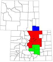
- Central ColoradoCentral ColoradoCentral Colorado is a region of the U.S. state of Colorado. Central Colorado is home to most of the population of the state and its geography is dominated by the Rocky Mountains, their foothills, Mesas, and Canyons, the rivers that run through them, and the open plains off of the foothills...
(part of Southern Rocky MountainsSouthern Rocky MountainsThe Southern Rocky Mountains are a major subregion of the Rocky Mountains of North America located in the southern portion of the U.S. state of Wyoming, the central and western portions of Colorado, the northern portion of New Mexico, and extreme eastern portions of Utah...
) - Colorado Eastern PlainsColorado Eastern PlainsThe Eastern Plains of Colorado refers to a region of the U.S. state of Colorado east of the Rocky Mountains and east of the population centers of the Front Range.-Geography:...
(part of High PlainsHigh Plains (United States)The High Plains are a subregion of the Great Plains mostly in the Western United States, but also partly in the Midwest states of Nebraska, Kansas, and South Dakota, generally encompassing the western part of the Great Plains before the region reaches the Rocky Mountains...
and Great PlainsGreat PlainsThe Great Plains are a broad expanse of flat land, much of it covered in prairie, steppe and grassland, which lies west of the Mississippi River and east of the Rocky Mountains in the United States and Canada. This area covers parts of the U.S...
) - Colorado Front RangeColorado Front RangeThe Colorado Front Range is a colloquial geographic term for the most populous region of the state of Colorado in the United States. The area is located just east of the foothills of the Front Range, aligned in a north-south configuration on the western edge of the Great Plains, where they meet the...
(part of Front Range Urban CorridorFront Range Urban CorridorThe Front Range Urban Corridor is an oblong region of urban population located along the eastern face of the Southern Rocky Mountains in the U.S. states of Colorado and Wyoming. The corridor derives its name from the Front Range, the mountain range that defines the west central boundary of the...
) - Colorado Mineral BeltColorado Mineral BeltThe Colorado Mineral Belt is an area with abundant ore deposits. The area stretches north-east from the La Plata Mountains in Southwestern Colorado to the Front Range near Boulder, Colorado...
(part of Southern Rocky MountainsSouthern Rocky MountainsThe Southern Rocky Mountains are a major subregion of the Rocky Mountains of North America located in the southern portion of the U.S. state of Wyoming, the central and western portions of Colorado, the northern portion of New Mexico, and extreme eastern portions of Utah...
) - Colorado PiedmontColorado PiedmontThe Colorado Piedmont is the geologic term for an area along the base of the foothills of the Front Range in north central Colorado in the United States...
(contains parts of the Front Range Urban CorridorFront Range Urban CorridorThe Front Range Urban Corridor is an oblong region of urban population located along the eastern face of the Southern Rocky Mountains in the U.S. states of Colorado and Wyoming. The corridor derives its name from the Front Range, the mountain range that defines the west central boundary of the...
and High PlainsHigh Plains (United States)The High Plains are a subregion of the Great Plains mostly in the Western United States, but also partly in the Midwest states of Nebraska, Kansas, and South Dakota, generally encompassing the western part of the Great Plains before the region reaches the Rocky Mountains...
) - Colorado Western SlopeColorado Western SlopeThe Western Slope of Colorado refers to a region of the U.S. state of Colorado incorporating everything in the state west of the Continental Divide. The Colorado River and its tributaries divide the region into north and south at Grand Junction, Colorado...
(part of Southern Rocky MountainsSouthern Rocky MountainsThe Southern Rocky Mountains are a major subregion of the Rocky Mountains of North America located in the southern portion of the U.S. state of Wyoming, the central and western portions of Colorado, the northern portion of New Mexico, and extreme eastern portions of Utah...
and Colorado PlateauColorado PlateauThe Colorado Plateau, also called the Colorado Plateau Province, is a physiographic region of the Intermontane Plateaus, roughly centered on the Four Corners region of the southwestern United States. The province covers an area of 337,000 km2 within western Colorado, northwestern New Mexico,...
) - Denver-Aurora Metropolitan AreaDenver-Aurora Metropolitan AreaThe Denver-Aurora-Broomfield, CO Metropolitan Statistical Area is a United States Census Bureau defined Metropolitan Statistical Area in the State of Colorado that includes the City and County of Denver and nine suburban counties. The Census Bureau estimates that the population was 2,357,404 on...
(part of Front Range Urban CorridorFront Range Urban CorridorThe Front Range Urban Corridor is an oblong region of urban population located along the eastern face of the Southern Rocky Mountains in the U.S. states of Colorado and Wyoming. The corridor derives its name from the Front Range, the mountain range that defines the west central boundary of the...
) - High RockiesHigh RockiesThe High Rockies, or high country, is a term for a region of the U.S. state of Colorado. It commonly includes Larimer County, Jackson County, Routt County, Grand County, Summit County, Eagle County, Lake County, and Pitkin County. Some notable towns there include Estes Park, Walden, Steamboat...
(part of Southern Rocky MountainsSouthern Rocky MountainsThe Southern Rocky Mountains are a major subregion of the Rocky Mountains of North America located in the southern portion of the U.S. state of Wyoming, the central and western portions of Colorado, the northern portion of New Mexico, and extreme eastern portions of Utah...
) - Northwestern ColoradoNorthwestern ColoradoNorthwestern Colorado is a region in the northwest portion of Colorado. It borders Western Colorado, Northern Colorado, the north portion of Central Colorado, Southwestern Colorado, Utah, and the northwest state of Wyoming...
(part of Southern Rocky MountainsSouthern Rocky MountainsThe Southern Rocky Mountains are a major subregion of the Rocky Mountains of North America located in the southern portion of the U.S. state of Wyoming, the central and western portions of Colorado, the northern portion of New Mexico, and extreme eastern portions of Utah...
) - San Luis ValleySan Luis ValleyThe San Luis Valley is an extensive alpine valley in the U.S. states of Colorado and New Mexico covering approximately and sitting at an average elevation of above sea level. The valley sits atop the Rio Grande Rift and is drained to the south by the Rio Grande River, which rises in the San Juan...
- South-Central ColoradoSouth-Central ColoradoSouth-Central Colorado is a region of the U.S. state of Colorado. It can be roughly defined by Chaffee County in the northwest, El Paso County in the northeast, Las Animas County in the southeast, and Conejos County in the southwest. Some notable towns there include Colorado Springs, Pueblo,...
(part of Front Range Urban CorridorFront Range Urban CorridorThe Front Range Urban Corridor is an oblong region of urban population located along the eastern face of the Southern Rocky Mountains in the U.S. states of Colorado and Wyoming. The corridor derives its name from the Front Range, the mountain range that defines the west central boundary of the...
) - Southwestern ColoradoSouthwestern ColoradoSouthwestern Colorado is a region in the southwest portion of Colorado. It is bordered by Western Colorado, Southern Colorado, the south portion of Central Colorado, Utah, and New Mexico.-Counties:*Alamosa County*Archuleta County*Conejos County*Dolores County...
(part of Southern Rocky MountainsSouthern Rocky MountainsThe Southern Rocky Mountains are a major subregion of the Rocky Mountains of North America located in the southern portion of the U.S. state of Wyoming, the central and western portions of Colorado, the northern portion of New Mexico, and extreme eastern portions of Utah...
and Colorado PlateauColorado PlateauThe Colorado Plateau, also called the Colorado Plateau Province, is a physiographic region of the Intermontane Plateaus, roughly centered on the Four Corners region of the southwestern United States. The province covers an area of 337,000 km2 within western Colorado, northwestern New Mexico,...
)
Connecticut

Connecticut
Connecticut is a state in the New England region of the northeastern United States. It is bordered by Rhode Island to the east, Massachusetts to the north, and the state of New York to the west and the south .Connecticut is named for the Connecticut River, the major U.S. river that approximately...
. There are also a fair number of unofficial regions in Connecticut with no regional government.
- Coastal ConnecticutCoastal ConnecticutCoastal Connecticut, often colloquially referred to by state residents as the Connecticut Shore or the Connecticut Shoreline, comprises all of Connecticut's southern border along Long Island Sound, from Greenwich in the west to Stonington in the east, as well as the tidal portions of the Housatonic...
- Connecticut PanhandleConnecticut PanhandleThe Connecticut Panhandle, informally known to locals as the Tail, is in southwestern Connecticut, where it abuts New York State. It is contained entirely in Fairfield County and includes all of Greenwich, Stamford, New Canaan, and Darien, as well as part of Norwalk and containing some of the most...
- New York Metropolitan AreaNew York metropolitan areaThe New York metropolitan area, also known as Greater New York, or the Tri-State area, is the region that composes of New York City and the surrounding region...
/Gold CoastGold Coast (Connecticut)The Gold Coast, also known as Southwestern Connecticut or Lower Fairfield County, is a region of the state of Connecticut, United States, that includes the entire southern portion of Fairfield County as defined by the U.S. Census Bureau, Super-Public Use Microdata Area Region 09600.This area is... - Litchfield HillsLitchfield HillsThe Litchfield Hills is a geographic region of the U.S. state of Connecticut located in the northwestern corner of the state. It is a term that is roughly coterminous with the boundaries of Litchfield County, for which it is named...
- Naugatuck River ValleyNaugatuck River ValleyThe Naugatuck River Valley refers to the watershed area of the Naugatuck River in the western part of Connecticut. The Naugatuck Valley straddles parts of Litchfield County, New Haven, and Fairfield counties. The Route 8 corridor and Waterbury Branch of the Metro-North railroad line run along the...
- Greater BridgeportGreater BridgeportGreater Bridgeport is the metropolitan area centered on the city of Bridgeport in the U.S. state of Connecticut. The area is located in Southwestern Connecticut and consists of the city of Bridgeport and five other adjacent towns – Easton, Fairfield, Monroe, Stratford, and Trumbull...
- Greater New HavenGreater New HavenGreater New Haven is the metropolitan area whose extent includes those towns in the U.S. state of Connecticut that share an economic, social, political, and historical focus on the city of New Haven...
- Greater HartfordGreater HartfordGreater Hartford is a region located in the state of Connecticut, centered on the state's capital of Hartford.Hartford's role as a focal point for the American insurance industry is known nationally. The vibrant music and arts scene defines the region's culture...
- Lower Connecticut River ValleyLower Connecticut River ValleyThe Lower Connecticut River Valley is a region of the state of Connecticut focused around the juncture where the Connecticut River meets Long Island Sound. It includes towns in southern Middlesex County and the western edge of New London County...
- Quiet CornerQuiet CornerThe Quiet Corner, also known as Northeastern Connecticut, is a region of the state of Connecticut, located in the northeastern corner of the state. It is generally associated with Windham County, but also incorporates eastern sections of Tolland County and the northern portion of New London County...
- Southeastern ConnecticutSoutheastern ConnecticutThe Southeastern Connecticut region comprises, as the name suggests, the southeastern corner of the state of Connecticut. It is sometimes referred to as Greater New London or by the tourist slogan Mystic and More....
- Southwestern Connecticut
Florida
- Big BendBig Bend (Florida)The Big Bend of Florida, U.S.A., is an informal region of the state with no official surveyed boundary. It includes part of the counties of the Florida Panhandle. Geologists prefer to characterize Florida’s Big Bend as the drowned karst section of the coast that occurs between the mouth of the...
- Central FloridaCentral FloridaCentral Florida is a regional designation for the area surrounding Orlando in east central Florida, United States. The area represents the third largest population concentration in Florida, after the South Florida and Tampa Bay regions, respectively....
- Greater Orlando
- EvergladesEvergladesThe Everglades are subtropical wetlands in the southern portion of the U.S. state of Florida, comprising the southern half of a large watershed. The system begins near Orlando with the Kissimmee River, which discharges into the vast but shallow Lake Okeechobee...
- First CoastFirst CoastThe First Coast is a region of Florida, in the United States. It extends along the Atlantic, or eastern, coast of the state, from the Georgia border, past the southern end of Anastasia Island, to Marineland....
- Florida HeartlandFlorida HeartlandThe Florida Heartland is a region of Florida located to the north and west of Lake Okeechobee, composed of six inland, non-metropolitan counties — DeSoto, Glades, Hardee, Hendry, Highlands, and Okeechobee. In 2000, The US Census Bureau recorded the population of the region at 229,509...
- Florida KeysFlorida KeysThe Florida Keys are a coral archipelago in southeast United States. They begin at the southeastern tip of the Florida peninsula, about south of Miami, and extend in a gentle arc south-southwest and then westward to Key West, the westernmost of the inhabited islands, and on to the uninhabited Dry...
- Florida PanhandleFlorida PanhandleThe Florida Panhandle, an informal, unofficial term for the northwestern part of Florida, is a strip of land roughly 200 miles long and 50 to 100 miles wide , lying between Alabama on the north and the west, Georgia also on the north, and the Gulf of Mexico to the south. Its eastern boundary is...
- Emerald CoastEmerald CoastThe Emerald Coast is an area in the US state of Florida on the coast of the Gulf of Mexico which stretches about 100 miles through four counties, Santa Rosa, Okaloosa, Walton, and Bay, from Gulf Breeze on the east side of Pensacola Bay to Panama City on the east side of the St...
- Emerald Coast
- Fun CoastFun CoastThe Fun Coast is a region of Florida, in the United States. It extends along the Atlantic, or eastern, coast of the state, from Marineland to Canaveral National Seashore, and includes all of Flagler County and Volusia County. It is bounded by the Space Coast on the south and by the First Coast on...
- Nature CoastNature CoastThe Nature Coast is a region of the U.S. state of Florida. It comprises the inside curve or Big Bend area of the western coast of the state and encompasses Citrus, Dixie, Hernando, Jefferson, Pasco, Levy, Taylor, and Wakulla counties...
- North Central FloridaNorth Central FloridaNorth Central Florida is a region of the U.S. state of Florida which comprises the north-central part of the state and encompasses the Gainesville, Florida Metropolitan Statistical Area , Bradford, Columbia, Hamilton, Lafayette, Madison, Marion, Putnam, Suwannee and Union counties...
- South Florida metropolitan areaSouth Florida metropolitan areaThe South Florida metropolitan area, also known as the Miami metropolitan area, and designated the Miami–Fort Lauderdale–Pompano Beach, FL Metropolitan Statistical Area by the U.S...
- Gold CoastGold Coast (Florida)The Gold Coast is the region of the southeastern coast of the U.S. state of Florida between Tequesta and Florida City. The region consists of the long urban cluster that runs along the eastern shores of Palm Beach, Broward, and Miami-Dade County; also called the South Florida metropolitan area...
- Gold Coast
- Southwest FloridaSouthwest FloridaSouthwest Florida is a region of Florida , United States located along its gulf coast, south of the Tampa Bay area, west of Lake Okeechobee and mostly north of the Everglades...
- Space CoastSpace CoastThe Space Coast is a region in the U.S. state of Florida around Kennedy Space Center , where NASA launched space shuttles until the last one on July 8th, 2011 at 11:29am; and Cape Canaveral Air Force Station, site of unmanned civilian and military space launches...
- SuncoastFlorida SuncoastThe Florida Suncoast is a colloquial name for the west-central and southwest peninsular Florida coastal area between Tarpon Springs to the north, and Naples to the south, and includes the Tampa Bay Area. This region is sometimes also referred to as the Sun Coast...
- Tampa Bay AreaTampa Bay AreaThe Tampa Bay Area is the region of west central Florida adjacent to Tampa Bay. Definitions of the region vary. It is often considered equivalent to the Tampa-St. Petersburg-Clearwater Metropolitan Statistical Area defined by the United States Census Bureau. The Census Bureau currently...
- Treasure CoastTreasure CoastThe Treasure Coast is a region in the U.S. state of Florida, generally considered to include Indian River, St. Lucie, and Martin counties. The area stretches from Hobe Sound in the south to north of Sebastian in the north and includes the cities of Stuart, Port St. Lucie, Fort Pierce, and Vero Beach...
Georgia
- Central Savannah River AreaCentral Savannah River AreaThe Central Savannah River Area is a 13-county region in the U.S. state of Georgia, and is also considered to include five to eight counties in South Carolina. The term was coined in 1950 by C.C. McCollum, the winner of a $250 contest held by The Augusta Chronicle to generate the best name for the...
- Colonial CoastColonial CoastSoutheastern Georgia's Lower Coastal Plain is a subregion that encompasses the lowest lying areas of the Atlantic coastal plain in the state, containing barrier islands, marshes, and swampy lowlands, as well as flat plains and low terraces. It differs from Georgia's Upper Coastal Plain in that it...
- North Georgia mountainsNorth Georgia mountainsThe Georgia Mountains Region or North Georgia mountains or Northeast Georgia is an area that starts in the northeast corner of Georgia, United States, and spreads in a westerly direction. The mountains in this region are in the Blue Ridge mountain chain that ends in Georgia...
- The Golden Isles of GeorgiaThe Golden Isles of GeorgiaThe Golden Isles of Georgia are a group of four barrier islands on the 100-mile-long coast of Georgia on the Atlantic Ocean. They include St. Simons Island, Sea Island, Jekyll Island, Little St. Simons Island, and Historic Brunswick. They are part of the Sea Islands.Since the American Civil War,...
- Historic SouthHistoric SouthHistoric South is an area in central and east-central Georgia, United States. The region carries a strong cultural and architectural heritage. It contains three chief areas: Historic Heartland, Classic South, and Magnolia Midlands.-Geography:...
- Inland Empire
- Atlanta metropolitan area
- Southern RiversSouthern RiversSouthern Rivers is an area in southwest Georgia, United States, spreading north.-Geography:The Southern Rivers Region constitutes the southwest corner of the state of Georgia and is made up of the following...
Physiographic Regions of Georgia
- Appalachian PlateauAppalachian PlateauThe Appalachian Plateau is the western part of the Appalachian mountains, stretching from New York and Alabama. The plateau is a second level United States physiographic region....
- Ridge and Valley
- Blue Ridge MountainsBlue Ridge MountainsThe Blue Ridge Mountains are a physiographic province of the larger Appalachian Mountains range. This province consists of northern and southern physiographic regions, which divide near the Roanoke River gap. The mountain range is located in the eastern United States, starting at its southern-most...
- Piedmont Plateau
- Coastal PlainCoastal plainA coastal plain is an area of flat, low-lying land adjacent to a seacoast and separated from the interior by other features. One of the world's longest coastal plains is located in eastern South America. The southwestern coastal plain of North America is notable for its species diversity...
Hawaii
- HawaiiHawaii (island)The Island of Hawaii, also called the Big Island or Hawaii Island , is a volcanic island in the North Pacific Ocean...
/ Big IslandHawaii (island)The Island of Hawaii, also called the Big Island or Hawaii Island , is a volcanic island in the North Pacific Ocean...
- Hamakua Coast
- Puna DistrictPuna, HawaiiPuna is one of the nine districts in Hawaii County, Big Island, Hawaii. The District of Puna is located on the easternmost portion of the island and shares borders to the north with the District of South Hilo and a border to the west with the District of Kaū...
- KahoolaweKahoolaweKahoolawe is the smallest of the eight main volcanic islands in the Hawaiian Islands. Kahoolawe is located about seven miles southwest of Maui and also southeast of Lanai, and it is long by wide, with a total land area of . The highest point on Kahoolawe is the crater of Lua Makika at the...
- KauaiKauaiKauai or Kauai, known as Tauai in the ancient Kaua'i dialect, is geologically the oldest of the main Hawaiian Islands. With an area of , it is the fourth largest of the main islands in the Hawaiian archipelago, and the 21st largest island in the United States. Known also as the "Garden Isle",...
- LānaiLanaiLānai or Lanai is the sixth-largest of the Hawaiian Islands. It is also known as the Pineapple Island because of its past as an island-wide pineapple plantation. The only town is Lānai City, a small settlement....
- MauiMauiThe island of Maui is the second-largest of the Hawaiian Islands at and is the 17th largest island in the United States. Maui is part of the state of Hawaii and is the largest of Maui County's four islands, bigger than Lānai, Kahoolawe, and Molokai. In 2010, Maui had a population of 144,444,...
- MolokaiMolokaiMolokai or Molokai is an island in the Hawaiian archipelago. It is 38 by 10 miles in size with a land area of , making it the fifth largest of the main Hawaiian Islands and the 27th largest island in the United States. It lies east of Oahu across the 25-mile wide Kaiwi Channel and north of...
- NiihauNiihauNiihau or Niihau is the seventh largest of the inhabited Hawaiian Islands in the U.S. state of Hawaii, having an area of . Niihau lies southwest of Kauai across the Kaulakahi Channel. Several intermittent playa lakes provide wetland habitats for the Hawaiian Coot, the Black-winged Stilt, and the...
- Northwestern Hawaiian IslandsNorthwestern Hawaiian IslandsThe Northwestern Hawaiian Islands or the Leeward Islands are the small islands and atolls in the Hawaiian island chain located northwest of the islands of Kauai and Niihau. They are administered by the U.S. state of Hawaii except Midway Atoll, which has temporary residential facilities and is...
- OahuOahuOahu or Oahu , known as "The Gathering Place", is the third largest of the Hawaiian Islands and most populous of the islands in the U.S. state of Hawaii. The state capital Honolulu is located on the southeast coast...
- Tahua
Idaho
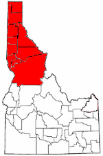
- Idaho PanhandleIdaho PanhandleThe Idaho Panhandle is the northern region of the U.S. State of Idaho that encompasses the ten northernmost counties of Benewah, Bonner, Boundary, Clearwater, Idaho, Kootenai, Latah, Lewis, Nez Perce, Shoshone. Residents of the panhandle refer to the region as North Idaho...
- Magic ValleyMagic ValleyThe Magic Valley is a region in south-central Idaho consisting of Blaine, Camas, Cassia, Gooding, Jerome, Lincoln, Minidoka and Twin Falls Counties. It is particularly associated with the agricultural region in the Snake River Plain located in the area...
- Treasure ValleyTreasure ValleyThe Treasure Valley is the area of the Western United States where the Payette, Boise, Weiser, Malheur, Owyhee, and Burnt rivers drain into the Snake River. Treasure Valley includes all the lowland areas from Vale, Oregon on the west to Boise, Idaho on the east. Formerly, the valley had been known...
- Southern IdahoSouthern IdahoSouthern Idaho is a generic geographical term roughly analogous with the areas of the U.S. state of Idaho located in the Mountain Time Zone. It particularly refers to the combined areas of the Boise metropolitan area, the Magic Valley and Eastern Idaho....
- Central IdahoCentral IdahoCentral Idaho is a geographical term located northeast of Boise and southeast of Lewiston in the U.S. state of Idaho . It is dominated by federal lands administered by the United States Forest Service and the Bureau of Land Management. Idaho's tallest mountain, Borah Peak, is located in this region...
- North IdahoIdaho PanhandleThe Idaho Panhandle is the northern region of the U.S. State of Idaho that encompasses the ten northernmost counties of Benewah, Bonner, Boundary, Clearwater, Idaho, Kootenai, Latah, Lewis, Nez Perce, Shoshone. Residents of the panhandle refer to the region as North Idaho...
- Eastern IdahoEastern IdahoEastern Idaho is a generic term used to describe areas of Idaho which lie east of the Magic Valley region. It is generally understood to include: Bannock, Bear Lake, Bingham, Bonneville, Butte, Caribou, Clark, Custer, Franklin, Fremont, Jefferson, Madison, Oneida, Power and Teton...
Illinois
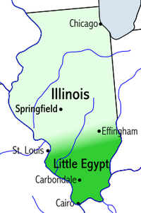
- Chicago metropolitan area
- Champaign-Urbana Metropolitan AreaChampaign-Urbana Metropolitan AreaThe Champaign-Urbana metropolitan area, also known as Champaign-Urbana, is a metropolitan area in east-central Illinois. It is the 191st largest metropolitan area in the U.S. It is composed of three counties, Champaign, Ford, and Piatt...
- Central IllinoisCentral IllinoisCentral Illinois is a region of the U.S. state of Illinois that consists of the entire central section of the state, divided in thirds from north to south. It is an area of mostly flat prairie. The western section was originally part of the Military Tract of 1812 and forms the distinctive western...
- Southern Illinois
- Shawnee HillsShawnee HillsThe Shawnee Hills is a region of Southern Illinois that rests mainly in an east-west arc roughly following the outline of the southern end of the Illinois Basin. Whereas Mississippian and Pennsylvania Age rock layers are deep beneath the surface in central Illinois, these strata pierce the surface...
- Fox ValleyFox Valley (Illinois)The Fox Valley—also commonly known as the Fox River Valley—is a rural, suburban, and exurban region within Illinois and Wisconsin along the western edges of the Chicago and Milwaukee metropolitan areas. This region centers on the Fox River of Illinois and Wisconsin...
- Metro-EastMetro-EastMetro East is a region in Illinois that comprises the eastern suburbs of St. Louis, Missouri, United States. It encompasses five Southern Illinois counties in the St. Louis Metropolitan Statistical Area. The region's most populated city is Belleville at 45,000 residents...
- American BottomAmerican BottomThe American Bottom is the flood plain of the Mississippi River in the Metro-East region of Southern Illinois, extending from Alton, Illinois, to the Kaskaskia River. It is also sometimes called "American Bottoms". The area is about , mostly protected from flooding by a levee and drainage canal...
- The TractMilitary Tract of 1812In May 1812, an act of Congress was passed which set aside bounty lands as payment to volunteer soldiers for the War against the British...
- Northwestern IllinoisNorthwestern IllinoisNorthwestern Illinois is a geographic region of the state of Illinois within the USA.Northwestern Illinois is generally considered to consist of the following area: Jo Daviess County, Carroll County, Whiteside County, Stephenson County, Winnebago County, Ogle County, and Lee County...
- River Bend (Illinois)River Bend (Illinois)The River Bend is a small region in western central Illinois and Southern Illinois that comprises parts of three counties: Madison, Calhoun, and Jersey. The name comes from a section of Mississippi River that flows roughly west to east instead of the usual north to south, causing a bend in the...
- Metro LakelandMetro LakelandMetro Lakeland is a name that was coined for an area of southern Illinois that is centered around the intersections of Interstate 57, Interstate 24, and Illinois Route 13 — a four-lane east-west highway connecting the communities of Murphysboro, Carbondale, Carterville, Herrin, Marion, and Harrisburg...
- River Region Evening Edition
Indiana
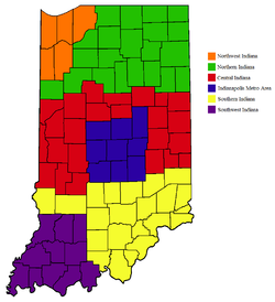
- East Central IndianaEast Central IndianaEast Central Indiana is a region in Indiana east of Indianapolis, Indiana, and borders the Ohio state line.- Counties :*Blackford*Delaware*Hancock*Henry*Jay*Madison*Randolph*Wayne- County seats :*Anderson, Indiana-Madison...
- Indianapolis metropolitan area
- MichianaMichianaMichiana is a region in northern Indiana and southwestern Michigan centered on the city of South Bend, Indiana. The Chamber of Commerce of St. Joseph County, Indiana defines Michiana as "counties that contribute at least 500 inbound commuting workers to St. Joseph County daily." Those counties...
- Northern IndianaNorthern IndianaNorthern Indiana is the region of Indiana including 26 counties bordering parts of Illinois, Michigan, and Ohio. The area is generally sub-classified into other regions. The northwest is economically and culturally intertwined with Chicago, and is considered part of the Chicago metropolitan area...
- Northwest IndianaNorthwest IndianaNorthwest Indiana, also known as the South Shore and The Calumet Region or simply The Region, comprises Lake, Porter, LaPorte, Newton and Jasper counties in Indiana. This region neighbors Lake Michigan and is part of the Chicago metropolitan area...
- Southern IndianaSouthern IndianaSouthern Indiana, in the United States, consists of the 33 counties located in the southernmost part of the state. The region's history and geography has led to a blend of Northern and Southern culture distinct from the remainder of Indiana. It is often considered to be part of the Upland South...
- Southwestern IndianaSouthwestern IndianaSouthwestern Indiana is a 11-county region of Indiana located at the southernmost and westernmost part of the state. As of the 2000 census, the region's combined population is 465,338. Evansville, Indiana's third largest city, is the primary hub for the region as well as the primary regional hub...
- Wabash ValleyWabash ValleyThe Wabash Valley is a region with parts in both Illinois and Indiana. It is named for the Wabash River and spans the middle to the middle-lower portion of the river and is centered at Terre Haute, Indiana...
Iowa
- Central Iowa
- Des Moines metropolitan areaDes Moines metropolitan areaThe Des Moines metropolitan area, officially known as the Des Moines-West Des Moines Metropolitan Statistical Area , consists of five counties in central Iowa, United States: Polk, Dallas, Warren, Madison, and Guthrie...
- Iowa Great LakesIowa Great LakesThe Iowa Great Lakes are a group of natural glacial lakes in Dickinson County in northwestern Iowa in the United States. The three principal lakes of the group are Spirit Lake, West Okoboji Lake, and East Okoboji Lake. They are the largest natural lakes in the state of Iowa. The largest, Spirit...
- Loess HillsLoess HillsThe Loess Hills are a formation of wind-deposited loess soil in the westernmost part of Iowa and Missouri along the Missouri River.-Geology:The Loess Hills are generally located between 1 and east of the Missouri River channel...
- Quad CitiesQuad CitiesThe Quad Cities is a group of five cities straddling the Mississippi River on the Iowa–Illinois boundary. These cities, Davenport and Bettendorf and Rock Island, Moline, and East Moline , are the center of the Quad Cities Metropolitan Area, which, as of 2010, had an estimated population of...
- East-Central Iowa
- Eastern Iowa
- Great River RoadGreat River RoadThe Great River Road is a collection of state, provincial, federal, and local roads which follow the course of the Mississippi River through ten states of the United States...
- Western Iowa
Kansas
- East-Central KansasEast-Central KansasEast-Central Kansas is a region of Kansas. Extending roughly from Osage County, Franklin County, and Miami County in the north to Coffey County, Anderson County and Linn County in the south. The eastern border is Missouri. The region then extends westward towards the Flint Hills to Lyon County...
- Flint HillsFlint HillsThe Flint Hills, historically known as Bluestem Pastures or Blue Stem Hills, are a band of hills in eastern Kansas stretching into north-central Oklahoma, extending from Marshall County, Kansas and Washington County, Kansas in the north to Cowley County, Kansas and Osage County, Oklahoma in the south...
- Kansas City Metropolitan AreaKansas City Metropolitan AreaThe Kansas City Metropolitan Area is a fifteen-county metropolitan area that is anchored by Kansas City, Missouri and is bisected by the border between the states of Missouri and Kansas. As of the 2010 Census, the metropolitan area has a population of 2,035,334. The metropolitan area is the...
- Red Hills
- Smoky HillsSmoky HillsThe Smoky Hills are an upland region of hills in the central Great Plains of North America. They are located in the central United States, encompassing north-central Kansas and a small portion of south-central Nebraska. The hills are a dissected plain covered by tallgrass and mixed-grass prairie...
- South Central Kansas
- Southeast KansasSoutheast KansasSoutheast Kansas is a region of the U.S. state of Kansas. It can be roughly defined by Woodson County in the northwest, Bourbon County in the northeast, Cherokee County in the southeast, and Montgomery County in the southwest. Geographically it is dominated by a broad rolling landscape located...
- Western Kansas
Kentucky
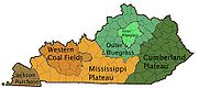
- The BluegrassBluegrass regionThe Bluegrass Region is a geographic region in the state of Kentucky, United States. It occupies the northern part of the state and since European settlement has contained a majority of the state's population and its largest cities....
- Central KentuckyCentral KentuckyCentral Kentucky is sometimes considered the Central and Southern part of the Bluegrass region, the Far Upper Western Eastern Mountain Coal Fields, and the Far Upper Eastern Pennyroyal regions. Its major cities include Lexington and Frankfort. Lexington citizens, especially radio and TV stations...
- Cumberland PlateauCumberland PlateauThe Cumberland Plateau is the southern part of the Appalachian Plateau. It includes much of eastern Kentucky and western West Virginia, part of Tennessee, and a small portion of northern Alabama and northwest Georgia . The terms "Allegheny Plateau" and the "Cumberland Plateau" both refer to the...
- Eastern Mountain Coal FieldsEastern Mountain Coal FieldsThe Eastern Mountain Coal Fields is part of the Central Appalachian bituminous coal field, covering all or parts of 30 Kentucky counties and adjoining areas in Ohio, West Virginia, Virginia and Tennessee. It covers an area from the Allegheny Mountains in the east across the Cumberland Plateau and...
- Kentucky BendKentucky BendThe Kentucky Bend, variously called the New Madrid Bend, Madrid Bend, Bessie Bend, or Bubbleland, is an exclave of Fulton County, Kentucky, in the United States....
- The KnobsKnobs regionThe Knobs Region is located in the US state of Kentucky. It is a narrow, horseshoe shaped region consisting of hundreds of isolated hills. The region wraps around the bluegrass region in the center of the state...
- Northern KentuckyNorthern KentuckyNorthern Kentucky is the name often given to the northernmost counties in Kentucky...
- Pennyroyal PlateauPennyroyal PlateauThe Pennyroyal Plateau, or, as it is more commonly called in Kentucky, the Pennyrile, is a large area of the state that features rolling hills, caves, and karst topography in general. It is also called the "Mississippi Plateau"....
- The PurchaseJackson PurchaseThe Jackson Purchase is a region in the state of Kentucky bounded by the Mississippi River to the west, the Ohio River to the north, and Tennessee River to the east. Although technically part of Kentucky at its statehood in 1792, the land did not come under definitive U.S. control until 1818, when...
- Western Coal FieldsWestern Coal Fieldsthumb|right|Regions of Kentucky, with the Western Coal Fields shown in brownThe Western Coal Fields of Kentucky compose an area in the west-central part of the state, bounded by the Dripping Springs Escarpment. This area is bordered on three sides by the Pennyroyal Plateau and to the north by the...
Louisiana
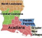
- AcadianaAcadianaAcadiana, or The Heart of Acadiana, is the official name given to the French Louisiana region that is home to a large Francophone population. Of the 64 parishes that make up Louisiana, 22 named parishes and other parishes of similar cultural environment, make up the intrastate...
- Cajun Heartland
- River ParishesRiver ParishesThe River Parishes are those parishes in Louisiana between New Orleans and Baton Rouge that span both banks of the Mississippi River, and are officially part of the Acadiana region. Traditionally they are considered to be St. Charles Parish, St. James Parish and St. John the Baptist Parish. St....
- Central LouisianaCentral LouisianaCentral Louisiana , also known as the Crossroads region, is the part of Louisiana that includes the following parishes: Allen Parish, Beauregard Parish, Catahoula Parish, Concordia Parish, Grant Parish, La Salle Parish, Natchitoches Parish, Rapides Parish, Sabine Parish and Vernon Parish.The five...
(Cen-La) - Florida ParishesFlorida ParishesThe Florida Parishes , also known as the North Shore region, are eight parishes in the southeastern part of the U.S. state of Louisiana, which were part of West Florida in the 18th and early 19th centuries. Unlike much of Louisiana, this region was not part of the Louisiana Purchase, as it had been...
- French LouisianaLouisiana (New France)Louisiana or French Louisiana was an administrative district of New France. Under French control from 1682–1763 and 1800–03, the area was named in honor of Louis XIV, by French explorer René-Robert Cavelier, Sieur de la Salle...
(Acadiana + Greater New Orleans) - Greater New Orleans
- North LouisianaNorth LouisianaNorth Louisiana is a region in the U.S. state of Louisiana. The region has two metropolitan areas: Shreveport-Bossier City and Monroe-West Monroe....
Maine
- Down EastDown EastIn New England, the term Down East is applied in several different ways. In the narrowest sense, Down East refers to the coast of the U.S. state of Maine from Penobscot Bay to the Canadian border....
- High PeaksHigh Peaks (Maine)The High Peaks is a region of the US state of Maine, lying entirely within Franklin County. It is roughly bounded by State Route 4 to the southwest, State Route 16 to the northwest, State Route 16/27 to the northeast and State Route 142 to the southeast. The region contains eight of the 14 Maine...
/ Maine HighlandsMaine HighlandsThe Maine Highlands is now a term used in the Maine tourism industry for a centrally located region that constitutes a large portion of the state of Maine. The Highlands are made up of Piscataquis and Penobscot counties... - Kennebec ValleyKennebec ValleyThe Kennebec Valley is a region of the U.S. state of Maine, consisting of the Kennebec and Androscoggin Counties. The area formed as a result of the Wisconsin Glaciation....
- Maine HighlandsMaine HighlandsThe Maine Highlands is now a term used in the Maine tourism industry for a centrally located region that constitutes a large portion of the state of Maine. The Highlands are made up of Piscataquis and Penobscot counties...
- Maine Lake CountryMaine Lake CountryThe Maine Lake Country is a region of the U.S. state of Maine commonly including Oxford, Franklin, Somerset, Piscataquis, Penobscot, and Aroostook. Some notable towns are Norway, Farmington, Madison, Dover-Foxcroft, Bangor, and Houlton...
- Maine North WoodsMaine North WoodsThe Maine North Woods is the northern geographic area of the state of Maine in the United States.It covers more than 3.5 million acres of top forest land in north-western Maine. It includes western Aroostook and northern Somerset, Penobscot, and Piscataquis counties...
- Mid CoastMid CoastThe Mid Coast is a region of Maine that includes the many small coastal towns of Lincoln, Knox, Waldo, Sagadahoc, and the northern coastal portion of Cumberland counties...
- Penobscot BayPenobscot BayPenobscot Bay originates from the mouth of Maine's Penobscot River. There are many islands in this bay, and on them, some of the country's most well-known summer colonies. The bay served as portal for the one time "lumber capital of the world," namely; the city of Bangor...
- Southern Maine CoastSouthern Maine CoastThe Southern Maine Coast is a region of the U.S. state of Maine. It commonly includes York County, Cumberland County. Some notable towns are Kittery, York, Wells, Ogunquit, Kennebunkport, Saco, and Scarborough...
- Western Maine MountainsWestern Maine MountainsThe Western Maine Mountains region spans most of Maine's western border with New Hampshire. A small part of the scenic White Mountain National Forest is located in this area. This is essentially all of Oxford County and northern York County and Cumberland Counties. Notable towns include Bethel,...
Maryland
- Baltimore-Washington Metropolitan AreaBaltimore-Washington Metropolitan AreaThe Baltimore-Washington Metropolitan Area is a combined statistical area consisting of the overlapping labor market region of the cities of Baltimore, Maryland and Washington, D.C.. The region includes Central Maryland, Northern Virginia, and Jefferson County in the Eastern Panhandle of West...
- Chesapeake BayChesapeake BayThe Chesapeake Bay is the largest estuary in the United States. It lies off the Atlantic Ocean, surrounded by Maryland and Virginia. The Chesapeake Bay's drainage basin covers in the District of Columbia and parts of six states: New York, Pennsylvania, Delaware, Maryland, Virginia, and West...
- Eastern Shore of MarylandEastern Shore of MarylandThe Eastern Shore of Maryland is a territorial part of the U.S. state of Maryland that lies predominately on the east side of the Chesapeake Bay and consists of nine counties. The origin of term Eastern Shore was derived to distinguish a territorial part of the State of Maryland from the Western...
- Southern MarylandSouthern MarylandSouthern Maryland in popular usage is composed of the state's southernmost counties on the "Western Shore" of the Chesapeake Bay. This region includes all of Calvert, Charles and St. Mary's counties and sometimes the southern portions of Anne Arundel and Prince George's counties.- History...
- Western MarylandWestern MarylandWestern Maryland is the portion of the U.S. state of Maryland that consists of Frederick, Washington, Allegany, and Garrett counties. The region is bounded by the Mason-Dixon line to the north, Preston County, West Virginia to the west, and the Potomac River to the south. There is dispute over the...
- Capital regionCapital regionA capital region, also called a national capital region, capital district or capital territory is a common term for the region or district surrounding the capital city of a country or any other administrative division...
Massachusetts
- The BerkshiresThe BerkshiresThe Berkshires , is a highland geologic region located in the western parts of Massachusetts and Connecticut.Also referred to as the Berkshire Hills, Berkshire Mountains, and Berkshire Plateau, the region enjoys a vibrant tourism industry based on music, arts, and recreation.-Definition:The term...
(map shown, right) - Cape AnnCape AnnCape Ann is a rocky cape in northeastern Massachusetts on the Atlantic Ocean. The cape is located approximately 30 miles northeast of Boston and forms the northern edge of Massachusetts Bay. Cape Ann includes the city of Gloucester, and the towns of Essex, Manchester-by-the-Sea, and...
- Cape CodCape CodCape Cod, often referred to locally as simply the Cape, is a cape in the easternmost portion of the state of Massachusetts, in the Northeastern United States...
- Central MassachusettsCentral MassachusettsCentral Massachusetts is the geographically central region of Massachusetts. Though definitions vary, most include all of Worcester County and the northwest corner of Middlesex County. Worcester, the largest city in the area and the seat of Worcester County, is often considered the cultural capital...
- Greater BostonGreater BostonGreater Boston is the area of the Commonwealth of Massachusetts surrounding the city of Boston. Due to ambiguity in usage, the size of the area referred to can be anywhere between that of the metropolitan statistical area of Boston and that of the city's combined statistical area which includes...
- List of islands of Massachusetts (includes Martha's VineyardMartha's VineyardMartha's Vineyard is an island located south of Cape Cod in Massachusetts, known for being an affluent summer colony....
and NantucketNantucket, MassachusettsNantucket is an island south of Cape Cod, Massachusetts, in the United States. Together with the small islands of Tuckernuck and Muskeget, it constitutes the town of Nantucket, Massachusetts, and the coterminous Nantucket County, which are consolidated. Part of the town is designated the Nantucket...
) - Merrimack ValleyMerrimack ValleyThe Merrimack Valley is a bi-state region along the Merrimack River in the states of New Hampshire and Massachusetts, United States. The Merrimack is one of the larger waterways in the New England region and has helped define the livelihood and culture of those living along it since native...
- MetroWestMetroWestMetroWest is a cluster of cities and towns lying west of Boston and east of Worcester, in the US state of Massachusetts. The name was coined in the 1980s by a local newspaper....
- North ShoreNorth Shore (Massachusetts)The North Shore is a region in the U.S. state of Massachusetts, loosely defined as the coastal area between Boston and New Hampshire. The region is made up both of a rocky coastline, dotted with marshes and wetlands, as well as several beaches and natural harbors. The North Shore is an important...
- Pioneer ValleyPioneer ValleyThe Pioneer Valley is the colloquial name for the U.S. Commonwealth of Massachusetts's portion of the Connecticut River Valley. The Pioneer Valley consists of three counties in Massachusetts which collectively feature much of New England's most fertile farmland...
- South CoastSouth Coast (Massachusetts)The South Coast of Massachusetts is the region of southeastern Massachusetts consisting of southern Bristol and Plymouth counties bordering Buzzards Bay, and includes the cities of Fall River, New Bedford, the southeastern tip of East Taunton and nearby towns...
- South Shore
- Western MassachusettsWestern MassachusettsWestern Massachusetts is a loosely defined geographical region of the U.S. state of Massachusetts which contains the Berkshires, the Pioneer Valley, and some or all of the Swift River Valley. The region is always considered to include Berkshire, Franklin, Hampshire, and Hampden counties, and the...
- Southeastern MassachusettsSoutheastern MassachusettsSoutheastern Massachusetts is a term that refers to those portions of Massachusetts which are, by their proximity, economically and culturally linked to Providence, Rhode Island as well as Boston.-Definition:...
Michigan
- Lower PeninsulaLower Peninsula of MichiganThe Lower Peninsula of Michigan is the southern of the two major landmasses of the U.S. state of Michigan. It is surrounded by water on all sides except its southern border, which it shares with Ohio and Indiana. Geographically, the Lower Peninsula has a recognizable shape that many people...
- Northern MichiganNorthern MichiganNorthern Michigan, also known as Northern Lower Michigan , is a region of the U.S. state of Michigan...
- Mid-Michigan
- Central MichiganCentral MichiganCentral Michigan, often called Mid Michigan, is a region in the Lower Peninsula of the U.S. state of Michigan. Southern Michigan can be considered as a subregion of Central Michigan. As its name implies, it is the central area of the Lower Peninsula. Lower Michigan is said to resemble a mitten, and...
- Flint/Tri-CitiesFlint/Tri-CitiesThe Flint/Tri-Cities Region or Saginaw Valley is a region in the Lower Peninsula of the U.S. state of Michigan. The region is composed of the area surrounding Flint, Michigan, the Tri Cities, the Saginaw Bay and Saginaw River . Flint's population is 102,434; it is the seventh largest city in Michigan...
- The ThumbThe ThumbThe Thumb is a region and a peninsula of Michigan, so named because the Lower Peninsula is shaped like a mitten; thus the Thumb is the area that looks like the thumb of the mitten. The Thumb is generally considered to be in the Mid-Michigan area of the state, located east of Flint/Tri-Cities...
- Southern MichiganSouthern MichiganSouthern Michigan is a loosely defined geographic area of the Lower Peninsula of the U.S. state of Michigan. Southern Michigan may be referred to as a sub-region or component area to the larger geographic regions of Central Michigan, West Michigan, and Southeast Michigan.Southern Michigan is a...
- Central Michigan
- West Michigan
- Southern MichiganSouthern MichiganSouthern Michigan is a loosely defined geographic area of the Lower Peninsula of the U.S. state of Michigan. Southern Michigan may be referred to as a sub-region or component area to the larger geographic regions of Central Michigan, West Michigan, and Southeast Michigan.Southern Michigan is a...
- MichianaMichianaMichiana is a region in northern Indiana and southwestern Michigan centered on the city of South Bend, Indiana. The Chamber of Commerce of St. Joseph County, Indiana defines Michiana as "counties that contribute at least 500 inbound commuting workers to St. Joseph County daily." Those counties...
- Southern Michigan
- Southeast MichiganSoutheast MichiganSoutheast Michigan, also called Southeastern Michigan, is a region in the Lower Peninsula of the U.S. state of Michigan that is home to a majority of the state's businesses and industries as well as slightly over half of the state's population, most of whom are concentrated in Metro...
- Metro DetroitMetro DetroitThe Detroit metropolitan area, often referred to as Metro Detroit, is the metropolitan area located in Southeast Michigan centered on the city of Detroit which shares an international border with Windsor, Ontario. The Detroit metropolitan area is the second largest U.S. metropolitan area...
- Metro Detroit
- Northern Michigan
- Upper PeninsulaUpper Peninsula of MichiganThe Upper Peninsula of Michigan is the northern of the two major land masses that make up the U.S. state of Michigan. It is commonly referred to as the Upper Peninsula, the U.P., or Upper Michigan. It is also known as the land "above the Bridge" linking the two peninsulas. The peninsula is bounded...
- Copper CountryCopper CountryThe Copper Country is an area in the Upper Peninsula of Michigan in the United States, including all of Keweenaw County, Michigan and most of Houghton, Baraga and Ontonagon counties. The area is so named as copper mining was prevalent there from 1845 until the late 1960s, with one mine ...
- Keweenaw PeninsulaKeweenaw PeninsulaThe Keweenaw Peninsula is the northern-most part of Michigan's Upper Peninsula. It projects into Lake Superior and was the site of the first copper boom in the United States. As of the 2000 census, its population was roughly 43,200...
- Copper Country
Minnesota
- Arrowhead RegionArrowhead RegionThe Arrowhead Region is located in the northeastern part of the U.S. state of Minnesota, so called because of its pointed shape. The predominantly rural region encompasses of land area and comprises Carlton, Cook, Lake and St. Louis Counties. Its population at the 2000 census was 248,425 residents...
- Boundary WatersBoundary WatersThe Boundary Waters — also called the Quetico-Superior country — is a region of wilderness straddling the Canada–United States border between Ontario and Minnesota, in the region just west of Lake Superior. This region is part of the Superior National Forest in northeastern Minnesota, and in Canada...
- Buffalo RidgeBuffalo RidgeBuffalo Ridge is a large expanse of rolling hills in the southeastern part of the larger Coteau des Prairies. It stands 1,995 feet above sea level. The Buffalo Ridge is sixty miles long and runs through Lincoln County, Pipestone County, Murray County, and Nobles County in the southwest...
- Central MinnesotaCentral MinnesotaCentral Minnesota is the name of the region consisting of the central portion of the state of Minnesota. Although no specific boundaries of the region exist, most definitions of what makes up the region would generally consist of the vast swath of land north of Interstate 94, east of U.S. Highway...
- Coulee Region
- Iron RangeIron RangeThe Iron Range is a region that makes up the northeastern section of Minnesota in the United States. "The Range", as it is known by locals, is a region with multiple distinct bands of iron ore...
- Minnesota River ValleyMinnesota RiverThe Minnesota River is a tributary of the Mississippi River, approximately 332 miles long, in the U.S. state of Minnesota. It drains a watershed of nearly , in Minnesota and about in South Dakota and Iowa....
- North ShoreNorth Shore (Lake Superior)The North Shore of Lake Superior runs from Duluth, Minnesota, United States, at the southwestern end of the lake, to Thunder Bay and Nipigon, Ontario, Canada, in the north to Sault Ste. Marie, Ontario, in the east...
- Northwest AngleNorthwest AngleThe Northwest Angle, known simply as the Angle by locals, and coextensive with Angle Township, is a part of northern Lake of the Woods County, Minnesota, and is the only place in the United States outside Alaska that is north of the 49th parallel...
- Pipestone RegionPipestone RegionThe Pipestone Region is an area in southwestern Minnesota. The area was named for its supply of pipestone a type of limestone which local Indians carved into pipes. The area is also noted for quartzite quarries. The area is one of several distinct regions of Minnesota.The Dakota were early...
- Red River ValleyRed River ValleyThe Red River Valley is a region in central North America that is drained by the Red River of the North. It is significant in the geography of North Dakota, Minnesota, and Manitoba for its relatively fertile lands and the population centers of Fargo, Moorhead, Grand Forks, and Winnipeg...
- Southeast MinnesotaSoutheast MinnesotaSoutheast Minnesota is the corner of Minnesota south of the Twin Cities metropolitan area extending east, and part of the multi-state area known as the Driftless Area. Rochester is the largest city in the area; other major cities include Winona, Owatonna, Faribault, Northfield, Austin, and Red...
- Twin Cities Metro
Mississippi
- Golden TriangleGolden Triangle (Mississippi)The Golden Triangle is a region of the U.S. state of Mississippi.The "triangle" is formed by the cities of Columbus, Starkville, and West Point...
- Mississippi PlainMississippi Alluvial PlainThe Mississippi River Alluvial Plain is an alluvial plain created by the Mississippi River on which lies parts of seven states, from southern Louisiana to southern Illinois....
- Mississippi DeltaMississippi DeltaThe Mississippi Delta is the distinctive northwest section of the U.S. state of Mississippi that lies between the Mississippi and Yazoo Rivers. The region has been called "The Most Southern Place on Earth" because of its unique racial, cultural, and economic history...
- Mississippi Gulf CoastMississippi Gulf CoastThe Mississippi Gulf Coast refers to the three Mississippi counties which lie on the Gulf of Mexico: Hancock, Harrison and Jackson counties.The region was severely damaged by Hurricane Camille in 1969 and again by Hurricane Katrina in 2005....
- Natchez DistrictNatchez DistrictThe Natchez District was one of two areas, the other being the Tombigbee District, that were the first to be colonized by British subjects from the Thirteen Colonies and elsewhere in what was West Florida and would later become the Mississippi Territory. The district was recognized to be the area...
- Pine BeltPine Belt (Mississippi)The Pine Belt, also known as the "Piney Woods", is a region in Southeast Mississippi. The region gets its name from the longleaf pine trees that are abundant in the region.- Geography :The Longleaf Pine belt covers 36 counties in Mississippi...
- Tennessee ValleyTennessee ValleyThe Tennessee Valley is the drainage basin of the Tennessee River and is largely within the U.S. state of Tennessee. It stretches from southwest Kentucky to northwest Georgia and from northeast Mississippi to the mountains of Virginia and North Carolina...
Missouri
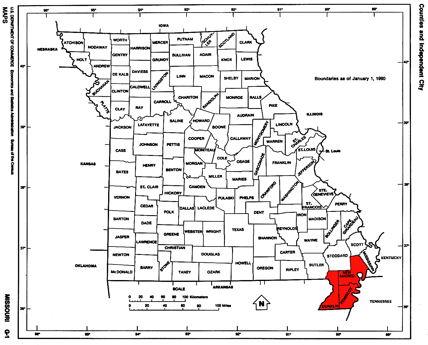
- Lead BeltLead BeltThe Southeast Missouri Lead District, commonly called the Lead Belt, is a lead mining district in the southeastern part of Missouri. Counties in the Lead Belt include Saint Francois; Crawford; Dent; Iron; Madison: Reynolds; and Washington...
- Little DixieLittle Dixie (Missouri)Little Dixie is a 13- to 17-county region of Missouri found along the Missouri River, settled primarily by migrants from the hemp and tobacco districts of Kentucky, Virginia, and Tennessee. Today, the region identifies with the Midwest, but because of Southerners settling there first, the...
- BootheelBootheelThe Missouri Bootheel is the southeasternmost part of the state of Missouri, extending south of 36°30’ north latitude, so called because its shape in relation to the rest of the state resembles the heel of a boot. Strictly speaking, it is composed of the counties of Dunklin, New Madrid, and Pemiscot...
- Natchez TraceNatchez TraceThe Natchez Trace, also known as the "Old Natchez Trace", is a historical path that extends roughly from Natchez, Mississippi to Nashville, Tennessee, linking the Cumberland, Tennessee and Mississippi rivers...
- Dissected Till PlainsDissected Till PlainsThe Dissected Till Plains are physiographic sections of the Central Lowlands province, which in turn is part of the Interior Plains physiographic division of the United States, located in southern and western Iowa, northeastern Kansas, the southwestern corner of Minnesota, northern Missouri,...
- The OzarksThe OzarksThe Ozarks are a physiographic and geologic highland region of the central United States. It covers much of the southern half of Missouri and an extensive portion of northwestern and north central Arkansas...
Montana
- Bighorn Country
- Eastern MontanaEastern MontanaEastern Montana is a loosely-defined region of Montana. Some definitions are more or less inclusive than others, ranging from the most inclusive, which would include the entire part of the state east of the eastern front of the Rocky Mountains...
- The FlatheadThe FlatheadThe Flathead, sometimes called Northwestern Montana, is a region of the U.S. state of Montana. It includes Flathead County, and part of Lake County. Notable towns include Bigfork, Kalispell, Polson, and Whitefish. The geography of the Flathead roughly corresponds to the valley where Flathead Lake...
- Glacier National Park
- South Central Montana
- Southwestern Montana
- Western MontanaWestern MontanaWestern Montana is the western region of the state of Montana, United States. Although there is no firm definition, Western Montana is roughly considered by some the western third of the state.-Geography, Biomes and Climate:...
- Glacier Country
Nebraska
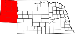
- Nebraska PanhandleNebraska PanhandleThe Nebraska Panhandle is an area in the west of the state of Nebraska. A panhandle is an area extending from the rest of a political unit; the Nebraska panhandle is two-thirds as broad as the rest of the state. It is approximately 100 miles east to west and 125 miles north to south...
- Northwest Nebraska
- Pine RidgePine Ridge (region)The Pine Ridge is an escarpment between the Niobrara River and the White River in far northwestern Nebraska...
- Rainwater BasinRainwater BasinThe Rainwater Basin is a 4,200 mi.2 region of shallow lakes, marshes and other wetlands located south of the Platte River in south-central Nebraska. In the spring and fall months, millions of migratory birds pass through the region to feed and rest...
- Sand HillsSand Hills (Nebraska)The Sand Hills, often written Sandhills, is a region of mixed-grass prairie on grass-stabilized sand dunes in north-central Nebraska, covering just over one quarter of the state...
- Southeast Nebraska
- Wildcat HillsWildcat HillsThe Wildcat Hills are an escarpment between the North Platte River and Pumpkin Creek in the western Nebraska Panhandle. Located in Banner, Morrill, and Scotts Bluff counties, the high tableland between the streams has been eroded by wind and water into a region of forested buttes, ridges and...
Nevada
- Black Rock DesertBlack Rock DesertThe Black Rock Desert is an arid region in the northern Nevada section of the Great Basin with a lakebed that is a dry remnant of Pleistocene Lake Lahontan...
- Lake TahoeLake TahoeLake Tahoe is a large freshwater lake in the Sierra Nevada of the United States. At a surface elevation of , it is located along the border between California and Nevada, west of Carson City. Lake Tahoe is the largest alpine lake in North America. Its depth is , making it the USA's second-deepest...
- Las Vegas ValleyLas Vegas metropolitan areaThe Las Vegas Valley is the heart of the Las Vegas-Paradise, NV MSA also known as the Las Vegas–Paradise–Henderson MSA which includes all of Clark County, Nevada, and is a metropolitan area in the southern part of the U.S. state of Nevada. The Valley is defined by the Las Vegas Valley landform, a ...
- Mojave DesertMojave DesertThe Mojave Desert occupies a significant portion of southeastern California and smaller parts of central California, southern Nevada, southwestern Utah and northwestern Arizona, in the United States...
- Pahranagat ValleyPahranagat ValleyThe Pahranagat Valley is a Tonopah Basin landform in Lincoln County, Nevada.The more fertile part of Pahranagat Valley is a narrow ribbon of green like an oasis in the vast Nevada desert...
- Sierra Nevada
New Hampshire
- Connecticut River Valley
- Dartmouth-Lake Sunapee RegionDartmouth-Lake Sunapee RegionThe Dartmouth-Lake Sunapee area of the U.S. state of New Hampshire, ranges from Bradford northwest along Interstate 89 to New Hampshire's border with Vermont at the city of Lebanon....
(overlaps with Connecticut River Valley) - Great North Woods RegionGreat North Woods Region (New Hampshire)The Great North Woods Region is located at the northern tip of New Hampshire, U.S.A., north of the White Mountains Region. The Great North Woods is a tourism region of New Hampshire and is located in Coos County...
- Lakes RegionLakes Region (New Hampshire)The Lakes Region of New Hampshire is the mid-state region surrounding Lake Winnipesaukee, Winnisquam Lake, Squam Lake, and Newfound Lake.The area is a popular tourist destination in the summer time, with the activity peaking during the annual Motorcycle Week and races at Loudon's New Hampshire...
- Merrimack Valley
- Golden TriangleGolden Triangle (New Hampshire)The Golden Triangle of New Hampshire is a heavily populated region between the cities of Manchester to the north, Nashua to the south, and Salem to the southeast.The region contains a substantial concentration of urban areas, suburban areas, and industry...
- Golden Triangle
- Monadnock RegionMonadnock RegionThe Monadnock Region is a tourism region in southwestern New Hampshire. It is named after Mount Monadnock, the major geographic landmark in the region. The Monadnock Region is composed of all of Cheshire County and western Hillsborough County. The largest city in the region is Keene...
(overlaps with Connecticut River Valley) - Seacoast RegionSeacoast Region (New Hampshire)The Seacoast Region is the southeast area of the U.S. state of New Hampshire. The region stretches 18 miles along the Atlantic Ocean from New Hampshire's border with Salisbury, Massachusetts to the Piscataqua River and New Hampshire's border with Kittery, Maine. The shoreline is generally very...
- White MountainsWhite Mountains (New Hampshire)The White Mountains are a mountain range covering about a quarter of the state of New Hampshire and a small portion of western Maine in the United States. Part of the Appalachian Mountains, they are considered the most rugged mountains in New England...
New Jersey
- North JerseyNorth JerseyNorth Jersey is a colloquial term, with no precise consensus definition, for the northern portion of the U.S. state of New Jersey. A straightforward, noncolloquial term for the region is northern New Jersey.- Two-portion approaches :...
- SkylandsSkylands RegionThe Skylands Region is a marketing area of the State of New Jersey located in the Northern and Central part of the state. It is one of six tourism regions established by the New Jersey State Department of Tourism, the others being the Gateway Region, Greater Atlantic City Region, the Southern...
- Amwell ValleyAmwell ValleyThe Amwell Valley is a small valley in Hunterdon County, New Jersey, between the Hunterdon Plateau and the Sourlands. It comprises Stockton, parts of Delaware Township, West Amwell, East Amwell, Flemington and Raritan Township. The region borders the Delaware River to the west and the South...
- Black Dirt RegionBlack Dirt RegionThe Black Dirt Region is located in southern Orange County, New York, USA and northern Sussex County, New Jersey. It is mostly located in the western section of the Town of Warwick, centered around the hamlet of Pine Island...
(shared with New York) - Great ValleyGreat Appalachian ValleyThe Great Valley, also called the Great Appalachian Valley or Great Valley Region, is one of the major landform features of eastern North America. It is a gigantic trough — a chain of valley lowlands — and the central feature of the Appalachian Mountain system...
- Sussex County Snow BeltSussex County Snow BeltThe Sussex County Snow Belt is a microclimate snowbelt region in Sussex County, New Jersey in northwest New Jersey. The belt is part of New Jersey's Northern Climate Zone, which receives about forty to fifty inches of snow per year...
- Sussex County Snow Belt
- Hunterdon PlateauHunterdon PlateauHunterdon Plateau is a plateau in western Hunterdon County, New Jersey. It borders the higher Musconetcong Mountain to the northwest, the Delaware River to the west, Amwell Valley to the south and the lower lying areas of the Newark Basin to the east. The plateau's edge follows a line from Raven...
- Ridge-and-Valley AppalachiansRidge-and-valley AppalachiansThe Ridge-and-Valley Appalachians, also called the Ridge and Valley Province or the Valley and Ridge Appalachians, are a physiographic province of the larger Appalachian division and are also a belt within the Appalachian Mountains extending from southeastern New York through northwestern New...
- Highlands
- Somerset HillsSomerset HillsThe Somerset Hills is a region in the northern portion of Somerset County, New Jersey, United States, almost entirely north of Interstate 78. It comprises Bernards Township , Bernardsville, Bedminster Township, Far Hills, and Peapack-Gladstone...
- The SourlandsThe SourlandsThe Sourlands is a region in the U.S. state of New Jersey that includes portions of Hunterdon County, Mercer County and Somerset County. It is centered around Sourland Mountain and comprises parts of Lambertville, East Amwell, West Amwell, Hillsborough, Hopewell Boro, Hopewell Township, Montgomery...
- Amwell Valley
- GatewayGateway RegionThe Gateway Region is located in the northeastern part of State of New Jersey in the United States of America. The area encompasses Bergen, Essex, Hudson, Passaic, Union and Middlesex counties...
- Chemical CoastChemical CoastThe Chemical Coast is the section of Union and Middlesex counties in New Jersey. It is located along the shores of the Arthur Kill, a heavily used waterway of the Port of New York and New Jersey, across from Staten Island, New York.-History:...
/Soundshore - Gold Coast
- North HudsonNorth Hudson, New JerseyNorth Hudson is the collective name of the municipalities of Weehawken , Union City , West New York , Guttenberg and North Bergen in Hudson County, New Jersey...
- North Hudson
- MeadowlandsNew Jersey MeadowlandsNew Jersey Meadowlands, also known as the Hackensack Meadowlands after the primary river flowing through it, is a general name for the large ecosystem of wetlands in northeast New Jersey in the United States. The Meadowlands are known for being the site of large landfills and decades of...
- Pascack ValleyPascack ValleyThe Pascack Valley is the name for a region of New Jersey, United States, contained within Bergen County. It is named for the Pascack Brook, which defines the valley...
- Raritan BayshoreRaritan BayshoreThe Raritan Bayshore region of New Jersey is the area around Raritan Bay from The Amboys to Sandy Hook, mostly in Monmouth County, including the towns from Keyport, New Jersey, "Pearl of the Bayshore", to Highlands, New Jersey. At Keansburg is a traditional amusement park while at Sandy Hook are...
- West HudsonWest Hudson, New JerseyWest Hudson is the collective name of the municipalities of Kearny , Harrison , and East Newark located west of the Hackensack River and east of the Passaic River in Hudson County in northeastern New Jersey. The Passaic River separates it from Newark and Belleville, and the Hackensack River...
- Chemical Coast
- Skylands
- South JerseySouth JerseySouth Jersey comprises the southern portions of the U.S. state of New Jersey between the lower Delaware River and the Atlantic Ocean. The designation is a colloquial one, reflecting not only geographical but perceived cultural differences from the northern part of the state, with no official...
- Shore RegionShore RegionThe Shore Region of the state of New Jersey encompasses Monmouth and Ocean Counties, and is often called the Jersey Shore. It is one of six such officially recognized tourism regions, the others being the Greater Atlantic City Region, the Southern Shore Region, the Delaware River Region, the...
- Northern Headlands
- Irish RivieraSpring Lake, New JerseySpring Lake is a borough in Monmouth County, New Jersey, United States. As of the 2010 United States Census, the borough population was 2,993....
- Irish Riviera
- Pine BarrensPine Barrens (New Jersey)The Pine Barrens, also known as the Pinelands, is a heavily forested area of coastal plain stretching across southern New Jersey. The name "pine barrens" refers to the area's sandy, acidic, nutrient-poor soil, to which the crops originally imported by European settlers didn't take well...
- BayshoreRaritan BayshoreThe Raritan Bayshore region of New Jersey is the area around Raritan Bay from The Amboys to Sandy Hook, mostly in Monmouth County, including the towns from Keyport, New Jersey, "Pearl of the Bayshore", to Highlands, New Jersey. At Keansburg is a traditional amusement park while at Sandy Hook are...
- Northern Headlands
- Delaware ValleyDelaware ValleyThe Delaware Valley is a term used to refer to the valley where the Delaware River flows, along with the surrounding communities. This includes the metropolitan area centered on the city of Philadelphia. Such educational institutions as Delaware Valley Regional High School in Alexandria Township...
- Pine BarrensPine Barrens (New Jersey)The Pine Barrens, also known as the Pinelands, is a heavily forested area of coastal plain stretching across southern New Jersey. The name "pine barrens" refers to the area's sandy, acidic, nutrient-poor soil, to which the crops originally imported by European settlers didn't take well...
- The SourlandsThe SourlandsThe Sourlands is a region in the U.S. state of New Jersey that includes portions of Hunterdon County, Mercer County and Somerset County. It is centered around Sourland Mountain and comprises parts of Lambertville, East Amwell, West Amwell, Hillsborough, Hopewell Boro, Hopewell Township, Montgomery...
- Pine Barrens
- Southern ShoreSouthern Shore RegionThe Southern Shore Region is located in the southeastern part of State of New Jersey in the United States of America. It is one of six tourism regions established by the New Jersey State Department of Tourism, the others being the Gateway Region, Greater Atlantic City, the Delaware River Region,...
- Cape MayCape MayCape May is a peninsula and island ; the southern tip of the island is the southernmost point of the state of New Jersey, United States. It runs southwards from the New Jersey mainland, separating Delaware Bay from the Atlantic Ocean...
- The GladesThe Glades (New Jersey)The Glades is a name for in southern New Jersey along the Delaware Bay. The formal name of this preserve is The Glades Wildlife Refuge and is publicly accessible at several points...
- Tri Cities (Bridgeton, Millville, Vineland)
- Tri-County Farm Belt
- Cape May
- Greater Atlantic City Region
- Pine BarrensPine Barrens (New Jersey)The Pine Barrens, also known as the Pinelands, is a heavily forested area of coastal plain stretching across southern New Jersey. The name "pine barrens" refers to the area's sandy, acidic, nutrient-poor soil, to which the crops originally imported by European settlers didn't take well...
- Central Corridor Piedmont Region
- Pine Barrens
- Shore Region
New Mexico
- Central New MexicoCentral New MexicoCentral New Mexico is the central region of the U.S. state of New Mexico. In the center of this region is Albuquerque, New Mexico, the largest city in the state.- External links :*...
- New Mexico BootheelNew Mexico BootheelNew Mexico's Bootheel comprises the southwestern corner of New Mexico. As part of the Gadsden Purchase it is bounded on the east by the Mexican state of Chihuahua along a line at extending south to latitude 31°20′0″N at...
- Eastern New MexicoEastern New MexicoEastern New Mexico is a region of the U.S. state of New Mexico. The region is sometimes termed the "High Plains" or even "Little Texas". The region is largely coterminous with the Llano Estacado. Eastern New Mexico is generally located at an altitude of over 4,000 feet and is mostly characterized...
- Northern New MexicoNorthern New MexicoNorthern New Mexico may simply mean the northern part of New Mexico, but in cultural terms it usually means the area of heavy Spanish settlement in the north-central part....
hola laureano.
New York
- Downstate New YorkDownstate New YorkDownstate New York is a term denoting the southeastern portion of New York State, United States, in contrast to Upstate New York. The term "Downstate New York" has significantly less currency than its counterpart term "Upstate New York", and the Downstate region is often not regarded as one...
- New York metropolitan areaNew York metropolitan areaThe New York metropolitan area, also known as Greater New York, or the Tri-State area, is the region that composes of New York City and the surrounding region...
- The Five BoroughsBorough (New York City)New York City, one of the largest cities in the world, is composed of five boroughs. Each borough now has the same boundaries as the county it is in. County governments were dissolved when the city consolidated in 1898, along with all city, town, and village governments within each county...
(New York CityNew York CityNew York is the most populous city in the United States and the center of the New York Metropolitan Area, one of the most populous metropolitan areas in the world. New York exerts a significant impact upon global commerce, finance, media, art, fashion, research, technology, education, and...
)
- The Five Boroughs
- Long IslandLong IslandLong Island is an island located in the southeast part of the U.S. state of New York, just east of Manhattan. Stretching northeast into the Atlantic Ocean, Long Island contains four counties, two of which are boroughs of New York City , and two of which are mainly suburban...
- Nassau CountyNassau County, New YorkNassau County is a suburban county on Long Island, east of New York City in the U.S. state of New York, within the New York Metropolitan Area. As of the 2010 census, the population was 1,339,532...
- Suffolk CountySuffolk County, New YorkSuffolk County is a county located in the U.S. state of New York on the eastern portion of Long Island. As of the 2010 census, the population was 1,493,350. It was named for the county of Suffolk in England, from which its earliest settlers came...
- The Hamptons
- North ShoreNorth Shore (Long Island)The North Shore of Long Island is the area along Long Island's northern coast, bordering Long Island Sound. The region has long been the most affluent on Long Island, as well as the most affluent in the New York metropolitan area, which has earned it the nickname "the Gold Coast." Though some...
(Gold Coast) - South ShoreSouth Shore (Long Island)The South Shore of Long Island, in the U.S. state of New York, is the area along Long Island's Atlantic Ocean shoreline. Though some consider the South Shore to include parts of Queens, particularly the beach communities in the Rockaways such as Belle Harbor, the term is generally used to refer to...
- Nassau County
- New York metropolitan area
- Upstate New YorkUpstate New YorkUpstate New York is the region of the U.S. state of New York that is located north of the core of the New York metropolitan area.-Definition:There is no clear or official boundary between Upstate New York and Downstate New York...
- Western New YorkWestern New YorkWestern New York is the westernmost region of the state of New York. It includes the cities of Buffalo, Rochester, Niagara Falls, the surrounding suburbs, as well as the outlying rural areas of the Great Lakes lowlands, the Genesee Valley, and the Southern Tier. Some historians, scholars and others...
- Holland PurchaseHolland PurchaseThe Holland Purchase was a large tract of land in what is now the western portion of the U.S. state of New York. It consisted of about 3,250,000 acres of land from a line approximately 12 miles to the west of the Genesee River to the present western border and boundary of New York State.The land...
- Burned-over districtBurned-over district"Burned-over district" refers to the religious scene in western and central region of New York, in the early 19th century, where religious revivals and Pentecostal movements of the Second Great Awakening took place....
- Holland Purchase
- Finger LakesFinger LakesThe Finger Lakes are a pattern of lakes in the west-central section of Upstate New York in the United States. They are a popular tourist destination. The lakes are long and thin , each oriented roughly on a north-south axis. The two longest, Cayuga Lake and Seneca Lake, are among the deepest in...
- Leatherstocking Country
- Central New YorkCentral New YorkCentral New York is a term used to broadly describe the central region of New York State, roughly including the following counties and cities:...
- Central New York Military TractCentral New York Military TractThe Military Tract of Central New York, also called the New Military Tract, consisted of nearly two million acres of bounty land set aside to compensate New York’s soldiers after their participation in the Revolutionary War....
- Phelps and Gorham PurchasePhelps and Gorham PurchaseThe Phelps and Gorham Purchase was the purchase in 1788 of the pre-emptive right to some 6,000,000 acres of land in western New York State for $1,000,000 . This was all land in western New York west of Seneca Lake between Lake Ontario and the Pennsylvania border...
- Central New York Military Tract
- Mohawk ValleyMohawk ValleyThe Mohawk Valley region of the U.S. state of New York is the area surrounding the Mohawk River, sandwiched between the Adirondack Mountains and Catskill Mountains....
- Southern TierSouthern TierThe Southern Tier is a geographical term that refers to the counties of New York State west of the Catskill Mountains along the northern border of Pennsylvania. It is a loosely defined term that generally includes the counties that border Pennsylvania west of Delaware County inclusive...
- Capital DistrictCapital DistrictNew York's Capital District, also known as the Capital Region, is a region in upstate New York that generally refers to the four counties surrounding Albany, the capital of the state: Albany County, Schenectady County, Rensselaer County, and Saratoga County...
- North CountryNorth Country, New YorkThe North Country is a region of the U.S. state of New York that encompasses the state's extreme northern frontier, bordering Lake Ontario on the west, the Saint Lawrence River and the Canadian provinces of Ontario and Quebec on the north and northwest, and Lake Champlain and Vermont on the east...
- Adirondack MountainsAdirondack MountainsThe Adirondack Mountains are a mountain range located in the northeastern part of New York, that runs through Clinton, Essex, Franklin, Fulton, Hamilton, Herkimer, Lewis, Saint Lawrence, Saratoga, Warren, and Washington counties....
- Adirondack Mountains
- Catskill MountainsCatskill MountainsThe Catskill Mountains, an area in New York State northwest of New York City and southwest of Albany, are a mature dissected plateau, an uplifted region that was subsequently eroded into sharp relief. They are an eastward continuation, and the highest representation, of the Allegheny Plateau...
- Borscht BeltBorscht BeltBorscht Belt, or Jewish Alps, is a colloquial term for the mostly defunct summer resorts of the Catskill Mountains in parts of Sullivan, Orange and Ulster counties in upstate New York that were a popular vacation spot for New York City Jews from the 1920s through the 1960s.-Name:The name comes from...
- Borscht Belt
- Hudson ValleyHudson ValleyThe Hudson Valley comprises the valley of the Hudson River and its adjacent communities in New York State, United States, from northern Westchester County northward to the cities of Albany and Troy.-History:...
- Shawangunk RidgeShawangunk RidgeThe Shawangunk Ridge , also known as the Shawangunk Mountains or The Gunks, is a ridge of bedrock in Ulster County, Sullivan County and Orange County in the state of New York, extending from the northernmost point of New Jersey to the Catskill Mountains.The ridgetop, which widens considerably at...
- Black Dirt RegionBlack Dirt RegionThe Black Dirt Region is located in southern Orange County, New York, USA and northern Sussex County, New Jersey. It is mostly located in the western section of the Town of Warwick, centered around the hamlet of Pine Island...
(shared with New Jersey)
- Shawangunk Ridge
- Western New York
North Carolina
- Western North CarolinaWestern North CarolinaWestern North Carolina is the region of North Carolina which includes the Appalachian Mountains, thus it is often known geographically as the state's Mountain Region. It is sometimes included with upstate South Carolina as the "Western Carolinas", which is also counted as a single media market...
- Foothills
- South MountainsSouth Mountains (North Carolina)The South Mountains are an ancient and deeply eroded mountain range in western North Carolina. They are an isolated remnant of the much larger Appalachian Mountains to the west, and are separated from the Appalachians by the Catawba River valley. The range covers approximately 100,000 acres in...
- The Unifour (Catawba Valley Area)The UnifourThe Hickory-Lenoir-Morganton Metropolitan Statistical Area or The Unifor, as defined by the United States Census Bureau, is an area consisting of four counties in the Catawba Valley region of western North Carolina...
- South Mountains
- High Country (Boone Area)
- Land of the SkyLand of the SkyThe Land of the Sky, or, adventures in mountain by-ways is a novel by Mrs. Frances Tiernan, under the pseudonym Christian Reid. It was published in 1876.The name refers to the Blue Ridge Mountains and Great Smoky Mountains in western North Carolina...
- Asheville metropolitan areaAsheville metropolitan areaThe Asheville Metropolitan Statistical Area, as defined by the United States Census Bureau, is an area consisting of four counties in western North Carolina...
- Great Craggy MountainsGreat Craggy MountainsThe Great Craggy Mountains, commonly called the Craggies, are a mountain range in western North Carolina, United States. They are a subrange of the Blue Ridge Mountains and encompass an area of approx. 194 sq mi . They are situated in Buncombe County, North Carolina, 14 miles northeast of Asheville...
- Great Craggy Mountains
- Blue Ridge MountainsBlue Ridge MountainsThe Blue Ridge Mountains are a physiographic province of the larger Appalachian Mountains range. This province consists of northern and southern physiographic regions, which divide near the Roanoke River gap. The mountain range is located in the eastern United States, starting at its southern-most...
- Black MountainsBlack Mountains (North Carolina)The Black Mountains are a mountain range in western North Carolina, in the southeastern United States. They are part of the Blue Ridge Province of the Southern Appalachian Mountains. The Blacks are the highest mountains in the Eastern United States...
- Brushy MountainsBrushy Mountains (North Carolina)The Brushy Mountains are a mountain range located in northwestern North Carolina. They are an isolated "spur" of the much larger Blue Ridge Mountains, separated from them by the Yadkin River valley...
- Great Balsam MountainsGreat Balsam MountainsThe Great Balsam Mountains, or Balsam Mountains, are in the mountain region of western North Carolina, United States. The Great Balsams are a subrange of the Blue Ridge Mountains, which in turn are a part of the Appalachian Mountains...
- Unaka MountainsUnaka RangeThe Unaka Range is a mountain range on the border of Tennessee and North Carolina, in the southeastern United States. It is a subrange of the Appalachian Mountains and is part of the Blue Ridge Mountains physiographic province. The Unakas stretch approximately from the Nolichucky River to the...
- Unicoi Mountains
- Black Mountains
- Great Smoky MountainsGreat Smoky MountainsThe Great Smoky Mountains are a mountain range rising along the Tennessee–North Carolina border in the southeastern United States. They are a subrange of the Appalachian Mountains, and form part of the Blue Ridge Physiographic Province. The range is sometimes called the Smoky Mountains or the...
- Tennessee Valley
- Asheville metropolitan area
- Foothills
- North Carolina PiedmontPiedmont (United States)The Piedmont is a plateau region located in the eastern United States between the Atlantic Coastal Plain and the main Appalachian Mountains, stretching from New Jersey in the north to central Alabama in the south. The Piedmont province is a physiographic province of the larger Appalachian division...
- Piedmont CrescentPiedmont CrescentThe Piedmont Crescent, also known as the Piedmont Urban Crescent, is a large, polycentric urbanized region in the U.S. state of North Carolina that forms the northern section of the rapidly developing I-85 Corridor megalopolis in the southeastern United States...
- Metropolitan Charlotte (Metrolina)Charlotte metropolitan areaThe Charlotte metropolitan area is a metropolitan area/region of North and South Carolina within and surrounding the city of Charlotte...
- Lake Norman AreaLake NormanLake Norman, created between 1959 and 1964 as part of the construction of the Cowans Ford Dam by Duke Energy, is the largest manmade body of fresh water located in North Carolina.-General Information:...
- Lake Norman Area
- Metropolitan Piedmont TriadPiedmont TriadThe Piedmont Triad, or Triad, is a north-central region of the U.S. state of North Carolina that consists of the area within and surrounding the three major cities of Greensboro, Winston-Salem, and High Point. This close group or "triad" of cities lies in the Piedmont geographical region of the...
- Sauratown MountainsSauratown MountainsThe Sauratown Mountains, which are sometimes called "the mountains away from the mountains", are an isolated mountain range located within Stokes and Surry counties in the U.S. state of North Carolina...
- Uwharrie MountainsUwharrie MountainsThe Uwharrie Mountains are a mountain range in North Carolina. The range lies in the counties of Randolph, Montgomery, Stanly, and Davidson, although its foothills stretch into Cabarrus, Anson, Union counties and terminate in the hills of Person. Formed approximately 500 million years ago by...
- Yadkin Valley
- Sauratown Mountains
- Metropolitan Charlotte (Metrolina)
- The Research Triangle
-
- New Hope ValleyNew Hope ValleyThe New Hope Valley is located in the heart of The Triangle . The valley has been the site of a broad range of cultures for more than 10,000 years...
- Triangle East
- New Hope Valley
-
- Piedmont Crescent
- Coastal Plain (Eastern North Carolina)Eastern North CarolinaEastern North Carolina is the region encompassing the eastern tier of North Carolina. It is known geographically as the state's Coastal Plain region. Primary subregions of Eastern North Carolina include the Fayetteville Metropolitan Area, the Lower Cape Fear , the Sandhills, the Inner Banks and...
- Fayetteville Metropolitan AreaFayetteville, North Carolina metropolitan areaThe Fayetteville Metropolitan Statistical Area, as defined by the United States Census Bureau, is an area consisting of two counties – Cumberland and Hoke – in eastern North Carolina, anchored by the city of Fayetteville...
- Inner BanksInner BanksThe Inner Banks is a term used by some to describe the inland coastal region of eastern North Carolina, an area on the East Coast of the United States that is 22,227 square-miles by its broadest definition...
- Albemarle
- Global TransPark Economic Development AreaGlobal TransParkThe North Carolina Global TransPark is a 2,500 acre, multi-modal industrial/airport site in Eastern North Carolina. As an agency of the State of North Carolina, the GTP is considered a key engine for driving the economic of Eastern North Carolina. The park offers access to multi-modal...
- TidewaterTidewater (geographic term)Tidewater is a geographic area of southeast Virginia and northeastern North Carolina that is considered a part of the Coastal Plain. Portions of Maryland facing the Chesapeake Bay are also given this designation. The area gains its name because of the effect the area has from the changing tides of...
- Lower Cape Fear (Wilmington Area)
- Outer BanksOuter BanksThe Outer Banks is a 200-mile long string of narrow barrier islands off the coast of North Carolina, beginning in the southeastern corner of Virginia Beach on the east coast of the United States....
- Crystal CoastCrystal CoastThe Crystal Coast is an 85-mile stretch of coastline in North Carolina that extends from the Cape Lookout National Seashore, which includes 56 miles of protected beaches, westward to the New River. It is also known as the Southern Outer Banks and is a popular area with tourists and second-home...
- Bogue BanksBogue BanksBogue Banks form a barrier island off the mainland of North Carolina in Carteret County. The island, separated from the mainland by Bogue Sound, runs east to west, with the ocean beaches facing due south...
- Down East
- Bogue Banks
- Crystal Coast
- SandhillsSandhills (Carolina)The Sandhills is a region in the interior of the U.S. states of North Carolina and South Carolina. It is a strip of ancient beach dunes which generally divides the Piedmont from the coastal plain, and is the evidence of a former coastline when the ocean level was higher, or the land lower. The...
- Fayetteville Metropolitan Area
North Dakota
- BadlandsBadlandsA badlands is a type of dry terrain where softer sedimentary rocks and clay-rich soils have been extensively eroded by wind and water. It can resemble malpaís, a terrain of volcanic rock. Canyons, ravines, gullies, hoodoos and other such geological forms are common in badlands. They are often...
- Missouri EscarpmentMissouri EscarpmentThe Missouri Escarpment is a ridge in North Dakota approximately 100 miles to the west of the Red River Valley, at the edge of the Missouri Plateau. It divides the Central Lowlands province from the Great Plains province.-External links:*...
- Missouri River Corridor
- Red River ValleyRed River ValleyThe Red River Valley is a region in central North America that is drained by the Red River of the North. It is significant in the geography of North Dakota, Minnesota, and Manitoba for its relatively fertile lands and the population centers of Fargo, Moorhead, Grand Forks, and Winnipeg...
Ohio
- Connecticut Western ReserveConnecticut Western ReserveThe Connecticut Western Reserve was land claimed by Connecticut from 1662 to 1800 in the Northwest Territory in what is now northeastern Ohio.-History:...
(historic, now defunct) - Great Black SwampGreat Black SwampThe Great Black Swamp, or simply Black Swamp, was a glacially caused wetland in northwest Ohio, United States, extending into extreme northeastern Indiana, that existed from the end of the Wisconsin glaciation until the late 19th century...
(shared with IndianaIndianaIndiana is a US state, admitted to the United States as the 19th on December 11, 1816. It is located in the Midwestern United States and Great Lakes Region. With 6,483,802 residents, the state is ranked 15th in population and 16th in population density. Indiana is ranked 38th in land area and is...
) - Cincinnati-Northern Kentucky metropolitan area
- Northeast Ohio (often used synonymously with Greater ClevelandGreater ClevelandGreater Cleveland is a nickname for the metropolitan area surrounding Cleveland, Ohio and is part of what used to be the Connecticut Western Reserve.Northeast Ohio refers to a similar but substantially larger area as described below...
, but also includes the counties of AshtabulaAshtabula County, OhioAshtabula County is the northeasternmost county in the state of Ohio. As of 2010, the population was 101,497, its county seat is Jefferson. The county is named for a Native American word meaning "river of many fish"....
, PortagePortage County, OhioPortage County is a county located in the U.S. state of Ohio. The population was 152,061 at the 2000 Census and 161,419 at the 2010 Census. Its county seat is Ravenna. Portage County is named for the portage between the Cuyahoga and Tuscarawas Rivers...
and TrumbullTrumbull County, OhioAs of the census of 2000, there were 225,116 people, 89,020 households, and 61,690 families residing in the county. The population density was 365 people per square mile . There were 95,117 housing units at an average density of 154 per square mile...
.) - The Lake Erie IslandsLake Erie IslandsThe Lake Erie Islands are a chain of archipelagic islands in Lake Erie. They include Kelleys Island, Pelee Island, the Bass Islands, and several others. The majority of these islands are under the sovereignty of Ohio in the United States. Pelee Island is the only major island administered by...
- Miami ValleyMiami ValleyThe Miami Valley, broadly, refers to the land area surrounding the Great Miami River in southwest Ohio, USA, and also includes the Little Miami, Mad, and Stillwater rivers as well...
- Central Ohio
- Northwest OhioNorthwest OhioNorthwest or northwestern Ohio consists of multiple counties in the northwestern corner of the US state of Ohio. This area borders Lake Erie, southern Michigan, and eastern Indiana. Some areas in northwestern Ohio are also considered the Black Swamp area. The Toledo metropolitan area is also part...
- Appalachian OhioAppalachian OhioAppalachian Ohio is a bioregion and political unit in the southeastern part of the U.S. state of Ohio characterized by the foothills of the Appalachian Mountains. The Appalachian Regional Commission defines the region as consisting of twenty-nine counties...
Oklahoma
- South Central OklahomaSouth Central OklahomaSouth Central Oklahoma, or Arbuckle Country, as officially defined by the Oklahoma Department of Tourism, is an amorphous 10-county region in the state of Oklahoma...
- Central OklahomaCentral OklahomaCentral Oklahoma is the geographical name for the central region of the U.S. state of Oklahoma. It is also known by the Oklahoma Department of Tourism designation, Frontier Country....
- Cherokee OutletCherokee OutletThe Cherokee Outlet, often mistakenly referred to as the Cherokee Strip, was located in what is now the state of Oklahoma, in the United States. It was a sixty-mile wide strip of land south of the Oklahoma-Kansas border between the 96th and 100th meridians. It was about 225 miles long and in 1891...
- Green CountryGreen Country (Oklahoma)Located in northeast Oklahoma, Green Country is a heavily-wooded area of the state with many rolling hills and mountains and much foliage, as opposed to western and central Oklahoma, which have geography similar to the rest of the Great Plains region of the United States...
- Little DixieLittle Dixie (Oklahoma)Little Dixie is the name given to the southeast region of Oklahoma, which is heavily influenced by southern "Dixie" culture, as it was settled chiefly by Southerners seeking a start in new lands following the American Civil War...
- Northwestern OklahomaNorthwestern OklahomaNorthwestern Oklahoma is the geographical region of the state of Oklahoma which includes the Oklahoma Panhandle and a majority of the Cherokee Outlet, stretching to an eastern extent along Interstate 35, and its southern extent along the Canadian River to Noble County...
- Kiamichi CountryKiamichi countrySoutheastern Oklahoma, also known by its official tourism designation, Kiamichi Country, encompasses the southeastern quarter of the state of Oklahoma. The term "Kiamichi Country" was coined by the Oklahoma Department of Tourism and Recreation as one of six travel destination regions within the...
- Southwestern OklahomaSouthwestern OklahomaSouthwest Oklahoma is a geographical name for the southwest portion of the state of Oklahoma, typically considered to be south of the Canadian River, extending eastward from the Texas border to a line roughly from Weatherford, to Anadarko, to Duncan...
- PanhandleOklahoma PanhandleThe Oklahoma Panhandle is the extreme western region of the state of Oklahoma, comprising Cimarron County, Texas County, and Beaver County. Its name comes from the similarity of shape to the handle of a cooking pan....
Oregon
- The CascadesCascade RangeThe Cascade Range is a major mountain range of western North America, extending from southern British Columbia through Washington and Oregon to Northern California. It includes both non-volcanic mountains, such as the North Cascades, and the notable volcanoes known as the High Cascades...
- Central OregonCentral OregonCentral Oregon is a geographic region in the U.S. state of Oregon and is traditionally considered to be made up of Deschutes, Jefferson, and Crook counties. Other definitions include larger areas, often encompassing areas to the north towards the Columbia River, eastward towards Burns, or south...
- Columbia River GorgeColumbia River GorgeThe Columbia River Gorge is a canyon of the Columbia River in the Pacific Northwest of the United States. Up to deep, the canyon stretches for over as the river winds westward through the Cascade Range forming the boundary between the State of Washington to the north and Oregon to the south...
- Columbia PlateauColumbia PlateauThe Columbia Plateau is a geologic and geographic region that lies across parts of the U.S. states of Washington, Oregon, and Idaho. It is a wide flood basalt plateau between the Cascade Range and the Rocky Mountains, cut through by the Columbia River...
- Columbia RiverColumbia RiverThe Columbia River is the largest river in the Pacific Northwest region of North America. The river rises in the Rocky Mountains of British Columbia, Canada, flows northwest and then south into the U.S. state of Washington, then turns west to form most of the border between Washington and the state...
- Eastern OregonEastern OregonEastern Oregon is the eastern part of the U.S. state of Oregon. It is not an officially recognized geographic entity, thus the boundaries of the region vary according to context. It is sometimes understood to include only the eight easternmost counties in the state; in other contexts, it includes...
- Goose Lake ValleyGoose Lake ValleyThe Goose Lake Valley is located in south-central Oregon and northeastern California, United States. It is a high valley at the northwestern corner of North America’s basin and range province. Much of the valley floor is covered by Goose Lake, a large endorheic lake that straddles the...
- Harney BasinHarney BasinThe Harney Basin is a structural basin in southeastern Oregon in the United States at the northwestern corner of the Great Basin. One of the least populated areas of the contiguous United States, it is located largely in northern Harney County, bounded on the north and east by the Columbia Plateau,...
- High DesertHigh Desert (Oregon)The Oregon High Desert is a region of the U.S. state of Oregon, located east of the Cascade Range and south of the Blue Mountains, in the central and eastern parts of the state. Divided into a southern region and a northern region, the desert covers most of five Oregon counties and averages above...
- Inland EmpireInland Empire (Pacific Northwest)thumb|The Inland Empire regionThe Inland Northwest, or Inland Empire, is a region in the Pacific Northwest centered on Spokane, Washington, including the surrounding Columbia River basin and all of North Idaho....
- Mount Hood Corridor
- Oregon CoastOregon CoastThe Oregon Coast is a region of the U.S. state of Oregon. It runs generally north-south along the Pacific Ocean, forming the western border of the state; the region is bounded to the east by the Oregon Coast Range. The Oregon Coast stretches approximately from the Columbia River in the north to...
- PalousePalouseThe Palouse is a region of the northwestern United States, encompassing parts of southeastern Washington, north central Idaho and, in some definitions, extending south into northeast Oregon. It is a major agricultural area, primarily producing wheat and legumes...
- Portland MetroPortland metropolitan areaThe Portland-Vancouver-Hillsboro, OR-WA Metropolitan Statistical Area , also known as the Portland metropolitan area or Greater Portland, is an urban area in the U.S. states of Oregon and Washington centered around the city of Portland, Oregon. The U.S...
- Rogue ValleyRogue ValleyThe Rogue Valley is a farming and timber-producing region in southwestern Oregon in the United States. Located along the middle Rogue River and its tributaries in Josephine and Jackson counties, the valley forms the cultural and economic heart of Southern Oregon near the California border. The...
- Southern OregonSouthern OregonSouthern Oregon is a region of the U.S. state of Oregon south of Lane County and generally west of the Cascade Range, excluding the southern Oregon Coast. Counties include Douglas, Jackson, Klamath, and Josephine. It includes the Southern Oregon American Viticultural Area, which consists of the...
- Treasure ValleyTreasure ValleyThe Treasure Valley is the area of the Western United States where the Payette, Boise, Weiser, Malheur, Owyhee, and Burnt rivers drain into the Snake River. Treasure Valley includes all the lowland areas from Vale, Oregon on the west to Boise, Idaho on the east. Formerly, the valley had been known...
- Tualatin ValleyTualatin ValleyThe Tualatin Valley is a farming and suburban region southwest of Portland, Oregon in the United States. The valley is formed by the meandering Tualatin River, a tributary of the Willamette River at the northwest corner of the Willamette Valley, east of the Northern Oregon Coast Range...
- Warner ValleyWarner ValleyThe Warner Valley is located in south-central Oregon, United States. It is a remote valley at the northwestern corner of North America’s Basin and Range Province. The valley is home to a chain of lakes and wetlands, known as Warner Lakes. The Warner Valley was used by Native Americans for...
- Western OregonWestern OregonWestern Oregon is a geographical term that is generally taken to mean the part of Oregon within 120 miles of the Oregon Coast, on the west side of the crest of the Cascade Range. The term is applied somewhat loosely however, and is sometimes taken to exclude the southwestern areas of the state,...
- Willamette ValleyWillamette ValleyThe Willamette Valley is the most populated region in the state of Oregon of the United States. Located in the state's northwest, the region is surrounded by tall mountain ranges to the east, west and south and the valley's floor is broad, flat and fertile because of Ice Age conditions...
Pennsylvania
- Allegheny National ForestAllegheny National ForestThe Allegheny National Forest is a National Forest located in northwestern Pennsylvania. The forest covers of land. Within the forest is Kinzua Dam, which impounds the Allegheny River to form Allegheny Reservoir. The administrative headquarters for the Allegheny National Forest is located in Warren...
- Coal RegionCoal RegionThe Coal Region is a term used to refer to an area of Northeastern Pennsylvania in the central Appalachian Mountains comprising Lackawanna, Luzerne, Columbia, Carbon, Schuylkill, Northumberland, and the extreme northeast corner of Dauphin counties....
- Cumberland ValleyCumberland ValleyThe Cumberland Valley is a constituent valley of the Great Appalachian Valley and a North American agricultural region within the Atlantic Seaboard watershed in Pennsylvania and Maryland....
- Delaware ValleyDelaware ValleyThe Delaware Valley is a term used to refer to the valley where the Delaware River flows, along with the surrounding communities. This includes the metropolitan area centered on the city of Philadelphia. Such educational institutions as Delaware Valley Regional High School in Alexandria Township...
- Dutch CountryPennsylvania Dutch CountryPennsylvania Dutch Country refers to an area of southeastern Pennsylvania, United States that by the American Revolution had a high percentage of Pennsylvania Dutch inhabitants. Religiously, there was a large portion of Lutherans. There were also German Reformed, Moravian, Amish, Mennonite and...
- Endless MountainsEndless MountainsThe Endless Mountains are a chain of mountains in northeastern Pennsylvania. The Endless Mountains region includes Bradford, Sullivan, Susquehanna, Northern Wayne, and Wyoming Counties.-History and geography:...
- Happy ValleyState College, PennsylvaniaState College is the largest borough in Centre County in the U.S. state of Pennsylvania. It is the principal city of the State College, Pennsylvania Metropolitan Statistical Area which encompasses all of Centre County. As of the 2010 census, the borough population was 42,034, and roughly double...
- Pennsylvania Highlands RegionPennsylvania Highlands RegionThe Pennsylvania Highlands region is a section of the Appalachian Mountains located in Eastern Pennsylvania frequently cited as a candidate for extensive ecological preservation....
- Laurel HighlandsLaurel HighlandsThe Laurel Highlands is a region in southwestern Pennsylvania made up of Fayette County, Somerset County and Westmoreland County. It has a population of about 600,000 people....
- Lehigh ValleyLehigh ValleyThe Lehigh Valley, known officially by the United States Census Bureau as the Allentown-Bethlehem-Easton, PA-NJ metropolitan area and referred to locally as The Valley and A-B-E, is a metropolitan region consisting of Lehigh, Northampton, Berks, and Carbon counties in eastern Pennsylvania and...
- Main LinePennsylvania Main LineThe Main Line is an unofficial historical and socio-cultural region of suburban Philadelphia, Pennsylvania, comprising a collection of affluent towns built along the old Main Line of the Pennsylvania Railroad which ran northwest from downtown Philadelphia parallel to Lancaster Avenue , a road...
- Northern Tier
- Northeastern PennsylvaniaNortheastern PennsylvaniaNortheastern Pennsylvania is a geographic region of Pennsylvania that includes the Pocono Mountains, the Endless Mountains and the industrial cities of Scranton, Wilkes-Barre, Pittston, Hazleton and Carbondale....
- Northwest Region
- Pittsburgh Metro Area
- The PoconosThe PoconosThe Pocono Mountains is a region located in northeastern Pennsylvania, United States. The Poconos, located chiefly in Monroe and Pike counties , are an upland of the larger Allegheny Plateau...
- South Central PennsylvaniaSouth Central PennsylvaniaSouth Central Pennsylvania is a region of the U.S. state of Pennsylvania that includes the fourteen counties of Adams, Cumberland, Dauphin, Franklin, Huntingdon, Juniata, Lancaster, Lebanon, Mifflin, Northumberland, Perry, Schuylkill, Snyder, and York....
- Susquehanna ValleySusquehanna RiverThe Susquehanna River is a river located in the northeastern United States. At long, it is the longest river on the American east coast that drains into the Atlantic Ocean, and with its watershed it is the 16th largest river in the United States, and the longest river in the continental United...
- Wyoming ValleyWyoming ValleyWyoming Valley is a region of northeastern Pennsylvania. As a metropolitan area, it is also known as the Scranton/Wilkes-Barre area, after its principal cities, Scranton and Wilkes-Barre....
- Western PennsylvaniaWestern PennsylvaniaWestern Pennsylvania consists of the western third of the state of Pennsylvania in the United States. Pittsburgh is the largest city in the region, with a metropolitan area population of about 2.4 million people, and serves as its economic and cultural center. Erie, Altoona, and Johnstown are its...
Rhode Island
- Block IslandBlock IslandBlock Island is part of the U.S. state of Rhode Island and is located in the Atlantic Ocean approximately south of the coast of Rhode Island, east of Montauk Point on Long Island, and is separated from the Rhode Island mainland by Block Island Sound. The United States Census Bureau defines Block...
- Blackstone ValleyBlackstone ValleyThe Blackstone Valley or Blackstone River Valley is a region of Massachusetts and Rhode Island. It was a major contributor to the American Industrial Revolution...
- East BayEast Bay (Rhode Island)Narragansett Bay divides the state of Rhode Island into two parts. The term East Bay refers to communities on the east side of the bay, including Bristol, Warren, Barrington, Tiverton and Little Compton. The term West Bay refers to communities on the west side of the bay , such as Warwick,...
- West BayWarwick, Rhode IslandWarwick is a city in Kent County, Rhode Island, United States. It is the second largest city in the state, with a population of 82,672 at the 2010 census. Its mayor has been Scott Avedisian since 2000...
- South CountyWashington County, Rhode IslandWashington County, commonly known colloquially as South County, is a county located in the southwestern part of the U.S. state of Rhode Island. Washington County borders Kent County to the north, New London County in Connecticut to the west, Suffolk County in New York to the southwest, the Atlantic...
South Carolina
- The Upstate
- The Midlands
- The LowcountrySouth Carolina LowcountryThe Lowcountry is a geographic and cultural region located along South Carolina's coast. The region includes the South Carolina Sea Islands...
- Travel/Tourism Locations
- Grand StrandGrand StrandThe Grand Strand refers to a large stretch of beaches on the East Coast of the United States extending from Little River to Georgetown in the U.S. State of South Carolina. It consists of 60+ miles along an essentially uninterrupted arc of beach land, beginning around the Little River and...
- The Lowcountry & Resort IslandsSouth Carolina LowcountryThe Lowcountry is a geographic and cultural region located along South Carolina's coast. The region includes the South Carolina Sea Islands...
- Lake Murray CountryLake Murray CountryLake Murray Country is a large area of South Carolina, USA; the region includes the counties of Newberry, Saluda, Lexington, and Richland.The region's focal point is Lake Murray. Lake Murray's name comes from its chief engineer William S. Murray. The Saluda Dam supplies a large portion of the power...
- Old 96 DistrictOld 96 DistrictOld 96 District, now a popular tourist destination in South Carolina, was originally inhabited by the Cherokee. The region continued support a great amount of textile mills and various other businesses. The region is now a destination for tourists containing: churches, battle sites , and other...
- Olde English DistrictOlde English DistrictThe Olde English District is a region of South Carolina encompassing Chester, Chesterfield, Fairfield, Kershaw, Lancaster, and York counties as well as the cities and towns of Camden, Chester, Chesterfield, Clover, Kershaw, Lancaster, Pageland, Rock Hill, Winnsboro, and YorkThe district is believed...
- Pee DeePee DeeThe Pee Dee region of South Carolina is the northeastern corner of the state. It is the area of the lower watershed of the Pee Dee River, named after the Pee Dee Native American tribe. Its center is Florence...
- Santee Cooper CountrySantee Cooper CountrySantee Cooper Country refers to the area in south central South Carolina surrounding the Santee Cooper Lakes. The area promotes some tourism, primarily fishing and golf, and it is also a popular retirement area. Away from the lakes and main highways, it is primarily rural lowland farm...
- Grand Strand
- Other Geographical Distinctions
- Blue Ridge MountainsBlue Ridge MountainsThe Blue Ridge Mountains are a physiographic province of the larger Appalachian Mountains range. This province consists of northern and southern physiographic regions, which divide near the Roanoke River gap. The mountain range is located in the eastern United States, starting at its southern-most...
- The PiedmontPiedmont (United States)The Piedmont is a plateau region located in the eastern United States between the Atlantic Coastal Plain and the main Appalachian Mountains, stretching from New Jersey in the north to central Alabama in the south. The Piedmont province is a physiographic province of the larger Appalachian division...
- The SandhillsSandhills (Carolina)The Sandhills is a region in the interior of the U.S. states of North Carolina and South Carolina. It is a strip of ancient beach dunes which generally divides the Piedmont from the coastal plain, and is the evidence of a former coastline when the ocean level was higher, or the land lower. The...
- Coastal South Carolina
- Sea IslandsSea IslandsThe Sea Islands are a chain of tidal and barrier islands on the Atlantic Ocean coast of the United States. They number over 100, and are located between the mouths of the Santee and St. Johns Rivers along the coast of the U.S...
- Rock Hill, South Carolina Area
- Charleston metropolitan area
- Columbia Metropolitan AreaColumbia, South Carolina metropolitan areaAs defined by the U.S. Office of Management and Budget, and used by the U.S. Census Bureau for statistical purposes only, the Columbia Metropolitan Statistical Area, is an area consisting of six counties in central South Carolina, anchored by the city of Columbia. As of the 2000 census, the MSA had...
- Blue Ridge Mountains
Tennessee
- East TennesseeEast TennesseeEast Tennessee is a name given to approximately the eastern third of the U.S. state of Tennessee, one of the three Grand Divisions of Tennessee defined in state law. East Tennessee consists of 33 counties, 30 located within the Eastern Time Zone and three counties in the Central Time Zone, namely...
- Middle TennesseeMiddle TennesseeMiddle Tennessee is a distinct portion of the state of Tennessee, delineated according to state law as the 41 counties in the Middle Grand Division of Tennessee....
- West TennesseeWest TennesseeWest Tennessee is one of the three Grand Divisions of the State of Tennessee. Of the three, it is the one that is most sharply defined geographically. Its boundaries are the Mississippi River on the west and the Tennessee River on the east...
- other geographical distinctions:
- Highland RimHighland RimThe Highland Rim is a geographic term for the area in Tennessee surrounding the Central Basin. Nashville is largely surrounded by higher terrain in all directions....
- Nashville BasinNashville BasinThe Nashville Basin, also known as the Central Basin, is a term often used to describe the area surrounding Nashville, Tennessee. The Central Basin was caused by an uplifting known as the Nashville Dome. The Nashville Dome is evidenced by the underlying rock strata that all dip downwards away from...
- Tennessee ValleyTennessee ValleyThe Tennessee Valley is the drainage basin of the Tennessee River and is largely within the U.S. state of Tennessee. It stretches from southwest Kentucky to northwest Georgia and from northeast Mississippi to the mountains of Virginia and North Carolina...
- Highland Rim
Texas
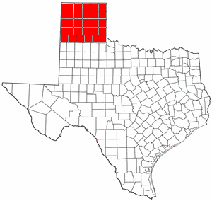
- Brazos ValleyBrazos ValleyThe Brazos Valley is a region in the U.S. state of Texas consisting of Brazos County, Robertson County, Grimes County, Washington County, Burleson County, Madison County, and Leon County, with Brazos County and the cities of College Station and Bryan at its center...
- Central TexasCentral TexasCentral Texas , is a region in the U.S. state of Texas. It is roughly bordered by San Marcos to Fredericksburg to Waco, and to Brenham, and includes the Austin–Round Rock, Killeen-Temple-Fort Hood, Bryan-College Station, and Waco metropolitan areas...
- Texas blackland prairiesTexas blackland prairiesThe Texas Blackland Prairies are a temperate grassland ecoregion located in Texas that runs roughly from the Red River in North Texas to San Antonio in the south.-Setting:...
- The Hill CountryTexas Hill CountryThe Texas Hill Country is a vernacular term applied to a region of Central Texas featuring tall rugged hills consisting of thin layers of soil atop limestone or granite. It also includes the Llano Uplift and the second largest granite monadnock in the United States, Enchanted Rock, which is located...
- Texas blackland prairies
- Gulf Coast
- Galveston BayGalveston BayGalveston Bay is a large estuary located along the upper coast of Texas in the United States. It is connected to the Gulf of Mexico and is surrounded by sub-tropic marshes and prairies on the mainland. The water in the Bay is a complex mixture of sea water and fresh water which supports a wide...
- Greater HoustonGreater HoustonHouston–Sugar Land–Baytown is a 10-county metropolitan area defined by the Office of Management and Budget. It is located along the Gulf Coast region in the U.S. state of Texas...
- Galveston Bay
- East TexasEast TexasEast Texas is a distinct geographic and ecological area in the U.S. state of Texas.According to the Handbook of Texas, the East Texas area "may be separated from the rest of Texas roughly by a line extending from the Red River in north central Lamar County southwestward to east central Limestone...
- Piney WoodsPiney WoodsThe Piney Woods is a temperate coniferous forest terrestrial ecoregion in the Southern United States covering of East Texas, southern Arkansas, western Louisiana, and southeastern Oklahoma. These coniferous forests are dominated by several species of pine as well as hardwoods including hickory and...
- Piney Woods
- North TexasNorth TexasNorth Texas is a distinct cultural and geographic area forming the central-northeastern section of the U.S. state of Texas. North Texas is generally considered to include the area south of Oklahoma, east of Abilene, and north of Waco...
- Dallas – Fort Worth Metroplex
- Texoma
- Rolling Hills
- Northeast TexasNortheast TexasNortheast Texas is a region in the northeast corner of the U.S. state of Texas. It is geographically centered around two metropolitan areas strung along Interstate 20: Tyler in the west and Longview/Marshall to the east...
- Piney WoodsPiney WoodsThe Piney Woods is a temperate coniferous forest terrestrial ecoregion in the Southern United States covering of East Texas, southern Arkansas, western Louisiana, and southeastern Oklahoma. These coniferous forests are dominated by several species of pine as well as hardwoods including hickory and...
- South TexasSouth TexasSouth Texas is a region of the U.S. state of Texas that lies roughly south of and including San Antonio. The southern and western boundary is the Rio Grande River, and to the east it is the Gulf of Mexico. The population of this region is about 3.7 million. The southern portion of this region is...
- Mission Country
- Rio Grande ValleyRio Grande ValleyThe Rio Grande Valley or the Lower Rio Grande Valley, informally called The Valley, is an area located in the southernmost tip of South Texas...
- Southeast TexasSoutheast TexasSoutheast Texas is a subregion of East Texas located in the southeast corner of the U.S. state of Texas. The subregion is geographically centered around the Houston–Sugar Land–Baytown and Beaumont–Port Arthur metropolitan areas...
- Golden TriangleGolden Triangle (Texas)The Golden Triangle is an area of Southeast Texas between the cities of Beaumont, Port Arthur, and Orange. The "golden" refers to the wealth that came from the Spindletop oil strike in Beaumont in 1901...
- Greater HoustonGreater HoustonHouston–Sugar Land–Baytown is a 10-county metropolitan area defined by the Office of Management and Budget. It is located along the Gulf Coast region in the U.S. state of Texas...
- Golden Triangle
- Texas Urban Triangle
- West TexasWest TexasWest Texas is a vernacular term applied to a region in the southwestern quadrant of the United States that primarily encompasses the arid and semi-arid lands in the western portion of the state of Texas....
- Edwards PlateauEdwards PlateauThe Edwards Plateau is a region of west-central Texas which is bounded by the Balcones Fault to the south and east, the Llano Uplift and the Llano Estacado to the north, and the Pecos River and Chihuahuan Desert to the west. San Angelo, Austin, San Antonio and Del Rio roughly outline the area...
- Llano EstacadoLlano EstacadoLlano Estacado , commonly known as the Staked Plains, is a region in the Southwestern United States that encompasses parts of eastern New Mexico and northwestern Texas, including the South Plains and parts of the Texas Panhandle...
- Permian Basin
- South PlainsSouth PlainsSouth Plains is a vernacular term that refers to a region in West Texas consisting of the portion of the Llano Estacado extending south of the Texas Panhandle, centered at Lubbock. While prominent in the area of petroleum production, the South Plains is mainly an agricultural region, producing a...
- Texas PanhandleTexas PanhandleThe Texas Panhandle is a region of the U.S. state of Texas consisting of the northernmost 26 counties in the state. The panhandle is a rectangular area bordered by New Mexico to the west and Oklahoma to the north and east...
(pictured) - Trans-PecosTrans-PecosThe term Trans-Pecos, as originally defined in 1887 by the Texas geologist Robert T. Hill, refers to the portion of Texas that lies west of the Pecos River. The term is considered synonymous with "Far West Texas", a subdivision of West Texas...
- Great PlainsGreat PlainsThe Great Plains are a broad expanse of flat land, much of it covered in prairie, steppe and grassland, which lies west of the Mississippi River and east of the Rocky Mountains in the United States and Canada. This area covers parts of the U.S...
- Edwards Plateau
Utah
- Cache ValleyCache ValleyThe Cache Valley is an agricultural valley of northern Utah and southeast Idaho that includes the Logan metropolitan area. The valley was used by 19th century mountain men and was the site of the 1863 Bear River Massacre.-History:...
- San Rafael SwellSan Rafael SwellThe San Rafael Swell is a large geologic feature located in south-central Utah, USA about 30 miles west of Green River, Utah. The San Rafael Swell, approximately by , consists of a giant dome-shaped anticline of sandstone, shale, and limestone that was pushed up during the Paleocene Laramide...
- Colorado PlateauColorado PlateauThe Colorado Plateau, also called the Colorado Plateau Province, is a physiographic region of the Intermontane Plateaus, roughly centered on the Four Corners region of the southwestern United States. The province covers an area of 337,000 km2 within western Colorado, northwestern New Mexico,...
- DixieDixie (Utah)Dixie is the nickname for southwestern Utah. It was first settled in the early 1860s, when farmers were sent south by Brigham Young to grow cotton, hoping to capitalize on the lack of availability of cotton due to the American Civil War. St. George, Grafton, Duncans Retreat, Adventure, and Northup...
- Great Salt Lake DesertGreat Salt Lake DesertThe Great Salt Lake Desert is a large dry lake in northern Utah between the Great Salt Lake and the Nevada border which is noted for white sand from evaporite Lake Bonneville salt deposits...
- Mojave DesertMojave DesertThe Mojave Desert occupies a significant portion of southeastern California and smaller parts of central California, southern Nevada, southwestern Utah and northwestern Arizona, in the United States...
- Southeastern Utah
- Southwestern Utah
- Uinta MountainsUinta MountainsThe Uinta Mountains are a high chain of mountains in northeastern Utah and extreme northwestern Colorado in the United States. A subrange of the Rocky Mountains, they are unusual for being the highest range in the contiguous United States running east to west, and lie approximately east of Salt...
- Wasatch FrontWasatch FrontThe Wasatch Front is a metropolitan region in the north-central part of the U.S. state of Utah. It consists of a chain of cities and towns stretched along the Wasatch Range from approximately Santaquin in the south to Brigham City in the north...
- Wasatch BackWasatch BackThe Wasatch Back is a region in the Rocky Mountains in the U.S. state of Utah. It includes such cities as Park City, Morgan, Heber City, and Midway. The name Wasatch Back differentiates it from the Wasatch Front, which includes Utah's three most populous cities: Salt Lake City, Ogden, and Provo...
- Wasatch RangeWasatch RangeThe Wasatch Range is a mountain range that stretches approximately from the Utah-Idaho border, south through central Utah in the western United States. It is generally considered the western edge of the greater Rocky Mountains, and the eastern edge of the Great Basin region...
Vermont
- Northeast KingdomNortheast KingdomThe Northeast Kingdom is a term used to describe the northeast corner of the U.S. state of Vermont, comprising Essex, Orleans and Caledonia Counties and having a population of 62,438. In Vermont, the written term "NEK" is often used. The term is attributed to the late George D. Aiken, former...
- Champlain ValleyChamplain ValleyThe Champlain Valley is a region of the United States around Lake Champlain in Vermont and New York extending slightly into Quebec, Canada as part of the St. Lawrence River drainage basin drained northward by the Richelieu River into the St...
- Mount MansfieldMount MansfieldMount Mansfield is the highest mountain in Vermont with a summit that peaks at above sea level. The summit is in Underhill; the ridgeline, including some secondary peaks, extends into the town of Stowe, and the mountain's flanks also reach into the town of Cambridge.When viewed from the east or...
- Green MountainsGreen MountainsThe Green Mountains are a mountain range in the U.S. state of Vermont. The range extends approximately .-Peaks:The most notable mountains in the range include:*Mount Mansfield, , the highest point in Vermont*Killington Peak, *Mount Ellen,...
Virginia
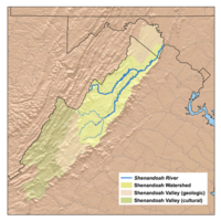
- Tri-Cities, VirginiaTri-Cities, VirginiaThe Tri-Cities of Virginia is an area in the Greater Richmond Region which includes the three independent cities of Petersburg, Colonial Heights, and Hopewell and portions of the adjoining counties of Chesterfield, Dinwiddie, and Prince George in south-central Virginia...
- King GeorgeKing GeorgeKing George has referred to many monarchs and kings throughout history.Bohemia*George of Bohemia, king of BohemiaDuala people of Cameroon*George , king of the Duala peopleGeorgia*George I of Georgia , king of Georgia 1014-1027...
- Eastern ShoreEastern Shore of VirginiaThe Eastern Shore of Virginia consists of two counties on the Atlantic coast of the Commonwealth of Virginia in the United States. The region is part of the Delmarva Peninsula and is separated from the rest of Virginia by the Chesapeake Bay. Its population was 45,553 as of 2010...
- Hampton RoadsHampton RoadsHampton Roads is the name for both a body of water and the Norfolk–Virginia Beach metropolitan area which surrounds it in southeastern Virginia, United States...
- Historic TriangleHistoric TriangleThe Historic Triangle is located on the Virginia Peninsula of the United States and includes the colonial communities of Jamestown, Colonial Williamsburg, and Yorktown, with many restored attractions linked by the Colonial Parkway in James City and York counties and the City of...
- Middle PeninsulaMiddle PeninsulaThe Middle Peninsula is the second of three large peninsulas on the western shore of Chesapeake Bay in Virginia, in the United States. It lies between the Northern Neck and the Virginia Peninsula. This peninsula is bounded by the Rappahannock River on the north and the York River on the south...
- New River ValleyNew River ValleyThe New River Valley is a region in the eastern United States along the New River in the Commonwealth of Virginia . The valley comprises the counties of Montgomery , Pulaski, Floyd, Giles and the independent City of Radford...
- Northern NeckNorthern NeckThe Northern Neck is the northernmost of three peninsulas on the western shore of the Chesapeake Bay in the Commonwealth of Virginia. This peninsula is bounded by the Potomac River on the north and the Rappahannock River on the south. It encompasses the following Virginia counties: Lancaster,...
- Northern VirginiaNorthern VirginiaNorthern Virginia consists of several counties and independent cities in the Commonwealth of Virginia, in a widespread region generally radiating southerly and westward from Washington, D.C...
- Richmond-PetersburgRichmond-PetersburgThe Greater Richmond Region is a region located in a central part of the state of Virginia in the United States. As of 2010, it had a population of 1,258,251, making it the 43rd largest MSA in the country...
(aka Central Virginia) - Shenandoah ValleyShenandoah ValleyThe Shenandoah Valley is both a geographic valley and cultural region of western Virginia and West Virginia in the United States. The valley is bounded to the east by the Blue Ridge Mountains, to the west by the eastern front of the Ridge-and-Valley Appalachians , to the north by the Potomac River...
- South Hampton RoadsSouth Hampton RoadsSouth Hampton Roads is a region located in the extreme southeastern portion of Virginia in the United States, and is part of the Virginia Beach-Norfolk-Newport News, VA-NC MSA with a population about 1.7 million....
- Southside VirginiaSouthside (Virginia)Traditionally, the term Southside refers to the portion of Virginia east of the Blue Ridge Mountains and south of the James River, the geographic feature from which the term derives its name....
- Southwest VirginiaSouthwest VirginiaSouthwest Virginia, often abbreviated as SWVA, is a mountainous region of Virginia in the westernmost part of the commonwealth. Southwest Virginia has been defined alternatively as all Virginia counties on the Appalachian Plateau, all Virginia counties west of the Eastern Continental Divide, or...
- TidewaterTidewater region of VirginiaThe Tidewater region of Virginia is the eastern portion of the Commonwealth of Virginia formally known as Hampton Roads. The term tidewater may be correctly applied to all portions of any area, including Virginia, where the water level is affected by the tides...
- Virginia PeninsulaVirginia PeninsulaThe Virginia Peninsula is a peninsula in southeast Virginia, USA, bounded by the York River, James River, Hampton Roads and Chesapeake Bay.Hampton Roads is the common name for the metropolitan area that surrounds the body of water of the same name...
Washington
- Central WashingtonCentral WashingtonCentral Washington is a region of the United States defined as the western half of Eastern Washington, or those counties lying east of the Cascade Mountains but west of the 119th meridian west....
- Columbia PlateauColumbia PlateauThe Columbia Plateau is a geologic and geographic region that lies across parts of the U.S. states of Washington, Oregon, and Idaho. It is a wide flood basalt plateau between the Cascade Range and the Rocky Mountains, cut through by the Columbia River...
- Eastern WashingtonEastern WashingtonEastern Washington is the portion of the U.S. state of Washington east of the Cascade Range. The region contains the city of Spokane , the Tri-Cities, the Columbia River and the Grand Coulee Dam, the Hanford Nuclear Reservation and the fertile farmlands of the Yakima Valley and the...
- Kitsap PeninsulaKitsap PeninsulaThe Kitsap Peninsula is an arm of land that is part of the larger Olympic Peninsula in Washington state that lies west of Seattle across Puget Sound. Hood Canal separates Kitsap Peninsula from the rest of the Olympic Peninsula...
- Long Beach PeninsulaLong Beach PeninsulaThe Long Beach Peninsula is an arm of land in western Washington state. It is bounded on the west by the Pacific Ocean, the south by the Columbia River, and the east by Willapa Bay...
- Okanogan County
- Olympic PeninsulaOlympic PeninsulaThe Olympic Peninsula is the large arm of land in western Washington state of the USA, that lies across Puget Sound from Seattle. It is bounded on the west by the Pacific Ocean, the north by the Strait of Juan de Fuca, and the east by Puget Sound. Cape Alava, the westernmost point in the contiguous...
- Puget SoundPuget Sound regionThe Puget Sound region is an inland area of the Pacific Northwest in Washington , including Puget Sound, the Puget Sound lowlands, and the surrounding region roughly west of the Cascade Range and east of the Olympic Mountains.- History :...
- San Juan IslandsSan Juan IslandsThe San Juan Islands are an archipelago in the northwest corner of the contiguous United States between the US mainland and Vancouver Island, British Columbia, Canada. The San Juan Islands are part of the U.S...
- Skagit ValleySkagit ValleyThe Skagit Valley lies in the northwestern corner of the state of Washington, USA. Its defining feature is the Skagit River, which snakes through local communities which include the seat of Skagit County, Mount Vernon, as well as Sedro-Woolley, Concrete, Lyman-Hamilton, and Burlington.The local...
- Tri-CitiesTri-Cities, WashingtonThe Tri-Cities is a mid-sized metropolitan area in the southeastern part of the U.S. state of Washington, consisting of three neighboring cities: Kennewick, Pasco, and Richland. The cities are located at the confluence of the Yakima, Snake, and Columbia rivers in the semi-arid region of...
- Walla Walla Valley
- Western WashingtonWestern WashingtonWestern Washington is a region of the United States defined as that part of Washington west of the Cascade Mountains.It is known as being far wetter in climate than the eastern portion of the state, which...
- Yakima ValleyYakima RiverThe Yakima River is a tributary of the Columbia River in south central and eastern Washington State, named for the indigenous Yakama people. The length of the river from headwaters to mouth is , with an average drop of .-Course:...
West Virginia
- Eastern PanhandleEastern Panhandle of West VirginiaThe Eastern Panhandle of West Virginia is a narrow stretch of territory in the northeast of the state, bordering Maryland and Virginia, United States. The Eastern Panhandle Board of Realtors and other local civic organizations consider only the three Easternmost counties, Jefferson, Berkeley and...
- Potomac HighlandsPotomac Highlands of West VirginiaThe Potomac Highlands of West Virginia centers on five counties in the upper Potomac River watershed in the western portion of the state's Eastern Panhandle, bordering Maryland and Virginia...
- Potomac Highlands
- North-Central West VirginiaNorth-Central West VirginiaNorth-Central West Virginia is a region of the U.S. State of West Virginia. The region's largest city is Morgantown.- Counties :*Monongalia County*Marion County*Harrison County*Taylor County*Doddridge County...
- Northern PanhandleNorthern Panhandle of West VirginiaThe Northern Panhandle is a culturally and geographically distinct region in the U.S. state of West Virginia. It is the state's northernmost extension, bounded by the Ohio River on the north and west, along with the state of Pennsylvania on the east...
- Southern West VirginiaSouthern West VirginiaSouthern West Virginia is a culturally and geographically distinct region in the U.S. state of West Virginia. Generally considered the heart of Appalachia, Southern West Virginia is known for its coal mining heritage and southern affinity...
Wisconsin
- Central PlainCentral Plain (Wisconsin)For other central plains, see Central PlainIn the U.S. state of Wisconsin, the Central Plain is a geographical region consisting of about of land in a v-shaped belt across the center of the state...
- Door PeninsulaDoor PeninsulaThe Door Peninsula is a peninsula in eastern Wisconsin, separating the southern part of the Green Bay from Lake Michigan. The peninsula begins in northern Brown and Kewaunee counties and proceeds northeast to include all of Door County. It is the western portion of the Niagara Escarpment. Well...
- Eastern Ridges and LowlandsEastern Ridges and LowlandsThe Eastern Ridges and Lowlands is a geographical region in the eastern part of the U.S. state of Wisconsin, between Green Bay in the north, and the border with Illinois in the south...
- Lake Superior LowlandLake Superior LowlandIn the U.S. state of Wisconsin, the Lake Superior Lowland, also known as the Superior Coastal Plain, is a geographical region located in the far northern part of the state bordering Lake Superior...
- Northern HighlandNorthern HighlandThe Northern Highland is a geographical region covering much of the northern territory of the U.S. state of Wisconsin. The region stretches from the state border with Minnesota in the west to the Michigan border in the east, and from Douglas and Bayfield Counties in the north to Wood and Portage...
- Western UplandWestern UplandThe Western Upland is a geographical region covering much of the western half of the U.S. state of Wisconsin. It stretches from southern Polk County, Wisconsin in the north to the state border with Illinois in the south, and from Rock County in the east to the Mississippi River in the west.The...
See also
- Geography of the United StatesGeography of the United StatesThe United States is a country in the Western Hemisphere. It consists of forty-eight contiguous states in North America, Alaska, a peninsula which forms the northwestern most part of North America, and Hawaii, an archipelago in the Pacific Ocean. There are several United States territories in the...
- Historic regions of the United StatesHistoric regions of the United StatesThis is a list of historic regions of the United States.-Colonial era :-The Thirteen Colonies:* Connecticut Colony* Delaware Colony* Province of Georgia* Province of Maryland...
- Nine Nations of North AmericaNine Nations of North AmericaThe Nine Nations of North America is a book written in 1981 by Joel Garreau. In it, Garreau suggests that North America can be divided into nine regions, or "nations", which have distinctive economic and cultural features...
- Political divisions of the United StatesPolitical divisions of the United StatesThe political units and divisions of the United States include:*The 50 states are subdivided into counties . The counties may be further subdivided into townships, or towns in New York and New England...
- United States metropolitan areaUnited States metropolitan areaIn the United States a metropolitan statistical area is a geographical region with a relatively high population density at its core and close economic ties throughout the area. Such regions are not legally incorporated as a city or town would be, nor are they legal administrative divisions like...
- United States territoryUnited States territoryUnited States territory is any extent of region under the jurisdiction of the federal government of the United States, including all waters including all U.S. Naval carriers. The United States has traditionally proclaimed the sovereign rights for exploring, exploiting, conserving, and managing its...
- U.S. Library of Congress Map of the US Regions