
List of parks in the Baltimore-Washington Metropolitan Area
Encyclopedia
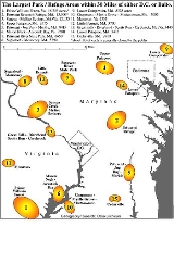
The largest contiguous public parks-preserves within 30 miles (48 km) of either Baltimore, Md. or Washington, D.C.:

Rock Creek Park
, D.C. - 1750 acres (7 km²)
This list does not include interrupted, scattered parts of administrative units, but rather entire, contiguous park-preserve tracts. All contiguous public park-preserve land is included in the above areas, but strip park area (<1000 foot (300 m) width for more than 1/2 mile (800 m)) and public utility land (reservoirs) are excluded.)
Much of the 72500 acres (293 km²) Aberdeen Proving Grounds, Maryland. and 56000 acres (226.6 km²) Quantico Marine Base, Virginia are undeveloped, and constitute the largest such areas within 30 miles (48 km) of either Baltimore or Washington. Neither is generally open to the public. Quantico is contiguous with Prince William Forest Park. Washington and Baltimore are 33 miles (53 km) apart.
- Prince William ForestPrince William Forest ParkPrince William Forest Park was established as Chopawamsic Recreational Demonstration Area in 1936 and is located in southeastern Prince William County, Virginia, adjacent to the Marine Corps Base Quantico. The park is the largest protected natural area in the Washington, D.C. metropolitan region at...
* - Locust Shade, Virginia 18255 acres (74 km²)* — *about one-third is generally closed to the public. - Patuxent Wildlife Research RefugePatuxent Wildlife Research CenterThe Patuxent Wildlife Research Center is a biological research center in Maryland. It is one of only 17 research centers in the United States run by the U.S. Geological Survey. This USGS research center is located on the U.S...
* - Fran Uhler (Patuxent River Park), Maryland 13300 acres (54 km²)* — *about one-third is generally closed to the public. - Seneca CreekSeneca CreekSeneca Creek may refer to some water bodies in the United States:* Seneca Creek , Maryland** Seneca Creek State Park* Seneca Creek , West Virginia...
- McKee-BeshersMcKee-Beshers Wildlife Management AreaMcKee-Beshers Wildlife Management Area is a Wildlife Management Area in Montgomery County, Maryland. Acres of sunflowers are planted each year at McKee-Beshers WMA to attract game birds. Every July, these spectacular fields in full bloom also draw photographers, garden enthusiasts, and...
- C & O CanalChesapeake and Ohio CanalThe Chesapeake and Ohio Canal, abbreviated as the C&O Canal, and occasionally referred to as the "Grand Old Ditch," operated from 1831 until 1924 parallel to the Potomac River in Maryland from Cumberland, Maryland to Washington, D.C. The total length of the canal is about . The elevation change of...
- Germantown, Maryland / Algonkian, VirginiaNorthern Virginia Regional Park AuthorityThe Northern Virginia Regional Park Authority is an interjurisdictional organization that owns and operates more than 10,000 acres of woodlands, streams, parks, trails, nature reserves, countryside and historic sites in Northern Virginia in the United States. The Authority was organized in 1959...
12435 acres (50 km²) - Upper PatapscoPatapsco RiverThe Patapsco River is a river in central Maryland which flows into Chesapeake Bay. The river's tidal portion forms the harbor for the city of Baltimore...
, Maryland 9575 acres (39 km²) - Patuxent River ParkPatuxent RiverThe Patuxent River is a tributary of the Chesapeake Bay in the state of Maryland. There are three main river drainages for central Maryland: the Potomac River to the west passing through Washington D.C., the Patapsco River to the northeast passing through Baltimore, and the Patuxent River between...
- Merkle - Jug Bay WetlandsJug Bay Wetlands SanctuaryThe Jug Bay Wetlands Sanctuary is located along the tidal Patuxent River in southern Maryland. It was established in 1985 and is operated by the Anne Arundel County Department of Recreation and Parks. It includes more than of tidal freshwater wetlands, forests, meadows and fields...
- House Creek, Maryland 8575 acres (35 km²) - Mason Neck - Accotink BayAccotink Bay Wildlife RefugeAccotink Bay Wildlife Refuge is a nature preserve on the grounds of Fort Belvoir in Fairfax County, Virginia, USA. Several other parks, including Mason Neck Park, Pohick Bay Regional Park, and the Jackson Miles Abbott Wetland Refuge are located nearby....
- PohickPohickPohick is a toponym in Northern Virginia derived from the Algonquian word for the "water place." It can refer to:*Pohick , historical Algonquian-speaking tribe, part of Powhatan Confederacy*Pohick language, part of Algonquian family...
- Meadowood - GunstonGunston HallGunston Hall is an 18th-century Georgian mansion near the Potomac River in Mason Neck, Virginia, United States of America. The house was the home of the United States Founding Father George Mason. It was located at the center of a 5500 acre plantation...
**, Virginia 7690 acres (31 km²) - Patuxent River State ParkPatuxent River State ParkPatuxent River State Park is a state park in the state of Maryland. The park is located along the upper reaches of the Patuxent River in Howard and Montgomery Counties. The park features hunting, fishing, hiking and horseback riding.-External links:*...
, Maryland 6650 acres (27 km²) - Sugarloaf Mountain** - Monocacy RiverMonocacy RiverThe Monocacy River is a free-flowing tributary of the Potomac River, which empties into the Atlantic Ocean via the Chesapeake Bay. The river is long, with a drainage area of about...
- C & O Canal, Maryland 5790 acres (23 km²) - Lower Gunpowder FallsGunpowder RiverThe Gunpowder River is a tidal inlet on the western side of Chesapeake Bay in Maryland, United States. It is formed by the joining of two freshwater rivers, Gunpowder Falls and Little Gunpowder Falls.-Gunpowder Falls:The Big Gunpowder, long, begins in the extreme southern part of Pennsylvania's...
, Maryland 5325 acres (22 km²) - ChapmansMount AventineMount Aventine is a farm complex and national historic district located along the Potomac River in Bryans Road, Charles County, Maryland. The complex includes the main house; a second-quarter 19th century Greek Revival-influenced brick house. It was enlarged about 1860 to its present five-bay,...
- Myrtle GroveMyrtle Grove Wildlife Management AreaMyrtle Grove Wildlife Management Area is a Wildlife Management Area in Charles County, Maryland.-External links:*...
- MattawomanMattawoman CreekMattawoman Creek is a coastal-plain tributary to the tidal Potomac River with a mouth at Indian Head, Maryland, downstream of Washington, D.C. It comprises a river flowing through Prince George's and Charles counties and a tidal-freshwater estuary in Charles County...
, Maryland 5305 acres (21 km²) - Manassas BattlefieldManassas National Battlefield ParkManassas National Battlefield Park, located north of Manassas, in Prince William County, Virginia preserves the site of two major American Civil War battles: the First Battle of Bull Run on July 21, 1861, and the Second Battle of Bull Run which was fought between August 28 and August 30, 1862...
, Virginia 4355 acres (18 km²) - Little Bennett, Maryland 3700 acres (15 km²)
- Great FallsGreat Falls ParkGreat Falls Park is a small National Park Service site in Virginia, United States. Situated on 800 acres along the banks of the Potomac River in northern Fairfax County, the park is a disconnected but integral part of the George Washington Memorial Parkway...
, Virginia - C & O CanalChesapeake and Ohio Canal National Historical ParkThe Chesapeake and Ohio Canal National Historical Park is a United States National Historical Park located in the District of Columbia and the states of Maryland and West Virginia. The park was established as a National Monument in 1961 by President Dwight D...
, Maryland - RiverbendPotomac Heritage TrailThe ', also known as the Potomac Heritage National Scenic Trail or the PHT, is a designated National Scenic Trail corridor in the northeastern United States that will connect various trails and historic sites in the states of Virginia, Maryland, and Pennsylvania, and the District of Columbia...
, Virginia - Scotts Run, Virginia - CarderockCarderock, MarylandCarderock, Maryland, is located in Montgomery County, Maryland, along the Potomac River. Carderock is just west of Bethesda.It is the location of a division of the U.S. Naval Surface Warfare Center ....
, Maryland 3440 acres (14 km²) - Lower PatapscoPatapsco RiverThe Patapsco River is a river in central Maryland which flows into Chesapeake Bay. The river's tidal portion forms the harbor for the city of Baltimore...
- Rockburn Branch, Maryland 3435 acres (14 km²) - CedarvilleCedarville State ForestCedarville State Forest is a state forest and protected area in the state of Maryland, near Brandywine, Maryland and Waldorf, Maryland. It offers hiking trails, campsites, and picnic and recreation areas.-External links:...
, Maryland 2848 acres (12 km²) - Smithsonian Environmental Research CenterSmithsonian Environmental Research CenterThe Smithsonian Environmental Research Center is a environmental research and educational facility operated by the Smithsonian Institution. It is located on the Rhode and West Rivers near Edgewater in Anne Arundel County, Maryland, near the western shore of Chesapeake Bay...
** Maryland 2800 acres (11 km²) - limited public access - Upper Gunpowder Falls (Hereford), MarylandGunpowder RiverThe Gunpowder River is a tidal inlet on the western side of Chesapeake Bay in Maryland, United States. It is formed by the joining of two freshwater rivers, Gunpowder Falls and Little Gunpowder Falls.-Gunpowder Falls:The Big Gunpowder, long, begins in the extreme southern part of Pennsylvania's...
2755 acres (11 km²) - Rock Creek Regional (Lake Needwood - North Branch)Lake NeedwoodLake Needwood is a reservoir in Derwood, Maryland just east of Rockville, in the eastern part of Montgomery County that is located on Rock Creek. The lake was created to provide flood control. It also protects the water quality of the creek by functioning as a retention basin to trap sediment from...
2670 acres - Susquehanna State ParkSusquehanna RiverThe Susquehanna River is a river located in the northeastern United States. At long, it is the longest river on the American east coast that drains into the Atlantic Ocean, and with its watershed it is the 16th largest river in the United States, and the longest river in the continental United...
, Maryland 2645 acres (11 km²) - FountainheadNorthern Virginia Regional Park AuthorityThe Northern Virginia Regional Park Authority is an interjurisdictional organization that owns and operates more than 10,000 acres of woodlands, streams, parks, trails, nature reserves, countryside and historic sites in Northern Virginia in the United States. The Authority was organized in 1959...
, Virginia 2450 acres (10 km²) - Nanjemoy Creek**, Maryland 2415 acres (10 km²) - generally closed to the public
- Mid-Gunpowder Falls (Baldwin-Fork)Gunpowder RiverThe Gunpowder River is a tidal inlet on the western side of Chesapeake Bay in Maryland, United States. It is formed by the joining of two freshwater rivers, Gunpowder Falls and Little Gunpowder Falls.-Gunpowder Falls:The Big Gunpowder, long, begins in the extreme southern part of Pennsylvania's...
, Maryland 2300 acres (9 km²) - Eastern NeckEastern Neck National Wildlife RefugeEastern Neck National Wildlife Refuge, a part of the Chesapeake Marshlands National Wildlife Refuge Complex, is a island located at the confluence of the Chester River and the Chesapeake Bay...
, Maryland 2285 acres (9 km²) - Douglas Point - Mallows BayMallows BayMallows Bay is a small bay on the Maryland side of the Potomac River in the United States located at . The bay is the location of what is regarded as the "largest shipwreck fleet in the Western Hemisphere" and is described as a "ship graveyard."...
- Purse State ParkPurse State ParkPurse State Park is a state park in Charles County, Maryland, United States. It is located on the freshwater-tidal Potomac River along Wades Bay. The undeveloped park features hunting, fishing, hiking, bird watching, and fossil hunting....
(Nanjemoy Wildlife Area), Maryland 1920 acres (8 km²) - Soldiers DelightSoldiers DelightSoldiers Delight Natural Environmental Area is a nature reserve near Owings Mills in western Baltimore County, Maryland, USA. The site is designated both a Maryland Wildland and a Natural Environment Area and is part of the Maryland Wildlands Preservation System...
, Maryland 1920 acres (8 km²)
Rock Creek Park
Rock Creek Park
Rock Creek Park is a large urban natural area with public park facilities that bisects Washington, D.C. The park is administered by the National Park Service.-Rock Creek Park:The main section of the park contains , or , along the Rock Creek Valley...
, D.C. - 1750 acres (7 km²)
- ** quasi-public
This list does not include interrupted, scattered parts of administrative units, but rather entire, contiguous park-preserve tracts. All contiguous public park-preserve land is included in the above areas, but strip park area (<1000 foot (300 m) width for more than 1/2 mile (800 m)) and public utility land (reservoirs) are excluded.)
Much of the 72500 acres (293 km²) Aberdeen Proving Grounds, Maryland. and 56000 acres (226.6 km²) Quantico Marine Base, Virginia are undeveloped, and constitute the largest such areas within 30 miles (48 km) of either Baltimore or Washington. Neither is generally open to the public. Quantico is contiguous with Prince William Forest Park. Washington and Baltimore are 33 miles (53 km) apart.
External links
- Prince William Forest Park
- Locust Shade Park
- Patuxent Wildlife Research Refuge
- Fran Uhler Natural Area
- Seneca Creek State Park
- McKee Beshers Wildlife Area
- Chesapeake and Ohio Canal
- South Germantown Park
- Algonkian Park
- Patapsco Valley State Park
- Patuxent River Park
- Merkle Wildlife Sanctuary
- Jug Bay Wetlands Sanctuary
- Mason Neck
- Pohick Bay Park
- Gunston Hall
- Meadowood Recreation Area
- Patuxent River State Park
- Sugarloaf Mountain
- Monocacy Wildlife Area
- Gunpowder Falls State Park
- Chapman Forest
- Chapman Forest
- Myrtle Grove Wildlife Area
- Mattawoman Natural Area
- Manassas Battlefield
- Little Bennett Park
- Great Falls, Va.
- Great Falls Park, Va.
- Riverbend Park
- Scotts Run Preserve
- Carderock Recreation Area
- Rockburn Branch Park
- Cedarville State Forest
- Smithsonian Environmental Research Center
- Rock Creek Park, Md.
- Susquehanna State Park
- Fountainhead Park
- North Branch Park
- Nanjemoy Creek Preserve
- Eastern Neck Wildlife Refuge
- Douglas Point/Mallows Bay (Nanjemoy Wildlife Area)
- Douglas Point/Mallows Bay (Nanjemoy Wildlife Area)
- Purse State Park
- Soldiers Delight Natural Area
- Rock Creek Park, D.C.
- Aberdeen Proving Grounds
- Quantico Marine Base