

List of national parks of Italy
Encyclopedia
National park
A national park is a reserve of natural, semi-natural, or developed land that a sovereign state declares or owns. Although individual nations designate their own national parks differently A national park is a reserve of natural, semi-natural, or developed land that a sovereign state declares or...
s cover about five percent of the country. The parks are managed by the Ministry of the Environment .
List of Italian national parks
| Name | Regions | Area | High Point | Elevation | Map | Quick View |
|---|---|---|---|---|---|---|
| Abruzzo, Lazio e Molise | Abruzzo Abruzzo Abruzzo is a region in Italy, its western border lying less than due east of Rome. Abruzzo borders the region of Marche to the north, Lazio to the west and south-west, Molise to the south-east, and the Adriatic Sea to the east... , Lazio, Molise Molise Molise is a region of Southern Italy, the second smallest of the regions. It was formerly part of the region of Abruzzi e Molise and now a separate entity... |
506.83 km² (195.7 sq mi) | Monte Petroso Monti della Meta The Monti della Meta are a massif of central Italy located around the junction point of the boundaries between the regions of Lazio, Abruzzo and Molise. The major of three massifs of the Parco Nazionale d'Abruzzo, Lazio e Molise, they take their name from one of the peaks, Monte Meta... |
2249 m (7,378.6 ft) | ||
| Alta Murgia Alta Murgia National Park The Parco Nazionale dell'Alta Murgia is a national park in Apulia, southern Italy. It lies in the Murgia geographical area. It was instituted in 2004, with an area of 677.39 km². The seat is in Gravina in Puglia.-External links:***... |
Puglia (Apulia) | 677.39 km² (261.5 sq mi) | Torre Disperata | 686 m (2,250.7 ft) | ||
| Appennino Lucano - Val d'Agri - Lagonegrese Lucania Lucania was an ancient district of southern Italy, extending from the Tyrrhenian Sea to the Gulf of Taranto. To the north it adjoined Campania, Samnium and Apulia, and to the south it was separated by a narrow isthmus from the district of Bruttium... |
Basilicata Basilicata Basilicata , also known as Lucania, is a region in the south of Italy, bordering on Campania to the west, Apulia to the north and east, and Calabria to the south, having one short southwestern coastline on the Tyrrhenian Sea between Campania in the northwest and Calabria in the southwest, and a... |
689.96 km² (266.4 sq mi) | Monte del Papa | 2005 m (6,578.1 ft) | ||
| Appennino Tosco-Emiliano Appennino Tosco-Emiliano National Park Appennino Tosco-Emiliano National Park is a state-held natural preserve in central Italy, located in the heart of an area noted for natural features and for the local quality products and handicrafts. It was founded in 2001, and is included in the provinces of Massa, Lucca, Reggio Emilia and... |
Emilia-Romagna Emilia-Romagna Emilia–Romagna is an administrative region of Northern Italy comprising the two historic regions of Emilia and Romagna. The capital is Bologna; it has an area of and about 4.4 million inhabitants.... , Toscana |
227.92 km² (88 sq mi) | Monte Cusna Monte Cusna Monte Cusna is a mountain in the northern Apennines, located in the trait between the Cerreto and Lagastrello Passes, with an altitude of . The mountain is also known as Uomo Morto , "Uomo che Dorme" or "Il Gigante" for its appearance, resembling a lying man.The peak is situated in the... |
2121 m (6,958.7 ft) | ||
| Sardegna (Sardinia) | 201.46 km² (77.8 sq mi) | Punta Tejalone, | 212 m (695.5 ft) | |||
| Arcipelago Toscano Arcipelago Toscano National Park Arcipelago Toscano National Park is a large marine park in Italy: it safeguards 56,766 hectares of sea and 17,887 hectares of land. It includes the seven main islands of the Archipelago , some minor islands and cliffs.-References:* Yearbook of the Italian Parks 2005, edited by Comunicazione in... |
Toscana | 746.53 km² (288.2 sq mi) | Monte Capanne on Elba Elba Elba is a Mediterranean island in Tuscany, Italy, from the coastal town of Piombino. The largest island of the Tuscan Archipelago, Elba is also part of the National Park of the Tuscan Archipelago and the third largest island in Italy after Sicily and Sardinia... in the Tuscan Archipelago Tuscan Archipelago The Tuscan Archipelago is a chain of islands between the Ligurian Sea and Tyrrhenian Sea, west of Tuscany, Italy.The archipelago contains the islands of Gorgona, Capraia, Elba , Pianosa, Montecristo, Giglio, and Giannutri; all of which are protected as part of the Tuscan Archipelago National... |
1018 m (3,339.9 ft) | 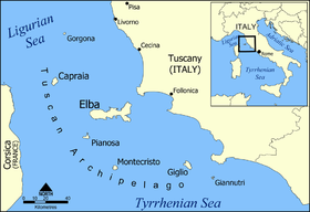 |
|
| Asinara Asinara National Park Asinara is the third largest island of Sardinia after Sant'Antioco. It houses a great variety of habitats. The island has an extremely peculiar historical, environmental, and juridical situation... |
Sardegna (Sardinia) | 269.6 km² (104.1 sq mi) | Punta Scomunica | 408 m (1,338.6 ft) | 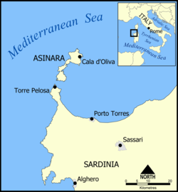 |
 |
| Aspromonte Aspromonte National Park Aspromonte National Park is situated in the southern section of the Apennines, in Calabria, Italy.The park lies near the sea and includes mountain summits nearly reaching the 2,000 meters of height .... |
Calabria Calabria Calabria , in antiquity known as Bruttium, is a region in southern Italy, south of Naples, located at the "toe" of the Italian Peninsula. The capital city of Calabria is Catanzaro.... |
760.53 km² (293.6 sq mi) | Montalto Montalto (Aspromonte) The Montalto is the highest peak of the Aspromonte, a massif in southern Calabria, southern Italy. Located near Gambarie, in the province of Reggio Calabria, it has an altitude of . It is also part of the Aspromonte National Park.... |
1955 m (6,414 ft) | 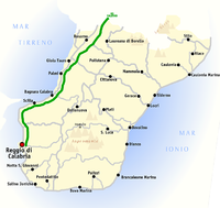 |
|
| Campania Campania Campania is a region in southern Italy. The region has a population of around 5.8 million people, making it the second-most-populous region of Italy; its total area of 13,590 km² makes it the most densely populated region in the country... |
1810.48 km² (699 sq mi) | Monte Cervati | 1898 m (6,227 ft) |  |
||
| Cinque Terre Parco Nazionale delle Cinque Terre The Cinque Terre National Park is a protected area inducted as a national park in 1999, located in the province of La Spezia, Liguria, northern Italy... |
Liguria Liguria Liguria is a coastal region of north-western Italy, the third smallest of the Italian regions. Its capital is Genoa. It is a popular region with tourists for its beautiful beaches, picturesque little towns, and good food.-Geography:... |
38.6 km² (14.9 sq mi) | Monte (Mai-)Pertuso | 820 m (2,690.3 ft) | ||
| Circeo Mount Circeo Monte Circeo or Cape Circeo is a mountain remaining as a promontory that marks the southwestern limit of the former Pontine Marshes. Although a headland, it was not formed by coastal erosion–as headlands are usually formed–but is a remnant of the orogenic processes that created the... |
Lazio | 84.4 km² (32.6 sq mi) | Monte Circeo | 541 m (1,774.9 ft) | ||
| Dolomiti Bellunesi Dolomites The Dolomites are a mountain range located in north-eastern Italy. It is a part of Southern Limestone Alps and extends from the River Adige in the west to the Piave Valley in the east. The northern and southern borders are defined by the Puster Valley and the Sugana Valley... |
Veneto Veneto Veneto is one of the 20 regions of Italy. Its population is about 5 million, ranking 5th in Italy.Veneto had been for more than a millennium an independent state, the Republic of Venice, until it was eventually annexed by Italy in 1866 after brief Austrian and French rule... |
315.12 km² (121.7 sq mi) | Monte Pavione | 2335 m (7,660.8 ft) |  |
|
| Foreste Casentinesi, Monte Falterona, Campigna Foreste Casentinesi, Monte Falterona, Campigna National Park The Parco Nazionale delle Foreste Casentinesi, Monte Falterona, Campigna is a national park in Italy. Created in 1993, it covers an area of about 365 square kilometres , on the two sides of the Apennine watershed between Romagna and Tuscany, and is divided between the provinces of Forlì Cesena,... |
Emilia-Romagna Emilia-Romagna Emilia–Romagna is an administrative region of Northern Italy comprising the two historic regions of Emilia and Romagna. The capital is Bologna; it has an area of and about 4.4 million inhabitants.... , Toscana |
364 km² (140.5 sq mi) | Monte Falterona Monte Falterona Monte Falterona is a mountain in the Tuscan-Romagnolo Apeninnes, in the Casentino traditional region, standing at 1,654 m. It is part of the Casentino forests, Monte Falterona and Campigna National Park.... |
1645 m (5,397 ft) | ||
| Gargano Gargano National Park The Gargano National Park is a national park in the province of Foggia, southern Italy. Aside from the Mount Gargano promontory from which it takes its name, it includes also the Tremiti Islands archipelago and the Foresta Umbra, a large wood protected area established in 1977.... |
Puglia (Apulia) | 1211.18 km² (467.6 sq mi) | Monte Calvo | 1065 m (3,494.1 ft) | ||
| Gennargentu Gennargentu National Park The Gennargentu National Park is a national park on the east coast of Sardinia.... |
Sardegna (Sardinia) | 730 km² (281.9 sq mi) | Punta La Marmora Punta La Marmora Punta La Marmora is a mountain in the Gennargentu range, Ogliastra and Nuoro provinces, Sardinia, Italy in the Barbagia mountain area of inner Sardinia . With its summit at an elevation of 1,834 m, it is the highest peak in the island... |
1834 m (6,017.1 ft) | 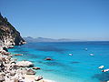 |
|
| Gran Paradiso Gran Paradiso National Park Gran Paradiso National Park is an Italian national park in the Graian Alps, between the Aosta Valley and Piedmont regions. The park is named after Gran Paradiso mountain, which is located in the park... |
Valle d'Aosta, Piemonte | 700 km² (270.3 sq mi) | Gran Paradiso Gran Paradiso The Gran Paradiso is a mountain group between the Aosta Valley and Piedmont regions of north-west Italy. The peak, the 7th highest mountain in the Graian Alps with an elevation of 4,061 m, is close to Mont Blanc on the nearby border with France. On the French side of the border, the park is... |
4061 m (13,323.5 ft) | ||
| Gran Sasso e Monti della Laga Gran Sasso e Monti della Laga National Park The Gran Sasso and Monti della Laga National Park is a natural park in Italy, which was established in 1991. It has an area of 2,014 square kilometres... |
Marche Marche The population density in the region is below the national average. In 2008, it was 161.5 inhabitants per km2, compared to the national figure of 198.8. It is highest in the province of Ancona , and lowest in the province of Macerata... , Abruzzo Abruzzo Abruzzo is a region in Italy, its western border lying less than due east of Rome. Abruzzo borders the region of Marche to the north, Lazio to the west and south-west, Molise to the south-east, and the Adriatic Sea to the east... , Lazio |
1413.31 km² (545.7 sq mi) | Corno Grande Corno Grande Corno Grande is part of the Gran Sasso massif, and is the highest peak in the Apennine Mountains and the highest on the Italian Peninsula, at 2,912 m above sea level.... |
2912 m (9,553.8 ft) | 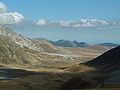 |
|
| Majella Majella National Park The Majella National Park is a national park located in the provinces of Chieti, Pescara and L'Aquila, in the region Abruzzo, Italy.... |
Abruzzo Abruzzo Abruzzo is a region in Italy, its western border lying less than due east of Rome. Abruzzo borders the region of Marche to the north, Lazio to the west and south-west, Molise to the south-east, and the Adriatic Sea to the east... |
628.38 km² (242.6 sq mi) | Monte Amaro Majella The Maiella is a massif in the Central Apennines, in Abruzzo, central Italy, at the boundary between the provinces of Chieti, Pescara and L'Aquila.... |
2793 m (9,163.4 ft) | 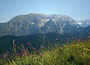 |
|
| Monti Sibillini | Marche Marche The population density in the region is below the national average. In 2008, it was 161.5 inhabitants per km2, compared to the national figure of 198.8. It is highest in the province of Ancona , and lowest in the province of Macerata... , Umbria Umbria Umbria is a region of modern central Italy. It is one of the smallest Italian regions and the only peninsular region that is landlocked.Its capital is Perugia.Assisi and Norcia are historical towns associated with St. Francis of Assisi, and St... |
697.22 km² (269.2 sq mi) | Monte Vettore Monte Vettore Monte Vettore is a mountain on the border between Umbria and the Marche, in central Italy. It is part of the Sibillini mountains range and lies in the Parco Nazionale dei Monti Sibillini. Today climbers reach it from the Umbrian side from Norcia, or, on the Marche side, from Ascoli Piceno... |
2476 m (8,123.4 ft) | ||
| Pollino Pollino National Park The Pollino National Park is a national park in Basilicata and Calabria, southern Italy. Comprised within the provinces of Cosenza, Matera and Potenza, with its 1,820 square kilometres it is the largest natural park in the country... |
Basilicata Basilicata Basilicata , also known as Lucania, is a region in the south of Italy, bordering on Campania to the west, Apulia to the north and east, and Calabria to the south, having one short southwestern coastline on the Tyrrhenian Sea between Campania in the northwest and Calabria in the southwest, and a... , Calabria Calabria Calabria , in antiquity known as Bruttium, is a region in southern Italy, south of Naples, located at the "toe" of the Italian Peninsula. The capital city of Calabria is Catanzaro.... |
1711.32 km² (660.7 sq mi) | Sierra Dolcedorme | 2267 m (7,437.7 ft) | ||
| Sila Sila National Park Sila National Park was established in 1997 and covers about 74,000 ha of charming and wild areas in Calabria. Besides offering exciting landscapes stretching out towards Pollino, Aspromonte, Etna, the Ionian and Tyrrhenian Sea, it is also characterized by the presence of several rural and tourist... |
Calabria Calabria Calabria , in antiquity known as Bruttium, is a region in southern Italy, south of Naples, located at the "toe" of the Italian Peninsula. The capital city of Calabria is Catanzaro.... |
736.95 km² (284.5 sq mi) | Monte Botte Donato | 1928 m (6,325.5 ft) | ||
| Stelvio Stelvio National Park Stelvio National Park is a national park in the north-east of Italy, founded in 1935.The park is the largest in Italy and covers part of two regions: Trentino-Alto Adige/Südtirol and Lombardia, in 24 municipalities.... |
Lombardia, Trentino-Alto Adige/Südtirol | 1307 km² (504.6 sq mi) | Cima Ortles Ortler Ortler is, at above sea level, the highest mountain in the Eastern Alps outside the Bernina Range. It is the main peak of the Ortler Range. It is the highest point of the Southern Limestone Alps, of the Italian province of South Tyrol, of Tyrol overall, and, until 1919, of the Austrian-Hungarian... |
3905 m (12,811.7 ft) | ||
| Val Grande Ossola The Ossola is an area of Italy situated to the north of Lago Maggiore. It lies within the Province of Verbano-Cusio-Ossola. Its principal river is the Toce, and its most important town Domodossola.... |
Piemonte | 145.98 km² (56.4 sq mi) | Monte Togano | 2295 m (7,529.5 ft) | ||
| Vesuvius Vesuvius National Park Vesuvius National Park is a national park centered around the volcano, Mount Vesuvius, east of Naples, Italy. The park was founded in 1995 and covers an area of around 135 square kilometers all located within the Province of Naples.... |
Campania Campania Campania is a region in southern Italy. The region has a population of around 5.8 million people, making it the second-most-populous region of Italy; its total area of 13,590 km² makes it the most densely populated region in the country... |
72.59 km² (28 sq mi) | Great Cone | 1281 m (4,202.8 ft) | 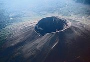 |
See also
- Conservation in ItalyConservation in Italy-Conservation organisation:*Lega italiana protezione uccelli *Italia Nostra...
- List of conservation topics
- List of regional parks of Italy