

List of land borders by date of establishment
Encyclopedia
This list of land borders with date of establishment identifies the historical year in which borders were established between countries.
Albania-Greece
Albania-Montenegro
Albania-Republic of Macedonia
Albania-Serbia
Andorra-Spain
Austria-Czech Republic
Austria-Liechtenstein
Austria-Switzerland
Austria-Slovakia
Austria-Hungary
Austria-Slovenia
Austria-Germany
Austria-Italy
Azerbaijan-Georgia
Azerbaijan-Russia
Belarus-Latvia
Belarus-Poland
Belarus-Russia
Belarussia-Ukraine
Belgium-Netherlands
Belgium-France
Belgium-Luxembourg
Belgium-Germany
Bosnia and Hercegovina-Croatia
Bosnia and Hercegovina-Montenegro
Bosnia and Hercegovina-Serbia
Bulgaria-Greece
Bulgaria-Republic of Macedonia
Bulgaria-Romania
Bulgaria-Serbia
Bulgaria-Turkey
Croatia-Hungary
Croatia-Montenegro
Croatia-Serbia
Croatia-Slovenia
Czech Republic-Germany
Czech Republic-Poland
Czech Republic-Slovakia
Denmark-Germany
Denmark-Sweden
Estonia-Latvia
Estonia-Russia
Finland-Sweden
Finland-Norway
Finland-Russia
France-Switzerland
France-Italy
France-Monaco
France-Spain
France-Germany
France-Luxembourg
France-UK
Georgia-Russia
Germany-Luxembourg
Germany-Netherlands
Germany-Poland
Germany-Switzerland
Greece-Republic of Macedonia
Greece-Turkey
Hungary-Romania
Hungary-Slovakia
Hungary-Serbia
Hungary-Slovenia
Hungary-Ukraine
Italy-San Marino
Italy-Slovenia
Italy-Switzerland
Italy-Vatican City
Ireland-UK
Latvia-Lithuania
Lithuania-Belarus
Lithuania-Poland
Lithuania-Russia
Latvia-Russia
Liechtenstein-Switzerland
Republic of Macedonia-Serbia
Moldova-Romania
Moldova-Ukraine
Montenegro-Serbia
Norway-Russia
Norway-Sweden
Poland-Slovakia
Poland-Russia
Poland-Ukraine
Portugal-Spain
Romania-Ukraine
Romania-Serbia
Russia-Ukraine
Slovakia-Ukraine
Spain-UK
Afghanistan-Iran
Afghanistan-Pakistan
Afghanistan-Tajikistan
Afghanistan-Turkmenistan
Afghanistan-Uzbekistan
Armenia-Azerbaijan
Armenia-Georgia
Armenia-Turkey
Azerbaijan-Iran
Azerbaijan-Turkey
Bangladesh-Burma
Bangladesh-India
Bhutan-India
Bhutan-China
Brunei-Malaysia
Burma-India
Burma-China
Burma-Thailand
Cambodia-Laos
Cambodia-Thailand
Cambodia-Vietnam
China-Laos
China-Pakistan
China-India
China-Kazakhstan
China-Kyrgyzstan
China-Mongolia
China-Nepal
China-North Korea
China-Tajikistan
China-Russia
China-Vietnam
East Timor-Indonesia
Egypt-Israel
Georgia-Turkey
India-Nepal
India-Pakistan
Indonesia-Malaysia
Iran-Iraq
Iran-Pakistan
Iran-Turkey
Iran-Turkmenistan
Iraq-Jordan
Iraq-Kuwait
Iraq-Saudi Arabia
Iraq-Syria
Iraq-Turkey
Israel-Syria
Israel-Jordan
Jordan-Syria
Jordan-Saudi Arabia
Kazakhstan-Kyrgyzstan
Kazakhstan-Russia
Kazakhstan-Turkmenistan
Kazakhstan-Uzbekistan
Kuwait-Saudi Arabia
Kyrgyzstan-Tajikistan
Kyrgyzstan-Uzbekistan
Laos-Burma
Laos-Thailand
Laos-Vietnam
Lebanon-Syria
Lebanon-Israel
Malaysia-Singapore
Malaysia-Thailand
Mongolia-Russia
North Korea-South Korea
North Korea-Russia
Oman-Saudi Arabia
Oman-United Arab Emirates
Oman-Yemen
Saudi Arabia-Qatar
Saudi Arabia-United Arab Emirates
Saudi Arabia-Yemen
Syria-Turkey
Tajikistan-Uzbekistan
Turkmenistan-Uzbekistan
Algeria-Mali
Algeria-Mauritania
Algeria-Morocco
Algeria-Niger
Algeria-Tunisia
Angola-Democratic Republic of the Congo
Angola-Namibia
Angola-Republic of the Congo
Angola-Zambia
Benin-Burkina Faso
Benin-Niger
Benin-Nigeria
Burkina Faso-Togo
Burkina Faso-Ghana
Burkina Faso-Côte d'Ivoire
Burkina Faso-Mali
Burkina Faso-Niger
Botswana-South Africa
Botswana-Zimbabwe
Botswana-Namibia
Burundi-Democratic Republic of the Congo
Burundi-Rwanda
Burundi-Tanzania
Cameroon-Central African Republic
Cameroon-Republic of the Congo
Central African Republic-Republic of the Congo
Central African Republic-Democratic Republic of the Congo
Central African Republic-Chad
Cameroon-Gabon
Cameroon-Equatorial Guinea
Cameroon-Chad
Cameroon-Nigeria
Chad-Libya
Chad-Niger
Chad-Nigeria
Central African Republic-Sudan
Chad-Sudan
Côte d'Ivoire-Mali
Côte d'Ivoire-Guinea
Côte d'Ivoire-Liberia
Democratic Republic of the Congo-Sudan
Democratic Republic of the Congo-Republic of the Congo
Democratic Republic of the Congo-Rwanda
Democratic Republic of the Congo-Uganda
Democratic Republic of the Congo-Zambia
Djibouti-Eritrea
Djibouti-Ethiopia
Djibouti-Somalia
Egypt-Libya
Egypt-Sudan
Equatorial Guinea-Gabon
Eritrea-Sudan
Eritrea-Ethiopia
Ethiopia-Kenya
Ethiopia-Sudan
Ethiopia-Somalia
Gabon-Republic of the Congo
The Gambia-Senegal
Ghana-Togo
Ghana-Côte d'Ivoire
Guinea-Liberia
Guinea-Sierra Leone
Guinea-Mali
Guinea-Senegal
Guinea-Guinea-Bissau
Guinea-Bissau-Senegal
Kenya-Sudan
Kenya-Somalia
Kenya-Uganda
Kenya-Tanzania
Lesotho-South Africa
Libya-Niger
Libya-Sudan
Libya-Tunisia
Liberia-Sierra Leone
Mali-Senegal
Mali-Mauritania
Malawi-Mozambique
Mali-Niger
Malawi-Tanzania
Malawi-Zambia
Mauritania-Senegal
Morocco-Spain
Mozambique-South Africa
Mozambique-Swaziland
Mozambique-Tanzania
Mozambique-Zambia
Mozambique-Zimbabwe
Namibia-Zambia
Namibia-South Africa
Niger-Nigeria
Rwanda-Tanzania
Rwanda-Uganda
Sudan-Uganda
South Africa-Swaziland
South Africa-Zimbabwe
Tanzania-Uganda
Tanzania-Zambia
Zambia-Zimbabwe

Belize-Guatemala
Belize-Mexico
Canada-United States
Costa-Rica-Panama
Costa Rica-Nicaragua
Dominican Republic-Haiti
El Salvador-Guatemala
El Salvador-Honduras
France-Netherlands
Guatemala-Honduras
Guatemala-Mexico
Honduras-Nicaragua
Mexico-United States
 Argentina
-Brazil
Argentina-Bolivia
Argentina-Chile
Argentina-Paraguay
Argentina-Uruguay
Bolivia-Brazil
Bolivia-Chile
Bolivia-Paraguay
Bolivia-Peru
Brazil-Colombia
Brazil-France
Brazil-Guyana
Brazil-Paraguay
Brazil-Peru
Brazil-Suriname
Brazil-Uruguay
Brazil-Venezuela
Colombia-Ecuador
Colombia-Panama
Colombia-Peru
Colombia-Venezuela
Ecuador-Peru
France-Suriname
Guyana-Suriname
Guyana-Venezuela
Algeria-Western Sahara
Mauritania-Western Sahara
Morocco-Western Sahara
Egypt-Palestinian Territories
Israel-Palestinian Territories
Jordan-Palestinian Territories
Europe
Andorra-France-
- 985 France doesn't help Barcelona versus the Saracens, border between France and Barcelona.
- 1278 FoixFoixFoix is a commune, the capital of the Ariège department in southwestern France. It is the least populous administrative centre of a department in all of France, although it is only very slightly smaller than Privas...
gains co-sovereignty over Andorra next to the bishop of Urgel.
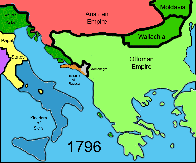
Albania-Greece
-
- 1913/1914 after Greek withdrawal due to international diplomatic pressure.
Albania-Montenegro
- ShkodërShkodërShkodër , is a city located on Lake of Shkoder in northwestern Albania in the District of Shkodër, of which it is the capital. It is one of the oldest and most historic towns in Albania, as well as an important cultural and economic centre. Shkodër's estimated population is 90,000; if the...
- BeraneBeraneBerane , formerly Ivangrad, is a town in north-eastern Montenegro. It has a population of 11,776 .Berane is the centre of municipality and one of the centres of Polimlje area, named after the Lim River, on which Berane is situated.-History:During the medieval period the Montenegrin land of Berane...
- 1913 at the treaty of London.
- From ShkodërShkodërShkodër , is a city located on Lake of Shkoder in northwestern Albania in the District of Shkodër, of which it is the capital. It is one of the oldest and most historic towns in Albania, as well as an important cultural and economic centre. Shkodër's estimated population is 90,000; if the...
- PodgoricaPodgoricaPodgorica , is the capital and largest city of Montenegro.Podgorica's favourable position at the confluence of the Ribnica and Morača rivers and the meeting point of the fertile Zeta Plain and Bjelopavlići Valley has encouraged settlement...
to ShkodërShkodërShkodër , is a city located on Lake of Shkoder in northwestern Albania in the District of Shkodër, of which it is the capital. It is one of the oldest and most historic towns in Albania, as well as an important cultural and economic centre. Shkodër's estimated population is 90,000; if the...
- UlcinjUlcinjUlcinj is a coastal resort town and municipality in Montenegro. The town of Ulcinj has a population of 10,828 of which the majority are Albanians...
- 1878 at the treaty of Berlin, border between Montenegro and the Ottoman Empire.
- 1913 at the treaty of London.
Albania-Republic of Macedonia
-
- 1913 at the treaty of London, border between Albania and Serbia.
- 1991 Independence for the Republic of Macedonia.
Albania-Serbia
-
- 1913 at the treaty of London.
Andorra-Spain
-
- 1278 Foix gains co-sovereignty over Andorra next to the bishop of Urgel.
- 1479 Union between Castile and Aragon, the beginning of Spain.
Austria-Czech Republic
-
- 12th/13th century, region settled by Germans, border between Austria and Bohemia (Czech Republic).
Austria-Liechtenstein
-
- 1719 Creation of Liechtenstein.
Austria-Switzerland
- Stuben - ScuolScuolScuol is a municipality in the district of Inn in the Swiss canton of Graubünden. The official language in Scuol is Romansh.-Name:The official name has undergone several changes in the 20th century:...
- 1363 Tyrol becomes Austrian, border between Austria and the bishopric of Chur.
- 1497/1498 Grissons allies with Switzerland.
- SchrunsSchrunsSchruns is the main village of the Montafon valley in Vorarlberg, Austria, in the Bludenz district.In the west, one can see one of the most popular hiking and climbing mountains in Vorarlberg, the Zimba, which is called the "Vorarlberger Matterhorn"....
- DavosDavosDavos is a municipality in the district of Prättigau/Davos in the canton of Graubünden, Switzerland. It has a permanent population of 11,248 . Davos is located on the Landwasser River, in the Swiss Alps, between the Plessur and Albula Range...
- 1420 Austria acquires Montafon, border between Austria and Toggenburg.
- 1497/1498 Grissons allies with Switzerland.
- BregenzBregenz-Culture:The annual summer music festival Bregenzer Festspiele is a world-famous festival which takes place on and around a stage on Lake Constance, where a different opera is performed every second year.-Sport:* A1 Bregenz HB is a handball team....
- St. GallenSt. GallenSt. Gallen is the capital of the canton of St. Gallen in Switzerland. It evolved from the hermitage of Saint Gall, founded in the 7th century. Today, it is a large urban agglomeration and represents the center of eastern Switzerland. The town mainly relies on the service sector for its economic...
- 15th century, Austria becomes the dominant power on the east bank of the Rhine.
- 1491 Switzerland takes control of the west bank of the Rhine.
Austria-Slovakia
-
- 976 Babenberger receive the Eastmark from the German king, border between Austria and Hungary.
- 1993 Slovakian independence.
Austria-Hungary
-
- 1919 at the treaty of Saint-Germain.
Austria-Slovenia
-
- 1919 at the treaty of Saint-Germain, border between Austria and Yugoslavia.
- 1991 Slovenian independence.
Austria-Germany
-
- 1871 establishment of the German Empire, border between Austria-Hungary and Germany.
Austria-Italy
- From NaudersNaudersNauders is a municipality in the district of Landeck in Tyrol, Austria. It can be found 29 km south of the city of Landeck. As it is near both the Italian and Swiss borders, at the end of World War II numerous Nazi officials fled through Nauders to escape arrest.-External links:...
- MalsMalsMals is a comune in South Tyrol in the Italian region Trentino-Alto Adige/Südtirol, located about 80 km northwest of Trento and about 70 km northwest of Bolzano, on the border with Switzerland and Austria.-Geography:...
to LienzLienzLienz is a medieval town in the Austrian state of Tyrol. It is the administrative centre of the Lienz district, which covers all of East Tyrol. The municipality also includes the cadastral subdivision of Patriasdorf.-Geography:...
- BruneckBruneckBruneck is the largest town in the Puster Valley in the Italian province of South Tyrol. Bruneck lies at the confluence of the Ahr with the Rienz Bruneck is the largest town in the Puster Valley in the Italian province of South Tyrol. Bruneck lies at the confluence of the Ahr with the Rienz...
- 1919 at the treaty of Saint-Germain.
- Kötschach - PaluzzaPaluzzaPaluzza is a comune in the Province of Udine in the Italian region Friuli-Venezia Giulia, located about 120 km northwest of Trieste and about 50 km northwest of Udine, in the Carnia, on the border with Austria....
- 1st millennium, border between Italy and Carinthia.
- 1335 Carinthia is inherited by the duke of Austria, border between Austria and Aquileia.
- 1866 Venice conquered by Italy from Austria.
- VillachVillachVillach is the second largest city in the Carinthia state in the southern Austria, at the Drava River and represents an important traffic junction for Austria and the whole Alpe-Adria region. , the population is 58,480.-History:...
- TarvisioTarvisioTarvisio is a town in the Province of Udine, in the northeastern part of the autonomous Friuli–Venezia Giulia region in Italy...
- 1919 at the treaty of Saint-Germain.
Azerbaijan-Georgia
-
- 1991 Azerbaijani and Georgian independence.
Azerbaijan-Russia
-
- 1991 dissolvement of the Soviet Union.
Belarus-Latvia
-
- 1920 peace between Latvia/Poland and the Soviet Union, border between Latvia and the Soviet Union/Poland.
- 1991 Belarussian and Latvian independence.
Belarus-Poland
-
- 1945 after the annexation of East Poland by Stalin, border between Poland and the Soviet Union.
- 1991 Belarussian independence.
Belarus-Russia
- From PolatskPolatskPolotsk , is a historical city in Belarus, situated on the Dvina river. It is the center of Polotsk district in Vitsebsk Voblast. Its population is more than 80,000 people...
- Velikiye LukiVelikiye LukiVelikiye Luki is a town on the meandering Lovat River in the southern part of Pskov Oblast, Russia. It is the second largest town in Pskov Oblast; population: The town is served by the Velikiye Luki Airport....
to Mahilyow - Klincy- 1991 dissolvement of the Soviet Union.
- Gomel - Klincy
- 1667 at the treaty of Andrusovo, border between Russia and Poland-Lithuania.
- 1991 dissolvement of the Soviet Union.
Belarussia-Ukraine
-
- 1991 Belarussian and Ukrainian independence.
Belgium-Netherlands
- From Knokke-HeistKnokke-HeistKnokke-Heist is a municipality located in the Belgian province of West Flanders. The municipality comprises the towns of Heist-aan-Zee, Knokke, Duinbergen, Ramskapelle and Westkapelle. On January 1, 2006 Knokke-Heist had a total population of 34,063. The total area is 56.44 km² which gives a...
- CadzandCadzandCadzand is a town in the Dutch province of Zeeland. It is located in the municipality of Sluis, about 8 km northwest of Oostburg. The village contains 804 inhabitants . Better known to many visitors is the nearby beach at Cadzand-Bad....
to BreeBree, BelgiumBree is a municipality located in the Belgian province of Limburg. On January 1, 2006 Bree had a total population of 14,503. The total area is 64.96 km² which gives it a population density of 223 inhabitants per square km...
- BudelBudelBudel is a village in the Dutch province of North Brabant. It is located in the municipality of Cranendonck, 25 km outside Eindhoven. Kempen Airport is located near Budel.Budel used to be a separate municipality...
- 1648 at the peace of WestphaliaPeace of WestphaliaThe Peace of Westphalia was a series of peace treaties signed between May and October of 1648 in Osnabrück and Münster. These treaties ended the Thirty Years' War in the Holy Roman Empire, and the Eighty Years' War between Spain and the Dutch Republic, with Spain formally recognizing the...
between the Netherlands and Spain. - 1830/1839 after the Belgian revolutionBelgian RevolutionThe Belgian Revolution was the conflict which led to the secession of the Southern provinces from the United Kingdom of the Netherlands and established an independent Kingdom of Belgium....
against the (united) Netherlands.
- 1648 at the peace of Westphalia
- From BreeBree, BelgiumBree is a municipality located in the Belgian province of Limburg. On January 1, 2006 Bree had a total population of 14,503. The total area is 64.96 km² which gives it a population density of 223 inhabitants per square km...
- WeertWeertWeert is a municipality and city in the southeastern Netherlands. As of 2010, Weert had a population of 48,405. It lies on the Eindhoven–Maastricht railway line, and is also astride the Zuid-Willemsvaart canal.- Population centres :* Altweerterheide...
to PlombièresPlombièresPlombières is a Walloon municipality located in the Belgian province of Liège. On January 1, 2006, Plombières had a total population of 9,672. The total area is 53.17 km² which gives a population density of 182 inhabitants per km². The municipality Plombières consists of the villages...
- VaalsVaalsVaals is a town in the extreme southeastern part of the Dutch province of Limburg, which in its turn finds itself in the southeastern part of the Netherlands....
- 1839 at the treaty of London.
Belgium-France
- From De PanneDe PanneDe Panne is a municipality located along the North Sea coast of the Belgian province of West Flanders. The municipality comprises the towns of Adinkerke and De Panne proper. On 1 January 2006 De Panne had a total population of 10,060. The total area is 23.90 km² which gives a population...
- Bray-DunesBray-Dunes-References:* -External links:* * *...
to PoperingePoperingePoperinge is a municipality located in the Belgian province of West Flanders, Flemish Region, and has a history going back to mediaeval times. The municipality comprises the town of Poperinge proper and surrounding villages. The area is famous for its hops and lace.-The town:Poperinge is situated...
- GodewaersveldeGodewaersvelde-References:*...
- 1697 at the peace of Rijswijk, between France and Spain.
- 1830/1839 After the Belgian RevolutionBelgian RevolutionThe Belgian Revolution was the conflict which led to the secession of the Southern provinces from the United Kingdom of the Netherlands and established an independent Kingdom of Belgium....
.
- From LokerLokerLoker is a small village in the Belgian province of West Flanders, and a part of the municipality of Heuvelland....
- BailleulBailleul, NordBailleul is a commune in the Nord department in northern France.It is located in French Flanders near Lille.-Heraldry:-Media:...
to Comines- 1713 at the peace of UtrechtTreaty of UtrechtThe Treaty of Utrecht, which established the Peace of Utrecht, comprises a series of individual peace treaties, rather than a single document, signed by the belligerents in the War of Spanish Succession, in the Dutch city of Utrecht in March and April 1713...
, between France and Austria - 1830/1839 After the Belgian Revolution.
- 1713 at the peace of Utrecht
- From MenenMenenMenen is a municipality located in the Belgian province of West Flanders. The municipality comprises the city of Menen proper and the towns of Lauwe and Rekkem. The city is situated on the French/Belgian border. On January 1, 2006, Menen had a total population of 32,413...
- TourcoingTourcoingTourcoing is a city in northern France. It is designated municipally as a commune within the département of Nord.Tourcoing is situated near the cities of Lille and Roubaix and the Belgian border.-Main sights:...
to MonsMonsMons is a Walloon city and municipality located in the Belgian province of Hainaut, of which it is the capital. The Mons municipality includes the old communes of Cuesmes, Flénu, Ghlin, Hyon, Nimy, Obourg, Baudour , Jemappes, Ciply, Harmignies, Harveng, Havré, Maisières, Mesvin, Nouvelles,...
- MaubeugeMaubeugeMaubeuge is a commune in the Nord department in northern France.It is situated on both banks of the Sambre , east of Valenciennes and about from the Belgian border.-History:...
- 1697 at the peace of Rijswijk, between France and Spain.
- 1830/1839 After the Belgian Revolution.
- From BincheBincheBinche is a Walloon municipality located in the Belgian province of Hainaut. On January 1, 2006 Binche had a total population of 32,409. The total area is 60.66 km² which gives a population density of 534 inhabitants per km²...
- MaubeugeMaubeugeMaubeuge is a commune in the Nord department in northern France.It is situated on both banks of the Sambre , east of Valenciennes and about from the Belgian border.-History:...
to ChimayChimayChimay a Walloon municipality located in the Belgian province of Hainaut. On January 1, 2006, Chimay had a total population of 9,774. The total area is 197.10 km² which gives a population density of 50 inhabitants per km²...
- Fourmies- 1678/1679 at the peace of Nijmegen, between France and Spain.
- 1830/1839 After the Belgian Revolution.
- CouvinCouvinCouvin is a Walloon municipality and town located in Belgium in the province of Namur.On 1 January 2006 the municipality had 13,476 inhabitants. Couvin is the second largest municipality of Belgium by surface area, after Tournai...
- RocroiRocroiRocroi is a commune in the Ardennes department in northern France.The center was a fortified city, the walls of which are in the shape of a stylised star. The Battle of Rocroi was fought here.-Population:-External links:*...
- 941? Border between France and Germany.
- 1830/1839 After the Belgian Revolution.
- From CouvinCouvinCouvin is a Walloon municipality and town located in Belgium in the province of Namur.On 1 January 2006 the municipality had 13,476 inhabitants. Couvin is the second largest municipality of Belgium by surface area, after Tournai...
- RevinRevinRevin is a commune in the Ardennes department in the Champagne-Ardenne region in northern France.Revin is situated on the banks of the Meuse.-Population:-Personalities:Yazid Mansouri, the Algeria national football team captain was born in Revin....
to Agimont - GivetGivetGivet is a commune in the Ardennes department in northern France very close to the Belgian border. It lies on the river Meuse where Emperor Charles V built the fortress of Charlemont....
- 1678/1679 at the peace of Nijmegen, between France and the bishopric of Liege.
- 1830/1839 After the Belgian Revolution.
- From HastièreHastièreHastière is a Walloon municipality located in the Belgian province of Namur. On 1 January 2006 the municipality had 5,230 inhabitants. The total area is 56.46 km², giving a population density of 93 inhabitants per km²....
- GivetGivetGivet is a commune in the Ardennes department in northern France very close to the Belgian border. It lies on the river Meuse where Emperor Charles V built the fortress of Charlemont....
to AubangeAubangeAubange is a Walloon municipality of Belgium located in the province of Luxembourg....
- LongwyLongwyLongwy is a commune in the Meurthe-et-Moselle department in north-eastern France.The inhabitants are known as Longoviciens.-Economy:Longwy has historically been an industrial center of the Lorraine iron mining district. The town is known for its artistic glazed pottery.-History:Longwy initially...
- 1697 at the peace of Rijswijk, between France and Germany (Spain and the bishopric of Liege).
- 1830/1839 After the Belgian Revolution.
Belgium-Luxembourg
- From AubangeAubangeAubange is a Walloon municipality of Belgium located in the province of Luxembourg....
- PétangePétangePétange is a commune and town in south-western Luxembourg. It is part of the canton of Esch-sur-Alzette, which is part of the district of Luxembourg. Pétange lies on the borders with both Belgium and France....
to GouvyGouvyGouvy is a Walloon municipality of Belgium located in the province of Luxembourg.On 1 January 2007 the municipality, which covers 165.11 km², had 4,780 inhabitants, giving a population density of 29 inhabitants per km²....
- HuldangeHuldangeHuldange is a small town in the commune of Troisvierges, in far northern Luxembourg. , the town has a population of 353. Nearby is the source of the Clerve....
- 1839 at the treaty of London.
- Burg-ReulandBurg-ReulandBurg-Reuland is a municipality located in the Belgian province of Liège.The name of the municipality refers to the castle "Burg-Reuland", which is located in the center of the community.On January 1, 2006 Burg-Reuland had a total population of 3,903...
- LeithumLeithum, LuxembourgLeithum, Luxembourg is a populated place in Diekirch, at one end of the border that was established in 1839 between Belgium and Luxembourg at the Treaty of London....
- 1839 at the treaty of London, between Luxembourg and Prussia.
- 1919 at the treaty of VersaillesTreaty of VersaillesThe Treaty of Versailles was one of the peace treaties at the end of World War I. It ended the state of war between Germany and the Allied Powers. It was signed on 28 June 1919, exactly five years after the assassination of Archduke Franz Ferdinand. The other Central Powers on the German side of...
.
Belgium-Germany
-
- 1919 at the treaty of Versailles.
Bosnia and Hercegovina-Croatia
-
- 1995 Dayton Agreement.
Bosnia and Hercegovina-Montenegro
- SarajevoSarajevoSarajevo |Bosnia]], surrounded by the Dinaric Alps and situated along the Miljacka River in the heart of Southeastern Europe and the Balkans....
- PljevljaPljevljaPljevlja is a town and municipality located in the northern part of Montenegro. The city lies at an altitude of...
- 1913 at the treaty of London, border between Montenegro and Austria-Hungary.
- 1995 Dayton Agreement, border between Bosnia and Hercegovina and Yugoslavia.
- 2006 Montenegrin independence.
- SarajevoSarajevoSarajevo |Bosnia]], surrounded by the Dinaric Alps and situated along the Miljacka River in the heart of Southeastern Europe and the Balkans....
- NikšićNikšićNikšić is a city in Montenegro . In 2003 the city had a total population about 75,000.Nikšić is located in Nikšić plain, at the foot of Mount Trebjesa. It is the center of the municipality , which is the largest in Montenegro by area...
- 1878 at the treaty of Berlin, border between Montenegro and Austria-Hungary.
- 1995 Dayton Agreement, border between Bosnia and Hercegovina and Yugoslavia.
- 2006 Montenegrin independence.
- TrebinjeTrebinjeTrebinje is the southernmost municipality and town in Bosnia and Herzegovina. It is administratively part of the Republika Srpska entity and is located in southeastern Herzegovina, some from the Adriatic Sea....
- Herceg NoviHerceg NoviHerceg Novi is a coastal town in Montenegro located at the entrance to the Bay of Kotor and at the foot of Mount Orjen. It is the administrative center of the Herceg Novi Municipality with around 33,000 inhabitants...
- 1995 Dayton Agreement, border between Bosnia and Hercegovina and Yugoslavia.
- 2006 Montenegrin independence.
Bosnia and Hercegovina-Serbia
- ZvornikZvornikZvornik is a city on the Drina river in northeastern Bosnia and Herzegovina, located south of the town of Bijeljina in Bosnia and Herzegovina. The town Mali Zvornik lies directly across the river in Serbia, and not far north is Loznica.-History:Zvornik is first mentioned in 1410, although it was...
- Loznica- 13th century, after Serbian conquest, border between Serbia and Bosnia.
- 1995 Dayton Agreement, border between Bosnia and Hercegovina and Yugoslavia.
- 2006 Serbian self-determination.
- SarajevoSarajevoSarajevo |Bosnia]], surrounded by the Dinaric Alps and situated along the Miljacka River in the heart of Southeastern Europe and the Balkans....
- PribojPribojPriboj is a town and municipality located in the Zlatibor District of Serbia at 43.59° North, 19.54° East. In 2011, the town has a total population of 14,015, while population of the municipality is 27,127.- History :...
- 1913 at the treaty of London, border between Serbia and Austria-Hungary.
- 1995 Dayton Agreement, border between Bosnia and Hercegovina and Yugoslavia.
- 2006 Serbian self-determination.
Bulgaria-Greece
- PetrichPetrichPetrich is a town in Blagoevgrad Province in southwestern Bulgaria, located at the foot of the Belasica Mountains in the Strumeshnitsa Valley. , the town has 29920 inhabitants.Petrich is located close to the borders with Greece and the Republic of Macedonia...
- SidirokastroSidirokastroSidirokastro is a town and a former municipality in the Serres regional unit, Greece. Since the 2011 local government reform it is part of the municipality Sintiki, of which it is the seat and a municipal unit. It is built near the fertile valley of the river Strymonas, on the bank of the...
- 1913 at the treaty of London.
- From SmolyanSmolyanSmolyan is a town and ski resort in the very south of Bulgaria not far from the border with Greece. It is the administrative and industrial centre of the homonymous Smolyan Province...
- XanthiXanthiXanthi ; is a city in Thrace, northeastern Greece. It is the capital of the Xanthi peripheral unit of the periphery of East Macedonia and Thrace.-History:...
to SvilengradSvilengradSvilengrad is a town in Haskovo Province, South-central Bulgaria, situated at the border of Turkey and Greece. It is the administrative centre of the homonymous Svilengrad Municipality. As of December 2009, the town has a population of 18,132 inhabitants....
- Orestidia- 1919 at the treaty of Neuilly.
Bulgaria-Republic of Macedonia
- PetricPetrichPetrich is a town in Blagoevgrad Province in southwestern Bulgaria, located at the foot of the Belasica Mountains in the Strumeshnitsa Valley. , the town has 29920 inhabitants.Petrich is located close to the borders with Greece and the Republic of Macedonia...
- StrumicaStrumicaStrumica is the largest city in eastern Macedonia, near the Novo Selo-Petrich border crossing with Bulgaria. About 100,000 people live in the region surrounding the city. The city is named after the Strumica River which runs through it...
- 1919 at the treaty of Neuilly, border between Bulgaria and Yugoslavia.
- 1991 Independence for the Republic of Macedonia.
- BlagoevgradBlagoevgradBlagoevgrad is а city in southwestern Bulgaria, the administrative centre of Blagoevgrad Province, with a population of about 74,302 . It lies on the banks of the Blagoevgradska Bistritsa River....
- KočaniKocaniKočani is a town away from Skopje, situated in the Eastern part of the Republic of Macedonia, with population of 28 330. The town of Kočani is the seat of Kočani Municipality.-Geography and population:...
- 1913 at the treaty of Bucharest, border between Bulgaria and Serbia.
- 1991 Independence for the Republic of Macedonia.
- KyustendilKyustendilKyustendil is a town in the far west of Bulgaria, the capital of Kyustendil Province, with a population of 44 416 . Kyustendil is situated in the southern part of the Kyustendil Valley, 90 km southwest of Sofia...
- SkopjeSkopjeSkopje is the capital and largest city of the Republic of Macedonia with about a third of the total population. It is the country's political, cultural, economic, and academic centre...
- 1878 Bulgarian independence, border between Bulgaria and the Ottoman Empire.
- 1991 Independence for the Republic of Macedonia.
Bulgaria-Romania
- VarnaVarnaVarna is the largest city and seaside resort on the Bulgarian Black Sea Coast and third-largest in Bulgaria after Sofia and Plovdiv, with a population of 334,870 inhabitants according to Census 2011...
- ConstanţaConstantaConstanța is the oldest extant city in Romania, founded around 600 BC. The city is located in the Dobruja region of Romania, on the Black Sea coast. It is the capital of Constanța County and the largest city in the region....
- 1878 after the defeat of the Ottoman Empire.
- From SilistraSilistraSilistra is a port city of northeastern Bulgaria, lying on the southern bank of the lower Danube at the country's border with Romania. Silistra is the administrative centre of Silistra Province and one of the important cities of the historical region of Southern Dobrudzha...
- FeteştiFetestiFeteşti is a city and municipality in Ialomiţa County, Romania, with a population of 34,076. It is located in the Bărăgan plain, on the Borcea branch of the Danube. Feteşti has the second largest population in Ialomiţa, after Slobozia....
to VidinVidinVidin is a port town on the southern bank of the Danube in northwestern Bulgaria. It is close to the borders with Serbia and Romania, and is also the administrative centre of Vidin Province, as well as of the Metropolitan of Vidin...
- CalafatCalafatCalafat is a city in Dolj County, Romania, on the river Danube, opposite the Bulgarian city of Vidin, to which it is linked by ferryboat. The construction of the Calafat-Vidin Bridge is planned between the two cities....
- 1241 After Mongolian conquest of Wallachia, border between Bulgaria and the Mongol Empire (in 1185, the Danube became the border between Bulgaria and the Cumans. It is not sure whether the Cumans were allies or vassals of Bulgaria)
- 1861 Romanian independence, border between Romania and the Ottoman Empire.
- 1878 Bulgarian independence.
Bulgaria-Serbia
- SofiaSofiaSofia is the capital and largest city of Bulgaria and the 12th largest city in the European Union with a population of 1.27 million people. It is located in western Bulgaria, at the foot of Mount Vitosha and approximately at the centre of the Balkan Peninsula.Prehistoric settlements were excavated...
- PirotPirotPirot is a town and municipality located in south-eastern Serbia. According to 2011 census, the town has a total population of 38,432, while the population of the municipality is 57,911...
- 1919 at the treaty of Neuilly, border between Bulgaria and Yugoslavia.
- 2006 Serbian self-determination.
- VidinVidinVidin is a port town on the southern bank of the Danube in northwestern Bulgaria. It is close to the borders with Serbia and Romania, and is also the administrative centre of Vidin Province, as well as of the Metropolitan of Vidin...
- ZaječarZajecarZaječar is a city and municipality in the eastern part of Serbia. According to the 2011 census the town has a population of 36,830, and its coordinates are 43.91° North, 22.30° East...
- 1878 Bulgarian and Serbian independence.
Bulgaria-Turkey
- BurgasBurgas-History:During the rule of the Ancient Romans, near Burgas, Debeltum was established as a military colony for veterans by Vespasian. In the Middle Ages, a small fortress called Pyrgos was erected where Burgas is today and was most probably used as a watchtower...
- KırklareliKirklareliKırklareli is the capital of Kırklareli Province in Eastern Thrace, on the European part of Turkey. The province has a coastline on the Black Sea. There is a Jewish community.-Name:It is not clearly known when the city was founded, nor under what name...
- 1913 at the treaty of London, border between Bulgaria and the Ottoman Empire (Turkey).
- ElhovoElhovoElhovo is a Bulgarian town in Yambol Province, located on the left bank of Tundzha river, between Strandzha and Sakar mountains. It is the administrative centre of the homonymous Elhovo Municipality...
- EdirneEdirneEdirne is a city in Eastern Thrace, the northwestern part of Turkey, close to the borders with Greece and Bulgaria. Edirne served as the capital city of the Ottoman Empire from 1365 to 1453, before Constantinople became the empire's new capital. At present, Edirne is the capital of the Edirne...
- 1885 after the East Rumelian revolution, border between Bulgaria and the Ottoman Empire (Turkey).
- SvilengradSvilengradSvilengrad is a town in Haskovo Province, South-central Bulgaria, situated at the border of Turkey and Greece. It is the administrative centre of the homonymous Svilengrad Municipality. As of December 2009, the town has a population of 18,132 inhabitants....
- EdirneEdirneEdirne is a city in Eastern Thrace, the northwestern part of Turkey, close to the borders with Greece and Bulgaria. Edirne served as the capital city of the Ottoman Empire from 1365 to 1453, before Constantinople became the empire's new capital. At present, Edirne is the capital of the Edirne...
- 1919 at the treaty of Neuilly, border between Bulgaria and the Ottoman Empire (Turkey).
Croatia-Hungary
- OsijekOsijekOsijek is the fourth largest city in Croatia with a population of 83,496 in 2011. It is the largest city and the economic and cultural centre of the eastern Croatian region of Slavonia, as well as the administrative centre of Osijek-Baranja county...
- PécsPécsPécs is the fifth largest city of Hungary, located on the slopes of the Mecsek mountains in the south-west of the country, close to its border with Croatia. It is the administrative and economical centre of Baranya county...
- 1920 at the treaty of Trianon, border between Hungary and Yugoslavia.
- 1991 Croatian independence.
- From NašiceNašiceNašice is a town in the Osijek-Baranja county of Croatia, population 7,894 , total municipality population 16,228 . It is located on the northern slopes of Krndija Mountain in eastern Slavonia, 51 km southwest of Osijek; elevation 157 m....
- PécsPécsPécs is the fifth largest city of Hungary, located on the slopes of the Mecsek mountains in the south-west of the country, close to its border with Croatia. It is the administrative and economical centre of Baranya county...
to VaraždinVaraždinVaraždin is a city in north Croatia, north of Zagreb on the highway A4. The total population is 47,055, with 38,746 on of the city settlement itself . The centre of Varaždin county is located near the Drava river, at...
- Nagykanisza- 10th century.
Croatia-Montenegro
-
- 1991 Croatian independence, border between Croatia and Yugoslavia.
- 2006 Montenegrin independence.
Croatia-Serbia
- OsijekOsijekOsijek is the fourth largest city in Croatia with a population of 83,496 in 2011. It is the largest city and the economic and cultural centre of the eastern Croatian region of Slavonia, as well as the administrative centre of Osijek-Baranja county...
- ApatinApatinApatin is a town and municipality in the Vojvodina administrative region of Serbia, located in the West Bačka District, at . The town of Apatin is the administrative, economic, cultural, educational and tourist centre of the municipality of Apatin...
- 1995 Dayton agreement, border between Croatia and Yugoslavia.
- 2006 Serbian self-determination.
- VukovarVukovarVukovar is a city in eastern Croatia, and the biggest river port in Croatia located at the confluence of the Vuka river and the Danube. Vukovar is the center of the Vukovar-Syrmia County...
- Bačka PalankaBacka PalankaBačka Palanka is a city and municipality located in Serbia, on left bank of the Danube, at 45.15° North, 19.24° East...
- 925 Croatia conquers Slavonia, border between Croatia and Hungary.
- 2006 Serbian self-determination.
- VukovarVukovarVukovar is a city in eastern Croatia, and the biggest river port in Croatia located at the confluence of the Vuka river and the Danube. Vukovar is the center of the Vukovar-Syrmia County...
- Sremska MitrovicaSremska MitrovicaSremska Mitrovica is a city and municipality located in the Vojvodina province of Serbia, on the left bank of the Sava river. As of 2002 the town had a total population of 39,041, while Sremska Mitrovica municipality had a population of 85,605...
- 1995 Dayton agreement, border between Croatia and Yugoslavia.
- 2006 Serbian self-determination.
Croatia-Slovenia
- ČakovecCakovecČakovec is a city in northern Croatia, located around 90 kilometres north of Zagreb, the Croatian capital. Čakovec is both the county seat and largest city of Međimurje County, the northernmost, smallest and most densely populated Croatian county.-Population:...
- Murska SobotaMurska SobotaMurska Sobota is a city in northeastern Slovenia. It is located in the eponymous municipality near the Mura River in the region of Prekmurje and is the regional capital.-Name:...
- 1991 Croatian and Slovenian independence.
- From VaraždinVaraždinVaraždin is a city in north Croatia, north of Zagreb on the highway A4. The total population is 47,055, with 38,746 on of the city settlement itself . The centre of Varaždin county is located near the Drava river, at...
- PtujPtujPtuj is a city and one of 11 urban municipalities in Slovenia. Traditionally the area was part of the Lower Styria region. The municipality is now included in the Podravje statistical region...
to RijekaRijekaRijeka is the principal seaport and the third largest city in Croatia . It is located on Kvarner Bay, an inlet of the Adriatic Sea and has a population of 128,735 inhabitants...
- PostojnaPostojnaPostojna is a town and a municipality in the traditional region of Inner Carniola, from Trieste, in southwestern Slovenia. Population 14,581 .-History:...
- 10th century, border between Croatia and Germany.
- 1991 Croatian and Slovenian independence.
- PazinPazinPazin is the administrative seat of Istria County in Croatia. The town has a population of 4,986 , the total Pazin municipality population is 9,227...
- Koper- 1991 Croatian and Slovenian independence.
Czech Republic-Germany
- From VolaryVolaryVolary is a town in South Bohemian Region, Czech Republic. It is located at around , in the Šumava Mountains, close to the border with Germany. In 1946 the German population of the town was expelled and deported by Czech forces on the grounds of the Beneš decrees....
- NeureichenauNeureichenauNeureichenau is a municipality in the district of Freyung-Grafenau in Bavaria in Germany....
to Mariánské LázněMariánské LázneMariánské Lázně is a spa town in the Karlovy Vary Region of the Czech Republic. The town, surrounded by green mountains, is a mosaic of parks and noble houses...
- MähringMähringMähring is a municipality in the district of Tirschenreuth in Bavaria, Germany....
- 843 treaty of Verdun, border between Germany and the Bohemians (Czechs).
- ChebChebCheb is a city in the Karlovy Vary Region of the Czech Republic, with about 33,000 inhabitants. It is situated on the river Ohře , at the foot of one of the spurs of the Smrčiny and near the border with Germany...
- MarktredwitzMarktredwitzMarktredwitz is a municipality in the district of Wunsiedel, in Bavaria, Germany. It is situated 22 km west of Cheb, 50 km east of Bayreuth and 50 km south of Hof/Saale.The town celebrated the Horticultural Show 2006 in cooperation with Cheb....
- 1266 Egerland (Cheb) becomes Bohemian (dispute whether Bohemia was German at that time).
- 1993 Czech Republic becomes independent.
- From KrasliceKrasliceKraslice is a town in the Karlovy Vary Region of the Czech Republic.-Geography:The town is situated on the southern slopes of the eastern reaches of the Ore Mountains, some 5 km from the neighbouring German town of Klingenthal....
- KlingenthalKlingenthalKlingenthal is a town in the Vogtlandkreis district, in the Free State of Saxony, south-eastern Germany. It is situated directly on the border with the Czech Republic opposite the Czech town of Kraslice, 29 km southeast of Plauen, and 33 km northwest of Karlovy Vary.The Aschberg towers above the...
to Hrádek nad NisouHrádek nad NisouHrádek nad Nisou is a town in the Czech Republic.-External links:*...
- ZittauZittauZittau is a city in the south east of the Free State of Saxony, Germany, close to the border tripoint of Germany, Poland, and the Czech Republic. , there are 28,638 people in the city. It is part of the Görlitz district....
- 9th century, Bohemia established, border between Bohemia (Czechs) and the Sorbs.
- 10th century, Germans conquer Sorb territories.
Czech Republic-Poland
- From LiberecLiberecLiberec is a city in the Czech Republic. Located on the Lusatian Neisse and surrounded by the Jizera Mountains and Ještěd-Kozákov Ridge, it is the fifth-largest city in the Czech Republic....
- GorliceGorliceGorlice is a city and an urban municipality in south eastern Poland with around 29,500 inhabitants . It is situated south east of Kraków and south of Tarnów between Jasło and Nowy Sącz in the Lesser Poland Voivodeship , previously in Nowy Sącz Voivodeship...
to TrutnovTrutnovTrutnov is a city in the Hradec Králové Region of the Czech Republic. It has a population of 31,239 and lies in the Krkonoše in the valley of the Úpa River....
- Wałbrzych- 9th century, border between Bohemia (Czech Republic) and Great Moravia.
- 10th century, border between Bohemia (Czech Republic) and Poland.
- 1945 Stalin gives German Silesia to Poland, border between Poland and Czechoslovakia.
- 1993 Czechoslovakia dissolved.
- NáchodNáchodNáchod -History:Náchod was founded in 14th century by knight Hron of Načeradice, who founded a castle on a strategical place, where local trade road reaches the defile called Branka. The first written note dates back to 1254.-Castle:...
- Kłodzko to OstravaOstravaOstrava is the third largest city in the Czech Republic and the second largest urban agglomeration after Prague. Located close to the Polish border, it is also the administrative center of the Moravian-Silesian Region and of the Municipality with Extended Competence. Ostrava was candidate for the...
- RacibórzRacibórzRacibórz is a town in southern Poland with 60,218 inhabitants situated in the Silesian Voivodeship , previously in Katowice Voivodeship...
- 1945 Stalin gives German Silesia to Poland, border between Poland and Czechoslovakia.
- 1993 Czechoslovakia dissolved.
- Český TěšínCeský TešínČeský Těšín is a town in the Karviná District, Moravian-Silesian Region of the Czech Republic. The town is commonly known in the region as just Těšín . It lies on the west bank of the Olza River, in the heart of the historical region of Cieszyn Silesia...
- CieszynCieszynCieszyn is a border-town and the seat of Cieszyn County, Silesian Voivodeship, southern Poland. It has 36,109 inhabitants . Cieszyn lies on the Olza River, a tributary of the Oder river, opposite Český Těšín....
- 1919 border between Czechoslovakia and Poland.
- 1993 Czechoslovakia dissolved.
Czech Republic-Slovakia
- From BřeclavBreclavBřeclav is a town in the South Moravian Region, Czech Republic, approximately 55 km southeast of Brno. It is located at the border with Lower Austria on the Dyje River. The nearest large town on Austrian territory is Hohenau an der March...
- SenicaSenicaSenica is a city in Trnava Region, western Slovakia. It is located in the north-eastern part of the Záhorie lowland, close to the Little Carpathians.-History:...
to Frýdek-MístekFrýdek-MístekFrýdek-Místek is a city in Moravian-Silesian Region of the Czech Republic. It is the administrative center of Frýdek-Místek District. It comprises two formerly independent towns, Frýdek and Místek, divided by the Ostravice River...
- ŽilinaŽilinaŽilina is a city in north-western Slovakia, around from the capital Bratislava, close to both the Czech and Polish borders. It is the fourth largest city of Slovakia with a population of approximately 85,000, an important industrial center, the largest city on the Váh river, and the seat of a...
- 10th century, Bohemia acquires Moravia, border between Bohemia (Czech Republic) and Hungary.
- 1993 Czechoslovakia splits in two.
- Český TěšínCeský TešínČeský Těšín is a town in the Karviná District, Moravian-Silesian Region of the Czech Republic. The town is commonly known in the region as just Těšín . It lies on the west bank of the Olza River, in the heart of the historical region of Cieszyn Silesia...
- ČadcaCadcaČadca is a district town in northern Slovakia, near the border with Poland and the Czech Republic.-Geography:It is located south of the Jablunkov Pass, surrounded by the Javorníky, Kysucké Beskydy and Turzovská vrchovina mountain ranges. It lies in the valley of the Kysuca river, around 30 km...
- 1298 Bohemia acquires Upper Silesia, border between Bohemia (Czech Republic) and Hungary.
- 1993 Czechoslovakia splits in two.
Denmark-Germany
-
- 1920 after referendum.
Denmark-Sweden
- Kopenhagen - MalmöMalmöMalmö , in the southernmost province of Scania, is the third most populous city in Sweden, after Stockholm and Gothenburg.Malmö is the seat of Malmö Municipality and the capital of Skåne County...
- 2000 Oresund Bridge opened.
Estonia-Latvia
-
- 1918 Latvian and Estonian independence.
Estonia-Russia
- NarvaNarvaNarva is the third largest city in Estonia. It is located at the eastern extreme point of Estonia, by the Russian border, on the Narva River which drains Lake Peipus.-Early history:...
- IvangorodIvangorodIvangorod is a town in Leningrad Oblast, Russia, situated on the right bank of the Narva River by the Russian-Estonian border, west of St. Petersburg. Population: The town is known for the Ivangorod fortress....
- 1478 Russian conquest of Novgorod, border between Russia and the German Order.
- 1991 dissolution of the Soviet Union.
- VõruVõruVõru is a town and a municipality in south-eastern Estonia. It is the capital of Võru County and the centre of Võru Parish.-History:Võru was founded on 21 August 1784, according to the wish of the Empress Catherine II of Russia, by the order of Riga Governor general count George Browne, on the...
- PskovPskovPskov is an ancient city and the administrative center of Pskov Oblast, Russia, located in the northwest of Russia about east from the Estonian border, on the Velikaya River. Population: -Early history:...
- 1510 Russian conquest of Pskov, border between Russia and the German Order.
- 1991 dissolution of the Soviet Union.
Finland-Sweden
-
- 1809 Peace of Hamina, border between Russia and Sweden.
- 1917 Finnish independence.
Finland-Norway
-
- 1905 Norwegian independence, border between Norway and Russia.
- 1917 Finnish independence.
Finland-Russia
- NellimNellimNellim is a village on the shore of Lake Inari in Inari, Finland that has three distinctly different cultures: Finns, the Inari Sámi and the Skolt Sámi. Nellim is approximately northeast of Ivalo and approximately away from the Russian border...
- NikelNikelNikel is an urban locality and the administrative center of Pechengsky District of Murmansk Oblast, Russia, located on the shores of Lake Kuets-Yarvi northwest of Murmansk and from the Norwegian border. Population: 18,000 .-History:In the 1920 Treaty of Tartu, Soviet Russia ceded the area of...
- 1946 at the treaty of Paris, border between Finland and the Soviet Union.
- 1991 Russia dissolves the Soviet Union.
- KuusamoKuusamoKuusamo is a town and municipality in Finland. It is located in the Oulu province and is part of the Northern Ostrobothnia region. The municipality has a population of and covers an area of of which is water. The population density is ....
- Topozero- 1917 Finnish independence.
- KotkaKotkaKotka is a town and municipality of Finland. Its former name is Rochensalm.Kotka is located on the coast of the Gulf of Finland at the mouth of Kymi River and it is part of the Kymenlaakso region in southern Finland. The municipality has a population of and covers an area of of which is water....
- VyborgVyborgVyborg is a town in Leningrad Oblast, Russia, situated on the Karelian Isthmus near the head of the Bay of Vyborg, to the northwest of St. Petersburg and south from Russia's border with Finland, where the Saimaa Canal enters the Gulf of Finland...
- 1946 at the treaty of Paris, border between Finland and the Soviet Union.
- 1991 Russia dissolves the Soviet Union.
France-Switzerland
- Saint-LouisSaint-Louis, Haut-RhinSaint-Louis is a commune in the Haut-Rhin department in Alsace in north-eastern France.The inhabitants are called Ludoviciens.-Geography:...
- BaselBaselBasel or Basle In the national languages of Switzerland the city is also known as Bâle , Basilea and Basilea is Switzerland's third most populous city with about 166,000 inhabitants. Located where the Swiss, French and German borders meet, Basel also has suburbs in France and Germany...
- 1501 Basel becomes a member of the Swiss Confederation, border between the Habsburg territories and Switzerland.
- 1648 at the treaty of Westphalia.
- WentzwillerWentzwillerWentzwiller is a communes in the Haut-Rhin department in Alsace in north-eastern France.-References:*...
- OberwilOberwil, Basel-CountryOberwil is a municipality in the district of Arlesheim in the canton of Basel-Country in Switzerland.-Geography:Oberwil has an area, , of . Of this area, or 44.0% is used for agricultural purposes, while or 19.5% is forested...
- 1648 at the treaty of Westphalia, border between France and the bishopric of Basel.
- 1815 at the congress of Vienna.
- LeymenLeymenLeymen is a commune in the Haut-Rhin department in Alsace in north-eastern France. The commune is served by Leymen station, on line 10 of the Basel tramway, and is the only such station to be located on French soil.-References:*...
- Hofstetten-FlühHofstetten-FlühHofstetten-Flüh is a municipality in the district of Dorneck in the canton of Solothurn in Switzerland.-Geography:Hofstetten-Flüh has an area, , of . Of this area, or 40.4% is used for agricultural purposes, while or 44.7% is forested...
- 1515 Swiss Solothurn buys Rotberg from the Rotberg family, border between the Habsburg territories and Switzerland.
- 1648 at the treaty of Westphalia.
- LutterLutter, Haut-RhinLutter is a commune in the Haut-Rhin department in Alsace in north-eastern France.-References:*...
- Cholholx- 1648 at the treaty of Westphalia, border between France and the bishopric of Basel.
- 1815 at the congress of Vienna.
- LutterLutter, Haut-RhinLutter is a commune in the Haut-Rhin department in Alsace in north-eastern France.-References:*...
- KleinlützelKleinlützelKleinlützel is a municipality in the district of Thierstein in the canton of Solothurn in Switzerland. It is an exclave of the Canton of Solothurn, enclaved in the Canton of Basel-Country and Alsace.-History:...
- 1527 Swiss Solothurn buys Kleinlützel from the monastery of Kleinlützel, border between the Habsburg territories and Switzerland.
- 1648 at the treaty of Westphalia.
- From Blochmont - EderswilerEderswilerEderswiler is a municipality in the district of Delémont in the canton of Jura in Switzerland. It is the only German-speaking municipality in the canton, where all others are French-speaking.- Geography :...
to DelleDelleDelle is a commune in the Territoire de Belfort department in Franche-Comté in northeastern France.Delle is the last French town on the railway line from Belfort to Berne, in Switzerland....
- BuixBuixBuix is a former municipality in the district of Porrentruy in the canton of Jura in Switzerland. On 1 January 2009 the former municipalities of Buix, Courtemaîche and Montignez merged to form the new municipality of Basse-Allaine....
- 1648 at the treaty of Westphalia, border between France and the bishopric of Basel.
- 1815 at the congress of Vienna.
- MontbéliardMontbéliardMontbéliard is a city in the Doubs department in the Franche-Comté region in eastern France. It is one of the two subprefectures of the department.-History:...
-PorrentruyPorrentruyPorrentruy is a Swiss municipality and seat of the district of the same name located in the canton of Jura.-Geography:The municipality lies on both sides of the Allaine River, in Ajoie at the foot of the Jura Mountains on the north...
- 1815 at the congress of Vienna.
- From VaufreyVaufreyVaufrey is a commune in the Doubs department in the Franche-Comté region in eastern France.- Population:...
- PorrentruyPorrentruyPorrentruy is a Swiss municipality and seat of the district of the same name located in the canton of Jura.-Geography:The municipality lies on both sides of the Allaine River, in Ajoie at the foot of the Jura Mountains on the north...
to PontarlierPontarlierPontarlier is a commune and one of the two sub-prefectures of the Doubs department in the Franche-Comté region in eastern France.-History:...
- FleurierFleurierFleurier was a municipality in the district of Val-de-Travers in the canton of Neuchâtel in Switzerland. On 1 January 2009, the former municipalities of Boveresse, Buttes, Couvet, Fleurier, Les Bayards, Môtiers, Noiraigue, Saint-Sulpice and Travers merged to form Val-de-Travers.The Nobel...
- 1678/1679 at the treaty of Nijmegen, border between France and Germany (bishopric of Basel and Neuchâtel).
- 1815 at the congress of Vienna.
- From Les FourgsLes FourgsLes Fourgs is a commune in the Doubs department in the Franche-Comté region in eastern France.-Population:-References:*...
- Sainte-CroixSainte-Croix, SwitzerlandSainte-Croix is a municipality in the district of Jura-Nord Vaudois in the canton of Vaud in Switzerland.-History:Sainte-Croix is first mentioned in 1177 as Sancta Crux. In 1317 it was mentioned as Saint Crueyz. Previously it was known by its German name Heilig Kreuz.-Geography:Sainte-Croix has...
to Les RoussesLes RoussesLes Rousses is a commune in the Jura département in the Franche-Comté region in eastern France.Lac des Rousses is located on the territory of the commune.-Demographics:As of the census of 1999, the population was .The estimate for 2006 was .-Tourism:...
- Saint-CergueSaint-CergueSaint-Cergue is a municipality in the district of Nyon in the canton of Vaud in Switzerland.-Geography:Saint-Cergue has an area, , of . Of this area, or 27.6% is used for agricultural purposes, while or 66.0% is forested...
- 1536 border between Switzerland and Burgundy.
- 1678/1679 at the treaty of Nijmegen.
- From GexGex, AinGex is a commune in the Ain department in eastern France.It lies from the Swiss border and from Geneva. It is a sous-préfecture of Ain.-History:...
- Saint-CergueSaint-CergueSaint-Cergue is a municipality in the district of Nyon in the canton of Vaud in Switzerland.-Geography:Saint-Cergue has an area, , of . Of this area, or 27.6% is used for agricultural purposes, while or 66.0% is forested...
to GexGex, AinGex is a commune in the Ain department in eastern France.It lies from the Swiss border and from Geneva. It is a sous-préfecture of Ain.-History:...
- GenevaGenevaGeneva In the national languages of Switzerland the city is known as Genf , Ginevra and Genevra is the second-most-populous city in Switzerland and is the most populous city of Romandie, the French-speaking part of Switzerland...
- 1536 after Swiss expansion, border between Switzerland and Savoy.
- 1601 after French expansion.
- 1932 borders finally settled.
- AnnemasseAnnemasseAnnemasse is a commune in the Haute-Savoie department in the Rhône-Alpes region in south-eastern France.It lies on the border with Switzerland. It is the second town in the Haute-Savoie department with a population estimated to 29'450 in 2010.-Geography:...
- GenevaGenevaGeneva In the national languages of Switzerland the city is known as Genf , Ginevra and Genevra is the second-most-populous city in Switzerland and is the most populous city of Romandie, the French-speaking part of Switzerland...
- 1536 Geneva member of the Swiss Confederation, border between Switzerland and Savoy.
- 1860 Savoy ceded to France by Sardinia-Piemonte.
- Douvain - GenevaGenevaGeneva In the national languages of Switzerland the city is known as Genf , Ginevra and Genevra is the second-most-populous city in Switzerland and is the most populous city of Romandie, the French-speaking part of Switzerland...
- 1569 Chablais returns to Savoy, border between Switzerland and Savoy.
- 1860 Savoy ceded to France by Sardinia-Piemonte.
- From Thonon-les-BainsThonon-les-BainsThonon-les-Bains is a town in the Haute-Savoie department in the Rhône-Alpes region in south-eastern France. It is a sub-prefecture of the department.-History:...
- MontheyMontheyMonthey is the capital of the district of Monthey in the canton of Valais in Switzerland.- History :The castle in the town center was built in 950 on a hill, the first houses of Monthey surrounded it. Monthey is first mentioned in 1215 as Montez At the 13th century, the counts of Savoy owned the...
to Chamonix-Mont-Blanc - Martigny- 15th/16th century, after Swiss expansion, border between Switzerland and Savoy.
- 1860 Savoy ceded to France by Sardinia-Piemonte.
France-Italy
- Chamonix-Mont-Blanc - CourmayeurCourmayeurCourmayeur is an Italian town and comune in the autonomous region of Aosta Valley, in northern Italy. It is located at the foot of Mont Blanc, the highest mountain in western Europe, in the Graian Alps range, and is crossed by the Dora Baltea...
- 1860 Savoy ceded to France by Sardinia-Piemonte.
- Bourg-Saint-MauriceBourg-Saint-MauriceBourg-Saint-Maurice, popularly known as Bourg, is a commune in the Savoie department in the Rhône-Alpes region in south-eastern France.It is the last large town along the Tarentaise valley in the heart of the French Alps.-History:...
- SusaSusa, ItalySusa is a city and comune in Piedmont, Italy. It is situated on at the confluence of the Cenischia with the Dora Riparia, a tributary of the Po River, at the foot of the Cottian Alps, 51 km west of Turin.-History:...
- 1st millennium, Border between Italy and Burgundy.
- 1860 Savoy ceded to France by Sardinia-Piemonte.
- BriançonBriançonBriançon a commune in the Hautes-Alpes department in the Provence-Alpes-Côte d'Azur region in southeastern France. It is a sub-prefecture of the department....
- Cesana TorineseCesana TorineseCesana Torinese is a comune in the Province of Turin in the Italian region Piedmont, located about 70 km west of Turin, on the border with France.-External links:*...
- 1st millennium, Border between Italy and Burgundy.
- 1349 France buys Dauphiné from the heir, border between France and Germany (Savoy and Saluzzo).
- 1860 after Italian unification.
- Barcelonette - DemonteDemonteDemonte is a comune in the Province of Cuneo in the Italian region Piedmont, located about 90 km southwest of Turin and about 20 km southwest of Cuneo, in the Valle Stura di Demonte....
- 1st millennium, Border between Italy and Burgundy.
- 1481, Provence inherited by the king of France, border between France and Germany (Savoy and Saluzzo).
- 1860 after Italian unification.
- From IsolaIsola, Alpes-MaritimesIsola is a commune of the Alpes-Maritimes department in southeastern France. By April 2010 Isola is officially twinned with Castiglione di Garfagnana....
- VinadioVinadioVinadio is a comune in the Province of Cuneo in the Italian region Piedmont, located about 100 km southwest of Turin and about 30 km southwest of Cuneo, on the border with France...
to SospelSospelSospel is a commune in the Alpes-Maritimes department in southeastern France near the Italian border and not far from Monte Carlo.-History:...
- CamporossoCamporossoCamporosso is a comune in the Province of Imperia in the Italian region Liguria, located about 160 km southwest of Genoa and about 45 km west of Imperia...
- 1860 Italian unification and Nice ceded to France.
- MentonMentonMenton is a commune in the Alpes-Maritimes department in the Provence-Alpes-Côte d'Azur region in southeastern France.Situated on the French Riviera, along the Franco-Italian border, it is nicknamed la perle de la France ....
- VentimigliaVentimigliaVentimiglia is a city and comune in Liguria, northern Italy, in the province of Imperia. It is located southwest of Genoa by rail, and 7 km from the French-Italian border, on the Gulf of Genoa, having a small harbour at the mouth of the Roia River, which divides the town into two parts...
- 1860 Italian unification, border between Italy and Mentone.
- 1861 Mentone annexed by France.
France-Monaco
-
- 1848/1861 Revolt in Monaco's hinterland, France annexes rebel territory.
France-Spain
- From Banyuls-sur-MerBanyuls-sur-MerBanyuls-sur-Mer is a commune in the Pyrénées-Orientales department in southern France.-Geography:Banyuls-sur-Mer is neighbored by Cerbère, Port-Vendres, Argelès-sur-Mer and Collioure. The region is known for its wines, such as the sweet wine Banyuls. An aquatic museum with aquarium is located in...
- LlancaLlançàLlançà is a municipality in the comarca of the Alt Empordà inCatalonia, Spain. It is situated on the coast between the Cap de Creus and the Frenchfrontier and is an important fishing port and tourist centre...
to Bourg-MadameBourg-MadameBourg-Madame is a commune in the Pyrénées-Orientales department in southern France.It lies right on the border with Spain. It abuts directly onto the Spanish town of Puigcerdà, and is near the Spanish exclave of Llívia....
- PuigcerdàPuigcerdàPuigcerdà is the capital of the Catalan comarca of Cerdanya, in the province of Girona, Catalonia, northern Spain, near the river Segre and the border with France .- History :...
- 1659 at the treaty of the Pyrenees.
- Saint-GironsSaint-Girons, Ariège- Climate :-Sport:Stage 8 of the 2009 Tour de France finishes in Saint-Girons, after travelling 176 km from Andorra-la-Vella.-Gallery:...
- RialpRialpRialp is a village in the province of Lleida and autonomous community of Catalonia, Spain.-References:...
- 985 France doesn't help its province Barcelona versus de Saracens, border between France and Barcelona.
- 1479 Aragon and Castile are unified and become known as Spain.
- From Bagnères-de-LuchonBagnères-de-LuchonBagnères-de-Luchon , also referred to as Luchon, is a spa town and a commune in the Haute-Garonne department in southwestern France.-Geography:...
- Vielha to CauteretsCauteretsCauterets is a spa town, a ski resort and a commune in the Hautes-Pyrénées department in south-western France.-Geography:Cauterets is located southwest of Lourdes in the beautiful valley of the Gave de Cauterets and borders the Pyrenees National Park....
- Sallent de GállegoSallent de GállegoSallent de Gállego is a municipality located in the province of Huesca, Aragon, Spain.The town is located in the central Pyrenees besides the reservoir of Lanuza on the foot of some of the highest summits of the chain, close to the border with France...
- 843 at the treaty of Verdun, border between France and Aragon.
- 1479 Aragon and Castile are unified and become known as Spain.
- UrdosUrdosUrdos is a commune in the Pyrénées-Atlantiques department in south-western France.-References:*...
- CanfrancCanfrancCanfranc is a municipality in the Aragon Valley of north-eastern Spain consisting of two towns.- Political information :* comarca of Jacetania * province of Huesca* autonomous community of Aragón- Canfranc :...
- 843 at the treaty of Verdun, border between France and Aragon. (French possession of Béarn was disputed until 1620).
- 1479 Aragon and Castile are unified and become known as Spain.
- AretteAretteArette is a commune in the Pyrénées-Atlantiques department in south-western France.-Geography:Arette is located in the arrondissement of Oloron-Sainte-Marie. It is one of the six communes of the canton of Aramits; the other five are Ance, Aramits , Féas, Issor et Lanne-en-Barétous...
- IsabaIsabaIsaba is a town and municipality located in the province and autonomous community of Navarre, northern Spain.Is the main town of the Roncal valley and its sited in the Pirinees of the autonomous Region....
- 843 at the treaty of Verdun, Border between France and Pamplona.
- 1512 Castile (Spain) annexes southern Navarra.
- Saint-Étienne-de-BaïgorrySaint-Étienne-de-BaïgorrySaint-Étienne-de-Baïgorry is a commune in the Pyrénées-Atlantiques department in south-western France, located at the same time in the former province of Lower Navarre...
- Baztan- 1512 Castile (Spain) annexes southern Navarra, border between Castile (Spain) and Lower Navarre.
- 1620 France annexes Lower Navarre.
- Cambo-les-BainsCambo-les-BainsCambo-les-Bains is a town in the traditional Basque province of Labourd, now in the Pyrénées-Atlantiques department in south-western France.-People:...
- Baztan- 843 at the treaty of Verdun, Border between France and Pamplona.
- 1512 Castile (Spain) annexes southern Navarra.
- HendayeHendayeHendaye is the most south-westerly town and commune in France, lying in the Pyrénées-Atlantiques department and located in the traditional province Lapurdi of the French Basque Country...
- IrunIrunIrun is a town of the Bidasoa-Txingudi region in the province of Gipuzkoa in the Basque Autonomous Community, Spain...
- 843 at the treaty of Verdun, Border between France and Pamplona.
- 1479 Aragon and Castile are unified and become known as Spain.
France-Germany
-
- 17th century/1919 at the treaty of VersaillesTreaty of VersaillesThe Treaty of Versailles was one of the peace treaties at the end of World War I. It ended the state of war between Germany and the Allied Powers. It was signed on 28 June 1919, exactly five years after the assassination of Archduke Franz Ferdinand. The other Central Powers on the German side of...
.
- 17th century/1919 at the treaty of Versailles
France-Luxembourg
- Esch-sur-AlzetteEsch-sur-AlzetteEsch-sur-Alzette is a commune with city status, in south-western Luxembourg. It is the country's second city, and its second-most populous commune, with a population of 29,853 people...
- VilleruptVilleruptVillerupt is a commune in the Meurthe-et-Moselle department in north-eastern France....
- Middle Ages, between Luxembourg and Bar.
- 1659 at the treaty of the PyreneesTreaty of the PyreneesThe Treaty of the Pyrenees was signed to end the 1635 to 1659 war between France and Spain, a war that was initially a part of the wider Thirty Years' War. It was signed on Pheasant Island, a river island on the border between the two countries...
, between France and Spain. - 1839 at the treaty of London.
- DudelangeDudelangeDudelange is a commune with city status in southern Luxembourg. It is the fourth-most populous commune, with over 18,300 inhabitants. Dudelange is situated close to the border to France....
- ThionvilleThionvilleThionville , is a commune in the Moselle department in Lorraine in north-eastern France. The city is located on the left bank of the river Moselle, opposite its suburb Yutz.-Demographics:...
- 1659 at the treaty of the Pyrenees, between France and Spain.
- 1839 at the treaty of London.
- Schengen - Sierck-les-BainsSierck-les-BainsSierck-les-Bains is a commune in the Moselle department in Lorraine in north-eastern France.-See also:*Communes of the Moselle department...
- Middle Ages, between Luxembourg and Lorraine.
- 1661 at the treaty of VincennesTreaty of VincennesThe Treaty of Vincennes is the name of two separate treaties. One was an 1803 agreement between the United States of America and the Miami and their allies, the Wea tribes and the Shawnee...
, between France and Spain. - 1839 at the treaty of London.
France-UK
- CalaisCalaisCalais is a town in Northern France in the department of Pas-de-Calais, of which it is a sub-prefecture. Although Calais is by far the largest city in Pas-de-Calais, the department's capital is its third-largest city of Arras....
- DoverDoverDover is a town and major ferry port in the home county of Kent, in South East England. It faces France across the narrowest part of the English Channel, and lies south-east of Canterbury; east of Kent's administrative capital Maidstone; and north-east along the coastline from Dungeness and Hastings...
- 1994 Channel Tunnel completed.
Georgia-Russia
- From Tblisi - MakhachkalaMakhachkala-Twin towns/sister cities:Makhachkala is twinned with: Sfax, Tunisia Siping, China Spokane, United States Vladikavkaz, Russia Yalova, Turkey Ndola, Zambia-See also:*...
to KutaisiKutaisiKutaisi is Georgia's second largest city and the capital of the western region of Imereti. It is 221 km to the west of Tbilisi.-Geography:...
- VladikavkazVladikavkaz-Notable structures:In Vladikavkaz, there is a guyed TV mast, tall, built in 1961, which has six crossbars with gangways in two levels running from the mast structure to the guys.-Twin towns/sister cities:...
- 1991 dissolvement of the Soviet Union.
- KutaisiKutaisiKutaisi is Georgia's second largest city and the capital of the western region of Imereti. It is 221 km to the west of Tbilisi.-Geography:...
- NalchikNalchikNalchik is the capital city of the Kabardino-Balkar Republic, Russia, situated at an altitude of in the foothills of the Caucasus Mountains; about northwest of Beslan in the Republic of North Ossetia–Alania. It covers an area of...
- 1001, Georgia acquires Abkhazia, border between Georgia and Alania.
- 1557 Russia conquers Kabardino-Balkaria, border between Russia and the Ottoman Empire.
- 1991 dissolvement of the Soviet Union.
- SukhumiSukhumiSukhumi is the capital of Abkhazia, a disputed region on the Black Sea coast. The city suffered heavily during the Georgian-Abkhaz conflict in the early 1990s.-Naming:...
- CherkesskCherkesskCherkessk is the capital city of the Karachay-Cherkess Republic, Russia, as well as its political, economic, and cultural center. Population: 121,439 ; 116,244 ; -History:...
- 1001, Georgia acquires Abkhazia, border between Georgia and Alania.
- 1991 dissolvement of the Soviet Union.
- SukhumiSukhumiSukhumi is the capital of Abkhazia, a disputed region on the Black Sea coast. The city suffered heavily during the Georgian-Abkhaz conflict in the early 1990s.-Naming:...
- SochiSochiSochi is a city in Krasnodar Krai, Russia, situated just north of Russia's border with the de facto independent republic of Abkhazia, on the Black Sea coast. Greater Sochi sprawls for along the shores of the Black Sea near the Caucasus Mountains...
- 15th century, border between Georgia and the Ubykhs.
- 1991 dissolvement of the Soviet Union.
Germany-Luxembourg
-
- 1815 at the treaty of Vienna, between the (united) Netherlands and Prussia (German Confederation).
- 1839 at the treaty of London, between Luxembourg and Prussia (German Confederation).
Germany-Netherlands
- From AachenAachenAachen has historically been a spa town in North Rhine-Westphalia, Germany. Aachen was a favoured residence of Charlemagne, and the place of coronation of the Kings of Germany. Geographically, Aachen is the westernmost town of Germany, located along its borders with Belgium and the Netherlands, ...
- VaalsVaalsVaals is a town in the extreme southeastern part of the Dutch province of Limburg, which in its turn finds itself in the southeastern part of the Netherlands....
to KleveKleveKleve , is a town in the Lower Rhine region of northwestern Germany near the Dutch border and the River Rhine. From the 11th century onwards, Kleve was capital of a county and later a duchy...
- GennepGennepGennep is a municipality and a city in the southeastern Netherlands.- Population centres :Aaldonk, Dam, De Looi, Diekendaal, Gennep, Heijen, Hekkens, Milsbeek, Ottersum, Smele, Ven-Zelderheide and Zelder.- The city of Gennep :...
- 1815 at the Congress of ViennaCongress of ViennaThe Congress of Vienna was a conference of ambassadors of European states chaired by Klemens Wenzel von Metternich, and held in Vienna from September, 1814 to June, 1815. The objective of the Congress was to settle the many issues arising from the French Revolutionary Wars, the Napoleonic Wars,...
, between the (united) Netherlands and Prussia (German Confederation).
- 1815 at the Congress of Vienna
- From KranenburgKranenburg, North Rhine-WestphaliaKranenburg is a municipality in the district of Cleves in the state of North Rhine-Westphalia, Germany. It is located near the border with the Netherlands, south-east of Nijmegen and west of Cleves....
- GroesbeekGroesbeekGroesbeek is a municipality and a town in the eastern Netherlands.-Description:Groesbeek is named after a small stream called the Groesbeek, which in its original form doesn't exist anymore...
to BundeBunde, GermanyBunde is a municipality in the district of Leer, in Lower Saxony, Germany. It is situated near the border with the Netherlands, approx. 20 km south of Emden, and 50 km east of Groningen....
- NieuweschansNieuweschansBad Nieuweschans is a town in the Dutch province of Groningen. It is located in the municipality of Oldambt, about 12 km east of Winschoten. In April 2009 the municipality of Reiderland changed the name from Nieuweschans, to promote the town as a spa...
- 1648 at the peace of Westphalia, between the Netherlands and the Holy Roman Empire of the German nation.
Germany-Poland
-
- 1945 Stalin gives Eastern Germany to Poland, border between Soviet occupied Germany and Poland.
Germany-Switzerland
- LörrachLörrachLörrach is a city in southwest Germany, in the valley of the Wiese, close to the French and the Swiss border. It is the capital of the district of Lörrach in Baden-Württemberg. The biggest industry is the chocolate factory Milka...
- BaselBaselBasel or Basle In the national languages of Switzerland the city is also known as Bâle , Basilea and Basilea is Switzerland's third most populous city with about 166,000 inhabitants. Located where the Swiss, French and German borders meet, Basel also has suburbs in France and Germany...
- 1648 at the treaty of Westphalia.
- From RheinfeldenRheinfeldenRheinfelden is a municipality in the canton of Aargau in Switzerland, seat of the district of Rheinfelden. It is located 15 kilometres east of Basel. The name means the fields of the Rhine, as the town is located on the Hochrhein. It is home to Feldschlösschen, the most popular beer in...
to LaufenburgLaufenburg, SwitzerlandLaufenburg is a municipality in the Swiss canton of Aargau. It is the seat of the district of the same name. On 1 January 2010 the municipality Sulz merged into Laufenburg....
- 1806 at the German MediatisationGerman MediatisationThe German Mediatisation was the series of mediatisations and secularisations that occurred in Germany between 1795 and 1814, during the latter part of the era of the French Revolution and then the Napoleonic Era....
(Reichsdeputationshauptschluss), between the Confederation of the Rhine (Germany) and the Republic of Helvetia (Switzerland).
- 1806 at the German Mediatisation
- From Waldshut-TiengenWaldshut-TiengenWaldshut-Tiengen is a city in southwestern Baden-Württemberg right at the Swiss border. It is the district seat and at the same time the biggest city in Waldshut district and a "middle centre" in the area of the "high centre" Lörrach/Weil am Rhein to whose middle area most towns and communities in...
- DöttingenDöttingen, SwitzerlandDöttingen is a municipality in the district of Zurzach in the canton of Aargau in Switzerland.-History:Some items from the Neolithic period and two Roman era estates have been discovered in Döttingen. The modern municipality of Döttingen is first mentioned in 1239 as Totingen...
to the Bodensee- 1648 at the treaty of Westphalia.
Greece-Republic of Macedonia
-
- 1913 at the treaty of London, border between Greece and Serbia.
- 1991 Independence for the Republic of Macedonia.
Greece-Turkey
-
- 1913 at the treaty of London, border between Bulgaria and the Ottoman Empire (Turkey).
- 1923 at the treaty of Lausanne.
Hungary-Romania
-
- 1920 at the treaty of Trianon.
Hungary-Slovakia
-
- 1920 at the treaty of Trianon, border between Hungary and Czechoslovakia.
- 1993 Slovakian independence.
Hungary-Serbia
-
- 1920 at the treaty of Trianon, border between Hungary and Yugoslavia.
- 2006 Serbian self-determination.
Hungary-Slovenia
-
- 1920 at the treaty of Trianon, border between Hungary and Yugoslavia.
- 1991 Slovenian independence.
Hungary-Ukraine
-
- 1920 at the treaty of Trianon, border between Hungary and Czechoslovakia.
- 1991 Ukrainian independence.
Italy-San Marino
-
- 1st millennium/1631, border between San Marino and Papal States.
- 1860 Italian nationalists conquer the eastern Papal States.
Italy-Slovenia
- TarvisioTarvisioTarvisio is a town in the Province of Udine, in the northeastern part of the autonomous Friuli–Venezia Giulia region in Italy...
- Kranjska GoraKranjska GoraKranjska Gora is a town and a municipality on the Sava Dolinka River in the Upper Carniola region of northwest Slovenia, close to the Austrian and Italian borders.Kranjska Gora is best known as a winter sports town, being situated in the Julian Alps...
- 1919 at the treaty of Saint-Germain, border between Italy and Yugoslavia.
- 1991 Slovenian declaration of independence.
- From Cave del PredilCave del PredilCave del Predil is a is a frazione subdivision of the comune of Tarvisio in the Province of Udine, in the Friuli-Venezia Giulia region of northeastern Italy...
- Strmec na PredeluStrmec na PredeluStrmec na Predelu is a settlement in the Bovec Municipality in the Littoral region of Slovenia. It lies on the road to the Predel Pass. Another road, famous for being the road built at the highest altitude in Slovenia, splits of the road to Predel and leads to the Alpine hut on the Mangart...
to GoriziaGoriziaGorizia is a town and comune in northeastern Italy, in the autonomous region of Friuli Venezia Giulia. It is located at the foot of the Julian Alps, bordering Slovenia. It is the capital of the Province of Gorizia, and it is a local center of tourism, industry, and commerce. Since 1947, a twin...
- Nova GoricaNova GoricaNova Gorica ; 21,082 ; 31,000 ) is a town and a municipality in western Slovenia, on the border with Italy...
- 1947 at the treaty of Paris, border between Italy and Yugoslavia.
- 1991 Slovenian declaration of independence.
- TriesteTriesteTrieste is a city and seaport in northeastern Italy. It is situated towards the end of a narrow strip of land lying between the Adriatic Sea and Italy's border with Slovenia, which lies almost immediately south and east of the city...
- PostojnaPostojnaPostojna is a town and a municipality in the traditional region of Inner Carniola, from Trieste, in southwestern Slovenia. Population 14,581 .-History:...
- 1954 Free state Trieste dissolved, border between Italy and Yugoslavia.
- 1991 Slovenian declaration of independence.
Italy-Switzerland
- AostaAostaAosta is the principal city of the bilingual Aosta Valley in the Italian Alps, north-northwest of Turin. It is situated near the Italian entrance of the Mont Blanc Tunnel, at the confluence of the Buthier and the Dora Baltea, and at the junction of the Great and Little St. Bernard routes...
- Martigny- 1477 Swiss ally Valais conquers Martigny, border between Switzerland and Savoy.
- 1860 Italian unification.
- ValtournencheValtournencheValtournenche is a town and comune in the Aosta Valley region of north-western Italy.-Notable people:* Jean-Antoine Carrel , mountain climber* Jean-Joseph Maquignaz , mountain climber...
- ZermattZermattZermatt is a municipality in the district of Visp in the German-speaking section of the canton of Valais in Switzerland. It has a population of about 5,800 inhabitants....
- 1416 Valais allies with Switzerland, border between Switzerland and Savoy.
- 1860 Italian unification.
- DomodossolaDomodossolaDomodossola is a city and comune in the Province of Verbano-Cusio-Ossola, in the region of Piedmont, northern Italy...
- BrigBrig, SwitzerlandBrig, officially Brig-Glis is a municipality in the district of Brig in the canton of Valais in Switzerland.The current municipality was formed in 1972 through the merger of Brig , Brigerbad and Glis.-History:...
- 1st millennium, border between Italy and Burgundy.
- 1416 Valais allies with Switzerland, border between Switzerland and Milan.
- 1860 Italian unification.
- From DomodossolaDomodossolaDomodossola is a city and comune in the Province of Verbano-Cusio-Ossola, in the region of Piedmont, northern Italy...
- LocarnoLocarnoLocarno is the capital of the Locarno district, located on the northern tip of Lake Maggiore in the Swiss canton of Ticino, close to Ascona at the foot of the Alps. It has a population of about 15,000...
to PorlezzaPorlezzaPorlezza is a comune on Lake Lugano in the Province of Como in the Italian region Lombardy, located about 60 km north of Milan and about 25 km north of Como...
- LuganoLuganoLugano is a city of inhabitants in the city proper and a total of over 145,000 people in the agglomeration/city region, in the south of Switzerland, in the Italian-speaking canton of Ticino, which borders Italy...
- 1512 after Swiss conquest of Milan, border between Switzerland and Milan.
- 1860 Italian unification.
- From MadesimoMadesimoMadesimo is a comune in the Province of Sondrio in the Italian region Lombardy, located about 110 km north of Milan and about 50 km northwest of Sondrio, on the border with Switzerland....
- Splügen to LivignoLivignoLivigno is a town and comune in the province of Sondrio, in the region of Lombardy, Italy, located in the Italian Alps.- Geography :Livigno is located 1,816 metres above sea level. Livigno's main river is called Aqua Granda or Spöl. Trepalle, a frazione in the municipality of Livigno, is...
- ZernezZernezZernez is a municipality in the district of Inn in the Swiss canton of Graubünden.Zernez is a major node in the regional road network, with roads leading into the Upper Engadin and towards Italy, the Lower Engadin and towards Austria, over the Fuorn Pass into the Val Mustair and over the Flüela Pass...
- 1st millennium, border between Italy and the Frankish Empire.
- 1497/1498 Grissons allies with Switzerland, border between Switzerland and Milan.
- 1860 Italian unification.
- Taufers im MünstertalTaufers im MünstertalTaufers im Münstertal is a comune in South Tyrol in the Italian region Trentino-Alto Adige/Südtirol, located about 80 km northwest of the city of Trento and about 70 km west of the city of Bolzano , on the border with Switzerland.-Geography:As of November 30, 2010, it had a population...
- MüstairMüstairMüstair is a village in the Val Müstair municipality in the district of Inn in the Swiss canton of Graubünden. In 2009 Müstair merged with Fuldera, Lü, Switzerland, Santa Maria Val Müstair, Tschierv and Valchava to form Val Müstair....
- 1497/1498 Grissons allies with Switzerland, border between Switzerland and the Habsburg territories.
- 1919 at the treaty of Saint-Germain.
Italy-Vatican City
-
- 1929 Lateran Treaty
Ireland-UK
-
- 1921 Independence of Ireland.
Latvia-Lithuania
-
- 1236 Lithuanian state established, border between Lithuania and other Balts.
- 1918 Lithuanian and Latvian independence.
Lithuania-Belarus
-
- 1991 Belarussian and Lithuanian independence.
Lithuania-Poland
-
- 1919 at the treaty of Versailles.
Lithuania-Russia
- KybartaiKybartaiKybartai is a city in the Marijampolė County, Lithuania. It is located west of Vilkaviškis and is on the border of Kaliningrad Oblast, Russia....
- GusevGusevGusev is a town and the administrative center of Gusevsky District of Kaliningrad Oblast, Russia, located at the confluence of the Pissa and Krasnaya Rivers, near the border with Poland and Lithuania, east of Chernyakhovsk. Population: -History:...
- 13th century, border between Lithuania and the Baltic Prussians.
- 1991 dissolution of the Soviet Union.
- TauragėTaurageTauragė is an industrial city in Lithuania, and the capital of Tauragė County. In 2011, its population was 26,444. Tauragė is situated on the Jūra River, close to the border with the Kaliningrad Oblast, and not far from the Baltic Sea coast....
- SovetskSovetsk, Kaliningrad OblastSovetsk , known by its historical German name of Tilsit in East Prussia before 1946, is a town in Kaliningrad Oblast, Russia, located on the south bank of the Neman River. Population: -History of Tilsit:...
- 1923 after Lithuanian annexation, border between Lithuania and Germany.
- 1991 dissolution of the Soviet Union.
Latvia-Russia
- RēzekneRezekneIn the 19th century, the population of Rēzekne was 2/3 Jewish. As a result of the Pale of Settlement many Jews settled in Latgalia and were confined to the cities. The remainder of the population included Poles, Germans, Russians, and an extreme minority of native Latgalians...
- PskovPskovPskov is an ancient city and the administrative center of Pskov Oblast, Russia, located in the northwest of Russia about east from the Estonian border, on the Velikaya River. Population: -Early history:...
- 1510, Russian conquest of Pskov, border between Russia and the German Order.
- 1991 dissolution of the Soviet Union.
- RēzekneRezekneIn the 19th century, the population of Rēzekne was 2/3 Jewish. As a result of the Pale of Settlement many Jews settled in Latgalia and were confined to the cities. The remainder of the population included Poles, Germans, Russians, and an extreme minority of native Latgalians...
- Sebez- 1920 peace between Latvia and the Soviet Union.
- 1991 dissolution of the Soviet Union.
Liechtenstein-Switzerland
- VaduzVaduzVaduz is the capital of the principality of Liechtenstein and the seat of the national parliament. The town, located along the Rhine, has about 5,100 inhabitants , most of whom are Roman Catholic. Its cathedral is the seat of a Roman Catholic archbishop....
- IgisIgisIgis is a municipality in the district of Landquart in the Swiss canton of Graubünden. Far more known than its proper name Igis is its hamlet Landquart, for its Rail Station and motorway exit.-History:...
- 1497/1498 Grissons allies with Switzerland, border between Switzerland and Brandis.
- 1719 Creation of Liechtenstein.
- VaduzVaduzVaduz is the capital of the principality of Liechtenstein and the seat of the national parliament. The town, located along the Rhine, has about 5,100 inhabitants , most of whom are Roman Catholic. Its cathedral is the seat of a Roman Catholic archbishop....
- MelsMelsMels is a municipality in the Wahlkreis of Sarganserland in the Seeztal, canton of St. Gallen, Switzerland.-History:Mels is first mentioned in 765 as Maile though this comes from a later copy of the original document. In 1018 it was mentioned as Meilis.-Geography:Mels has an area, , of...
- 1436 Inhabitants of Sargans become citizens of Swiss Zürich, border between Switzerland and Brandis.
- 1719 Creation of Liechtenstein.
- VaduzVaduzVaduz is the capital of the principality of Liechtenstein and the seat of the national parliament. The town, located along the Rhine, has about 5,100 inhabitants , most of whom are Roman Catholic. Its cathedral is the seat of a Roman Catholic archbishop....
- BuchsBuchs, St. GallenBuchs is a municipality in the Wahlkreis of Werdenberg in the canton of St. Gallen in Switzerland.-Geography:Buchs has an area, , of . Of this area, 39.6% is used for agricultural purposes, while 27.8% is forested...
- 1485 Swiss Luzern buys Werdenberg, border between Switzerland and Brandis.
- 1719 Creation of Liechtenstein.
- BendernBendernBendern is a village of Liechtenstein, located in the municipality of Gamprin....
- Salez- 1458 Lords of Sax-Forstegg ally with Switzerland, border between Switzerland and Brandis.
- 1719 Creation of Liechtenstein.
Republic of Macedonia-Serbia
-
- 1991 Independence for the Republic of Macedonia, border between the Republic of Macedonia and Yugoslavia.
- 2006 Serbian self-determination.
Moldova-Romania
- BălţiBaltiBalti can refer to:* Balti language, a language spoken in Baltistan in Pakistan and Ladakh in Kashmir* Balti people, Muslims of Ladakhi/Tibetan origin from Baltistan in Pakistan and Ladakh in Kashmir...
- IaşiIasiIași is the second most populous city and a municipality in Romania. Located in the historical Moldavia region, Iași has traditionally been one of the leading centres of Romanian social, cultural, academic and artistic life...
- 1861 Romanian independence, border between Romania and Russia.
- 1991 Moldovan independence.
- CahulCahul-Demographics:According to the last Moldovan census from 2004 there were 35,488 people living within the city of Cahul and 1,317 people within Cotihana....
- BrăilaBrailaBrăila is a city in Muntenia, eastern Romania, a port on the Danube and the capital of Brăila County, in the close vicinity of Galaţi.According to the 2002 Romanian census there were 216,292 people living within the city of Brăila, making it the 10th most populous city in Romania.-History:A...
- 1878 after Russian annexation, border between Romania and Russia.
- 1991 Moldovan independence.
Moldova-Ukraine
-
- 1991 Moldovan and Ukrainian independence.
Montenegro-Serbia
-
- 1913 at the treaty of London.
Norway-Russia
-
- 1826 borders fixed between Russia and Norway, border between Russia and Sweden-Norway.
- 1905 Norwegian independence.
Norway-Sweden
- HaldenHaldenis a both a town and a municipality in Østfold county, Norway. The seat of the municipality, Halden is a border town located at the Tista river delta on the Iddefjord, the southernmost border crossing between Norway and Sweden.-History:...
- UddevallaUddevallaUddevalla is a city and the seat of Uddevalla Municipality, Västra Götaland County, Sweden with 30,513 inhabitants in 2005.It is located at the bay Byfjorden, of the south-eastern part of the sea known as Skagerrak...
- 1658 at the treaty of Roskilde, border between Sweden and Denmark-Norway.
- 1905 Norwegian independence.
- From HaldenHaldenis a both a town and a municipality in Østfold county, Norway. The seat of the municipality, Halden is a border town located at the Tista river delta on the Iddefjord, the southernmost border crossing between Norway and Sweden.-History:...
- MellerudMellerudMellerud is a locality and the seat of Mellerud Municipality, Västra Götaland County, Sweden. It had 3,796 inhabitants in 2005.- References :...
to HamarHamaris a town and municipality in Hedmark county, Norway. It is part of the traditional region of Hedmarken. The administrative centre of the municipality is the town of Hamar. The municipality of Hamar was separated from Vang as a town and municipality of its own in 1849...
- Mora- 1000?.
- From EngerdalEngerdalEngerdal is a municipality in Hedmark county, Norway. It is part of the traditional region of Østerdalen. The administrative centre of the municipality is the village of Engerdal...
- IdreIdreIdre is a locality and winter resort situated in Älvdalen Municipality, Dalarna County, Sweden with 769 inhabitants in 2005. It was also a historical parish and former municipality....
to TrondheimTrondheimTrondheim , historically, Nidaros and Trondhjem, is a city and municipality in Sør-Trøndelag county, Norway. With a population of 173,486, it is the third most populous municipality and city in the country, although the fourth largest metropolitan area. It is the administrative centre of...
- StorumanStorumanStoruman is a locality and the seat of Storuman Municipality in Västerbotten County, Sweden with 2,255 inhabitants in 2005.- References :...
- 1645 at the treaty of Brömsebro, border between Sweden and Denmark-Norway.
- 1905 Norwegian independence.
- From BodøBodøis a city and a municipality in Nordland county, Norway. It is part of the Salten region.The city of Bodø was established as a municipality on 1 January 1838 . Bodin was merged with Bodø on 1 January 1968. Skjerstad was merged with Bodø on 1 January 2005...
- StorumanStorumanStoruman is a locality and the seat of Storuman Municipality in Västerbotten County, Sweden with 2,255 inhabitants in 2005.- References :...
to TromsøTromsøTromsø is a city and municipality in Troms county, Norway. The administrative centre of the municipality is the city of Tromsø.Tromsø city is the ninth largest urban area in Norway by population, and the seventh largest city in Norway by population...
- KirunaKirunaKiruna is the northernmost city in Sweden, situated in Lapland province, with 18,154 inhabitants in 2005. It is the seat of Kiruna Municipality Kiruna (Northern Sami: Giron, Finnish: Kiiruna) is the northernmost city in Sweden, situated in Lapland province, with 18,154 inhabitants in 2005. It is...
- 16th century, Swedish king decides to use the water flux line between the Atlantic and the Baltic as border between Sweden and Denmark-Norway.
- 1905 Norwegian independence.
Poland-Slovakia
-
- 10th/11th century, border between Poland and Hungary.
- 1993 Slovakian independence.
Poland-Russia
-
- 1945 Stalin divides German East Prussia, border between Poland and the Soviet Union.
- 1991 Russian self-determination.
Poland-Ukraine
- From Chełm - KovelKovelKovel is a city located in the Volyn Oblast , in northwestern Ukraine. Serving as the administrative center of the Kovelskyi Raion , the city itself is also designated as a separate raion within the oblast. The current estimated population is around 65,777.Kovel gives its name to one of the...
to PrzemyślPrzemyslPrzemyśl is a city in south-eastern Poland with 66,756 inhabitants, as of June 2009. In 1999, it became part of the Podkarpackie Voivodeship; it was previously the capital of Przemyśl Voivodeship....
- SambirSambirSambir is a city in the Lviv Oblast, Ukraine. Serving as the administrative center of the Sambir Raion , the city itself is also designated as a separate raion within the oblast. It is located at around , close to the border with Poland.-History:...
- 1945 after the annexation of East Poland by Stalin, border between Poland and the Soviet Union.
- 1991 Ukrainian independence.
- Ustrzyki DolneUstrzyki DolneUstrzyki Dolne is a town in south-eastern Poland, close to the border with Ukraine, with 9,383 inhabitants .Situated in the Subcarpathian Voivodeship , it is the capital of Bieszczady County....
- Uzhorod- 11th century, border between Poland and Hungary.
- 1991 Ukrainian independence.
Portugal-Spain
- From FaroFaro, PortugalFaro is the southernmost city in Portugal. It is located in the Faro Municipality in southern Portugal. The city proper has 41,934 inhabitants and the entire municipality has 58,305. It is the seat of the Faro District and capital of the Algarve region...
- HuelvaHuelvaHuelva is a city in southwestern Spain, the capital of the province of Huelva in the autonomous region of Andalusia. It is located along the Gulf of Cadiz coast, at the confluence of the Odiel and Tinto rivers. According to the 2010 census, the city has a population of 149,410 inhabitants. The...
to Portalegre - CáceresCáceres, SpainCáceres is the capital of the same name province, in the autonomous community of Extremadura, Spain. , its population was 91,131 inhabitants. The municipio has a land area of 1,750.33 km², and is the largest in geographical extension in Spain....
- 12th/13th century, conquered by Portugal, border between Portugal and León/Castile.
- 1479 Union between Castile and Aragon, the beginning of Spain.
- From GuardaGuarda, PortugalGuarda is a city in Guarda Municipality, Portugal. The city has a population of 32 111Guarda was founded in 1199 by the second king of Portugal, Sancho I....
- SalamancaSalamancaSalamanca is a city in western Spain, in the community of Castile and León. Because it is known for its beautiful buildings and urban environment, the Old City was declared a UNESCO World Heritage Site in 1988. It is the most important university city in Spain and is known for its contributions to...
to BragaBragaBraga , a city in the Braga Municipality in northwestern Portugal, is the capital of the Braga District, the oldest archdiocese and the third major city of the country. Braga is the oldest Portuguese city and one of the oldest Christian cities in the World...
- VigoVigoVigo is a city and municipality in north-west Spain, in Galicia, situated on the ria of the same name on the Atlantic Ocean.-Population:...
- 1139 Portugal becomes independent from León-Castile, border between Portugal and León-Castile.
- 1479 Union between Castile and Aragon, the beginning of Spain.
- 1864 Treaty of LisbonTreaty of Lisbon (1864)Treaty of Lisbon is a treaty on boundaries between Spain and Portugal from the mouth of the Minho River to the junction of the Caia River with the Guadiana River. Signed at Lisbon on 29 September 1864....
sets border.
Romania-Ukraine
- Sighetu MarmaţieiSighetu MarmatieiSighetu Marmației , formerly Sighet, is a city in Maramureş County near the Iza River, in north-western Romania. It administers five villages: Iapa, Lazu Baciului, Șugău, Valea Cufundoasă and Valea Hotarului.-Geography:...
- ChustKhustKhust is a city located on the Khustets River in the Zakarpattia oblast in western Ukraine. It is near the confluence of the Tisza and Rika Rivers...
- 1919 at the treaty of Versailles, border between Romania and Czechoslovakia/Polish or Ukrainian East Galicia.
- 1991 Ukrainian independence.
- SuceavaSuceavaSuceava is the Suceava County seat in Bukovina, Moldavia region, in north-eastern Romania. The city was the capital of the Principality of Moldavia from 1388 to 1565.-History:...
- ChernivtsiChernivtsiChernivtsi is the administrative center of Chernivtsi Oblast in southwestern Ukraine. The city is situated on the upper course of the River Prut, a tributary of the Danube, in the northern part of the historic region of Bukovina, which is currently divided between Romania and Ukraine...
- 1940/1944 border between Romania and the Soviet Union.
- 1991 Ukrainian independence.
- BrăilaBrailaBrăila is a city in Muntenia, eastern Romania, a port on the Danube and the capital of Brăila County, in the close vicinity of Galaţi.According to the 2002 Romanian census there were 216,292 people living within the city of Brăila, making it the 10th most populous city in Romania.-History:A...
- Izmayil- 1878 Romanian annexation of Dobruja, border between Romania and Russia.
- 1991 Ukrainian independence.
Romania-Serbia
- Drobeta-Turnu SeverinDrobeta-Turnu SeverinDrobeta-Turnu Severin is a city in Mehedinţi County, Oltenia, Romania, on the left bank of the Danube, below the Iron Gates.The city administers three villages: Dudaşu Schelei, Gura Văii, and Schela Cladovei...
- NegotinNegotinNegotin is a town and municipality in the Bor District of north-eastern Central Serbia. It is situated near the borders between Serbia, Romania and Bulgaria. It is the judicial center of the Bor District. The population of the town is 16,716 while municipality has 36,879.-Name:The etymology of the...
- 1284 after Serbian conquest, border between Serbia and Hungary.
- 1861 Romanian independence, border between Romania and Ottoman Empire.
- 1878 Serbian independence.
- AninaAninaAnina is a town in southwestern Romania, in Caraş-Severin County, with a population of 10,886 in 2000. The town administers one village, Steierdorf.In 2002, the oldest modern human remains in Europe were discovered in a cave near Anina...
- BorBor, SerbiaBor is a town and municipality located in eastern Serbia, with one of the largest copper mines in Europe and it has been a mining centre since 1904, when a French company began operations there. It is the administrative center of the Bor District of Serbia...
- 1284 after Serbian conquest, border between Serbia and Hungary.
- 1919 at the treaty of Saint-Germain, border between Romania and Yugoslavia.
- 2006 Serbian self-determination.
- TimişoaraTimisoaraTimișoara is the capital city of Timiș County, in western Romania. One of the largest Romanian cities, with an estimated population of 311,586 inhabitants , and considered the informal capital city of the historical region of Banat, Timișoara is the main social, economic and cultural center in the...
- BelgradeBelgradeBelgrade is the capital and largest city of Serbia. It is located at the confluence of the Sava and Danube rivers, where the Pannonian Plain meets the Balkans. According to official results of Census 2011, the city has a population of 1,639,121. It is one of the 15 largest cities in Europe...
- 1919 at the treaty of Saint-Germain, border between Romania and Yugoslavia.
- 2006 Serbian self-determination.
Russia-Ukraine
-
- 1991 dissolvement of the Soviet Union.
Slovakia-Ukraine
-
- 1991 Ukrainian independence, border between Ukraine and Czechoslovakia.
- 1993 Slovakian independence.
Spain-UK
- La Línea de la ConcepciónLa Línea de la ConcepciónLa Línea de la Concepción is a town in Spain, in the province of Cádiz in Andalucia. It lies on the eastern isthmus of the Bay of Gibraltar on the border with the British overseas territory of Gibraltar, with which it has close economic and social links...
- GibraltarGibraltarGibraltar is a British overseas territory located on the southern end of the Iberian Peninsula at the entrance of the Mediterranean. A peninsula with an area of , it has a northern border with Andalusia, Spain. The Rock of Gibraltar is the major landmark of the region...
- 1713 at the treaty of Utrecht, border between Spain and Great Britain (United Kingdom).
Asia
Afghanistan-China-
- 18th century
Afghanistan-Iran
-
- 1857 Great Britain establishes the border between Persia (Iran) and Afghanistan after the Iranian defeat during the Anglo-Persian WarAnglo-Persian WarThe Anglo-Persian War lasted between November 1, 1856 and April 4, 1857, and was fought between the United Kingdom of Great Britain and Ireland and Persia . In the war, the British opposed an attempt by Persia to reacquire the city of Herat...
- 1857 Great Britain establishes the border between Persia (Iran) and Afghanistan after the Iranian defeat during the Anglo-Persian War
Afghanistan-Pakistan
-
- 1919 Afghanistan becomes independent from the British Empire, border between Afghanistan and the British Empire
- 1947 Pakistan becomes independent from the United Kingdom
Afghanistan-Tajikistan
-
- 1885 After Russian conquest of Panjdeh, border between Afghanistan and Russia
- 1991 Tajikistani independence
Afghanistan-Turkmenistan
-
- 1885 After Russian conquest, border between Afghanistan and Russia
- 1991 Turkmenistani independence
Afghanistan-Uzbekistan
-
- 1885 After Russian conquest, border between Afghanistan and Russia
- 1991 Uzbekistani independence
Armenia-Azerbaijan
-
- 1991 Armenian and Azerbaijani independence.
Armenia-Georgia
-
- 1991 Armenian and Georgian independence.
Armenia-Turkey
-
- 1921 at the treaty of Kars, border between Turkey and the Soviet Union.
- 1991 Armenian independence.
Azerbaijan-Iran
- LankaranLankaran-History:The city was built on a swamp along the northern bank of the river bearing the city's name. There are remains of human settlements in the area dating back to the Neolithic period as well as ruins of fortified villages from the Bronze and Iron Ages. Lankaran's history is rather recent,...
- ArdabilArdabilArdabil is a historical city in north-western Iran. The name Ardabil probably comes from the Zoroastrian name of "Artavil" which means a holy place. Ardabil is the center of Ardabil Province. At the 2006 census, its population was 412,669, in 102,818 families...
- 1828 at the treaty of Turkmenchay, border between Russia and Persia (Iran).
- 1991 Azerbaijani independence.
- StepanakertStepanakertStepanakert is the largest city and capital of the Nagorno-Karabakh Republic, a de facto independent republic, though is internationally recognized as a part of Azerbaijan...
- TabrizTabrizTabriz is the fourth largest city and one of the historical capitals of Iran and the capital of East Azerbaijan Province. Situated at an altitude of 1,350 meters at the junction of the Quri River and Aji River, it was the second largest city in Iran until the late 1960s, one of its former...
- 1813 at the treaty of Gulistan, border between Russia and Persia (Iran).
- 1991 Azerbaijani independence.
- Nakhchivan - TabrizTabrizTabriz is the fourth largest city and one of the historical capitals of Iran and the capital of East Azerbaijan Province. Situated at an altitude of 1,350 meters at the junction of the Quri River and Aji River, it was the second largest city in Iran until the late 1960s, one of its former...
- 1828 at the treaty of Turkmenchay, border between Russia and Persia (Iran).
- 1991 Azerbaijani independence.
Azerbaijan-Turkey
-
- 1921 at the treaty of Kars, border between Turkey and the Soviet Union.
- 1991 Azerbaijani independence.
Bangladesh-Burma
- ChittagongChittagongChittagong ) is a city in southeastern Bangladesh and the capital of an eponymous district and division. Built on the banks of the Karnaphuli River, the city is home to Bangladesh's busiest seaport and has a population of over 4.5 million, making it the second largest city in the country.A trading...
-MandalayMandalayMandalay is the second-largest city and the last royal capital of Burma. Located north of Yangon on the east bank of the Irrawaddy River, the city has a population of one million, and is the capital of Mandalay Region ....
- 1558 Burma conquers ManipurManipurManipur is a state in northeastern India, with the city of Imphal as its capital. Manipur is bounded by the Indian states of Nagaland to the north, Mizoram to the south and Assam to the west; it also borders Burma to the east. It covers an area of...
, border between Burma and Arakan - 1971 Bangladesh becomes independent from Pakistan
- 1558 Burma conquers Manipur
- ChittagongChittagongChittagong ) is a city in southeastern Bangladesh and the capital of an eponymous district and division. Built on the banks of the Karnaphuli River, the city is home to Bangladesh's busiest seaport and has a population of over 4.5 million, making it the second largest city in the country.A trading...
-SittweSittwe-Economy:In February 2007, India announced a plan to develop the port, which would enable ocean access from Indian Northeastern states, so called "Seven sisters", like Mizoram, via the Kaladan River....
- 1784 Burma conquers Arakan, border between Burma and Great Britain
- 1971 Bangladesh becomes independent from Pakistan
Bangladesh-India
-
- 1947 Indian independence from the United Kingdom, border between India and Pakistan
- 1971 Bangladesh becomes independent from Pakistan
Bhutan-India
-
- 1616 Bhutan becomes independent from Tibet, border between Bhutan and the Kamata KingdomKamata KingdomThe Kamata kingdom appeared in the western part of the older Kamarupa kingdom in the 13th century, after the fall of the Pala dynasty. The rise of the Kamata kingdom marked the end of the ancient period in the History of Assam and the beginning of the medieval period. The first rulers were the...
- 1947 Indian independence
- 1616 Bhutan becomes independent from Tibet, border between Bhutan and the Kamata Kingdom
Bhutan-China
-
- 1616 Bhutan becomes independent from Tibet, border between Bhutan and Tibet
- 1724 China conquers Tibet from the Dzungars
Brunei-Malaysia
-
- 1963 Establishment of Malaysia, border between the British protectorate of Brunei and Malaysia
- 1984 End of the British protectorate
Burma-India
-
- 1826 Treaty of Yandabo, Border between Burma and the United Kingdom
- 1947 Indian independence, border between India and the United Kingdom
- 1948 Burmese independence
Burma-China
- MyitkyinaMyitkyinaMyitkyina is the capital city of Kachin State in Myanmar , located from Yangon, and from Mandalay. In Burmese it means "near the big river", and in fact "Myitkyina" lies on the west bank of the Ayeyarwady River, just below from Myit-son of its two headstreams...
-Dsayul- 11th century, PaganPagan KingdomThe Pagan Kingdom or Pagan Dynasty was the first kingdom to unify the regions that would later constitute the modern-day Burma...
establishes Burma, border between Burma and the Tibetans - 1724 China conquers Tibet from the Dzungars
- 11th century, Pagan
- MyitkyinaMyitkyinaMyitkyina is the capital city of Kachin State in Myanmar , located from Yangon, and from Mandalay. In Burmese it means "near the big river", and in fact "Myitkyina" lies on the west bank of the Ayeyarwady River, just below from Myit-son of its two headstreams...
-Baoshan- 109 BC, China conquers the Dian kingdom, border between China and the Mon peopleMon peopleThe Mon are an ethnic group from Burma , living mostly in Mon State, Bago Division, the Irrawaddy Delta, and along the southern Thai–Burmese border. One of the earliest peoples to reside in Southeast Asia, the Mon were responsible for the spread of Theravada Buddhism in Burma and Thailand...
- 11th century, PaganPagan KingdomThe Pagan Kingdom or Pagan Dynasty was the first kingdom to unify the regions that would later constitute the modern-day Burma...
establishes Burma, border between Burma and DaliKingdom of DaliDali or Great Li was a Bai kingdom centred in what is now Yunnan Province of China. Established by Duan Siping in 937, it was ruled by a succession of 22 kings until the year 1253, when it was conquered by an invasion of the Mongol Empire. The capital city was at Dali.- History :The Kingdom of... - 1555 Burma conquers Upper Burma
- 1769 Last Chinese invasion
- 109 BC, China conquers the Dian kingdom, border between China and the Mon people
- From LashioLashioLashio is the largest town in northern Shan State, Myanmar, about northeast of Mandalay. It is situated on a low mountain spur overlooking the valley of the Nam Yao river. The population grew from around 5000 in 1960 to 88,590 in 1983. It is currently estimated at around 130,000.Lashio is the...
-BaoshanBaoshanBaoshan is a prefecture-level city in western Yunnan province, China.-Administrative divisions:The city-prefecture of Baoshan has jurisdiction over five subdivisions - a district and four counties:-Geography:...
to Kengtung-SimaoSimao DistrictSimao District is a district under the jurisdiction of Pu'er Prefecture, Yunnan Province, China. It is the seat of Puer Prefecture....
- 109 BC, China conquers the Dian KingdomDian KingdomThe Dian Kingdom was established by the Dian people, who lived around Lake Dian in northern Yunnan, China from the late Spring and Autumn Period until the Eastern Han Dynasty. The Dian buried their dead in vertical pit graves...
, border between China and the Mon peopleMon peopleThe Mon are an ethnic group from Burma , living mostly in Mon State, Bago Division, the Irrawaddy Delta, and along the southern Thai–Burmese border. One of the earliest peoples to reside in Southeast Asia, the Mon were responsible for the spread of Theravada Buddhism in Burma and Thailand... - 1557 Burma conquers the Shan States
- 1769 Last Chinese invasion
- 109 BC, China conquers the Dian Kingdom
Burma-Thailand
- Kengtung-Chang Mai
- 1557 PaganPagan KingdomThe Pagan Kingdom or Pagan Dynasty was the first kingdom to unify the regions that would later constitute the modern-day Burma...
(Burma) conquers the Shan statesShan StatesThe Shan States were the princely states that ruled large areas of today's Burma , Yunnan Province in China, Laos and Thailand from the late 13th century until mid-20th century...
, border between Burma and Chiang MaiChiang MaiChiang Mai sometimes written as "Chiengmai" or "Chiangmai", is the largest and most culturally significant city in northern Thailand. It is the capital of Chiang Mai Province , a former capital of the Kingdom of Lanna and was the tributary Kingdom of Chiang Mai from 1774 until 1939. It is... - 1774 Thailand conquers Chiang Mai from Burma
- 1557 Pagan
- Rangoon-Chang Mai
- 1530s or 1540s, Burma is established out of several small states, border between Burma and Chiang MaiChiang MaiChiang Mai sometimes written as "Chiengmai" or "Chiangmai", is the largest and most culturally significant city in northern Thailand. It is the capital of Chiang Mai Province , a former capital of the Kingdom of Lanna and was the tributary Kingdom of Chiang Mai from 1774 until 1939. It is...
- 1774 Thailand conquers Chiang Mai from Burma
- 1530s or 1540s, Burma is established out of several small states, border between Burma and Chiang Mai
- Tavoy-BangkokBangkokBangkok is the capital and largest urban area city in Thailand. It is known in Thai as Krung Thep Maha Nakhon or simply Krung Thep , meaning "city of angels." The full name of Bangkok is Krung Thep Mahanakhon Amon Rattanakosin Mahintharayutthaya Mahadilok Phop Noppharat Ratchathani Burirom...
- 1057 ThatonThatonThaton is a town in Mon State, in southern Myanmar on the Tenasserim plains. Thaton lies along the National Highway 8 and is also connected by the National Road 85.-Etymology:...
is conquered by PaganPagan KingdomThe Pagan Kingdom or Pagan Dynasty was the first kingdom to unify the regions that would later constitute the modern-day Burma...
(Burma), border between PaganPagan KingdomThe Pagan Kingdom or Pagan Dynasty was the first kingdom to unify the regions that would later constitute the modern-day Burma...
(Burma) and the Khmer EmpireKhmer EmpireThe Khmer Empire was one of the most powerful empires in Southeast Asia. The empire, which grew out of the former kingdom of Chenla, at times ruled over and/or vassalized parts of modern-day Laos, Thailand, Vietnam, Burma, and Malaysia. Its greatest legacy is Angkor, the site of the capital city... - 16th-18th century, Burma conquers the Mon kingdoms
- 1057 Thaton
Cambodia-Laos
-
- 1353 Lan Xang (Laos) becomes independent from the Khmer EmpireKhmer EmpireThe Khmer Empire was one of the most powerful empires in Southeast Asia. The empire, which grew out of the former kingdom of Chenla, at times ruled over and/or vassalized parts of modern-day Laos, Thailand, Vietnam, Burma, and Malaysia. Its greatest legacy is Angkor, the site of the capital city...
(Cambodia)
- 1353 Lan Xang (Laos) becomes independent from the Khmer Empire
Cambodia-Thailand
- Phnom PenhPhnom PenhPhnom Penh is the capital and largest city of Cambodia. Located on the banks of the Mekong River, Phnom Penh has been the national capital since the French colonized Cambodia, and has grown to become the nation's center of economic and industrial activities, as well as the center of security,...
-Udon ThaniUdon ThaniUdon Thani is a city in Isan, north-east Thailand, and the capital of Udon Thani Province.-Location:The province of Udon Thani has a population of 1,467.200, the city alone 500.000. Geographical location and is approximately 560 km from Bangkok...
- 1353 Lan XangLan XangThe Lao kingdom of Lan Xang Hom Kao was established in 1354 by Fa Ngum.Exiled as an infant to Cambodia, Prince Fa Ngum of Xieng Dong Xieng Thong married a daughter of the Khmer king. In 1349 he set out from Angkor at the head of a 10,000-man army to establish his own country...
(Laos) becomes independent from the Khmer EmpireKhmer EmpireThe Khmer Empire was one of the most powerful empires in Southeast Asia. The empire, which grew out of the former kingdom of Chenla, at times ruled over and/or vassalized parts of modern-day Laos, Thailand, Vietnam, Burma, and Malaysia. Its greatest legacy is Angkor, the site of the capital city...
(Cambodia), Border between the Khmer Empire and Lan Xang - 15th or 16th century, Ayutthaya KingdomAyutthaya kingdomAyutthaya was a Siamese kingdom that existed from 1350 to 1767. Ayutthaya was friendly towards foreign traders, including the Chinese, Vietnamese , Indians, Japanese and Persians, and later the Portuguese, Spanish, Dutch and French, permitting them to set up villages outside the walls of the...
(Thailand) conquers western Lan Xang
- 1353 Lan Xang
- Phnom PenhPhnom PenhPhnom Penh is the capital and largest city of Cambodia. Located on the banks of the Mekong River, Phnom Penh has been the national capital since the French colonized Cambodia, and has grown to become the nation's center of economic and industrial activities, as well as the center of security,...
-BangkokBangkokBangkok is the capital and largest urban area city in Thailand. It is known in Thai as Krung Thep Maha Nakhon or simply Krung Thep , meaning "city of angels." The full name of Bangkok is Krung Thep Mahanakhon Amon Rattanakosin Mahintharayutthaya Mahadilok Phop Noppharat Ratchathani Burirom...
- 14th/15th century, Ayutthaya KingdomAyutthaya kingdomAyutthaya was a Siamese kingdom that existed from 1350 to 1767. Ayutthaya was friendly towards foreign traders, including the Chinese, Vietnamese , Indians, Japanese and Persians, and later the Portuguese, Spanish, Dutch and French, permitting them to set up villages outside the walls of the...
(Thailand) conquers the western part of the Khmer EmpireKhmer EmpireThe Khmer Empire was one of the most powerful empires in Southeast Asia. The empire, which grew out of the former kingdom of Chenla, at times ruled over and/or vassalized parts of modern-day Laos, Thailand, Vietnam, Burma, and Malaysia. Its greatest legacy is Angkor, the site of the capital city...
(Cambodia)
- 14th/15th century, Ayutthaya Kingdom
Cambodia-Vietnam
-
- 1953 Cambodia becomes independent from France, border between Cambodia and France
- 1975 North Vietnam and South Vietnam are re-unified
China-Laos
-
- 109 BC, China conquers the Dian KingdomDian KingdomThe Dian Kingdom was established by the Dian people, who lived around Lake Dian in northern Yunnan, China from the late Spring and Autumn Period until the Eastern Han Dynasty. The Dian buried their dead in vertical pit graves...
, border between China and the Mon peopleMon peopleThe Mon are an ethnic group from Burma , living mostly in Mon State, Bago Division, the Irrawaddy Delta, and along the southern Thai–Burmese border. One of the earliest peoples to reside in Southeast Asia, the Mon were responsible for the spread of Theravada Buddhism in Burma and Thailand... - 1353 Establishment of the kingdom of Lan Xang, border between Lan Xang (Laos) and the Mongolian Empire
- 1381 Ming China conquers Yunnan from Yuan (Mongolian) loyalists
- 109 BC, China conquers the Dian Kingdom
China-Pakistan
-
- 1963 Trans-Karakoram Treaty
China-India
- Shahidulla Mazar-Leh
- 1984 After Indian offensive against Pakistan on Siachen GlacierSiachen GlacierThe Siachen Glacier is located in the eastern Karakoram range in the Himalaya Mountains at about , just east of the Line of Control between India-Pakistan. India controls all of the Siachen Glacier itself, including all tributary glaciers. At long, it is the longest glacier in the Karakoram and...
at 5,000 meters above sea level, disputed
- 1984 After Indian offensive against Pakistan on Siachen Glacier
- GartogGartog-See also:*List of towns and villages in Tibet...
-Leh- 1962 Disputed, cease fire
- GartogGartog-See also:*List of towns and villages in Tibet...
-ShimlaShimlaShimla , formerly known as Simla, is the capital city of Himachal Pradesh. In 1864, Shimla was declared the summer capital of the British Raj in India. A popular tourist destination, Shimla is often referred to as the "Queen of Hills," a term coined by the British...
- 1724 China conquers Tibet from the Dzungars, border between China and the Mughal EmpireMughal EmpireThe Mughal Empire , or Mogul Empire in traditional English usage, was an imperial power from the Indian Subcontinent. The Mughal emperors were descendants of the Timurids...
- 1947 Indian independence, border between India and Tibet
- 1951 Tibet cedes de facto sovereigntySeventeen Point Agreement for the Peaceful Liberation of TibetThe Agreement of the Central People's Government and the Local Government of Tibet on Measures for the Peaceful Liberation of Tibet, or the Seventeen Point Agreement for the Peaceful Liberation of Tibet for short, is the document by which the delegates of the 14th Dalai Lama allegedly reached an...
to the People's Republic of ChinaPeople's Republic of ChinaChina , officially the People's Republic of China , is the most populous country in the world, with over 1.3 billion citizens. Located in East Asia, the country covers approximately 9.6 million square kilometres...
- 1724 China conquers Tibet from the Dzungars, border between China and the Mughal Empire
- Khampa Dsong-GangtokGangtokGangtok is the capital and largest town of the Indian state of Sikkim. Gangtok is located in the Shivalik Hills of the eastern Himalayan range, at an altitude of . The town, with a population of thirty thousand belonging to different ethnicities such as Nepalis, Lepchas and Bhutia, is administered...
- 1724 China conquers Tibet from the Dzungars, border between China and SikkimSikkimSikkim is a landlocked Indian state nestled in the Himalayan mountains...
- 1947 Indian independence, border between India and Tibet
- 1951 Conquest of Tibet by China
- 1724 China conquers Tibet from the Dzungars, border between China and Sikkim
- LhasaLhasaLhasa is the administrative capital of the Tibet Autonomous Region in the People's Republic of China and the second most populous city on the Tibetan Plateau, after Xining. At an altitude of , Lhasa is one of the highest cities in the world...
-TinsukiaTinsukiaTinsukia is a city and a municipal board in Tinsukia district, Assam, India.Tinsukia is a business city in the Indian state of Assam. It is situated north east of Guwahati and kilometres away from the border with Arunachal Pradesh. It is the administrative headquarters of Tinsukia District of...
- 1947 Indian independence, border between India and Tibet
- 1951 Conquest of Tibet by China
China-Kazakhstan
-
- 1881 at the treaty of Saint Petersburg, border between China and Russia.
- 1991 Kazakhstani independence.
China-Kyrgyzstan
-
- 1881 At the Treaty of Saint-Petersburg, border between China and Russia
- 1991 Kyrgyzstani independence
China-Mongolia
-
- 1911 Mongolian independence.
China-Nepal
-
- 1724 China conquers Tibet from the Dzungars, border between China and the Nepalese kingdoms
- 1768 The king of GorkhaGorkha DistrictGorkha District of 288,134. It is the location of the Manakamana Temple. Also, the temples of great sage Gorakh Nath and goddess Gorakh Kali temple is located in district, after which the district got its name. Four major rivers run within and along it, they are Chepe, Daraudi, Marsyangdi and...
unites all Nepalese kingdoms into one
China-North Korea
-
- 1895/1910 after Japanese conquest, border between China and Japan.
- 1945/1948 North Korean independence.
China-Tajikistan
-
- 1757 China conquers Sinkiang, border between Bukhara and China
- 1991 Tajikistani independence
China-Russia
- From Mudanjiang - VladivostokVladivostokThe city is located in the southern extremity of Muravyov-Amursky Peninsula, which is about 30 km long and approximately 12 km wide.The highest point is Mount Kholodilnik, the height of which is 257 m...
to Mohe - Never- 1858 at the treaty of AigunTreaty of AigunThe Treaty of Aigun was a 1858 treaty between the Russian Empire, and the empire of the Qing Dynasty, the sinicized-Manchu rulers of China, that established much of the modern border between the Russian Far East and Manchuria , which is now known as Northeast China...
.
- 1858 at the treaty of Aigun
- Manzouli - KrasnokamenskKrasnokamenskKrasnokamensk may refer to:*Krasnokamensk, Zabaykalsky Krai, a town in Zabaykalsky Krai, Russia*Krasnokamensk, Krasnoyarsk Krai, an urban-type settlement in Krasnoyarsk Krai, Russia...
- 1689 at the treaty of NerchinskTreaty of NerchinskThe Treaty of Nerchinsk of 1689 was the first treaty between Russia and China. The Russians gave up the area north of the Amur River as far as the Stanovoy Mountains and kept the area between the Argun River and Lake Baikal. This border along the Argun River and Stanovoy Mountains lasted until...
.
- 1689 at the treaty of Nerchinsk
- AltayAltay, XinjiangAltay or Aletai is a county-level city in Ili Kazakh Autonomous Prefecture, of Xinjiang Uyghur Autonomous Region, in the People's Republic of China. It is the administrative centre of Altay Prefecture, and has 142,000 inhabitants.-Climate:...
- Gorno-AltayskGorno-AltayskGorno-Altaysk is the capital town of the Altai Republic, Russia, situated east of Moscow. Population: This only town of the republic lies in a narrow Mayma Valley in the foothills of the Altay Mountains...
- 1755, China acquires the Ili-basin, border between China and the Altays.
- 1758, Russia acquires part of the Altay territory.
China-Vietnam
- Malipo-HanoiHanoiHanoi , is the capital of Vietnam and the country's second largest city. Its population in 2009 was estimated at 2.6 million for urban districts, 6.5 million for the metropolitan jurisdiction. From 1010 until 1802, it was the most important political centre of Vietnam...
- 1st millennium BC?, border between Văn LangVan LangVăn Lang was, according to tradition, the first nation of the ancient Vietnamese people, founded in 2879 BC and existing until 258 BC. It was ruled by the Hùng Kings of the Hồng Bàng Dynasty. There is, however, little reliable historical information available...
(Vietnam) and the Dian KingdomDian KingdomThe Dian Kingdom was established by the Dian people, who lived around Lake Dian in northern Yunnan, China from the late Spring and Autumn Period until the Eastern Han Dynasty. The Dian buried their dead in vertical pit graves... - 938, Vietnam becomes independent from China
- 1st millennium BC?, border between Văn Lang
- NanningNanningNanning is the capital of the Guangxi Zhuang Autonomous Region in southern China. It is known as the "Green City" because of its abundance of lush tropical foliage.-History:...
-HanoiHanoiHanoi , is the capital of Vietnam and the country's second largest city. Its population in 2009 was estimated at 2.6 million for urban districts, 6.5 million for the metropolitan jurisdiction. From 1010 until 1802, it was the most important political centre of Vietnam...
- 1st millennium BC?, border of Văn LangVan LangVăn Lang was, according to tradition, the first nation of the ancient Vietnamese people, founded in 2879 BC and existing until 258 BC. It was ruled by the Hùng Kings of the Hồng Bàng Dynasty. There is, however, little reliable historical information available...
(Vietnam) - 214 BC, China conquers Guangxi
- 1st millennium BC?, border of Văn Lang
East Timor-Indonesia
-
- 1949 Indonesia becomes independent from the Netherlands, border between Indonesia and Portugal
- 2002 East Timor becomes independent from Indonesia
Egypt-Israel
-
- 1841 The United Kingdom forces Egypt to retreat from the Levant, border between Egypt and the Ottoman Empire
- 1948 Israeli independence
Georgia-Turkey
-
- 1921 at the treaty of Kars, border between Turkey and the Soviet Union.
- 1991 Georgian independence.
India-Nepal
- SiliguriSiliguriSiliguri is a city in the Indian state of West Bengal. It is located in the Siliguri Corridor or Chicken's Neck - a very narrow strip of land linking mainland India to its north-eastern states. It is also the transit point for air, road and rail traffic to the neighbouring countries of Nepal,...
-Kathmandu- 1923 The British Empire recognizes the independence of Nepal, border between Nepal and the British Empire
- 1947 Indian independence from the United Kingdom
- PatnaPatnaPaṭnā , is the capital of the Indian state of Bihar and the second largest city in Eastern India . Patna is one of the oldest continuously inhabited places in the world...
-Kathmandu- 1768 The king of GorkhaGorkha DistrictGorkha District of 288,134. It is the location of the Manakamana Temple. Also, the temples of great sage Gorakh Nath and goddess Gorakh Kali temple is located in district, after which the district got its name. Four major rivers run within and along it, they are Chepe, Daraudi, Marsyangdi and...
unites all Nepalese kingdoms into one, border between Nepal and Great Britain - 1947 Indian independence from the United Kingdom
- 1768 The king of Gorkha
- GorakhpurGorakhpurGorakhpur is a city in the eastern part of the state of Uttar Pradesh in India, near the border with Nepal. It is the administrative headquarters of Gorakhpur District and Gorakhpur Division. Gorakhpur is one of the proposed capitals of the Purvanchal state which is yet to be formed...
-Kathmandu- 1768 The king of GorkhaGorkha DistrictGorkha District of 288,134. It is the location of the Manakamana Temple. Also, the temples of great sage Gorakh Nath and goddess Gorakh Kali temple is located in district, after which the district got its name. Four major rivers run within and along it, they are Chepe, Daraudi, Marsyangdi and...
unites all Nepalese kingdoms into one, border between Nepal and the Mughal EmpireMughal EmpireThe Mughal Empire , or Mogul Empire in traditional English usage, was an imperial power from the Indian Subcontinent. The Mughal emperors were descendants of the Timurids... - 1947 Indian independence from the United Kingdom
- 1768 The king of Gorkha
- DelhiDelhiDelhi , officially National Capital Territory of Delhi , is the largest metropolis by area and the second-largest by population in India, next to Mumbai. It is the eighth largest metropolis in the world by population with 16,753,265 inhabitants in the Territory at the 2011 Census...
-Kathmandu- 1923 The British Empire recognizes the independence of Nepal, border between Nepal and the British Empire
- 1947 Indian independence from the United Kingdom
India-Pakistan
- Siachen GlacierSiachen GlacierThe Siachen Glacier is located in the eastern Karakoram range in the Himalaya Mountains at about , just east of the Line of Control between India-Pakistan. India controls all of the Siachen Glacier itself, including all tributary glaciers. At long, it is the longest glacier in the Karakoram and...
- 1984 After Indian offensive on a glacier at 5,000 meters above sea level
- From SrinagarSrinagarSrinagar is the summer seasonal capital of Jammu and Kashmir. It is situated in Kashmir Valley and lies on the banks of the Jhelum River, a tributary of the Indus. It is one of the largest cities in India not to have a Hindu majority. The city is famous for its gardens, lakes and houseboats...
-SkarduSkarduSkardu , is the main town of the region Baltistan and the capital of Skardu District, one of the districts making up Pakistan's Gilgit Baltistan....
to AhmedabadAhmedabadAhmedabad also known as Karnavati is the largest city in Gujarat, India. It is the former capital of Gujarat and is also the judicial capital of Gujarat as the Gujarat High Court has its seat in Ahmedabad...
-KarachiKarachiKarachi is the largest city, main seaport and the main financial centre of Pakistan, as well as the capital of the province of Sindh. The city has an estimated population of 13 to 15 million, while the total metropolitan area has a population of over 18 million...
- 1947 Independence of India and Pakistan from the United Kingdom and cease fire line of the war between India and Pakistan
Indonesia-Malaysia
-
- 1949 Indonesia becomes independent from the Netherlands, border between Indonesia and the United Kingdom
- 1963 Establishment of Malaysia
Iran-Iraq
-
- 16th century, border between Persia (Iran) and the Ottoman Empire
- 1932 Iraqi independence
Iran-Pakistan
-
- 1872 Border agreement between Persia (Iran) and the British Empire
- 1947 Pakistan becomes independent from the United Kingdom
Iran-Turkey
-
- 16th century, border between Persia (Iran) and the Ottoman Empire (Turkey).
Iran-Turkmenistan
-
- 1885 After Russian conquest of Merv, border between Iran and Russia
- 1991 Turkmenistani independence
Iraq-Jordan
-
- 1932 Iraqi independence, border between Iraq and the British League of Nations mandate of Palestine
- 1946 Jordanian independence
Iraq-Kuwait
-
- 1932 Iraqi independence, border between Iraq and the British protectorate of Kuwait
- 1961 Kuwaiti independence
Iraq-Saudi Arabia
- BaghdadBaghdadBaghdad is the capital of Iraq, as well as the coterminous Baghdad Governorate. The population of Baghdad in 2011 is approximately 7,216,040...
-Al-Jawf- 1926 Unification of Nejd and Hijaz, border between Saudi Arabia and the British League of Nations mandate of Iraq
- 1932 Iraqi independence
- NasiriyahNasiriyahNasiriyah is a city in Iraq. It is on the Euphrates about 225 miles southeast of Baghdad, near the ruins of the ancient city of Ur. It is the capital of the province of Dhi Qar...
-Ar Riyad- 1975/1991 The Saudi-Iraqi neutral zoneSaudi-Iraqi neutral zoneThe Saudi–Iraqi neutral zone was an area of 7,044 km² on the border between Saudi Arabia and Iraq within which the border between the two countries had not been settled...
is split in two parts
- 1975/1991 The Saudi-Iraqi neutral zone
Iraq-Syria
-
- 1932 Iraqi independence, border between Iraq and the French League of Nations mandate of Syria
- 1944 Syrian independence
Iraq-Turkey
-
- 1923 at the treaty of Lausanne, border between Turkey and the British League of Nations mandate of Iraq.
- 1932 Iraqi independence.
Israel-Syria
-
- 1944 Syrian independence, border between Syria and the British League of Nations mandate of Palestine
- 1948 Israeli independence
Israel-Jordan
- Hefa-IrbidIrbidIrbid , known in ancient times as Arabella or Arbela , is the capital and largest city of the Irbid Governorate. It also has the second largest metropolitan population in Jordan after Amman, with a population of around 660,000, and is located about 70 km north of Amman on the northern ridge of...
- 1047 BC, border between Israel and Aram DamascusAram DamascusAram Damascus was an Aramaean state around Damascus in Syria, from the late 12th century BCE to 734 BCE.Sources for this state come from texts that can be divided into three categories: Assyrian annals, Aramaean texts, and the Hebrew Bible....
- 1946 Jordanian independence, border between Jordan and the British United Nations mandate of Palestine
- 1948 Israeli independence
- 1047 BC, border between Israel and Aram Damascus
- From BeershebaBeershebaBeersheba is the largest city in the Negev desert of southern Israel. Often referred to as the "Capital of the Negev", it is the seventh-largest city in Israel with a population of 194,300....
-Ma'anMa'anMa'an is a town in southern Jordan 218 km away from the capital Amman. It is the capital of Ma'an Governorate. Ma'an has a population of around 50,000. The city had a population of 22,989 in the 1992 census and is estimated as being about 50,000 as of 2007 according to the Ma'an Municipality...
to Eilat-Al-'Aqabah- 1946 Jordanian independence, border between Jordan and the British United Nations mandate of Palestine
- 1948 Israeli independence
Jordan-Syria
-
- 1944 Syrian independence, border between Syria and the British League of Nations mandate of Palestine
- 1946 Jordanian independence
Jordan-Saudi Arabia
-
- 1926 Unification of Nejd and Hijaz, border between Saudi Arabia and the British League of Nations mandate of Palestine
- 1946 Independence of Jordan
Kazakhstan-Kyrgyzstan
-
- 1991 Kazakhstani and Kyrgyzstani independence.
Kazakhstan-Russia
-
- 1991 dissolvement of the Soviet Union.
Kazakhstan-Turkmenistan
-
- 1991 Kazakhstani and Turkmenistani independence.
Kazakhstan-Uzbekistan
-
- 1991 Kazakhstani and Uzbekistani independence.
Kuwait-Saudi Arabia
- Al-Kuwayt-Al-Hafar al-Batin
- 1926 Unification of Nejd and Hijaz, border between Saudi Arabia and the British protectorate of Kuwait
- 1961 Kuwaiti independence
- Al-Kuwayt-Damman
- 1970 The Saudi-Kuwaiti neutral zoneSaudi-Kuwaiti neutral zoneThe Saudi–Kuwaiti neutral zone, also known as the Divided Zone, was an area of 5,770 km² between the borders of Saudi Arabia and Kuwait that was left undefined when the border was established by the Uqair Convention of December 2, 1922....
is split in two parts
- 1970 The Saudi-Kuwaiti neutral zone
Kyrgyzstan-Tajikistan
-
- 1991 Kyrgyzstani and Tajikistani independence
Kyrgyzstan-Uzbekistan
-
- 1991 Kyrgyzstani and Uzbekistani independence
Laos-Burma
-
- 1353 Establishment of Lan Xang (Laos), border between Lan XangLan XangThe Lao kingdom of Lan Xang Hom Kao was established in 1354 by Fa Ngum.Exiled as an infant to Cambodia, Prince Fa Ngum of Xieng Dong Xieng Thong married a daughter of the Khmer king. In 1349 he set out from Angkor at the head of a 10,000-man army to establish his own country...
and the Shan statesShan StatesThe Shan States were the princely states that ruled large areas of today's Burma , Yunnan Province in China, Laos and Thailand from the late 13th century until mid-20th century... - 1557 Burma conquers the Shan States
- 1353 Establishment of Lan Xang (Laos), border between Lan Xang
Laos-Thailand
- Luang PrabangLuang PrabangLuang Prabang, or Louangphrabang , is a city located in north central Laos, where the Nam Khan river meets the Mekong River about north of Vientiane. It is the capital of Luang Prabang Province...
-Chiang MaiChiang MaiChiang Mai sometimes written as "Chiengmai" or "Chiangmai", is the largest and most culturally significant city in northern Thailand. It is the capital of Chiang Mai Province , a former capital of the Kingdom of Lanna and was the tributary Kingdom of Chiang Mai from 1774 until 1939. It is...
- 1353 Establishment of Lan Xang (Laos), border between Lan XangLan XangThe Lao kingdom of Lan Xang Hom Kao was established in 1354 by Fa Ngum.Exiled as an infant to Cambodia, Prince Fa Ngum of Xieng Dong Xieng Thong married a daughter of the Khmer king. In 1349 he set out from Angkor at the head of a 10,000-man army to establish his own country...
(Laos) and LannaLannaThe Kingdom of Lanna was a kingdom centered in present-day northern Thailand from the 13th to 18th centuries. The cultural development of the people of Lanna, the Tai Yuan people, had begun long before as successive Tai Yuan kingdoms preceded Lanna... - 1774 LannaLannaThe Kingdom of Lanna was a kingdom centered in present-day northern Thailand from the 13th to 18th centuries. The cultural development of the people of Lanna, the Tai Yuan people, had begun long before as successive Tai Yuan kingdoms preceded Lanna...
is conquered by Thailand, border between Thailand and Luang PrabangLuang PrabangLuang Prabang, or Louangphrabang , is a city located in north central Laos, where the Nam Khan river meets the Mekong River about north of Vientiane. It is the capital of Luang Prabang Province... - 1954 Laos becomes independent from France
- 1353 Establishment of Lan Xang (Laos), border between Lan Xang
- VientianeVientiane-Geography:Vientiane is situated on a bend of the Mekong river, which forms the border with Thailand at this point.-Climate:Vientiane features a tropical wet and dry climate with a distinct monsoon season and a dry season. Vientiane’s dry season spans from November through March. April marks the...
-Nakhon RatchasimaNakhon RatchasimaNakhon Ratchasima or is a city in the north-east of Thailand and gateway to Isan. It is the capital of the Nakhon Ratchasima Province and Nakhon Ratchasima district...
- 1893 France conquers Vientiane from Thailand, border between Thailand and France
- 1954 Laos becomes independent from France
Laos-Vietnam
- Phong Saly-Lai ChâuLai ChauLai Châu is the capital town of Lai Chau province in the Northwest region of Vietnam....
- 1st millennium BC, border between Văn LangVan LangVăn Lang was, according to tradition, the first nation of the ancient Vietnamese people, founded in 2879 BC and existing until 258 BC. It was ruled by the Hùng Kings of the Hồng Bàng Dynasty. There is, however, little reliable historical information available...
(Vietnam) and the Mon peopleMon peopleThe Mon are an ethnic group from Burma , living mostly in Mon State, Bago Division, the Irrawaddy Delta, and along the southern Thai–Burmese border. One of the earliest peoples to reside in Southeast Asia, the Mon were responsible for the spread of Theravada Buddhism in Burma and Thailand... - 1353 Establishment of Lan Xang (Laos)
- 1st millennium BC, border between Văn Lang
- Luang PrabangLuang PrabangLuang Prabang, or Louangphrabang , is a city located in north central Laos, where the Nam Khan river meets the Mekong River about north of Vientiane. It is the capital of Luang Prabang Province...
-HanoiHanoiHanoi , is the capital of Vietnam and the country's second largest city. Its population in 2009 was estimated at 2.6 million for urban districts, 6.5 million for the metropolitan jurisdiction. From 1010 until 1802, it was the most important political centre of Vietnam...
- 938 Vietnamese independence from China, border between Vietnam and the TaiTai peoplesThe Tai ethnicity refers collectively to the ethnic groups of southern China and Southeast Asia, stretching from Hainan to eastern India and from southern Sichuan to Laos, Thailand, and parts of Vietnam, which speak languages in the Tai family and share similar traditions and festivals, including...
- 1353 Establishment of Lan Xang (Laos)
- 938 Vietnamese independence from China, border between Vietnam and the Tai
- VientianeVientiane-Geography:Vientiane is situated on a bend of the Mekong river, which forms the border with Thailand at this point.-Climate:Vientiane features a tropical wet and dry climate with a distinct monsoon season and a dry season. Vientiane’s dry season spans from November through March. April marks the...
-Xa-doai- 938 Vietnamese independence from China, border between Vietnam and the Khmer EmpireKhmer EmpireThe Khmer Empire was one of the most powerful empires in Southeast Asia. The empire, which grew out of the former kingdom of Chenla, at times ruled over and/or vassalized parts of modern-day Laos, Thailand, Vietnam, Burma, and Malaysia. Its greatest legacy is Angkor, the site of the capital city...
- 1353 Establishment of Lan Xang (Laos)
- 938 Vietnamese independence from China, border between Vietnam and the Khmer Empire
- Chamrap-Ða Nang
- 1353 Establishment of Lan Xang (Laos), border between Lan XangLan XangThe Lao kingdom of Lan Xang Hom Kao was established in 1354 by Fa Ngum.Exiled as an infant to Cambodia, Prince Fa Ngum of Xieng Dong Xieng Thong married a daughter of the Khmer king. In 1349 he set out from Angkor at the head of a 10,000-man army to establish his own country...
and ChampaChampaThe kingdom of Champa was an Indianized kingdom that controlled what is now southern and central Vietnam from approximately the 7th century through to 1832.The Cham people are remnants... - 1475 Vietnam conquers northern ChampaChampaThe kingdom of Champa was an Indianized kingdom that controlled what is now southern and central Vietnam from approximately the 7th century through to 1832.The Cham people are remnants...
- 1353 Establishment of Lan Xang (Laos), border between Lan Xang
Lebanon-Syria
-
- 1941/1943 Lebanese independence, border between Lebanon and the French League of Nations mandate of Syria
- 1944 Syrian independence
Lebanon-Israel
-
- 1941/1943 Lebanese independence, border between Lebanon and the British League of Nations mandate of Palestine
- 1948 Israeli independence
Malaysia-Singapore
-
- 1965 Singapore becomes independent from Malaysia (land connection via causeways)
Malaysia-Thailand
-
- 1909 Treaty of Bangkok, border between Thailand and the British EmpireBritish EmpireThe British Empire comprised the dominions, colonies, protectorates, mandates and other territories ruled or administered by the United Kingdom. It originated with the overseas colonies and trading posts established by England in the late 16th and early 17th centuries. At its height, it was the...
- 1963 Establishment of Malaysia
- 1909 Treaty of Bangkok, border between Thailand and the British Empire
Mongolia-Russia
- From Choibalsan - KrasnokamenskKrasnokamenskKrasnokamensk may refer to:*Krasnokamensk, Zabaykalsky Krai, a town in Zabaykalsky Krai, Russia*Krasnokamensk, Krasnoyarsk Krai, an urban-type settlement in Krasnoyarsk Krai, Russia...
to Mörön - TulunTulunTulun is a town in Irkutsk Oblast, Russia, located on the Iya River , northwest of Irkutsk. It serves as the administrative center of Tulunsky District, although it is not administratively a part of it. Population: -History:...
- 1727 at the treaty of Kyakhta, border between Russia and China.
- 1911 Mongolian independence.
- From Mörön - KyzylKyzyl-External links:*** in Kyzyl, Russia*...
to UlaangomUlaangomUlaangom is the capital of Uvs Province in Mongolia. It is located 26 km South-West from the lake Uvs Nuur shore and on the slopes of the Kharkhiraa mountain, 120 km South to the Russian border.- Description :...
- KyzylKyzyl-External links:*** in Kyzyl, Russia*...
- 1912/1944 Russia annexes Tuva.
- Ölgij - Gorno-AltayskGorno-AltayskGorno-Altaysk is the capital town of the Altai Republic, Russia, situated east of Moscow. Population: This only town of the republic lies in a narrow Mayma Valley in the foothills of the Altay Mountains...
- 1758, Russia acquires part of the Altay territory, border between China and Russia.
- 1911 Mongolian independence.
North Korea-South Korea
-
- 1953 after cease fire.
North Korea-Russia
-
- 1858 at the treaty of Aigun, border between Russia and China.
- 1948 Creation of North Korea, border between North Korea and the Soviet Union.
- 1991 Russian self-determination.
Oman-Saudi Arabia
-
- 1990 Border agreement
Oman-United Arab Emirates
- KhasabKhasabKhasab is a city in an exclave of Oman. It is the local capital of the Musandam peninsula. Khasab is located 500 kilometers from Muscat and is dubbed the "Norway of Arabia". The Portuguese built Khasab at the beginning of the 17th century at the height of their naval presence in the region. The...
-DubaiDubaiDubai is a city and emirate in the United Arab Emirates . The emirate is located south of the Persian Gulf on the Arabian Peninsula and has the largest population with the second-largest land territory by area of all the emirates, after Abu Dhabi...
- 1971 The United Arab Emirates and Oman become independent from the United Kingdom
- ShinasShinasShinas , population 43,312 as of 2005, is a coastal town in northern Oman, near the border between Oman and United Arab Emirates.Shinas has a distinctive collection of traditional buildings...
-DubaiDubaiDubai is a city and emirate in the United Arab Emirates . The emirate is located south of the Persian Gulf on the Arabian Peninsula and has the largest population with the second-largest land territory by area of all the emirates, after Abu Dhabi...
- 1971 The United Arab Emirates and Oman become independent from the United Kingdom
- Al Buraymi-Abu Zabi
- 1971 The United Arab Emirates and Oman become independent from the United Kingdom
- 1999 Border dispute on Al-Buraymi resolved
Oman-Yemen
-
- 1971 Omani independence, border between Oman and South Yemen
- 1990 North Yemen conquers South Yemen
- 1992 Border dispute between Oman and Yemen settled about Habarut
Saudi Arabia-Qatar
-
- 2009 Signed at the UN headquarters
Saudi Arabia-United Arab Emirates
-
- 1974 Treaty of Jeddah, disputed
Saudi Arabia-Yemen
- Ar Riyad-Al-Mukalla
- 1926 Unification of Nejd and Hijaz, border between Saudi Arabia and the British protectorate of Aden
- 1990 Conquest of South Yemen by North Yemen
- JizanJizan-Ethnography:The inhabitants of Jazan, are made up of Arabs. Islam is the religion of almost the totality of the inhabitants of the city and the province.-External links:*http://www.jazan.gov.sa* *http://krwetatnt.com/vb/...
-San'a- 1934 Treaty of Taif, border between Saudi Arabia and (North) Yemen
Syria-Turkey
- From Nusaybin - CizreCizreCizre is a town and district of Şırnak Province in the Southeastern Anatolia Region of Turkey, located at the border to Syria, just to the north-west of the Turkish-Syrian-Iraqi tripoint....
to AleppoAleppoAleppo is the largest city in Syria and the capital of Aleppo Governorate, the most populous Syrian governorate. With an official population of 2,301,570 , expanding to over 2.5 million in the metropolitan area, it is also one of the largest cities in the Levant...
- GaziantepGaziantepGaziantep , Ottoman Turkish: Ayintab) previously and still informally called Antep; ʻayn tāb is a city in southeast Turkey and amongst the oldest continually inhabited cities in the world. The city is located 185 kilometres northeast of Adana and 127 kilometres by road north of Aleppo, Syria...
- 1923 at the treaty of Lausanne, border between Turkey and the French League of Nations mandate of Syria.
- 1944 Syrian independence.
- AleppoAleppoAleppo is the largest city in Syria and the capital of Aleppo Governorate, the most populous Syrian governorate. With an official population of 2,301,570 , expanding to over 2.5 million in the metropolitan area, it is also one of the largest cities in the Levant...
- AntakyaAntakyaAntakya is the seat of the Hatay Province in southern Turkey, near the border with Syria. The mayor is Lütfü Savaş.Known as Antioch in ancient times, the city has historical significance for Christianity, as it was the place where the followers of Jesus Christ were called Christians for the first...
- 1939 after referendum, border between Turkey and the French League of Nations mandate of Syria.
- 1944 Syrian independence.
Tajikistan-Uzbekistan
-
- 1991 Tajikistani and Uzbekistani independence
Turkmenistan-Uzbekistan
-
- 1991 Turkmenstani and Uzbekistani independence
Oceania
Indonesia-Papua New Guinea-
- 1969 The Netherlands cedes Papua to Indonesia, border between Indonesia and Australia
- 1975 Papua New Guinea becomes independent from Australia
Africa
Algeria-Libya-
- 1951 Libya becomes independent, border between Libya and France
- 1962 Algeria becomes independent
Algeria-Mali
-
- 1960 Mali becomes independent, border between Mali and France
- 1962 Algeria becomes independent
Algeria-Mauritania
-
- 1960 Mauritania becomes independent, border between Mauritania and France
- 1962 Algeria becomes independent
Algeria-Morocco
- TlemcenTlemcenTlemcen is a town in Northwestern Algeria, and the capital of the province of the same name. It is located inland in the center of a region known for its olive plantations and vineyards...
-OujdaOujdaOujda is a city in eastern Morocco with an estimated population of 1 million. The city is located about 15 kilometers west of Algeria and about 60 kilometers south of the Mediterranean Sea. It is the capital of the Oriental Region of Morocco and the birthplace of the current Algerian president,...
- 1554 Morocco is established after a merger of small states, border between Morocco and the Ottoman Empire
- 1710 Algiers (Algeria) becomes independent
- BécharBécharBéchar , formerly known as Colomb-Béchar, is a capital city of Béchar Province, Algeria. The area is controlled by Algeria, though claims have also been made on it by Morocco. In 1998 the city had a population of 134,954....
-CasablancaCasablancaCasablanca is a city in western Morocco, located on the Atlantic Ocean. It is the capital of the Grand Casablanca region.Casablanca is Morocco's largest city as well as its chief port. It is also the biggest city in the Maghreb. The 2004 census recorded a population of 2,949,805 in the prefecture...
- 1844 Border between France and Morocco established after a war
- 1962 Algerian independence, border is disputed
Algeria-Niger
-
- 1960 Niger becomes independent, border between Niger and France
- 1962 Algeria becomes independent
Algeria-Tunisia
-
- 1529 Tunis (Tunisia) loses ConstantineConstantine, AlgeriaConstantine is the capital of Constantine Province in north-eastern Algeria. It was the capital of the same-named French département until 1962. Slightly inland, it is about 80 kilometres from the Mediterranean coast, on the banks of Rhumel river...
to the Ottoman Empire, border between Tunis and the Ottoman Empire - 1710 Algiers (Algeria) becomes independent
- 1529 Tunis (Tunisia) loses Constantine
Angola-Democratic Republic of the Congo
-
- 1960 Congolese independence, border between Congo-Léopoldville (DRC) and Portugal
- 1975 Angola becomes independent
Angola-Namibia
-
- 1975 Angola becomes independent, border between Angola and South Africa
- 1990 Namibia becomes independent
Angola-Republic of the Congo
-
- 1960 Congolese independence, border between Congo-Brazzaville (RC) and Portugal
- 1975 Angola becomes independent
Angola-Zambia
-
- 1964 Zambia becomes independent, border between Zambia and Portugal
- 1975 Angola becomes independent
Benin-Burkina Faso
-
- 1960 Independence for Benin and Burkina Faso
Benin-Niger
-
- 1960 Independence for Benin and Niger
Benin-Nigeria
-
- 1960 Independence for Benin and Nigeria
Burkina Faso-Togo
-
- 1960 Independence for Burkina Faso and Togo
Burkina Faso-Ghana
-
- 1957 Ghana becomes independent, border between Ghana and France
- 1960 Togo becomes independent
Burkina Faso-Côte d'Ivoire
-
- 1960 Independence for Burkina Faso and Côte d'Ivoire
Burkina Faso-Mali
-
- 1960 Independence for Burkina Faso and Mali
Burkina Faso-Niger
-
- 1960 Independence for Burkina Faso and Niger
Botswana-South Africa
-
- 1931 South Africa becomes independent, border between South Africa and the United Kingdom
- 1966 Botswana becomes independent
Botswana-Zimbabwe
-
- 1966 Botswana becomes independent, border between Botswana and RhodesiaRhodesiaRhodesia , officially the Republic of Rhodesia from 1970, was an unrecognised state located in southern Africa that existed between 1965 and 1979 following its Unilateral Declaration of Independence from the United Kingdom on 11 November 1965...
- 1980 Zimbabwe becomes independent
- 1966 Botswana becomes independent, border between Botswana and Rhodesia
Botswana-Namibia
-
- 1966 Botswana becomes independent, border between Botswana and South Africa
- 1990 Namibia becomes independent
Burundi-Democratic Republic of the Congo
-
- 16th century, Establishment of Burundi, border of Burundi
- 1960 Congolese independence, border between Congo-Léopoldville (DRC) and Belgium
- 1962 Burundi becomes independent
Burundi-Rwanda
-
- 2nd Millennium, Establishment of Burundi and Rwanda
- 1962 Burundi and Rwanda become independent from Belgium
Burundi-Tanzania
-
- 16th century, Establishment of Burundi, border of Burundi
- 1962 Burundi becomes independent, border between Burundi and TanganyikaTanganyikaTanganyika , later formally the Republic of Tanganyika, was a sovereign state in East Africa from 1961 to 1964. It was situated between the Indian Ocean and the African Great Lakes of Lake Victoria, Lake Malawi and Lake Tanganyika...
- 1964 Establishment of Tanzania after a merger between Tanganyika and ZanzibarZanzibarZanzibar ,Persian: زنگبار, from suffix bār: "coast" and Zangi: "bruin" ; is a semi-autonomous part of Tanzania, in East Africa. It comprises the Zanzibar Archipelago in the Indian Ocean, off the coast of the mainland, and consists of numerous small islands and two large ones: Unguja , and Pemba...
Cameroon-Central African Republic
-
- 1960 Independence for Cameroon and the Central African Republic
Cameroon-Republic of the Congo
-
- 1960 Independence for Cameroon and Congo-Brazzaville (RC)
Central African Republic-Republic of the Congo
-
- 1960 Central African and Congolese independence
Central African Republic-Democratic Republic of the Congo
-
- 1960 Central African and Congolese independence
Central African Republic-Chad
-
- 1960 Independence for the Central African Republic and Chad
Cameroon-Gabon
-
- 1960 Independence for Cameroon and Gabon
Cameroon-Equatorial Guinea
-
- 1960 Cameroon becomes independent, border between Cameroon and Spain
- 1968 Equatorial Guinea becomes independent
Cameroon-Chad
-
- 1960 Independence for Cameroon and Chad
Cameroon-Nigeria
- GarouaGarouaGaroua is the capital of the North Province of Cameroon, lying on the Benue River. The city had 235,996 inhabitants at the 2005 Census, and is an important river port.- Overview :...
-MaiduguriMaiduguriMaiduguri, also fondly called Yerwa by its locals, is the capital and the largest city of Borno State in north-eastern Nigeria. The city sits along the seasonal Ngadda River which disappears into the Firki swamps in the areas around Lake Chad...
- 1960 Cameroon becomes independent, border between Cameroon and the British United Nations mandate of CameroonsCameroonsBritish Cameroons was a British Mandate territory in West Africa, now divided between Nigeria and Cameroon.The area of present-day Cameroon was claimed by Germany as a protectorate during the "Scramble for Africa" at the end of the 19th century...
- 1961 Northern Cameroons votes to become part of Nigeria
- 1960 Cameroon becomes independent, border between Cameroon and the British United Nations mandate of Cameroons
- BamendaBamendaBamenda, also known as Abakwa and Mankon Town, is a city in northwestern Cameroon and capital of the North West Province. The city had a population of 269,530 at the 2005 Census, and is located 366 km north-west of the Cameroonian capital, Yaoundé...
-YolaYola, NigeriaYola is the capital city and administrative center of Adamawa State, Nigeria. Located on the Benue River, it has a population of 88,500 . Established in 1841, Yola was the capital of a Fulani state until it was taken by the British in 1901. Daytime temperatures can easily exceed during the dry...
- 1961 After a referendum it is decided that Northern Cameroons becomes part of Nigeria and Southern CameroonsSouthern CameroonsSouthern Cameroons was the southern part of the British Mandate territory of Cameroons in West Africa. Since 1961 it is part of the Republic of Cameroon, where it makes up the Northwest Province and Southwest Province...
part of Cameroon
- 1961 After a referendum it is decided that Northern Cameroons becomes part of Nigeria and Southern Cameroons
- DoualaDoualaDouala is the largest city in Cameroon and the capital of Cameroon's Littoral Province. Home to Cameroon's largest port and its major international airport, Douala International Airport, it is the commercial capital of the country...
-CalabarCalabarCalabar is a city in Cross River State, southeastern Nigeria. The original name for Calabar was Atakpa, from the Jukun language....
- 1960 Nigerian independence, border between Nigeria and the British United Nations mandate of Cameroons
- 1961 Southern CameroonsSouthern CameroonsSouthern Cameroons was the southern part of the British Mandate territory of Cameroons in West Africa. Since 1961 it is part of the Republic of Cameroon, where it makes up the Northwest Province and Southwest Province...
votes to become part of Cameroon
Chad-Libya
-
- 1951 Libya becomes independent, border between Libya and France
- 1960 Chad becomes independent
Chad-Niger
-
- 1960 Independence for Chad and Niger
Chad-Nigeria
-
- 1980s, Lake Chad nearly dried up, border of Chad and Nigeria becomes a land border
Central African Republic-Sudan
-
- 1956 Sudanese independence from the United Kingdom and Egypt, border between Sudan and France
- 1960 The Central African Republic becomes independent
Chad-Sudan
-
- 1956 Sudanese independence from the United Kingdom and Egypt, border between Sudan and France
- 1960 Chad becomes independent
Côte d'Ivoire-Mali
-
- 1960 Independence for Côte d'Ivoire and Mali
Côte d'Ivoire-Guinea
-
- 1958 Guinea becomes independent, border between Guinea and France
- 1960 Côte d'Ivoire becomes independent
Côte d'Ivoire-Liberia
- San Pédro-HarperHarper, LiberiaHarper, situated on Cape Palmas, is the capital of Maryland County in Liberia. It is a coastal town situated between the Atlantic Ocean and the Hoffman River. Harper is Liberia's 11th largest town, with a population of 17,837....
- 1857 The Republic of MarylandRepublic of MarylandThe Republic of Maryland was a small African American nation which existed from 1854 to 1857, when it was united into what is now Liberia....
joins Liberia, border of Liberia - 1960 Côte d'Ivoire becomes independent
- 1857 The Republic of Maryland
- ManMan, Côte d'IvoireMan is a town in Man Department in the west of central Côte d'Ivoire. It is part of Dix-Huit Montagnes Region and is an important market town lying between mountains including Mount Toura and Mount Tonkoui, the two highest in the nation, and La Dent de Man, popular with hikers. The city lies near...
-ZwedruZwedruZwedru is the capital of Grand Gedeh County, one of the 15 counties in the West African country of Liberia. Zwedru is located in Tchien District of Grand Gedeh County, near the Cavalla River in the country's southeastern region and near the border with Côte d'Ivoire. It is located 350 miles...
- 1892 Border agreement between Liberia and France
- 1960 Côte d'Ivoire becomes independent
Democratic Republic of the Congo-Sudan
-
- 1956 Sudanese independence from the United Kingdom and Egypt, border between Sudan and Belgium
- 1960 Congolese independence
Democratic Republic of the Congo-Republic of the Congo
-
- 1960 Independence for both Congo's, both named Republic of the Congo at the time
Democratic Republic of the Congo-Rwanda
-
- 2nd Millennium, Establishment of Rwanda, border of Rwanda
- 1960 Congolese independence, border between Congo-Léopoldville (DRC) and Belgium
- 1962 Rwanda becomes independent
Democratic Republic of the Congo-Uganda
-
- 1960 Congolese independence, border between Congo-Léopoldville (DRC) and the United Kingdom
- 1962 Uganda becomes independent
Democratic Republic of the Congo-Zambia
-
- 1960 Congolese independence, border between Congo-Léopoldville (DRC) and the United Kingdom
- 1964 Zambia becomes independent
Djibouti-Eritrea
-
- 1977 Djibouti becomes independent, border between Djibouti and Ethiopia
- 1991 Eritrean independence
Djibouti-Ethiopia
-
- 1897 Border established between Abyssinia (Ethiopia) and France
- 1977 Djibouti becomes independent
Djibouti-Somalia
-
- 1960 Somalian independence, border between Somalia and France
- 1977 Djibouti becomes independent
Egypt-Libya
-
- 1922 Egyptian independenceUnilateral Declaration of Egyptian IndependenceThe Unilateral Declaration of Egyptian Independence was issued by the government of the United Kingdom of Great Britain and Ireland on 28 February 1922...
, border between EgyptEgyptEgypt , officially the Arab Republic of Egypt, Arabic: , is a country mainly in North Africa, with the Sinai Peninsula forming a land bridge in Southwest Asia. Egypt is thus a transcontinental country, and a major power in Africa, the Mediterranean Basin, the Middle East and the Muslim world...
and Italy (Italian LibyaItalian LibyaItalian Libya was a unified colony of Italian North Africa established in 1934 in what represents present-day Libya...
) - 1951 Libyan independence
- 1922 Egyptian independence
Egypt-Sudan
-
- 1956 SudaneseSudanSudan , officially the Republic of the Sudan , is a country in North Africa, sometimes considered part of the Middle East politically. It is bordered by Egypt to the north, the Red Sea to the northeast, Eritrea and Ethiopia to the east, South Sudan to the south, the Central African Republic to the...
independence from the United Kingdom and EgyptAnglo-Egyptian SudanAnglo-Egyptian Sudan referred to the manner by which Sudan was administered between 1899 and 1956, when it was a condominium of Egypt and the United Kingdom.-Union with Egypt:...
- 1956 Sudanese
Equatorial Guinea-Gabon
-
- 1960 Gabon becomes independent, border between Gabon and Spain
- 1968 Equatorial Guinea becomes independent
Eritrea-Sudan
-
- 1956 Sudanese independence from the United Kingdom and Egypt, border between Sudan and Ethiopia
- 1991 Eritrean independence
Eritrea-Ethiopia
-
- 1900/1902/1908 Border established between Abyssinia (Ethiopia) and Italy
- 1991 Eritrean independence
Ethiopia-Kenya
-
- 1907 Border agreement between Abyssinia (Ethiopia) and the British Empire
- 1963 Kenya becomes independent
Ethiopia-Sudan
-
- 1902 Border between Abyssinia (Ethiopia) and the United Kingdom established
- 1956 Sudanese independence from the United Kingdom and Egypt, border between Sudan and Ethiopia
Ethiopia-Somalia
- HararHararHarar is an eastern city in Ethiopia, and the capital of the modern Harari ethno-political division of Ethiopia...
-Hargeysa- 1897 Anglo-Egyptian Treaty, border between Abyssinia (Ethiopia) and the British Empire
- 1960 Somalian independence
- Adis Abeba-Muqdisho
- 1897 Border agreement between Abyssinia (Ethiopia) and Italy
- 1960 Somalian independence
Gabon-Republic of the Congo
-
- 1960 Independence for Gabon and Congo-Brazzaville (RC)
The Gambia-Senegal
-
- 1960 Senegal becomes independent, border between Senegal and the United Kingdom
- 1965 The Gambia becomes independent
Ghana-Togo
-
- 1957 Ghana becomes independent, border between Ghana and the French United Nations mandate of Togoland
- 1960 Togo becomes independent
Ghana-Côte d'Ivoire
-
- 1957 Ghana becomes independent, border between Ghana and France
- 1960 Côte d'Ivoire becomes independent
Guinea-Liberia
-
- 1892 Border agreement between Liberia and France
- 1958 Guinea becomes independent
Guinea-Sierra Leone
-
- 1958 Guinea becomes independent, border between Guinea and the United Kingdom
- 1961 Sierra Leone becomes independent
Guinea-Mali
-
- 1958 Guinea becomes independent, border between Guinea and France
- 1960 Mali becomes independent
Guinea-Senegal
-
- 1958 Guinea becomes independent, border between Guinea and France
- 1960 Senegal becomes independent
Guinea-Guinea-Bissau
-
- 1958 Guinea becomes independent, border between Guinea and Portugal
- 1973/1974 Guinea-Bissau becomes independent
Guinea-Bissau-Senegal
-
- 1960 Senegal becomes independent, border between Senegal and Portugal
- 1973/1974 Guinea-Bissau becomes independent
Kenya-Sudan
-
- 1956 Sudanese independence from the United Kingdom and Egypt, border between Sudan and the United Kingdom
- 1963 Kenya becomes independent
Kenya-Somalia
-
- 1960 Somalian independence, border between Somalia and the United Kingdom
- 1963 Kenya becomes independent
Kenya-Uganda
-
- 1962 Uganda becomes independent, border between Uganda and the United Kingdom
- 1963 Kenya becomes independent
Kenya-Tanzania
-
- 1963 Kenya becomes independent, border between Kenya and TanganyikaTanganyikaTanganyika , later formally the Republic of Tanganyika, was a sovereign state in East Africa from 1961 to 1964. It was situated between the Indian Ocean and the African Great Lakes of Lake Victoria, Lake Malawi and Lake Tanganyika...
- 1964 Establishment of Tanzania after a merger between Tanganyika and ZanzibarZanzibarZanzibar ,Persian: زنگبار, from suffix bār: "coast" and Zangi: "bruin" ; is a semi-autonomous part of Tanzania, in East Africa. It comprises the Zanzibar Archipelago in the Indian Ocean, off the coast of the mainland, and consists of numerous small islands and two large ones: Unguja , and Pemba...
- 1963 Kenya becomes independent, border between Kenya and Tanganyika
Lesotho-South Africa
- MaseruMaseruMaseru is the capital of Lesotho. It is also the capital of the Maseru District. Located on the Caledon River, bordering South Africa, Maseru is Lesotho's only sizable city, with a population of approximately 227,880 . The city was established as a police camp and assigned as the capital after the...
-PietermaritzburgPietermaritzburgPietermaritzburg is the capital and second largest city in the province of KwaZulu-Natal, South Africa. It was founded in 1838, and is currently governed by the Msunduzi Local Municipality. Its "purist" Zulu name is umGungundlovu, and this is the name used for the district municipality...
- 1822 Establishment of Basutoland (Lesotho), border between Basutoland and the Zulu KingdomZulu KingdomThe Zulu Kingdom, sometimes referred to as the Zulu Empire or, rather imprecisely, Zululand, was a monarchy in Southern Africa that extended along the coast of the Indian Ocean from the Tugela River in the south to Pongola River in the north....
- 1931 South Africa becomes independent, border between South Africa and the United Kingdom
- 1966 Lesotho becomes independent
- 1822 Establishment of Basutoland (Lesotho), border between Basutoland and the Zulu Kingdom
- MaseruMaseruMaseru is the capital of Lesotho. It is also the capital of the Maseru District. Located on the Caledon River, bordering South Africa, Maseru is Lesotho's only sizable city, with a population of approximately 227,880 . The city was established as a police camp and assigned as the capital after the...
-East London- 1822 Establishment of Basutoland (Lesotho), border between Basutoland and the Xhosa
- 1931 South Africa becomes independent, border between South Africa and the United Kingdom
- 1966 Lesotho becomes independent
- MaseruMaseruMaseru is the capital of Lesotho. It is also the capital of the Maseru District. Located on the Caledon River, bordering South Africa, Maseru is Lesotho's only sizable city, with a population of approximately 227,880 . The city was established as a police camp and assigned as the capital after the...
-BloemfonteinBloemfonteinBloemfontein is the capital city of the Free State Province of South Africa; and, as the judicial capital of the nation, one of South Africa's three national capitals – the other two being Cape Town, the legislative capital, and Pretoria, the administrative capital.Bloemfontein is popularly and...
- 1931 South Africa becomes independent, border between South Africa and the United Kingdom
- 1966 Lesotho becomes independent
Libya-Niger
-
- 1951 Libyan independence, border between Libya and France
- 1960 Niger becomes independent
Libya-Sudan
-
- 1951 Libyan independence, border between Libya and the United Kingdom
- 1956 Sudanese independence from the United Kingdom and Egypt
Libya-Tunisia
-
- 1321 TripolitaniaTripolitaniaTripolitania or Tripolitana is a historic region and former province of Libya.Tripolitania was a separate Italian colony from 1927 to 1934...
becomes independent from Tunis (Tunisia), border between Tripolitania and Tunis - 1951 Libya becomes independent, border between Libya and France
- 1956 Tunisia becomes independent
- 1321 Tripolitania
Liberia-Sierra Leone
- RobertsportRobertsportRobertsport, also known as Roberts Port and Robert's Port, is a town in western Liberia, about 10 miles from the Sierra Leone border. It is named after Joseph Jenkins Roberts, the first president of Liberia....
-FreetownFreetownFreetown is the capital and largest city of Sierra Leone, a country in West Africa. It is a major port city on the Atlantic Ocean located in the Western Area of the country, and had a city proper population of 772,873 at the 2004 census. The city is the economic, financial, and cultural center of...
- 1847 Liberia becomes independent from the United States, border of Liberia
- 1961 Sierra Leone becomes independent
- VoinjamaVoinjamaVoinjama is a small city that serves as the capital of Lofa County, Liberia and is located in the hilly, far northern part of the country near the Guinea border....
-Koidu- 1885 Border agreement between Liberia and the British EmpireBritish EmpireThe British Empire comprised the dominions, colonies, protectorates, mandates and other territories ruled or administered by the United Kingdom. It originated with the overseas colonies and trading posts established by England in the late 16th and early 17th centuries. At its height, it was the...
- 1961 Sierra Leone becomes independent
- 1885 Border agreement between Liberia and the British Empire
Mali-Senegal
-
- 1960 Independence for Mali and Senegal
Mali-Mauritania
-
- 1960 Independence for Mali and Mauritania
Malawi-Mozambique
-
- 1964 Malawi becomes independent, border between Malawi and Portugal
Mali-Niger
-
- 1960 Independence for Mali and Niger
Malawi-Tanzania
-
- 1964 Establishment of Tanzania after a merger between TanganyikaTanganyikaTanganyika , later formally the Republic of Tanganyika, was a sovereign state in East Africa from 1961 to 1964. It was situated between the Indian Ocean and the African Great Lakes of Lake Victoria, Lake Malawi and Lake Tanganyika...
and ZanzibarZanzibarZanzibar ,Persian: زنگبار, from suffix bār: "coast" and Zangi: "bruin" ; is a semi-autonomous part of Tanzania, in East Africa. It comprises the Zanzibar Archipelago in the Indian Ocean, off the coast of the mainland, and consists of numerous small islands and two large ones: Unguja , and Pemba...
and the independence of Malawi
- 1964 Establishment of Tanzania after a merger between Tanganyika
Malawi-Zambia
-
- 1964 Malawi and Zambia becomes independent
Mauritania-Senegal
-
- 1960 Independence for Mauritania and Senegal
Morocco-Spain
- NadorNadorNador is a city located in the northeastern Rif region of Morocco. The city is a Mediterranean port on the Bḥar Ameẓẓyan lagoon , and it is the major trading center in the region for fish, fruit, and livestock...
- MelillaMelillaMelilla is a autonomous city of Spain and an exclave on the north coast of Morocco. Melilla, along with the Spanish exclave Ceuta, is one of the two Spanish territories located in mainland Africa...
- 1894 borders between Morocco and Melilla were fixed.
- Tanger - CeutaCeutaCeuta is an autonomous city of Spain and an exclave located on the north coast of North Africa surrounded by Morocco. Separated from the Iberian peninsula by the Strait of Gibraltar, Ceuta lies on the border of the Mediterranean Sea and the Atlantic Ocean. Ceuta along with the other Spanish...
- 17th century.
Mozambique-South Africa
-
- 1931 South Africa becomes independent, border between South Africa and Portugal
- 1975 Mozambique becomes independent
Mozambique-Swaziland
-
- 1830s, Swaziland is moved up north in order to reduce the pressure from the Zulus, border between Swaziland and Portugal
- 1975 Mozambique becomes independent
Mozambique-Tanzania
-
- 1964 Establishment of Tanzania after a merger between Tanganyika and ZanzibarZanzibarZanzibar ,Persian: زنگبار, from suffix bār: "coast" and Zangi: "bruin" ; is a semi-autonomous part of Tanzania, in East Africa. It comprises the Zanzibar Archipelago in the Indian Ocean, off the coast of the mainland, and consists of numerous small islands and two large ones: Unguja , and Pemba...
, border between Tanzania and Portugal - Mozambique becomes independent
- 1964 Establishment of Tanzania after a merger between Tanganyika and Zanzibar
Mozambique-Zambia
-
- 1964 Zambia becomes independent, border between Zambia and Portugal
- 1975 Mozambique becomes independent
Mozambique-Zimbabwe
-
- 1975 Mozambique becomes independent, border between Mozambique and RhodesiaRhodesiaRhodesia , officially the Republic of Rhodesia from 1970, was an unrecognised state located in southern Africa that existed between 1965 and 1979 following its Unilateral Declaration of Independence from the United Kingdom on 11 November 1965...
- 1980 Zimbabwe becomes independent
- 1975 Mozambique becomes independent, border between Mozambique and Rhodesia
Namibia-Zambia
-
- 1964 Zambia becomes independent, border between Zambia and South Africa
- 1990 Namibia becomes independent
Namibia-South Africa
-
- 1990 Namibia becomes independent from South Africa
Niger-Nigeria
-
- 1960 Independence for Niger and Nigeria
Rwanda-Tanzania
-
- 2nd Millennium, Establishment of Rwanda, border of Rwanda
- 1962 Rwanda becomes independent, border between Rwanda and TanganyikaTanganyikaTanganyika , later formally the Republic of Tanganyika, was a sovereign state in East Africa from 1961 to 1964. It was situated between the Indian Ocean and the African Great Lakes of Lake Victoria, Lake Malawi and Lake Tanganyika...
- 1964 Establishment of Tanzania after a merger between Tanganyika and ZanzibarZanzibarZanzibar ,Persian: زنگبار, from suffix bār: "coast" and Zangi: "bruin" ; is a semi-autonomous part of Tanzania, in East Africa. It comprises the Zanzibar Archipelago in the Indian Ocean, off the coast of the mainland, and consists of numerous small islands and two large ones: Unguja , and Pemba...
Rwanda-Uganda
-
- 2nd Millennium, Establishment of Rwanda, border of Rwanda
- 1962 Independence of Rwanda and Uganda
Sudan-Uganda
-
- 1956 Sudanese independence from the United Kingdom and Egypt, border between Sudan and the United Kingdom
- 1962 Uganda becomes independent
South Africa-Swaziland
-
- 1830s, Swaziland is moved up north in order to reduce the pressure from the Zulus, border of Swaziland
- 1931 South Africa becomes independent, border between South Africa and the United Kingdom
- 1968 Swaziland becomes independent
South Africa-Zimbabwe
-
- 1931 South Africa becomes independent, border between South Africa and the United Kingdom
- 1980 Zimbabwe becomes independent
Tanzania-Uganda
-
- 1962 Uganda becomes independent, border between Uganda and TanganyikaTanganyikaTanganyika , later formally the Republic of Tanganyika, was a sovereign state in East Africa from 1961 to 1964. It was situated between the Indian Ocean and the African Great Lakes of Lake Victoria, Lake Malawi and Lake Tanganyika...
- 1964 Establishment of Tanzania after a merger between Tanganyika and ZanzibarZanzibarZanzibar ,Persian: زنگبار, from suffix bār: "coast" and Zangi: "bruin" ; is a semi-autonomous part of Tanzania, in East Africa. It comprises the Zanzibar Archipelago in the Indian Ocean, off the coast of the mainland, and consists of numerous small islands and two large ones: Unguja , and Pemba...
- 1962 Uganda becomes independent, border between Uganda and Tanganyika
Tanzania-Zambia
-
- 1964 Establishment of Tanzania after a merger between TanganyikaTanganyikaTanganyika , later formally the Republic of Tanganyika, was a sovereign state in East Africa from 1961 to 1964. It was situated between the Indian Ocean and the African Great Lakes of Lake Victoria, Lake Malawi and Lake Tanganyika...
and ZanzibarZanzibarZanzibar ,Persian: زنگبار, from suffix bār: "coast" and Zangi: "bruin" ; is a semi-autonomous part of Tanzania, in East Africa. It comprises the Zanzibar Archipelago in the Indian Ocean, off the coast of the mainland, and consists of numerous small islands and two large ones: Unguja , and Pemba...
and the independence of Zambia
- 1964 Establishment of Tanzania after a merger between Tanganyika
Zambia-Zimbabwe
-
- 1964 Zambia becomes independent, border between Zambia and the United Kingdom
- 1980 Zimbabwe becomes independent
North America
Belize-Guatemala
-
- 1840 Guatemala becomes independent, border between Guatemala and the United Kingdom
- 1981 Belize becomes independent
Belize-Mexico
-
- 1821 Mexico becomes independent, border between Mexico and the United Kingdom
- 1981 Belize becomes independent
Canada-United States
- Saint JohnSaint John, New BrunswickCity of Saint John , or commonly Saint John, is the largest city in the province of New Brunswick, and the first incorporated city in Canada. The city is situated along the north shore of the Bay of Fundy at the mouth of the Saint John River. In 2006 the city proper had a population of 74,043...
-BangorBangor, MaineBangor is a city in and the county seat of Penobscot County, Maine, United States, and the major commercial and cultural center for eastern and northern Maine...
- 1783 At the Treaty of ParisTreaty of Paris (1783)The Treaty of Paris, signed on September 3, 1783, ended the American Revolutionary War between Great Britain on the one hand and the United States of America and its allies on the other. The other combatant nations, France, Spain and the Dutch Republic had separate agreements; for details of...
, border between the United States and Great Britain - 1931 Canadian independence
- 1783 At the Treaty of Paris
- Edmundston-Presque IslePresque Isle, MainePresque Isle is the commercial center and largest city in the sparsely populated Aroostook County, Maine, United States. The population was 9,692 at the 2010 census...
- 1842 At the Webster-Ashburton TreatyWebster-Ashburton TreatyThe Webster–Ashburton Treaty, signed August 9, 1842, was a treaty resolving several border issues between the United States and the British North American colonies...
, border between the United States and the United Kingdom - 1931 Canadian independence
- 1842 At the Webster-Ashburton Treaty
- From MontréalMontrealMontreal is a city in Canada. It is the largest city in the province of Quebec, the second-largest city in Canada and the seventh largest in North America...
-BostonBostonBoston is the capital of and largest city in Massachusetts, and is one of the oldest cities in the United States. The largest city in New England, Boston is regarded as the unofficial "Capital of New England" for its economic and cultural impact on the entire New England region. The city proper had...
to Thunder BayThunder Bay-In Canada:Thunder Bay is the name of three places in the province of Ontario, Canada along Lake Superior:*Thunder Bay District, Ontario, a district in Northwestern Ontario*Thunder Bay, a city in Thunder Bay District*Thunder Bay, Unorganized, Ontario...
-Minneapolis- 1783 At the Treaty of ParisTreaty of Paris (1783)The Treaty of Paris, signed on September 3, 1783, ended the American Revolutionary War between Great Britain on the one hand and the United States of America and its allies on the other. The other combatant nations, France, Spain and the Dutch Republic had separate agreements; for details of...
, border between the United States and Great Britain - 1931 Canadian independence
- 1783 At the Treaty of Paris
- From WinnipegWinnipegWinnipeg is the capital and largest city of Manitoba, Canada, and is the primary municipality of the Winnipeg Capital Region, with more than half of Manitoba's population. It is located near the longitudinal centre of North America, at the confluence of the Red and Assiniboine Rivers .The name...
-Grand ForksGrand Forks, North DakotaGrand Forks is the third-largest city in the U.S. state of North Dakota and the county seat of Grand Forks County. According to the 2010 census, the city's population was 52,838, while that of the city and surrounding metropolitan area was 98,461...
to CalgaryCalgaryCalgary is a city in the Province of Alberta, Canada. It is located in the south of the province, in an area of foothills and prairie, approximately east of the front ranges of the Canadian Rockies...
-Great FallsGreat Falls, MontanaGreat Falls is a city in and the county seat of Cascade County, Montana, United States. The population was 58,505 at the 2010 census. It is the principal city of the Great Falls, Montana Metropolitan Statistical Area, which encompasses all of Cascade County...
- 1818 At the Treaty of 1818Treaty of 1818The Convention respecting fisheries, boundary and the restoration of slaves between the United States of America and the United Kingdom of Great Britain and Ireland, also known as the London Convention, Anglo-American Convention of 1818, Convention of 1818, or simply the Treaty of 1818, was a...
, border between the United States and the United Kingdom - 1931 Canadian independence
- 1818 At the Treaty of 1818
- VancouverVancouverVancouver is a coastal seaport city on the mainland of British Columbia, Canada. It is the hub of Greater Vancouver, which, with over 2.3 million residents, is the third most populous metropolitan area in the country,...
-Seattle- 1846 At the Oregon TreatyOregon TreatyThe Oregon Treaty is a treaty between the United Kingdom and the United States that was signed on June 15, 1846, in Washington, D.C. The treaty brought an end to the Oregon boundary dispute by settling competing American and British claims to the Oregon Country, which had been jointly occupied by...
, border between the United States and the United Kingdom - 1931 Canadian independence
- 1846 At the Oregon Treaty
- WhitehorseWhitehorse, YukonWhitehorse is Yukon's capital and largest city . It was incorporated in 1950 and is located at kilometre 1476 on the Alaska Highway in southern Yukon. Whitehorse's downtown and Riverdale areas occupy both shores of the Yukon River, which originates in British Columbia and meets the Bering Sea in...
-Juneau- 1903 At the Hay-Herbert TreatyHay-Herbert TreatyThe Alaska boundary treaty, also known as the Hay–Herbert treaty, signed in 1903, is a treaty between Great Britain and United States that resolved a dispute on the location of the border between Alaska and Canada....
, border between the United States and the British EmpireBritish EmpireThe British Empire comprised the dominions, colonies, protectorates, mandates and other territories ruled or administered by the United Kingdom. It originated with the overseas colonies and trading posts established by England in the late 16th and early 17th centuries. At its height, it was the... - 1931 Canadian independence
- 1903 At the Hay-Herbert Treaty
- From WhitehorseWhitehorse, YukonWhitehorse is Yukon's capital and largest city . It was incorporated in 1950 and is located at kilometre 1476 on the Alaska Highway in southern Yukon. Whitehorse's downtown and Riverdale areas occupy both shores of the Yukon River, which originates in British Columbia and meets the Bering Sea in...
-Anchorage to Inuvik-Prudhoe Bay- 1867 Alaska PurchaseAlaska purchaseThe Alaska Purchase was the acquisition of the Alaska territory by the United States from Russia in 1867 by a treaty ratified by the Senate. The purchase, made at the initiative of United States Secretary of State William H. Seward, gained of new United States territory...
, border between the United States and the United Kingdom - 1931 Canadian independence
- 1867 Alaska Purchase
Costa-Rica-Panama
-
- 1838 Costa Rica becomes independent, border between Colombia and Costa Rica
- 1903 Panama becomes independent
Costa Rica-Nicaragua
-
- 1838 Costa Rica and Nicaragua become independent
Dominican Republic-Haiti
-
- 1804 Haiti becomes independent from France, border between Haiti and France
- 1821/1844 The Dominican Republic becomes independent from Haiti
El Salvador-Guatemala
-
- 1840 El Salvador and Guatemala become independent
El Salvador-Honduras
-
- 1839 Honduras becomes independent from the Federal Republic of Central AmericaFederal Republic of Central AmericaThe Federal Republic of Central America, known as the United Provinces of Central America in its first year of creation, was a sovereign state in Central America, which consisted of the territories of the former Captaincy General of Guatemala of New Spain...
, border between Honduras and the Federal Republic of Central AmericaFederal Republic of Central AmericaThe Federal Republic of Central America, known as the United Provinces of Central America in its first year of creation, was a sovereign state in Central America, which consisted of the territories of the former Captaincy General of Guatemala of New Spain... - 1840 El Salvador established after the dissolution of the Federal Republic of Central AmericaFederal Republic of Central AmericaThe Federal Republic of Central America, known as the United Provinces of Central America in its first year of creation, was a sovereign state in Central America, which consisted of the territories of the former Captaincy General of Guatemala of New Spain...
- 1839 Honduras becomes independent from the Federal Republic of Central America
France-Netherlands
-
- 1648 France and the Netherlands divide Saint Martin.
Guatemala-Honduras
-
- 1839 Honduras becomes independent from the Federal Republic of Central AmericaFederal Republic of Central AmericaThe Federal Republic of Central America, known as the United Provinces of Central America in its first year of creation, was a sovereign state in Central America, which consisted of the territories of the former Captaincy General of Guatemala of New Spain...
, border between Honduras and the Federal Republic of Central AmericaFederal Republic of Central AmericaThe Federal Republic of Central America, known as the United Provinces of Central America in its first year of creation, was a sovereign state in Central America, which consisted of the territories of the former Captaincy General of Guatemala of New Spain... - 1840 Guatemala established after the dissolution of the Federal Republic of Central AmericaFederal Republic of Central AmericaThe Federal Republic of Central America, known as the United Provinces of Central America in its first year of creation, was a sovereign state in Central America, which consisted of the territories of the former Captaincy General of Guatemala of New Spain...
- 1839 Honduras becomes independent from the Federal Republic of Central America
Guatemala-Mexico
-
- 1821 Mexico becomes independent, border between Mexico and the Federal Republic of Central AmericaFederal Republic of Central AmericaThe Federal Republic of Central America, known as the United Provinces of Central America in its first year of creation, was a sovereign state in Central America, which consisted of the territories of the former Captaincy General of Guatemala of New Spain...
- 1840 Guatemala becomes independent
- 1821 Mexico becomes independent, border between Mexico and the Federal Republic of Central America
Honduras-Nicaragua
-
- 1838 Nicaragua becomes independent from the Federal Republic of Central AmericaFederal Republic of Central AmericaThe Federal Republic of Central America, known as the United Provinces of Central America in its first year of creation, was a sovereign state in Central America, which consisted of the territories of the former Captaincy General of Guatemala of New Spain...
, border between Nicaragua and the Federal Republic of Central AmericaFederal Republic of Central AmericaThe Federal Republic of Central America, known as the United Provinces of Central America in its first year of creation, was a sovereign state in Central America, which consisted of the territories of the former Captaincy General of Guatemala of New Spain... - 1839 Honduras becomes independent
- 1838 Nicaragua becomes independent from the Federal Republic of Central America
Mexico-United States
- From MatamorosMatamoros, TamaulipasMatamoros, officially known as Heroica Matamoros, is a city in the northeastern part of Tamaulipas, in the country of Mexico. It is located on the southern bank of the Rio Grande, directly across the border from Brownsville, Texas, in the United States. Matamoros is the second largest and second...
-Corpus ChristiCorpus Christi, TexasCorpus Christi is a coastal city in the South Texas region of the U.S. state of Texas. The county seat of Nueces County, it also extends into Aransas, Kleberg, and San Patricio counties. The MSA population in 2008 was 416,376. The population was 305,215 at the 2010 census making it the...
to JuárezCiudad JuárezCiudad Juárez , officially known today as Heroica Ciudad Juárez, but abbreviated Juárez and formerly known as El Paso del Norte, is a city and seat of the municipality of Juárez in the Mexican state of Chihuahua. Juárez's estimated population is 1.5 million people. The city lies on the Rio Grande...
-El PasoEl PasoEl Paso, a city in the U.S. state of Texas, on the border with Mexico.El Paso may also refer to:-Geography:Colombia:* El Paso, CesarSpain:*El Paso, Santa Cruz de TenerifeUnited States:...
- 1848 At the Treaty of Guadalupe HidalgoTreaty of Guadalupe HidalgoThe Treaty of Guadalupe Hidalgo is the peace treaty, largely dictated by the United States to the interim government of a militarily occupied Mexico City, that ended the Mexican-American War on February 2, 1848...
- 1848 At the Treaty of Guadalupe Hidalgo
- HermosilloHermosilloHermosillo is a city and municipality located centrally in the northwestern Mexican state of Sonora. It is the capital and main economic center for the state and region. It contains almost all of the state's manufacturing and has thirty percent of its population...
-PhoenixPhoenix, ArizonaPhoenix is the capital, and largest city, of the U.S. state of Arizona, as well as the sixth most populated city in the United States. Phoenix is home to 1,445,632 people according to the official 2010 U.S. Census Bureau data...
- 1853 Gadsden PurchaseGadsden PurchaseThe Gadsden Purchase is a region of present-day southern Arizona and southwestern New Mexico that was purchased by the United States in a treaty signed by James Gadsden, the American ambassador to Mexico at the time, on December 30, 1853. It was then ratified, with changes, by the U.S...
- 1853 Gadsden Purchase
- TijuanaTijuanaTijuana is the largest city on the Baja California Peninsula and center of the Tijuana metropolitan area, part of the international San Diego–Tijuana metropolitan area. An industrial and financial center of Mexico, Tijuana exerts a strong influence on economics, education, culture, art, and politics...
-San Diego- 1848 At the Treaty of Guadalupe HidalgoTreaty of Guadalupe HidalgoThe Treaty of Guadalupe Hidalgo is the peace treaty, largely dictated by the United States to the interim government of a militarily occupied Mexico City, that ended the Mexican-American War on February 2, 1848...
- 1848 At the Treaty of Guadalupe Hidalgo
South America
Argentina
Argentina , officially the Argentine Republic , is the second largest country in South America by land area, after Brazil. It is constituted as a federation of 23 provinces and an autonomous city, Buenos Aires...
-Brazil
Brazil
Brazil , officially the Federative Republic of Brazil , is the largest country in South America. It is the world's fifth largest country, both by geographical area and by population with over 192 million people...
- Puerto IguazúPuerto IguazúPuerto Iguazú is a frontier city in the province of Misiones, Argentina. With a population of 82.227 ,it is the fifth largest city in the Province, after Posadas, Oberá, Eldorado and San Vicente....
-Foz do IguaçuFoz do IguaçuFoz do Iguaçu is the 7th largest city in Paraná state, Brazil, with a population of 255,900 inhabitants. It is located approximately 650 km west of Curitiba, Parana's capital city, being the westernmost city in that state...
- 1814 Misiones is claimed by Argentina, border between Argentina and Portugal
- 1822 Brazilian independence
- PosadasPosadas, MisionesPosadas is the capital city of the Argentine province of Misiones, located at the south of the province, on the left-hand shore of the Paraná River, opposite Encarnación, Paraguay. The city has an area of 965 km² and a population of 323,739 ....
-Pato BrancoPato BrancoPato Branco is a city in the southwest part of the Brazilian state Paraná. The municipality covers 537,8 km² and has a population of 66,680 . Pato Branco started off as a village in 1942 and was given status as a city December 14th 1952...
- 1927 Border between Argentina and Brazil is settled
- PosadasPosadas, MisionesPosadas is the capital city of the Argentine province of Misiones, located at the south of the province, on the left-hand shore of the Paraná River, opposite Encarnación, Paraguay. The city has an area of 965 km² and a population of 323,739 ....
-Porto AlegrePorto AlegrePorto Alegre is the tenth most populous municipality in Brazil, with 1,409,939 inhabitants, and the centre of Brazil's fourth largest metropolitan area . It is also the capital city of the southernmost Brazilian state of Rio Grande do Sul. The city is the southernmost capital city of a Brazilian...
- 1814 Misiones is claimed by Argentina, border between Argentina and Portugal
- 1822 Brazilian independence
- CorrientesCorrientesCorrientes is the capital city of the province of Corrientes, Argentina, located on the eastern shore of the Paraná River, about from Buenos Aires and from Posadas, on National Route 12...
-Santa MariaSanta Maria, Rio Grande do SulSanta Maria is a municipality in the central region of Rio Grande do Sul, the southernmost state of Brazil. In 2007, its population was 263,403 inhabitants in a total area of 1,823 km2.-Importance:...
- 1820 After the division of the territory of the Liga FederalLiga FederalThe Federal League or League of Free Peoples was a confederal state based around Montevideo from 1815 to 1820...
, border between the United Provinces of South AmericaUnited Provinces of South AmericaThe United Provinces of South America was the original name of the state that emerged from the May Revolution and the early developments of the Argentine War of Independence...
(Argentina) and Portugal - 1822 Brazilian independence
- 1820 After the division of the territory of the Liga Federal
Argentina-Bolivia
Bolivia
Bolivia officially known as Plurinational State of Bolivia , is a landlocked country in central South America. It is the poorest country in South America...
-
- 1825 Bolivian independence from the United Provinces of South AmericaUnited Provinces of South AmericaThe United Provinces of South America was the original name of the state that emerged from the May Revolution and the early developments of the Argentine War of Independence...
- 1925 Final border treaty
- 1825 Bolivian independence from the United Provinces of South America
Argentina-Chile
Chile
Chile ,officially the Republic of Chile , is a country in South America occupying a long, narrow coastal strip between the Andes mountains to the east and the Pacific Ocean to the west. It borders Peru to the north, Bolivia to the northeast, Argentina to the east, and the Drake Passage in the far...
- SaltaSaltaSalta is a city in northwestern Argentina and the capital city of the Salta Province. Along with its metropolitan area, it has a population of 464,678 inhabitants as of the , making it Argentina's eighth largest city.-Overview:...
-AntofagastaAntofagastaAntofagasta is a port city in northern Chile, about north of Santiago. It is the capital of Antofagasta Province and Antofagasta Region. According to the 2002 census, the city has a population of 296,905...
- 1884 Chile conquers the Bolivian Antofagasta RegionAntofagasta RegionThe II Antofagasta Region is one of Chile's fifteen first-order administrative divisions. It comprises three provinces, Antofagasta, El Loa and Tocopilla...
- 1899 Border settled
- 1884 Chile conquers the Bolivian Antofagasta Region
- MendozaMendoza, ArgentinaMendoza is the capital city of Mendoza Province, in Argentina. It is located in the northern-central part of the province, in a region of foothills and high plains, on the eastern side of the Andes. As of the , Mendoza's population was 110,993...
-Santiago de Chile- 1810 The United Provinces of South AmericaUnited Provinces of South AmericaThe United Provinces of South America was the original name of the state that emerged from the May Revolution and the early developments of the Argentine War of Independence...
(Argentina) becomes independent, border between Argentina and Spain - 1818 Chile becomes independent with help from Argentina
- 1810 The United Provinces of South America
- From Comodoro RivadaviaComodoro RivadaviaComodoro Rivadavia is a city in the Patagonian province of Chubut in southern Argentina, located on the San Jorge Gulf, an inlet of the Atlantic Ocean, at the foot of the Chenque Hill. Comodoro Rivadavia is the most important city of the San Jorge Basin....
-Coihaique to UshuaiaUshuaiaUshuaia may refer to the following:*Ushuaia, a city in Argentina.**Ushuaia Department, an administrative division**Ushuaia River**Ushuaia International Airport**Colegio Nacional de Ushuaia, National School of Ushuaia....
-Punta Arenas- 1881 Boundary treaty of 1881 between Chile and Argentina
Argentina-Paraguay
Paraguay
Paraguay , officially the Republic of Paraguay , is a landlocked country in South America. It is bordered by Argentina to the south and southwest, Brazil to the east and northeast, and Bolivia to the northwest. Paraguay lies on both banks of the Paraguay River, which runs through the center of the...
-
- 1870 Border established after the War of the Triple AllianceWar of the Triple AllianceThe Paraguayan War , also known as War of the Triple Alliance , was a military conflict in South America fought from 1864 to 1870 between Paraguay and the Triple Alliance of Argentina, Brazil, and Uruguay...
- 1870 Border established after the War of the Triple Alliance
Argentina-Uruguay
Uruguay
Uruguay ,officially the Oriental Republic of Uruguay,sometimes the Eastern Republic of Uruguay; ) is a country in the southeastern part of South America. It is home to some 3.5 million people, of whom 1.8 million live in the capital Montevideo and its metropolitan area...
-
- 1820 Liga FederalLiga FederalThe Federal League or League of Free Peoples was a confederal state based around Montevideo from 1815 to 1820...
is dissolved and the United Provinces of South AmericaUnited Provinces of South AmericaThe United Provinces of South America was the original name of the state that emerged from the May Revolution and the early developments of the Argentine War of Independence...
annexes the western provinces, creating today's border - 1821 The remainder of Liga Federal is annexed by the United Kingdom of Portugal, Brazil and the Algarves
- 1825 Uruguay declares independence
- 1828 Uruguayan independence is recognized
- 1820 Liga Federal
Bolivia-Brazil
- La PazLa PazNuestra Señora de La Paz is the administrative capital of Bolivia, as well as the departmental capital of the La Paz Department, and the second largest city in the country after Santa Cruz de la Sierra...
-Rio BrancoRio BrancoRio Branco is a Brazilian city, capital of Acre. Located in the Valley of Acre in northern Brazil, it is the most populous county in the state, with 305,954 inhabitants, according to a 2009 estimate - almost half the state population....
- 1903 Treaty of Petropolis, Bolivia cedes AcreAcre (state)Acre is one of the 27 states of Brazil. It is situated in the southwest of the Northern Region, bordering Amazonas to the north, Rondônia to the east, Bolivia to the southeast and the Ucayali Region of Peru to the south and west. It occupies an area of 152,581.4 km2, being slightly smaller...
to Brazil
- 1903 Treaty of Petropolis, Bolivia cedes Acre
- RiberaltaRiberaltaRiberalta is a town in the Beni Department in northern Bolivia, situated where the Madre de Dios River joins the Beni River. Riberalta is on the south bank of the Beni River....
-Bom Comérico- 1867 Bolivia cells northern AcreAcre (state)Acre is one of the 27 states of Brazil. It is situated in the southwest of the Northern Region, bordering Amazonas to the north, Rondônia to the east, Bolivia to the southeast and the Ucayali Region of Peru to the south and west. It occupies an area of 152,581.4 km2, being slightly smaller...
to Brazil
- 1867 Bolivia cells northern Acre
- La PazLa PazNuestra Señora de La Paz is the administrative capital of Bolivia, as well as the departmental capital of the La Paz Department, and the second largest city in the country after Santa Cruz de la Sierra...
-Porto VelhoPorto VelhoPorto Velho is the capital of the Brazilian state of Rondônia, in the upper Amazon River basin. The population is estimated to be 426,558 people...
- 1822 Brazilian independence, border between Brazil and Spain
- 1825 Bolivian independence
- Santa CruzSanta Cruz de la SierraSanta Cruz de la Sierra, commonly known as Santa Cruz, is the capital of the Santa Cruz department in eastern Bolivia and the largest city in the country...
-CuiabáCuiabáUnder the Koppen climate classification, Cuiaba features a tropical wet and dry climate. Cuiabá is famous for its searing heat, although temperatures in winter can arrive sporadically at 10 degrees, indeed atypical, caused by cold fronts coming from the south, and that may only last one or two...
- 1867 Bolivia cells parts of eastern Bolivia to Brazil
- 1927 Final border treaty
Bolivia-Chile
- Julaca-AntofagastaAntofagastaAntofagasta is a port city in northern Chile, about north of Santiago. It is the capital of Antofagasta Province and Antofagasta Region. According to the 2002 census, the city has a population of 296,905...
- 1884 Chile conquers the Bolivian Antofagasta RegionAntofagasta RegionThe II Antofagasta Region is one of Chile's fifteen first-order administrative divisions. It comprises three provinces, Antofagasta, El Loa and Tocopilla...
- 1884 Chile conquers the Bolivian Antofagasta Region
- La PazLa PazNuestra Señora de La Paz is the administrative capital of Bolivia, as well as the departmental capital of the La Paz Department, and the second largest city in the country after Santa Cruz de la Sierra...
-AricaArica, ChileArica is a commune and a port city with a population of 185,269 in the Arica Province of northern Chile's Arica and Parinacota Region, located only south of the border with Peru. The city is the capital of both the Arica Province and the Arica and Parinacota Region...
- 1825 Bolivian independence, border between Bolivia and Peru
- 1880 AricaArica, ChileArica is a commune and a port city with a population of 185,269 in the Arica Province of northern Chile's Arica and Parinacota Region, located only south of the border with Peru. The city is the capital of both the Arica Province and the Arica and Parinacota Region...
is conquered by Chile
Bolivia-Paraguay
-
- 1938 Chaco WarChaco WarThe Chaco War was fought between Bolivia and Paraguay over control of the northern part of the Gran Chaco region of South America, which was incorrectly thought to be rich in oil. It is also referred to as La Guerra de la Sed in literary circles for being fought in the semi-arid Chaco...
ends with a truce, the current border created - 2009 A final treaty is signed to clearly mark the border
- 1938 Chaco War
Bolivia-Peru
- La PazLa PazNuestra Señora de La Paz is the administrative capital of Bolivia, as well as the departmental capital of the La Paz Department, and the second largest city in the country after Santa Cruz de la Sierra...
-ArequipaArequipaArequipa is the capital city of the Arequipa Region in southern Peru. With a population of 836,859 it is the second most populous city of the country...
- 1824 Spanish defeated in Peru, border between Peru and Spain
- 1825 Bolivian independence
- RiberaltaRiberaltaRiberalta is a town in the Beni Department in northern Bolivia, situated where the Madre de Dios River joins the Beni River. Riberalta is on the south bank of the Beni River....
-Cuzco- 1909 Border settled
Brazil-Colombia
-
- 1907 Treaty of Bogotá, Brazil and Colombia agree on most of the border
- 1928 The Tratado de Límites y Navegación Fluvial is signed, settling the border
Brazil-France
France
The French Republic , The French Republic , The French Republic , (commonly known as France , is a unitary semi-presidential republic in Western Europe with several overseas territories and islands located on other continents and in the Indian, Pacific, and Atlantic oceans. Metropolitan France...
-
- 1713 The Treaty of UtrechtTreaty of UtrechtThe Treaty of Utrecht, which established the Peace of Utrecht, comprises a series of individual peace treaties, rather than a single document, signed by the belligerents in the War of Spanish Succession, in the Dutch city of Utrecht in March and April 1713...
creates a border between France and Portugal. - 1822 Brazil obtains independence
- 1713 The Treaty of Utrecht
Brazil-Guyana
- Santarém-GeorgetownGeorgetown, GuyanaGeorgetown, estimated population 239,227 , is the capital and largest city of Guyana, located in the Demerara-Mahaica region. It is situated on the Atlantic Ocean coast at the mouth of the Demerara River and it was nicknamed 'Garden City of the Caribbean.' Georgetown is located at . The city serves...
- 1822 Brazilian independence, border between Brazil and the United Kingdom
- 1966 Guyana becomes independent
- Boa VistaBoa Vista, RoraimaBoa Vista is the capital of the Brazilian state of Roraima. Situated on the western bank of the River Branco, the city lies 220 km away from Brazil's border with Venezuela. It is the only Brazilian capital located entirely above the Equator...
-GeorgetownGeorgetown, GuyanaGeorgetown, estimated population 239,227 , is the capital and largest city of Guyana, located in the Demerara-Mahaica region. It is situated on the Atlantic Ocean coast at the mouth of the Demerara River and it was nicknamed 'Garden City of the Caribbean.' Georgetown is located at . The city serves...
- 1904 Italy arbiters in a border dispute, border between Brazil and the British EmpireBritish EmpireThe British Empire comprised the dominions, colonies, protectorates, mandates and other territories ruled or administered by the United Kingdom. It originated with the overseas colonies and trading posts established by England in the late 16th and early 17th centuries. At its height, it was the...
- 1966 Guyana becomes independent
- 1904 Italy arbiters in a border dispute, border between Brazil and the British Empire
- Boa VistaBoa Vista, RoraimaBoa Vista is the capital of the Brazilian state of Roraima. Situated on the western bank of the River Branco, the city lies 220 km away from Brazil's border with Venezuela. It is the only Brazilian capital located entirely above the Equator...
-ImbaimadaiImbaimadaiImbaimadai is a community in the Cuyuni-Mazaruni Region of Guyana.*Lat: 5.7*Long: -60.2833*Elevation: 507 metres...
- 1822 Brazilian independence, border between Brazil and the United Kingdom
- 1966 Guyana becomes independent
Brazil-Paraguay
- Campo GrandeCampo Grande-Climate:Campo Grande has a highland tropical climate, semi-humid, hot, and notably seasonal, with a dry winter season from May through September or October. Under the Koppen climate classification Campo Grande features a tropical wet and dry climate, albeit a noticeably cooler version of the...
-Forte Olimpo- 1870 Paraguay is defeated in the War of the Triple AllianceWar of the Triple AllianceThe Paraguayan War , also known as War of the Triple Alliance , was a military conflict in South America fought from 1864 to 1870 between Paraguay and the Triple Alliance of Argentina, Brazil, and Uruguay...
and loses territory to Brazil, border between Brazil and the disputed ChacoGran ChacoThe Gran Chaco is a sparsely populated, hot and semi-arid lowland region of the Río de la Plata basin, divided among eastern Bolivia, Paraguay, northern Argentina and a portion of the Brazilian states of Mato Grosso and Mato Grosso do Sul, where it is connected with the Pantanal region...
area, claimed by both Bolivia and Paraguay - 1935 After the Chaco WarChaco WarThe Chaco War was fought between Bolivia and Paraguay over control of the northern part of the Gran Chaco region of South America, which was incorrectly thought to be rich in oil. It is also referred to as La Guerra de la Sed in literary circles for being fought in the semi-arid Chaco...
- 1870 Paraguay is defeated in the War of the Triple Alliance
- Campo GrandeCampo Grande-Climate:Campo Grande has a highland tropical climate, semi-humid, hot, and notably seasonal, with a dry winter season from May through September or October. Under the Koppen climate classification Campo Grande features a tropical wet and dry climate, albeit a noticeably cooler version of the...
-AsunciónAsunciónAsunción is the capital and largest city of Paraguay.The "Ciudad de Asunción" is an autonomous capital district not part of any department. The metropolitan area, called Gran Asunción, includes the cities of San Lorenzo, Fernando de la Mora, Lambaré, Luque, Mariano Roque Alonso, Ñemby, San...
- 1870 Paraguay is defeated in the War of the Triple AllianceWar of the Triple AllianceThe Paraguayan War , also known as War of the Triple Alliance , was a military conflict in South America fought from 1864 to 1870 between Paraguay and the Triple Alliance of Argentina, Brazil, and Uruguay...
and loses territory to Brazil
- 1870 Paraguay is defeated in the War of the Triple Alliance
- CascavelCascavelCascavel is a city and municipality in western Paraná state, Brazil. The population is 296.975 inhabitants.The city is on a plateau 781 meters above sea level...
-AsunciónAsunciónAsunción is the capital and largest city of Paraguay.The "Ciudad de Asunción" is an autonomous capital district not part of any department. The metropolitan area, called Gran Asunción, includes the cities of San Lorenzo, Fernando de la Mora, Lambaré, Luque, Mariano Roque Alonso, Ñemby, San...
- 1811 Paraguay becomes independent, border between Paraguay and Portugal
- 1822 Brazilian independence
Brazil-Peru
- EirunepéEirunepéEirunepé is a Brazilian city in the southwest part of the state of Amazonas, about 1,150 kilometers a straight line from Manaus and 2,417 kilometers by river, one of the cities furthest from its state capital. It is thought to have ecotourism potential...
-IquitosIquitosIquitos is the largest city in the Peruvian rainforest, with a population of 370,962. It is the capital of Loreto Region and Maynas Province.Located on the Amazon River, it is only above sea level, although it is more than from the mouth of the Amazon at Belém on the Atlantic Ocean...
- 1851 Border agreement
- Rio BrancoRio BrancoRio Branco is a Brazilian city, capital of Acre. Located in the Valley of Acre in northern Brazil, it is the most populous county in the state, with 305,954 inhabitants, according to a 2009 estimate - almost half the state population....
-LimaLimaLima is the capital and the largest city of Peru. It is located in the valleys of the Chillón, Rímac and Lurín rivers, in the central part of the country, on a desert coast overlooking the Pacific Ocean. Together with the seaport of Callao, it forms a contiguous urban area known as the Lima...
- 1909 Border agreement
Brazil-Suriname
Suriname
Suriname , officially the Republic of Suriname , is a country in northern South America. It borders French Guiana to the east, Guyana to the west, Brazil to the south, and on the north by the Atlantic Ocean. Suriname was a former colony of the British and of the Dutch, and was previously known as...
-
- 1906 Border between Brazil and the NetherlandsKingdom of the NetherlandsThe Kingdom of the Netherlands is a sovereign state and constitutional monarchy with territory in Western Europe and in the Caribbean. The four parts of the Kingdom—Aruba, Curaçao, the Netherlands, and Sint Maarten—are referred to as "countries", and participate on a basis of equality...
defined in the Treaty of LimitsTreaty of Limits (Brazil–Netherlands)The Treaty of Limits was a 1906 treaty between Brazil and the Netherlands which established the international boundary between Brazil and the Dutch colony of Suriname... - 1975 Suriname obtains independence
- 1906 Border between Brazil and the Netherlands
Brazil-Uruguay
-
- 1825 Uruguay declares independence
- 1828 Uruguay's independence is accepted by Brazil
Brazil-Venezuela
Venezuela
Venezuela , officially called the Bolivarian Republic of Venezuela , is a tropical country on the northern coast of South America. It borders Colombia to the west, Guyana to the east, and Brazil to the south...
-
- 1777 First Treaty of San IldefonsoFirst Treaty of San IldefonsoThe First Treaty of San Ildefonso was signed on October 1, 1777 between the Spanish Empire and the Portuguese Empire, shortly after the crowning of Mary I of Portugal and dismissal of Sebastião de Melo, Marquis of Pombal as de facto ruler of Portugal....
is signed designating the border between Spain and Portugal - 1819 Gran ColombiaGran ColombiaGran Colombia is a name used today for the state that encompassed much of northern South America and part of southern Central America from 1819 to 1831. This short-lived republic included the territories of present-day Colombia, Venezuela, Ecuador, Panama, northern Peru and northwest Brazil. The...
becomes independent - 1822 Brazilian becomes independent
- 1830 Venezuela becomes independent
- 1777 First Treaty of San Ildefonso
Colombia-Ecuador
-
- 1830 Ecuador becomes independent from Colombia
- 1916 Final border treaty
Colombia-Panama
-
- 1903 Panama becomes independent from Colombia
Colombia-Peru
-
- 1922 Border agreement between Colombia and Peru, territory disputed with Ecuador
- 1942 Ecuador loses a war versus Peru
Colombia-Venezuela
-
- 1830 Venezuela becomes independent from Colombia
Ecuador-Peru
- QuitoQuitoSan Francisco de Quito, most often called Quito , is the capital city of Ecuador in northwestern South America. It is located in north-central Ecuador in the Guayllabamba river basin, on the eastern slopes of Pichincha, an active stratovolcano in the Andes mountains...
-IquitosIquitosIquitos is the largest city in the Peruvian rainforest, with a population of 370,962. It is the capital of Loreto Region and Maynas Province.Located on the Amazon River, it is only above sea level, although it is more than from the mouth of the Amazon at Belém on the Atlantic Ocean...
- 1942 After the Ecuadorian–Peruvian War, disputed
- CuencaCuenca, EcuadorCuenca is the capital of the Azuay Province. It is located in the highlands of Ecuador at about 2500 m above sea level...
-SullanaSullanaSullana is the name of the capital of the Sullana Province, in the north-western coastal plains of Peru on the Chira valley.-Location:Sullana is located at 04°53' south latitude and 80°41' west longitude, 38 km north of Piura, the capital of the region.-Climate:The province has a tropical...
- 1830 Ecuador becomes independent, disputed
France-Suriname
-
- 17th century, border between France and the Netherlands.
- 1975 Surinamese independence.
Guyana-Suriname
- GeorgetownGeorgetown, GuyanaGeorgetown, estimated population 239,227 , is the capital and largest city of Guyana, located in the Demerara-Mahaica region. It is situated on the Atlantic Ocean coast at the mouth of the Demerara River and it was nicknamed 'Garden City of the Caribbean.' Georgetown is located at . The city serves...
-ParamariboParamariboParamaribo is the capital and largest city of Suriname, located on banks of the Suriname River in the Paramaribo District. Paramaribo has a population of roughly 250,000 people, more than half of Suriname's population...
- 1966 Guyana becomes independent, border between Guyana and the Netherlands
- 1975 Suriname becomes independent
- Joli-Majoli
- 1966 Guyana becomes independent, border between Guyana and the Netherlands
- 1975 Suriname becomes independent, disputed
Guyana-Venezuela
-
- 1899 Border settled between Venezuela and the British EmpireBritish EmpireThe British Empire comprised the dominions, colonies, protectorates, mandates and other territories ruled or administered by the United Kingdom. It originated with the overseas colonies and trading posts established by England in the late 16th and early 17th centuries. At its height, it was the...
- 1966 Guyana becomes independent, border disputed
- 1899 Border settled between Venezuela and the British Empire
Borders of Territories with special status or unrecognized and minimally recognized states
Hong Kong-China- Boundary Street
- 1860 China under Ch'ing Dynasty ceded Kowloon Peninsula to the British crown colony of Hong Kong
- Sham Chun River, Sha Tau Kok River and Pak Kung Au
- 1898 China under Ch'ing Dynasty leased the New Territories to the United Kingdom and was added to the crown colony of Hong Kong
- Dongjiaotou
- 2007 The Central People's GovernmentCentral People's GovernmentThe Central People's Government is the central government of the People's Republic of China in Beijing. According to the 1982 Constitution, "Central People's Government" is synonymous with the State Council.-History:...
of the People's Republic of ChinaPeople's Republic of ChinaChina , officially the People's Republic of China , is the most populous country in the world, with over 1.3 billion citizens. Located in East Asia, the country covers approximately 9.6 million square kilometres...
leased an area in Dongjiaotou for Hong KongHong KongHong Kong is one of two Special Administrative Regions of the People's Republic of China , the other being Macau. A city-state situated on China's south coast and enclosed by the Pearl River Delta and South China Sea, it is renowned for its expansive skyline and deep natural harbour...
, one of PRC's special administrative regions, to establish a boundary checkpoint across the Deep Bay / Shenzhen Bay.
- 2007 The Central People's Government
Algeria-Western Sahara
-
- 1962 Algeria becomes independent, border between Algeria and Spain
- 1975 Western Sahara becomes independent and is mostly occupied by Morocco
Mauritania-Western Sahara
-
- 1960 Mauritania becomes independent, border between Mauritania and Spain
- 1975 Western Sahara becomes independent and is mostly occupied by Morocco
Morocco-Western Sahara
-
- 1884 Berlin ConferenceBerlin ConferenceThe Berlin Conference of 1884–85 regulated European colonization and trade in Africa during the New Imperialism period, and coincided with Germany's sudden emergence as an imperial power...
, Spain gains Western Sahara and subsequently occupies the territory, border between Morocco and Spain
- 1884 Berlin Conference
Egypt-Palestinian Territories
-
- 1841 The United Kingdom forces Egypt to retreat from the Levant, border between Egypt and the Ottoman Empire
- 2005 Israel evacuates the Gaza Strip
Israel-Palestinian Territories
- From NazarethNazarethNazareth is the largest city in the North District of Israel. Known as "the Arab capital of Israel," the population is made up predominantly of Palestinian Arab citizens of Israel...
-JeninJeninJenin is the largest town in the Northern West Bank, and the third largest city overall. It serves as the administrative center of the Jenin Governorate and is a major agricultural center for the surrounding towns. In 2007, the city had a population of 120,004 not including the adjacent refugee...
to BeershebaBeershebaBeersheba is the largest city in the Negev desert of southern Israel. Often referred to as the "Capital of the Negev", it is the seventh-largest city in Israel with a population of 194,300....
-HebronHebronHebron , is located in the southern West Bank, south of Jerusalem. Nestled in the Judean Mountains, it lies 930 meters above sea level. It is the largest city in the West Bank and home to around 165,000 Palestinians, and over 500 Jewish settlers concentrated in and around the old quarter...
- 1948 Cease fire line in the war between Israel and the Arabs, border between Israel and Jordan
- BeershebaBeershebaBeersheba is the largest city in the Negev desert of southern Israel. Often referred to as the "Capital of the Negev", it is the seventh-largest city in Israel with a population of 194,300....
-GazaGazaGaza , also referred to as Gaza City, is a Palestinian city in the Gaza Strip, with a population of about 450,000, making it the largest city in the Palestinian territories.Inhabited since at least the 15th century BC,...
- 1948 Cease fire line in the war between Israel and the Arabs, border between Israel and Egypt
- 2005 Israel evacuates the Gaza Strip
Jordan-Palestinian Territories
-
- 1967 Israel conquers the West Bank, border between Jordan and Israel