

List of highways in South Australia
Encyclopedia

South Australia
South Australia is a state of Australia in the southern central part of the country. It covers some of the most arid parts of the continent; with a total land area of , it is the fourth largest of Australia's six states and two territories.South Australia shares borders with all of the mainland...
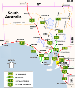
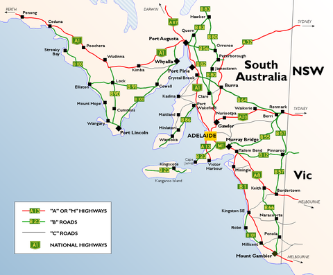
is distinctly divided into two main areas; the well watered and populated southeastern corner and the arid outback for the rest of the state. As a result, highways are concentrated mainly in the southeast. The Eyre Highway to Perth and Stuart Highway to Darwin are the only significant highways for the remaining part of the state. The remaining roads are outback tracks. This is the list of highways in South Australia
South Australia
South Australia is a state of Australia in the southern central part of the country. It covers some of the most arid parts of the continent; with a total land area of , it is the fourth largest of Australia's six states and two territories.South Australia shares borders with all of the mainland...
.
Expressways
Adelaide
Adelaide is the capital city of South Australia and the fifth-largest city in Australia. Adelaide has an estimated population of more than 1.2 million...
:
- Southern Expressway
 Southern ExpresswayThe Southern Expressway is the world's longest reversible one way freeway. Originally proposed as 'Noarlunga Freeway', it was built as a corridor to relieve heavy traffic from the major arterial, Main South Road, in Adelaide's south. The expressway was built in two stages — the first...
21 km (13 mi) (the world's longest reversible one way freewayReversible laneA reversible lane , called a counterflow lane or contraflow lane in transport engineering nomenclature, is a lane in which traffic may travel in either direction, depending on certain conditions...
), completed in 1997 - Port River Expressway
 Port River ExpresswayThe Port River Expressway is a freeway-grade road. The expressway links Port Adelaide and the LeFevre Peninsula to the northern suburbs of Adelaide and major interstate routes via Salisbury Highway to Port Wakefield Road and the Northern Expressway to Perth and Sydney.The expressway is only...
5.5 km (3.4 mi), completed in 2008 - Northern ExpresswayNorthern ExpresswayThe Northern Expressway is a 23 kilometre long controlled-access highway in Adelaide, South Australia. It travels from Gawler to Port Wakefield Road...
23 km (14.3 mi), completed in 2010
A fourth, the Northern Connector
Northern Connector
The Northern Connector is a 15 kilometre long proposed expressway in Adelaide, South Australia. It will travel from the proposed South Road Superway at Wingfield to the new Northern Expressway as part of an ongoing plan to develop a continuous freeway grade road between Victor Harbor and Nuriootpa...
is planned, however this will simply be an extension of the Northern Expressway.
Metropolitan
 Adelaide-Crafers HighwayAdelaide-Crafers HighwayThe Adelaide-Crafers Highway is a 10 kilometre controlled-access highway linking Adelaide city centre to Crafers in the Adelaide hills, and continuing from Crafers as the South Eastern Freeway. The highway is ten kilometres long, including 500 metre long twin-tube tunnels , the first of their kind...
 Port Wakefield RoadPort Wakefield RoadPort Wakefield Road is an important Australian highway. It connects Adelaide, the South Australian capital, to the Yorke Peninsula, Port Augusta, northern and western South Australia, the Northern Territory and Western Australia. It is designated National Highway A1 and a part of the National Highway...
- Salisbury HighwaySalisbury HighwayThe Salisbury Highway, , is a 12 kilometre major connecting road in the northern suburbs of the Adelaide metropolitan area....
- South Road
- Salisbury Highway
 Grand Junction Road
- Ascot Avenue
- Hampstead Road
- Portrush Road
- Northern ExpresswayNorthern ExpresswayThe Northern Expressway is a 23 kilometre long controlled-access highway in Adelaide, South Australia. It travels from Gawler to Port Wakefield Road...
Rural
- South Eastern FreewaySouth Eastern FreewayThe South Eastern Freeway is a 66 kilometre four-lane divided carriageway road in South Australia linking the Adelaide-Crafers Highway to the Princes Highway at the Swanport Bridge, a one kilometre long bridge over the River Murray, near Murray Bridge...
- Majority -
- Eyre HighwayEyre HighwayThe Eyre Highway is a highway linking Western Australia and South Australia via the Nullarbor Plain. Signed as National Highway 1/A1, it forms part of Highway 1 and the Australian National Highway network linking Perth and Adelaide. It was named after explorer Edward John Eyre, who was the first to...
- Princes HighwayPrinces HighwayThe Princes Highway extends from Sydney to Port Augusta via the coast through the states of New South Wales, Victoria and South Australia, a distance of 1941 km or 1898 km via the former alignments of the highway ....
- Eyre Highway
 Dukes HighwayDukes HighwayThe Dukes Highway is an important 189 kilometre highway corridor in South Australia which links the Australian cities of Adelaide and Melbourne. It is part of the National Highway system spanning Australia, and is signed as National Highway A8....
 Sturt HighwaySturt HighwayThe Sturt Highway is an Australian highway in New South Wales, Victoria, and South Australia. It is part of the Auslink National network and is part of the main highway route between Sydney and Adelaide.-Route:...
 Stuart HighwayStuart HighwayThe Stuart Highway is one of Australia's major highways. It is a segment of Australia's Highway 1 extending from Darwin, Northern Territory, in the north, via Tennant Creek and Alice Springs, to Port Augusta, South Australia, in the south—a distance of...
Metropolitan
- Southern ExpresswaySouthern ExpresswayThe Southern Expressway is the world's longest reversible one way freeway. Originally proposed as 'Noarlunga Freeway', it was built as a corridor to relieve heavy traffic from the major arterial, Main South Road, in Adelaide's south. The expressway was built in two stages — the first...
 Anzac Highway
- Port River ExpresswayPort River ExpresswayThe Port River Expressway is a freeway-grade road. The expressway links Port Adelaide and the LeFevre Peninsula to the northern suburbs of Adelaide and major interstate routes via Salisbury Highway to Port Wakefield Road and the Northern Expressway to Perth and Sydney.The expressway is only...
 Salisbury HighwaySalisbury HighwayThe Salisbury Highway, , is a 12 kilometre major connecting road in the northern suburbs of the Adelaide metropolitan area....
 Lower North East Rd
 Port Rd
Rural
 Princes HighwayPrinces HighwayThe Princes Highway extends from Sydney to Port Augusta via the coast through the states of New South Wales, Victoria and South Australia, a distance of 1941 km or 1898 km via the former alignments of the highway ....
 Princes HighwayPrinces HighwayThe Princes Highway extends from Sydney to Port Augusta via the coast through the states of New South Wales, Victoria and South Australia, a distance of 1941 km or 1898 km via the former alignments of the highway ....
 Mallee HighwayMallee HighwayThe Mallee Highway runs east from Tailem Bend in South Australia through cereal-growing farmland at the southern end of the Murray Mallee to Pinnaroo near the border with Victoria, where it crosses route...
 Barossa Valley HighwayBarossa Valley HighwayThe Barossa Valley Highway is the main road linking most of the major towns of the Barossa Valley in South Australia. It is designated as highway B19...
- Barrier HighwayBarrier HighwayThe Barrier Highway is a highway in New South Wales and South Australia signposted as in South Australia and in New South Wales, Australia.The Barrier Highway starts at Nyngan where it joins the Mitchell Highway. It heads west past Hermidale and Boppy Mountain to Cobar, a mining town. It then...
- Main North RoadMain North RoadMain North Road is the major north-south arterial route north of the city of Adelaide, South Australia.From the Adelaide city centre, it passes through the Adelaide Parklands and the suburbs of Thorngate, Medindie, Medindie Gardens, Nailsworth, Prospect, Sefton Park, Blair Athol and Enfield before...
- Barrier Highway
 Riddoch HighwayRiddoch HighwayThe Riddoch Highway in south-eastern South Australia branches from the Dukes Highway at Keith and travels south through Padthaway, Naracoorte, Penola, Nangwarry, Tarpeena, and Mount Gambier to Port MacDonnell and nearby Cape Northumberland....
 Tod HighwayTod HighwayTod Highway is an important 177 kilometre highway serving South Australia's Eyre Peninsula's wheatbelt. It runs from Kyancutta, on the Eyre Highway to Port Lincoln and signed as B90. It practically divides the Eyre Peninsula into eastern and western halves. It is named after Robert Tod who explored...
- Flinders HighwayFlinders Highway, South AustraliaFlinders Highway connects the South Australian towns of Ceduna and Port Lincoln, a distance of 410 kilometres. The highway was formerly designated as National Route Alternate 1 and currently signed as B100...
- Lincoln HighwayLincoln Highway (Australia)Lincoln Highway links Port Augusta and Port Lincoln, both located in South Australia, a distance of 327 kilometres. It was formerly designated as National Route Alternate 1 and is currently B100....
- Flinders Highway
 Southern Ports HighwaySouthern Ports HighwayThe Southern Ports Highway is a 117 kilometre highway in South Australia that connects Kingston SE with Millicent via Rendelsham, Southend, Beachport and Robe. It is of good standard and is about 100 km long and was fully sealed in 1978. It was originally part of Highway 1, but is now...
Major Arterial Roads
-
- Glen Osmond Road
- Main North RoadMain North RoadMain North Road is the major north-south arterial route north of the city of Adelaide, South Australia.From the Adelaide city centre, it passes through the Adelaide Parklands and the suburbs of Thorngate, Medindie, Medindie Gardens, Nailsworth, Prospect, Sefton Park, Blair Athol and Enfield before...
 Cross RoadCross Road, AdelaideCross Road is a major arterial road that travels east-west through the inner southern suburbs of the Australian city of Adelaide. Its western terminus is at Anzac Highway, travelling east and ending at Glen Osmond and the Adelaide Hills, joining the junction of Glen Osmond Road, Portrush Road, and...
- Sir Donald Bradman Drive
- Burbridge Road
- Port RoadPort RoadPort Road may refer to:*Port Road, Adelaide, South Australia*Container Port Road, Hong Kong*Icknield Port Road railway station, Birmingham, England*Port Road, Barry, Barry, Vale of Glamorgan, Wales...

- Adelaide-Mannum RoadAdelaide-Mannum RoadAdelaide–Mannum Road is a road that runs through the northern Adelaide Hills between the South Australian capital, Adelaide and Mannum on the Murray River. It is designated State Highway A10 in the metropolitan area and B10 in rural areas, and is 77 kilometres in length. It is named after the two...
- North East Road
- Adelaide-Mannum Road
-
- South RoadSouth Road, AdelaideSouth Road is a major north–south conduit in Adelaide, South Australia. Also known as Main South Road, it is Adelaide's most important arterial road.- Route :...
- Victor Harbor RoadVictor Harbor RoadThe Victor Harbor Road is on the Fleurieu Peninsula, South Australia. It runs from Main South Road at Old Noarlunga south to Victor Harbor, bypassing the towns of McLaren Vale and Willunga, and passing through Mount Compass.-Route:...
- South Road
 Tapleys Hill Road
- Grand Junction RoadGrand Junction Road, AdelaideGrand Junction Road is the longest east-west thoroughfare in the Adelaide metropolitan area, and is located approximately 9 kilometres north of the city centre. Travelling from the Port Adelaide region, it is mostly a double lane sealed road running 21 kilometres to the base of the Adelaide Hills...
- Victoria RoadVictoria Road, AdelaideVictoria Road is major road in Adelaide, South Australia, connecting Port Adelaide to the LeFevre Peninsula and Outer Harbor....
- Grand Junction Road

- Mcintyre Road
- Kings Road
-
- Main North RoadMain North RoadMain North Road is the major north-south arterial route north of the city of Adelaide, South Australia.From the Adelaide city centre, it passes through the Adelaide Parklands and the suburbs of Thorngate, Medindie, Medindie Gardens, Nailsworth, Prospect, Sefton Park, Blair Athol and Enfield before...
- Gawler Bypass RoadGawler bypass roadGawler Bypass Road is a major north-south route in the outer northern suburbs of the city of Adelaide, South Australia. It has the National designation of north of the Northern Expressway, while south of this intersection it has the State designation of ....
- Main North Road
 South RoadSouth Road, AdelaideSouth Road is a major north–south conduit in Adelaide, South Australia. Also known as Main South Road, it is Adelaide's most important arterial road.- Route :...
- Macclesfield RoadMacclesfield Road, South AustraliaMacclesfield Road / Aldgate-Strathalbyn Road is a South Australian road connecting the towns of Echunga, Macclesfield and Strathalbyn.The road is a secondary route, hence has been given the State Route designation of B33. Its links the B34 with B37 ....
- Aldgate-Strathalbyn RoadMacclesfield Road, South AustraliaMacclesfield Road / Aldgate-Strathalbyn Road is a South Australian road connecting the towns of Echunga, Macclesfield and Strathalbyn.The road is a secondary route, hence has been given the State Route designation of B33. Its links the B34 with B37 ....
- Macclesfield Road

- Onkaparinga Valley RoadOnkaparinga Valley Road, South AustraliaOnkaparinga Valley Road is a South Australian secondary road, connecting the towns of Birdwood, Woodside, Balhannah and Hahndorf with Meadows and Willunga on the Fleurieu Peninsula...
- Echunga Road
- Battunga Road
- Brookmans Road
- Meadows Road
- Onkaparinga Valley Road
 Wellington Road
- Main North RoadMain North RoadMain North Road is the major north-south arterial route north of the city of Adelaide, South Australia.From the Adelaide city centre, it passes through the Adelaide Parklands and the suburbs of Thorngate, Medindie, Medindie Gardens, Nailsworth, Prospect, Sefton Park, Blair Athol and Enfield before...
- Wilmington-Ucolta RoadWilmington-Ucolta RoadWilmington–Ucolta Road is a 98 kilometre major road connecting Port Augusta to Peterborough and beyond to Broken Hill, in South Australia. It forms as a connecter road between the Princes Highway and the Barrier Highway through the Flinders Ranges, and forms the most direct path between Port...
- Main North Road
 Wilmington-Ucolta RoadWilmington-Ucolta RoadWilmington–Ucolta Road is a 98 kilometre major road connecting Port Augusta to Peterborough and beyond to Broken Hill, in South Australia. It forms as a connecter road between the Princes Highway and the Barrier Highway through the Flinders Ranges, and forms the most direct path between Port...
 Main North RoadMain North RoadMain North Road is the major north-south arterial route north of the city of Adelaide, South Australia.From the Adelaide city centre, it passes through the Adelaide Parklands and the suburbs of Thorngate, Medindie, Medindie Gardens, Nailsworth, Prospect, Sefton Park, Blair Athol and Enfield before...
Outback Tracks
Although not highways as such, unsealed outback tracks form important links to remote communities and areas, the significant ones include;- Anne Beadell HighwayAnne Beadell HighwayThe Anne Beadell Highway is an outback unsealed track linking Coober Pedy, South Australia, and Laverton, Western Australia. The track was surveyed and built by Len Beadell, Australian surveyor, who named it after his wife. -Overview:...
 Birdsville TrackBirdsville TrackThe Birdsville Track is a notable outback road in Australia. The 517 km track runs from Marree, a small town in northern South Australia, north across the Tirari Desert and Sturt Stony Desert, ending in Birdsville in south western Queensland....
- Gunbarrel HighwayGunbarrel HighwayThe Gunbarrel Highway is an isolated desert track in the Northern Territory, South Australia and Western Australia. It consists of about of washaways, heavy corrugations, stone, sand and flood plains...
 Oodnadatta TrackOodnadatta TrackThe Oodnadatta Track , Australia is an unsealed 620 kilometre track between Marree and Marla via Oodnadatta in South Australia. It passes the southern lake of the Lake Eyre National Park....
 Strzelecki TrackStrzelecki TrackThe Strzelecki Track is an outback track in South Australia, mostly unsealed but with a few short sealed sections to facilitate overtaking, linking Innamincka to Lyndhurst...