
List of crossings of the Charles River
Encyclopedia
- "Charles River Bridge" redirects here; see below for the historic structures or Charles River Bridge v. Warren BridgeCharles River Bridge v. Warren BridgeCharles River Bridge v. Warren Bridge, 36 U.S. 420 , was a case regarding the Charles River Bridge and the Warren Bridge of Boston, Massachusetts, heard by the United States Supreme Court under the leadership of Chief Justice Roger B. Taney...
for the lawsuit.
Charles River
The Charles River is an long river that flows in an overall northeasterly direction in eastern Massachusetts, USA. From its source in Hopkinton, the river travels through 22 cities and towns until reaching the Atlantic Ocean at Boston...
from its mouth at Boston Harbor
Boston Harbor
Boston Harbor is a natural harbor and estuary of Massachusetts Bay, and is located adjacent to the city of Boston, Massachusetts. It is home to the Port of Boston, a major shipping facility in the northeast.-History:...
upstream to its source at Echo Lake. All locations are in Massachusetts
Massachusetts
The Commonwealth of Massachusetts is a state in the New England region of the northeastern United States of America. It is bordered by Rhode Island and Connecticut to the south, New York to the west, and Vermont and New Hampshire to the north; at its east lies the Atlantic Ocean. As of the 2010...
.
| Crossing | Carries | Location | Built | Notes | Coordinates |
|---|---|---|---|---|---|
| ferry (historical) | Boston to Charlestown Charlestown, Massachusetts Charlestown is a neighborhood of Boston, Massachusetts, United States, and is located on a peninsula north of downtown Boston. Charlestown was originally a separate town and the first capital of the Massachusetts Bay Colony; it became a city in 1847 and was annexed by Boston on January 5, 1874... |
1630 | Operated by various private individuals under colonial sanction, then Harvard College in 1640. Obsoleted by Charles River Bridge Charlestown Bridge The Charlestown Bridge is the easternmost bridge on the Charles River in Boston, Massachusetts. The bridge formerly carried the southernmost stretch of Massachusetts Route 99, which now ends at Chelsea Street in Charlestown. It connects to Joe Tecce Way to the south and to Rutherford Avenue to the... , at the same location. |
||
| Charlestown Bridge Charlestown Bridge The Charlestown Bridge is the easternmost bridge on the Charles River in Boston, Massachusetts. The bridge formerly carried the southernmost stretch of Massachusetts Route 99, which now ends at Chelsea Street in Charlestown. It connects to Joe Tecce Way to the south and to Rutherford Avenue to the... (Charles River Bridge) |
 Rt. 99 Rt. 99 |
1786 (Charles River Bridge), 1900 | 42°22′08"N 71°03′36"W | ||
| Charles River Dam Charles River Dam The Charles River Dam is a flood control structure on the Charles River in Boston, Massachusetts, located just downstream of the Leonard P. Zakim Bunker Hill Memorial Bridge, near Lovejoy Wharf, on the former location of the Warren Bridge.-History:... |
pedestrians and bicycles | 1978 | Fish ladder, pumps and three locks for navigation. Constructed on the site of the Warren Bridge. | 42°22′07"N 71°03′41.10"W | |
| Warren Bridge Warren Bridge The Warren Bridge connected downtown Boston, Massachusetts with Charlestown from its construction in the 1820s until its demolition in 1962. It was replaced by the Charles River Dam in 1978.... |
1828 | Demolished in 1962. | |||
| Charlestown High Bridge Charlestown High Bridge The Charlestown High Bridge , spanned the Charles River in Boston, Massachusetts, and was part of Interstate 93 and U.S... |
 I-93 I-93Interstate 93 Interstate 93 is an Interstate Highway in the New England section of the United States. Its southern terminus is in Canton, Massachusetts, in the Boston metropolitan area, at Interstate 95; its northern terminus is near St. Johnsbury, Vermont, at Interstate 91...  US 1 US 1U.S. Route 1 U.S. Route 1 is a major north–south U.S. Highway that serves the East Coast of the United States. It runs 2,377 miles from Fort Kent, Maine at the Canadian border south to Key West, Florida. U.S. 1 generally parallels Interstate 95, though it is significantly farther west between... |
1956 | Demolished in 2004. | ||
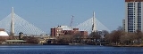
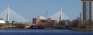
| Leonard P. Zakim Bunker Hill Bridge | I-93 Interstate 93 Interstate 93 is an Interstate Highway in the New England section of the United States. Its southern terminus is in Canton, Massachusetts, in the Boston metropolitan area, at Interstate 95; its northern terminus is near St. Johnsbury, Vermont, at Interstate 91... US 1U.S. Route 1 U.S. Route 1 is a major north–south U.S. Highway that serves the East Coast of the United States. It runs 2,377 miles from Fort Kent, Maine at the Canadian border south to Key West, Florida. U.S. 1 generally parallels Interstate 95, though it is significantly farther west between... |
2003 | 42°22′08"N 71°03′49"W | ||
| MBTA Orange Line Orange Line (MBTA) The Orange Line is one of the four subway lines of the Massachusetts Bay Transportation Authority. It extends from Forest Hills in Jamaica Plain, Boston in the south to Oak Grove in Malden, Massachusetts in the north. It meets the Red Line at Downtown Crossing, the Blue Line at State, and the Green... Haymarket North Extension Haymarket North Extension The Haymarket North Extension is an underground crossing of the Charles River which carries the Massachusetts Bay Transportation Authority's Orange Line; the term is also applied to the rerouting of the Orange Line in 1975. The rerouting moved the north end of the Orange line into a new tunnel... (tunnel) |
MBTA Orange Line Orange Line (MBTA) The Orange Line is one of the four subway lines of the Massachusetts Bay Transportation Authority. It extends from Forest Hills in Jamaica Plain, Boston in the south to Oak Grove in Malden, Massachusetts in the north. It meets the Red Line at Downtown Crossing, the Blue Line at State, and the Green... |
1975 | |||
| Leverett Circle Connector Bridge Leverett Circle Connector Bridge The Leverett Circle Connector Bridge is a highway bridge over the Charles River, carrying two lanes each of northbound and southbound traffic. It connects to Interstate 93 in Somerville, Massachusetts at the north end and splits at the south end, providing direct access to both Storrow Drive and... |
Boston to Cambridge Cambridge, Massachusetts Cambridge is a city in Middlesex County, Massachusetts, United States, in the Greater Boston area. It was named in honor of the University of Cambridge in England, an important center of the Puritan theology embraced by the town's founders. Cambridge is home to two of the world's most prominent... |
1999 | 42°22′08"N 71°03′52"W | ||
| MBTA Commuter Rail MBTA Commuter Rail The MBTA Commuter Rail serves as the regional rail arm of the Massachusetts Bay Transportation Authority, in the United States. It is operated under contract by the Massachusetts Bay Commuter Railroad Company a joint partnership of Veolia Transportation, Bombardier Transportation and Alternate... Charles River Bridge Charles River Bridge (Commuter Rail) The Charles River Bridge is a pair of railroad single-leaf, through-truss, rolling bascule bridges across the Charles River that connects North Station in Boston, Massachusetts to MBTA Commuter Rail lines in northern Massachusetts.- Design and construction :... (aka "bascule bridge") |
MBTA Commuter Rail MBTA Commuter Rail The MBTA Commuter Rail serves as the regional rail arm of the Massachusetts Bay Transportation Authority, in the United States. It is operated under contract by the Massachusetts Bay Commuter Railroad Company a joint partnership of Veolia Transportation, Bombardier Transportation and Alternate... at North Station |
1931 | 42°22′8.29"N 71°03′54.96"W | ||
| Boston and Lowell Railroad Boston and Lowell Railroad The Boston and Lowell Railroad is a historic railroad that operated in Massachusetts. It was one of the first railroads in North America and the first major one in the state... Charles River Bridge (removed) |
1835 | first movable railroad bridge in the United States http://memory.loc.gov/pnp/habshaer/ma/ma1100/ma1194/data/003.tif | |||
| MBTA Green Line Green Line (MBTA) The Green Line is a streetcar system run by the Massachusetts Bay Transportation Authority in the Boston, Massachusetts area of the United States. It is the oldest line of Boston's subway, which is known locally as the 'T'. The Green Line runs underground downtown and on the surface in outlying... Lechmere Viaduct Lechmere Viaduct The Lechmere Viaduct is the last remaining elevated portion of the MBTA's Green Line in Boston, Massachusetts. Opened June 1, 1912, the Viaduct connects the Lechmere stop to the Science Park Station at Leverett Circle. Currently, the Green Line descends into a tunnel just east of Science Park... |
MBTA Green Line Green Line (MBTA) The Green Line is a streetcar system run by the Massachusetts Bay Transportation Authority in the Boston, Massachusetts area of the United States. It is the oldest line of Boston's subway, which is known locally as the 'T'. The Green Line runs underground downtown and on the surface in outlying... |
1912 | 42°22′2.32"N 71°04′8.29"W | ||
| Charles River Dam Bridge Charles River Dam Bridge The Charles River Dam Bridge, officially the Craigie Bridge, also called Craigie's Bridge or the Canal Bridge, is a six-lane bascule bridge across the Charles River, connecting Leverett Circle in downtown Boston, to Monsignor O'Brien Highway in East Cambridge, Massachusetts... |
 Rt. 28 Rt. 28Route 28 (Massachusetts) Route 28 is a nominally south–north route in the U.S. state of Massachusetts, running from the town of Orleans via Boston to the New Hampshire state line in Methuen. Following the route from its nominally southern end, Route 28 initially heads south to the town of Chatham then turns west to... |
1910 | 42°22′01.66"N 71°04′08.87"W | ||
| Longfellow Bridge Longfellow Bridge The Longfellow Bridge, also known to locals as the "Salt-and-Pepper Bridge" or the "Salt-and-Pepper-Shaker Bridge" due to the shape of its central towers, carries Route 3 and the Massachusetts Bay Transportation Authority's Red Line across the Charles River to connect Boston's Beacon Hill... |
 Rt. 3 Rt. 3Route 3 (Massachusetts) Route 3 is a southward continuation of U.S. Route 3, connecting Cambridge, Massachusetts with Cape Cod. All of it, except for the northernmost end in downtown Boston and Cambridge, is a freeway.... MBTA Red Line Red Line (MBTA) The Red Line is a rapid transit line operated by the MBTA running roughly north-south through Boston, Massachusetts into neighboring communities. The line begins west of Boston, in Cambridge, Massachusetts at Alewife station, near the intersection of Alewife Brook Parkway and Route 2... |
1793 (West Boston Bridge), 1907 | MBTA Red Line Red Line (MBTA) The Red Line is a rapid transit line operated by the MBTA running roughly north-south through Boston, Massachusetts into neighboring communities. The line begins west of Boston, in Cambridge, Massachusetts at Alewife station, near the intersection of Alewife Brook Parkway and Route 2... in median; built in 1907 as the Cambridge Bridge, renamed for Henry Wadsworth Longfellow Henry Wadsworth Longfellow Henry Wadsworth Longfellow was an American poet and educator whose works include "Paul Revere's Ride", The Song of Hiawatha, and Evangeline... in 1927. |
42°21′41"N 71°04′32"W | |
| Harvard Bridge Harvard Bridge The Harvard Bridge carries Massachusetts Avenue from Back Bay, Boston to Cambridge, Massachusetts. It is the longest bridge over the Charles River.... |
 Rt. 2A Rt. 2ARoute 2A (Massachusetts) Route 2A exists in several sections of Massachusetts, mainly as parts of former Route 2 that have been moved or upgraded. Route 2A runs from Greenfield in the west to Boston in the east... (Massachusetts Avenue Massachusetts Avenue (Boston) Massachusetts Avenue, known to locals as Mass Ave, is a major thoroughfare in Boston, Massachusetts, and several cities and towns northwest of Boston... |
1891, 1909 (rebuilt), 1924 (overhaul), 1990 (rebuilt) | Longest bridge over the Charles. Northern terminus at MIT, not Harvard University Harvard University Harvard University is a private Ivy League university located in Cambridge, Massachusetts, United States, established in 1636 by the Massachusetts legislature. Harvard is the oldest institution of higher learning in the United States and the first corporation chartered in the country... . |
42°21′15"N 71°05′28"W | |
| Boston University Bridge Boston University Bridge The Boston University Bridge , and commonly referred to as the BU Bridge, is a steel truss bridge with a suspended deck carrying Route 2 over the Charles River, connecting Boston to Cambridge, Massachusetts. According to the American Association of State Highway and Transportation Officials route... (built as the Cottage Farm Bridge) |
 Rt. 2 Rt. 2Route 2 (Massachusetts) Route 2 is a major east–west state highway in Massachusetts, parts of which are sometimes known as the Cambridge and Concord Turnpike. Along with Route 9 and U.S. Route 20 to the south, these highways are the main alternatives to the Massachusetts Turnpike/I-90 toll highway... |
1928 | renamed in 1949 | 42°21′09.12"N 71°06′38.26"W | |
| Grand Junction Railroad Grand Junction Railroad The Grand Junction Railroad is an 8.55-mile long railroad in the Boston, Massachusetts area, connecting the railroads heading west and north from Boston... bridge |
MBTA Grand Junction Branch | crosses the river under the Boston University Bridge Boston University Bridge The Boston University Bridge , and commonly referred to as the BU Bridge, is a steel truss bridge with a suspended deck carrying Route 2 over the Charles River, connecting Boston to Cambridge, Massachusetts. According to the American Association of State Highway and Transportation Officials route... |
42°21′09.69"N 71°06′36.72"W | ||
| River Street Bridge River Street Bridge The River Street Bridge is a bridge connecting River Street in Cambridge, MA to Cambridge Street in Allston, Boston, MA. It was built in 1925 by the Commonwealth of Massachusetts Metropolitan District Commission.... |
1926 | 42°21′41"N 71°07′00"W | |||
| Western Avenue Bridge Western Avenue Bridge The Western Avenue Bridge is a bridge carrying Western Avenue over the Charles River between Cambridge, MA and Allston, Boston, MA. It was built in 1924 by the Commonwealth of Massachusetts Metropolitan District Commission.... |
1924 | 42°21′51.25"N 71°07′01.13"W | |||
| John W. Weeks Bridge John W. Weeks Bridge The John W. Weeks Bridge, usually called the Weeks Footbridge , is a pedestrian bridge over the Charles River connecting Cambridge, Massachusetts with the Allston section of Boston.John W. Weeks was a longtime U.S... |
pedestrians | 1926 | the only pedestrian bridge across the basin, with a Harvard campus Harvard University Harvard University is a private Ivy League university located in Cambridge, Massachusetts, United States, established in 1636 by the Massachusetts legislature. Harvard is the oldest institution of higher learning in the United States and the first corporation chartered in the country... steam tunnel inside |
42°22′6.63"N 71°07′05.26"W | |
| ferry (historical) | at the foot of Dunster Street in Cambridge, at canal/creek; | 1635 | Obsoleted by Great Bridge | ||
| Anderson Memorial Bridge Anderson Memorial Bridge Anderson Memorial Bridge connects Allston, a neighborhood of Boston, and Cambridge. The bridge stands on the site of the Great Bridge built in 1662, the first structure to span the Charles River... (Great Bridge Great Bridge (Cambridge) The Great Bridge over the Charles River connected Cambridge, Massachusetts, to what is now known as Allston, Boston, Massachusetts. The Great Bridge was built in 1660-1662 at what was then called Brighton Street, and was the first bridge to span the Charles. A toll was authorized in 1670... ) |
N. Harvard Street/JFK Street | 1662 (Great Bridge Great Bridge (Cambridge) The Great Bridge over the Charles River connected Cambridge, Massachusetts, to what is now known as Allston, Boston, Massachusetts. The Great Bridge was built in 1660-1662 at what was then called Brighton Street, and was the first bridge to span the Charles. A toll was authorized in 1670... ), 1862 (rebuilt), 1912 (Anderson Memorial Bridge Anderson Memorial Bridge Anderson Memorial Bridge connects Allston, a neighborhood of Boston, and Cambridge. The bridge stands on the site of the Great Bridge built in 1662, the first structure to span the Charles River... ) |
a memorial to Nicholas Longworth Anderson Nicholas Longworth Anderson Nicholas Longworth Anderson was a United States Army officer who served in the American Civil War as Colonel of the 6th Ohio Volunteer Infantry.-Biography:... donated by his son Larz Anderson Larz Anderson Larz Anderson III was a wealthy American businessman and diplomat who briefly served as U.S. Ambassador to Japan .... |
42°22′08"N 71°07′23"W | |
| Eliot Bridge Eliot Bridge The Eliot Bridge is a bridge over the Charles River between Cambridge, Massachusetts and Allston, Boston, Massachusetts. It connects Soldiers Field Road in Allston with Gerry's Landing Road, Memorial Drive, Greenough Boulevard, and the Fresh Pond Parkway in Cambridge.The bridge was built in 1950... |
1950 | a memorial to Charles W. Eliot Charles William Eliot Charles William Eliot was an American academic who was selected as Harvard's president in 1869. He transformed the provincial college into the preeminent American research university... , Harvard president President of Harvard University The President of Harvard University is the chief administrator of the university. Ex officio the chairman of the Harvard Corporation, he or she is appointed by and is responsible to the other members of that body, who delegate to him or her the day-to-day running of the university... 1869–1909, and his son Charles Eliot, landscape architect Landscape architect A landscape architect is a person involved in the planning, design and sometimes direction of a landscape, garden, or distinct space. The professional practice is known as landscape architecture.... for the Metropolitan Park Commission |
42°22′18"N 71°07′59"W | ||
| Arsenal Street Bridge Arsenal Street Bridge The Arsenal Street Bridge is a bridge connecting Arsenal Street in Watertown, Massachusetts to Western Avenue in Allston, Boston, Massachusetts. It was built in 1925 by the Commonwealth of Massachusetts Metropolitan District Commission.... |
Brighton to Watertown Watertown, Massachusetts The Town of Watertown is a city in Middlesex County, Massachusetts, United States. The population was 31,915 at the 2010 census.- History :Archeological evidence suggests that Watertown was inhabited for thousands of years before the arrival of settlers from England... |
1925 | 42°21′42"N 71°08′50"W | ||
| North Beacon Street Bridge North Beacon Street Bridge The North Beacon Street Bridge is a bridge carrying North Beacon Street over the Charles River between Watertown, MA and Brighton, Boston, MA... |
 US 20 US 20U.S. Route 20 U.S. Route 20 is an east–west United States highway. As the "0" in its route number implies, US 20 is a coast-to-coast route. Spanning , it is the longest road in the United States, and the route sparsely parallels Interstate 90... |
1917 | 42°21′32"N 71°09′42"W | ||
| Watertown Bridge Watertown Bridge The Watertown Bridge is a five-lane traffic bridge over the Charles River, carrying Rt. 16 and Galen Street. It connects Watertown Square on the north side and Watertown Yard on the south side of Watertown, Massachusetts. Pedestrian walkways line each side.... |
 Rt. 16 Galen Street Rt. 16 Galen Street |
Watertown Watertown, Massachusetts The Town of Watertown is a city in Middlesex County, Massachusetts, United States. The population was 31,915 at the 2010 census.- History :Archeological evidence suggests that Watertown was inhabited for thousands of years before the arrival of settlers from England... |
about 1907 | 42°21′53"N 71°11′08"W | |
| Watertown Dam Watertown Dam The Watertown Dam spans the Charles River upstream from the Watertown Bridge near Watertown Square in the Town of Watertown, Massachusetts where the Charles River tidal estuary ends. Watertown Dam is of earthen construction, a gravity dam. Its length is . Its capacity is . Normal storage is... |
about 1634 | 42°21′55.27"N 71°11′21.34"W | |||
| Cpl. Joseph U. Thompson Footbridge | 42°21′54.39"N 71°11′24.97"W | ||||
| Bridge Street | Newton Newton, Massachusetts Newton is a city in Middlesex County, Massachusetts, United States bordered to the east by Boston. According to the 2010 U.S. Census, the population of Newton was 85,146, making it the eleventh largest city in the state.-Villages:... to Watertown Watertown, Massachusetts The Town of Watertown is a city in Middlesex County, Massachusetts, United States. The population was 31,915 at the 2010 census.- History :Archeological evidence suggests that Watertown was inhabited for thousands of years before the arrival of settlers from England... |
42°21′56.87"N 71°12′15.96"W | |||
| Bemis Dam (breached) | 1821 | breached 1944 | 42°21′56.58"N 71°12′17.92"W | ||
| Blue Heron Footbridge | pedestrians and bicycles | 2005 | 42°21′53.33"N 71°12′45.85"W | ||
| Farwell Street | Waltham Waltham, Massachusetts Waltham is a city in Middlesex County, Massachusetts, United States, was an early center for the labor movement, and major contributor to the American Industrial Revolution. The original home of the Boston Manufacturing Company, the city was a prototype for 19th century industrial city planning,... |
42°22′51.47"N 71°13′5.12"W | |||
| Bleachery Dam (originally Gore Paper Mill dam) | 1794 | 42°22′8.83"N 71°13′22.74"W | |||
| Mary T. Early Footbridge (formerly Calvary Street Footbridge) | 42°22′10.74"N 71°13′25.94"W | ||||
| Boston & Maine Railroad trestle (abandoned) | abandoned Watertown Branch | 42°22′11.11"N 71°13′26.29"W | |||
| Charles F. Graceffa Bridge (Newton Street) | (original built 1761) | 42°22′21.10"N 71°13′43.51"W | |||
| Elm Street Bridge | 42°22′22.87"N 71°13′57.19"W | ||||
| Boston & Maine Railroad trestle (abandoned) | abandoned Watertown Branch | 42°22′22.21"N 71°13′59.12"W | |||
| Richard Landry Park footbridge | 1978 | 42°22′20.59"N 71°14′5.95"W | |||
| Waltham Dam or Moody Street Dam (original Eden Vale dam built 1785) | 1836 | 42°22′22.87"N 71°14′10.24"W | |||
| Moody Street bridge | (original built 1846, rebuilt 1871, 1921) 1946 | 42°22′23.61"N 71°14′11.63"W | |||
| Gold Star Mothers Bridge, Prospect Street | (drawbridge 1882) 1889 | 42°22′7.91"N 71°14′36.93"W | |||
| Weston Aqueduct | |||||
| Commonwealth Avenue Commonwealth Avenue Commonwealth Avenue is an avenue which may refer to:in Australia*Commonwealth Avenue, Canberrain the Philippines*Commonwealth Avenue, Quezon Cityin Singapore*Commonwealth Avenue, Singaporein the United States... , Newton / South Avenue, Weston |
 Rt. 30 Rt. 30Route 30 (Massachusetts) Route 30 is an east–west arterial, connecting Grafton with Packard's Corner in Boston. Route 30 runs roughly parallel to the Massachusetts Turnpike and Route 9, but unlike those two larger highways, takes a more meandering path from town to town... |
Newton Newton, Massachusetts Newton is a city in Middlesex County, Massachusetts, United States bordered to the east by Boston. According to the 2010 U.S. Census, the population of Newton was 85,146, making it the eleventh largest city in the state.-Villages:... to Weston Weston, Massachusetts Weston is a suburb of Boston located in Middlesex County, Massachusetts, United States in the Boston metro area. The population of Weston, according to the 2010 U.S. Census, is 11,261.... |
site of old Norumbega Bridge | 42°20′38.27"N 71°15′41.01"W | |
| MetroWest Tunnel (aqueduct) | |||||
| I-90/I-95 connector |  I-90 I-90Interstate 90 Interstate 90 is the longest Interstate Highway in the United States at . It is the northernmost coast-to-coast interstate, and parallels US 20 for the most part. Its western terminus is in Seattle, at Edgar Martinez Drive S. near Safeco Field and CenturyLink Field, and its eastern terminus is in...  I-95 I-95Interstate 95 in Massachusetts Interstate 95 is the main highway on the East Coast of the United States, paralleling the Atlantic Ocean from Florida to Maine. The Massachusetts portion of the highway enters from the state of Rhode Island in Attleboro and travels in a northeasterly direction to the junction with Route 128 in... |
original Mass Pike terminus until 1964 | 42°20′29.76"N 71°15′42.51"W | ||
| Hultman Aqueduct | |||||
| Massachusetts Turnpike Massachusetts Turnpike The Massachusetts Turnpike is the easternmost stretch of Interstate 90. The Turnpike begins at the western border of Massachusetts in West Stockbridge connecting with the Berkshire Connector portion of the New York State Thruway... Boston Extension (Interstate 90 Interstate 90 Interstate 90 is the longest Interstate Highway in the United States at . It is the northernmost coast-to-coast interstate, and parallels US 20 for the most part. Its western terminus is in Seattle, at Edgar Martinez Drive S. near Safeco Field and CenturyLink Field, and its eastern terminus is in... ) |
I-90 Interstate 90 Interstate 90 is the longest Interstate Highway in the United States at . It is the northernmost coast-to-coast interstate, and parallels US 20 for the most part. Its western terminus is in Seattle, at Edgar Martinez Drive S. near Safeco Field and CenturyLink Field, and its eastern terminus is in... |
42°20′27.53"N 71°15′39.42"W | |||
| I-90/I-95 connector | 42°20′27.62"N 71°15′34.98"W | ||||
| Footbridge from Riverside Rd., Newton to Recreation Rd., Weston (closed) | 42°20′28.36"N 71°15′29.73"W | ||||
| CSX/MBTA railroad bridge | Framingham/Worcester Line Framingham/Worcester Line The Framingham/Worcester Line is a railroad line of the MBTA Commuter Rail system, running west from Boston, Massachusetts to Worcester, Massachusetts, though some trains terminate at Framingham, Massachusetts... |
impressive single-arch concrete span | 42°20′26.45"N 71°15′25.44"W | ||
| pedestrian bridge | 42°20′24.16"N 71°15′21.39"W | ||||
| I-95 offramp | northbound exits 23–25; originally Route 128 until 1964 | 42°20′15.466"N 71°15′26.56"W | |||
| Interstate 95 Interstate 95 in Massachusetts Interstate 95 is the main highway on the East Coast of the United States, paralleling the Atlantic Ocean from Florida to Maine. The Massachusetts portion of the highway enters from the state of Rhode Island in Attleboro and travels in a northeasterly direction to the junction with Route 128 in... /Route 128 |
I-95 Interstate 95 in Massachusetts Interstate 95 is the main highway on the East Coast of the United States, paralleling the Atlantic Ocean from Florida to Maine. The Massachusetts portion of the highway enters from the state of Rhode Island in Attleboro and travels in a northeasterly direction to the junction with Route 128 in...  Rt. 128 Rt. 128Route 128 (Massachusetts) Route 128, also known as the Yankee Division Highway , and originally the Circumferential Highway, is a partial beltway around Boston, Massachusetts, United States. The majority of the highway is built to freeway standards, and about 3/5 of it is part of the Interstate Highway System... |
42°20′11.83"N 71°15′31.04"W | |||
| Concord Street, Newton / Park Road, Weston | 42°19′50.04"N 71°16′4.53"W | ||||
| Leo J. Martin Golf Club Footbridge | Newton Newton, Massachusetts Newton is a city in Middlesex County, Massachusetts, United States bordered to the east by Boston. According to the 2010 U.S. Census, the population of Newton was 85,146, making it the eleventh largest city in the state.-Villages:... to Wellesley Wellesley, Massachusetts Wellesley is a town in Norfolk County, Massachusetts, United States. It is part of Greater Boston. The population was 27,982 at the time of the 2010 census.It is best known as the home of Wellesley College and Babson College... |
42°19′42.16"N 71°16′12.29"W | |||
| Railroad (former Boston & Albany RR Newton Lower Falls Branch Newton Lower Falls Branch The Newton Lower Falls Branch was a branch of the Boston and Albany Railroad running a distance of approximately one mile from the Riverside Station in Newton to Lower Falls in Wellesley and... ) bridge (abandoned) |
42°19′36.34"N 71°15′40.58"W | ||||
| Washington Street | Rt. 16 |
42°19′31.15"N 71°15′30.07"W | |||
| Finlay Dam | 42°19′31.74"N 71°15′15.78"W | ||||
| Cordingly Dam and Falls | 42°19′32.91"N 71°15′15.28"W | ||||
| Mary Hunnewell Fyffe Footbridge | pedestrian bridge | ||||
| Wales Street, Newton / Walnut Street, Wellesley | 42°19′36.39"N 71°15′11.42"W | ||||
| Cochituate Aqueduct Cochituate Aqueduct The Cochituate Aqueduct was an aqueduct bringing water to Boston, Massachusetts, during the years 1848-1951.The aqueduct formed a key link in Boston's first major water supply system. Its genesis dates to 1845, when a Sudbury River tributary was impounded to form Lake Cochituate in Natick... |
1848 | 42°19′27.48"N 71°14′59.95"W | |||
| Interstate 95 Interstate 95 in Massachusetts Interstate 95 is the main highway on the East Coast of the United States, paralleling the Atlantic Ocean from Florida to Maine. The Massachusetts portion of the highway enters from the state of Rhode Island in Attleboro and travels in a northeasterly direction to the junction with Route 128 in... /Route 128 |
I-95 Interstate 95 in Massachusetts Interstate 95 is the main highway on the East Coast of the United States, paralleling the Atlantic Ocean from Florida to Maine. The Massachusetts portion of the highway enters from the state of Rhode Island in Attleboro and travels in a northeasterly direction to the junction with Route 128 in... Rt. 128Route 128 (Massachusetts) Route 128, also known as the Yankee Division Highway , and originally the Circumferential Highway, is a partial beltway around Boston, Massachusetts, United States. The majority of the highway is built to freeway standards, and about 3/5 of it is part of the Interstate Highway System... |
42°19′25.09"N 71°14′57.36"W | |||
| Boston-Worcester Turnpike |  Rt. 9 Rt. 9Route 9 (Massachusetts) Route 9 is a major east–west state highway in Massachusetts. Along with U.S. Route 20, Route 2 and the Massachusetts Turnpike, Route 9 is one of the major east-west routes of Massachusetts, and like the others its eastern terminus is in Boston... |
42°19′00.5"N 71°13′41.2"W | |||
| Metropolitan Circular Dam | |||||
| Echo Bridge Echo Bridge Echo Bridge was built to carry the Sudbury Aqueduct over the Charles River from Newton Upper Falls to Needham, Massachusetts. The aqueduct was constructed to carry water from the Sudbury River to Boston. Construction of Echo Bridge began in 1875 and was completed in 1877 by Boston Water Works ,... /Sudbury Aqueduct |
pedestrians and bicycles | 1876 | 42°18′53.13"N 71°13′37.17"W | ||
| Silk Mill Dam | 42°18′49.76"N 71°13′34.82"W | ||||
| Elliot Street, Newton / Central Avenue, Needham | Newton Newton, Massachusetts Newton is a city in Middlesex County, Massachusetts, United States bordered to the east by Boston. According to the 2010 U.S. Census, the population of Newton was 85,146, making it the eleventh largest city in the state.-Villages:... to Needham Needham, Massachusetts Needham is a town in Norfolk County, Massachusetts, United States. A suburb of Boston, its population was 28,886 at the 2010 census.- History :... |
42°18′44.30"N 71°13′37.37"W | |||
| rail bridge (former Charles River Railroad) | 42°18′26.08"N 71°13′26.32"W | ||||
| Needham Street Bridge Needham Street Bridge The Needham Street Bridge is a historic bridge at Needham Street over the Charles River connecting Needham and Newton, Massachusetts.It was built in 1875 and added to the National Register of Historic Places in 1986.... |
Needham Street, Newton / Highland Avenue, Needham | 42°18′23.51"N 71°13′1.02"W | |||
| rail bridge made pedestrian bridge | 42°18′21.65"N 71°12′46.73"W | ||||
| Kendrick Street, Needham / Nahanton Street, Newton | 42°17′49.57"N 71°12′28.12"W | ||||
| MBTA Commuter Rail MBTA Commuter Rail The MBTA Commuter Rail serves as the regional rail arm of the Massachusetts Bay Transportation Authority, in the United States. It is operated under contract by the Massachusetts Bay Commuter Railroad Company a joint partnership of Veolia Transportation, Bombardier Transportation and Alternate... Needham Line Needham Line The Needham Line is a branch of the MBTA Commuter Rail system, running west from downtown Boston, Massachusetts through the Boston neighborhoods ofRoxbury,Jamaica Plain,Roslindale,West Roxbury, and the town ofNeedham.... bridge |
West Roxbury West Roxbury, Massachusetts West Roxbury is a neighborhood in Boston bordered by Roslindale to the north, the Town of Dedham to the east and south, the Town of Brookline and the City of Newton to the west. Many people mistakenly confuse West Roxbury with Roxbury, but the two are not connected. West Roxbury is separated from... to Needham Needham, Massachusetts Needham is a town in Norfolk County, Massachusetts, United States. A suburb of Boston, its population was 28,886 at the 2010 census.- History :... |
42°16′46.17"N 71°11′6.89"W | |||
| Honorable Robert L. Cawley Bridge |  Rt. 109 Rt. 109 |
West Roxbury West Roxbury, Massachusetts West Roxbury is a neighborhood in Boston bordered by Roslindale to the north, the Town of Dedham to the east and south, the Town of Brookline and the City of Newton to the west. Many people mistakenly confuse West Roxbury with Roxbury, but the two are not connected. West Roxbury is separated from... to Dedham Dedham, Massachusetts Dedham is a town in and the county seat of Norfolk County, Massachusetts, United States. The population was 24,729 at the 2010 census. It is located on Boston's southwest border. On the northwest it is bordered by Needham, on the southwest by Westwood and on the southeast by... |
Connects Boston with Dedham on Route 109 at Bridge Street (Dedham) and Spring Street (West Roxbury) | 42°16′15.02"N 71°10′23.90"W | |
| Ames Street | Dedham Dedham, Massachusetts Dedham is a town in and the county seat of Norfolk County, Massachusetts, United States. The population was 24,729 at the 2010 census. It is located on Boston's southwest border. On the northwest it is bordered by Needham, on the southwest by Westwood and on the southeast by... |
42°15′8.61"N 71°10′34.37"W | |||
| Bridge Street | Rt. 109 |
42°15′14.85"N 71°10′51.60"W | |||
| Interstate 95 Interstate 95 in Massachusetts Interstate 95 is the main highway on the East Coast of the United States, paralleling the Atlantic Ocean from Florida to Maine. The Massachusetts portion of the highway enters from the state of Rhode Island in Attleboro and travels in a northeasterly direction to the junction with Route 128 in... /Route 128 |
I-95 Interstate 95 in Massachusetts Interstate 95 is the main highway on the East Coast of the United States, paralleling the Atlantic Ocean from Florida to Maine. The Massachusetts portion of the highway enters from the state of Rhode Island in Attleboro and travels in a northeasterly direction to the junction with Route 128 in... Rt. 128Route 128 (Massachusetts) Route 128, also known as the Yankee Division Highway , and originally the Circumferential Highway, is a partial beltway around Boston, Massachusetts, United States. The majority of the highway is built to freeway standards, and about 3/5 of it is part of the Interstate Highway System... |
Needham Needham, Massachusetts Needham is a town in Norfolk County, Massachusetts, United States. A suburb of Boston, its population was 28,886 at the 2010 census.- History :... to Dedham Dedham, Massachusetts Dedham is a town in and the county seat of Norfolk County, Massachusetts, United States. The population was 24,729 at the 2010 census. It is located on Boston's southwest border. On the northwest it is bordered by Needham, on the southwest by Westwood and on the southeast by... |
42°16′1.96"N 71°12′10.20"W | ||
| Greendale Avenue, Needham / Lyons Street, Dedham | 42°16′1.33"N 71°12′17.42"W | ||||
| Route 135 / West Street, Dedham / Dedham Ave, Needham |  Rt. 135 Rt. 135Route 135 (Massachusetts) Route 135 is a state highway in eastern Massachusetts, running from U.S. Route 20 in Northborough east to Interstate 95 in Dedham. The first of the Boston Marathon, from Hopkinton to Wellesley, follow Route 135.-Route description:... |
42°16′3.67"N 71°13′4.89"W | |||
| Chestnut Street bridge | Needham Needham, Massachusetts Needham is a town in Norfolk County, Massachusetts, United States. A suburb of Boston, its population was 28,886 at the 2010 census.- History :... to Dover Dover, Massachusetts Dover is a town in Norfolk County, Massachusetts, United States. The population was 5,589 at the 2010 census.Located about southwest of downtown Boston, Dover is a residential town nestled on the south banks of the Charles River. Almost all of the residential zoning requires or larger... |
42°15′35.40"N 71°14′13.48"W | |||
| dam | 42°15′31"N 71°15′46.8"W | ||||
| Willow Street, Dover / South Street, Needham | 42°15′32.66"N 71°15′47.26"W | ||||
| rail bridge | 42°15′26.97"N 71°16′14.26"W | ||||
| Central Ave/Centre Street bridge | 42°15′32.37"N 71°16′17.31"W | ||||
| missing bridge? | 42°15′48.07"N 71°17′5.55"W | ||||
| Dover Road/Charles River Street bridge | 42°16′9.50"N 71°17′59.43"W | ||||
| Cheney Drive bridge | 42°16′32.68"N 71°18′34.38"W | ||||
| Pleasant Street bridge | South Natick | 42°16′18.13"N 71°18′54.52"W | |||
| dam | 42°16′17.27"N 71°18′56.57"W | ||||
| pedestrian crossing | 42.26696°N 71.32112°W | ||||
| Farm Road/Bridge Street bridge | 42°13′57.45"N 71°19′48.67"W | ||||
| rail bridge | 42°12′53.43"N 71°20′53.79"W | ||||
| South Main Street/North Meadows Road bridge |  Rt. 27 Rt. 27Route 27 (Massachusetts) -Route description:Route 27 runs in a sweeping arc from Kingston to Chelmsford. For most of its route, it acts as an intermediate route between Interstate 95 and Interstate 495.... |
42°12′35.98"N 71°21′6.23"W | |||
| former bridge? | 42°12′28.00"N 71°21′7.20"W | ||||
| rail bridge | 42°11′18.38"N 71°20′3.54"W | ||||
| Dover Road bridge | 42°11′19.41"N 71°19′59.76"W | ||||
| Main Street bridge | Rt. 109 |
42°10′52"N 71°19′21.52"W | |||
| Forest Road/Orchard Street bridge | 42°9′28.26"N 71°19′55.43"W | ||||
| Norfolk Road bridge |  Rt. 115 Rt. 115 |
42°8′35.80"N 71°20′57.42"W | |||
| Dean Street/Pleasant Street bridge | 42°8′17.64"N 71°21′31.08"W | ||||
| Myrtle Street bridge | 42°8′0.63"N 71°21′42.86"W | ||||
| Walker Street bridge | 42°8′24.32"N 71°23′22.39"W | ||||
| Sanford Street bridge | 42°8′17.96"N 71°23′54"W | ||||
| Shaw Street/Elm Street bridge | 42°8′11.40"N 71°25′6.72"W | ||||
| Woodland Park bridge | 42°8′19.39"N 71°25′18.92"W | ||||
| dam | 42°8′20.62"N 71°25′27.07"W | ||||
| Franklin Street / Pond Street bridge | 42°8′17.36"N 71°25′51.87"W | ||||
| Pearl Street bridge | 42°7′51.52"N 71°26′38.53"W | ||||
| Plymouth Road bridge | 42°7′22.07"N 71°26′51.69"W | ||||
| Maple Street bridge | 42°7′10.32"N 71°27′12.35"W | ||||
| I-495 bridge (Bellingham/Franklin?) |  I-495 I-495Interstate 495 (Massachusetts) Interstate 495 is the designation of an Interstate Highway half-beltway in Massachusetts. It was the longest auxiliary Interstate Highway of its kind—measuring 120.74 miles —until 1996, when the PA Route 9 section of the Pennsylvania Turnpike was redesignated as Interstate 476, making it about ... |
42°06′27"N 71°27′30"W | |||
| High Street | Bellingham Bellingham, Massachusetts Bellingham is a town in Norfolk County, Massachusetts, United States. The population was 16,332 at the 2010 census. The town sits on the southwestern fringe of Metropolitan Boston, along the rapidly growing "outer belt" that is Route 495... |
42°5′50.69"N 71°27′33.07"W | |||
| rail bridge (ruin?) | 42°5′22.91"N 71°28′13.16"W | ||||
| North Main Street |  Rt. 126 Rt. 126Route 126 (Massachusetts) Route 126 is a north–south state highway in Massachusetts. It is a continuation of Rhode Island Route 126-Route description:Route 126 begins at the Rhode Island state line, continuing into Woonsocket as Rhode Island Route 126. After a short stretch in the town of Blackstone and Worcester... |
42°05′39"N 71°28′34"W | |||
| rail bridge | 42°5′39.54"N 71°28′50.71"W | ||||
| Depot Street | 42°5′38.39"N 71°28′55.65"W | ||||
| Maple Street | 42°6′12.41"N 71°29′59.19"W | ||||
| Mellon Street | 42°07′0.8"N 71°30′5"W | ||||
| Howard Street | 42°07′5.30"N 71°30′17.88"W | ||||
| rail bridge | 42°7′7.22"N 71°30′20.97"W | ||||
| Howard Street | Milford Milford, Massachusetts Milford is a town in Worcester County, Massachusetts, United States. It had a population of 27,999 at the 2010 census.For geographic and demographic information on the census-designated place Milford, constituting the center of the town, please see the article Milford ,... |
42°07′32"N 71°30′33"W | |||
| Central Street | 42°08′21"N 71°30′45"W | ||||
| Main Street | Rt. 16 |
42°08′37"N 71°30′47"W | |||
| Dilla Street | 42°09′41"N 71°30′43"W | ||||
| I-495 bridge (Exit 20) | I-495 Interstate 495 (Massachusetts) Interstate 495 is the designation of an Interstate Highway half-beltway in Massachusetts. It was the longest auxiliary Interstate Highway of its kind—measuring 120.74 miles —until 1996, when the PA Route 9 section of the Pennsylvania Turnpike was redesignated as Interstate 476, making it about ... |
42°10′04"N 71°30′41"W | |||
| Route 85 bridge |  Rt. 85 Rt. 85Route 85 (Massachusetts) Route 85, is a north–south state highway in Massachusetts, United States. It passes through the heart of Boston's MetroWest region, through towns on the eastern edge of Worcester County and western edge of Middlesex County, crossing the border between the two counties four times... |
42°10′26"N 71°30′30"W | |||
| Route 85 bridge | Rt. 85 Route 85 (Massachusetts) Route 85, is a north–south state highway in Massachusetts, United States. It passes through the heart of Boston's MetroWest region, through towns on the eastern edge of Worcester County and western edge of Middlesex County, crossing the border between the two counties four times... |
42°10′55"N 71°30′22"W |
Source: Echo Lake 42.193012°N 71.5119°W
External links
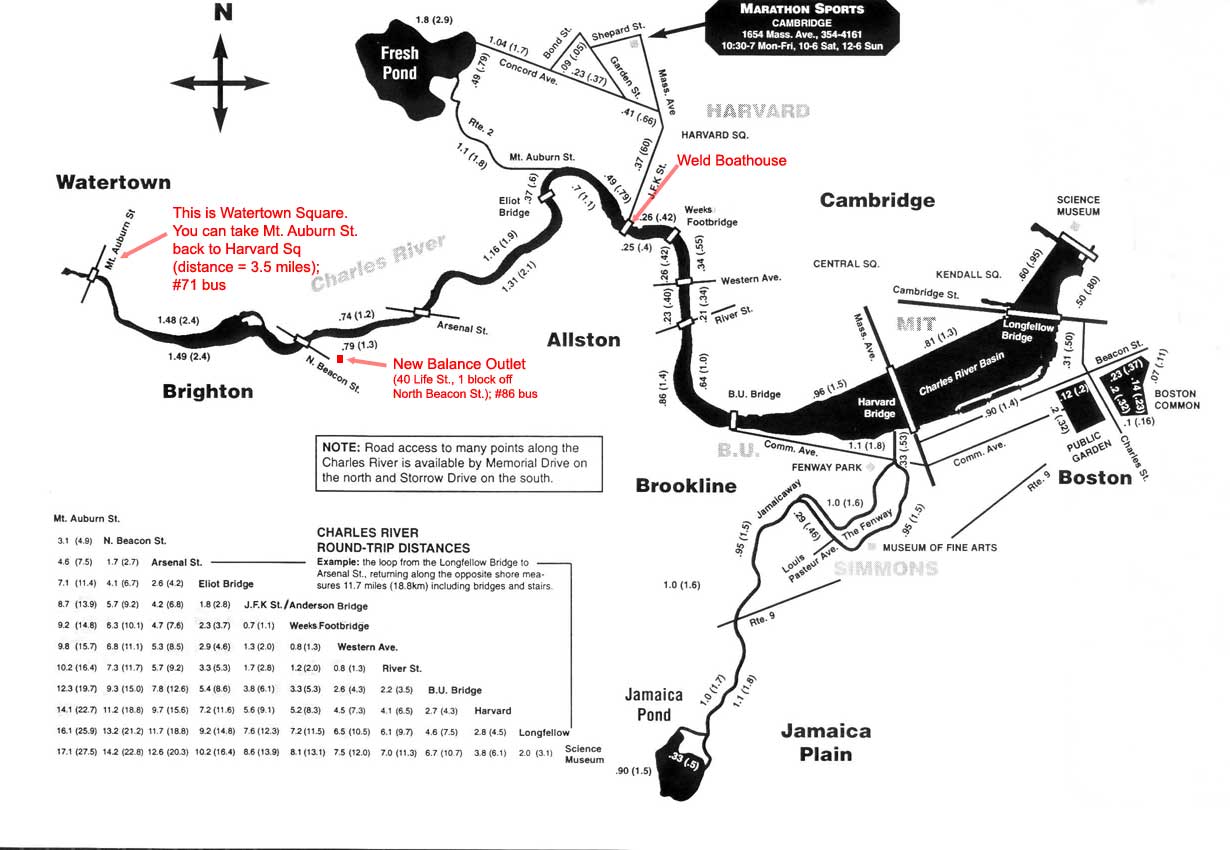
- Map of local Charles River crossings – Harvard College Marathon Challenge website