

List of county exclaves in England and Wales 1844 - 1974
Encyclopedia
Until 1844 many of the counties in England
and Wales
had exclaves or detached parts, entirely surrounded by other counties. Most of these were dealt with by the Counties (Detached Parts) Act 1844
, when they were absorbed by the county in which they were locally situated. Nevertheless, a number of exclaves remained. These were dealt with in a piecemeal manner over a period of decades.
The Local Government Act 1894
empowered the county council
s of administrative counties
to exchange areas in order to make a more effective local government area. As the Local Government Act 1888
had redefined the lieutenancy
and shrievalty
to be based on administrative counties, the changes also affected them as well as judicial boundaries. Accordingly, many anomalies in county boundaries were removed in the next three years, including the elimination of outlying areas of Derbyshire
and Huntingdonshire
.
The last major transfer of areas was in 1931, when the boundaries of Gloucestershire
, Warwickshire
and Worcestershire
were realigned. Following the creation of a new administrative county of Huntingdon and Peterborough
in 1965, and boundary changes at Dudley
in 1966, Flintshire
was left as the only county with detached areas — these remained right up to the abolition of the county council in 1974.
was transferred to Denbighshire
and the urban district of Colwyn Bay
in 1923.
Derbyshire
Flintshire
Flintshire was unique in maintaining exclaves until 1974.
Gloucestershire
After 1844 Gloucestershire had no detached parts, although the areas that became Campden Rural District
and Pebworth Rural District
were only joined to the rest of the county by narrow necks of land. In 1931 the county's boundaries with Warwickshire
and Worcestershire
were realigned, removing the narrow salients from Gloucestershire, while it gained a number of detached Worcestershire
parishes.
Herefordshire
The detached parish of Fwthog was transferred to Monmouthshire
in 1891.
Huntingdonshire
Lancashire
Lees Urban District
was an exclave of the administrative county of Lancashire, being separated from the rest of the county by the County Borough of Oldham
, and enclosed on the other side by Saddleworth Urban District in the West Riding of Yorkshire
.
Additionally, the North Lonsdale
area of Lancashire, or "Lancashire north of the sands", was cut off from the main body of Lancashire by Westmorland
and Morecambe Bay
.
County of London
When the county was formed in 1889 it was made up of a number of parishes in Kent
, Surrey
and Middlesex
. One parish in the last county, Clerkenwell
, had a detached part which became an exclave of London
surrounded by Middlesex. The area — Alexandra Park
— was absorbed by Middlesex in 1899.
Middlesex
Until 1889, Middlesex did not have any detached parts, but the formation of the County of London
left two small exclaves of the parish and urban district of South Hornsey
surrounded by the new county. This situation lasted until 1899, when the whole of South Hornsey passed to the County of London. At the same time, Alexandra Park
, an outlier of the parish of Clerkenwell
in London was transferred to Middlesex.
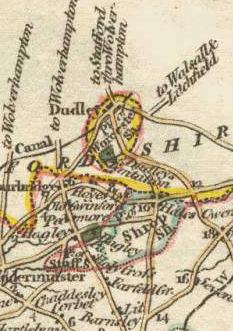
Staffordshire
In 1889 the extra-parochial place of Dudley Castle
, formerly in Worcestershire
, became a detached part of Staffordshire
, surrounded by the county borough
of Dudley
, itself a detached part of Worcestershire
. In 1894 the area became the only parish in Dudley Rural District. In 1929 it was absorbed by the civil parish and county borough of Dudley
, Worcestershire
.
Warwickshire
Ilmington
, Stretton-on-Fosse
and Whitchurch
formed a detached part of Warwickshire, separated from the main part of the county by an exclave of four Worcestershire
parishes. In 1931 the intervening area of Worcestershire was transferred to Warwickshire, so that the three parishes became joined to the rest of the county.
Worcestershire
England
England is a country that is part of the United Kingdom. It shares land borders with Scotland to the north and Wales to the west; the Irish Sea is to the north west, the Celtic Sea to the south west, with the North Sea to the east and the English Channel to the south separating it from continental...
and Wales
Wales
Wales is a country that is part of the United Kingdom and the island of Great Britain, bordered by England to its east and the Atlantic Ocean and Irish Sea to its west. It has a population of three million, and a total area of 20,779 km²...
had exclaves or detached parts, entirely surrounded by other counties. Most of these were dealt with by the Counties (Detached Parts) Act 1844
Counties (Detached Parts) Act 1844
The Counties Act 1844 , which came into effect on 20 October 1844, was an Act of Parliament of the United Kingdom which eliminated many outliers or exclaves of counties in England and Wales for civil purposes....
, when they were absorbed by the county in which they were locally situated. Nevertheless, a number of exclaves remained. These were dealt with in a piecemeal manner over a period of decades.
The Local Government Act 1894
Local Government Act 1894
The Local Government Act 1894 was an Act of the Parliament of the United Kingdom that reformed local government in England and Wales outside the County of London. The Act followed the reforms carried out at county level under the Local Government Act 1888...
empowered the county council
County council
A county council is the elected administrative body governing an area known as a county. This term has slightly different meanings in different countries.-United Kingdom:...
s of administrative counties
Administrative county
An administrative county was an administrative division in England and Wales and Ireland used for the purposes of local government. They are now abolished, although in Northern Ireland their former areas are used as the basis for lieutenancy....
to exchange areas in order to make a more effective local government area. As the Local Government Act 1888
Local Government Act 1888
The Local Government Act 1888 was an Act of the Parliament of the United Kingdom, which established county councils and county borough councils in England and Wales...
had redefined the lieutenancy
Lord Lieutenant
The title Lord Lieutenant is given to the British monarch's personal representatives in the United Kingdom, usually in a county or similar circumscription, with varying tasks throughout history. Usually a retired local notable, senior military officer, peer or business person is given the post...
and shrievalty
Sheriff
A sheriff is in principle a legal official with responsibility for a county. In practice, the specific combination of legal, political, and ceremonial duties of a sheriff varies greatly from country to country....
to be based on administrative counties, the changes also affected them as well as judicial boundaries. Accordingly, many anomalies in county boundaries were removed in the next three years, including the elimination of outlying areas of Derbyshire
Derbyshire
Derbyshire is a county in the East Midlands of England. A substantial portion of the Peak District National Park lies within Derbyshire. The northern part of Derbyshire overlaps with the Pennines, a famous chain of hills and mountains. The county contains within its boundary of approx...
and Huntingdonshire
Huntingdonshire
Huntingdonshire is a local government district of Cambridgeshire, covering the area around Huntingdon. Traditionally it is a county in its own right...
.
The last major transfer of areas was in 1931, when the boundaries of Gloucestershire
Gloucestershire
Gloucestershire is a county in South West England. The county comprises part of the Cotswold Hills, part of the flat fertile valley of the River Severn, and the entire Forest of Dean....
, Warwickshire
Warwickshire
Warwickshire is a landlocked non-metropolitan county in the West Midlands region of England. The county town is Warwick, although the largest town is Nuneaton. The county is famous for being the birthplace of William Shakespeare...
and Worcestershire
Worcestershire
Worcestershire is a non-metropolitan county, established in antiquity, located in the West Midlands region of England. For Eurostat purposes it is a NUTS 3 region and is one of three counties that comprise the "Herefordshire, Worcestershire and Warwickshire" NUTS 2 region...
were realigned. Following the creation of a new administrative county of Huntingdon and Peterborough
Huntingdon and Peterborough
Huntingdon and Peterborough was a short-lived administrative county in East Anglia in the United Kingdom. It existed from 1965 to 1974, when it became part of Cambridgeshire.-Formation:...
in 1965, and boundary changes at Dudley
Dudley
Dudley is a large town in the West Midlands county of England. At the 2001 census , the Dudley Urban Sub Area had a population of 194,919, making it the 26th largest settlement in England, the second largest town in the United Kingdom behind Reading, and the largest settlement in the UK without...
in 1966, Flintshire
Flintshire
Flintshire is a county in north-east Wales. It borders Denbighshire, Wrexham and the English county of Cheshire. It is named after the historic county of Flintshire, which had notably different borders...
was left as the only county with detached areas — these remained right up to the abolition of the county council in 1974.
Caernarvonshire
The detached parish of LlysfaenLlysfaen
Llysfaen is a village in Conwy County Borough near the coast of north Wales and is located high above the coast. For local government purposes, it is also a community and Conwy County Borough Council ward.-Introduction:...
was transferred to Denbighshire
Denbighshire
Denbighshire is a county in north-east Wales. It is named after the historic county of Denbighshire, but has substantially different borders. Denbighshire has the distinction of being the oldest inhabited part of Wales. Pontnewydd Palaeolithic site has remains of Neanderthals from 225,000 years...
and the urban district of Colwyn Bay
Colwyn Bay
- Demography :Prior to local government reorganisation on 1 April 1974 Colwyn Bay was a municipal borough with a population of c.25,000, but in 1974 this designation disappeared leaving five separate parishes, known as communities in Wales, of which the one bearing the name Colwyn Bay encompassed...
in 1923.
DerbyshireDerbyshireDerbyshire is a county in the East Midlands of England. A substantial portion of the Peak District National Park lies within Derbyshire. The northern part of Derbyshire overlaps with the Pennines, a famous chain of hills and mountains. The county contains within its boundary of approx...
- In 1884 the three separate detached parts of the parish of PackingtonPackingtonPackington is a village and civil parish in the district of North West Leicestershire. It is situated close to the A42 road and the town of Ashby de la Zouch. The population of Packington according to the 2001 UK census is 738...
, including the chapelry of SnibstonSnibstonSnibston is a former coal mining village in Coalville, north west Leicestershire, in the English Midlands, now part of the civil parish of Ravenstone with Snibston. Its 13th century church of St Mary is the smallest church still in use for regular worship in England...
were transferred to LeicestershireLeicestershireLeicestershire is a landlocked county in the English Midlands. It takes its name from the heavily populated City of Leicester, traditionally its administrative centre, although the City of Leicester unitary authority is today administered separately from the rest of Leicestershire...
, where they formed part of the new parish of Ravenstone with Snibston. - A block of parishes: Appleby Magna NorthAppleby MagnaAppleby Magna is a village and civil parish in the district of North West Leicestershire, England.The civil parish, as well as Appleby Magna, includes the small Hamlet of Appleby Parva and the Villages of Norton-Juxta-Twycross, Snarestone and Swepstone...
, ChilcoteChilcoteChilcote is a village and civil parish in the North West Leicestershire district of Leicestershire, England. Until 1897 it was in Derbyshire. The parish had a population of 108 according to the 2001 census.-External links:...
, MeashamMeashamMeasham is a village in Leicestershire, near the Staffordshire and Derbyshire border, located just off the A42 just south of Ashby-de-la-Zouch, and within the National Forest...
, Oakthorpe and DonisthorpeOakthorpe and DonisthorpeOakthorpe and Donisthorpe is civil parish in the North West Leicestershire district of Leicestershire, England. According to the 2001 census it had a population of 2336. It includes Oakthorpe and Donisthorpe....
(partly in LeicestershireLeicestershireLeicestershire is a landlocked county in the English Midlands. It takes its name from the heavily populated City of Leicester, traditionally its administrative centre, although the City of Leicester unitary authority is today administered separately from the rest of Leicestershire...
), Stretton en le FieldStretton en le FieldStretton en le Field is a civil parish and hamlet in the North West Leicestershire district of Leicestershire, England. It is about seven miles south-west of Ashby de la Zouch, and according to the 2001 census the parish had a population of 36....
and WillesleyWillesleyWillesley is a place near Ashby-de-la-Zouch. It was in Derbyshire but is now part of Leicestershire. In the 19th century it had a population of about 60 and Willesley Hall was the home of the Abney and later the Abney-Hastings family. Willesley is so small that it would be a hamlet except that it...
transferred to LeicestershireLeicestershireLeicestershire is a landlocked county in the English Midlands. It takes its name from the heavily populated City of Leicester, traditionally its administrative centre, although the City of Leicester unitary authority is today administered separately from the rest of Leicestershire...
1897. At the same time the parishes of NethersealNethersealNetherseal is the southernmost village of the English county of Derbyshire, less than 2 miles from the neighbouring county of Leicestershire, and is close to the A444 and the important M42 motorway, on the banks of the River Mease.It is the final resting place of Sir Nigel Gresley and the...
and OversealOversealOverseal is a village situated 3 miles south of Swadlincote, in South Derbyshire. It is sometimes locally pronounced as "Ovversale" and is the southernmost settlement in Derbyshire, on the border with Leicestershire.-Geography:...
were received from LeicestershireLeicestershireLeicestershire is a landlocked county in the English Midlands. It takes its name from the heavily populated City of Leicester, traditionally its administrative centre, although the City of Leicester unitary authority is today administered separately from the rest of Leicestershire...
.
FlintshireFlintshire (historic)Flintshire , also known as the County of Flint, is one of thirteen historic counties, a vice-county and a former administrative county, which mostly lies on the north east coast of Wales....
Flintshire was unique in maintaining exclaves until 1974.- The largest of these was the area of Maelor Saesneg, which became the Overton Rural DistrictMaelor Rural DistrictMaelor was a rural district in the administrative county of Flintshire, Wales, from 1894 to 1974. The area approximated to the hundred of Maelor or Maelor Saesneg, and was notable for forming a detached part of the county, surrounded by Cheshire, Denbighshire and Shropshire.The district was formed...
in 1894, and was renamed Maelor Rural DistrictMaelor Rural DistrictMaelor was a rural district in the administrative county of Flintshire, Wales, from 1894 to 1974. The area approximated to the hundred of Maelor or Maelor Saesneg, and was notable for forming a detached part of the county, surrounded by Cheshire, Denbighshire and Shropshire.The district was formed...
in 1953. - The other area was the township of Marford and HoselyMarfordMarford, near Wrexham, is a village in the county borough of Wrexham in Wales. It has been described as "a delightful Gothick estate village" and several of its cottages have been listed by Cadw....
, in the parish of Gresford (otherwise in DenbighshireDenbighshireDenbighshire is a county in north-east Wales. It is named after the historic county of Denbighshire, but has substantially different borders. Denbighshire has the distinction of being the oldest inhabited part of Wales. Pontnewydd Palaeolithic site has remains of Neanderthals from 225,000 years...
). Originally this included five separate exclaves, but exchanges with Denbighshire in 1885 reduced the area to a single outlierOutlierIn statistics, an outlier is an observation that is numerically distant from the rest of the data. Grubbs defined an outlier as: An outlying observation, or outlier, is one that appears to deviate markedly from other members of the sample in which it occurs....
. Marford and Hosely became a parishParishA parish is a territorial unit historically under the pastoral care and clerical jurisdiction of one parish priest, who might be assisted in his pastoral duties by a curate or curates - also priests but not the parish priest - from a more or less central parish church with its associated organization...
in the Hawarden Rural District in 1894, although surrounded by Wrexham Rural DistrictWrexham Rural DistrictWrexham was a rural district in the administrative county of Denbighshire from 1894 and 1974.The rural district took over the of the existing Wrexham Rural Sanitary District...
in DenbighshireDenbighshireDenbighshire is a county in north-east Wales. It is named after the historic county of Denbighshire, but has substantially different borders. Denbighshire has the distinction of being the oldest inhabited part of Wales. Pontnewydd Palaeolithic site has remains of Neanderthals from 225,000 years...
. It remained an exclave until local government reorganisation in 1974, when the two rural districts were united in Wrexham MaelorWrexham MaelorWrexham Maelor was one of six local government districts of the county of Clwyd, north-east Wales, from 1974 to 1996.It was formed from parts of the administrative counties of Denbighshire and Flintshire....
.
GloucestershireGloucestershireGloucestershire is a county in South West England. The county comprises part of the Cotswold Hills, part of the flat fertile valley of the River Severn, and the entire Forest of Dean....
After 1844 Gloucestershire had no detached parts, although the areas that became Campden Rural DistrictCampden Rural District
Campden was, from 1894 to 1935, a rural district in the administrative county of Gloucestershire, England. The district lay on the north-eastern boundary of the Gloucestershire, and consisted of three separate areas nearly surrounded by the counties of Warwickshire and Worcestershire...
and Pebworth Rural District
Pebworth Rural District
Pebworth was, from 1894 to 1931, a rural district in the administrative county of Gloucestershire, England. The district consisted of four parts, divided from each other by a section of Worcestershire.-Formation:...
were only joined to the rest of the county by narrow necks of land. In 1931 the county's boundaries with Warwickshire
Warwickshire
Warwickshire is a landlocked non-metropolitan county in the West Midlands region of England. The county town is Warwick, although the largest town is Nuneaton. The county is famous for being the birthplace of William Shakespeare...
and Worcestershire
Worcestershire
Worcestershire is a non-metropolitan county, established in antiquity, located in the West Midlands region of England. For Eurostat purposes it is a NUTS 3 region and is one of three counties that comprise the "Herefordshire, Worcestershire and Warwickshire" NUTS 2 region...
were realigned, removing the narrow salients from Gloucestershire, while it gained a number of detached Worcestershire
Worcestershire
Worcestershire is a non-metropolitan county, established in antiquity, located in the West Midlands region of England. For Eurostat purposes it is a NUTS 3 region and is one of three counties that comprise the "Herefordshire, Worcestershire and Warwickshire" NUTS 2 region...
parishes.
HerefordshireHerefordshireHerefordshire is a historic and ceremonial county in the West Midlands region of England. For Eurostat purposes it is a NUTS 3 region and is one of three counties that comprise the "Herefordshire, Worcestershire and Gloucestershire" NUTS 2 region. It also forms a unitary district known as the...
The detached parish of Fwthog was transferred to MonmouthshireMonmouthshire (historic)
Monmouthshire , also known as the County of Monmouth , is one of thirteen ancient counties of Wales and a former administrative county....
in 1891.
HuntingdonshireHuntingdonshireHuntingdonshire is a local government district of Cambridgeshire, covering the area around Huntingdon. Traditionally it is a county in its own right...
- The parish of SwinesheadSwineshead, BedfordshireSwineshead is a civil parish in the borough of Bedford in the county of Bedfordshire, England.-History:The parish of Swineshead is recorded as Suineshefet , Swynesheved , Swineshead . It was an exclave of the county of Huntingdonshire, and surrounded by Bedfordshire, until 1888 or 1896, when it was...
was a detached part of the county surrounded by BedfordshireBedfordshireBedfordshire is a ceremonial county of historic origin in England that forms part of the East of England region.It borders Cambridgeshire to the north-east, Northamptonshire to the north, Buckinghamshire to the west and Hertfordshire to the south-east....
. In 1896 the parish was transferred to BedfordshireBedfordshireBedfordshire is a ceremonial county of historic origin in England that forms part of the East of England region.It borders Cambridgeshire to the north-east, Northamptonshire to the north, Buckinghamshire to the west and Hertfordshire to the south-east....
, in exchange for the parish of TilbrookTilbrookTilbrook – in Huntingdonshire , England – is a village near Covington west of Huntingdon.-External links:**...
. - Part of the parish of TetworthTetworthTetworth – in Huntingdonshire , England – is a small village near Waresley south of St Neots.Tetworth is in the ward of Gransden and the Offords in the District of Huntingdonshire.-History:...
was an exclave of Huntingdonshire, separated from the rest of the county by a salientSalientSalient may refer to:* See Salients, re-entrants and pockets for the battlefield feature* Salient , part of a discrete territory projecting out of the main portion, bordered by foreign territory on three sides, into which it projects...
of CambridgeshireCambridgeshireCambridgeshire is a county in England, bordering Lincolnshire to the north, Norfolk to the northeast, Suffolk to the east, Essex and Hertfordshire to the south, and Bedfordshire and Northamptonshire to the west...
. This situation remained until 1965, when the county of Huntingdon and PeterboroughHuntingdon and PeterboroughHuntingdon and Peterborough was a short-lived administrative county in East Anglia in the United Kingdom. It existed from 1965 to 1974, when it became part of Cambridgeshire.-Formation:...
was formed, and parish and county boundaries adjusted to remove the detached part.
LancashireLancashireLancashire is a non-metropolitan county of historic origin in the North West of England. It takes its name from the city of Lancaster, and is sometimes known as the County of Lancaster. Although Lancaster is still considered to be the county town, Lancashire County Council is based in Preston...
Lees Urban DistrictLees Urban District
Lees was from 1894 to 1974, a local government district in the administrative county of Lancashire, England.It was created an urban district in 1894 by the Local Government Act 1894 and included the civil parish of Lees and part of the Crossbank hamlet...
was an exclave of the administrative county of Lancashire, being separated from the rest of the county by the County Borough of Oldham
County Borough of Oldham
Oldham was, from 1849 to 1974, a local government district in the northwest of England coterminate with the town of Oldham.-Improvement Commissioners:...
, and enclosed on the other side by Saddleworth Urban District in the West Riding of Yorkshire
West Riding of Yorkshire
The West Riding of Yorkshire is one of the three historic subdivisions of Yorkshire, England. From 1889 to 1974 the administrative county, County of York, West Riding , was based closely on the historic boundaries...
.
Additionally, the North Lonsdale
Furness
Furness is a peninsula in south Cumbria, England. At its widest extent, it is considered to cover the whole of North Lonsdale, that part of the Lonsdale hundred that is an exclave of the historic county of Lancashire, lying to the north of Morecambe Bay....
area of Lancashire, or "Lancashire north of the sands", was cut off from the main body of Lancashire by Westmorland
Westmorland
Westmorland is an area of North West England and one of the 39 historic counties of England. It formed an administrative county from 1889 to 1974, after which the entirety of the county was absorbed into the new county of Cumbria.-Early history:...
and Morecambe Bay
Morecambe Bay
Morecambe Bay is a large bay in northwest England, nearly due east of the Isle of Man and just to the south of the Lake District National Park. It is the largest expanse of intertidal mudflats and sand in the United Kingdom, covering a total area of 310 km².-Natural features:The rivers Leven,...
.
County of LondonCounty of LondonThe County of London was a county of England from 1889 to 1965, corresponding to the area known today as Inner London. It was created as part of the general introduction of elected county government in England, by way of the Local Government Act 1888. The Act created an administrative County of...
When the county was formed in 1889 it was made up of a number of parishes in KentKent
Kent is a county in southeast England, and is one of the home counties. It borders East Sussex, Surrey and Greater London and has a defined boundary with Essex in the middle of the Thames Estuary. The ceremonial county boundaries of Kent include the shire county of Kent and the unitary borough of...
, Surrey
Surrey
Surrey is a county in the South East of England and is one of the Home Counties. The county borders Greater London, Kent, East Sussex, West Sussex, Hampshire and Berkshire. The historic county town is Guildford. Surrey County Council sits at Kingston upon Thames, although this has been part of...
and Middlesex
Middlesex
Middlesex is one of the historic counties of England and the second smallest by area. The low-lying county contained the wealthy and politically independent City of London on its southern boundary and was dominated by it from a very early time...
. One parish in the last county, Clerkenwell
Clerkenwell
Clerkenwell is an area of central London in the London Borough of Islington. From 1900 to 1965 it was part of the Metropolitan Borough of Finsbury. The well after which it was named was rediscovered in 1924. The watchmaking and watch repairing trades were once of great importance...
, had a detached part which became an exclave of London
County of London
The County of London was a county of England from 1889 to 1965, corresponding to the area known today as Inner London. It was created as part of the general introduction of elected county government in England, by way of the Local Government Act 1888. The Act created an administrative County of...
surrounded by Middlesex. The area — Alexandra Park
Alexandra Park, London
Alexandra Park is an 80 hectare, Green Flag Award and Green Heritage winning landscaped park in the Borough of Haringey in north London.-Overview:...
— was absorbed by Middlesex in 1899.
MiddlesexMiddlesexMiddlesex is one of the historic counties of England and the second smallest by area. The low-lying county contained the wealthy and politically independent City of London on its southern boundary and was dominated by it from a very early time...
Until 1889, Middlesex did not have any detached parts, but the formation of the County of LondonCounty of London
The County of London was a county of England from 1889 to 1965, corresponding to the area known today as Inner London. It was created as part of the general introduction of elected county government in England, by way of the Local Government Act 1888. The Act created an administrative County of...
left two small exclaves of the parish and urban district of South Hornsey
South Hornsey
South Hornsey was a local government district in Middlesex, England from 1865 to 1900.The district was formed in 1865 when the Local Government Act 1858 was adopted in the southern part of the parish of Hornsey. South Hornsey Local Board was formed to govern the area.The majority of the district ...
surrounded by the new county. This situation lasted until 1899, when the whole of South Hornsey passed to the County of London. At the same time, Alexandra Park
Alexandra Park, London
Alexandra Park is an 80 hectare, Green Flag Award and Green Heritage winning landscaped park in the Borough of Haringey in north London.-Overview:...
, an outlier of the parish of Clerkenwell
Clerkenwell
Clerkenwell is an area of central London in the London Borough of Islington. From 1900 to 1965 it was part of the Metropolitan Borough of Finsbury. The well after which it was named was rediscovered in 1924. The watchmaking and watch repairing trades were once of great importance...
in London was transferred to Middlesex.
StaffordshireStaffordshireStaffordshire is a landlocked county in the West Midlands region of England. For Eurostat purposes, the county is a NUTS 3 region and is one of four counties or unitary districts that comprise the "Shropshire and Staffordshire" NUTS 2 region. Part of the National Forest lies within its borders...
In 1889 the extra-parochial place of Dudley CastleDudley Castle
Dudley Castle is a ruined castle in the town of Dudley, West Midlands, England. Dudley Zoo is located in its grounds. The location, Castle Hill, is an outcrop of Wenlock Group limestone that was extensively quarried during the Industrial Revolution, and which now along with Wren's Nest Hill is a...
, formerly in Worcestershire
Worcestershire
Worcestershire is a non-metropolitan county, established in antiquity, located in the West Midlands region of England. For Eurostat purposes it is a NUTS 3 region and is one of three counties that comprise the "Herefordshire, Worcestershire and Warwickshire" NUTS 2 region...
, became a detached part of Staffordshire
Staffordshire
Staffordshire is a landlocked county in the West Midlands region of England. For Eurostat purposes, the county is a NUTS 3 region and is one of four counties or unitary districts that comprise the "Shropshire and Staffordshire" NUTS 2 region. Part of the National Forest lies within its borders...
, surrounded by the county borough
County borough
County borough is a term introduced in 1889 in the United Kingdom of Great Britain and Ireland , to refer to a borough or a city independent of county council control. They were abolished by the Local Government Act 1972 in England and Wales, but continue in use for lieutenancy and shrievalty in...
of Dudley
Dudley
Dudley is a large town in the West Midlands county of England. At the 2001 census , the Dudley Urban Sub Area had a population of 194,919, making it the 26th largest settlement in England, the second largest town in the United Kingdom behind Reading, and the largest settlement in the UK without...
, itself a detached part of Worcestershire
Worcestershire
Worcestershire is a non-metropolitan county, established in antiquity, located in the West Midlands region of England. For Eurostat purposes it is a NUTS 3 region and is one of three counties that comprise the "Herefordshire, Worcestershire and Warwickshire" NUTS 2 region...
. In 1894 the area became the only parish in Dudley Rural District. In 1929 it was absorbed by the civil parish and county borough of Dudley
Dudley
Dudley is a large town in the West Midlands county of England. At the 2001 census , the Dudley Urban Sub Area had a population of 194,919, making it the 26th largest settlement in England, the second largest town in the United Kingdom behind Reading, and the largest settlement in the UK without...
, Worcestershire
Worcestershire
Worcestershire is a non-metropolitan county, established in antiquity, located in the West Midlands region of England. For Eurostat purposes it is a NUTS 3 region and is one of three counties that comprise the "Herefordshire, Worcestershire and Warwickshire" NUTS 2 region...
.
WarwickshireWarwickshireWarwickshire is a landlocked non-metropolitan county in the West Midlands region of England. The county town is Warwick, although the largest town is Nuneaton. The county is famous for being the birthplace of William Shakespeare...
IlmingtonIlmington
Ilmington is a village and civil parish about north-west of Shipston-on-Stour and south of Stratford-on-Avon in the Cotswolds in Warwickshire, England. Ilmington is the highest village in Warwickshire and is at the foot of the Ilmington Downs, which is the highest point in Warwickshire...
, Stretton-on-Fosse
Stretton-on-Fosse
Stretton-on-Fosse is a small village and civil parish with fewer than 200 houses, most built of Cotswold stone or locally-made red brick, situated on the Warwickshire-Gloucestershire border on the fringe of the Cotswold Hills.-History:...
and Whitchurch
Whitchurch, Warwickshire
Whitchurch is a small hamlet south of Stratford-upon-Avon in Warwickshire, England. it used to be a detached part of Worcestershire until 1931.It consists of 5 properties. There are 19 people living in Whitchurch....
formed a detached part of Warwickshire, separated from the main part of the county by an exclave of four Worcestershire
Worcestershire
Worcestershire is a non-metropolitan county, established in antiquity, located in the West Midlands region of England. For Eurostat purposes it is a NUTS 3 region and is one of three counties that comprise the "Herefordshire, Worcestershire and Warwickshire" NUTS 2 region...
parishes. In 1931 the intervening area of Worcestershire was transferred to Warwickshire, so that the three parishes became joined to the rest of the county.
WorcestershireWorcestershireWorcestershire is a non-metropolitan county, established in antiquity, located in the West Midlands region of England. For Eurostat purposes it is a NUTS 3 region and is one of three counties that comprise the "Herefordshire, Worcestershire and Warwickshire" NUTS 2 region...
- The parish of Edvin LoachEdvin LoachEdvin Loach, also Edwin Loach, is a village in eastern Herefordshire, England, about four miles north of the town of Bromyard, and near the village of Edwin Ralph...
was transferred to HerefordshireHerefordshireHerefordshire is a historic and ceremonial county in the West Midlands region of England. For Eurostat purposes it is a NUTS 3 region and is one of three counties that comprise the "Herefordshire, Worcestershire and Gloucestershire" NUTS 2 region. It also forms a unitary district known as the...
in 1893 - CutsdeanCutsdeanCutsdean is a small village in the Cotswolds, located close to the Gloucestershire town of Cheltenham. The River Windrush runs through the village.-External links:...
, originally a chapelry in the parish of Bredon, became a civil parish in 1866. Transferred to WorcestershireWorcestershireWorcestershire is a non-metropolitan county, established in antiquity, located in the West Midlands region of England. For Eurostat purposes it is a NUTS 3 region and is one of three counties that comprise the "Herefordshire, Worcestershire and Warwickshire" NUTS 2 region...
1931 - BlockleyBlockleyBlockley is a village and civil parish in the Cotswold district of Gloucestershire, England, about northwest of Moreton-in-Marsh. Until 1931 Blockley was an exclave of Worcestershire....
parish transferred to GloucestershireGloucestershireGloucestershire is a county in South West England. The county comprises part of the Cotswold Hills, part of the flat fertile valley of the River Severn, and the entire Forest of Dean....
in 1931. - DaylesfordDaylesford, GloucestershireDaylesford is a small village in Gloucestershire, England, on the border with Oxfordshire. It is situated off the A436 near Stow-on-the-Wold and five miles west of Chipping Norton. The village is on the north bank of the small River Evenlode...
parish transferred to GloucestershireGloucestershireGloucestershire is a county in South West England. The county comprises part of the Cotswold Hills, part of the flat fertile valley of the River Severn, and the entire Forest of Dean....
in 1931. - Evenlode parish transferred to GloucestershireGloucestershireGloucestershire is a county in South West England. The county comprises part of the Cotswold Hills, part of the flat fertile valley of the River Severn, and the entire Forest of Dean....
in 1931. - AlderminsterAlderminsterAlderminster is a village and civil parish in the Stratford-on-Avon district of Warwickshire, England. It is on the River Stour and the A3400, between Stratford-upon-Avon and Shipston-on-Stour. Nearby places are Wimpstone, Atherstone-on-Stour and Newbold-on-Stour...
, Shipston-on-StourShipston-on-StourShipston-on-Stour is a town and civil parish on the River Stour about south of Stratford-upon-Avon in Warwickshire. It is in the northern part of the Cotswolds, close to the boundaries with Oxfordshire and Gloucestershire....
, Tidmington and TredingtonTredington, WarwickshireTredington is a small village near Shipston-on-Stour in Warwickshire.The village has a primary School, a church, and a pub, and it used to have a village shop although this is now closed....
parishes became (with Blockley) Shipston-on-Stour Rural DistrictShipston-on-Stour Rural DistrictShipston on Stour was a rural district in England from 1894 to 1974. The district covered an area around Shipston-on-Stour. Originally it was a detached part of Worcestershire, but in 1931 it was transferred to the jurisdiction of Warwickshire, and was expanded by the abolition of Brailes Rural...
in 1894. Transferred to WarwickshireWarwickshireWarwickshire is a landlocked non-metropolitan county in the West Midlands region of England. The county town is Warwick, although the largest town is Nuneaton. The county is famous for being the birthplace of William Shakespeare...
1931. - DudleyDudleyDudley is a large town in the West Midlands county of England. At the 2001 census , the Dudley Urban Sub Area had a population of 194,919, making it the 26th largest settlement in England, the second largest town in the United Kingdom behind Reading, and the largest settlement in the UK without...
in 1889 became a county borough, but remained a detached part of WorcestershireWorcestershireWorcestershire is a non-metropolitan county, established in antiquity, located in the West Midlands region of England. For Eurostat purposes it is a NUTS 3 region and is one of three counties that comprise the "Herefordshire, Worcestershire and Warwickshire" NUTS 2 region...
for non-administrative reasons. In 1966 the county borough absorbed surrounding areas of the administrative county of StaffordshireStaffordshireStaffordshire is a landlocked county in the West Midlands region of England. For Eurostat purposes, the county is a NUTS 3 region and is one of four counties or unitary districts that comprise the "Shropshire and Staffordshire" NUTS 2 region. Part of the National Forest lies within its borders...
, and from that date was included in the latter county.