
List of State Routes in Connecticut
Encyclopedia
The Connecticut Department of Transportation
(ConnDOT) maintains a system of state highway
s to serve the predominant flow of traffic between towns
within Connecticut
, and to towns in surrounding states. State highways also include roads that provide access to federal and state facilities (Special Service Roads).
The state highway system consists of roads indicated on the official ConnDOT map and highway log. As of January 1, 2007, the state highway system contains a total of 3719 miles (5,985.1 km) of roads (not including ramps and interchange connections), corresponding to approximately 20% of all roads in the state. All state highways are state-maintained except for several segments (totaling 4 miles) that are locally maintained. All interstate highways and U.S. highways in the state are part of the state highway system.
All state highways are given a number designation. Most state highways are assigned Route numbers (including U.S. highways and interstates). Route numbers are in the 1-399 range, with the exception of Interstates 684
and 691
. State highways that are special service roads are assigned SSR numbers and are unsigned. SSR numbers are in the 400-499 range. Another set of unsigned state highways are called State Roads and are given SR numbers. These state roads are either feeder roads that interconnect state highways together, or long entry/exit ramps to freeways (often called connector roads). SR numbers are in the 500-999 range. Signposted state highways that are not U.S. highways or interstates are signed with the square Connecticut state highway shield.
 In 1900, the State Highway Department proposed a statewide system of trunk line routes. By 1913, the system consisted of 10 north-south highways and 4 east-west highways, including the lower Boston Post Road
. The system covered roughly 1400 miles (2,253.1 km). The 14 trunk lines were numbered on paper but were never actually signposted. The 14 trunk line routes were:
and consisted of 25 routes (with route numbers from 1 to 32). A total of 9 of the routes passed through Connecticut (Routes 1
, 2, 3, 4, 8
, 10
, 12
, 17
, and 32
). In this system, inter-state routes would be numbered 1-99 and state routes numbered 100 and up. The New England route system was soon eclipsed by the national U.S. highway system.
Connecticut Department of Transportation
The Connecticut Department of Transportation is responsible for the development and operation of highways, railroads, mass transit systems, ports, waterways and aviation facilities in the U.S. state of Connecticut. The current Commissioner of ConnDOT is Jeffrey Parker...
(ConnDOT) maintains a system of state highway
State highway
State highway, state road or state route can refer to one of three related concepts, two of them related to a state or provincial government in a country that is divided into states or provinces :#A...
s to serve the predominant flow of traffic between towns
New England town
The New England town is the basic unit of local government in each of the six New England states. Without a direct counterpart in most other U.S. states, New England towns are conceptually similar to civil townships in other states, but are incorporated, possessing powers like cities in other...
within Connecticut
Connecticut
Connecticut is a state in the New England region of the northeastern United States. It is bordered by Rhode Island to the east, Massachusetts to the north, and the state of New York to the west and the south .Connecticut is named for the Connecticut River, the major U.S. river that approximately...
, and to towns in surrounding states. State highways also include roads that provide access to federal and state facilities (Special Service Roads).
The state highway system consists of roads indicated on the official ConnDOT map and highway log. As of January 1, 2007, the state highway system contains a total of 3719 miles (5,985.1 km) of roads (not including ramps and interchange connections), corresponding to approximately 20% of all roads in the state. All state highways are state-maintained except for several segments (totaling 4 miles) that are locally maintained. All interstate highways and U.S. highways in the state are part of the state highway system.
All state highways are given a number designation. Most state highways are assigned Route numbers (including U.S. highways and interstates). Route numbers are in the 1-399 range, with the exception of Interstates 684
Interstate 684
Interstate 684 is a 28.4 mile-long north–south Interstate Highway in the states of New York and Connecticut. The highway connects I-84 with I-287 and the Hutchinson River Parkway, primarily serving commuter traffic to and from the northern suburbs of the New York metropolitan area...
and 691
Interstate 691
Interstate 691 is a portion of the Interstate Highway System in Connecticut beginning at Interstate 91 in Meriden and ending at Interstate 84 near the Cheshire-Southington town line. It is in length, including of the exit ramp to the merge with westbound I-84.I-691 is also known as the Henry D...
. State highways that are special service roads are assigned SSR numbers and are unsigned. SSR numbers are in the 400-499 range. Another set of unsigned state highways are called State Roads and are given SR numbers. These state roads are either feeder roads that interconnect state highways together, or long entry/exit ramps to freeways (often called connector roads). SR numbers are in the 500-999 range. Signposted state highways that are not U.S. highways or interstates are signed with the square Connecticut state highway shield.
Routes
Routes are signed state highways and are assigned numbers from 1 to 399 (with the exception of I-684 and I-691). All state, U.S. and Interstate highways are part of the same numbering system.| 1-99 | 100-199 | 200 and up |
|---|---|---|
 U.S. Route 1 U.S. Route 1U.S. Route 1 in Connecticut In the U.S. state of Connecticut, U.S. Route 1 is a major east–west state highway along Long Island Sound. It has been replaced by Interstate 95 as a through route, which it closely parallels, and now primarily serves as a local business route...  U.S. Route 1A U.S. Route 1AU.S. Route 1A U.S. Route 1A is the name of several highways found in the United States:-Wake and Franklin counties, North Carolina:U.S. Route 1A in Wake and Franklin counties, is located north of Raleigh and in two separate segments....  Route 2 Route 2  Route 2A Route 2A  Route 3 Route 3  Route 4 Route 4  U.S. Route 5 U.S. Route 5U.S. Route 5 in Connecticut U.S. Route 5 , a north–south U.S. Highway that is generally paralleled by Interstate 91, begins at the city of New Haven in Connecticut and heads north through western Massachusetts and eastern Vermont to the international border with Canada...  U.S. Route 6 U.S. Route 6U.S. Route 6 in Connecticut U.S. Route 6 is the portion of the cross-country U.S. Route 6 within the state of Connecticut. West of Hartford, the route either closely parallels or runs along Interstate 84. Interstate 84 has largely supplanted Route 6 as a through route in western Connecticut. East of Hartford, the route serves...  U.S. Route 7 in Connecticut In the state of Connecticut, U.S. Route 7 runs from Canaan to Norwalk.-Route description:U.S. 7 in Connecticut is mostly a surface road but has two short expressway sections in the Norwalk and Danbury areas. US 7 begins in Norwalk with a expressway to nearly the Wilton town line...  Route 8 Route 8  Route 9 Route 9  Route 10 Route 10Connecticut Route 10 Connecticut Route 10 is a state highway that runs between New Haven and the state line near Granby.-Route description:Route 10 begins at Interstate 95 as Ella T. Grasso Boulevard in the city of New Haven. It then passes by Southern Connecticut State University before entering the town of Hamden...  Route 11 Route 11  Route 12 Route 12Connecticut Route 12 Connecticut Route 12 is a state highway that runs between Groton and the state line near Thompson.-History:Route 12 was preceded by New England Interstate Route 12. The southern terminus of NE-12 was originally at New London, Connecticut. It travelled along present-day Route 32 from New London to...  Route 14 Route 14  Route 14A Route 14A  Route 15 Route 15  Route 16 Route 16  Route 17 Route 17  Route 17A Route 17A  Route 19 Route 19  Route 20 Route 20  Route 21 Route 21  Route 22 Route 22  Route 25 Route 25  Route 27 Route 27  Route 30 Route 30  Route 31 Route 31  Route 32 Route 32  Route 33 Route 33  Route 34 Route 34  Route 35 Route 35  Route 37 Route 37Connecticut Route 37 Route 37 is a north–south state highway in Connecticut running for from Route 39 in Danbury, through New Fairfield, to U.S. Route 7 in New Milford...  Route 39 Route 39  Route 40 Route 40  Route 41 Route 41  Route 42 Route 42Connecticut Route 42 Route 42 is an east–west state highway in Connecticut running for from Route 67 in Oxford to Route 10 in Cheshire.- Route description:...  Route 43 Route 43Connecticut Route 43 Route 43 is a Connecticut state highway. It is long and runs north–south within the town of Cornwall. It connects the town center with the village of Cornwall Hollow near the Canaan town line.- Route description:...  U.S. Route 44 U.S. Route 44U.S. Route 44 in Connecticut U.S. Route 44 is an east–west U.S. Highway running from Salisbury to Putnam.-Route description:From the New York state line at Salisbury to the Rhode Island state line at Putnam, US 44 runs for a total of in Connecticut. Most of US 44 is known in the state as the Jonathan Trumbull Highway...  Route 45 Route 45Connecticut Route 45 Route 45 is a Connecticut state highway from US 202 in Washington to US 7 in Cornwall, in the rural northwest of the state. It is long and runs north–south.- Route description:...  Route 47 Route 47Connecticut Route 47 Route 47 is a Connecticut state highway from US 6 in Woodbury to US 202 in Washington, in the west-central part of the state. It is long and runs roughly northwest-southeast, signed north–south.- Route description:...  Route 49 Route 49Connecticut Route 49 Route 49 is a Connecticut state highway from Route 2 in Stonington to Route 14A in Sterling, in the southeast part of the state. It is a scenic route that runs through the Pachaug State Forest.-Route description:...  Route 53 Route 53  Route 55 Route 55  Route 57 Route 57  Route 58 Route 58  Route 59 Route 59Connecticut Route 59 Route 59 is a north–south state highway in Connecticut, running from Bridgeport to Monroe. Between Bridgeport and Easton, Route 59 used to be the Stratfield and Weston Turnpike, which operated from 1797 to 1886...  Route 61 Route 61Connecticut Route 61 Route 61 is a secondary state highway in rural northwestern Connecticut connecting the towns of Woodbury and Morris. It serves as the main north–south highway within the towns of Bethlehem and Morris.-Route description:...  Route 63 Route 63  Route 64 Route 64  Route 66 Route 66  Route 67 Route 67  Route 68 Route 68  Route 69 Route 69  Route 70 Route 70  Route 71 Route 71Connecticut Route 71 Route 71 is a north–south state highway in Connecticut, running from Wallingford to West Hartford. It is the main north–south road of Meriden, Berlin and New Britain.-Route description:...  Route 71A Route 71A  Route 72 Route 72  Route 73 Route 73Connecticut Route 73 Route 73 is an east–west state highway in Connecticut connecting the town center of Watertown to the Route 8 expressway in Waterbury via the village of Oakville...  Route 74 Route 74Connecticut Route 74 Route 74 is a state highway in Connecticut in the eastern part of the Greater Hartford area. It runs from Route 194 in South Windsor to US 44 in Ashford, going through the towns of Ellington, Vernon, Tolland, and Willington...  Route 75 Route 75  Route 77 Route 77Connecticut Route 77 Route 77 is a secondary state highway in southern Connecticut. It is a state-designated scenic road and runs from the Guilford town green, through North Guilford, into the town center of Durham.- Route description:...  Route 78 Route 78  Route 79 Route 79  Route 80 Route 80  Route 81 Route 81Connecticut Route 81 Route 81 is a state highway in Connecticut from Clinton center through Killingworth center to the village of Higganum in the town of Haddam.-Route description:...  Route 82 Route 82Connecticut Route 82 Route 82 is an east–west state highway in Connecticut running for from Route 9 in Chester to Route 2 and 32 in Norwich.- Route description:...  Route 83 Route 83  Interstate 84 Interstate 84Interstate 84 in Connecticut Interstate 84 is an East–West Interstate highway across the state of Connecticut into Danbury, Waterbury, Hartford and Union.-Route description:...  Route 85 Route 85  Route 87 Route 87Connecticut Route 87 Route 87 is a Connecticut state highway running from Franklin to Andover, generally in a southeast-northwest direction. The route is part of the road connecting the towns of Norwich, Lebanon, Columbia, and Andover...  Route 89 Route 89Connecticut Route 89 Route 89 is a state highway in northeastern Connecticut, running from eastern Mansfield to southern Union. It connectes the villages of Mansfield Center, Warrenville, and Westford...  Interstate 91 Interstate 91Interstate 91 in Connecticut Interstate 91 is a north–south Interstate Highway in the state of Connecticut. The interstate's southern end is in New Haven, Connecticut at Interstate 95.-Route description:...  Route 94 Route 94Connecticut Route 94 Route 94 is an east–west state highway in Connecticut running for from Route 2 in Glastonbury to Route 85 in Hebron.- Route description:...  Interstate 95 Interstate 95Interstate 95 in Connecticut Interstate 95, the main north–south Interstate Highway on the East Coast of the United States, runs in a general east–west compass direction for 111.57 miles in Connecticut from the Rhode Island state line to the New York State line. I-95 Southbound from East Lyme to the New York State...  Route 97 Route 97Connecticut Route 97 Route 97 is a north–south state highway in eastern Connecticut running for from Route 12 in Norwich to US 44 in Pomfret.- Route description:...  Route 99 Route 99Connecticut Route 99 Route 99 is a state highway in Connecticut running for from Route 9 in Cromwell, through the town of Rocky Hill, ending in Wethersfield at the Hartford city line. The road continues into Hartford as a local road... |
 Route 100 Route 100  Route 101 Route 101Connecticut Route 101 Route 101 is a state highway in northeastern Connecticut running from Pomfret to the Rhode Island state line in Killingly. The road originated as a 19th-century toll road known as the Connecticut and Rhode Island Turnpike. Route 101 was designated along the modern alignment in 1935 when an earlier...  Route 102 Route 102Connecticut Route 102 Route 102 is a state highway in southwestern Connecticut running from the center of Ridgefield to the Branchville section of the same town.-Route description:...  Route 103 Route 103Connecticut Route 103 Route 103 is a state highway in Connecticut running from the Quinnipiac Meadows neighborhood in New Haven, through the Montowese area of North Haven, ending at the town center of North Haven.-Route description:...  Route 104 Route 104Connecticut Route 104 Route 104 is a Connecticut state highway in the city of Stamford, running from the Westover section of the city to the New York state line in the Long Ridge section of the city.-Route description:...  Route 106 Route 106Connecticut Route 106 Route 106 is a state highway in southwestern Connecticut, running from Stamford to Wilton.-Route description:Route 106 begins at a junction with I-95 and US 1 in the East Side of Stamford as Courtland Avenue then turning right on Glenbrook Road...  Route 107 Route 107Connecticut Route 107 Route 107 is a state highway in southwestern Connecticut, connecting the community of Georgetown to the town center of Redding.-Route description:...  Route 108 Route 108Connecticut Route 108 Route 108 in the U.S. state of Connecticut, also called Huntington Turnpike and Nichols Avenue, is a two-lane state highway that runs northerly from US 1, Boston Post Road in Stratford, through Trumbull, to Route 110 in downtown Shelton...  Route 109 Route 109Connecticut Route 109 Route 109 is a state highway in western Connecticut, running from New Milford to Thomaston.-Route description:Route 109 begins at an intersection with US 202 in New Milford and heads northeast into Washington, where if overlaps Route 47 for before continuing into Morris...  Route 110 Route 110Connecticut Route 110 Route 110 is a state highway in Connecticut running for from US 1 in Stratford to Route 111 in Monroe.-Route description:Route 110 begins at an intersection with US 1 in Stratford and heads north along the west bank of the Housatonic River, intersecting Route 15 before continuing into Shelton...  Route 111 Route 111Connecticut Route 111 Route 111 is a state highway in southwestern Connecticut, United States, running from the Merritt Parkway in Trumbull to Route 34 in Monroe. The junction with the Merritt Parkway is currently the only single-point urban interchange in the entire state....  Route 112 Route 112Connecticut Route 112 Route 112 is a state highway in northwestern Connecticut, running entirely within the town of Salisbury. The route serves the village of Lime Rock.-Route description:...  Route 113 Route 113Connecticut Route 113 Route 113 is a Connecticut state highway running from the Bridgeport-Stratford town line around the Lordship section of Stratford to the eastern part of the town.-Route description:...  Route 114 Route 114Connecticut Route 114 Route 114 is a Connecticut state highway in the western suburbs of New Haven, running from Orange to Woodbridge.-Route description:Route 114 begins as Racebrook Road at an intersection with US 1 in Orange and heads north. It intersects with Route 34 in northern Orange from the south end and...  Route 115 Route 115Connecticut Route 115 Route 115 is a Connecticut state highway in the Lower Naugatuck River Valley area, running from Route 34 in Derby to Route 67 in Seymour. The road runs along the east bank of the lower Naugatuck River.-Route description:...  Route 116 Route 116Connecticut Route 116 Route 116 is a state highway in Connecticut running from the town center of Ridgefield at Route 35, and ending at the New York state line in Ridgefield .-Route description:...  Route 117 Route 117Connecticut Route 117 Route 117 is a state highway in southeastern Connecticut, running from Groton to Preston.-Route description:Route 117 begins at an intersection with US 1 in the village of Poquonnock Bridge in Groton. It starts out as Newtown Road then changes to North Road...  Route 118 Route 118Connecticut Route 118 Route 118 is a state highway in northwestern Connecticut, running from the borough of Litchfield via the village of East Litchfield to the town center of Harwinton.-Route description:...  Route 120 Route 120Connecticut Route 120 Route 120 is a state highway in Connecticut, running entirely in the town of Southington. It serves as a more direct connection between the town center of Southington and the city of Meriden.-Route description:...  Route 121 Route 121  Route 122 Route 122  Route 123 Route 123Connecticut Route 123 Route 123 is a secondary state highway in southwestern Connecticut from Norwalk to the New York state line near the hamlet of Vista .-Route description:...  Route 124 Route 124Connecticut Route 124 Route 124 is a state highway in southwestern Connecticut running from downtown Darien through the center of New Canaan to the state line in Pound Ridge, New York-Route description:...  Route 125 Route 125Connecticut Route 125 Route 125 is a minor state highway in northwestern Connecticut, running entirely within the town of Cornwall.-Route description:Route 125 begins at an intersection with Route 4 in the town center of Cornwall and heads north for to end at an intersection with Route 128...  Route 126 Route 126Connecticut Route 126 Route 126 is a minor state highway in northwestern Connecticut, running from Route 63 in Canaan to U.S. Route 44 in North Canaan.-Route description:...  Route 127 Route 127Connecticut Route 127 Route 127 is a state highway in southwestern Connecticut, running entirely from Bridgeport to Trumbull. It serves as a minor arterial, connecting all four major limited access highways in the Bridgeport area.-Route description:...  Route 128 Route 128Connecticut Route 128 Route 128 is a minor state highway in northwestern Connecticut, running from U.S. Route 7 in Sharon to Route 4 in Cornwall.-Route description:Route 128 begins at an intersection with US 7 on the west bank of the Housatonic River within the town of Sharon...  Route 130 Route 130Connecticut Route 130 Route 130 is a state highway in southwestern Connecticut, running from Fairfield to Stratford, generally parallel to I-95.-Route description:...  Route 131 Route 131  Route 132 Route 132Connecticut Route 132 Route 132 is a state highway in western Connecticut, running from Route 47 in Woodbury, through Bethlehem center, to Route 63 in Watertown.-Route description:...  Route 133 Route 133Connecticut Route 133 Route 133 is a state highway in western Connecticut, running from U.S. Route 202 in Brookfield to Route 67 in Bridgewater.-Route description:Route 133 begins as Junction Road at an intersection with US 202 in western Brookfield. It heads east across the Still River and US 7 without a junction...  Route 135 Route 135Connecticut Route 135 Route 135 is a Connecticut state highway running entirely in the town of Fairfield. It connects U.S. Route 1 in downtown Fairfield to Route 58 in the northern part of town.-Route description:...  Route 136 Route 136Connecticut Route 136 Route 136 is a state highway in southwestern Connecticut, running from Darien to Easton. The route was initially established in 1932 to serve the beach communities between Darien and Southport...  Route 137 Route 137  Route 138 Route 138  Route 139 Route 139Connecticut Route 139 Route 139 is a state highway in southern Connecticut running from Branford to North Branford.-Route description:Route 139 begins as North Branford Road at an intersection with US 1 in the northern part of Branford. It heads northeast, crossing the Branford River soon entering the town of North...  Route 140 Route 140Connecticut Route 140 Route 140 is a state highway in Connecticut in the northeastern part of the Greater Hartford area. Route 140 is a main artery connecting the town of Ellington to Hartford.-Route description:...  Route 142 Route 142  Route 145 Route 145Connecticut Route 145 Route 145 is a state highway in the western part of the Connecticut River Estuary region of Connecticut. It connects Clinton center, through the village of Winthrop, to the town of Chester.- Route description:...  Route 146 Route 146Connecticut Route 146 Route 146 is a state road that serves as a scenic alternative to US 1 between Branford and Guilford in the U.S. state of Connecticut. Route 146 is long, with in Branford and in Guilford.-Route description:...  Route 147 Route 147Connecticut Route 147 Route 147 is a state highway in central Connecticut running from Durham to Middlefield.-Route description:Route 147 begins as Middlefield Road at an intersection with Route 17 just north of the town center of Durham. It heads northwest, crossing into the town of Middlefield after , where the road...  Route 148 Route 148Connecticut Route 148 Route 148 is a state highway in southern and southeastern Connecticut running from Route 79 in Killingworth to Route 82 in the village of Hadlyme...  Route 149 Route 149Connecticut Route 149 Route 149 is a state highway in east-central Connecticut running from Route 82 in East Haddam center to the Colchester-Hebron town line.-Route description:...  Route 150 Route 150Connecticut Route 150 Route 150 is a state highway in southern Connecticut running for from the village of Northford, in the town of North Branford, through the center of Wallingford, to the village of Yalesville in Wallingford.-Route description:...  Route 151 Route 151Connecticut Route 151 Route 151 is a Connecticut state highway in the Connecticut River valley running from East Haddam via Moodus to the village of Cobalt in East Hampton.-Route description:...  Route 152 Route 152  Route 153 Route 153Connecticut Route 153 Route 153 is a Connecticut state highway in the Connecticut River valley running from U.S. Route 1 in Westbrook center to Route 154 in Essex Village in the town of Essex.-Route description:...  Route 154 Route 154Connecticut Route 154 Route 154 is a state highway in Connecticut running for . It serves as one of the main thoroughfares in the town of Old Saybrook, intersecting twice with U.S. Route 1. North of I-95, Route 154 runs parallel to Route 9, along to the west bank of the Connecticut River. The route ends in Middletown...  Route 155 Route 155Connecticut Route 155 Route 155 is a Connecticut state highway running entirely within the city of Middletown. It is primarily used as a connector between the Route 9 expressway and Route 17 towards Durham.-Route description:...  Route 156 Route 156Connecticut Route 156 Route 156 is a Connecticut state highway running from East Haddam to Waterford.-Route description:Route 156 begins at an intersection with Route 82 in southeastern East Haddam and heads southeast into Lyme. It continues south through Lyme into Old Lyme. In Old Lyme, it continues south,...  Route 157 Route 157Connecticut Route 157 Route 157 is a state highway in central Connecticut from northwestern Durham, through Middlefield to Middletown.-Route description:Route 157 begins as Skeet Club Road at an intersection with Route 68 in the northwestern corner of Durham. It heads northeast for about a mile into the town of...  Route 159 Route 159  Route 160 Route 160Connecticut Route 160 Route 160 is a state highway in Connecticut running for from the Berlin Turnpike in Berlin to Route 17 in the South Glastonbury section of Glastonbury. The road crosses the Connecticut River on the Rocky Hill - Glastonbury Ferry...  Route 161 Route 161  Route 162 Route 162  Route 163 Route 163Connecticut Route 163 Route 163 is a state highway in southeastern Connecticut running from Montville to Bozrah.-Route description:Route 163 begins as Okadale Road at an intersection with Route 32 in the village of Uncasville within the town of Montville. It heads in a northwest direction and soon intersects I-395 ...  Route 164 Route 164Connecticut Route 164 Route 164 is a minor state highway in southeastern Connecticut running from Route 2 in Preston through the village of Preston City to Route 138 in Griswold just south of the borough of Jewett City.-Route description:...  Route 165 Route 165Connecticut Route 165 Route 165 is a state highway in southeastern Connecticut running from Norwich to the Rhode Island state line in Voluntown, and continuing as RI Route 165.-Route description:...  Route 166 Route 166Connecticut Route 166 Route 166 is a minor state highway in southern Connecticut running from Westbrook to Old Saybrook. The route primarily serves as a connector from I-95 to the Saybrook Manor section of Old Saybrook.-Route description:...  Route 167 Route 167Connecticut Route 167 Route 167 is a Connecticut state highway in the western suburbs of Hartford, running from the Unionville section of Farmington to Simsbury center.-Route description:...  Route 168 Route 168Connecticut Route 168 Route 168 is a state route in the U.S. states of Massachusetts and Connecticut. The route connects the village of Congamond in the town of Southwick to the town center of Suffield. The route crosses over the Congamond Lake. In Massachusetts, the road is town-maintained except for the bridge...  Route 169 Route 169  Route 171 Route 171Connecticut Route 171 Route 171 is a state highway in northeastern Connecticut, running from Union to Putnam.-Route description:Route 171 begins at an interchange from I-84 in northern Union and heads south to the town center, then east, south, and southeast into Eastford. It cuts across the northeast corner of...  Route 172 Route 172Connecticut Route 172 Route 172 is a minor Connecticut state highway running entirely within the town of Southbury. The road serves the village of South Britain.-Route description:Route 172 begins at an interchange with I-84/US 6 in western Southbury...  Route 173 Route 173Connecticut Route 173 Route 173 is a Connecticut state highway in the southern and western suburbs of Hartford, running from Newington to West Hartford.-Route description:...  Route 174 Route 174Connecticut Route 174 Route 174 is a short state highway in central Connecticut, connecting Route 71 in downtown New Britain to Route 176 in Newington.-Route description:...  Route 175 Route 175Connecticut Route 175 Route 175 is a state highway in central Connecticut, running from New Britain to Wethersfield.-Route description:Route 175 begins at an intersection with Route 71 in New Britain. It heads east and north to Central Connecticut State University, then turns east again and intersects Route 9 at the...  Route 176 Route 176Connecticut Route 176 Route 176 is a state highway in central Connecticut, running from the Berlin Turnpike in southern Newington to the Newington-Hartford town line.-Route description:...  Route 177 Route 177Connecticut Route 177 Route 177 is a state highway in central Connecticut, running from Plainville to Canton.-Route description:Route 177 begins as Town Line Road at an intersection with Route 10 in Plainville, just north of the Southington town line. It heads west for then turns north onto South Washington Street...  Route 178 Route 178Connecticut Route 178 Route 178 is a Connecticut state highway in the northern suburbs of Hartford, running from Bloomfield to Windsor.-Route description:Route 178 begins as Loeffler Road at an intersection with Route 185 in the western part of the town of Bloomfield...  Route 179 Route 179Connecticut Route 179 Route 179 is a state highway in northern Connecticut, running from Burlington to Hartland.-Route description:Route 179 begins at an intersection with Route 4 in eastern Burlington and heads north along the Farmington River into Canton...  Route 181 Route 181Connecticut Route 181 Route 181 is a rural state highway in northern Connecticut, running from Barkhamsted to Hartland.-Route description:Route 181 begins as River Road at an intersection with US 44 in southern Barkhamsted. The road heads north into the village of Pleasant Valley, where it briefly overlaps Route 318...  Route 182 Route 182Connecticut Route 182 Route 182 is a rural state highway in northwestern Connecticut, running from Norfolk to Colebrook.-Route description:Route 182 begins at an intersection with US 44 in the town center of Norfolk and heads east towards the town of Colebrook. It crosses into Colebrook later, continuing east another ...  Route 182A Route 182A  Route 183 Route 183Connecticut Route 183 Route 183 is a state highway in northwestern Connecticut, running from Torrington to the Massachusetts state line in Norfolk.-Route description:...  Route 184 Route 184Connecticut Route 184 Route 184 is a state highway in southeastern Connecticut, running from Groton to North Stonington.-Route description:Route 184 begins as a freeway from northbound Exit 86 of I-95 just north of the city of Groton. It crosses over Route 12 later at an interchange and soon becomes a surface street...  Route 185 Route 185Connecticut Route 185 Route 185 is a Connecticut state highway in the western Hartford suburbs, running from Simsbury to West Hartford.-Route description:Route 185 begins as Hartford Road at an intersection with US 202 and Route 10 in the Weatogue section of Simsbury...  Route 186 Route 186Connecticut Route 186 Route 186 is a numbered route in the U.S. states of Connecticut and Massachusetts, serving the southeastern suburbs of Springfield, Massachusetts. The route runs from Route 190 in the Somersville section of the Connecticut town of Somers to the town center of East Longmeadow, Massachusetts...  Route 187 Route 187Connecticut Route 187 Route 187 is a secondary state route in the U.S. states of Connecticut and Massachusetts. It begins in the city of Hartford at Albany Avenue , travels north through the towns of Bloomfield, Windsor, East Granby and Suffield until the Connecticut-Massachusetts state line...  Route 188 Route 188Connecticut Route 188 Route 188 is a state highway in west-central Connecticut, running in an "L" pattern from Seymour to Middlebury.-Route description:Route 188 begins at an intersection with Route 34 in Seymour and heads northeast before crossing into Oxford...  Route 189 Route 189Connecticut Route 189 Route 189 is a state route in the U.S. states of Connecticut and Massachusetts. The route begins in the northwestern portion of the Connecticut state capital of Hartford and ends in the rural town of Granville...  Route 190 Route 190Connecticut Route 190 Route 190 is a state route in the northern part of the U.S. state of Connecticut. It starts at Route 75 in the town of Suffield and proceeds eastward across the Connecticut River through the towns of Enfield, Somers, and Stafford. It ends at Route 171, in the town of Union. Route 190 was...  Route 191 Route 191Connecticut Route 191 Route 191 is a state highway in northern Connecticut, running from East Windsor to Enfield.-Route description:Route 191 begins as Phelps Road at an intersection with US 5 in the town of East Windsor. It heads east through the village of Scantic, turning onto Scantic Road...  Route 192 Route 192Connecticut Route 192 Route 192 is a state route in the U.S. states of Connecticut and Massachusetts, serving the southeastern suburbs of the Springfield metropolitan area. It connects the Hazardville section of the town of Enfield to the town center of Longmeadow, Massachusetts...  Route 193 Route 193Connecticut Route 193 Route 193 is a state highway in the U.S. states of Connecticut and Massachusetts. The route begins in the town centers of Thompson, Connecticut and Webster, Massachusetts. The road closely parallels Interstate 395 throughout its entire length....  Route 194 Route 194Connecticut Route 194 Route 194, known as Sullivan Avenue for its entire length, is a Connecticut state highway located entirely within the town of South Windsor. It connects the historic village of East Windsor Hill to the town center.-Route description:...  Route 195 Route 195Connecticut Route 195 Route 195 is a state highway in northeastern Connecticut, running from the Willimantic section of Windham to the town center of Tolland via the Storrs section of Mansfield...  Route 196 Route 196Connecticut Route 196 Route 196 is a Connecticut state highway in the lower Connecticut River valley, running from Haddam to the town center of East Hampton.-Route description:...  Route 197 Route 197Connecticut Route 197 Route 197 is a state highway in northeastern Connecticut, running from Union to the Massachusetts state line in Thompson.-Route description:Route 197 begins as Lawson Road at an intersection with Route 171 in southeastern Union. It heads east towards Woodstock, entering the town after and becoming...  Route 198 Route 198Connecticut Route 198 Route 198 is a state highway in northeastern Connecticut, running from Chaplin to the Massachusetts state line in Woodstock.-Route description:...  Route 199 Route 199Connecticut Route 199 Route 199 is a rural state highway in western Connecticut, running from Roxbury to Washington.-Route description:Route 199 begins at an intersection with Route 67 north of the town center of Roxbury. It heads north along North Street towards the town of Washington, crossing Battle Swamp Brook along... |
 Route 200 Route 200Connecticut Route 200 Route 200 is a state highway in northeastern Connecticut, running entirely within Thompson. It connects the town center to I-395.-Route description:...  Route 201 Route 201Connecticut Route 201 Route 201 is a state highway in southeastern Connecticut, running in an inverted "L" pattern from Stonington to Griswold.-Route description:Route 201 begins at an intersection with Route 184 in northwestern Stonington and heads north into North Stonington. In North Stonington, it continues... .svg.png) U.S. Route 202 U.S. Route 202U.S. Route 202 in Connecticut In Connecticut, U.S. Route 202 is usually signed as an east–west route. It enters from the New York state line in Danbury overlapped with U.S. Route 6 and ends at the Massachusetts state line in Granby overlapped with Route 10. US 202 is overlapped with other routes for most of its...  Route 203 Route 203Connecticut Route 203 Route 203 is a state highway in eastern Connecticut, running entirely within the town of Windham.-Route description:Route 203 begins as Windham Center Road at an intersection with Route 32 in the South Windham section of the town of Windham. The route heads northeast to cross the Shetucket River,...  Route 205 Route 205Connecticut Route 205 Route 205 is a state highway in eastern Connecticut, running from the village of Wauregan in Plainfield to the town center of Brooklyn.-Route description:...  Route 207 Route 207Connecticut Route 207 Route 207 is a state highway in eastern Connecticut, running from Hebron to Sprague.-Route description:Route 207 begins at an intersection with Route 85 in southeaster Hebron and heads east into Lebanon. In Lebanon, it heads southeast between Williams and Brewster Ponds before turning east through...  Route 209 Route 209Connecticut Route 209 Route 209 is a rural state highway in northwestern Connecticut, running from the town center of Morris to the borough of Bantam in the town of Litchfield.-Route description:...  Route 213 Route 213Connecticut Route 213 Route 213 is a state highway in southeastern Connecticut, running in a fishhook pattern from Central Waterford to downtown New London via the shoreline.-Route description:...  Route 214 Route 214Connecticut Route 214 Route 214 is a state highway in southeastern Connecticut, running entirely within the town of Ledyard and servicing Foxwoods Casino. Route 214 runs east–west across the entire town.-Route description:...  Route 215 Route 215Connecticut Route 215 Route 215 is a state highway in southeastern Connecticut, running entirely within the town of Groton in a loop off US 1 through the Noank and West Mystic sections of Groton and also serves the Groton Long Point community.-Route description:...  Route 216 Route 216Connecticut Route 216 Route 216 is a state highway in southeastern Connecticut, running entirely within the town of North Stonington. It connects Route 49 to the Rhode Island state line and serves the village of Clarks Falls.-Route description:...  Route 217 Route 217Connecticut Route 217 Route 217 is a state highway in central Connecticut, running from Route 66 in Middlefield to Route 372 in Cromwell. The route serves the Westfield section of the city of Middletown.-Route description:...  Route 218 Route 218Connecticut Route 218 Route 218 is a Connecticut state highway in the northwestern suburbs of Hartford, running in an "L" pattern from West Hartford to Windsor.-Route description:...  Route 219 Route 219Connecticut Route 219 Route 219 is a state highway in northern Connecticut, running from New Hartford to Granby.-Route description:Route 219 begins at an intersection with US 202 in southern New Hartford and heads north, northeast, and east before crossing the West Branch Farmington River at the town center...  Route 220 Route 220Connecticut Route 220 Route 220 is a state route in northern Connecticut and western Massachusetts, serving the southeastern suburbs of Springfield. The route runs in an "L" pattern and connects the town of Enfield, Connecticut to the town of East Longmeadow. The route serves the Thompsonville and North Thompsonville...  Route 222 Route 222Connecticut Route 222 Route 222 is a state highway in west central Connecticut, running in a meandering pattern from Thomaston to Harwinton.-Route description:Route 222 begins as East Main Street in the town center of Thomaston at the Exit 39 interchange of the Route 8 expressway, where eastbound US 6 leaves. It first...  Route 229 Route 229Connecticut Route 229 Route 229 is a state highway in the western Greater Hartford area of the U.S. state of Connecticut. It runs north–south from Interstate 84 in Southington to U.S. Route 6 in Bristol...  Route 234 Route 234Connecticut Route 234 Route 234 is a state highway in southeastern Connecticut, running entirely within the town of Stonington. It connects the Old Mystic section of town with the village of Pawcatuck.-Route description:...  Route 243 Route 243Connecticut Route 243 Route 243 is a state highway in Connecticut running for from Route 115 at the Ansonia-Derby town line to Route 63 in New Haven. It serves the Westville neighborhood of New Haven and the southern portions of the towns of Woodbridge and Ansonia...  Route 244 Route 244Connecticut Route 244 Route 244 is a secondary state highway in rural Northeastern Connecticut. It connects the towns of Eastford and Pomfret .-Route description:...  Route 254 Route 254Connecticut Route 254 Route 254 is a state highway in northwestern Connecticut running from Thomaston to Litchfield.-Route description:Route 254 begins as a continuation of State Road 848 at a northbound exit from Route 8 in southeastern Thomaston. It heads north, crosses under the Route 8 expressway, and meets U.S...  Route 262 Route 262Connecticut Route 262 Route 262 is a state highway in west central Connecticut running in a "U" pattern from Watertown to Plymouth.-Route description:Route 262 begins at an intersection with US 6 in Watertown. It heads southeast and east to Route 8, turning north and intersecting Route 8 at two successive exits before...  Route 263 Route 263Connecticut Route 263 Route 263 is a state highway in northwestern Connecticut running from Goshen to the city of Winsted in the town of Winchester.-Route description:...  Route 272 Route 272Connecticut Route 272 Route 272 is a state highway in northwestern Connecticut running from Torrington to the Massachusetts state line in Norfolk.-Route description:...  Route 275 Route 275Connecticut Route 275 Route 275 is a state highway in northeastern Connecticut running from Coventry to the Storrs section of Mansfield, and serving as a western feeder to the University of Connecticut.-Route description:...  Route 286 Route 286Connecticut Route 286 Route 286 is a minor state highway in northern Connecticut running entirely within the town of Ellington. It serves the community of Windermere Village.-Route description:...  Route 287 Route 287Connecticut Route 287 Route 287 is a Connecticut state highway in the southern Hartford suburbs, running from Newington to Wethersfield. It serves the community of Griswoldville in Wethersfield.-Route description:...  Route 289 Route 289Connecticut Route 289 Route 289 is a state highway in eastern Connecticut, running from Lebanon center to Willimantic in the town of Windham.-Route description:Route 289 begins at an intersection with Route 87 north of the town center of Lebanon. It heads north and northeast for about through rural areas to the ...  Interstate 291 Interstate 291Interstate 291 (Connecticut) Interstate 291 is a short Interstate Highway in the state of Connecticut that starts at I-91 at its junction with Route 218 in Windsor and ends at I-84 in Manchester. It serves as a northeastern bypass of Hartford...  Route 302 Route 302Connecticut Route 302 Route 302 is a state highway in western Connecticut running from Bethel to Newtown.-Route description:Route 302 begins at an intersection with Route 53 in Bethel center and heads generally east across the town to Newtown...  Route 305 Route 305Connecticut Route 305 Route 305 is a Connecticut state highway in the northern Hartford suburbs, running from Bloomfield to Windsor.-Route description:Route 305 begins at an intersection with Route 187 in northeastern Bloomfield and heads generally east towards the town of Windsor. It crosses the town line about a mile...  Route 309 Route 309Connecticut Route 309 Route 309 is a Connecticut state highway in the northwestern Hartford suburbs running from Canton to Simsbury.-Route description:Route 309 begins at an intersection with Route 179 in North Canton and heads southeast into Simsbury...  Route 313 Route 313Connecticut Route 313 Route 313 is a Connecticut state highway in the outer northwestern New Haven suburbs, running from Seymour to Woodbridge.-Route description:Route 313 begins at an intersection with Route 67 in Seymour. It heads briefly south along the Naugatuck River and underneath Route 8 without an interchange,...  Route 314 Route 314Connecticut Route 314 Route 314 is a state highway in central Connecticut running entirely within Wethersfield.-Route description:Route 314 begins at an interchange from US 5 and Route 15 in northwest Wethersfield. It briefly heads north as part of the Berlin Turnpike, then turns east, passing under US 5 and Route 15...  Route 315 Route 315Connecticut Route 315 Route 315 is a state highway in northern Connecticut running entirely within Simsbury.-Route description:Route 315 begins at an intersection with US 202 and Route 10 in Simsbury...  Route 316 Route 316Connecticut Route 316 Route 316 is a state highway in east central Connecticut running from Hebron to Andover.-Route description:Route 316 begins at an intersection with Route 66 in Hebron and heads generally north into Andover. In Andover, it continues generally north to end at an intersection with US 6 at the town...  Route 317 Route 317Connecticut Route 317 Route 317 is a state highway in west central Connecticut running from Route 67 in Roxbury to a junction with U.S. Route 6 in Woodbury. The section of Route 317 from Route 67 to Painter Hill Road in Roxbury is designated a scenic road....  Route 318 Route 318Connecticut Route 318 Route 318 is a state highway in northern Connecticut running entirely in Barkhkamsted.-Description:Route 318 begins at an intersection with US 44 in Barkhamsted and heads east-northeast...  Route 319 Route 319Connecticut Route 319 Route 319 is a state highway in northern Connecticut running entirely in Stafford.-Route description:Route 319 begins at an intersection with Route 190 in Stafford and heads east and northeast, crossing Furnace Brook and ending at an intersection with Route 19 in Stafford Hollow...  Route 320 Route 320Connecticut Route 320 Route 320 is a state highway in northeastern Connecticut, running from Mansfield to Willington and primarily serving as a northern link to the University of Connecticut.-Route description:...  Route 322 Route 322Connecticut Route 322 Route 322 is a state highway in west central Connecticut, running from Wolcott to Southington.-Route description:Route 322 begins at an intersection with Route 69 in Wolcott and curves east, southeast, and south to the southeast corner of the town, then turns east into Southington...  Route 334 Route 334Connecticut Route 334 Route 334 is a Connecticut state highway in the Naugatuck River valley, running from Seymour to Ansonia.-Route description:Route 334 begins at an intersection with Route 188 near the Seymour-Oxford town line and heads southeast...  Route 337 Route 337Connecticut Route 337 Route 337 is a state highway in southern Connecticut running for from US 1 in New Haven to Route 142 in East Haven. The road serves Tweed-New Haven Airport, and is also the main thoroughfare for the East Shore neighborhood of New Haven and the village of Momauguin in East Haven.-Route...  Route 341 Route 341  Route 343 Route 343  Route 349 Route 349  Route 354 Route 354Connecticut Route 354 Route 354 is a state highway in eastern Connecticut running from Colchester to Salem.-Route description:Route 354 begins as Parum Road at an intersection with Route 85 in the town center of Colchester and heads southeast. It intersects Route 2 after 0.4 with a partial interchangeat Exit 21...  Route 361 Route 361  Route 364 Route 364Connecticut Route 364 Route 364 is a state highway in central Connecticut running from Southington to Berlin.-Route description:Route 364 begins at an intersection with Route 120 near the Southington town center and heads east to Berlin...  Route 372 Route 372Connecticut Route 372 Route 372 is a state highway in central Connecticut running from Plainville to Cromwell, and serving to communicate between the numerous freeways in the area. The section of Route 372 from Route 10 in Plainville to the Plainville-New Britain town line is designated the Joseph E. Tinty Memorial...  Interstate 384 Interstate 384Interstate 384 Interstate 384 is an Interstate Highway located entirely within the state of Connecticut. It runs east to west, going from Interstate 84 in East Hartford to U.S. Route 6/U.S...  Interstate 395 Interstate 395  Interstate 684 Interstate 684Interstate 684 Interstate 684 is a 28.4 mile-long north–south Interstate Highway in the states of New York and Connecticut. The highway connects I-84 with I-287 and the Hutchinson River Parkway, primarily serving commuter traffic to and from the northern suburbs of the New York metropolitan area... –1.41 miles in Connecticut; maintained by the state of New York  Interstate 691 Interstate 691Interstate 691 Interstate 691 is a portion of the Interstate Highway System in Connecticut beginning at Interstate 91 in Meriden and ending at Interstate 84 near the Cheshire-Southington town line. It is in length, including of the exit ramp to the merge with westbound I-84.I-691 is also known as the Henry D... |
Special Service Roads
Roads classified by the Department of Transportation as special service roads are given an unsigned number designation between 400 and 499. Special service roads are roads that connect a federal or state facility (including state parks and some Interstate Highway interchanges) to a signed state route.State Roads
State Roads are state-maintained roads that are usually long entrance/exit ramps to/from an expressway, or short interconnecting roads between signed routes. Roads classified by the Department of Transportation as state roads are given an unsigned number designation between 500 and 999. The first digit denotes which Maintenance District the road is mainly located in.| SR number | District | Region |
|---|---|---|
| 500-599 | 1 | Greater Hartford Greater Hartford Greater Hartford is a region located in the state of Connecticut, centered on the state's capital of Hartford.Hartford's role as a focal point for the American insurance industry is known nationally. The vibrant music and arts scene defines the region's culture... |
| 600-699 | 2 | Quiet Corner Quiet Corner The Quiet Corner, also known as Northeastern Connecticut, is a region of the state of Connecticut, located in the northeastern corner of the state. It is generally associated with Windham County, but also incorporates eastern sections of Tolland County and the northern portion of New London County... , Lower Connecticut River Valley Lower Connecticut River Valley The Lower Connecticut River Valley is a region of the state of Connecticut focused around the juncture where the Connecticut River meets Long Island Sound. It includes towns in southern Middlesex County and the western edge of New London County... , Southeastern Connecticut Southeastern Connecticut The Southeastern Connecticut region comprises, as the name suggests, the southeastern corner of the state of Connecticut. It is sometimes referred to as Greater New London or by the tourist slogan Mystic and More.... |
| 700-799 | 3 | Southwestern Connecticut, Greater New Haven Greater New Haven Greater New Haven is the metropolitan area whose extent includes those towns in the U.S. state of Connecticut that share an economic, social, political, and historical focus on the city of New Haven... |
| 800-899 | 4 | Naugatuck River Valley Naugatuck River Valley The Naugatuck River Valley refers to the watershed area of the Naugatuck River in the western part of Connecticut. The Naugatuck Valley straddles parts of Litchfield County, New Haven, and Fairfield counties. The Route 8 corridor and Waterbury Branch of the Metro-North railroad line run along the... , Greater Danbury Greater Danbury Greater Danbury, also known as the Housatonic Valley Region, is a region in the state of Connecticut centered on the city of Danbury. It consists of the city of Danbury and adjacent towns in the areas around the Housatonic River and the Still River.... , Northwestern Connecticut |
| 900-999 | State-wide | Minor and very short (less than one mile) connector roads |
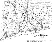
1913 trunk line system
Boston Post Road
The Boston Post Road was a system of mail-delivery routes between New York City and Boston, Massachusetts that evolved into the first major highways in the United States.The three major alignments were the Lower Post Road The Boston Post Road was a system of mail-delivery routes between New York...
. The system covered roughly 1400 miles (2,253.1 km). The 14 trunk lines were numbered on paper but were never actually signposted. The 14 trunk line routes were:
- Route 1: east-west from Greenwich to Stonington, roughly modern U.S. Route 1U.S. Route 1 in ConnecticutIn the U.S. state of Connecticut, U.S. Route 1 is a major east–west state highway along Long Island Sound. It has been replaced by Interstate 95 as a through route, which it closely parallels, and now primarily serves as a local business route...
- Route 2: north-south from Stamford to Salisbury, roughly modern Route 106Connecticut Route 106Route 106 is a state highway in southwestern Connecticut, running from Stamford to Wilton.-Route description:Route 106 begins at a junction with I-95 and US 1 in the East Side of Stamford as Courtland Avenue then turning right on Glenbrook Road...
, Route 33, Route 35, U.S. Route 7U.S. Route 7 in ConnecticutIn the state of Connecticut, U.S. Route 7 runs from Canaan to Norwalk.-Route description:U.S. 7 in Connecticut is mostly a surface road but has two short expressway sections in the Norwalk and Danbury areas. US 7 begins in Norwalk with a expressway to nearly the Wilton town line...
, Route 341, Route 41 - Route 3: north-south from Norwalk to North Canaan, roughly modern U.S. Route 7U.S. Route 7 in ConnecticutIn the state of Connecticut, U.S. Route 7 runs from Canaan to Norwalk.-Route description:U.S. 7 in Connecticut is mostly a surface road but has two short expressway sections in the Norwalk and Danbury areas. US 7 begins in Norwalk with a expressway to nearly the Wilton town line...
, Route 107Connecticut Route 107Route 107 is a state highway in southwestern Connecticut, connecting the community of Georgetown to the town center of Redding.-Route description:...
, Route 53, Route 37Connecticut Route 37Route 37 is a north–south state highway in Connecticut running for from Route 39 in Danbury, through New Fairfield, to U.S. Route 7 in New Milford...
, U.S. Route 202U.S. Route 202 in ConnecticutIn Connecticut, U.S. Route 202 is usually signed as an east–west route. It enters from the New York state line in Danbury overlapped with U.S. Route 6 and ends at the Massachusetts state line in Granby overlapped with Route 10. US 202 is overlapped with other routes for most of its...
, Route 45Connecticut Route 45Route 45 is a Connecticut state highway from US 202 in Washington to US 7 in Cornwall, in the rural northwest of the state. It is long and runs north–south.- Route description:...
, U.S. Route 7U.S. Route 7 in ConnecticutIn the state of Connecticut, U.S. Route 7 runs from Canaan to Norwalk.-Route description:U.S. 7 in Connecticut is mostly a surface road but has two short expressway sections in the Norwalk and Danbury areas. US 7 begins in Norwalk with a expressway to nearly the Wilton town line... - Route 4: north-south from Bridgeport to Colebrook, roughly modern Route 8
- Route 5: north-south from New Haven to Suffield via Cheshire (concurrent with Route 6 north of Hartford), roughly modern Route 10Connecticut Route 10Connecticut Route 10 is a state highway that runs between New Haven and the state line near Granby.-Route description:Route 10 begins at Interstate 95 as Ella T. Grasso Boulevard in the city of New Haven. It then passes by Southern Connecticut State University before entering the town of Hamden...
, Route 4, Route 159 - Route 6: north-south from New Haven to Suffield via Meriden (concurrent with Route 5 north of Hartford), roughly modern U.S. Route 5U.S. Route 5 in ConnecticutU.S. Route 5 , a north–south U.S. Highway that is generally paralleled by Interstate 91, begins at the city of New Haven in Connecticut and heads north through western Massachusetts and eastern Vermont to the international border with Canada...
, Route 71Connecticut Route 71Route 71 is a north–south state highway in Connecticut, running from Wallingford to West Hartford. It is the main north–south road of Meriden, Berlin and New Britain.-Route description:...
, Route 159 - Route 7: north-south from New Haven to Enfield via Middletown, roughly modern Route 17, Route 99Connecticut Route 99Route 99 is a state highway in Connecticut running for from Route 9 in Cromwell, through the town of Rocky Hill, ending in Wethersfield at the Hartford city line. The road continues into Hartford as a local road...
, U.S. Route 5U.S. Route 5 in ConnecticutU.S. Route 5 , a north–south U.S. Highway that is generally paralleled by Interstate 91, begins at the city of New Haven in Connecticut and heads north through western Massachusetts and eastern Vermont to the international border with Canada... - Route 8: north-south from Old Saybrook to Hartford, roughly modern Route 9, Route 99Connecticut Route 99Route 99 is a state highway in Connecticut running for from Route 9 in Cromwell, through the town of Rocky Hill, ending in Wethersfield at the Hartford city line. The road continues into Hartford as a local road...
- Route 9: north-south from New London to Colebrook, roughly modern Route 85, Route 2, Route 189Connecticut Route 189Route 189 is a state route in the U.S. states of Connecticut and Massachusetts. The route begins in the northwestern portion of the Connecticut state capital of Hartford and ends in the rural town of Granville...
, Route 20 - Route 10: north-south from New London to Thompson, roughly modern Route 32, Route 169, Route 12Connecticut Route 12Connecticut Route 12 is a state highway that runs between Groton and the state line near Thompson.-History:Route 12 was preceded by New England Interstate Route 12. The southern terminus of NE-12 was originally at New London, Connecticut. It travelled along present-day Route 32 from New London to...
, Route 193Connecticut Route 193Route 193 is a state highway in the U.S. states of Connecticut and Massachusetts. The route begins in the town centers of Thompson, Connecticut and Webster, Massachusetts. The road closely parallels Interstate 395 throughout its entire length.... - Route 11: north-south from Stonington to Woodstock, roughly modern Route 2, Route 32, U.S. Route 6U.S. Route 6 in ConnecticutU.S. Route 6 is the portion of the cross-country U.S. Route 6 within the state of Connecticut. West of Hartford, the route either closely parallels or runs along Interstate 84. Interstate 84 has largely supplanted Route 6 as a through route in western Connecticut. East of Hartford, the route serves...
, Route 198Connecticut Route 198Route 198 is a state highway in northeastern Connecticut, running from Chaplin to the Massachusetts state line in Woodstock.-Route description:... - Route 12: east-west from Salisbury to Putnam, roughly Twin Lakes Road, modern U.S. Route 44U.S. Route 44 in ConnecticutU.S. Route 44 is an east–west U.S. Highway running from Salisbury to Putnam.-Route description:From the New York state line at Salisbury to the Rhode Island state line at Putnam, US 44 runs for a total of in Connecticut. Most of US 44 is known in the state as the Jonathan Trumbull Highway...
- Route 13: east-west from KentKent, ConnecticutKent is a town in Litchfield County, Connecticut, alongside the border with New York. The population was 2,858 at the 2000 census. The town is home to three New England boarding schools: South Kent School, Kent School and The Marvelwood School. The Schaghticoke Indian Reservation is also located...
to SterlingSterling, ConnecticutSterling is a town in Windham County, Connecticut, United States. The population was 3,099 at the 2000 census.-Local History:The town was incorporated in 1794 following approval of the CT Assembly, and was carved from northern part of the Town of Voluntown...
, roughly modern Route 341, U.S. Route 202U.S. Route 202 in ConnecticutIn Connecticut, U.S. Route 202 is usually signed as an east–west route. It enters from the New York state line in Danbury overlapped with U.S. Route 6 and ends at the Massachusetts state line in Granby overlapped with Route 10. US 202 is overlapped with other routes for most of its...
, Route 118Connecticut Route 118Route 118 is a state highway in northwestern Connecticut, running from the borough of Litchfield via the village of East Litchfield to the town center of Harwinton.-Route description:...
, Route 4, U.S. Route 6U.S. Route 6 in ConnecticutU.S. Route 6 is the portion of the cross-country U.S. Route 6 within the state of Connecticut. West of Hartford, the route either closely parallels or runs along Interstate 84. Interstate 84 has largely supplanted Route 6 as a through route in western Connecticut. East of Hartford, the route serves...
, Route 14 - Route 14: east-west from ShermanSherman, ConnecticutSherman is the northernmost and least populous town of Fairfield County, Connecticut, United States. The population was 3,581 at the 2010 census. The town is named for New Haven's Founding Father, Roger Sherman....
to KillinglyKillingly, ConnecticutKillingly is a town in Windham County, Connecticut, United States. The population was 16,472 at the 2000 census. It consists of the borough of Danielson and the villages of Attawaugan, Ballouville, Dayville, East Killingly, Rogers, and South Killingly....
, roughly Route 37Connecticut Route 37Route 37 is a north–south state highway in Connecticut running for from Route 39 in Danbury, through New Fairfield, to U.S. Route 7 in New Milford...
, Route 67, Route 317Connecticut Route 317Route 317 is a state highway in west central Connecticut running from Route 67 in Roxbury to a junction with U.S. Route 6 in Woodbury. The section of Route 317 from Route 67 to Painter Hill Road in Roxbury is designated a scenic road....
, Route 64, Route 322Connecticut Route 322Route 322 is a state highway in west central Connecticut, running from Wolcott to Southington.-Route description:Route 322 begins at an intersection with Route 69 in Wolcott and curves east, southeast, and south to the southeast corner of the town, then turns east into Southington...
, Route 66, U.S. Route 6U.S. Route 6 in ConnecticutU.S. Route 6 is the portion of the cross-country U.S. Route 6 within the state of Connecticut. West of Hartford, the route either closely parallels or runs along Interstate 84. Interstate 84 has largely supplanted Route 6 as a through route in western Connecticut. East of Hartford, the route serves...
New England road marking system
The first public route numbering came with the advent of the New England road marking system of 1922. This highway numbering system was used throughout New EnglandNew England
New England is a region in the northeastern corner of the United States consisting of the six states of Maine, New Hampshire, Vermont, Massachusetts, Rhode Island, and Connecticut...
and consisted of 25 routes (with route numbers from 1 to 32). A total of 9 of the routes passed through Connecticut (Routes 1
U.S. Route 1 in Connecticut
In the U.S. state of Connecticut, U.S. Route 1 is a major east–west state highway along Long Island Sound. It has been replaced by Interstate 95 as a through route, which it closely parallels, and now primarily serves as a local business route...
, 2, 3, 4, 8
Route 8 (New England)
Route 8 is a multi-state north–south state highway in the New England region of the United States, running from Bridgeport, Connecticut, through Massachusetts to Searsburg, Vermont. Its number dates from 1922, when it was a New England Interstate Route, also known as the...
, 10
Route 10 (New England)
New England Route 10 was a multi-state north–south state highway in the New England region of the United States, running through Connecticut, Massachusetts, and New Hampshire. "Route 10" still exists as a continuous state highway in each of its original states, running from New Haven,...
, 12
Route 12 (New England)
New England Route 12 was a multi-state north–south state highway in the New England region of the United States, running from Groton, Connecticut, through Worcester, Massachusetts, and Keene, New Hampshire, to Morrisville, Vermont. Its number dates from 1922, when it was a New England...
, 17
Route 17 (New England)
Route 17 was a east–west New England Interstate Highway known as the Westerly Route. It ran from the New York-Massachusetts state line through Great Barrington, Massachusetts and Hartford, Connecticut to Westerly, Rhode Island.-Route description:The modern designations of the old...
, and 32
Route 32 (New England)
Route 32 is a multi-state north–south state highway in the New England region of the United States, running from New London, Connecticut through Massachusetts to Keene, New Hampshire. Its number dates from 1922, when it was a New England Interstate Route, also known as the Lake Sunapee Route....
). In this system, inter-state routes would be numbered 1-99 and state routes numbered 100 and up. The New England route system was soon eclipsed by the national U.S. highway system.
U.S. Highways
In 1926, the U.S. highway system was implemented. U.S. Routes 1, 5, 6, and 7 were used as designations on several primary state highways, replacing New England routes 1, 2, 3, and 4, respectively. The other New England routes that were not re-designated as U.S. routes became ordinary state highways but kept their number designation, which are used even today (with some realignment).1922-1931
The State Highway Department classified state roads as either State Highways (SH) or State Aid Roads (SA). These roads were given number designations – 100-299 for primary routes and 300+ for secondary routes. Some state roads were signposted and some were not.1932 renumbering
The state abandoned its old numbering system and renumbered almost all of their state highways in 1932. Most of the present route numbers were formed during this renumbering. The only route numbers that survived were U.S. Routes and a few state highway routes. For route numbers established in 1932, the new numbering system used odd numbers for north-south routes and even numbers for east-west routes, matching the U.S. Highway numbering system. The New England routes that were grandfathered into the highway system (Routes 8, 10, 12, 32) did not follow the new system. The state also assigned new route numbers in clusters, with routes in the same general location having numbers close to each other as well. Shortly after the renumbering, in 1935, two new U.S. Routes were commissioned: US 44 (taking over part of old New England Route 17) and US 202.Interstate highways
In 1958, Connecticut received approval for the route numbers of its three primary Interstate highways: I-84, I-91, and I-95. State highways with the same number designation as the Interstate highways were renumbered to avoid duplication of route numbers.1963 renumbering
In 1963, the state passed the Road Reclassification Act to fix the by now fragmented state highway system. Many state highways had state maintenance gaps and several highway segments were even isolated from the rest of the system. State highways were classified into primary, secondary, and service roads. Primary routes were essentially left unchanged, while minor realignments, additions/deletions, and extensions occurred in many secondary routes. About 1/3 of all routes were changed to some degree by this renumbering. The current system of unsigned ("secret") routes, including the special service roads, was also created during this renumbering. The state highway system has not had any major changes since then. The state completely abandoned the odd/even numbering scheme established in 1932 with new numbers in 1963 assigned without regard to their direction or general location.Auxiliary Interstate Highways
Connecticut's auxiliary interstate highways (I-291, I-384, I-395, I-684, I-691) were all designated after the 1963 renumbering.See also
- List of crossings of the Connecticut River
- New England Interstate Routes
- Connecticut TurnpikeConnecticut TurnpikeThe Connecticut Turnpike, known now as the Governor John Davis Lodge Turnpike, is a freeway in Connecticut that runs from Greenwich to Killingly. It is signed as Interstate 95 from the New York state line at Greenwich to East Lyme, and then as Interstate 395 from East Lyme to Plainfield...
- Berlin TurnpikeBerlin TurnpikeThe Berlin Turnpike is a 4-lane/6-lane divided arterial road carrying U.S. Route 5 and Route 15 through the towns of Berlin, Newington, and Wethersfield, Connecticut, United States. The road begins at the Meriden-Berlin town line. The official length of the Berlin Turnpike is 11.02 miles but the...
- Merritt ParkwayMerritt ParkwayThe Merritt Parkway is a historic limited-access parkway in Fairfield County, Connecticut. The parkway is known for its scenic layout, its uniquely styled signage, and the architecturally elaborate overpasses along the route. It is designated as a National Scenic Byway and is also listed in the...
- Oak Street ConnectorOak Street ConnectorThe Oak Street Connector, officially known as the Richard C. Lee Highway, is a long freeway section of Route 34 that is located in downtown New Haven, Connecticut...
- Wilbur Cross ParkwayWilbur Cross ParkwayThe Wilbur Cross Parkway is a limited access road in Connecticut, comprising the portion of Route 15 between Milford and Meriden. It is named after Wilbur Lucius Cross, a former governor of the state...
- Wilbur Cross HighwayWilbur Cross HighwayThe Wilbur Cross Highway is the designation for the portion of old Route 15 from Wethersfield in Connecticut, through Hartford and Manchester, to the Massachusetts Turnpike in Sturbridge, Massachusetts. The highway was built in the 1940s before the Interstate Highway era...
- Bradley Airport ConnectorBradley Airport ConnectorThe Bradley Airport Connector is a expressway built to connect Bradley International Airport to Interstate 91 in Windsor, Connecticut. It begins at Exit 40 of I-91 and heads west as Route 20 roughly along the town line between Windsor and Windsor Locks...
- Whitehead Highway