

List of Special Places of Scenic Beauty, Special Historic Sites and Special Natural Monuments
Encyclopedia
To protect Japan's cultural heritage, the country's government selects through the Agency for Cultural Affairs
important items and designates them as Cultural Properties
under the Law for the Protection of Cultural Properties. Designated items are classified in a number of categories one of which is . This category includes historic locations such as shell mounds
, ancient tombs, sites of palaces, sites of forts or castles, monumental dwelling houses and other sites of high historical or scientific value; gardens, bridges, gorges, mountains, and other places of great scenic beauty; and natural features such as animals, plants, and geological or mineral formations of high scientific value.
The government further designates "significant" monuments classifying them in three categories: , , and . Items of particularly high significance receive higher classifications: , , and respectively. As of April 2010 there are 980 Natural Monuments, 1661 Historic Sites, 357 Places of Scenic Beauty, 75 Special Natural Monuments, 61 Special Historic Sites and 36 Special Places of Scenic Beauty. Since a single item can fall under more than one of these categories, the total number of sites is less than the sum of designations.
}
| 8, 11
|
|
| One of the Three Views of Japan
|Shiogama
, Shichigahama
, Rifu
, Matsushima
, Higashimatsushima
, Miyagi
38°21′59.13"N 141°4′27.87"E
| |-
|-
|
| 1
| 2,8
|
|
|Tokyo
35°39′35.3"N 139°45′46.5"E
| |-
|-
|
| 1
| 8
|
|
|Tokyo
35°42′19.63"N 139°44′57.37"E
|
|-
|
| 1
|
|
|
|Tokyo
35°43′58.66"N 139°44′47.48"E
|
|-
|
| 6
|
| 4
|
|Tateyama
, Unazuki
, Toyama
36°37′23.18"N 137°41′11.4"E
|
|-
|
| 1
|
|
| One of the Three Great Gardens of Japan
|Kanazawa
, Ishikawa
36°33′43.5"N 136°39′44.99"E
|
|-
|
| 1
|
|
| The ruins at the same site are a Special Historic Site.
|Fukui
, Fukui
35°59′57.95"N 136°17′43.52"E
|
|-
|
| 5, 6
|
|
|
|Kōfu
and Kai
, Yamanashi
35°44′41.64"N 138°33′59.29"E
|
|-
|
| 6
|
| 4
|
|Matsumoto
, Nagano
36°14′24.93"N 137°37′27.07"E
| |-
|-
|
| 1
|
|
|
|Kyoto, Kyoto
35°0′38.29"N 135°47′24.02"E
|
|-
|
| 1
| 8
|
|
|Kyoto, Kyoto
35°1′35.78"N 135°47′54.31"E
|
|-
|
| 1
| 8
|
|
|Kyoto, Kyoto
35°2′21.38"N 135°43′43.33"E
|
|-
|
| 1
|
|
| Also a historic site (hist-crit.: 8)
|Kizugawa
, Kyoto
34°42′56.16"N 135°52′22.8"E
|
|-
|
| 1
|
|
| Also a historic site (hist-crit.: 8)
|Kyoto, Kyoto
34°59′32.5"N 135°41′3.81"E
| |-
|-
|
| 1
|
|
| Also a historic site (hist-crit.: 8)
|Kyoto, Kyoto
35°2′40.66"N 135°44′45.01"E
|
|-
|
| 1
|
|
| Also a historic site (hist-crit.: 8)
|Kyoto, Kyoto
35°2′40.66"N 135°44′45.01"E
|
|-
|
| 1
| 8
|
|
|Kyoto, Kyoto
34°57′6.78"N 135°49′10.2"E
|
|-
|
| 3, 8, 11
|
|
| One of the Three Views of Japan
|Miyazu
, Kyoto
35°34′12.02"N 135°11′30.59"E
|
|-
|
| 1
|
|
| Also a historic site (hist-crit.: 8)
|Kyoto, Kyoto
35°0′56.68"N 135°40′23.53"E
|
|-
|
| 1
|
|
|
|Kyoto, Kyoto
35°0′48.27"N 135°44′57.22"E
|
|-
|
| 1, 10
|
|
|
|Kyoto, Kyoto
35°1′11.77"N 135°42′59.03"E
|
|-
|
| 1
|
|
| Also a historic site (hist-crit: 8)
|Kyoto, Kyoto
34°59′27.37"N 135°45′4.47"E
|
|-
|
| 1
|
|
| Also a historic site (hist-crit: 8)
|Kyoto, Kyoto
35°2′3.81"N 135°43′5.42"E
|
|-
|
| 1
|
|
| Reconstruction of an 8th century Imperial Palace Garden with ponds and pebble shore
|Nara
, Nara
34°41′28"N 135°47′44"E
|
|-
|
| 1
| 2, 8
|
| The ruins at the same site are a Special Historic Site.
|Nara
, Nara
34°41′1.45"N 135°48′8.44"E
|
|-
|
| 1
|
|
| One of the Three Great Gardens of Japan
|Okayama
, Okayama
34°40′3.94"N 133°56′7.78"E
|
|-
|
| 8
| 2,3
|
| Includes one of the Three Views of Japan
|Hatsukaichi
, Hiroshima
34°17′1.99"N 132°19′5.9"E
| |-
|-
|
| 3,5,6
|
|
|
|Akiōta
, Hiroshima
34°37′28.85"N 132°11′8.97"E
|
|-
|
| 1
|
|
|
|Takamatsu
, Kagawa
34°19′39.2"N 134°2′35.76"E
|
|-
|
| 3,9
|
|
|
|Karatsu
, Saga
33°26′35.99"N 130°0′34.37"E
|
|-
|
| 1, 3, 9, 10
|
|
|
|Shimabara
, Nagasaki
32°45′37.54"N 130°17′31.25"E
|
|-
|
| 1
|
|
|
|Naha
, Okinawa
26°12′14.1"N 127°42′55.32"E
|
|-
|
| 6, 7
|
|
| Also a Natural Monument (4)
|Towadako
, Aomori
and Kosaka
, Akita
40°28′23.05"N 140°52′39.67"E
|
|-
|
| 5,6
|
|
| Also a Natural Monument (3.1)
|Kumanogawa
, Wakayama
, Kiwa
, Mie
and Totsukawa
, Nara
33°52′23.24"N 135°51′27.43"E
|
|-
|
| 10
|
|
|
|Yamanashi
, Shizuoka
35°21′28.8"N 138°43′51.6"E
| |-
|-
|
|
| 2
|
| Star fort
of the Republic of Ezo
|Hakodate
, Hokkaidō
41°47′49.8"N 140°45′24.3"E
| |-
|-
|
|
| 1
|
| Jōmon period
archaeological site
|Aomori
, Aomori
40°48′40.24"N 140°41′44.3"E
|
|-
|
|
| 3
|
|
|Hiraizumi
, Iwate
39°0′6.68"N 141°6′0.46"E
|
|-
|
|
| 3
|
|
|Hiraizumi
, Iwate
38°59′36.08"N 141°6′56.81"E
|
|-
|
|
| 3
|
|
|Hiraizumi
, Iwate
38°59′13.89"N 141°6′27.26"E
|
|-
|
|
| 2, 3
|
|
|Tagajō
, Miyagi
38°17′57.54"N 140°59′52.41"E
|
|-
|
|
| 1
|
|
|Kazuno
, Akita
40°16′16.96"N 140°48′15.06"E
|
|-
|
|
| 4
|
| Former school of the Mito Clan, founded in 1841 by Tokugawa Nariaki
|Mito
, Ibaraki
36°22′31.54"N 140°28′38.27"E
|
|-
|
|
| 3
|
|
|Ishioka
, Ibaraki
36°11′48.17"N 140°16′25.38"E
|
|-
|
|
| 3
|
|
|Ishioka
, Ibaraki
36°12′6.18"N 140°16′3.25"E
|
|-
|
|
| 3
|
| Stone reliefs of Buddhist deities in a cave
|Utsunomiya
, Tochigi
36°35′46.35"N 139°49′16.94"E
|
|-
|
|
| 6
| 2.1
| Three roads totalling 37 km (23 mi)
|Nikkō
, Imaichi
and Kanuma
, Tochigi
36°35′46.35"N 139°49′16.94"E
| |-
|-
|
|
| 3, 7
|
| 110 cm (43.3 in) high stone stele from 726
|Takasaki
, Gunma
36°17′8.37"N 139°0′58.21"E
|
|-
|
|
| 1, 7
|
|
|Takasaki
, Gunma
36°16′37.48"N 139°1′40.09"E
|
|-
|
|
| 2, 7
|
|
|Takasaki
, Gunma
36°15′54.1"N 138°59′46.67"E
|
|-
|
|
| 2
|
|
|Tokyo
35°41′8.93"N 139°45′23.95"E
| |-
|-
|
|
| 2, 3, 6, 7, 8
|
| The gardens at the same site are a Special Place of Scenic Beauty.
|Fukui
, Fukui
35°59′57.95"N 136°17′43.52"E
|
|-
|
|
| 1
|
| Jōmon period
archaeological site
|Chino
, Nagano
36°0′46.32"N 138°13′55.04"E
|
|-
|
|
| 3
|
|
|Iwata
, Shizuoka
34°43′10.45"N 137°51′5.75"E
|
|-
|
|
| 6
|
| Set up by Tokugawa Ieyasu
|Arai
, Shizuoka
34°41′40.99"N 137°33′40.82"E
|
|-
|
|
| 1
|
| Late Yayoi
archaeological site
|Shizuoka
, Shizuoka
34°57′22.26"N 138°24′29.74"E
| |-
|-
|
|
| 2
|
|
|Nagoya
, Aichi
35°11′5.8"N 136°53′58.77"E
|
|-
|
|
| 8
|
|
|Matsusaka
, Mie
34°34′30.9"N 136°31′32.94"E
| |-
|-
|
|
| 2
|
|
|Azuchi
and Higashiōmi
, Shiga
35°9′21.25"N 136°8′21.79"E
|
|-
|
|
| 2
|
|
|Hikone
, Shiga
35°16′35.87"N 136°15′9.02"E
|
|-
|
|
| 2
|
|
|Osaka, Osaka
34°41′14.3"N 135°31′35.04"E
|
|-
|
|
| 3
|
|
|Hirakata
, Osaka
34°48′55.29"N 135°39′39.15"E
|
|-
|
|
| 2
|
|
|Himeji
, Hyōgo
34°50′18.85"N 134°41′34.97"E
| |-
|-
|
|
| 1
|
|
|Asuka
, Nara
34°27′5.25"N 135°48′18.49"E
|
|-
|
|
| 1
|
|
|Asuka
, Nara
34°27′43.94"N 135°48′23.2"E
|
|-
|
|
| 3
|
|
|Sakurai
, Nara
34°29′4.02"N 135°49′48.09"E
|
|-
|
|
| 1
|
|
|Asuka
, Nara
34°28′0.15"N 135°49′33.88"E
|
|-
|
|
| 1
|
|
|Kōryō
, Nara
34°33′23.06"N 135°44′27.63"E
|
|-
|
|
| 2
|
| Palace of the Fujiwara capital
|Kashihara
, Nara
34°30′8.71"N 135°48′26.44"E
|
|-
|
|
| 1
|
|
|Sakurai
, Nara
34°30′13.55"N 135°50′33.21"E
|
|-
|
|
| 2
|
| Palace of the Heijō capital
; the gardens at the same site are a Special Place of Scenic Beauty
|Nara
, Nara
34°41′28.46"N 135°47′42.02"E
|
|-
|
|
| 3
|
| Yakushi-ji
of the Fujiwara capital
|Kashihara
, Nara
34°29′33.88"N 135°48′0.95"E
|
|-
|
|
| 1
|
|
|Wakayama
, Wakayama
34°13′33.08"N 135°13′38.9"E
|
|-
|
|
| 3
|
|
|Tōhaku
, Tottori
35°28′53.65"N 133°42′41.13"E
|
|-
|
|
| 4
|
|
|Bizen
, Okayama
34°47′46.77"N 134°13′10.23"E
|
|-
|
|
| 4, 8
|
| Chazan Kan (1748–1827) was a Confucian scholar.
|Fukuyama
, Hiroshima
34°32′41.26"N 133°23′4.1"E
|
|-
|
|
| 3
|
| Temple 80 of the Shikoku pilgrimage
|Takamatsu
, Kagawa
34°18′13.18"N 133°56′39.65"E
|
|-
|
|
| 1
|
|
|Keisen
, Fukuoka
33°35′19.47"N 130°39′49.84"E
|
|-
|
|
| 2
|
| Low embankment built in 664 by the Dazaifu (大宰府), the imperial office governing Kyūshū, against an invasion from Tang Dynasty
China and Korea
|Dazaifu
, Kasuga
and Ōnojō
, Fukuoka
33°31′2.41"N 130°29′28.42"E
|
|-
|
|
| 2
|
| Ruins of the governmental office with jurisdiction over Kyūshū
|Dazaifu
, Fukuoka
33°30′52.43"N 130°30′54.55"E
|
|-
|
|
| 2, 3
|
| Asuka period
castle
|Dazaifu
, Umi
and Ōnojō
, Fukuoka
33°31′16.9"N 130°30′54.01"E
|
|-
|
|
| 1
|
| Yayoi period
archaeological site
|Yoshinogari
, Saga
33°19′25.18"N 130°23′6.43"E
| |-
|-
|
|
| 2
|
|
|Chinzei
, Yobuko
and Genkai
, Saga
33°31′48.65"N 129°52′9.75"E
|
|-
|
|
| 2
|
| Asuka period
mountain castle
|Tsushima
, Nagasaki
34°16′6.07"N 129°18′49.69"E
|
|-
|
|
| 1
|
|
|Iki
, Nagasaki
33°45′48.68"N 129°44′55.04"E
|
|-
|
|
| 2
|
|
|Kumamoto
, Kumamoto
32°48′20.55"N 130°42′21.21"E
|
|-
|
|
| 3
|
|
|Usuki
, Ōita
33°5′26.18"N 131°45′47.04"E
|
|-
|
|
| 1
|
|
|Saito
, Miyazaki
32°7′14.95"N 131°23′17.84"E
|
|-
|
|
| 2
|
|
|Chikushino
, Fukuoka
and Kiyama
, Saga
33°26′39.34"N 130°30′36.09"E
|
|-
|
|
|
| 2.3
|
|Samani
, Hokkaidō
42°6′25.35"N 143°1′41.89"E
|
|-
|
|
|
| 2.12, 2.8
|
|Akan
, Hokkaidō
43°27′1.54"N 144°5′57.93"E
| |-
|-
|
|
|
| 3.10
|
|Sōbetsu
, Hokkaidō
42°32′37.17"N 140°51′51.77"E
|
|-
|
|
|
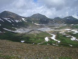
| 4
|
|Kamikawa
, Higashikawa
, Biei
and Shintoku
, Hokkaidō
43°40′58.87"N 142°53′55.78"E
| |-
|-
|
|
|
| 2.2
|
|Kitahiroshima
, Hokkaidō
43°3′12.46"N 141°30′3.09"E
|
|-
|
|
|
| 1.2
| Whooper Swan
s
|Hiranai
, Aomori
40°56′14.09"N 140°58′23.88"E
|
|-
|
|
|
| 3.8
|
|Kitakami
, Iwate
39°12′36.64"N 140°52′55.74"E
|
|-
|
|
|
| 3.1
| 15–20 Million years old
|Ichinohe
, Iwate
40°11′24.78"N 141°20′4.42"E
|
|-
|
|
|
| 3.5, 3.10
|
|Nishine
, Iwate
39°52′30.82"N 141°2′51.16"E
|
|-
|
|
|
| 2.3
|
|Hanamaki
, Tōno
and Kawai
, Iwate
39°31′53.71"N 141°28′26.53"E
|
|-
|
|
|
| 3.8
|
|Ōsaki
, Miyagi
38°48′0.19"N 140°38′52.81"E
|
|-
|
|
|
| 3.1, 3.8
| Hokutolite is a type of radioactive baryte.
|Semboku, Akita
39°57′42.57"N 140°43′42.18"E
|
|-
|
|
|
| 2.1
|
|Tsuruoka
, Yamagata
38°42′13.91"N 139°58′13.33"E
| |-
|-
|
|
|
| 2.1
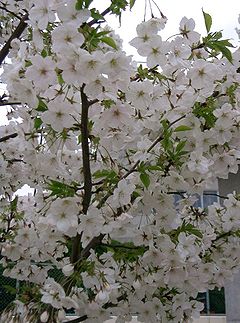
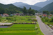
| More than 1000 year old, and perimeter larger than , largest zelkova tree in Japan
|Higashine
, Yamagata
38°26′31.16"N 140°24′6.28"E
|
|-
|
|
|
| 2.12
| A species of butterwort
endemic to Nikkō National Park
|Nikkō
, Tochigi
36°40′27.13"N 139°21′42.9"E
| |-
|-
|
|
|
| 3.2, 3.7, 3.10
|
|Tsumagoi
, Gunma
36°26′53.57"N 138°30′56.25"E
|
|-
|
|
|
| 2.1
|
|Kasukabe
, Saitama
35°59′5.83"N 139°46′24.07"E
|
|-
|
|
|
| 3.1, 3.5
|
|Kamikawa
, Saitama
36°10′45.91"N 139°4′14.18"E
|
|-
|
|
|
| 2.4
|
|Saitama
, Saitama
35°50′17.41"N 139°36′56.66"E
|
|-
|
|
|
| 1.3
|
|Kamogawa
, Chiba
35°7′5.98"N 140°11′28.67"E
|
|-
|
|
|
| 2.1
| Single tree, 7.9 m (25.9 ft) circumference; species is native to Ōshima
and Izu Peninsula
|Ōshima
, Tokyo
34°45′49.01"N 139°26′3.07"E
|
|-
|
|
|
| 1.3
|
|Toyama
and Uozu
, Toyama
36°46′36.01"N 137°20′40.69"E
|
|-
|
|
|
| 3.1, 3.5
| Tree trunks of a cedar
forest partially buried about 2000 years ago; largest has a circumference of ca. 12 m (39.4 ft)
|Shakadō, Uozu
, Toyama
36°49′31.5"N 137°24′23.53"E
|
|-
|
|
|
| 3.11
|
|Toyama
, Toyama
36°28′5.64"N 137°32′38.48"E
|
|-
|
|
|
| 3.8
|
|Hakusan
, Ishikawa
36°13′39.32"N 136°46′11.69"E
|
|-
|
|
|
| 3.6, 3.10
|
|Narusawa
, Yamanashi
35°25′34.06"N 138°42′3.05"E
|
|-
|
|
|
| 3.8
|
|Matsumoto
, Nagano
36°8′51.72"N 137°37′28.85"E
|
|-
|
|
|
| 3.5
|
|Motosu
, Gifu
35°37′1.62"N 136°37′14.98"E
|
|-
|
|
|
| 2.1
| Circumference 14 m (45.9 ft)
|Gujō
, Gifu
36°0′5.83"N 136°46′18.49"E
|
|-
|
|
|
| 2.1
| Oldest tree of the mountain sakura, crown 21.81 m (71.6 ft) (EW) and 16.33 m (53.6 ft) (NS)
|Fujinomiya
, Shizuoka
35°18′6.92"N 138°35′19.59"E
|
|-
|
|
|
| 3.10
|
|Fujinomiya
, Shizuoka
35°13′38.07"N 138°36′41.14"E
|
|-
|
|
|
| 1.2
|
|Maibara
, Shiga
35°21′22.54"N 136°22′4.84"E
|
|-
|
|
|
| 2.2
| Part of the World Heritage Site
"Historic Monuments of Ancient Nara
"
|Nara
, Nara
34°40′56.19"N 135°51′46.13"E
|
|-
|
|
|
| 2.2
|
|Daisen
, Tottori
35°29′0.95"N 133°30′28.51"E
|
|-
|
|
|
| 3.6, 3.10
|
|Matsue
, Shimane
35°29′42.59"N 133°10′34.42"E
|
|-
|
|
|
| 3.1, 3.3, 3.6, 3.9
| Karst topography
|Mine
, Yamaguchi
34°14′11.14"N 131°17′26.05"E
| |-
|-
|
|
|
| 3.6, 3.9
| At 8.7 km (5.4 mi) second longest cave in Japan
|Mine
, Yamaguchi
34°13′40.17"N 131°18′12.32"E
|
|-
|
|
|
| 1.2
| Hooded Crane
s
|Shūnan
and Kudamatsu
, Yamaguchi
34°5′56.19"N 131°56′49.83"E
|
|-
|
|
|
| 2.1
|
|Higashimiyoshi
, Tokushima
34°2′27.39"N 133°55′54.92"E
|
|-
|
|
|
| 2.1
| 23 m (75.5 ft) high, 15 m (49.2 ft) circumference at ground level
|Tonoshō
, Kagawa
34°29′36.11"N 134°11′49.86"E
|
|-
|
|
|
| 3.9
|
|Kumakōgen
, Ehime
33°42′13.6"N 132°57′38.39"E
|
|-
|
|
|
| 1.2
|
|Kōchi
, Kōchi
33°33′13.06"N 133°32′24.07"E
|
|-
|
|
|
| 2.1
| Two stems, each about 16 m (52.5 ft) circumference
|Ōtoyo
, Kōchi
33°45′20.17"N 133°39′47.01"E
|
|-
|
|
|
| 2.1
|
|Asakura
and Kama
, Fukuoka
33°28′54.67"N 130°43′29.8"E
|
|-
|
|
|
| 2.2, 2.10
|
|Shingū
and Hisayama
, Fukuoka
33°40′45.67"N 130°28′6.23"E
|
|-
|
|
|
| 2.1, 2.12
|
|Kikuka
, Kumamoto
33°3′51.16"N 130°46′5.53"E
|
|-
|
|
|
| 2.2
|
|Aoshima
, Miyazaki
, Miyazaki
31°48′18.69"N 131°28′32.7"E
|
|-
|
|
|
| 2.10
|
|Kushima
, Miyazaki
31°21′54.78"N 131°20′24.03"E
|
|-
|
|
|
| 2.12
| Mitrastema yamamotoi
|Miyazaki
, Miyazaki
31°44′28.97"N 131°28′3.81"E
|
|-
|
|
|
| 2.2
| Includes with the Jōmon Sugi
, the oldest specimen of Cryptomeria japonica
|Yakushima
, Kagoshima
30°19′40.23"N 130°31′23.06"E
|
|-
|
|
|
| 2.1
| Height: 30 m (98.4 ft), circumference: 24 m (78.7 ft)
|Kamō, Kagoshima
31°45′44.38"N 130°34′11.77"E
|
|-
|
|
|
| 2.10
|
|Kagoshima
, Kagoshima
31°22′29.34"N 130°32′49.26"E
|
|-
|
|
|
| 2.10
|
|Yamagawa
, Bonotsu
, Sata
and Uchinoura
, Kagoshima
31°21′13.09"N 130°42′15.64"E
|
|-
|
|
|
| 1.2
| Hooded Crane
s
|Izumi
, Kagoshima
32°6′9.52"N 130°16′25.75"E
|
|-
|
|
|
| 2.2, 2.10
|
|Shibushi
, Kagoshima
31°25′45.3"N 131°7′1.89"E
|
|-
|
|
|
| 2.3
|
|Asahi
and Kurobe
in Toyama
; Hakuba
in Nagano
; Itoigawa
in Niigata
36°38′56.9"N 137°44′55.73"E
|
|-
|
|
|
| 4
|
|Yunotani
, Niigata
; Katashina
, Gunma
; Hinoemata
, Fukushima
36°56′33.93"N 139°13′59.41"E
| |-
|-
|
|
|
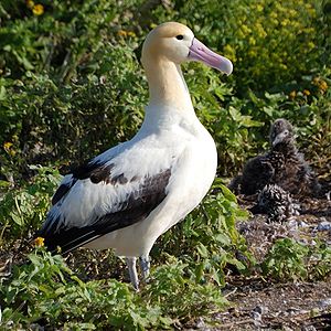
| 1.2
|
|Tokyo and Okinawa
| |-
|-
|
|
|
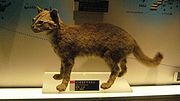
| 1.1
|
|Tokunoshima
and Amami Ōshima
, Kagoshima
|
|-
|
|
|
| 1.1
| Endemic to one island (Iriomote
)
|Iriomote
, Okinawa
| |-
|-
|
|
|
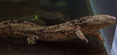
| 1.2
| At up to 1.5 m (4.9 ft) length, the second largest salamander in the world
|11 prefectures, among others: Gifu
, Mie
, Hyōgo
, Hiroshima
, Shimane
, Tottori
, Ōita
| |-
|-
|
|
|
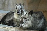
| 1.1
| found on all main Japanese islands except for Hokkaidō
|29 prefectures including Aomori
| |-
|-
|
|
|
| 1.2
|
|various
|
|-
|
|
|
| 1.1
|
|Okinawa
|
|-
|
|
|
| 1.2
|
|Hyōgo
and Fukui
|
|-
|
|
|
| 1.2
|
|Hokkaidō
|
|-
|
|
|
| 1.2
|
|Niigata
and Ishikawa
| |-
|-
|
|
|
| 1.1
| Endemic to Okinawa Island
|Okinawa Island
, Okinawa
|
|-
|
|
|
| 1.1
| Endemic to the Bonin Islands
|Bonin Islands, Tokyo
|
|-
|
|
|
| 1.2
|
|Toyama
, Nagano
, Niigata
, Yamanashi
, Shizuoka
, Gifu
| |-
|-
|
|
|
| 1.4
|
|Nankoku
, Kōchi
|
|}
Agency for Cultural Affairs
The is a special body of the Japanese Ministry of Education . It was set up in 1968 to promote Japanese arts and culture. As of April 2007, it is led by the Commissioner for Cultural Affairs, Tamotsu Aoki....
important items and designates them as Cultural Properties
Cultural Properties of Japan
As defined by the Japanese government's Agency for Cultural Affairs, the are tangible properties and intangible properties created or developed in JapanDespite the official definition, some Cultural Properties of Japan were created in China, Korea or other...
under the Law for the Protection of Cultural Properties. Designated items are classified in a number of categories one of which is . This category includes historic locations such as shell mounds
Midden
A midden, is an old dump for domestic waste which may consist of animal bone, human excrement, botanical material, vermin, shells, sherds, lithics , and other artifacts and ecofacts associated with past human occupation...
, ancient tombs, sites of palaces, sites of forts or castles, monumental dwelling houses and other sites of high historical or scientific value; gardens, bridges, gorges, mountains, and other places of great scenic beauty; and natural features such as animals, plants, and geological or mineral formations of high scientific value.
The government further designates "significant" monuments classifying them in three categories: , , and . Items of particularly high significance receive higher classifications: , , and respectively. As of April 2010 there are 980 Natural Monuments, 1661 Historic Sites, 357 Places of Scenic Beauty, 75 Special Natural Monuments, 61 Special Historic Sites and 36 Special Places of Scenic Beauty. Since a single item can fall under more than one of these categories, the total number of sites is less than the sum of designations.
Criteria
The Agency for Cultural Affairs designates monuments based on a number of criteria. A monument can be designated based on more than one of these criteria:Places of Scenic Beauty and Special Places of Scenic Beauty
- Parks and gardens (公園、庭園)
- Bridges and embankments (橋梁、築堤)
- Flowering trees, flowering grass, autumn colors, green trees and other places of dense growth (花樹、花草、紅葉、緑樹などの叢生する場所)
- Places inhabited by birds and wild animals, fish/insects and others (鳥獣、魚虫などの棲息する場所)
- Rocks, caves (岩石、洞穴)
- Ravines, gorges, waterfalls, mountain streams, abysses (峡谷、瀑布、溪流、深淵)
- Lakes, marshes, wetlands, floating islands, springs (湖沼、湿原、浮島、湧泉)
- Sand dunes, spitsSpit (landform)A spit or sandspit is a deposition landform found off coasts. At one end, spits connect to land, and extend into the sea. A spit is a type of bar or beach that develops where a re-entrant occurs, such as at cove's headlands, by the process of longshore drift...
, seasides, islands (砂丘、砂嘴、海浜、島嶼) - Volcanoes, onsen (火山、温泉)
- Mountains, hills, plateaus, plains, rivers (山岳、丘陵、高原、平原、河川)
- Viewpoints (展望地点)
Historic Sites and Special Historic Sites
- Shell mounds, settlement ruins, kofunKofunKofun are megalithic tombs or tumuli in Japan, constructed between the early 3rd century and early 7th century. They gave their name to the Kofun period . Many of the Kofun have a distinctive keyhole-shaped mound , unique to ancient Japan...
, other historic ruins of this type (貝塚、集落跡、古墳その他この類の遺跡) - Ruins of fortified towns, castles, government administration offices, old battlefields and other historic ruins related to politics or government (都城跡、国郡庁跡、城跡、官公庁、戦跡その他政治に関する遺跡)
- Remains of shrines and temples, former compound grounds and other historic ruins related to religion (社寺の跡又は旧境内その他祭祀信仰に関する遺跡)
- Schools, research institutions, cultural facilities and other historic ruins related to education, learning or culture (学校、研究施設、文化施設その他教育・学術・文化に関する遺跡)
- Medical care and welfare facilities, life related institution, other society and life related historic ruins (医療・福祉施設、生活関連施設その他社会・生活に関する遺跡)
- Transport and communication facilities, forest conservation and flood control facilities, manufacture facilities and other historic sites related to finance or manufacture activities (交通・通信施設、治山・治水施設、生産施設その他経済・生産活動に関する遺跡)
- Graves and stone monuments with inscriptions (墳墓及び碑)
- Former residences, gardens, ponds and other areas of particular historical significance (旧宅、園池その他特に由緒のある地域の類)
- Ruins related to foreign countries or foreigners (外国及び外国人に関する遺跡)
Natural Monuments and Special Natural Monuments
- Animals (動物)
- Well-known animals peculiar to Japan and their habitat (日本特有の動物で著名なもの及びその棲息地)
- Animals which are not peculiar to Japan, but need to be preserved as well-known characteristic Japanese animals, and their habitat (特有の産ではないが、日本著名の動物としてその保存を必要とするもの及びその棲息地)
- Animals or animal groups peculiar to Japan within their natural environment (自然環境における特有の動物又は動物群聚)
- Domestic animals peculiar to Japan (日本に特有な畜養動物)
- Well-known imported animals presently in a wild state, with the exception of domestic animals; their habitat (家畜以外の動物で海外よりわが国に移殖され現時野生の状態にある著名なもの及びその棲息地)
- Particularly valuable animal specimen (特に貴重な動物の標本)
- Plants, vegetation (植物)
- Old trees of historic interest, gigantic trees, old trees, deformed trees, cultivated pulpwood, roadside trees, shrine forests (名木、巨樹、老樹、畸形木、栽培植物の原木、並木、社叢)
- Representative primeval forests, rare forest flora (代表的原始林、稀有の森林植物相)
- Representative alpine plants, special clusters of plants on rock ground (代表的高山植物帯、特殊岩石地植物群落)
- Representative clusters of waste land plants (代表的な原野植物群落)
- Representative examples of coastal and sand ground vegetation (海岸及び沙地植物群落の代表的なもの)
- Representative examples of areas of peat forming plants (泥炭形成植物の発生する地域の代表的なもの)
- Clusters of plants growing in caves or grottoes (洞穴に自生する植物群落)
- Rare water plants in garden ponds, onsen, lakes, marshes, streams, sea, etc.; algae, moss, microbes, etc. (池泉、温泉、湖沼、河、海等の珍奇な水草類、藻類、蘚苔類、微生物等の生ずる地域)
- Remarkable occurrence of epiphyticEpiphyteAn epiphyte is a plant that grows upon another plant non-parasitically or sometimes upon some other object , derives its moisture and nutrients from the air and rain and sometimes from debris accumulating around it, and is found in the temperate zone and in the...
plants on rocks, trees or shrubs (着生草木の著しく発生する岩石又は樹木) - Remarkable plant growth on marginal land (著しい植物分布の限界地)
- Remarkable growth in the wild of crop plants (著しい栽培植物の自生地)
- Wild habitat of rare or near extinct plants (珍奇又は絶滅に瀕した植物の自生地)
- Geological and mineralogical features (地質鉱物)
- Rocks, mineral and fossil producing sites (岩石、鉱物及び化石の産出状態)
- Conformable and unconformable strataStratumIn geology and related fields, a stratum is a layer of sedimentary rock or soil with internally consistent characteristics that distinguish it from other layers...
(地層の整合及び不整合) - Fold and thrust strataStratumIn geology and related fields, a stratum is a layer of sedimentary rock or soil with internally consistent characteristics that distinguish it from other layers...
(地層の褶曲及び衝上) - Geological features caused by the work of living creatures (生物の働きによる地質現象)
- Phenomena related to earthquake dislocation and landmass motion (地震断層など地塊運動に関する現象)
- Caves, grottoes (洞穴)
- Examples of rock organization (岩石の組織)
- Onsen and their sediments (温泉並びにその沈澱物)
- Erosion and weathering related phenomena (風化及び侵蝕に関する現象)
- FumaroleFumaroleA fumarole is an opening in a planet's crust, often in the neighborhood of volcanoes, which emits steam and gases such as carbon dioxide, sulfur dioxide, hydrochloric acid, and hydrogen sulfide. The steam is created when superheated water turns to steam as its pressure drops when it emerges from...
s and other items related to volcanic activity (硫気孔及び火山活動によるもの) - Ice and frost related phenomena (氷雪霜の営力による現象)
- Particularly precious rock, mineral and fossil specimen (特に貴重な岩石、鉱物及び化石の標本)
- Representative territories rich in natural monuments to be protected (Natural Protected Areas) (保護すべき天然記念物に富んだ代表的一定の区域(天然保護区域))
Usage
The table's columns (except for Remarks and Photo) are sortable pressing the arrows symbols. The following gives an overview of what is included in the table and how the sorting works.- Name: name of the monument as registered in the Database of Cultural Properties
- Special Place of Scenic Beauty: criteria under which the monument has been designated or "-" if it is not a Special Place of Scenic Beauty
- Special Historic Site: criteria under which the monument has been designated or "-" if it is not a Special Historic Site
- Special Natural Monument: criteria under which the monument has been designated or "-" if it is not a Special Natural Monument
- Remarks: general remarks
- Location: "town-name prefecture-name" and geo coordinates of the monument if applicable
-
-
- sorts as "prefecture-name town-name"
- Photo: picture of the monument
- sorts as "prefecture-name town-name"
-
Special Places of Scenic Beauty, Special Historic Sites, Special Natural Monuments
| Name | Special Place of Scenic Beauty | Special Historic Site | Special Natural Monument | Remarks | Location | Photo |
|---|---|---|---|---|---|---|
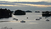
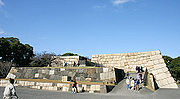
| 1 | Hiraizumi Hiraizumi, Iwate is a town located in Nishiiwai District, Iwate, Japan. It was the home of the Hiraizumi Fujiwaras for about 100 years in the late Heian era and most of the following Kamakura period. At the same time it served as the de facto capital of Oshu, an area containing nearly a third of the Japanese land... , Iwate Iwate Prefecture is the second largest prefecture of Japan after Hokkaido. It is located in the Tōhoku region of Honshū island and contains the island's easternmost point. The capital is Morioka. Iwate has the lowest population density of any prefecture outside Hokkaido... 38°59′16.31"N 141°6′28.98"E |
 |
||||
| 8, 11
|
|
| One of the Three Views of Japan
Three Views of Japan
The is the canonical list of Japan's three most celebrated scenic sights, attributed to 1643 and scholar Hayashi Gahō. The views are of the eponymous pine-clad islands of Matsushima in Miyagi Prefecture; the pine-clad sandbar of Amanohashidate in Kyoto Prefecture; and Itsukushima Shrine in...
|Shiogama
Shiogama, Miyagi
is a city located in Miyagi Prefecture, Japan.As of 2005, the city has an estimated population of 59,429 and a population density of 3,329 persons per km², making it the most densely populated conurbation in Tōhoku...
, Shichigahama
Shichigahama, Miyagi
is a town located in Miyagi District, Miyagi, Japan.As of January 1, 2011, the town has an estimated population of 20,396. The total area is 13.27 km².-Geography:...
, Rifu
Rifu, Miyagi
is a town located in Miyagi District, Miyagi, Japan.As of 2003, the town has an estimated population of 31,832 and a population density of 711.33 persons per km². The total area is 44.75 km²....
, Matsushima
Matsushima, Miyagi
is a town located in Miyagi District, Miyagi, Japan. It is most famous as the location of Matsushima Bay, one of the Three Views of Japan, and is also the site of the Zuigan-ji, one of the most famous Zen temples in Tōhoku, Entsū-in and Kanrantei....
, Higashimatsushima
Higashimatsushima, Miyagi
is a city located in Miyagi Prefecture, Japan.It was created on April 1, 2005, when the towns of Naruse and Yamoto, both formally of Monou District, merged to form the new city....
, Miyagi
Miyagi Prefecture
is a prefecture of Japan in the Tōhoku Region on Honshu island. The capital is Sendai.- History :Miyagi Prefecture was formerly part of the province of Mutsu. Mutsu Province, on northern Honshu, was one of the last provinces to be formed as land was taken from the indigenous Emishi, and became the...
38°21′59.13"N 141°4′27.87"E
|
|
| 1
| 2,8
|
|
|Tokyo
Tokyo
, ; officially , is one of the 47 prefectures of Japan. Tokyo is the capital of Japan, the center of the Greater Tokyo Area, and the largest metropolitan area of Japan. It is the seat of the Japanese government and the Imperial Palace, and the home of the Japanese Imperial Family...
35°39′35.3"N 139°45′46.5"E
|
|
| 1
| 8
|
|
|Tokyo
Tokyo
, ; officially , is one of the 47 prefectures of Japan. Tokyo is the capital of Japan, the center of the Greater Tokyo Area, and the largest metropolitan area of Japan. It is the seat of the Japanese government and the Imperial Palace, and the home of the Japanese Imperial Family...
35°42′19.63"N 139°44′57.37"E
|
|-
|
| 1
|
|
|
|Tokyo
Tokyo
, ; officially , is one of the 47 prefectures of Japan. Tokyo is the capital of Japan, the center of the Greater Tokyo Area, and the largest metropolitan area of Japan. It is the seat of the Japanese government and the Imperial Palace, and the home of the Japanese Imperial Family...
35°43′58.66"N 139°44′47.48"E
|
|-
|
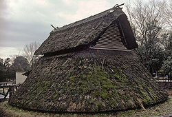
| 6
|
| 4
|
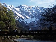
|Tateyama
Tateyama, Toyama
is a town located in Nakaniikawa District, Toyama, Japan.As of 2003, the town has an estimated population of 28,123 and a density of 91.51 persons per km². The total area is 307.31 km².-External links:*...
, Unazuki
Unazuki, Toyama
was a town located in Shimoniikawa District, Toyama, Japan.On March 31, 2006 Unazaki was merged into the city of Kurobe.As of 2003, the town had an estimated population of 6,178 and a density of 18.19 persons per km². The total area was 339.58 km²....
, Toyama
Toyama Prefecture
is a prefecture of Japan located in the Hokuriku region on Honshū island. The capital is the city of Toyama.Toyama is the leading industrial prefecture on the Japan Sea coast, and has the industrial advantage of cheap electricity due to abundant water resources....
36°37′23.18"N 137°41′11.4"E
|
|-
|
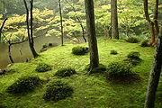
| 1
|
|
| One of the Three Great Gardens of Japan
Three Great Gardens of Japan
The , also known as "the three most famous gardens in Japan" are considered to include Kenroku-en in Kanazawa, Koraku-en in Okayama and Kairaku-en in Mito....
|Kanazawa
Kanazawa, Ishikawa
is the capital city of Ishikawa Prefecture, Japan.-Geography, climate, and population:Kanazawa sits on the Sea of Japan, bordered by the Japan Alps, Hakusan National Park and Noto Peninsula National Park. The city sits between the Sai and Asano rivers. Its total area is 467.77 km².Kanazawa's...
, Ishikawa
Ishikawa Prefecture
is a prefecture of Japan located in the Chūbu region on Honshū island. The capital is Kanazawa.- History :Ishikawa was formed from the merger of Kaga Province and the smaller Noto Province.- Geography :Ishikawa is on the Sea of Japan coast...
36°33′43.5"N 136°39′44.99"E
|
|-
|
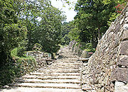
| 1
|
|
| The ruins at the same site are a Special Historic Site.
|Fukui
Fukui, Fukui
is the capital of Fukui Prefecture, Japan. The city is located in the north-central part of the prefecture on the coast of the Sea of Japan.-Demographics:...
, Fukui
Fukui Prefecture
is a prefecture of Japan located in the Chūbu region on Honshū island. The capital is the city of Fukui.- Prehistory :The Kitadani Dinosaur Quarry, on the Sugiyama River within the city limits of Katsuyama, has yielded the Fukuiraptor kitadaniensis and Fukuisaurus tetoriensis as well as an unnamed...
35°59′57.95"N 136°17′43.52"E
|
|-
|
| 5, 6
|
|
|
|Kōfu
Kofu, Yamanashi
is the capital city of Yamanashi Prefecture in Japan.As of May 1, 2011, the city had a estimate population of 197,540, with 85,794 households. The total area is 212.41 km².-History:Kōfu's name means "capital of Kai Province"...
and Kai
Kai, Yamanashi
is a city located in Yamanashi, Japan.As of March 1, 2010 the city has an estimated population of 74,196 with a population density of 1030 persons per km². The total area is 71.94 km²....
, Yamanashi
Yamanashi Prefecture
is a prefecture of Japan located in the Chūbu region of the island of Honshū. The capital is the city of Kōfu.-Pre-history to the 14th century:People have been living in the Yamanashi area for about 30,000 years...
35°44′41.64"N 138°33′59.29"E
|
|-
|
| 6
|
| 4
|
|Matsumoto
Matsumoto, Nagano
is a city located in Nagano Prefecture, Japan. Matsumoto is designated as a Special City.-Outline:The new city of Matsumoto is the city comprising the mergers of the old city of Matsumoto and four villages. Matsumoto officially absorbed those villages without creating a new municipal...
, Nagano
Nagano Prefecture
is a prefecture of Japan located in the Chūbu region of the island of Honshū. The capital is the city of Nagano.- History :Nagano was formerly known as the province of Shinano...
36°14′24.93"N 137°37′27.07"E
|
|
| 1
|
|
|
|Kyoto, Kyoto
Kyoto Prefecture
is a prefecture of Japan located in the Kansai region of the island of Honshu. The capital is the city of Kyoto.- History :Until the Meiji Restoration, the area of Kyoto prefecture was known as Yamashiro....
35°0′38.29"N 135°47′24.02"E
|
|-
|
| 1
| 8
|
|
|Kyoto, Kyoto
Kyoto Prefecture
is a prefecture of Japan located in the Kansai region of the island of Honshu. The capital is the city of Kyoto.- History :Until the Meiji Restoration, the area of Kyoto prefecture was known as Yamashiro....
35°1′35.78"N 135°47′54.31"E
|
|-
|
| 1
| 8
|
|
|Kyoto, Kyoto
Kyoto Prefecture
is a prefecture of Japan located in the Kansai region of the island of Honshu. The capital is the city of Kyoto.- History :Until the Meiji Restoration, the area of Kyoto prefecture was known as Yamashiro....
35°2′21.38"N 135°43′43.33"E
|
|-
|
| 1
|
|
| Also a historic site (hist-crit.: 8)
|Kizugawa
Kizugawa, Kyoto
is a city in southern Kyoto Prefecture, Japan. The city was founded on March 12, 2007 by the merger of the towns of Kamo, Kizu and Yamashiro, all from Sōraku District. It is the southernmost city in the prefecture...
, Kyoto
Kyoto Prefecture
is a prefecture of Japan located in the Kansai region of the island of Honshu. The capital is the city of Kyoto.- History :Until the Meiji Restoration, the area of Kyoto prefecture was known as Yamashiro....
34°42′56.16"N 135°52′22.8"E
|
|-
|
| 1
|
|
| Also a historic site (hist-crit.: 8)
|Kyoto, Kyoto
Kyoto Prefecture
is a prefecture of Japan located in the Kansai region of the island of Honshu. The capital is the city of Kyoto.- History :Until the Meiji Restoration, the area of Kyoto prefecture was known as Yamashiro....
34°59′32.5"N 135°41′3.81"E
|
|
| 1
|
|
| Also a historic site (hist-crit.: 8)
|Kyoto, Kyoto
Kyoto Prefecture
is a prefecture of Japan located in the Kansai region of the island of Honshu. The capital is the city of Kyoto.- History :Until the Meiji Restoration, the area of Kyoto prefecture was known as Yamashiro....
35°2′40.66"N 135°44′45.01"E
|
|-
|
| 1
|
|
| Also a historic site (hist-crit.: 8)
|Kyoto, Kyoto
Kyoto Prefecture
is a prefecture of Japan located in the Kansai region of the island of Honshu. The capital is the city of Kyoto.- History :Until the Meiji Restoration, the area of Kyoto prefecture was known as Yamashiro....
35°2′40.66"N 135°44′45.01"E
|
|-
|
| 1
| 8
|
|
|Kyoto, Kyoto
Kyoto Prefecture
is a prefecture of Japan located in the Kansai region of the island of Honshu. The capital is the city of Kyoto.- History :Until the Meiji Restoration, the area of Kyoto prefecture was known as Yamashiro....
34°57′6.78"N 135°49′10.2"E
|
|-
|
| 3, 8, 11
|
|
| One of the Three Views of Japan
Three Views of Japan
The is the canonical list of Japan's three most celebrated scenic sights, attributed to 1643 and scholar Hayashi Gahō. The views are of the eponymous pine-clad islands of Matsushima in Miyagi Prefecture; the pine-clad sandbar of Amanohashidate in Kyoto Prefecture; and Itsukushima Shrine in...
|Miyazu
Miyazu, Kyoto
is a city located in Kyoto, Japan.As of May 31, 2011, the city has an estimated population of 21,512 with 8,360 households and the density of 127.06 persons per km². The total area is 169.31 km²....
, Kyoto
Kyoto Prefecture
is a prefecture of Japan located in the Kansai region of the island of Honshu. The capital is the city of Kyoto.- History :Until the Meiji Restoration, the area of Kyoto prefecture was known as Yamashiro....
35°34′12.02"N 135°11′30.59"E
|
|-
|
| 1
|
|
| Also a historic site (hist-crit.: 8)
|Kyoto, Kyoto
Kyoto Prefecture
is a prefecture of Japan located in the Kansai region of the island of Honshu. The capital is the city of Kyoto.- History :Until the Meiji Restoration, the area of Kyoto prefecture was known as Yamashiro....
35°0′56.68"N 135°40′23.53"E
|
|-
|
| 1
|
|
|
|Kyoto, Kyoto
Kyoto Prefecture
is a prefecture of Japan located in the Kansai region of the island of Honshu. The capital is the city of Kyoto.- History :Until the Meiji Restoration, the area of Kyoto prefecture was known as Yamashiro....
35°0′48.27"N 135°44′57.22"E
|
|-
|
| 1, 10
|
|
|
|Kyoto, Kyoto
Kyoto Prefecture
is a prefecture of Japan located in the Kansai region of the island of Honshu. The capital is the city of Kyoto.- History :Until the Meiji Restoration, the area of Kyoto prefecture was known as Yamashiro....
35°1′11.77"N 135°42′59.03"E
|
|-
|
| 1
|
|
| Also a historic site (hist-crit: 8)
|Kyoto, Kyoto
Kyoto Prefecture
is a prefecture of Japan located in the Kansai region of the island of Honshu. The capital is the city of Kyoto.- History :Until the Meiji Restoration, the area of Kyoto prefecture was known as Yamashiro....
34°59′27.37"N 135°45′4.47"E
|
|-
|
| 1
|
|
| Also a historic site (hist-crit: 8)
|Kyoto, Kyoto
Kyoto Prefecture
is a prefecture of Japan located in the Kansai region of the island of Honshu. The capital is the city of Kyoto.- History :Until the Meiji Restoration, the area of Kyoto prefecture was known as Yamashiro....
35°2′3.81"N 135°43′5.42"E
|
|-
|
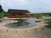
| 1
|
|
| Reconstruction of an 8th century Imperial Palace Garden with ponds and pebble shore
|Nara
Nara, Nara
is the capital city of Nara Prefecture in the Kansai region of Japan. The city occupies the northern part of Nara Prefecture, directly bordering Kyoto Prefecture...
, Nara
Nara Prefecture
is a prefecture in the Kansai region on Honshū Island, Japan. The capital is the city of Nara.-History:The present-day Nara Prefecture was created in 1887, making it independent of Osaka Prefecture....
34°41′28"N 135°47′44"E
|
|-
|
| 1
| 2, 8
|
| The ruins at the same site are a Special Historic Site.
|Nara
Nara, Nara
is the capital city of Nara Prefecture in the Kansai region of Japan. The city occupies the northern part of Nara Prefecture, directly bordering Kyoto Prefecture...
, Nara
Nara Prefecture
is a prefecture in the Kansai region on Honshū Island, Japan. The capital is the city of Nara.-History:The present-day Nara Prefecture was created in 1887, making it independent of Osaka Prefecture....
34°41′1.45"N 135°48′8.44"E
|
|-
|
| 1
|
|
| One of the Three Great Gardens of Japan
Three Great Gardens of Japan
The , also known as "the three most famous gardens in Japan" are considered to include Kenroku-en in Kanazawa, Koraku-en in Okayama and Kairaku-en in Mito....
|Okayama
Okayama, Okayama
is the capital city of Okayama Prefecture in the Chūgoku region of Japan.The city was founded on June 1, 1889. As of August 2010, the city has an estimated population of 705,224 and a population density of 893 persons per km². The total area is 789.88 km²....
, Okayama
Okayama Prefecture
is a prefecture of Japan located in the Chūgoku region on Honshū island. The capital is the city of Okayama.- History :During the Meiji Restoration, the area of Okayama Prefecture was known as Bitchū Province, Bizen Province and Mimasaka Province.- Geography :...
34°40′3.94"N 133°56′7.78"E
|
|-
|
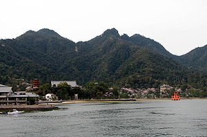
| 8
| 2,3
|
| Includes one of the Three Views of Japan
Three Views of Japan
The is the canonical list of Japan's three most celebrated scenic sights, attributed to 1643 and scholar Hayashi Gahō. The views are of the eponymous pine-clad islands of Matsushima in Miyagi Prefecture; the pine-clad sandbar of Amanohashidate in Kyoto Prefecture; and Itsukushima Shrine in...
|Hatsukaichi
Hatsukaichi, Hiroshima
is a city of some 120,000 people located in Hiroshima Prefecture, Japan. The name derives from a market traditionally held on the 20th of each month with hatsuka meaning "20th day" and ichi translating to "market"...
, Hiroshima
Hiroshima Prefecture
is a prefecture of Japan located in the Chūgoku region on Honshu island. The capital is the city of Hiroshima.- History :The area around Hiroshima was formerly divided into Bingo Province and Aki Province. This location has been a center of trade and culture since the beginning of Japan's recorded...
34°17′1.99"N 132°19′5.9"E
|
|
| 3,5,6
|
|
|
|Akiōta
Akiota, Hiroshima
is a town located in Yamagata District, Hiroshima, Japan.Akiōta was formed on October 1, 2004 from the merger of the towns of Kake and Togouchi, and the village of Tsutsuga, all from Yamagata District....
, Hiroshima
Hiroshima Prefecture
is a prefecture of Japan located in the Chūgoku region on Honshu island. The capital is the city of Hiroshima.- History :The area around Hiroshima was formerly divided into Bingo Province and Aki Province. This location has been a center of trade and culture since the beginning of Japan's recorded...
34°37′28.85"N 132°11′8.97"E
|
|-
|
| 1
|
|
|
|Takamatsu
Takamatsu, Kagawa
is a city located in central Kagawa Prefecture on the island of Shikoku in Japan, and is the seat of the prefectural government. It is designated a core city by the Japanese Government. It is a port city located on the Seto Inland Sea, and is the closest port to Honshu from Shikoku island...
, Kagawa
Kagawa Prefecture
is a prefecture of Japan located on Shikoku island. The capital is Takamatsu.- History :Kagawa was formerly known as Sanuki Province.For a brief period between August 1876 and December 1888, Kagawa was made a part of Ehime Prefecture.-Battle of Yashima:...
34°19′39.2"N 134°2′35.76"E
|
|-
|
| 3,9
|
|
|
|Karatsu
Karatsu, Saga
is a city located in Saga Prefecture on the island of Kyūshū, Japan. Its name, formed from the Japanese word roots 唐 kara , and 津 tsu , signifies its historical importance as an ancient trading port between Japan with China and Korea...
, Saga
Saga Prefecture
is located in the northwest part of the island of Kyūshū, Japan. It touches both the Sea of Japan and the Ariake Sea. The western part of the prefecture is a region famous for producing ceramics and porcelain, particularly the towns of Karatsu, Imari, and Arita...
33°26′35.99"N 130°0′34.37"E
|
|-
|
| 1, 3, 9, 10
|
|
|
|Shimabara
Shimabara, Nagasaki
is a city located on the north-eastern tip of the Shimabara Peninsula, facing Ariake Bay in the east and Mount Unzen in the west, in Nagasaki Prefecture, Kyūshū, Japan.-History:...
, Nagasaki
Nagasaki Prefecture
is a prefecture of Japan located on the island of Kyūshū. The capital is the city of Nagasaki.- History :Nagasaki Prefecture was created by merging of the western half of the former province of Hizen with the island provinces of Tsushima and Iki...
32°45′37.54"N 130°17′31.25"E
|
|-
|
| 1
|
|
|
|Naha
Naha, Okinawa
is the capital city of the Japanese prefecture of Okinawa.Naha is a coastal city located on the East China Sea coast of the southern part of Okinawa Island, the largest of the Ryukyu Islands...
, Okinawa
Okinawa Prefecture
is one of Japan's southern prefectures. It consists of hundreds of the Ryukyu Islands in a chain over long, which extends southwest from Kyūshū to Taiwan. Okinawa's capital, Naha, is located in the southern part of Okinawa Island...
26°12′14.1"N 127°42′55.32"E
|
|-
|
| 6, 7
|
|
| Also a Natural Monument (4)
|Towadako
Towadako, Aomori
was a town located in Kamikita District in central Aomori Prefecture, Japan.Hōosawa Village was founded in 1889 from the merger of the hamlets of Hōryō, Oirase, and Sawada. It changed its name to Towada Village in 1931 and was elevated to town status in 1955. In April 1975, it changed its name to...
, Aomori
Aomori Prefecture
is a prefecture of Japan located in the Tōhoku Region. The capital is the city of Aomori.- History :Until the Meiji Restoration, the area of Aomori prefecture was known as Mutsu Province....
and Kosaka
Kosaka, Akita
is a town located in Kazuno District, Akita, Japan.As of 2011, the town has an estimated population of 6,046 and a density of 29.9 persons per km². The total area is 178.00 km²....
, Akita
Akita Prefecture
is a prefecture of Japan located in the Tōhoku Region of northern Honshu, the main island of Japan. The capital is the city of Akita.- History :The area of Akita has been created from the ancient provinces of Dewa and Mutsu....
40°28′23.05"N 140°52′39.67"E
|
|-
|
| 5,6
|
|
| Also a Natural Monument (3.1)
|Kumanogawa
Kumanogawa, Wakayama
was an enclave town that belongs to Higashimuro District, Wakayama, Japan, but was located on the border between Mie and Nara prefectures.On October 1, 2005 Kumanogawa was merged into the city of Shingū....
, Wakayama
Wakayama Prefecture
is a prefecture of Japan located on the Kii Peninsula in the Kansai region on Honshū island. The capital is the city of Wakayama.- History :Present-day Wakayama is mostly the western part of the province of Kii.- 1953 Wakayama Prefecture flood disaster :...
, Kiwa
Kiwa, Mie
was a town located in Minamimuro District, Mie, Japan.On November 1, 2005 Kiwa was merged into the city of Kumano and no longer exists as an independent municipality....
, Mie
Mie Prefecture
is a prefecture of Japan which is part of the Kansai regions on Honshū island. The capital is the city of Tsu.- History :Until the Meiji Restoration, Mie prefecture was known as Ise Province and Iga Province....
and Totsukawa
Totsukawa, Nara
is a village located in the Yoshino District of Nara Prefecture, Japan. It's recognized as the largest village in Japan in terms of land area.As of 2009, the village has an estimated population of 4,029 and a density of 5.99 persons per km². The total area is 672.35 km².-History:In 1889, a...
, Nara
Nara Prefecture
is a prefecture in the Kansai region on Honshū Island, Japan. The capital is the city of Nara.-History:The present-day Nara Prefecture was created in 1887, making it independent of Osaka Prefecture....
33°52′23.24"N 135°51′27.43"E
|
|-
|
| 10
|
|
|
|Yamanashi
Yamanashi Prefecture
is a prefecture of Japan located in the Chūbu region of the island of Honshū. The capital is the city of Kōfu.-Pre-history to the 14th century:People have been living in the Yamanashi area for about 30,000 years...
, Shizuoka
Shizuoka Prefecture
is a prefecture of Japan located in the Chūbu region on Honshu island. The capital is the city of Shizuoka.- History :Shizuoka prefecture was formed from the former Tōtōmi, Suruga and Izu provinces.The area was the home of the first Tokugawa Shogun...
35°21′28.8"N 138°43′51.6"E
|
|
|
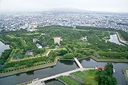
| 2
|
| Star fort
Star fort
A star fort, or trace italienne, is a fortification in the style that evolved during the age of gunpowder, when cannon came to dominate the battlefield, and was first seen in the mid-15th century in Italy....
of the Republic of Ezo
Republic of Ezo
The ' was a short-lived state established by former Tokugawa retainers in what is now known as Hokkaidō, the large but sparsely populated northernmost island in modern Japan.-Background:...
|Hakodate
Hakodate, Hokkaido
is a city and port located in Oshima Subprefecture, Hokkaido, Japan. It is the capital city of Oshima Subprefecture.Hakodate was Japan's first city whose port was opened to foreign trade in 1854 as a result of Convention of Kanagawa, and used to be the most important port in northern Japan...
, Hokkaidō
41°47′49.8"N 140°45′24.3"E
|
|
|
| 1
|
| Jōmon period
Jomon period
The is the time in Japanese prehistory from about 14,000 BC to 300 BC.The term jōmon means "cord-patterned" in Japanese. This refers to the pottery style characteristic of the Jōmon culture, and which has markings made using sticks with cords wrapped around them...
archaeological site
Archaeological site
An archaeological site is a place in which evidence of past activity is preserved , and which has been, or may be, investigated using the discipline of archaeology and represents a part of the archaeological record.Beyond this, the definition and geographical extent of a 'site' can vary widely,...
|Aomori
Aomori, Aomori
is the capital city of Aomori Prefecture, in the northern Tōhoku region of Japan. As of 2009, the city had an estimated population of 302,068 and a density of 366 persons per km². Its total area was 824.52 km².- History :...
, Aomori
Aomori Prefecture
is a prefecture of Japan located in the Tōhoku Region. The capital is the city of Aomori.- History :Until the Meiji Restoration, the area of Aomori prefecture was known as Mutsu Province....
40°48′40.24"N 140°41′44.3"E
|
|-
|
|
| 3
|
|
|Hiraizumi
Hiraizumi, Iwate
is a town located in Nishiiwai District, Iwate, Japan. It was the home of the Hiraizumi Fujiwaras for about 100 years in the late Heian era and most of the following Kamakura period. At the same time it served as the de facto capital of Oshu, an area containing nearly a third of the Japanese land...
, Iwate
Iwate Prefecture
is the second largest prefecture of Japan after Hokkaido. It is located in the Tōhoku region of Honshū island and contains the island's easternmost point. The capital is Morioka. Iwate has the lowest population density of any prefecture outside Hokkaido...
39°0′6.68"N 141°6′0.46"E
|
|-
|
|
| 3
|
|
|Hiraizumi
Hiraizumi, Iwate
is a town located in Nishiiwai District, Iwate, Japan. It was the home of the Hiraizumi Fujiwaras for about 100 years in the late Heian era and most of the following Kamakura period. At the same time it served as the de facto capital of Oshu, an area containing nearly a third of the Japanese land...
, Iwate
Iwate Prefecture
is the second largest prefecture of Japan after Hokkaido. It is located in the Tōhoku region of Honshū island and contains the island's easternmost point. The capital is Morioka. Iwate has the lowest population density of any prefecture outside Hokkaido...
38°59′36.08"N 141°6′56.81"E
|
|-
|
|
| 3
|
|
|Hiraizumi
Hiraizumi, Iwate
is a town located in Nishiiwai District, Iwate, Japan. It was the home of the Hiraizumi Fujiwaras for about 100 years in the late Heian era and most of the following Kamakura period. At the same time it served as the de facto capital of Oshu, an area containing nearly a third of the Japanese land...
, Iwate
Iwate Prefecture
is the second largest prefecture of Japan after Hokkaido. It is located in the Tōhoku region of Honshū island and contains the island's easternmost point. The capital is Morioka. Iwate has the lowest population density of any prefecture outside Hokkaido...
38°59′13.89"N 141°6′27.26"E
|
|-
|
|
| 2, 3
|
|
|Tagajō
Tagajo, Miyagi
is a city located in Miyagi Prefecture, Japan.The city was named after Taga Castle, the capital of Mutsu Province.As of 2010, the city has an estimated population of 63,256 and the population density of 3,220 persons per km². The total area is 19.64 km²....
, Miyagi
Miyagi Prefecture
is a prefecture of Japan in the Tōhoku Region on Honshu island. The capital is Sendai.- History :Miyagi Prefecture was formerly part of the province of Mutsu. Mutsu Province, on northern Honshu, was one of the last provinces to be formed as land was taken from the indigenous Emishi, and became the...
38°17′57.54"N 140°59′52.41"E
|
|-
|
|
| 1
|
|
|Kazuno
Kazuno, Akita
is a city located in Akita, Japan.As of 2011, the city has an estimated population of 33,664 and the density of 47.6 persons per km². The total area is 707.34 km².The city was founded on April 1, 1972.-External links:...
, Akita
Akita Prefecture
is a prefecture of Japan located in the Tōhoku Region of northern Honshu, the main island of Japan. The capital is the city of Akita.- History :The area of Akita has been created from the ancient provinces of Dewa and Mutsu....
40°16′16.96"N 140°48′15.06"E
|
|-
|
|
| 4
|
| Former school of the Mito Clan, founded in 1841 by Tokugawa Nariaki
Tokugawa Nariaki
Tokugawa Nariaki was a prominent Japanese daimyo who ruled the Mito domain and contributed to the rise of nationalism and the Meiji restoration.- Clan leader :...
|Mito
Mito, Ibaraki
is the capital of Ibaraki Prefecture, Japan and has a central location, moderately offset towards the coast in that prefecture. As of 2005, the city has an estimated population of 263,748 and a total area is 217.45 km², giving a population density of 1,212.91 persons per km²...
, Ibaraki
Ibaraki Prefecture
is a prefecture of Japan, located in the Kantō region on the main island of Honshu. The capital is Mito.-History:Ibaraki Prefecture was previously known as Hitachi Province...
36°22′31.54"N 140°28′38.27"E
|
|-
|
|
| 3
|
|
|Ishioka
Ishioka, Ibaraki
is a city located in Ibaraki, Japan.As of 2003, the city has an estimated population of 52,755 and the density of 885.15 persons per km². The total area is 59.60 km².The city was founded on February 11, 1954....
, Ibaraki
Ibaraki Prefecture
is a prefecture of Japan, located in the Kantō region on the main island of Honshu. The capital is Mito.-History:Ibaraki Prefecture was previously known as Hitachi Province...
36°11′48.17"N 140°16′25.38"E
|
|-
|
|
| 3
|
|
|Ishioka
Ishioka, Ibaraki
is a city located in Ibaraki, Japan.As of 2003, the city has an estimated population of 52,755 and the density of 885.15 persons per km². The total area is 59.60 km².The city was founded on February 11, 1954....
, Ibaraki
Ibaraki Prefecture
is a prefecture of Japan, located in the Kantō region on the main island of Honshu. The capital is Mito.-History:Ibaraki Prefecture was previously known as Hitachi Province...
36°12′6.18"N 140°16′3.25"E
|
|-
|
|
| 3
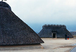
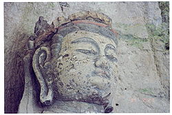
|
| Stone reliefs of Buddhist deities in a cave
|Utsunomiya
Utsunomiya, Tochigi
is the capital and most populous city of Tochigi Prefecture, Japan. In October 2010 the city had an estimated population of 510,416 and a population density of 1,224.49 people per square kilometer. The total area is 416.84 km². had a population of 888,005 in the 2000 Census...
, Tochigi
Tochigi Prefecture
is a prefecture located in the Kantō region on the island of Honshū, Japan. The capital is the city of Utsunomiya.Nikkō, whose ancient Shintō shrines and Buddhist temples UNESCO has recognized by naming them a World Heritage Site, is in this prefecture...
36°35′46.35"N 139°49′16.94"E
|
|-
|
|
| 6
| 2.1
| Three roads totalling 37 km (23 mi)
|Nikkō
Nikko, Tochigi
is a city in the mountains of Tochigi Prefecture, Japan. Approximately 140 km north of Tokyo and 35 km west of Utsunomiya, the capital of Tochigi Prefecture, it is a popular destination for Japanese and international tourists...
, Imaichi
Imaichi, Tochigi
was a city located in Tochigi Prefecture, Japan.On March 20, 2006 Imaichi, along with the town of Ashio, from Kamitsuga District, the town of Fujihara, and the village of Kuriyama, both from Shioya District, was merged into the expanded city of Nikkō...
and Kanuma
Kanuma, Tochigi
is a city located in Tochigi, Japan.As of 2010, the city has an estimated population of 102,825 and the density of 210 persons per km². The total area is 490.62 km²...
, Tochigi
Tochigi Prefecture
is a prefecture located in the Kantō region on the island of Honshū, Japan. The capital is the city of Utsunomiya.Nikkō, whose ancient Shintō shrines and Buddhist temples UNESCO has recognized by naming them a World Heritage Site, is in this prefecture...
36°35′46.35"N 139°49′16.94"E
|
|
|
| 3, 7
|
| 110 cm (43.3 in) high stone stele from 726
|Takasaki
Takasaki, Gunma
is a city located in Gunma Prefecture, Japan.The city was founded on April 1, 1900.Takasaki is a regional transportation hub because its train station is the junction of several rail lines as well as a Shinkansen stop....
, Gunma
Gunma Prefecture
is a prefecture of Japan located in the northwest corner of the Kantō region on Honshu island. Its capital is Maebashi.- History :The remains of a Paleolithic man were found at Iwajuku, Gunma Prefecture, in the early 20th century and there is a public museum there.Japan was without horses until...
36°17′8.37"N 139°0′58.21"E
|
|-
|
|
| 1, 7
|
|
|Takasaki
Takasaki, Gunma
is a city located in Gunma Prefecture, Japan.The city was founded on April 1, 1900.Takasaki is a regional transportation hub because its train station is the junction of several rail lines as well as a Shinkansen stop....
, Gunma
Gunma Prefecture
is a prefecture of Japan located in the northwest corner of the Kantō region on Honshu island. Its capital is Maebashi.- History :The remains of a Paleolithic man were found at Iwajuku, Gunma Prefecture, in the early 20th century and there is a public museum there.Japan was without horses until...
36°16′37.48"N 139°1′40.09"E
|
|-
|
|
| 2, 7
|
|
|Takasaki
Takasaki, Gunma
is a city located in Gunma Prefecture, Japan.The city was founded on April 1, 1900.Takasaki is a regional transportation hub because its train station is the junction of several rail lines as well as a Shinkansen stop....
, Gunma
Gunma Prefecture
is a prefecture of Japan located in the northwest corner of the Kantō region on Honshu island. Its capital is Maebashi.- History :The remains of a Paleolithic man were found at Iwajuku, Gunma Prefecture, in the early 20th century and there is a public museum there.Japan was without horses until...
36°15′54.1"N 138°59′46.67"E
|
|-
|
|
| 2
|
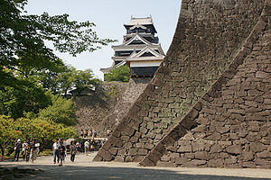
|
|Tokyo
Tokyo
, ; officially , is one of the 47 prefectures of Japan. Tokyo is the capital of Japan, the center of the Greater Tokyo Area, and the largest metropolitan area of Japan. It is the seat of the Japanese government and the Imperial Palace, and the home of the Japanese Imperial Family...
35°41′8.93"N 139°45′23.95"E
|
|
|
| 2, 3, 6, 7, 8
|
| The gardens at the same site are a Special Place of Scenic Beauty.
|Fukui
Fukui, Fukui
is the capital of Fukui Prefecture, Japan. The city is located in the north-central part of the prefecture on the coast of the Sea of Japan.-Demographics:...
, Fukui
Fukui Prefecture
is a prefecture of Japan located in the Chūbu region on Honshū island. The capital is the city of Fukui.- Prehistory :The Kitadani Dinosaur Quarry, on the Sugiyama River within the city limits of Katsuyama, has yielded the Fukuiraptor kitadaniensis and Fukuisaurus tetoriensis as well as an unnamed...
35°59′57.95"N 136°17′43.52"E
|
|-
|
|
| 1
|
| Jōmon period
Jomon period
The is the time in Japanese prehistory from about 14,000 BC to 300 BC.The term jōmon means "cord-patterned" in Japanese. This refers to the pottery style characteristic of the Jōmon culture, and which has markings made using sticks with cords wrapped around them...
archaeological site
Archaeological site
An archaeological site is a place in which evidence of past activity is preserved , and which has been, or may be, investigated using the discipline of archaeology and represents a part of the archaeological record.Beyond this, the definition and geographical extent of a 'site' can vary widely,...
|Chino
Chino, Nagano
is a city located in Nagano, Japan.As of 2003, the city has an estimated population of 55,902 and the density of 209.83 persons per km². The total area is 266.41 km².The city was founded on August 1, 1958.- Geography :*mountain**Mount Yatsugatake...
, Nagano
Nagano Prefecture
is a prefecture of Japan located in the Chūbu region of the island of Honshū. The capital is the city of Nagano.- History :Nagano was formerly known as the province of Shinano...
36°0′46.32"N 138°13′55.04"E
|
|-
|
|
| 3
|
|
|Iwata
Iwata, Shizuoka
is a city located in Shizuoka, Japan and is known for being the headquarters of the Yamaha Motor Corporation. Iwata is also home to Júbilo Iwata, a J. League soccer team, as well as Yamaha Jubilo, a rugby team. The population was 170,779 as of March 1, 2010...
, Shizuoka
Shizuoka Prefecture
is a prefecture of Japan located in the Chūbu region on Honshu island. The capital is the city of Shizuoka.- History :Shizuoka prefecture was formed from the former Tōtōmi, Suruga and Izu provinces.The area was the home of the first Tokugawa Shogun...
34°43′10.45"N 137°51′5.75"E
|
|-
|
|
| 6
|
| Set up by Tokugawa Ieyasu
Tokugawa Ieyasu
was the founder and first shogun of the Tokugawa shogunate of Japan , which ruled from the Battle of Sekigahara in 1600 until the Meiji Restoration in 1868. Ieyasu seized power in 1600, received appointment as shogun in 1603, abdicated from office in 1605, but...
|Arai
Arai, Shizuoka
is a former town located in Hamana District, Shizuoka, Japan. As of March 31, 2010, the town had an estimated population of 16,975 and a population density of 910 persons per km². The total area was 18.65 km².-Geography:...
, Shizuoka
Shizuoka Prefecture
is a prefecture of Japan located in the Chūbu region on Honshu island. The capital is the city of Shizuoka.- History :Shizuoka prefecture was formed from the former Tōtōmi, Suruga and Izu provinces.The area was the home of the first Tokugawa Shogun...
34°41′40.99"N 137°33′40.82"E
|
|-
|
|
| 1
|
| Late Yayoi
Yayoi period
The is an Iron Age era in the history of Japan traditionally dated 300 BC to 300 AD. It is named after the neighbourhood of Tokyo where archaeologists first uncovered artifacts and features from that era. Distinguishing characteristics of the Yayoi period include the appearance of new...
archaeological site
Archaeological site
An archaeological site is a place in which evidence of past activity is preserved , and which has been, or may be, investigated using the discipline of archaeology and represents a part of the archaeological record.Beyond this, the definition and geographical extent of a 'site' can vary widely,...
|Shizuoka
Shizuoka, Shizuoka
is the capital city of Shizuoka Prefecture, Japan, and the prefecture's second-largest city in terms of both population and area. It became one of Japan's 19 "designated cities" in 2005.-Geography:...
, Shizuoka
Shizuoka Prefecture
is a prefecture of Japan located in the Chūbu region on Honshu island. The capital is the city of Shizuoka.- History :Shizuoka prefecture was formed from the former Tōtōmi, Suruga and Izu provinces.The area was the home of the first Tokugawa Shogun...
34°57′22.26"N 138°24′29.74"E
|
|
|
| 2
|
|
|Nagoya
Nagoya, Aichi
is the third-largest incorporated city and the fourth most populous urban area in Japan.Located on the Pacific coast in the Chūbu region on central Honshu, it is the capital of Aichi Prefecture and is one of Japan's major ports along with those of Tokyo, Osaka, Kobe, Yokohama, Chiba, and Moji...
, Aichi
Aichi Prefecture
is a prefecture of Japan located in the Chūbu region. The region of Aichi is also known as the Tōkai region. The capital is Nagoya. It is the focus of the Chūkyō Metropolitan Area.- History :...
35°11′5.8"N 136°53′58.77"E
|
|-
|
|
| 8
|
|
|Matsusaka
Matsusaka, Mie
, sometimes called Matsuzaka, is a city located in central Mie Prefecture, on the island of Honshū, Japan. The city is famous for its beef.-Founding:...
, Mie
Mie Prefecture
is a prefecture of Japan which is part of the Kansai regions on Honshū island. The capital is the city of Tsu.- History :Until the Meiji Restoration, Mie prefecture was known as Ise Province and Iga Province....
34°34′30.9"N 136°31′32.94"E
|
|
|
| 2
|
|
|Azuchi
Azuchi, Shiga
was a town located in Gamō District, Shiga, Japan.As of 2003, the town had an estimated population of 12,217 and a density of 502.76 persons per km². The total area was 24.30 km²....
and Higashiōmi
Higashiomi, Shiga
is a city located in Shiga Prefecture, Japan.As of 2008, the city has an estimated population of 117,557 and the density of 303 persons per km². The total area is 388.58 km²....
, Shiga
Shiga Prefecture
is a prefecture of Japan, which forms part of the Kansai region on Honshu Island. The capital is the city of Ōtsu.- History :Shiga was known as Ōmi Province or Gōshū before the prefectural system was established...
35°9′21.25"N 136°8′21.79"E
|
|-
|
|
| 2
|
|
|Hikone
Hikone, Shiga
is a city located in Shiga, Japan. The city was incorporated on February 11, 1937.Hikone's most famous historical site is Hikone Castle. Its construction was begun in 1603, by Ii Naokatsu, son of the former lord, Ii Naomasa, but was not completed until 1622...
, Shiga
Shiga Prefecture
is a prefecture of Japan, which forms part of the Kansai region on Honshu Island. The capital is the city of Ōtsu.- History :Shiga was known as Ōmi Province or Gōshū before the prefectural system was established...
35°16′35.87"N 136°15′9.02"E
|
|-
|
|
| 2
|
|
|Osaka, Osaka
Osaka Prefecture
is a prefecture located in the Kansai region on Honshū, the main island of Japan. The capital is the city of Osaka. It is the center of Osaka-Kobe-Kyoto area.- History :...
34°41′14.3"N 135°31′35.04"E
|
|-
|
|
| 3
|
|
|Hirakata
Hirakata, Osaka
is a city located in north-eastern Osaka, Japan, near the prefectural borders of Nara and Kyoto. It is renowned for its chrysanthemum doll exhibition, as well as Hirakata Park — an amusement park featuring five roller coasters....
, Osaka
Osaka Prefecture
is a prefecture located in the Kansai region on Honshū, the main island of Japan. The capital is the city of Osaka. It is the center of Osaka-Kobe-Kyoto area.- History :...
34°48′55.29"N 135°39′39.15"E
|
|-
|
|
| 2
|
|
|Himeji
Himeji, Hyogo
is a city located in Hyōgo Prefecture in the Kansai region of Japan. As of April 1, 2011, the city has an estimated population of 535,945, with 206,409 households. The total area is 534.43 km².- History :...
, Hyōgo
Hyogo Prefecture
is a prefecture of Japan located in the Kansai region on Honshū island. The capital is Kobe.The prefecture's name was previously alternately spelled as Hiogo.- History :...
34°50′18.85"N 134°41′34.97"E
|
|
|
| 1
|
|
|Asuka
Asuka, Nara
is a village located in Takaichi District, Nara, Japan.As of September 1, 2007, the village has an estimated population of 6,146 and a density of 255.23 persons per km². The total area is 24.08 km².Asuka is the land where ancient palaces were located...
, Nara
Nara Prefecture
is a prefecture in the Kansai region on Honshū Island, Japan. The capital is the city of Nara.-History:The present-day Nara Prefecture was created in 1887, making it independent of Osaka Prefecture....
34°27′5.25"N 135°48′18.49"E
|
|-
|
|
| 1
|
|
|Asuka
Asuka, Nara
is a village located in Takaichi District, Nara, Japan.As of September 1, 2007, the village has an estimated population of 6,146 and a density of 255.23 persons per km². The total area is 24.08 km².Asuka is the land where ancient palaces were located...
, Nara
Nara Prefecture
is a prefecture in the Kansai region on Honshū Island, Japan. The capital is the city of Nara.-History:The present-day Nara Prefecture was created in 1887, making it independent of Osaka Prefecture....
34°27′43.94"N 135°48′23.2"E
|
|-
|
|
| 3
|
|
|Sakurai
Sakurai, Nara
is a city in Nara, Japan.As of 2007, the city had an estimated population of 63,321 with a density of 630.01 persons per km². The total area is 98.92 km².The city was founded on September 1, 1956....
, Nara
Nara Prefecture
is a prefecture in the Kansai region on Honshū Island, Japan. The capital is the city of Nara.-History:The present-day Nara Prefecture was created in 1887, making it independent of Osaka Prefecture....
34°29′4.02"N 135°49′48.09"E
|
|-
|
|
| 1
|
|
|Asuka
Asuka, Nara
is a village located in Takaichi District, Nara, Japan.As of September 1, 2007, the village has an estimated population of 6,146 and a density of 255.23 persons per km². The total area is 24.08 km².Asuka is the land where ancient palaces were located...
, Nara
Nara Prefecture
is a prefecture in the Kansai region on Honshū Island, Japan. The capital is the city of Nara.-History:The present-day Nara Prefecture was created in 1887, making it independent of Osaka Prefecture....
34°28′0.15"N 135°49′33.88"E
|
|-
|
|
| 1
|
|
|Kōryō
Koryo, Nara
is a town located in Kitakatsuragi District, Nara, Japan. It served as Japan's temporary capital from 640-642 AD, the Kudara Palace. Kudara is a reference to the Korean kingdom of Baekje....
, Nara
Nara Prefecture
is a prefecture in the Kansai region on Honshū Island, Japan. The capital is the city of Nara.-History:The present-day Nara Prefecture was created in 1887, making it independent of Osaka Prefecture....
34°33′23.06"N 135°44′27.63"E
|
|-
|
|
| 2
|
| Palace of the Fujiwara capital
Fujiwara-kyo
was the Imperial capital of Japan for sixteen years, between 694 and 710. It was located in Yamato Province , having been moved from nearby Asuka. However, in the Nihon Shoki, the name Fujiwara-kyō had never been used...
|Kashihara
Kashihara, Nara
is a city located in Nara, Japan. It is the second largest city in the prefecture.As of January 1, 2010, the city has an estimated population of 125,547 and the density of 3,176.79 persons per km². The total area is 39.52 km²....
, Nara
Nara Prefecture
is a prefecture in the Kansai region on Honshū Island, Japan. The capital is the city of Nara.-History:The present-day Nara Prefecture was created in 1887, making it independent of Osaka Prefecture....
34°30′8.71"N 135°48′26.44"E
|
|-
|
|
| 1
|
|
|Sakurai
Sakurai, Nara
is a city in Nara, Japan.As of 2007, the city had an estimated population of 63,321 with a density of 630.01 persons per km². The total area is 98.92 km².The city was founded on September 1, 1956....
, Nara
Nara Prefecture
is a prefecture in the Kansai region on Honshū Island, Japan. The capital is the city of Nara.-History:The present-day Nara Prefecture was created in 1887, making it independent of Osaka Prefecture....
34°30′13.55"N 135°50′33.21"E
|
|-
|
|
| 2
|
| Palace of the Heijō capital
Heijo-kyo
Heijō-kyō , was the capital city of Japan during most of the Nara period, from 710–40 and again from 745–84. The Palace site is a listed UNESCO World Heritage together with other places in the city of Nara Heijō-kyō (平城京, also Heizei-kyō, sometimes Nara no miyako), was the capital city of Japan...
; the gardens at the same site are a Special Place of Scenic Beauty
|Nara
Nara, Nara
is the capital city of Nara Prefecture in the Kansai region of Japan. The city occupies the northern part of Nara Prefecture, directly bordering Kyoto Prefecture...
, Nara
Nara Prefecture
is a prefecture in the Kansai region on Honshū Island, Japan. The capital is the city of Nara.-History:The present-day Nara Prefecture was created in 1887, making it independent of Osaka Prefecture....
34°41′28.46"N 135°47′42.02"E
|
|-
|
|
| 3
|
| Yakushi-ji
Yakushi-ji
is one of the most famous imperial and ancient Buddhist temples in Japan, located in Nara. The temple is the headquarters of the Hossō school of Japanese Buddhism...
of the Fujiwara capital
Fujiwara-kyo
was the Imperial capital of Japan for sixteen years, between 694 and 710. It was located in Yamato Province , having been moved from nearby Asuka. However, in the Nihon Shoki, the name Fujiwara-kyō had never been used...
|Kashihara
Kashihara, Nara
is a city located in Nara, Japan. It is the second largest city in the prefecture.As of January 1, 2010, the city has an estimated population of 125,547 and the density of 3,176.79 persons per km². The total area is 39.52 km²....
, Nara
Nara Prefecture
is a prefecture in the Kansai region on Honshū Island, Japan. The capital is the city of Nara.-History:The present-day Nara Prefecture was created in 1887, making it independent of Osaka Prefecture....
34°29′33.88"N 135°48′0.95"E
|
|-
|
|
| 1
|
|
|Wakayama
Wakayama, Wakayama
is the capital city of Wakayama Prefecture in the Kansai region of Japan.-Background:Wakayama occupies 4% of the land area and has 40% of Wakayama prefecture's population. The city was founded on April 1, 1889....
, Wakayama
Wakayama Prefecture
is a prefecture of Japan located on the Kii Peninsula in the Kansai region on Honshū island. The capital is the city of Wakayama.- History :Present-day Wakayama is mostly the western part of the province of Kii.- 1953 Wakayama Prefecture flood disaster :...
34°13′33.08"N 135°13′38.9"E
|
|-
|
|
| 3
|
|
|Tōhaku
Tohaku, Tottori
was a town located in Tōhaku District, Tottori, Japan.On September 1, 2004 Tōhaku was merged into the town of Akasaki, also from Tōhaku District, to form the new town of Kotoura....
, Tottori
Tottori Prefecture
is a prefecture of Japan located in the Chūgoku region. The capital is the city of Tottori. It is the least populous prefecture in Japan.- History :Before the Meiji Restoration, Tottori encompassed the old provinces of Hōki and Inaba...
35°28′53.65"N 133°42′41.13"E
|
|-
|
|
| 4
|
|
|Bizen
Bizen, Okayama
is a city located in Okayama, Japan. The city is particularly famous for its Bizen-yaki pottery. It is also home to literary critic Hakuchō Masamune's birthplace, which is now a museum....
, Okayama
Okayama Prefecture
is a prefecture of Japan located in the Chūgoku region on Honshū island. The capital is the city of Okayama.- History :During the Meiji Restoration, the area of Okayama Prefecture was known as Bitchū Province, Bizen Province and Mimasaka Province.- Geography :...
34°47′46.77"N 134°13′10.23"E
|
|-
|
|
| 4, 8
|
| Chazan Kan (1748–1827) was a Confucian scholar.
|Fukuyama
Fukuyama, Hiroshima
is a city located on the Ashida River in Hiroshima Prefecture, Japan.As of January 31, 2010, the city has an estimated population of 465,238 and a population density of 898.02 persons per km². The total area is 461.23 km². After Hiroshima City, it is the largest city in Hiroshima Prefecture...
, Hiroshima
Hiroshima Prefecture
is a prefecture of Japan located in the Chūgoku region on Honshu island. The capital is the city of Hiroshima.- History :The area around Hiroshima was formerly divided into Bingo Province and Aki Province. This location has been a center of trade and culture since the beginning of Japan's recorded...
34°32′41.26"N 133°23′4.1"E
|
|-
|
|
| 3
|
| Temple 80 of the Shikoku pilgrimage
Shikoku Pilgrimage
The or is a multi-site pilgrimage of 88 temples associated with the Buddhist monk Kūkai on the island of Shikoku, Japan. A popular and distinctive feature of the island's cultural landscape, and with a long history, large numbers of pilgrims still undertake the journey for a variety of ascetic,...
|Takamatsu
Takamatsu, Kagawa
is a city located in central Kagawa Prefecture on the island of Shikoku in Japan, and is the seat of the prefectural government. It is designated a core city by the Japanese Government. It is a port city located on the Seto Inland Sea, and is the closest port to Honshu from Shikoku island...
, Kagawa
Kagawa Prefecture
is a prefecture of Japan located on Shikoku island. The capital is Takamatsu.- History :Kagawa was formerly known as Sanuki Province.For a brief period between August 1876 and December 1888, Kagawa was made a part of Ehime Prefecture.-Battle of Yashima:...
34°18′13.18"N 133°56′39.65"E
|
|-
|
|
| 1
|
|
|Keisen
Keisen, Fukuoka
is a town located in Kaho District, Fukuoka, Japan.As of 2003, the town has an estimated population of 14,625 and a density of 728.70 persons per km². The total area is 20.07 km².Keisen was home to Fukuoka POW Camp in 1944 during World War II...
, Fukuoka
Fukuoka Prefecture
is a prefecture of Japan located on Kyūshū Island. The capital is the city of Fukuoka.- History :Fukuoka Prefecture includes the former provinces of Chikugo, Chikuzen, and Buzen....
33°35′19.47"N 130°39′49.84"E
|
|-
|
|
| 2
|
| Low embankment built in 664 by the Dazaifu (大宰府), the imperial office governing Kyūshū, against an invasion from Tang Dynasty
Tang Dynasty
The Tang Dynasty was an imperial dynasty of China preceded by the Sui Dynasty and followed by the Five Dynasties and Ten Kingdoms Period. It was founded by the Li family, who seized power during the decline and collapse of the Sui Empire...
China and Korea
|Dazaifu
Dazaifu, Fukuoka
is a city located in Fukuoka Prefecture, Japan. Nearby cities include Ōnojō and Chikushino. Although mostly urban, it does have arable land used for paddy fields and market gardening....
, Kasuga
Kasuga, Fukuoka
is a city located in Fukuoka, Japan.As of 2008, the city has an estimated population of 107,604 and the density of 7,600 persons per km². The total area is 14.15 km². The city was founded on April 1, 1972. It is directly south of Fukuoka City, and west of Onojo. It also has a border with Nakagawa...
and Ōnojō
Onojo, Fukuoka
is an area located in Fukuoka Prefecture, Japan. Its name is made up of the kanji for 'big', 'field', and 'castle'. It is mostly a southern suburb of the city of Fukuoka, and has a border to the northwest with the Hakata-ku area of the city. It also shares borders with Dazaifu and Kasuga, Umi,...
, Fukuoka
Fukuoka Prefecture
is a prefecture of Japan located on Kyūshū Island. The capital is the city of Fukuoka.- History :Fukuoka Prefecture includes the former provinces of Chikugo, Chikuzen, and Buzen....
33°31′2.41"N 130°29′28.42"E
|
|-
|
|
| 2
|
| Ruins of the governmental office with jurisdiction over Kyūshū
Kyushu
is the third largest island of Japan and most southwesterly of its four main islands. Its alternate ancient names include , , and . The historical regional name is referred to Kyushu and its surrounding islands....
|Dazaifu
Dazaifu, Fukuoka
is a city located in Fukuoka Prefecture, Japan. Nearby cities include Ōnojō and Chikushino. Although mostly urban, it does have arable land used for paddy fields and market gardening....
, Fukuoka
Fukuoka Prefecture
is a prefecture of Japan located on Kyūshū Island. The capital is the city of Fukuoka.- History :Fukuoka Prefecture includes the former provinces of Chikugo, Chikuzen, and Buzen....
33°30′52.43"N 130°30′54.55"E
|
|-
|
|
| 2, 3
|
| Asuka period
Asuka period
The , was a period in the history of Japan lasting from 538 to 710 , although its beginning could be said to overlap with the preceding Kofun period...
castle
|Dazaifu
Dazaifu, Fukuoka
is a city located in Fukuoka Prefecture, Japan. Nearby cities include Ōnojō and Chikushino. Although mostly urban, it does have arable land used for paddy fields and market gardening....
, Umi
Umi, Fukuoka
is a town located in Kasuya District, Fukuoka, Japan.As of 2003, the town has an estimated population of 38,545 and a density of 1,275.48 persons per km². The total area is 30.22 km²....
and Ōnojō
Onojo, Fukuoka
is an area located in Fukuoka Prefecture, Japan. Its name is made up of the kanji for 'big', 'field', and 'castle'. It is mostly a southern suburb of the city of Fukuoka, and has a border to the northwest with the Hakata-ku area of the city. It also shares borders with Dazaifu and Kasuga, Umi,...
, Fukuoka
Fukuoka Prefecture
is a prefecture of Japan located on Kyūshū Island. The capital is the city of Fukuoka.- History :Fukuoka Prefecture includes the former provinces of Chikugo, Chikuzen, and Buzen....
33°31′16.9"N 130°30′54.01"E
|
|-
|
|
| 1
|
| Yayoi period
Yayoi period
The is an Iron Age era in the history of Japan traditionally dated 300 BC to 300 AD. It is named after the neighbourhood of Tokyo where archaeologists first uncovered artifacts and features from that era. Distinguishing characteristics of the Yayoi period include the appearance of new...
archaeological site
Archaeological site
An archaeological site is a place in which evidence of past activity is preserved , and which has been, or may be, investigated using the discipline of archaeology and represents a part of the archaeological record.Beyond this, the definition and geographical extent of a 'site' can vary widely,...
|Yoshinogari
Yoshinogari, Saga
is a town located in Kanzaki District, Saga Prefecture, Japan. It is the result of a merger between the town of Mitagawa, and the village of Higashisefuri, both from Kanzaki District, on March 1, 2006.-Geography:...
, Saga
Saga Prefecture
is located in the northwest part of the island of Kyūshū, Japan. It touches both the Sea of Japan and the Ariake Sea. The western part of the prefecture is a region famous for producing ceramics and porcelain, particularly the towns of Karatsu, Imari, and Arita...
33°19′25.18"N 130°23′6.43"E
|
|
|
| 2
|
|
|Chinzei
Chinzei, Saga
was a town located in Higashimatsuura District, Saga, Japan.On January 1, 2005 Chinzei, along with the towns of Hamatama, Hizen, Kyūragi, Ōchi and Yobuko, and the village of Kitahata, all from Higashimatsuura District, was merged into the expanded city of Karatsu....
, Yobuko
Yobuko, Saga
was a town located in the Higashimatsuura District of Saga, Japan.On January 1, 2005 Yobuko, along with the towns of Chinzei, Hamatama, Hizen, Kyūragi and Ōchi, and the village of Kitahata, all from Higashimatsuura District, was merged into the expanded city of Karatsu.As of 2003, the town had an...
and Genkai
Genkai, Saga
is a town located in Higashimatsuura District, Saga, Japan. It has an area of 36.00 km² and as of February 1, 2009 has a population of 6,496. It is currently the only municipality in Higashimatsuura District...
, Saga
Saga Prefecture
is located in the northwest part of the island of Kyūshū, Japan. It touches both the Sea of Japan and the Ariake Sea. The western part of the prefecture is a region famous for producing ceramics and porcelain, particularly the towns of Karatsu, Imari, and Arita...
33°31′48.65"N 129°52′9.75"E
|
|-
|
|
| 2
|
| Asuka period
Asuka period
The , was a period in the history of Japan lasting from 538 to 710 , although its beginning could be said to overlap with the preceding Kofun period...
mountain castle
|Tsushima
Tsushima, Nagasaki
is a city governed by Nagasaki Prefecture, Japan. It is the only city of Tsushima Subprefecture and it encompasses all of Tsushima Island Archipelago, which lies in the Tsushima Strait north of Nagasaki on the western side of Kyūshū, the southernmost mainland island of Japan. the city has an...
, Nagasaki
Nagasaki Prefecture
is a prefecture of Japan located on the island of Kyūshū. The capital is the city of Nagasaki.- History :Nagasaki Prefecture was created by merging of the western half of the former province of Hizen with the island provinces of Tsushima and Iki...
34°16′6.07"N 129°18′49.69"E
|
|-
|
|
| 1
|
|
|Iki
Iki, Nagasaki
is a city located at Iki Island in Nagasaki, Japan. It is located approximately 80 kilometers northeast of Fukuoka on mainland Kyūshū. The city consists of five inhabited and 17 uninhabited islands, and its entire area is within the Iki-Tsushima Quasi-National Park...
, Nagasaki
Nagasaki Prefecture
is a prefecture of Japan located on the island of Kyūshū. The capital is the city of Nagasaki.- History :Nagasaki Prefecture was created by merging of the western half of the former province of Hizen with the island provinces of Tsushima and Iki...
33°45′48.68"N 129°44′55.04"E
|
|-
|
|
| 2
|
|
|Kumamoto
Kumamoto, Kumamoto
is the capital city of Kumamoto Prefecture on the island of Kyushu, Japan. Greater Kumamoto has a population of 1,460,000, as of the 2000 census...
, Kumamoto
Kumamoto Prefecture
is a prefecture of Japan located on Kyushu Island. The capital is the city of Kumamoto.- History :Historically the area was called Higo Province; and the province was renamed Kumamoto during the Meiji Restoration. The creation of prefectures was part of the abolition of the feudal system...
32°48′20.55"N 130°42′21.21"E
|
|-
|
|
| 3
|
|
|Usuki
Usuki, Oita
is a city located on the east coast of Ōita Prefecture, Japan. It is famous for its Usuki Stone Buddhas, a national treasure, and its soy sauce production. Recently it has become known for having the look and feel of a Japanese castle town...
, Ōita
Oita Prefecture
is a prefecture of Japan on Kyūshū Island. The prefectural capital is the city of Ōita.- History :Around the 6th century Kyushu consisted of four regions: Tsukushi-no-kuni 筑紫国, Hi-no-kuni 肥国, and Toyo no kuni...
33°5′26.18"N 131°45′47.04"E
|
|-
|
|
| 1
|
|
|Saito
Saito, Miyazaki
is a city located in Miyazaki, Japan.As of 2003, the city has an estimated population of 34,676 and the density of 79.07 persons per km². The total area is 438.56 km².The agricultural products of Saito include green peppers, cucumbers and sweet corn...
, Miyazaki
Miyazaki Prefecture
is a prefecture of Japan located on the island of Kyushu. The capital is the city of Miyazaki.- History :Historically, after the Meiji Restoration, Hyūga Province was renamed Miyazaki Prefecture....
32°7′14.95"N 131°23′17.84"E
|
|-
|
|
| 2
|
|
|Chikushino
Chikushino, Fukuoka
is a city located in Fukuoka, Japan.Bordering on Dazaifu, Chikushino is essentially a southern suburb of Fukuoka City. As of 2010, the city has an estimated population of 100,397. The total area is 87.78 km². The Tenjin Ōmuta Line runs through Chikushino at Murasaki Station and Asakuragaidō...
, Fukuoka
Fukuoka Prefecture
is a prefecture of Japan located on Kyūshū Island. The capital is the city of Fukuoka.- History :Fukuoka Prefecture includes the former provinces of Chikugo, Chikuzen, and Buzen....
and Kiyama
Kiyama, Saga
is a town located in Miyaki District, Saga Prefecture, Japan on the island of Kyūshū. It can be considered part of an economic sphere with nearby cities Tosu in Saga Prefecture and Ogōri and Kurume in Fukuoka Prefecture...
, Saga
Saga Prefecture
is located in the northwest part of the island of Kyūshū, Japan. It touches both the Sea of Japan and the Ariake Sea. The western part of the prefecture is a region famous for producing ceramics and porcelain, particularly the towns of Karatsu, Imari, and Arita...
33°26′39.34"N 130°30′36.09"E
|
|-
|
|
|
| 2.3
|
|Samani
Samani, Hokkaido
, is a town located in Samani District, Hidaka, Hokkaidō, Japan.As of 2008, the town has an estimated population of 5,466 and a density of 15.84 persons per km2...
, Hokkaidō
42°6′25.35"N 143°1′41.89"E
|
|-
|
|
|
| 2.12, 2.8
|
|Akan
Akan, Hokkaido
was a town located in Akan District, Kushiro Subprefecture, Hokkaidō.As of September 30, 2004 it had an estimated population of 6,518 and an area of 739.25 km²...
, Hokkaidō
43°27′1.54"N 144°5′57.93"E
|
|
|
|
| 3.10
|
|Sōbetsu
Sobetsu, Hokkaido
is a town located in Usu District, Iburi, Hokkaidō, Japan.As of 2007, the town has an estimated population of 3,046 and a density of 17.93 persons per km². The total area is 205.04 km².Sōbetsu has been twinned with Kemijärvi, in Finland since 1993....
, Hokkaidō
42°32′37.17"N 140°51′51.77"E
|
|-
|
|
|
| 4
|
|Kamikawa
Kamikawa, Hokkaido
is a town located in Kamikawa District, Kamikawa, Hokkaidō, Japan.As of 2007, the town has an estimated population of 4,540 and a density of 5.05 persons per km². The total area is 1,049.24 km²....
, Higashikawa
Higashikawa, Hokkaido
is a town located in Kamikawa District, Kamikawa, Hokkaidō, Japan.As of 2007, the town has an estimated population of 7,740 and a density of 31.39 persons per km²...
, Biei
Biei, Hokkaido
is a town located in Kamikawa District, Kamikawa, Hokkaidō, Japan.As of 2007, the town has an estimated population of 11,313 and a density of 16.7 persons per km². The total area is 677.16 km²....
and Shintoku
Shintoku, Hokkaido
is a town located in Kamikawa District, Tokachi, Hokkaidō, Japan.As of 2007, the town has an estimated population of 6,993 and a density of 6.98 persons per km². The total area is 1,063.79 km². Surrounding towns include Sahoro, Shimizu, and Shikaoi....
, Hokkaidō
43°40′58.87"N 142°53′55.78"E
|
|
|
|
| 2.2
|
|Kitahiroshima
Kitahiroshima, Hokkaido
is a city located in Ishikari, Hokkaidō, Japan. Its name, Kitahiroshima-shi, is translated as "North-Hiroshima city", or, more loosely, "city of North-Hiroshima", for 'kita' and 'shi' are the Japanese words for 'north' and 'city', respectively...
, Hokkaidō
43°3′12.46"N 141°30′3.09"E
|
|-
|
|
|
| 1.2
| Whooper Swan
Whooper Swan
The Whooper Swan , Cygnus cygnus, is a large Northern Hemisphere swan. It is the Eurasian counterpart of the North American Trumpeter Swan. An old name for the Whooper Swan is Elk; it is so called in Francis Willughby and John Ray's Ornithology of 1676.-Description:The Whooper Swan is similar in...
s
|Hiranai
Hiranai, Aomori
is a town located in the Higashitsugaru District of northeastern Aomori Prefecture in the Tōhoku region of Japan. As of 2009, the town had an estimated population of 12,470and a density of 57.5 persons per km². Its total area was 217.00 km².-Geography:...
, Aomori
Aomori Prefecture
is a prefecture of Japan located in the Tōhoku Region. The capital is the city of Aomori.- History :Until the Meiji Restoration, the area of Aomori prefecture was known as Mutsu Province....
40°56′14.09"N 140°58′23.88"E
|
|-
|
|
|
| 3.8
|
|Kitakami
Kitakami, Iwate
is a city located in Iwate Prefecture on the main island of Japan.- History :The first city of Kitakami was founded on April 1, 1954.The current and the second city of Kitakami was founded on April 1, 1991 when the first city merged with the villages of Ezuriko and Waga .- Sightseeing :The city is...
, Iwate
Iwate Prefecture
is the second largest prefecture of Japan after Hokkaido. It is located in the Tōhoku region of Honshū island and contains the island's easternmost point. The capital is Morioka. Iwate has the lowest population density of any prefecture outside Hokkaido...
39°12′36.64"N 140°52′55.74"E
|
|-
|
|
|
| 3.1
| 15–20 Million years old
|Ichinohe
Ichinohe, Iwate
is a town located in Ninohe District, Iwate, Japan.As of 2003, the town has an estimated population of 16,028 and a population density of 53.41 persons per km². The total area is 300.11 km².-External links:*...
, Iwate
Iwate Prefecture
is the second largest prefecture of Japan after Hokkaido. It is located in the Tōhoku region of Honshū island and contains the island's easternmost point. The capital is Morioka. Iwate has the lowest population density of any prefecture outside Hokkaido...
40°11′24.78"N 141°20′4.42"E
|
|-
|
|
|
| 3.5, 3.10
|
|Nishine
Nishine, Iwate
was a town located in Iwate District, Iwate, Japan.On September 1, 2005 Nishine, along with the town of Ashiro, and the village of Matsuo, was merged to form the city of Hachimantai and no longer exists as an independent municipality....
, Iwate
Iwate Prefecture
is the second largest prefecture of Japan after Hokkaido. It is located in the Tōhoku region of Honshū island and contains the island's easternmost point. The capital is Morioka. Iwate has the lowest population density of any prefecture outside Hokkaido...
39°52′30.82"N 141°2′51.16"E
|
|-
|
|
|
| 2.3
|
|Hanamaki
Hanamaki, Iwate
is a city located in Iwate Prefecture, Japan. As of March 31, 2011, the city has an estimated total population of 102,455, with a household number of 35,831. Hanamaki is most famous as the birthplace of Kenji Miyazawa and for its onsen. The city recently celebrated the 50th anniversary since its...
, Tōno
Tono, Iwate
is a city located in Iwate, Japan. The city of Tōno lies near the center of Iwate Prefecture in the floodplain of the Sarugaishi River. It is known as "The City of Folklore" for its rural nature, its preservation of traditional culture and especially for the collection of folktales, Tōno...
and Kawai
Kawai, Iwate
Kawai was a village located in Shimohei District, Iwate, Japan.As of 2003, the village had an estimated population of 3,469 and a density of 6.16 persons per km². The total area was 563.07 km²....
, Iwate
Iwate Prefecture
is the second largest prefecture of Japan after Hokkaido. It is located in the Tōhoku region of Honshū island and contains the island's easternmost point. The capital is Morioka. Iwate has the lowest population density of any prefecture outside Hokkaido...
39°31′53.71"N 141°28′26.53"E
|
|-
|
|
|
| 3.8
|
|Ōsaki
Osaki, Miyagi
is a city located in Miyagi Prefecture, Japan. Its area is 796.76 km², and its population was 135,129 as of November 1, 2010. The area was hard-hit during the 2011 Tōhoku earthquake.The city was formed on March 31, 2006, when several jurisdictions merged together....
, Miyagi
Miyagi Prefecture
is a prefecture of Japan in the Tōhoku Region on Honshu island. The capital is Sendai.- History :Miyagi Prefecture was formerly part of the province of Mutsu. Mutsu Province, on northern Honshu, was one of the last provinces to be formed as land was taken from the indigenous Emishi, and became the...
38°48′0.19"N 140°38′52.81"E
|
|-
|
|
|
| 3.1, 3.8
| Hokutolite is a type of radioactive baryte.
|Semboku, Akita
Akita Prefecture
is a prefecture of Japan located in the Tōhoku Region of northern Honshu, the main island of Japan. The capital is the city of Akita.- History :The area of Akita has been created from the ancient provinces of Dewa and Mutsu....
39°57′42.57"N 140°43′42.18"E
|
|-
|
|
|
| 2.1
|
|Tsuruoka
Tsuruoka, Yamagata
is a city located in the Shonai region of Yamagata Prefecture, Japan.Tsuruoka is the second largest city in Yamagata Prefecture after Yamagata City...
, Yamagata
Yamagata Prefecture
-Fruit:Yamagata Prefecture is the largest producer of cherries and pears in Japan. A large quantity of other kinds of fruits such as grapes, apples, peaches, melons, persimmons and watermelons are also produced.- Demographics :...
38°42′13.91"N 139°58′13.33"E
|
|
|
|
| 2.1
| More than 1000 year old, and perimeter larger than , largest zelkova tree in Japan
|Higashine
Higashine, Yamagata
is a city located in Yamagata Prefecture, Japan, founded on November 3, 1958.The city name means 'east root'. As of 2008, the city has an estimated population of 46,138 and a population density of 223 people per km². The total area is 207.17 km². The city's western border is the Mogami River. The...
, Yamagata
Yamagata Prefecture
-Fruit:Yamagata Prefecture is the largest producer of cherries and pears in Japan. A large quantity of other kinds of fruits such as grapes, apples, peaches, melons, persimmons and watermelons are also produced.- Demographics :...
38°26′31.16"N 140°24′6.28"E
|
|-
|
|
|
| 2.12
| A species of butterwort
Pinguicula
The butterworts are a group of carnivorous plants comprising the genus Pinguicula. Members of this genus use sticky, glandular leaves to lure, trap, and digest insects in order to supplement the poor mineral nutrition they obtain from the environments. Of the roughly 80 currently known species, 12...
endemic to Nikkō National Park
Nikko National Park
is a national park in the Kantō region, on the main island of Honshū in Japan. The park spreads over four prefectures: Tochigi, Gunma, Fukushima, and Niigata.Notable attractions include:* Nikkō Tōshō-gū* Lake Chūzenji* Kegon Falls* Ryūzu Falls* Mount Nantai...
|Nikkō
Nikko, Tochigi
is a city in the mountains of Tochigi Prefecture, Japan. Approximately 140 km north of Tokyo and 35 km west of Utsunomiya, the capital of Tochigi Prefecture, it is a popular destination for Japanese and international tourists...
, Tochigi
Tochigi Prefecture
is a prefecture located in the Kantō region on the island of Honshū, Japan. The capital is the city of Utsunomiya.Nikkō, whose ancient Shintō shrines and Buddhist temples UNESCO has recognized by naming them a World Heritage Site, is in this prefecture...
36°40′27.13"N 139°21′42.9"E
|
|
|
|
| 3.2, 3.7, 3.10
|
|Tsumagoi
Tsumagoi, Gunma
is a village located in Agatsuma District, Gunma, Japan.As of September 1, 2007, the village has an estimated population of 10,743 and a density of 31.19 persons per km². The total area is 337.51 km².-Geography:...
, Gunma
Gunma Prefecture
is a prefecture of Japan located in the northwest corner of the Kantō region on Honshu island. Its capital is Maebashi.- History :The remains of a Paleolithic man were found at Iwajuku, Gunma Prefecture, in the early 20th century and there is a public museum there.Japan was without horses until...
36°26′53.57"N 138°30′56.25"E
|
|-
|
|
|
| 2.1
|
|Kasukabe
Kasukabe, Saitama
is a city in eastern Saitama, Japan, approximately north of Tokyo. It was formerly located in Kitakatsushika and Minamisaitama districts. Kasukabe once prospered as part of the Nikkō Kaidō highway, an important trade route that linked Edo with Nikkō.-Overview:...
, Saitama
Saitama Prefecture
is a prefecture of Japan located in the Kantō region of the island of Honshu. The capital is the city of Saitama.This prefecture is part of the Greater Tokyo Area, and most of Saitama's cities can be described as suburbs of Tokyo, to which a large amount of residents commute each day.- History...
35°59′5.83"N 139°46′24.07"E
|
|-
|
|
|
| 3.1, 3.5
|
|Kamikawa
Kamikawa, Saitama
is a town located in Kodama District, Saitama, Japan. Situated on the banks of the Kanna River. As of 2003, the town has an estimated population of 13,704 and a density of 591.45 persons per km². The total area is 23.17 km²....
, Saitama
Saitama Prefecture
is a prefecture of Japan located in the Kantō region of the island of Honshu. The capital is the city of Saitama.This prefecture is part of the Greater Tokyo Area, and most of Saitama's cities can be described as suburbs of Tokyo, to which a large amount of residents commute each day.- History...
36°10′45.91"N 139°4′14.18"E
|
|-
|
|
|
| 2.4
|
|Saitama
Saitama, Saitama
' is the capital and the most populous city of Saitama Prefecture in Japan, situated in the south-east of the prefecture. Its area incorporates the former cities of Urawa, Ōmiya, Yono and Iwatsuki. It is a city designated by government ordinance...
, Saitama
Saitama Prefecture
is a prefecture of Japan located in the Kantō region of the island of Honshu. The capital is the city of Saitama.This prefecture is part of the Greater Tokyo Area, and most of Saitama's cities can be described as suburbs of Tokyo, to which a large amount of residents commute each day.- History...
35°50′17.41"N 139°36′56.66"E
|
|-
|
|
|
| 1.3
|
|Kamogawa
Kamogawa, Chiba
is a city located in Chiba Prefecture, Japan.As of 2010, the city had an estimated population of 35,257 and a population density of 184 persons per km². The total area was 191.30 km²...
, Chiba
Chiba Prefecture
is a prefecture of Japan located in the Kantō region and the Greater Tokyo Area. Its capital is Chiba City.- History :Chiba Prefecture was established on June 15, 1873 with the merger of Kisarazu Prefecture and Inba Prefecture...
35°7′5.98"N 140°11′28.67"E
|
|-
|
|
|
| 2.1
| Single tree, 7.9 m (25.9 ft) circumference; species is native to Ōshima
Izu Oshima
is a volcanic island in the Izu Islands and administered by the Tokyo Metropolitan government, Japan, lies about 100 km south of Tokyo, 22 km east of the Izu Peninsula and 36 km southwest of Bōsō Peninsula. serves as the local government of the island...
and Izu Peninsula
Izu Peninsula
The is a large mountainous peninsula with deeply indented coasts to the west of Tokyo on the Pacific coast of the island of Honshū, Japan. Formerly the eponymous Izu Province, Izu peninsula is now a part of Shizuoka Prefecture...
|Ōshima
Izu Oshima
is a volcanic island in the Izu Islands and administered by the Tokyo Metropolitan government, Japan, lies about 100 km south of Tokyo, 22 km east of the Izu Peninsula and 36 km southwest of Bōsō Peninsula. serves as the local government of the island...
, Tokyo
34°45′49.01"N 139°26′3.07"E
|
|-
|
|
|
| 1.3
|
|Toyama
Toyama, Toyama
is the capital city of Toyama Prefecture, Japan, located on the coast of the Sea of Japan in the Chūbu region on central Honshū, about 200 km north of the city of Nagoya and 300 km northwest of Tokyo....
and Uozu
Uozu, Toyama
is a city located in the eastern part of Toyama, Japan between Namerikawa and Kurobe, stretching from Toyama Bay and the Japan Sea in the northwest to tall mountain ranges in the southeast. The highest mountains in Uozu are Sougadake and Kekachiyama, and the highest elevation in Uozu is 2,414 m...
, Toyama
Toyama Prefecture
is a prefecture of Japan located in the Hokuriku region on Honshū island. The capital is the city of Toyama.Toyama is the leading industrial prefecture on the Japan Sea coast, and has the industrial advantage of cheap electricity due to abundant water resources....
36°46′36.01"N 137°20′40.69"E
|
|-
|
|
|
| 3.1, 3.5
| Tree trunks of a cedar
Cryptomeria
Cryptomeria is a monotypic genus of conifer in the cypress family Cupressaceae formerly belonging to the family Taxodiaceae; it includes only one species, Cryptomeria japonica . It is endemic to Japan, where it is known as Sugi...
forest partially buried about 2000 years ago; largest has a circumference of ca. 12 m (39.4 ft)
|Shakadō, Uozu
Uozu, Toyama
is a city located in the eastern part of Toyama, Japan between Namerikawa and Kurobe, stretching from Toyama Bay and the Japan Sea in the northwest to tall mountain ranges in the southeast. The highest mountains in Uozu are Sougadake and Kekachiyama, and the highest elevation in Uozu is 2,414 m...
, Toyama
Toyama Prefecture
is a prefecture of Japan located in the Hokuriku region on Honshū island. The capital is the city of Toyama.Toyama is the leading industrial prefecture on the Japan Sea coast, and has the industrial advantage of cheap electricity due to abundant water resources....
36°49′31.5"N 137°24′23.53"E
|
|-
|
|
|
| 3.11
|
|Toyama
Toyama, Toyama
is the capital city of Toyama Prefecture, Japan, located on the coast of the Sea of Japan in the Chūbu region on central Honshū, about 200 km north of the city of Nagoya and 300 km northwest of Tokyo....
, Toyama
Toyama Prefecture
is a prefecture of Japan located in the Hokuriku region on Honshū island. The capital is the city of Toyama.Toyama is the leading industrial prefecture on the Japan Sea coast, and has the industrial advantage of cheap electricity due to abundant water resources....
36°28′5.64"N 137°32′38.48"E
|
|-
|
|
|
| 3.8
|
|Hakusan
Hakusan, Ishikawa
is a city located in Ishikawa, Japan.The city was founded on February 1, 2005 from the merger of the city of Mattō with seven towns and villages from Ishikawa District. As of April 1, 2008 population data, the city has an estimated population of 110,654 and a density of 147 persons per km²...
, Ishikawa
Ishikawa Prefecture
is a prefecture of Japan located in the Chūbu region on Honshū island. The capital is Kanazawa.- History :Ishikawa was formed from the merger of Kaga Province and the smaller Noto Province.- Geography :Ishikawa is on the Sea of Japan coast...
36°13′39.32"N 136°46′11.69"E
|
|-
|
|
|
| 3.6, 3.10
|
|Narusawa
Narusawa, Yamanashi
is a village located in Minamitsuru District, Yamanashi, Japan.As of 2003, the village has an estimated population of 2,979 and a density of 33.26 persons per km². The total area is 89.56 km².-External links:*...
, Yamanashi
Yamanashi Prefecture
is a prefecture of Japan located in the Chūbu region of the island of Honshū. The capital is the city of Kōfu.-Pre-history to the 14th century:People have been living in the Yamanashi area for about 30,000 years...
35°25′34.06"N 138°42′3.05"E
|
|-
|
|
|
| 3.8
|
|Matsumoto
Matsumoto, Nagano
is a city located in Nagano Prefecture, Japan. Matsumoto is designated as a Special City.-Outline:The new city of Matsumoto is the city comprising the mergers of the old city of Matsumoto and four villages. Matsumoto officially absorbed those villages without creating a new municipal...
, Nagano
Nagano Prefecture
is a prefecture of Japan located in the Chūbu region of the island of Honshū. The capital is the city of Nagano.- History :Nagano was formerly known as the province of Shinano...
36°8′51.72"N 137°37′28.85"E
|
|-
|
|
|
| 3.5
|
|Motosu
Motosu, Gifu
is a city located in the south west of Gifu Prefecture, Japan.As of July 2011, the city has an estimated population of 34,997. The total area is 374.57 km².-History:On October 28, 1891, the Mino-Owari earthquake, the largest earthquake to hit Japan, struck...
, Gifu
Gifu Prefecture
is a prefecture located in the Chūbu region of central Japan. Its capital is the city of Gifu.Located in the center of Japan, it has long played an important part as the crossroads of Japan, connecting the east to the west through such routes as the Nakasendō...
35°37′1.62"N 136°37′14.98"E
|
|-
|
|
|
| 2.1
| Circumference 14 m (45.9 ft)
|Gujō
Gujo, Gifu
is a city in Gifu Prefecture, Japan.As of July 2011, the city has an estimated population of 43,960. The total area is 1,030.79 km².-History:...
, Gifu
Gifu Prefecture
is a prefecture located in the Chūbu region of central Japan. Its capital is the city of Gifu.Located in the center of Japan, it has long played an important part as the crossroads of Japan, connecting the east to the west through such routes as the Nakasendō...
36°0′5.83"N 136°46′18.49"E
|
|-
|
|
|
| 2.1
| Oldest tree of the mountain sakura, crown 21.81 m (71.6 ft) (EW) and 16.33 m (53.6 ft) (NS)
|Fujinomiya
Fujinomiya, Shizuoka
is a city located in central Shizuoka Prefecture, Japan. As of 2010, the city had an estimated population of 122,464 and the density of 389 persons per km². The total area was 314.81 km².-Geography:...
, Shizuoka
Shizuoka Prefecture
is a prefecture of Japan located in the Chūbu region on Honshu island. The capital is the city of Shizuoka.- History :Shizuoka prefecture was formed from the former Tōtōmi, Suruga and Izu provinces.The area was the home of the first Tokugawa Shogun...
35°18′6.92"N 138°35′19.59"E
|
|-
|
|
|
| 3.10
|
|Fujinomiya
Fujinomiya, Shizuoka
is a city located in central Shizuoka Prefecture, Japan. As of 2010, the city had an estimated population of 122,464 and the density of 389 persons per km². The total area was 314.81 km².-Geography:...
, Shizuoka
Shizuoka Prefecture
is a prefecture of Japan located in the Chūbu region on Honshu island. The capital is the city of Shizuoka.- History :Shizuoka prefecture was formed from the former Tōtōmi, Suruga and Izu provinces.The area was the home of the first Tokugawa Shogun...
35°13′38.07"N 138°36′41.14"E
|
|-
|
|
|
| 1.2
|
|Maibara
Maibara, Shiga
is a city located in Shiga Prefecture, Japan.As of August 1, 2006, the city has an estimated population of 42,154. The total area is 223.1 km².- History :...
, Shiga
Shiga Prefecture
is a prefecture of Japan, which forms part of the Kansai region on Honshu Island. The capital is the city of Ōtsu.- History :Shiga was known as Ōmi Province or Gōshū before the prefectural system was established...
35°21′22.54"N 136°22′4.84"E
|
|-
|
|
|
| 2.2
| Part of the World Heritage Site
World Heritage Site
A UNESCO World Heritage Site is a place that is listed by the UNESCO as of special cultural or physical significance...
"Historic Monuments of Ancient Nara
Historic Monuments of Ancient Nara
The UNESCO World Heritage Site Historic Monuments of Ancient Nara encompasses eight places in the old capital Nara in Nara Prefecture, Japan. Five are Buddhist temples, one is a Shinto shrine, one is a Palace and one a primeval forest. The properties include 26 buildings designated by the Japanese...
"
|Nara
Nara, Nara
is the capital city of Nara Prefecture in the Kansai region of Japan. The city occupies the northern part of Nara Prefecture, directly bordering Kyoto Prefecture...
, Nara
Nara Prefecture
is a prefecture in the Kansai region on Honshū Island, Japan. The capital is the city of Nara.-History:The present-day Nara Prefecture was created in 1887, making it independent of Osaka Prefecture....
34°40′56.19"N 135°51′46.13"E
|
|-
|
|
|
| 2.2
|
|Daisen
Daisen, Tottori
is a town located in Saihaku District, Tottori, Japan.As of 2003, the town has an estimated population of 6,627 and a density of 78.47 persons per km²...
, Tottori
Tottori Prefecture
is a prefecture of Japan located in the Chūgoku region. The capital is the city of Tottori. It is the least populous prefecture in Japan.- History :Before the Meiji Restoration, Tottori encompassed the old provinces of Hōki and Inaba...
35°29′0.95"N 133°30′28.51"E
|
|-
|
|
|
| 3.6, 3.10
|
|Matsue
Matsue, Shimane
is the capital city of Shimane Prefecture in the Chūgoku region of Japan.As of August, 2011, the city has an estimated population of 207,000, following its most recent merging with Higashi-Izumo...
, Shimane
Shimane Prefecture
is a prefecture of Japan located in the Chūgoku region on Honshū island. The capital is Matsue. It is the second least populous prefecture in Japan, after its eastern neighbor Tottori. The prefecture has an area elongated from east to west facing the Chūgoku Mountain Range on the south side and to...
35°29′42.59"N 133°10′34.42"E
|
|-
|
|
|
| 3.1, 3.3, 3.6, 3.9
| Karst topography
Karst topography
Karst topography is a geologic formation shaped by the dissolution of a layer or layers of soluble bedrock, usually carbonate rock such as limestone or dolomite, but has also been documented for weathering resistant rocks like quartzite given the right conditions.Due to subterranean drainage, there...
|Mine
Mine, Yamaguchi
is a city located in Yamaguchi, Japan.- History :The city was founded on March 31, 1954 by a merger of municipalities that departed from Mine District ....
, Yamaguchi
Yamaguchi Prefecture
is a prefecture of Japan in the Chūgoku region on Honshū island. The capital is the city of Yamaguchi, in the center of the prefecture. The largest city, however, is Shimonoseki.- History :...
34°14′11.14"N 131°17′26.05"E
|
|
|
|
| 3.6, 3.9
| At 8.7 km (5.4 mi) second longest cave in Japan
|Mine
Mine, Yamaguchi
is a city located in Yamaguchi, Japan.- History :The city was founded on March 31, 1954 by a merger of municipalities that departed from Mine District ....
, Yamaguchi
Yamaguchi Prefecture
is a prefecture of Japan in the Chūgoku region on Honshū island. The capital is the city of Yamaguchi, in the center of the prefecture. The largest city, however, is Shimonoseki.- History :...
34°13′40.17"N 131°18′12.32"E
|
|-
|
|
|
| 1.2
| Hooded Crane
Hooded Crane
The Hooded Crane, Grus monacha is a small, dark crane. It has a grey body. The top of the neck and head is white, except for a patch of bare red skin above the eye...
s
|Shūnan
Shunan, Yamaguchi
is a city located in east central Yamaguchi Prefecture, Japan.The city was founded on April 21, 2003, merging two former cities, Tokuyama and Shinnan'yō and two towns, Kano and Kumage....
and Kudamatsu
Kudamatsu, Yamaguchi
is a city in Yamaguchi, Japan.As of 2003, the city has an estimated population of 53,082 and the density of 594.02 persons per km². The total area is 89.36 km²....
, Yamaguchi
Yamaguchi Prefecture
is a prefecture of Japan in the Chūgoku region on Honshū island. The capital is the city of Yamaguchi, in the center of the prefecture. The largest city, however, is Shimonoseki.- History :...
34°5′56.19"N 131°56′49.83"E
|
|-
|
|
|
| 2.1
|
|Higashimiyoshi
Higashimiyoshi, Tokushima
is a town located in Miyoshi District, Tokushima, Japan. It was founded on March 1, 2006 from the merger of the towns of Miyoshi and Mikamo, both from Miyoshi District....
, Tokushima
Tokushima Prefecture
is a prefecture of Japan located on Shikoku island. The capital is the city of Tokushima.- Tokushima Prefecture and Myodo Prefecture :Long ago, Tokushima City belonged to a region known as Myōdō-gun...
34°2′27.39"N 133°55′54.92"E
|
|-
|
|
|
| 2.1
| 23 m (75.5 ft) high, 15 m (49.2 ft) circumference at ground level
|Tonoshō
Tonosho, Kagawa
is a town in Shōzu District, Kagawa, Japan. It is located on the island of Shōdoshima in the Inland Sea. Small islands on the Inland Sea, including Teshima, belong to its administrative area. As of 2008, the town has an estimated population of 15,676 and a density of 211 persons per km²...
, Kagawa
Kagawa Prefecture
is a prefecture of Japan located on Shikoku island. The capital is Takamatsu.- History :Kagawa was formerly known as Sanuki Province.For a brief period between August 1876 and December 1888, Kagawa was made a part of Ehime Prefecture.-Battle of Yashima:...
34°29′36.11"N 134°11′49.86"E
|
|-
|
|
|
| 3.9
|
|Kumakōgen
Kumakogen, Ehime
is a town located in Kamiukena District, Ehime, Japan. The town was formed on August 1, 2004 from the merger of the town of Kuma, and the villages of Mikawa, Omogo and Yanadani, all from Kamiukena District....
, Ehime
Ehime Prefecture
is a prefecture in northwestern Shikoku, Japan. The capital is Matsuyama.-History:Until the Meiji Restoration, Ehime prefecture was known as Iyo Province...
33°42′13.6"N 132°57′38.39"E
|
|-
|
|
|
| 1.2
|
|Kōchi
Kochi, Kochi
is the capital city of Kōchi Prefecture on Shikoku island of Japan.Kōchi is the main city of the prefecture with over 40% of its population. As of May 31, 2008, the city had an estimated population of 340,515 and a density of...
, Kōchi
Kochi Prefecture
is a prefecture of Japan located on the south coast of Shikoku. The capital is the city of Kōchi.- History :Prior to the Meiji Restoration, Kōchi was known as Tosa Province and was controlled by the Chosokabe clan in the Sengoku period and the Yamauchi family during the Edo period.- Geography...
33°33′13.06"N 133°32′24.07"E
|
|-
|
|
|
| 2.1
| Two stems, each about 16 m (52.5 ft) circumference
|Ōtoyo
Otoyo, Kochi
is a town located in Nagaoka District, Kōchi, Japan. It is the only municipality in Shikoku where over 50% of the population is aged over 65.-Geography:...
, Kōchi
Kochi Prefecture
is a prefecture of Japan located on the south coast of Shikoku. The capital is the city of Kōchi.- History :Prior to the Meiji Restoration, Kōchi was known as Tosa Province and was controlled by the Chosokabe clan in the Sengoku period and the Yamauchi family during the Edo period.- Geography...
33°45′20.17"N 133°39′47.01"E
|
|-
|
|
|
| 2.1
|
|Asakura
Asakura, Fukuoka
is a city located in south central Fukuoka Prefecture, Japan. The city was created on March 20, 2006 when the old town of Asakura, from Asakura District, absorbed the former city of Amagi, and the town of Haki, also from Asakura District, to form the new city of Asakura.-Geography:Asakura is...
and Kama
Kama, Fukuoka
is a city in Fukuoka, Japan.The city was founded on March 27, 2006, after the merger of the former city of Yamada, and the towns of Inatsuki, Kaho and Usui, all from Kaho District, except for the municipality of Keisen....
, Fukuoka
Fukuoka Prefecture
is a prefecture of Japan located on Kyūshū Island. The capital is the city of Fukuoka.- History :Fukuoka Prefecture includes the former provinces of Chikugo, Chikuzen, and Buzen....
33°28′54.67"N 130°43′29.8"E
|
|-
|
|
|
| 2.2, 2.10
|
|Shingū
Shingu, Fukuoka
is a town located in Kasuya District, Fukuoka, Japan, between Koga and Higashi-ku, Fukuoka City.As of 2003, the town has an estimated population of 22,914 and a density of 1,211.74 persons per km². The total area is 18.91 km². A JR station opened in March 2010....
and Hisayama
Hisayama, Fukuoka
is a town located in Kasuya District, Fukuoka, Japan.As of 2003, the town has an estimated population of 7,692 and a density of 205.50 persons per km². The total area is 37.43 km². One of the few Costco in Japan is located here.-External links:*...
, Fukuoka
Fukuoka Prefecture
is a prefecture of Japan located on Kyūshū Island. The capital is the city of Fukuoka.- History :Fukuoka Prefecture includes the former provinces of Chikugo, Chikuzen, and Buzen....
33°40′45.67"N 130°28′6.23"E
|
|-
|
|
|
| 2.1, 2.12
|
|Kikuka
Kikuka, Kumamoto
Kikuka was a town located in Kamoto District, Kumamoto, Japan.On January 15, 2005 Kikuka, along with the towns of Kahoku, Kamoto and Kaō, all from Kamoto District, was merged into the expanded city of Yamaga and no longer exists as an independent municipality.As of 2003, the town had an estimated...
, Kumamoto
Kumamoto Prefecture
is a prefecture of Japan located on Kyushu Island. The capital is the city of Kumamoto.- History :Historically the area was called Higo Province; and the province was renamed Kumamoto during the Meiji Restoration. The creation of prefectures was part of the abolition of the feudal system...
33°3′51.16"N 130°46′5.53"E
|
|-
|
|
|
| 2.2
|
|Aoshima
Aoshima, Miyazaki
is an island located in Miyazaki, Miyazaki Prefecture, Japan.The island has a surface area of 4.4 hectares and a height of 6 meters.The Aoshima Subtropical Botanical Garden is located on the island as well as Aoshima Shrine....
, Miyazaki
Miyazaki, Miyazaki
is the capital city of Miyazaki Prefecture on the island of Kyūshū in Japan. Located on the coast and perforated by several rivers, Miyazaki City enjoys scenic views of both ocean and nearby, verdant mountains...
, Miyazaki
Miyazaki Prefecture
is a prefecture of Japan located on the island of Kyushu. The capital is the city of Miyazaki.- History :Historically, after the Meiji Restoration, Hyūga Province was renamed Miyazaki Prefecture....
31°48′18.69"N 131°28′32.7"E
|
|-
|
|
|
| 2.10
|
|Kushima
Kushima, Miyazaki
is a city located in Miyazaki Prefecture, Japan.As of 2003, the city has an estimated population of 22,727 and the density of 77.06 persons per km²...
, Miyazaki
Miyazaki Prefecture
is a prefecture of Japan located on the island of Kyushu. The capital is the city of Miyazaki.- History :Historically, after the Meiji Restoration, Hyūga Province was renamed Miyazaki Prefecture....
31°21′54.78"N 131°20′24.03"E
|
|-
|
|
|
| 2.12
| Mitrastema yamamotoi
|Miyazaki
Miyazaki, Miyazaki
is the capital city of Miyazaki Prefecture on the island of Kyūshū in Japan. Located on the coast and perforated by several rivers, Miyazaki City enjoys scenic views of both ocean and nearby, verdant mountains...
, Miyazaki
Miyazaki Prefecture
is a prefecture of Japan located on the island of Kyushu. The capital is the city of Miyazaki.- History :Historically, after the Meiji Restoration, Hyūga Province was renamed Miyazaki Prefecture....
31°44′28.97"N 131°28′3.81"E
|
|-
|
|
|
| 2.2
| Includes with the Jōmon Sugi
Jomon Sugi
is a large cryptomeria tree located on Yakushima, a UNESCO World Heritage Site, in Japan. It is the oldest and largest of nearly 2,000-year-old-growth cryptomeria trees on the island,and is estimated to be between 2,170and 7,200 years old....
, the oldest specimen of Cryptomeria japonica
|Yakushima
Yakushima, Kagoshima
is a town located in Kumage District, Kagoshima, Japan. The town is on the island of Yakushima and Kuchinoerabujima.On October 1 2007, the town was formed by the merger of the towns of Kamiyaku and Yaku, both from Kumage District....
, Kagoshima
Kagoshima Prefecture
is a prefecture of Japan located on the island of Kyushu. The capital is the city of Kagoshima.- Geography :Kagoshima Prefecture is located at the southwest tip of Kyushu and includes a chain of islands stretching further to the southwest for a few hundred kilometers...
30°19′40.23"N 130°31′23.06"E
|
|-
|
|
|
| 2.1
| Height: 30 m (98.4 ft), circumference: 24 m (78.7 ft)
|Kamō, Kagoshima
Kagoshima Prefecture
is a prefecture of Japan located on the island of Kyushu. The capital is the city of Kagoshima.- Geography :Kagoshima Prefecture is located at the southwest tip of Kyushu and includes a chain of islands stretching further to the southwest for a few hundred kilometers...
31°45′44.38"N 130°34′11.77"E
|
|-
|
|
|
| 2.10
|
|Kagoshima
Kagoshima, Kagoshima
is the capital city of Kagoshima Prefecture at the southwestern tip of the Kyūshū island of Japan, and the largest city in the prefecture by some margin...
, Kagoshima
Kagoshima Prefecture
is a prefecture of Japan located on the island of Kyushu. The capital is the city of Kagoshima.- Geography :Kagoshima Prefecture is located at the southwest tip of Kyushu and includes a chain of islands stretching further to the southwest for a few hundred kilometers...
31°22′29.34"N 130°32′49.26"E
|
|-
|
|
|
| 2.10
|
|Yamagawa
Yamagawa, Kagoshima
was a town located in Ibusuki District, Kagoshima, Japan.On January 1, 2006 Yamagawa, along with the town of Kaimon, also from Ibusuki District, was merged into the expanded city of Ibusuki and no longer exists as an independent municipality....
, Bonotsu
Bonotsu, Kagoshima
Bonotsu was a town located in Kawanabe District, Kagoshima, Japan.On November 7, 2005 Bonotsu was merged with the town of Kinpō, from Hioki District, the towns of Kasasa and Ōura, all from Kawanabe District, and the old city of Kaseda, to form the new city of Minamisatsuma and no longer exists as...
, Sata
Sata, Kagoshima
was a town located in Kimotsuki District, Kagoshima, Japan.On March 31, 2005 Sata was merged with the town of Nejime, also from Kimotsuki District, to form the new town of Minamiōsumi....
and Uchinoura
Uchinoura, Kagoshima
was a town located in Kimotsuki District, Kagoshima, Japan.On July 1, 2005 Uchinoura was merged with the town of Kōyama, also from Kimotsuki District, to form the new town of Kimotsuki....
, Kagoshima
Kagoshima Prefecture
is a prefecture of Japan located on the island of Kyushu. The capital is the city of Kagoshima.- Geography :Kagoshima Prefecture is located at the southwest tip of Kyushu and includes a chain of islands stretching further to the southwest for a few hundred kilometers...
31°21′13.09"N 130°42′15.64"E
|
|-
|
|
|
| 1.2
| Hooded Crane
Hooded Crane
The Hooded Crane, Grus monacha is a small, dark crane. It has a grey body. The top of the neck and head is white, except for a patch of bare red skin above the eye...
s
|Izumi
Izumi, Kagoshima
is a city located in Kagoshima Prefecture in Japan.On March 13, 2006, the towns of Noda and Takaono from Izumi District merged into the city. As of 2008, the city has an estimated population of 56,205 and a density of 170 persons per km². The total area is 330.06 km².The city was founded on April...
, Kagoshima
Kagoshima Prefecture
is a prefecture of Japan located on the island of Kyushu. The capital is the city of Kagoshima.- Geography :Kagoshima Prefecture is located at the southwest tip of Kyushu and includes a chain of islands stretching further to the southwest for a few hundred kilometers...
32°6′9.52"N 130°16′25.75"E
|
|-
|
|
|
| 2.2, 2.10
|
|Shibushi
Shibushi, Kagoshima
is a city located in Kagoshima, Japan.The city was founded on January 1, 2006 from the merger of the former town of Shibushi with the towns of Ariake and Matsuyama, all from Soo District....
, Kagoshima
Kagoshima Prefecture
is a prefecture of Japan located on the island of Kyushu. The capital is the city of Kagoshima.- Geography :Kagoshima Prefecture is located at the southwest tip of Kyushu and includes a chain of islands stretching further to the southwest for a few hundred kilometers...
31°25′45.3"N 131°7′1.89"E
|
|-
|
|
|
| 2.3
|
|Asahi
Asahi, Toyama
is a town located in Shimoniikawa District, Toyama, Japan.As of 2003, the town had an estimated population of 15,091 and a density of 66.68 persons per km². The total area is 226.32 km².-External links:*...
and Kurobe
Kurobe, Toyama
is a city located in Toyama, Japan.As of 2008, the city has an estimated population of 42,612 and the density of 99.9 persons per km². The total area is 426.34 km². The city was founded on April 1, 1954...
in Toyama
Toyama Prefecture
is a prefecture of Japan located in the Hokuriku region on Honshū island. The capital is the city of Toyama.Toyama is the leading industrial prefecture on the Japan Sea coast, and has the industrial advantage of cheap electricity due to abundant water resources....
; Hakuba
Hakuba, Nagano
is a village located in Kitaazumi District, Nagano, Japan.-Town:As of 2007, the village has an estimated population of 9,246 and a density of 50.71 persons per km². The total area is 182.34 km²....
in Nagano
Nagano Prefecture
is a prefecture of Japan located in the Chūbu region of the island of Honshū. The capital is the city of Nagano.- History :Nagano was formerly known as the province of Shinano...
; Itoigawa
Itoigawa, Niigata
is a city located in rustic southern Niigata Prefecture, Japan.As of 2008, the city has an estimated population of 48,653 and the density of 65.2 persons per km². The total area is 746.24 km².The city was founded on June 1, 1954...
in Niigata
Niigata Prefecture
is a prefecture of Japan located on the island of Honshū on the coast of the Sea of Japan. The capital is the city of Niigata. The name "Niigata" literally means "new lagoon".- History :...
36°38′56.9"N 137°44′55.73"E
|
|-
|
|
|
| 4
|
|Yunotani
Yunotani, Niigata
Yunotani was a village located in Kitauonuma District, Niigata, Japan.As of 2003, the village had an estimated population of 6,433 and a density of 18.38 persons per km²...
, Niigata
Niigata Prefecture
is a prefecture of Japan located on the island of Honshū on the coast of the Sea of Japan. The capital is the city of Niigata. The name "Niigata" literally means "new lagoon".- History :...
; Katashina
Katashina, Gunma
is a village located in Tone District, Gunma, Japan.As of September 1, 2007, the village has an estimated population of 5,255 and a density of 13.41 persons per km². The total area is 392.01 km².-Geography:...
, Gunma
Gunma Prefecture
is a prefecture of Japan located in the northwest corner of the Kantō region on Honshu island. Its capital is Maebashi.- History :The remains of a Paleolithic man were found at Iwajuku, Gunma Prefecture, in the early 20th century and there is a public museum there.Japan was without horses until...
; Hinoemata
Hinoemata, Fukushima
is a village located in Minamiaizu District, Fukushima, Japan. It is locally famous for its soba and known nationally for its kabuki performances and as a gateway to the Oze marshlands....
, Fukushima
Fukushima Prefecture
is a prefecture of Japan located in the Tōhoku region on the island of Honshu. The capital is the city of Fukushima.-History:Until the Meiji Restoration, the area of Fukushima prefecture was known as Mutsu Province....
36°56′33.93"N 139°13′59.41"E
|
|
|
|
| 1.2
|
|Tokyo and Okinawa
Okinawa Prefecture
is one of Japan's southern prefectures. It consists of hundreds of the Ryukyu Islands in a chain over long, which extends southwest from Kyūshū to Taiwan. Okinawa's capital, Naha, is located in the southern part of Okinawa Island...
|
|
|
|
| 1.1
|
|Tokunoshima
Tokunoshima
is an island in the Amami Islands of southwestern Japan. Administatively it belongs to Kagoshima Prefecture. Three towns are located on the island: Tokunoshima, Isen, and Amagi...
and Amami Ōshima
Amami Oshima
is a semi-tropical island in the Amami Islands, which is part of the larger Nansei Islands in Japan. Ōshima literally means big island, and it is the largest of the Amami Islands. It lies roughly halfway between the islands of Okinawa and Kyūshū. Briefly part of the Ryūkyū Kingdom, in 1624 it was...
, Kagoshima
Kagoshima Prefecture
is a prefecture of Japan located on the island of Kyushu. The capital is the city of Kagoshima.- Geography :Kagoshima Prefecture is located at the southwest tip of Kyushu and includes a chain of islands stretching further to the southwest for a few hundred kilometers...
|
|-
|
|
|
| 1.1
| Endemic to one island (Iriomote
Iriomote
Iriomote is the largest of the Yaeyama Islands and the second largest in Okinawa Prefecture after Okinawa Island itself....
)
|Iriomote
Iriomote
Iriomote is the largest of the Yaeyama Islands and the second largest in Okinawa Prefecture after Okinawa Island itself....
, Okinawa
Okinawa Prefecture
is one of Japan's southern prefectures. It consists of hundreds of the Ryukyu Islands in a chain over long, which extends southwest from Kyūshū to Taiwan. Okinawa's capital, Naha, is located in the southern part of Okinawa Island...
|
|
|
|
| 1.2
| At up to 1.5 m (4.9 ft) length, the second largest salamander in the world
|11 prefectures, among others: Gifu
Gifu Prefecture
is a prefecture located in the Chūbu region of central Japan. Its capital is the city of Gifu.Located in the center of Japan, it has long played an important part as the crossroads of Japan, connecting the east to the west through such routes as the Nakasendō...
, Mie
Mie Prefecture
is a prefecture of Japan which is part of the Kansai regions on Honshū island. The capital is the city of Tsu.- History :Until the Meiji Restoration, Mie prefecture was known as Ise Province and Iga Province....
, Hyōgo
Hyogo Prefecture
is a prefecture of Japan located in the Kansai region on Honshū island. The capital is Kobe.The prefecture's name was previously alternately spelled as Hiogo.- History :...
, Hiroshima
Hiroshima Prefecture
is a prefecture of Japan located in the Chūgoku region on Honshu island. The capital is the city of Hiroshima.- History :The area around Hiroshima was formerly divided into Bingo Province and Aki Province. This location has been a center of trade and culture since the beginning of Japan's recorded...
, Shimane
Shimane Prefecture
is a prefecture of Japan located in the Chūgoku region on Honshū island. The capital is Matsue. It is the second least populous prefecture in Japan, after its eastern neighbor Tottori. The prefecture has an area elongated from east to west facing the Chūgoku Mountain Range on the south side and to...
, Tottori
Tottori Prefecture
is a prefecture of Japan located in the Chūgoku region. The capital is the city of Tottori. It is the least populous prefecture in Japan.- History :Before the Meiji Restoration, Tottori encompassed the old provinces of Hōki and Inaba...
, Ōita
Oita Prefecture
is a prefecture of Japan on Kyūshū Island. The prefectural capital is the city of Ōita.- History :Around the 6th century Kyushu consisted of four regions: Tsukushi-no-kuni 筑紫国, Hi-no-kuni 肥国, and Toyo no kuni...
|
|
|
|
| 1.1
| found on all main Japanese islands except for Hokkaidō
Hokkaido
, formerly known as Ezo, Yezo, Yeso, or Yesso, is Japan's second largest island; it is also the largest and northernmost of Japan's 47 prefectural-level subdivisions. The Tsugaru Strait separates Hokkaido from Honshu, although the two islands are connected by the underwater railway Seikan Tunnel...
|29 prefectures including Aomori
Aomori Prefecture
is a prefecture of Japan located in the Tōhoku Region. The capital is the city of Aomori.- History :Until the Meiji Restoration, the area of Aomori prefecture was known as Mutsu Province....
|
|
|
|
| 1.2
|
|various
|
|-
|
|
|
| 1.1
|
|Okinawa
Okinawa Prefecture
is one of Japan's southern prefectures. It consists of hundreds of the Ryukyu Islands in a chain over long, which extends southwest from Kyūshū to Taiwan. Okinawa's capital, Naha, is located in the southern part of Okinawa Island...
|
|
|
|
| 1.2
|
|Hyōgo
Hyogo Prefecture
is a prefecture of Japan located in the Kansai region on Honshū island. The capital is Kobe.The prefecture's name was previously alternately spelled as Hiogo.- History :...
and Fukui
Fukui Prefecture
is a prefecture of Japan located in the Chūbu region on Honshū island. The capital is the city of Fukui.- Prehistory :The Kitadani Dinosaur Quarry, on the Sugiyama River within the city limits of Katsuyama, has yielded the Fukuiraptor kitadaniensis and Fukuisaurus tetoriensis as well as an unnamed...
|
|-
|
|
|
| 1.2
|
|Hokkaidō
|
|-
|
|
|
| 1.2
|
|Niigata
Niigata Prefecture
is a prefecture of Japan located on the island of Honshū on the coast of the Sea of Japan. The capital is the city of Niigata. The name "Niigata" literally means "new lagoon".- History :...
and Ishikawa
Ishikawa Prefecture
is a prefecture of Japan located in the Chūbu region on Honshū island. The capital is Kanazawa.- History :Ishikawa was formed from the merger of Kaga Province and the smaller Noto Province.- Geography :Ishikawa is on the Sea of Japan coast...
|
|
|
|
| 1.1
| Endemic to Okinawa Island
Okinawa Island
Okinawa Island is the largest of the Okinawa Islands and the Ryukyu Islands of Japan, and is home to Naha, the capital of Okinawa Prefecture. The island has an area of...
|Okinawa Island
Okinawa Island
Okinawa Island is the largest of the Okinawa Islands and the Ryukyu Islands of Japan, and is home to Naha, the capital of Okinawa Prefecture. The island has an area of...
, Okinawa
Okinawa Prefecture
is one of Japan's southern prefectures. It consists of hundreds of the Ryukyu Islands in a chain over long, which extends southwest from Kyūshū to Taiwan. Okinawa's capital, Naha, is located in the southern part of Okinawa Island...
|
|-
|
|
|
| 1.1
| Endemic to the Bonin Islands
|Bonin Islands, Tokyo
|
|-
|
|
|
| 1.2
|
|Toyama
Toyama Prefecture
is a prefecture of Japan located in the Hokuriku region on Honshū island. The capital is the city of Toyama.Toyama is the leading industrial prefecture on the Japan Sea coast, and has the industrial advantage of cheap electricity due to abundant water resources....
, Nagano
Nagano Prefecture
is a prefecture of Japan located in the Chūbu region of the island of Honshū. The capital is the city of Nagano.- History :Nagano was formerly known as the province of Shinano...
, Niigata
Niigata Prefecture
is a prefecture of Japan located on the island of Honshū on the coast of the Sea of Japan. The capital is the city of Niigata. The name "Niigata" literally means "new lagoon".- History :...
, Yamanashi
Yamanashi Prefecture
is a prefecture of Japan located in the Chūbu region of the island of Honshū. The capital is the city of Kōfu.-Pre-history to the 14th century:People have been living in the Yamanashi area for about 30,000 years...
, Shizuoka
Shizuoka Prefecture
is a prefecture of Japan located in the Chūbu region on Honshu island. The capital is the city of Shizuoka.- History :Shizuoka prefecture was formed from the former Tōtōmi, Suruga and Izu provinces.The area was the home of the first Tokugawa Shogun...
, Gifu
Gifu Prefecture
is a prefecture located in the Chūbu region of central Japan. Its capital is the city of Gifu.Located in the center of Japan, it has long played an important part as the crossroads of Japan, connecting the east to the west through such routes as the Nakasendō...
|
|
|
|
| 1.4
|
|Nankoku
Nankoku, Kochi
is a city located in Kōchi, Japan. Strong in the fishing industry and the market industry, Nankoku-shi supplies most of Kochi's agricultural needs, because of the amount of fields and plantations. Nankoku-shi's downtown is relatively small, has 2 major supermarkets, one major hospital, a tractor...
, Kōchi
Kochi Prefecture
is a prefecture of Japan located on the south coast of Shikoku. The capital is the city of Kōchi.- History :Prior to the Meiji Restoration, Kōchi was known as Tosa Province and was controlled by the Chosokabe clan in the Sengoku period and the Yamauchi family during the Edo period.- Geography...
|
|}