

List of New York rivers
Encyclopedia
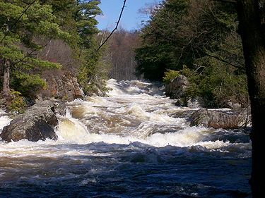
River
A river is a natural watercourse, usually freshwater, flowing towards an ocean, a lake, a sea, or another river. In a few cases, a river simply flows into the ground or dries up completely before reaching another body of water. Small rivers may also be called by several other names, including...
s in the U.S. state
U.S. state
A U.S. state is any one of the 50 federated states of the United States of America that share sovereignty with the federal government. Because of this shared sovereignty, an American is a citizen both of the federal entity and of his or her state of domicile. Four states use the official title of...
of New York
New York
New York is a state in the Northeastern region of the United States. It is the nation's third most populous state. New York is bordered by New Jersey and Pennsylvania to the south, and by Connecticut, Massachusetts and Vermont to the east...
.
By drainage basinDrainage basinA drainage basin is an extent or an area of land where surface water from rain and melting snow or ice converges to a single point, usually the exit of the basin, where the waters join another waterbody, such as a river, lake, reservoir, estuary, wetland, sea, or ocean...
This list is arranged by drainage basin, with respective tributaries indented by order of confluence with their main stem, from mouth to source.Long Island SoundLong Island SoundLong Island Sound is an estuary of the Atlantic Ocean, located in the United States between Connecticut to the north and Long Island, New York to the south. The mouth of the Connecticut River at Old Saybrook, Connecticut, empties into the sound. On its western end the sound is bounded by the Bronx...
(northern side)
- Housatonic River (CT)
- Tenmile River
- Swamp River
- Mill River
- Webatuck Creek
- Swamp River
- Green River
- Tenmile River
- Norwalk River (CT)
- Silvermine RiverSilvermine RiverThe Silvermine River is an river in Norwalk and New Canaan, Connecticut. It is spanned by the 1899 Perry Avenue Bridge in the Silvermine neighborhood, and by the Silvermine River Bridge that carries the Merritt Parkway. It is a tributary of the Norwalk River which it joins at the north end of...
- Silvermine River
- Rippowam RiverRippowam RiverThe Rippowam River is a river in Fairfield County, Connecticut. It drains a watershed area of and flows for from Ridgefield to Long Island Sound, which it enters in Stamford's harbor....
- Mill River
- Mianus RiverMianus RiverThe Mianus River is a river in Westchester County, New York and Fairfield County, Connecticut, in the United States. It begins in the town of North Castle, New York in a series of ponds at about altitude...
- Byram RiverByram RiverThe Byram River is a river approximately in length, in southeast New York and southwestern Connecticut in the United States.The river has an elevation of at its headwaters at Byram Lake in Westchester County, New York, and flows in a southward direction, crossing the New York-Connecticut border...
- Wampus River
- Mamaroneck River
- Sheldrake River
- Hutchinson River
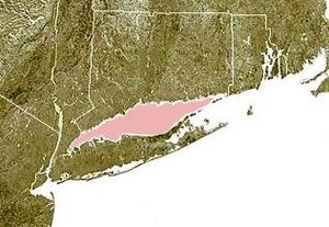
Long IslandLong IslandLong Island is an island located in the southeast part of the U.S. state of New York, just east of Manhattan. Stretching northeast into the Atlantic Ocean, Long Island contains four counties, two of which are boroughs of New York City , and two of which are mainly suburban...
Long Island Sound
- Nissequogue RiverNissequogue RiverThe Nissequogue River is an long river flowing from Smithtown, New York into the Long Island Sound.Its discharge of a second is the most of any of the freshwater rivers on Long Island....
- Wading River
Block Island Sound
- Peconic RiverPeconic RiverThe Peconic River is a river in Long Island's Suffolk County, New York in the United States. The river is located in the eastern end of Long Island...
- Little River
Atlantic Ocean
- Aspatuck River
- Speonk River
- Forge RiverForge River (New York)Forge River is a partially mixed estuary on the south shore of Long Island in the township of Brookhaven, Suffolk County, New York.-Course:Forge River is the major tributary of Moriches Bay, a part of Long Island’s south shore lagoonal system that is protected from the Atlantic Ocean by outer...
- Carmans RiverCarmans RiverThe Carmans River is a long river in Brookhaven in Suffolk County on Long Island.It is one of the four largest rivers on Long Island and is similar to other Long Island rivers in that is totally groundwater generated , although a lake did exist long ago. Almost all of the river is specifically...
- Swan RiverSwan River (New York)The Swan River flows south from Swan Lake into the mouth of Patchogue Bay, Long Island, New York, which then becomes the Great South Bay. Originally however, the headwaters reached as far north as Medford, New York near the vicinity of Medford Station. Swan River is a relatively clean, cold, free...
- Patchogue RiverPatchogue RiverThe Patchogue River is a mile-long waterway In Patchogue, New York that is lined with a variety restaurants, marinas, fueling docks, apartment condominiums, and ferry terminals.- Description :...
- Connetquot RiverConnetquot RiverThe Connetquot River is a long river in Islip. It is one of the four biggest rivers on Long Island and is recognized the state as a Wild, Scenic and Recreational River....
- Carlls River
- Massapequa Creek
- Cedar Swamp Creek
- Milburn Creek
- Mill River
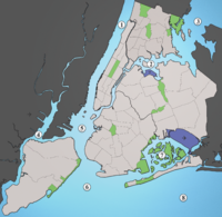
New York HarborNew York HarborNew York Harbor refers to the waterways of the estuary near the mouth of the Hudson River that empty into New York Bay. It is one of the largest natural harbors in the world. Although the U.S. Board of Geographic Names does not use the term, New York Harbor has important historical, governmental,...
- Arthur KillArthur KillThe Arthur Kill is a tidal strait separating Staten Island, New York from mainland New Jersey, USA, and a major navigational channel of the Port of New York and New Jersey. Kill is from the Middle Dutch word kille, meaning "riverbed" or "water channel"...
(tidal straitStraitA strait or straits is a narrow, typically navigable channel of water that connects two larger, navigable bodies of water. It most commonly refers to a channel of water that lies between two land masses, but it may also refer to a navigable channel through a body of water that is otherwise not...
)- Fresh KillsFresh KillsFresh Kills is a stream and freshwater estuary in the western portion of the New York City borough of Staten Island...
- Richmond CreekRichmond Creek (Fresh Kills)Richmond Creek is a stream in Staten Island, a borough of New York City in the United States. Its upper drainage basin includes the remote forested hills in the center of the island...
- Richmond Creek
- Fresh Kills
- Passaic RiverPassaic RiverThe Passaic River is a mature surface river, approximately 80 mi long, in northern New Jersey in the United States. The river in its upper course flows in a highly circuitous route, meandering through the swamp lowlands between the ridge hills of rural and suburban northern New Jersey,...
(NJ)- Saddle River
- Pompton RiverPompton RiverThe Pompton River is a tributary of the Passaic River, approximately 8 mi long, in northern New Jersey in the United States....
(NJ)- Pequannock RiverPequannock RiverThe Pequannock River is a tributary of the Pompton River, approximately 20 miles long, located in northern New Jersey in the United States....
(NJ)- Wanaque RiverWanaque RiverThe Wanaque River is a tributary of the Pequannock River in Passaic County in northern New Jersey in the United States....
- Ringwood River
- Wanaque River
- Ramapo RiverRamapo RiverThe Ramapo River is a tributary of the Pompton River, approximately 30 mi long, in southern New York and northern New Jersey in the United States.-Course:...
- Mahwah RiverMahwah RiverThe Mahwah River runs on a meandering SSW course for about 11 mi from its headwaters just north of the hamlet of Ladentown, New York to its mouth which empties into the Ramapo River in Mahwah, New Jersey, just south of the village of Suffern, New York, and the state line...
- Mahwah River
- Pequannock River
- Hackensack RiverHackensack RiverThe Hackensack River is a river, approximately 45 miles long, in the U.S. states of New York and New Jersey, emptying into Newark Bay, a back chamber of New York Harbor. The watershed of the river includes part of the suburban area outside New York City just west of the lower Hudson River,...
- Kill Van KullKill Van KullThe Kill Van Kull is a tidal strait between Staten Island, New York and Bayonne, New Jersey in the United States. Approximately long and wide, it connects Newark Bay with Upper New York Bay. The Robbins Reef Light marks the eastern end of the Kill, Bergen Point its western end...
(tidal strait) - East RiverEast RiverThe East River is a tidal strait in New York City. It connects Upper New York Bay on its south end to Long Island Sound on its north end. It separates Long Island from the island of Manhattan and the Bronx on the North American mainland...
(tidal strait)- Newtown CreekNewtown CreekNewtown Creek is a estuary that forms part of the border between the boroughs of Brooklyn and Queens, in New York City, New York, United States. It derives its name from New Town , which was the name for the Dutch and British settlement in what is now Elmhurst, Queens...
- Harlem RiverHarlem RiverThe Harlem River is a navigable tidal strait in New York City, USA that flows 8 miles between the Hudson River and the East River, separating the boroughs of Manhattan and the Bronx...
(tidal strait) - Bronx KillBronx KillThe Bronx Kill is a narrow strait in New York City delineating the southernmost extent of the Bronx and separating it from Randall's Island. It connects the Harlem River to the East River.-History:...
(tidal strait) - Bronx RiverBronx RiverThe Bronx River, approximately long, flows through southeast New York in the United States. It is named after colonial settler Jonas Bronck. The Bronx River is the only fresh water river in New York City....
- Flushing RiverFlushing RiverThe Flushing River, more properly and historically known as Flushing Creek, is a waterway that flows through the northern part of central Queens in New York City, emptying into the East River...
- Westchester CreekWestchester CreekWestchester Creek is a tidal inlet of the East River located in the south eastern portion of The Bronx in New York City. It is 2.1 miles in length...
- Newtown Creek
Hudson River Basin

- North RiverNorth River (New York-New Jersey)North River is an alternate name for the southernmost portion of the Hudson River in the vicinity of New York City and northeastern New Jersey. The colonial name for the entire Hudson given to it by the Dutch in the early seventeenth century, the term fell out of general use for most of the river's...
(lower Hudson River)- Hudson RiverHudson RiverThe Hudson is a river that flows from north to south through eastern New York. The highest official source is at Lake Tear of the Clouds, on the slopes of Mount Marcy in the Adirondack Mountains. The river itself officially begins in Henderson Lake in Newcomb, New York...
- Saw Mill RiverSaw Mill RiverThe Saw Mill River is a 20 mile long tributary of the Hudson River in the United States, flowing from a marsh in Chappaqua to Yonkers, New York, where it empties into the Hudson. Its starting point in Chappaqua is presumed to be a spring. In the 17th century, the Saw Mill River was known as...
- Wickers Creek
- Sparkill CreekSparkill CreekSparkill Creek, located in Rockland County, New York and Bergen County, New Jersey, is eight miles long and begins from rain on Clausland Mountain in Orangetown, New York...
- Pocantico River
- Sing Sing Brook
- Croton RiverCroton RiverThe Croton River is a river in southern New York that begins where the East and West Branches of the Croton River meet a little way downstream from the Croton Falls Reservoir...
- Kisco RiverKisco RiverThe Kisco River is a creek that runs through the Mount Kisco, New York area. It is formed by the forks of Chappaqua Brook and an unnamed stream...
- Muscoot River
- Cross RiverCross River (New York)The Cross River is a short river in southern New York State that rises near Cross River in the township of Lewisboro. After its rising point, it makes a loop, heading SE, then SW, then NW, and finally west. It flows a few miles in that direction until it ends up in the Cross River Reservoir, which...
- Stone Hill River
- Waccabuc River
- Titicus RiverTiticus RiverThe Titicus River is an 8.5 mile river in southwestern Connecticut and southeastern New York that drains in to the Titicus Reservoir, part of New York City's water supply system. The drainage area is . It is one of the few rivers in Connecticut that is part of the system. The source of the river is...
- East Branch Croton RiverEast Branch Croton RiverThe East Branch Croton River is a river in southern New York state.It rises in the town of Pawling in Dutchess County, flowing west and then south through the village of Pawling. It crosses into Putnam County, flowing through the Great Swamp in the town of Patterson...
- West Branch Croton River
- Kisco River
- Annsville Creek
- Peekskill Hollow CreekPeekskill Hollow CreekThe headwaters of Peekskill Hollow Creek originate as the outflow of Lake Tibet in the town of Carmel in Putnam County, New York. It flows in a south westerly direction for approximately before joining Sprout Creek and then Annsville Creek....
- Sprout Brook
- Canopus Creek
- Peekskill Hollow Creek
- Moodna CreekMoodna CreekMoodna Creek is a small tributary of the Hudson River that drains eastern Orange County, New York. At 15.5 miles in length from its source at the confluence of Cromline Creek and Otter Kill west of Washingtonville, it is the longest stream located entirely within the county.Despite its small...
- Silver Stream
- Woodbury Creek
- Mineral Spring Brook
- Cromline Creek
- Otter KillOtter KillOtter Kill is a tributary of Moodna Creek that flows through central Orange County, New York, in the United States. Via the Moodna, which it forms at a confluence with Cromline Creek north of the village of Washingtonville, its waters eventually reach the Hudson River.The Otter Kill flows...
- Black Meadow CreekBlack Meadow CreekBlack Meadow Creek is a tributary of the Otter Kill in Orange County, New York, in the United States. Via the Otter Kill, it is part of the Moodna Creek watershed, flowing onward to the Hudson River, in one of New York State's most biodiverse natural areas. Home to 13 species of salamander as well...
- Black Meadow Creek
- Fishkill CreekFishkill CreekFishkill Creek is a tributary of the Hudson River in Dutchess County, New York, United States. At it is the second longest stream in the county, after Wappinger Creek. It rises in the town of Union Vale and flows generally southwest to a small estuary on the Hudson just south of Beacon. Part of...
- Clove Creek
- Sprout CreekSprout CreekSprout Creek is a creek located entirely within Dutchess County, New York, United States. It is the largest tributary of Fishkill Creek, entering that creek some upstream from the Hudson River. The creek is annually stocked with 6,000 brown trout, and maintains its own natural population of...
- Jackson CreekJackson Creek (Sprout Creek)Jackson Creek is an tributary of Sprout Creek in Dutchess County, New York. Via Sprout Creek and Fishkill Creek, water from Jackson Creek flows to the Hudson River. Jackson Creek's subwatershed covers of land.-Course:...
- Jackson Creek
- Whortlekill Creek
- Quassaick CreekQuassaick CreekQuassaick Creek is an tributary of the Hudson River in Orange and Ulster counties in the U.S. state of New York. It rises in the glacial ridges west of the river, near the boundary between the towns of Plattekill and Marlborough...
- Wappinger CreekWappinger CreekWappinger Creek is a creek which runs from Thompson Pond to the Hudson River at New Hamburg in Dutchess County, New York, United States. It is the longest creek in Dutchess County, with the largest watershed in the county.- Overview :...
- Little Wappinger Creek
- CasperkillCasperkillThe Casperkill is a creek in both the town and city of Poughkeepsie, Dutchess County, New York. It flows from Peach Hill Park to the Hudson River...
- Crum Elbow Creek
- Saw Mill River
- Hudson River
-
-
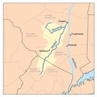
- Rondout CreekRondout CreekRondout Creek is a tributary of the Hudson River in Ulster and Sullivan counties, New York, USA. It rises on Rocky Mountain in the eastern Catskills, flows south into Rondout Reservoir, part of New York City's water supply network, then into the valley between the Catskills and the Shawangunk...
- Wallkill RiverWallkill RiverThe Wallkill River, a tributary of the Hudson, drains Lake Mohawk in Sparta, New Jersey, flowing from there generally northeasterly to Rondout Creek in New York, near Rosendale, with the combined flows reaching the Hudson at Kingston....
- Shawangunk KillShawangunk KillThe Shawangunk Kill is a stream that flows northward through Orange, Sullivan and Ulster counties, New York, in the United States. It is the largest tributary of the Wallkill River....
- Dwaar Kill (Shawangunk Kill)Dwaar Kill (Shawangunk Kill)The Dwaar Kill is a tributary of the Shawangunk Kill in Ulster County, New York, in the United States.The Dwaar Kill is born from Lake Awosting in Minnewaska State Park Preserve.-References:...
- Dwaar Kill (Shawangunk Kill)
- Dwaar Kill (Wallkill River)Dwaar Kill (Wallkill River)The Dwaar Kill is a tributary of the Wallkill River in Orange and Ulster counties in the U.S. state of New York. It is the Wallkill's second-longest tributary after the Shawangunk Kill, whose course it parallels somewhat to the east....
- Tin BrookTin BrookTin Brook is an tributary of the Wallkill River almost entirely located in the town of Montgomery in Orange County, New York, United States. Near its mouth it flows through the village of Walden...
- Muddy KillMuddy KillMuddy Kill is a tributary of the Wallkill River that runs entirely through the town of Montgomery in Orange County, New York, USA. It rises from a small pond just over a mile west of the village of Walden, flowing first southwesterly then roughly due south to empty into the Wallkill just upstream...
- Pochuck CreekPochuck CreekPochuck Creek is an tributary of the Wallkill River in Sussex County, New Jersey, in the United States.Pochuck Creek is called Wawayanda Creek above its confluence with the tributary Black Creek....
- Wawayanda CreekWawayanda CreekWawayanda Creek is the name of Pochuck Creek above its confluence with the tributary Black Creek. It is long. Wawayanda Creek, via Pochuck Creek, is a tributary of the Wallkill River in Sussex County, New Jersey in the United States....
- Wawayanda Creek
- Rutgers Creek
- Shawangunk Kill
- Wallkill River
- Saw Kill
- Stony Creek
- Esopus CreekEsopus CreekEsopus Creek is a tributary of the Hudson River that drains the east-central Catskill Mountains of the U.S. state of New York. From its source at Winnisook Lake on the slopes of Slide Mountain, the Catskills' highest peak, it flows across Ulster County to the Hudson at Saugerties. Many tributaries...
- Plattekill Creek
- Saw Kill (Esopus Creek)
- Beaver Kill
- Stony Clove CreekStony Clove CreekStony Clove Creek is a creek in the Catskill Mountains in New York. It is a tributary of Esopus Creek, which in turn is a tributary of the Hudson River. It joins the Esopus in the village of Phoenicia, and has two smaller tributaries up north of Phoenicia....
- Woodland Creek
- Sawyer KillSawyer KillThe Sawyer Kill or Sawyer's Kill is a tributary stream of the Hudson River in New York state. The source is at the Great Vlaie on the border of Ulster and Greene counties. The stream enters the Hudson River at Seamon Park in Malden, New York, just north of the village of Saugerties.Saugerties...
- Roeliff Jansen Kill
- Shekomeko Creek
- Bean River
- Bash Bish Brook
- Shekomeko Creek
- Catskill CreekCatskill CreekCatskill Creek is a tributary of the Hudson River that drains the east northern Catskill Mountains of the U.S. state of New York. From its source at Franklinton Vlaie in Schoharie County it flows southeast through parts of Albany County and Greene County to its mouth at the village of Catskill on...
- Kaaterskill CreekKaaterskill CreekKaaterskill Creek is a tributary of Catskill Creek in Greene and Ulster counties in New York. Via Catskill Creek, it is part of the Hudson River watershed....
- Potic CreekPotic CreekPotic Creek is a tributary to Catskill Creek in the Catskill Mountains of New York. The name comes from the Dutch for a "water fall", originally referring to the falls in the Cats Kill near Wolcott Mills. Potic also originally referred to the name of the American Indian village below the falls...
- Cob Creek
- Jan De Bakkers KillJan De Bakkers KillJan de Bakker's Kill is a stream in the Catskill Mountains of New York. It is a tributary of Catskill Creek, part of the Hudson River watershed. Its name derives from the Dutch and means "John the baker's creek".-References:...
- Basic CreekBasic Creek ReservoirThe Basic Creek Reservoir is one of three reservoirs in the City of Albany, New York's water system. The reservoir is located in Westerlo, New York and was constructed from 1928-1932 by damming the Basic Creek and flooding former farmland and forest...
- Bowery CreekBowery CreekBowery Creek is a tributary of Catskill Creek north of the Catskill Mountains of New York. Via Catskill Creek, it is part of the Hudson River watershed. Bowery Creek rises east of Windham High Peak in the northern part of the town of Cairo and flows northeast to Catskill Creek west of Freehold.The...
- Tenmile CreekTenmile Creek (Catskill Creek)Tenmile Creek is a tributary of Catskill Creek in Albany County, New York. Via Catskill Creek, it is part of the Hudson River watershed.Tenmile Creek runs through the villages of Rensselaerville and Medusa in the town of Rensselaerville. It approaches the village through a deep ravine, falling ...
- Eightmile CreekEightmile CreekEightmile Creek is an tributary of Tenmile Creek in Albany County, New York. Via Tenmile Creek and Catskill Creek, it is part of the Hudson River watershed. Eightmile Creek runs through the town of Westerlo into the town of Rensselaerville, where it joins Tenmile Creek at the hamlet of Medusa....
- Eightmile Creek
- Fox Creek
- Lake Creek
- Kaaterskill Creek
- Stockport CreekStockport CreekStockport Creek is a tributary to the Hudson River in the town of Stockport, New York, in the United States. Its source is the confluence of Kinderhook Creek and Claverack Creek near the village of Stockport. Its mouth is at the Hudson River at the western boundary of Stockport...
- Claverack CreekClaverack CreekClaverack Creek is a tributary to Stockport Creek in Columbia County, New York, in the United States. Its source is in the town of Claverack at the hamlet of Mellenville, and its mouth is at its confluence with Kinderhook Creek to form Stockport Creek, in the town of Stockport.-History:The lower...
- Taghkanic CreekTaghkanic CreekTaghkanic Creek is a tributary to Claverack Creek in Columbia County, New York, in the United States. Via Claverack Creek and Stockport Creek, it is part of the Hudson River watershed...
- Taghkanic Creek
- Kinderhook CreekKinderhook CreekKinderhook Creek is a tributary to Stockport Creek, an inlet of the Hudson River in the United States. From its source in Hancock, Massachusetts, the creek runs southwest through the Taconic Mountains into Rensselaer County, New York, and then into Columbia County...
- Valatie Kill
- Kline Kill
- Stony Kill
- Black River
- Claverack Creek
- Coxsackie CreekCoxsackie CreekCoxsackie Creek is a tributary to the Hudson River in the towns of Coxsackie and New Baltimore, New York, in the United States.- Tributaries :* Sickles Creek* Coxsackie Reservoir* Broncks Lake, in the hills above Bronck House...
- Mill Creek
- Hannacrois CreekHannacrois CreekHannacrois Creek is a tributary to the Hudson River in the U.S. state of New York. From its source in Westerlo it flows through Dunbar Hollows and over Dickinson Falls to the Alcove Reservoir...
- Coeymans CreekCoeymans CreekCoeymans Creek is a creek that runs though Albany County, New York. It is a tributary of the Hudson River. The creek originates as the continuation of Onesquethaw Creek, which starts near Clarksville, New York, in the Helderberg Mountains.-History:...
- Mosher Brook
- Onesquethaw CreekOnesquethaw CreekOnesquethaw Creek is a creek in Albany County, New York. It is a tributary of the Hudson River. It rises in the town of New Scotland, to the west of the hamlet of New Salem, in the Helderberg Mountains, and flows to Coeymans Creek in the town of Bethlehem, southwest of...
- Schodack Creek
- Muitzes Kill
- Vloman KillVloman KillThe Vloman Kill is an tributary to the Hudson River in Albany County, New York, in the United States. Its source is in the town of New Scotland near the village of Voorheesville, and its mouth is at the Hudson River near the hamlet of Cedar Hill, in the town of Bethlehem.The Normans Kill has a...
- Dowers Kill
- Phillipin Kill
- Moordener KillMoordener KillThe Moordener Kill is a tributary to the Hudson River that flows through southwestern Rensselaer County, New York, in the United States. Moordener Kill translates to "Murderer Creek", because the word moordener is the Dutch word for "murderer"...
- Normans KillNormans KillThe Normans Kill is a creek in New York's Capital District located in Schenectady and Albany counties, which flows southeasterly from its source in the town of Duanesburg near Delanson to its mouth at the Hudson River in the town of Bethlehem. The stream creates the Watervliet Reservoir in the...
- Bozen Kill
- Wynants KillWynants KillThe Wynants Kill is a stream which has its source at Glass Lake near Averill Park, New York, and terminates at the Hudson River at Troy, New York....
- Poesten KillPoesten KillThe Poesten Kill is a creek in upstate New York located entirely in Rensselaer County, which flows westerly from its source at Dyken Pond in the town of Berlin to its mouth at the Hudson River in the city of Troy...
- Quacken Kill
- Mohawk RiverMohawk RiverThe Mohawk River is a river in the U.S. state of New York. It is the largest tributary of the Hudson River. The Mohawk flows into the Hudson in the Capital District, a few miles north of the city of Albany. The river is named for the Mohawk Nation of the Iroquois Confederacy...
- Alplaus Kill
- Plotter KillPlotter Kill PreserveThe Almy D. Coggleshall Plotter Kill Preserve is a nature reserve and hiking area located on Route 159 in the town of Rotterdam, Schenectady County, New York State.-Etymology:...
- North Chuctanunda Creek
- South Chuctanunda Creek
- Schoharie CreekSchoharie CreekSchoharie Creek in New York, USA flows north from the foot of Indian Head Mountain in the Catskill Mountains through the Schoharie Valley to the Mohawk River. It is twice impounded north of Prattsville to create New York City's Schoharie Reservoir and the Blenheim-Gilboa Power Project.Two notable...
- Cobleskill Creek
- West Creek
- Fox CreekFox Creek (Schoharie Creek)Fox Creek is a tributary of Schoharie Creek in Schoharie and Albany counties in the U.S. state of New York. It rises in the southeastern part of the town of Berne, west of the Helderberg Mountains, and flows west, passing through the hamlets of East Berne, Bensons Corner, Berne, and West Berne,...
- Switz Kill
- Batavia Kill
- Little West Kill
- West Kill
- East Kill
- Cobleskill Creek
- Cayadutta Creek
- Canajoharie Creek
- Caroga Creek
- East Canada CreekEast Canada CreekEast Canada Creek is a river in upstate New York, USA. It is a tributary of the Mohawk River and flows southward from the Adirondack Park in that state. Part of the creek forms the boundary between Herkimer County and Fulton County and Montgomery County. It also flows through the Village of...
- Spruce Creek
- Sprite Creek
- Nowadaga Creek
- West Canada CreekWest Canada CreekWest Canada Creek is a river in upstate New York, USA. West Canada Creek drains the south part of the Adirondack Mountains and empties into the Mohawk River near the Village of Herkimer...
- Cold Brook
- Cincinnati Creek
- Black Creek
- South Branch West Canada Creek
- Indian River
- Fulmer Creek
- Steele Creek
- Moyer Creek
- Sauquoit Creek
- Oriskany CreekOriskany CreekOriskany Creek is a river in New York, USA. It rises in Madison County and flows northeastward, primarily through Oneida County. Oriskany Creek is a tributary of the Mohawk River and therefore part of the Hudson River watershed....
- Ninemile Creek
- Lansing Kill
- Hoosic RiverHoosic RiverThe Hoosic River, also known as the Hoosac, the Hoosick and the Hoosuck , is a tributary of the Hudson River in the northeastern United States. The different spellings are the result of varying transliterations of the river's original Algonquian name...
- Tomhannock Creek
- Owl Kill
- Walloomsac RiverWalloomsac RiverThe Walloomsac River from the Native American name, Wal-loom-sac is a tributary of the Hoosic River in the northeastern United States. It rises in southwestern Vermont, in the Green Mountains east of the town of Bennington in Woodford Hollow at the confluence of Bolles Brook and City Stream where...
- Little Hoosic River
- Fish Creek
- Kayaderosseras Creek
- Glowegee Creek
- Kayaderosseras Creek
- Batten KillBatten KillThe Batten Kill, or Battenkill, or the Battenkill River, is a river rising in Vermont that flows into New York and is a tributary of the Hudson River....
- Slocum Creek
- Moses Kill
- Dead Creek
- Snook Kill
- Champlain CanalChamplain CanalThe Champlain Canal is a canal that connects the south end of Lake Champlain to the Hudson River in New York. It was simultaneously constructed with the Erie Canal and is now part of the New York State Canal System and the Lakes to Locks Passage....
- Sturdevant Creek
- Sacandaga RiverSacandaga RiverThe Sacandaga River is a river in the northern part of New York in the United States. Its name comes from the Native American Sa-chen-da'-ga, meaning "overflowed lands"....
- Paul Creek
- Kennyetto Creek
- East Stony Creek
- West Stony Creek
- West Branch Sacandaga River
- Hamilton Lake Stream
- Piseco Outlet
- Fall Stream
- East Branch Sacandaga River
- Kunjamuk River
- Schroon RiverSchroon RiverThe Schroon River is a tributary of the Hudson River in the southern Adirondack Mountains of New York, beginning at the confluence of Crowfoot Brook and New Pond Brook near Underwood, and terminating at the Hudson in Warrensburg. Its watershed is entirely within the Adirondack Park...
- Trout Brook
- Minerva Stream
- The Branch
- Trout Brook
- Patterson Brook
- North Creek
- Boreas River
- Indian River
- Jessup River
- Miami RiverMiami River (New York)The Miami River is a stream in upstate New York and is a part of the Hudson River watershed. The river's headwaters rise in the Adirondack Mountains at about northwest of Speculator and flows southeast for about with Pillsbury Mountain on the southwest and Page Mountain to the northeast...
- Cedar RiverCedar River (New York)The Cedar River is a river in the central Adirondacks, in Hamilton County, New York. It rises at the outlet of the Cedar Lakes in the town of Arietta and flows northeast into the town of Lake Pleasant, where it passes through the Cedar River Flow...
- Rock River
- Goodnow River
- Newcomb River
- Opalescent River
- Rondout Creek
-
Delaware River Basin
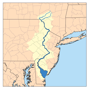
- Delaware RiverDelaware RiverThe Delaware River is a major river on the Atlantic coast of the United States.A Dutch expedition led by Henry Hudson in 1609 first mapped the river. The river was christened the South River in the New Netherland colony that followed, in contrast to the North River, as the Hudson River was then...
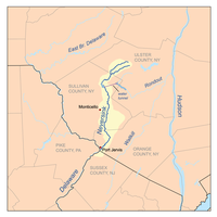
- Neversink RiverNeversink RiverThe Neversink River is a tributary of the Delaware River in southeastern New York in the United States...
- Basher Kill
- Sheldrake Stream
- East Branch Neversink River
- West Branch Neversink River
- Mongaup River
- Black Brook
- West Branch Mongaup River
- Middle Mongaup River
- East Mongaup River
- Neversink River
-
- Tenmile River
- Callicoon Creek
- East Branch Callicoon Creek
- North Branch Callicoon Creek
- East Branch Delaware RiverEast Branch Delaware RiverThe East Branch Delaware River, approximately 75 miles long in the U.S. state of New York, is one of two branches, along with the West Branch, that join to form the Delaware River. It flows through a mountainous area on the southwestern edge of the Catskill Park. For a long stretch it serves...
- Beaver Kill
- Willowemoc CreekWillowemoc CreekWillowemoc Creek is a tributary of Beaver Kill that is a popular trout fishing stream near the Catskill Park in Sullivan County, New York.- Course:...
- Little Beaver Kill
- Willowemoc Creek
- Tremper Kill
- Beaver Kill
- West Branch Delaware RiverWest Branch Delaware RiverThe West Branch Delaware River, approximately 90 mi long in the U.S. states of New York and Pennsylvania, is one of the two branches, along with the East Branch, that join to form the Delaware River...
- Little Delaware River
Susquehanna River Basin
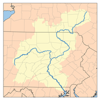
- Susquehanna RiverSusquehanna RiverThe Susquehanna River is a river located in the northeastern United States. At long, it is the longest river on the American east coast that drains into the Atlantic Ocean, and with its watershed it is the 16th largest river in the United States, and the longest river in the continental United...
- Chemung RiverChemung RiverThe Chemung River is a tributary of the Susquehanna River, approximately long, in south central New York and northern Pennsylvania in the United States. It drains a mountainous region of the northern Allegheny Plateau in the Southern Tier of New York...
- Baldwin Creek
- Bentley Creek
- Seeley Creek
- South Creek
- Mudlick Creek
- Newtown Creek
- Post Creek
- Cohocton RiverCohocton RiverThe Cohocton River is a tributary of the Chemung River in western New York in the United States. Via the Chemung River, it is part of the Susquehanna River watershed, flowing to Chesapeake Bay...
- Meads Creek
- Mud Creek
- Campbell Creek
- Fivemile Creek
- Goff Creek
- Tioga RiverTioga River (Chemung River)The Tioga River is a tributary of the Chemung River, approximately long, in northern Pennsylvania and western New York in the United States...
- Canisteo RiverCanisteo RiverThe Canisteo River is a tributary of the Tioga River in western New York in the United States. It drains a dissected plateau, a portion of the northern Allegheny Plateau southwest of the Finger Lakes region, in the far northwestern reaches of the watershed of the Susquehanna River.It rises in the...
- Tuscarora Creek
- North Branch Tuscarora Creek
- Colonel Bills Creek
- Bennetts Creek
- Purdy Creek
- Crosby Creek
- Canacadea Creek
- Tuscarora Creek
- Cowanesque RiverCowanesque RiverThe Cowanesque River is a tributary of the Tioga River in Potter and Tioga counties, Pennsylvania, and Steuben County, New York, in the United States....
- Troups CreekTroups CreekTroups Creek is a tributary of the Cowanesque River in Steuben County, New York and Tioga County, Pennsylvania in the United States.Troups Creek is born in New York and flows southeast, joining the Cowanesque River at the borough of Knoxville, Pennsylvania....
- North Fork Cowanesque River
- Troups Creek
- Canisteo River
- Cayuta CreekCayuta CreekCayuta Creek is a tributary of the Susquehanna River that flows through Schuyler, Chemung and Tioga counties in New York state, and Bradford County, Pennsylvania....
- Wappasening CreekWappasening CreekWappasening Creek is a tributary of the Susquehanna River in New York and Pennsylvania in the United States.Wappasening Creek flows out of Bradford County, Pennsylvania into New York to join the Susquehanna approximately above the borough of Sayre, Pennsylvania.-References:*Gertler, Edward....
- Pipe Creek
- Owego Creek
- Catatonk Creek
- Willseyville Creek
- East Branch Owego Creek
- West Branch Owego Creek
- Catatonk Creek
- Apalachin Creek
- Nanticoke Creek
- Choconut Creek
- Chenango RiverChenango RiverThe Chenango River is a tributary of the Susquehanna River in central New York in the United States. It drains a dissected plateau area in upstate New York at the northern end of the Susquehanna watershed....
- Page Brook
- Tioughnioga RiverTioughnioga RiverThe Tioughnioga River is a tributary of the Chenango River in central New York in the United States. It drains a dissected plateau area east of the Finger Lakes at the northernmost edge of the watershed of the Susquehanna River....
- Otselic RiverOtselic RiverThe Otselic River is a tributary of the Tioughnioga River in central New York in the United States. It drains a mountainous area, mostly forested and agricultural, east of the Finger Lakes at the northern edge of the Susquehanna River watershed....
- Merrill Creek
- Mud Creek
- Dudley Creek
- Hunts Creek
- East Branch Tioughnioga River
- West Branch Tioughnioga River
- Otselic River
- Genegantslet Creek
- Bowman Creek
- Mill Brook
- Canasawacta Creek
- Sangerfield River
- Little Snake Creek
- Snake Creek
- Wylie Brook
- Unadilla RiverUnadilla RiverThe Unadilla River in New York State flows from south of Utica to the village of Sidney, where it flows into the Susquehanna River, which eventually empties into the Chesapeake Bay, an arm of the Atlantic Ocean....
- Butternut Creek
- Wharton Creek
- Beaver Creek
- Ouleout Creek
- Treadwell Creek
- Otego CreekOtego CreekOtego Creek is a tributary of the Susquehanna River in central New York, USA.Otego Creek rises in the town of Otsego and flows south through Hartwick and Laurens, joining the Susquehanna in the western part of the city of Oneonta in the southernmost part of Otsego County....
- Charlotte Creek
- Schenevus Creek
- Cherry Valley CreekCherry Valley CreekCherry Valley Creek is a tributary of the Susquehanna River in central New York, USA.Cherry Valley Creek flows southwesterly through the Cherry Valley in Otsego County, through the towns of Cherry Valley, Roseboom, Middlefield, and Milford....
- Oaks Creek
- Chemung River
Lake ChamplainLake ChamplainLake Champlain is a natural, freshwater lake in North America, located mainly within the borders of the United States but partially situated across the Canada—United States border in the Canadian province of Quebec.The New York portion of the Champlain Valley includes the eastern portions of...
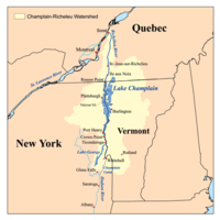
- Great Chazy RiverChazy RiverChazy River is the name of two tributaries of Lake Champlain in Clinton County, New York in the United States.The more northerly river is the Great Chazy River, which empties into Lake Champlain at King Bay in the Town of Champlain....
- Beaver Creek
- North Branch Great Chazy River
- Little Chazy RiverChazy RiverChazy River is the name of two tributaries of Lake Champlain in Clinton County, New York in the United States.The more northerly river is the Great Chazy River, which empties into Lake Champlain at King Bay in the Town of Champlain....
- Saranac RiverSaranac RiverSaranac River is an river in the U.S. state of New York. In its upper reaches is a region of mostly flat water and lakes. The river has more than three dozen source lakes and ponds north of Upper Saranac Lake; the highest is Mountain Pond on Long Pond Mountain...
- North Branch Saranac River
- Salmon River
- Little Ausable RiverLittle AuSable RiverThe Little AuSable river is a spring-fed stream originating in Huron County, Ontario. It is the only stream of any size running through the township of Lucan Biddulph, a municipality whose watershed feeds the Little AuSable with pasture and field runoff...
- Ausable River
- East Branch Ausable River
- West Branch Ausable River
- Black Brook
- Chubb River
- Boquet River
- North Branch Boquet River
- Black River
- La Chute
- Northwest Bay Brook
- East Bay
- Poultney RiverPoultney RiverThe Poultney River goes through Vermont and New York, and ends in Lake Champlain....
- Poultney River
- Mettawee RiverMettawee RiverMettawee River is a river in western Vermont and eastern New York in the United States, passing the town of Granville, New York. The river is particularly good for rapids and kayaking. It ends in Lake Champlain....
- Wood Creek (Champlain Canal)
- Halfway Creek
- Big Creek
- Indian River
- Wood Creek (Champlain Canal)

St. Lawrence River
- Saint Lawrence RiverSaint Lawrence RiverThe Saint Lawrence is a large river flowing approximately from southwest to northeast in the middle latitudes of North America, connecting the Great Lakes with the Atlantic Ocean. It is the primary drainage conveyor of the Great Lakes Basin...
- English River
- Chateauguay RiverChateauguay RiverThe Chateauguay River has its source in northern New York State in the United States. It winds its way through several towns and villages in Quebec, Canada, such as Huntingdon, Dewittville, Ormstown and Châteauguay before emptying into the Saint Lawrence River near Montreal.The river is home to...
- Marble River
- Trout River
- Little Trout River
- Salmon River
- Pike Creek
- Little Salmon River
- Farrington Brook
- St. Regis RiverSt. Regis RiverThe St. Regis River is an river in northern New York in the USA. It flows into the Saint Lawrence River at the hamlet of St Regis in the St. Regis Mohawk Reservation. The Saint Regis River basin includes Upper and Lower St. Regis Lakes, and Saint Regis Pond in the Saint Regis Canoe Area.-External...
- Deer River
- Trout Brook (Deer River)
- West Branch Deer River
- West Branch St. Regis River
- Trout Brook (St. Regis River)
- Stony Brook
- Long Pond Outlet
- Windfall Brook
- Lake Ozonia Outlet
- East Branch St. Regis River
- Osgood River
- Onion River
- Deer River
-
- Raquette RiverRaquette RiverThe Raquette River, sometimes spelled Racquette, originates at Raquette Lake in the Adirondack Mountains in New York. long, it is the third longest river entirely in the state of New York....
- Plum Brook
- Trout Brook (Raquette River)
- Jordan River
- Bog RiverBog RiverThe Bog River, also called the Bog River Flow is a river that originates near the sources of the Oswegatchie River, in Hamilton County, New York in the Adirondacks, and flows through Lows Lake and Hitchens Pond, ending at the Bog River Falls at the entrance to Tupper Lake. For much of its...
- Round Lake Stream
- Ampersand Brook
- Moose Creek
- Cold RiverCold River (New York)The Cold River is a river in the Adirondack Mountains in New York, United States. It was one of the first rivers in the state designated as a Wild River, in 1972...
- Big Brook
- Salmon River
- Marion RiverMarion RiverThe Marion River is a river that connects Blue Mountain Lake via Utowana Lake and Eagle Lake to Raquette Lake in Hamilton County in the central Adirondacks. New York State has classified the Marion as a Scenic River....
- South Inlet
- Grass RiverGrasse RiverThe Grasse River or Grass River is a river in northern New York, in the United States...
- Little River
- Harrison Creek
- Tanner Creek
- North Branch Grass River
- Middle Branch Grass River
- South Branch Grass River
- Brandy Brook
- Sucker Brook
- Oswegatchie RiverOswegatchie RiverThe Oswegatchie River is a river in northern New York that flows north from the Adirondack Mountains to the Saint Lawrence River at the city of Ogdensburg. The river mouth was the site of a Jesuit mission, Fort de La Présentation, founded in 1749. Also a fur trading post, the village had 3,000...
- Indian River
- Black Creek
- Otter Creek
- West Creek
- Bonaparte Creek
- Indian Creek
- West Branch Oswegatchie River
- Big Creek
- Middle Branch Oswegatchie River
- Palmer Creek
- Little River
- Robinson River
- Indian River
- Chippewa Creek
- Crooked Creek
- Cranberry Creek
- Mullet Creek
- French Creek
- Raquette River
Lake OntarioLake OntarioLake Ontario is one of the five Great Lakes of North America. It is bounded on the north and southwest by the Canadian province of Ontario, and on the south by the American state of New York. Ontario, Canada's most populous province, was named for the lake. In the Wyandot language, ontarío means...
- Chaumont River
- Perch River
- Black RiverBlack River (New York)The Black River is a blackwater river that empties into the eastern end of Lake Ontario on the shore of Jefferson County, New York in the United States of America...
- Deer River
- West Branch Deer River
- Beaver RiverBeaver River (New York)The Beaver River is a small mountain stream which flows from the Adirondack Mountains to the Black River at Naumberg, north of Lowville in northwestern New York. The Beaver flows through parts of Hamilton, Herkimer, and Lewis counties...
- Black Creek
- Crystal CreekCrystal CreekCrystal Creek is a picturesque creek that runs for 17.5 km, beginning just below Paluma, Queensland, flowing through the township of Mutarnee and emptying into the Coral Sea...
- Independence RiverIndependence RiverThe Independence River is a small but beautiful mountain stream which originates near the western edge of Adirondack Park. It begins in Herkimer County and flows west into Lewis County, toward its confluence with the Black River in Watson, north of Lyons Falls and just south of Lowville....
- Roaring Brook
- Otter Creek
- Moose RiverMoose River (New York)The Moose River is a mountain waterway which consists of three branches: the North Branch, the Middle Branch and the South Branch. The outlet of Big Moose Lake forms the North Branch in northern Herkimer County. The Middle Branch originates at the Fulton Chain Lakes in Old Forge. And the Southern...
- Pine Creek
- Middle Branch Moose River
- North Branch Moose River
- South Branch Moose River
- Red River
- Indian RiverIndian River (Moose River)The Indian River of the Moose River Plains is one of many rivers of the same name. This particular river starts in Brook Trout Lake in the Plains of the southwest Adirondack Mountains. Traveling downstream, it picks up the Cobblestone Creek coming in on its left, just before it forms the Green...
- Cobblestone Creek
- Otter Brook
- Sugar River
- Moose Creek
- White River
- Woodhull Creek
- Little Woodhull Creek
- Little Black Creek
- Deer River
- Mill Creek
- Stony Creek
- Sandy Creek (Jefferson County, New York)
- South Sandy Creek
- Abijah Creek
- Grunley Creek
- North Branch Sandy Creek
- Gulf Stream
- South Sandy Creek
- Little Sandy Creek
- Salmon RiverSalmon River (New York)The Salmon River arises in north central New York State on the Tug Hill Plateau to the east of Lake Ontario. It flows westward off the plateau and there is a hydroelectric dam near Little America to create the Salmon River Reservoir. Both the Salmon River and Salmon River Reservoir are heavily...
- North Branch Salmon River
- Mad River
- North Branch Salmon River
- Little Salmon River
- North Branch Little Salmon River
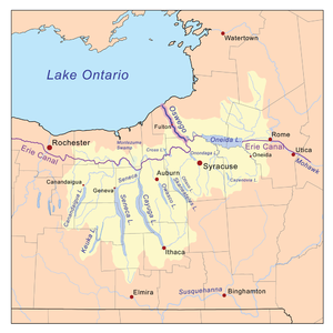
- Oswego RiverOswego River (New York)The Oswego River is a river in upstate New York in the United States. This river is the second-largest river flowing into Lake Ontario. James Fenimore Cooper’s novel The Pathfinder, or The Inland Sea is set in the Oswego River valley...
- Oneida RiverOneida RiverThe Oneida River in central New York state flows from Oneida Lake to its confluence with the Seneca and Oswego rivers. The Oswego empties the water of the other two rivers into Lake Ontario....
- Caughdenoy Creek
- Oneida Lake:
- Scriba Creek
- Chittenango CreekChittenango CreekChittenango Creek is a small river in central New York, USA. Chittenango Creek flows northward through Chittenango into Oneida Lake near the community of Bridgeport and partially forms the boundary between Onondaga County and Madison County...
- Limestone Creek
- Butternut Creek
- Limestone Creek
- Oneida CreekOneida CreekOneida Creek is a small river in New York in the USA. The creek enters Oneida Lake at its southeast corner at a location known as South Bay, a bay of the lake...
- Fish Creek
- Wood Creek
- East Branch Fish Creek
- Point Rock Creek
- West Branch Fish Creek
- Little River (Fish Creek)
- Mad River
- Little River (Mad River)
- Seneca RiverSeneca River (New York)The Seneca River in central New York flows from west to east, from Seneca Lake, through the Montezuma Marsh at the north end of Cayuga Lake to the Seneca's confluence with the Oneida and Oswego rivers at the Three Rivers area north of Syracuse. Much of the river has been channelized to form part...
- Onondaga Lake:
- Ninemile CreekNinemile Creek (Onondaga Lake)Nine Mile Creek, a scenic stream noted for trout fishing, extends about twenty-five miles from Otisco Lake in the Town of Marcellus, New York. The Creek runs northward through the villages of Marcellus, New York and Camillus, New York in the Town of Camillus, New York, and discharges into Onondaga...
- Ley Creek
- Onondaga CreekOnondaga CreekOnondaga Creek is a major tributary of Onondaga Lake which is located in Onondaga County, New York. The headwaters of the creek originate south of the city of Syracuse near the hamlet of Vesper, New York...
- Ninemile Creek
- Skaneateles CreekSkaneateles CreekSkaneateles Creek is a river in New York, the United States. It drains Skaneateles Lake to the Seneca River. It flows through Skaneateles, Skaneateles Falls, Mottville, Elbridge, and Jordan before joining the Seneca River, about 2 miles northwest of Jordan, New York.The Erie Canal crossed over...
- Owasco OutletOwasco RiverOwasco River is a river in Cayuga County, New York, United States. The Owasco River Railway is named after the river.It begins at Owasco Lake and flows north-northwest to the Seneca River....
- Clyde River
- Canandaigua Outlet
- Flint CreekFlint Creek (New York)Flint Creek is a creek in the Finger Lakes Region of New York State, located between Canandaigua and Seneca Lake. Flint Creek is part of the Canandaigua Lake watershed which is part of the Oswego River drainage basin, which drains in Lake Ontario...
- Canandaigua Lake:
- West River
- Flint Creek
- Ganargua Creek
- Mud Creek
- Canandaigua Outlet
- Cayuga Lake:
- Trumansburg Creek
- Taughannock CreekTaughannock Falls State ParkTaughannock Falls State Park is located in the Town of Ulysses in Tompkins County, New York, in the United States. The park is northwest of Ithaca near Trumansburg, New York...
- Salmon Creek
- Fall Creek
- Virgil Creek
- Cayuga Inlet
- Sixmile Creek
- Seneca Lake:
- Keuka Lake Outlet
- Catherine CreekCatherine Creek (New York)Catharine Creek is a roughly 15 mile long stream that flows through Chemung and Schuyler counties in New York state. It was named after Catharine Montour....
- Onondaga Lake:
- Oneida River
- Ninemile Creek
- Sterling Creek
- Irondequoit CreekIrondequoit CreekIrondequoit Creek is a stream in eastern Monroe County, New York that feeds Irondequoit Bay. It actually begins in rural West Bloomfield in Ontario County, flowing north into the town of Mendon in Monroe County...
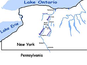
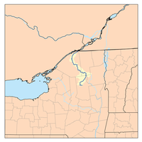
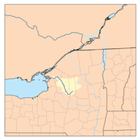
- Genesee RiverGenesee RiverThe Genesee River is a North American river flowing northward through the Twin Tiers of Pennsylvania and New York. The river provided the original power for the Rochester area's 19th century mills and still provides hydroelectric power for downtown Rochester....
- Black Creek (Genesee River-Monroe County, New York)
- Oatka CreekOatka CreekOatka Creek is the third longest tributary of the Genesee River, located entirely in the Western New York region of the U.S. state of New York. From southern Wyoming County, it flows to the Genesee near Scottsville, draining an area of that includes all or part of 23 towns and villages in...
- Honeoye CreekHoneoye CreekHoneoye Creek is a tributary of the Genesee River in western New York in the United States.Honeoye Creek emerges from the north end of Honeoye Lake, one of the Finger Lakes, in Richmond, Ontario County...
- Canaseraga Creek
- Wiscoy CreekWiscoy CreekWiscoy Creek is a stream, approximately 15 miles long, in western New York in the United States. It is a tributary of the Genesee River and joins that river in the town of Hume in northern Allegany County. The Wiscoy originates from two branches in Wyoming County. The North Branch begins in the...
- Rush Creek
- Cold Creek
- Caneadea Creek
- Black Creek (Genesee River-Allegany County, New York)
- Angelica CreekAngelica CreekAngelica Creek is a tributary of the Schuylkill River in Berks County, Pennsylvania in the United States.Angelica Creek joins the Schuylkill River at Kenhorst.-References:*Gertler, Edward. Keystone Canoeing, Seneca Press, 2004. ISBN 0-9749692-0-6...
- Baker Creek
- Black Creek (Angelica Creek)
- Van Campen Creek
- Vandermark Creek
- Dyke Creek
- Chenunda Creek
- Cryder Creek
- Salmon Creek
- Otis Creek
- Sandy Creek (Monroe County, New York)
- Oak Orchard Creek
- Johnson Creek
- Eighteen Mile CreekEighteen Mile Creek (Niagara County)Eighteen Mile Creek in Niagara County, New York, USA, is a tributary of Lake Ontario and is located entirely in Niagara County. The name "Eighteen Mile" creek refers not to the length of the creek, but to its distance from the Niagara River to the west....
- Niagara RiverNiagara RiverThe Niagara River flows north from Lake Erie to Lake Ontario. It forms part of the border between the Province of Ontario in Canada and New York State in the United States. There are differing theories as to the origin of the name of the river...
- Tonawanda CreekTonawanda CreekTonawanda Creek is a small river in Western New York, in the United States. William Bright says the best that can be said of the name is that it is "probably from an Iroquoian source, but of unclear derivation".-Description:...
- Ellicott CreekEllicott CreekEllicott Creek is a stream in Western New York, United States. It is a tributary of Tonawanda Creek, which in turn into the Niagara River.-Course:...
- Ellicott Creek
- Scajaquada CreekScajaquada CreekScajaquada Creek is a stream located in Erie County, New York, USA. The name is derived from Philip Kenjockety, an Indian described as the oldest resident of the region upon his death in 1808....
- Tonawanda Creek
Lake ErieLake ErieLake Erie is the fourth largest lake of the five Great Lakes in North America, and the tenth largest globally. It is the southernmost, shallowest, and smallest by volume of the Great Lakes and therefore also has the shortest average water residence time. It is bounded on the north by the...
- Buffalo RiverBuffalo River (New York)The Buffalo River is a river that empties into the eastern end of Lake Erie, one of the Great Lakes, by the City of Buffalo in the United States of America. This stream is called the Buffalo River only in the vicinity of the city and is known as Buffalo Creek as it flows through other parts of...
- Cazenovia CreekCazenovia CreekCazenovia Creek is a small stream in Western New York, United States. The creek is named after Theophilus Cazenove, an agent of the Holland Land Company. Cazenovia Creek is a tributary of the Buffalo River, which empties into Lake Erie...
- East Branch Cazenovia Creek
- West Branch Cazenovia Creek
- Cayuga CreekCayuga CreekCayuga Creek is a small stream in western New York, USA. The creek enters Buffalo Creek in the northwest corner of the Town of West Seneca just upstream from the New York State Thruway crossing...
- Buffalo CreekBuffalo River (New York)The Buffalo River is a river that empties into the eastern end of Lake Erie, one of the Great Lakes, by the City of Buffalo in the United States of America. This stream is called the Buffalo River only in the vicinity of the city and is known as Buffalo Creek as it flows through other parts of...
- Hunters Creek
- Cazenovia Creek
- Eighteen Mile CreekEighteen Mile Creek (Erie County)Eighteen Mile Creek, Erie County, New York, USA, flows into Lake Erie in the south part of Erie County. The name is derived from the distance south of the Niagara River in Buffalo....
- South Branch Eighteenmile Creek
- Cattaraugus CreekCattaraugus CreekCattaraugus Creek is a stream, approximately 68 miles long, in western New York in the United States. The creek drains a wooded rural portion of western New York southwest of Buffalo into Lake Erie. In its lower course it flows primarily through the Cattaraugus Reservation of the Seneca tribe...
- South Branch Cattaraugus Creek
- Mansfield Creek
- Buttermilk Creek
- South Branch Cattaraugus Creek
- Canadaway Creek
- Chautauqua CreekChautauqua CreekChautauqua Creek is a tributary of Lake Erie, approximately long, in the southwestern corner of New York in the United States. The headwaters of the creek rise in the town of Sherman, in Chautauqua County, and flow in a northerly direction through the town and village of Westfield where they empty...
- Twentymile CreekTwentymile CreekTwentymile Creek is a tributary of Lake Erie in Chautauqua County, New York and Erie County, Pennsylvania in the United States.Twentymile Creek joins Lake Erie near the community of Orchard Beach, Pennsylvania....
Mississippi River Basin
- Mississippi River
- Ohio River
- Allegheny RiverAllegheny RiverThe Allegheny River is a principal tributary of the Ohio River; it is located in the Eastern United States. The Allegheny River joins with the Monongahela River to form the Ohio River at the "Point" of Point State Park in Downtown Pittsburgh, Pennsylvania...
- French CreekFrench Creek (Allegheny River)French Creek is a tributary of the Allegheny River in northwestern Pennsylvania and western New York in the United States.- Etymology :...
- Brokenstraw CreekBrokenstraw CreekBrokenstraw Creek is a tributary of the Allegheny River in Warren County, Pennsylvania in the United States.Brokenstraw Creek joins the Allegheny River downstream of the city of Warren.-External links:*...
- Conewango CreekConewango CreekConewango Creek is a tributary of the Allegheny River in Pennsylvania and western New York in the United States.The creek's drainage covers much of southeastern Chautauqua County, New York and southwestern Cattaraugus County, New York. The creek's most notable tributary is the Chadakoin River,...
- Stillwater Creek
- Cassadaga Creek
- Chadakoin River
- Red House Brook
- Little Valley CreekLittle Valley (town), New YorkLittle Valley is a town in Cattaraugus County, New York, United States. The population was 1,788 at the 2000 census. The town is named after its local geographical setting, a relative comparison of two tributaries of the Allegheny River.The Town of Little Valley is centrally located in the county...
- Great Valley CreekGreat Valley, New YorkGreat Valley is a town in Cattaraugus County, New York, United States. The population was 2,145 at the 2000 census. The town is named after its local geographical setting, a relative comparison of two tributaries of the Allegheny River.The Town of Great Valley is centrally located in the...
- Wrights Creek
- Forks Creek
- Beaver Meadows Creek
- Devereaux Branch
- Tunungwant Creek
- Olean Creek
- Ischua Creek
- Gates Creek
- Oil Creek
- Ischua Creek
- Haskell Creek
- Dodge Creek
- Oswayo Creek
- Little Genesee Creek
- French Creek
- Allegheny River
- Ohio River