
List of New Hampshire rivers
Encyclopedia
This is a list of rivers and significant streams in the U.S. state
of New Hampshire
.
All watercourses named "River" (freshwater or tidal) are listed here, as well as other streams which are either subject to the New Hampshire Comprehensive Shoreland Protection Act or are more than 10 miles (16.1 km) long. New Hampshire rivers and streams qualify for state shoreland protection (and are listed here in bold) if they are fourth-order or larger water bodies, based on the Strahler
method of stream order classification.
. The list is sorted by major drainage basin
, running from north to south along the Atlantic coast, with respective tributaries arranged based on their entry into the main stream from mouth to source. Where several tributaries enter a single lake, they are listed running clockwise from the lake outlet.

U.S. state
A U.S. state is any one of the 50 federated states of the United States of America that share sovereignty with the federal government. Because of this shared sovereignty, an American is a citizen both of the federal entity and of his or her state of domicile. Four states use the official title of...
of New Hampshire
New Hampshire
New Hampshire is a state in the New England region of the northeastern United States of America. The state was named after the southern English county of Hampshire. It is bordered by Massachusetts to the south, Vermont to the west, Maine and the Atlantic Ocean to the east, and the Canadian...
.
All watercourses named "River" (freshwater or tidal) are listed here, as well as other streams which are either subject to the New Hampshire Comprehensive Shoreland Protection Act or are more than 10 miles (16.1 km) long. New Hampshire rivers and streams qualify for state shoreland protection (and are listed here in bold) if they are fourth-order or larger water bodies, based on the Strahler
Strahler Stream Order
In mathematics, the Strahler number or Horton–Strahler number of a mathematical tree is a numerical measure of its branching complexity....
method of stream order classification.
Alphabetically
- Ammonoosuc RiverAmmonoosuc RiverThe Ammonoosuc River is a river, 55 mi long, in northwestern New Hampshire in the United States. It is a tributary of the Connecticut River, which flows to Long Island Sound. "Ammonoosuc" is Abnaki for "small, narrow fishing place"....
- Androscoggin RiverAndroscoggin RiverThe Androscoggin River is a river in the U.S. states of Maine and New Hampshire, in northern New England. It is long and joins the Kennebec River at Merrymeeting Bay in Maine before its water empties into the Gulf of Maine on the Atlantic Ocean. Its drainage basin is in area...
- Ashuelot RiverAshuelot RiverThe Ashuelot River is a tributary of the Connecticut River, approximately long, in southwestern New Hampshire in the United States. It drains a mountainous area of , including much of the area known as the Monadnock Region...
- Baboosic BrookBaboosic BrookBaboosic Brook is a stream located in southern New Hampshire in the United States. It is a tributary of the Souhegan River, which flows to the Merrimack River and ultimately to the Gulf of Maine....
- Back RiverBack River (Powwow River)The Back River is a river located in New Hampshire and Massachusetts in the United States. It is a tributary of the Powwow River, part of the Merrimack River watershed. Approximately of the river are in New Hampshire, with the remaining in Massachusetts....
- Baker RiverBaker River (New Hampshire)The Baker River, or Asquamchumauke, is a river in the White Mountains region of New Hampshire, the United States. It rises on the south side of Mount Moosilauke and runs south and east to empty into the Pemigewasset River in Plymouth. The river traverses the towns of Warren, Wentworth, and...
- Bean RiverBean RiverThe Bean River is a 7.4 mile long river located in southeastern New Hampshire in the United States. It is a tributary of the North River, part of the Lamprey River/Great Bay/Piscataqua River watershed leading to the Atlantic Ocean....
- Bear BrookBear Brook (Suncook River)Bear Brook is a stream located in central New Hampshire in the United States. It is a tributary of the Suncook River, part of the Merrimack River watershed. Its entire course is within Bear Brook State Park....
- Bearcamp RiverBearcamp RiverThe Bearcamp River is a 26.3 mile long river at the southern edge of the White Mountains in New Hampshire, the United States. It is the largest tributary of Ossipee Lake, part of the Saco River watershed leading to the Atlantic Ocean....
- Beards BrookBeards BrookBeards Brook or Beard Brook is a stream located in southern New Hampshire in the United States. It is a tributary of the North Branch of the Contoocook River, part of the Merrimack River watershed....
- Beaver BrookBeaver Brook (Merrimack River)Beaver Brook is a river located in New Hampshire and Massachusetts in the United States. It is a tributary of the Merrimack River, part of the Gulf of Maine watershed....
- Beebe RiverBeebe RiverThe Beebe River is a river located in the White Mountains of New Hampshire in the United States. It is a tributary of the Pemigewasset River, part of the Merrimack River watershed....
- Beech RiverBeech River (New Hampshire)The Beech River is a 13.1 mile long river located in eastern New Hampshire in the United States. It is a tributary of the Pine River, part of the Ossipee Lake / Saco River watershed leading to the Atlantic Ocean....
- Bellamy RiverBellamy RiverThe Bellamy River, in Strafford County, southeastern New Hampshire, is a tributary of the Piscataqua River about long. It rises in Swains Lake in Barrington, west of Dover...
- Berrys RiverBerrys RiverThe Berrys River is a 12.9 mile long river located in southeastern New Hampshire in the United States. It is a tributary of the Isinglass River, part of the Cocheco River/Piscataqua River watershed leading to the Atlantic Ocean....
- Big RiverBig River (New Hampshire)The Big River is a river located in central New Hampshire in the United States. It is a tributary of the Suncook River, part of the Merrimack River watershed....
- Black BrookBlack Brook (Merrimack River)Black Brook is an stream located in southern New Hampshire in the United States. It is a tributary of the Merrimack River, which flows to the Gulf of Maine....
- Blackwater River (Contoocook River)Blackwater River (Contoocook River)The Blackwater River is a river located in central New Hampshire in the United States. It is a tributary of the Contoocook River, part of the Merrimack River watershed....
- Blackwater River (Massachusetts-New Hampshire)
- Blow-me-down BrookBlow-me-down BrookBlow-me-down Brook is a 12.8 mile long stream located in western New Hampshire in the United States. It is a tributary of the Connecticut River, which flows to Long Island Sound....
- Branch RiverBranch River (New Hampshire)The Branch River is an 11.9 mile long river located in eastern New Hampshire in the United States. It is a tributary of the Salmon Falls River, part of the Piscataqua River watershed leading to the Atlantic Ocean....
- Browns River
- Chickwolnepy StreamChickwolnepy StreamChickwolnepy Stream is a 14.2 mile long river in northern New Hampshire in the United States. It is a tributary of the Androscoggin River, which flows south and east into Maine, joining the Kennebec River near the Atlantic Ocean....
- Clear StreamClear StreamClear Stream is an 11.8 mile long river in northern New Hampshire in the United States. It is a tributary of the Androscoggin River, which flows south and east into Maine, joining the Kennebec River near the Atlantic Ocean....
- Chocorua RiverChocorua RiverThe Chocorua River is a river located in eastern New Hampshire in the United States. It is a tributary of the Bearcamp River, part of the Ossipee Lake / Saco River watershed leading to the Atlantic Ocean....
- Cocheco River
- Cockermouth RiverCockermouth RiverThe Cockermouth River is a stream located in central New Hampshire in the United States. It is the longest tributary of Newfound Lake, part of the Pemigewasset River and ultimately Merrimack River watersheds...
- Cohas BrookCohas BrookCohas Brook is a river located in southern New Hampshire in the United States. It is a tributary of the Merrimack River, part of the Gulf of Maine watershed....
- Cold River (Bearcamp River)Cold River (Bearcamp River)The Cold River is an 11.9 mile long river located in the White Mountains of New Hampshire in the United States. It is a tributary of the Bearcamp River, part of the Ossipee River and Saco River watersheds...
- Cold River (Connecticut River)Cold River (Connecticut River)The Cold River is a 22.6 mile long river located in western New Hampshire in the United States. It is a tributary of the Connecticut River, which flows to Long Island Sound....
- Cold River (Maine – New Hampshire)
- Connecticut RiverConnecticut RiverThe Connecticut River is the largest and longest river in New England, and also an American Heritage River. It flows roughly south, starting from the Fourth Connecticut Lake in New Hampshire. After flowing through the remaining Connecticut Lakes and Lake Francis, it defines the border between the...
- Contoocook RiverContoocook RiverThe Contoocook River is a river in New Hampshire. It flows from Pool Pond and Contoocook Lake on the Jaffrey/Rindge border to Penacook , where it empties into the Merrimack River. It is one of only a few rivers in New Hampshire that flow in a predominantly northward direction...
- Cutler River
- Dan Hole RiverDan Hole RiverThe Dan Hole River is a 5.1 mile long river in the town of Ossipee in eastern New Hampshire in the United States. Its waters flow via the Beech River, Pine River, Ossipee Lake, the Ossipee River, and the Saco River to the Gulf of Maine, an arm of the Atlantic Ocean.The Dan Hole River begins at...
- Dead Diamond RiverDead Diamond RiverThe Dead Diamond River is an 18.7 mile long river in northern New Hampshire in the United States. Its water enters the Atlantic Ocean on the coast of Maine by passing through the Magalloway, Androscoggin, and Kennebec rivers....
- Dead RiverDead River (New Hampshire)The Dead River is a river located entirely in the city of Berlin in northern New Hampshire in the United States. It is a tributary of the Androscoggin River, which flows south and east into Maine, joining the Kennebec River near the Atlantic Ocean....
- Deer RiverDeer River (New Hampshire)The Deer River is a 2.6 mile long stream in eastern New Hampshire in the United States. It is a tributary of Silver Lake, part of the Ossipee Lake / Saco River watershed leading to the Atlantic Ocean....
- Drakes RiverDrakes RiverThe Drakes River is a 2.1 mile long stream located in southeastern New Hampshire in the United States. It is a tributary of the Taylor River, a tidal inlet of the Atlantic Ocean....
- Dry RiverDry River (New Hampshire)The Dry River is a 9.0 mile long river in the White Mountains of New Hampshire in the United States. It is a tributary of the Saco River, which flows to the Atlantic Ocean in Maine...
- East Branch Baker RiverEast Branch Baker RiverThe East Branch of the Baker River is a river located in western New Hampshire in the United States. It is a tributary of the Baker River, part of the Pemigewasset River and Merrimack River watersheds....
- East Branch Dead Diamond RiverEast Branch Dead Diamond RiverThe East Branch of the Dead Diamond River is a long river in northern New Hampshire in the United States. It is a tributary of the Dead Diamond River, located in the Androscoggin River watershed of Maine and New Hampshire....
- East Branch Mohawk River
- East Branch Pemigewasset RiverEast Branch Pemigewasset RiverThe East Branch of the Pemigewasset River is a river located in the White Mountains of New Hampshire in the United States. It is a tributary of the Pemigewasset River, part of the Merrimack River watershed....
- East Branch Saco RiverEast Branch Saco RiverThe East Branch of the Saco River is a 13.2 mile long river in the White Mountains of New Hampshire in the United States. It is a tributary of the Saco River, which flows to the Atlantic Ocean in Maine....
- East Branch Whiteface RiverEast Branch Whiteface RiverThe East Branch of the Whiteface River is a long stream in the White Mountains of New Hampshire in the United States. It is a tributary of the Whiteface River, part of the Saco River watershed....
- East Fork East Branch Saco RiverEast Fork East Branch Saco RiverThe East Fork of the East Branch of the Saco River is a 2.2 mile long stream in the White Mountains of New Hampshire in the United States...
- Ela RiverEla RiverThe Ela River is a 10.6 mile long river located in eastern New Hampshire in the United States. It is a tributary of the Cocheco River, part of the Piscataqua River watershed leading to the Atlantic Ocean....
- Ellis River
- Exeter RiverExeter RiverThe Exeter River is a -long river located in Rockingham County in southeastern New Hampshire, the United States.It rises in the town of Chester, southeast of Manchester. It follows a winding course east and northeast to Exeter, where it becomes the Squamscott River, a tidal river leading north to...
- Fowler RiverFowler RiverThe Fowler River is a river located in central New Hampshire in the United States. It is an inflow to Newfound Lake, part of the Pemigewasset River and therefore Merrimack River watersheds...
- Frazier BrookFrazier BrookFrazier Brook is a stream located in central New Hampshire in the United States. Via the Blackwater and Contoocook rivers, it is part of the Merrimack River watershed. It is subject to the New Hampshire Comprehensive Shoreland Protection Act....
- Fresh RiverFresh River (New Hampshire)The Fresh River is a 3.2 mile long stream in southeastern New Hampshire in the United States. It is a tributary of the Piscassic River, which flows into the Lamprey River and is part of the Great Bay and Piscataqua River watershed leading to the Atlantic Ocean.Nearly the entire course of the...
- Gale RiverGale RiverThe Gale River is a 13.1 mile long tributary of the Ammonoosuc River in northwestern New Hampshire in the United States. Via the Ammonoosuc, it is part of the watershed of the Connecticut River, which flows to Long Island Sound....
- Great BrookGreat Brook (Cold River)Great Brook is a 10.0 mile long tributary of the Cold River in western New Hampshire in the United States.Part of the Connecticut River watershed, Great Brook begins in the highlands in the town of Acworth, New Hampshire and flows southwest through the center of the town of Langdon, joining the...
- Gridley RiverGridley RiverThe Gridley River is a river located in southern New Hampshire in the United States. It is a tributary of the Contoocook River, part of the Merrimack River watershed. Most of the river's length is within the town of Sharon....
- Gunstock RiverGunstock RiverThe Gunstock River is a river in the Lakes Region of central New Hampshire in the United States. It is a tributary of Lake Winnipesaukee, part of the Merrimack River watershed.The Gunstock River is entirely within the town of Gilford, New Hampshire...
- Halls StreamHalls StreamHalls Stream is a 25.2 mile long tributary of the Connecticut River. For most of its length, it forms the boundary between Canada and the United States, with the province of Quebec to its west and the state of New Hampshire to its east....
- Ham BranchHam BranchThe Ham Branch of the Gale River is a 12.2 mile long river in northwestern New Hampshire in the United States. Via the Gale River, it is a tributary of the Ammonoosuc River and part of the Connecticut River watershed....
- Hampton Falls RiverHampton Falls RiverThe Hampton Falls River is a 5.6 mile long river in southeastern New Hampshire in the United States. Its lower reaches are tidal, as part of the Hampton salt marsh close to the Atlantic Ocean....
- Hampton RiverHampton River (New Hampshire)The Hampton River is a tidal inlet in the towns of Hampton and Hampton Falls, New Hampshire, the United States. It is surrounded by the largest salt marsh in New Hampshire, covering over ....
- Indian RiverIndian River (New Hampshire)The Indian River is a 12.8 mile long river located in western New Hampshire in the United States. The river is a tributary of the Mascoma River, which in turn flows to the Connecticut River and ultimately Long Island Sound....
- Indian StreamIndian StreamIndian Stream is a tributary of the Connecticut River, approximately 19.1 miles long, in New Hampshire in the United States. It rises in the mountains of extreme northern New Hampshire, in Coos County near the U.S.-Canada border, where the Middle Branch of Indian Stream joins the West Branch...
- Isinglass RiverIsinglass RiverThe Isinglass River in Strafford County, southeastern New Hampshire, the United States, is about 15 miles long. It rises at Bow Lake in Strafford, but is also fed through its tributaries by Ayer's, Nippo, Round and Long Ponds in Barrington. The Isinglass flows east to meet the Cochecho River below...
- Israel RiverIsrael RiverThe Israel River is a river in the White Mountains of New Hampshire. It arises in the township of Low and Burbank's Grant and runs 24 miles generally northwest along U.S. Highway 2, traversing the towns of Jefferson and Lancaster, before joining the Connecticut River...
- Johns River
- Jones BrookJones BrookJones Brook is a 10.6 mile long stream located in eastern New Hampshire in the United States. It is a tributary of the Branch River, which leads to the Salmon Falls River, part of the Piscataqua River watershed leading to the Atlantic Ocean....
- Knox RiverKnox RiverThe Knox River is a 2.5 mile long river located in western New Hampshire in the United States. The river is an inlet of Mascoma Lake, which drains by the Mascoma River to the Connecticut River and ultimately Long Island Sound....
- Lamprey RiverLamprey RiverThe Lamprey River is a 50.2 mile long river in southeastern New Hampshire, the United States. It rises in Meadow Lake in Northwood, and flows south, then generally east past Raymond, Epping, Lee and finally Newmarket...
- Lane RiverLane RiverThe Lane River is an stream located in central New Hampshire in the United States. It is a tributary of the Warner River, part of the Contoocook River watershed....
- Little Cold RiverLittle Cold RiverThe Little Cold River is a 3.9 mile long river in western Maine in the United States, flowing through the foothills of the White Mountains...
- Little Dead Diamond RiverLittle Dead Diamond RiverThe Little Dead Diamond River is a 7.1 mile long river in northern New Hampshire in the United States. It is a tributary of the Dead Diamond River, located in the Androscoggin River watershed of Maine and New Hampshire....
- Little Magalloway RiverLittle Magalloway RiverThe Little Magalloway River is a river in northwestern Maine in the United States. It is a tributary of the Magalloway River, located in the Androscoggin River watershed of Maine and New Hampshire....
- Little Massabesic BrookLittle Massabesic Brook-Sucker BrookLittle Massabesic Brook and Sucker Brook form a stream located in southern New Hampshire in the United States. They are tributaries of Massabesic Lake, part of the Merrimack River and Gulf of Maine watersheds...
- Little River (Ammonoosuc River)Little River (Ammonoosuc River)The Little River is a 7.4 mile long river in the White Mountains of New Hampshire in the United States. It is a tributary of the Ammonoosuc River and part of the Connecticut River watershed....
- Little River (Big River)Little River (Big River)The Little River is a river located in central New Hampshire in the United States. Its outflow travels via the Big River, Suncook River, and Merrimack River to the Gulf of Maine, an arm of the Atlantic Ocean....
- Little River (Brentwood, New Hampshire)Little River (Brentwood, New Hampshire)The Little River is a 7.3 mile long river in the towns of Kingston and Brentwood in Rockingham County, New Hampshire, in the United States. It is a tributary of the Exeter River, part of the Great Bay/Piscataqua River watershed in the New Hampshire Seacoast region...
- Little River (Exeter, New Hampshire)Little River (Exeter, New Hampshire)The Little River is a 7.2 mile long river largely in the town of Exeter in Rockingham County, New Hampshire, in the United States. It is a tributary of the Exeter River, part of the Great Bay/Piscataqua River watershed in the New Hampshire Seacoast region...
- Little River (Lamprey River)Little River (Lamprey River)The Little River is a 10.4 mile long river located in southeastern New Hampshire in the United States. It is a tributary of the Lamprey River, part of the Great Bay and Piscataqua River watershed leading to the Atlantic Ocean....
- Little River (Merrimack River)Little River (Merrimack River)The Little River is a river located in New Hampshire and Massachusetts in the United States. It is a tributary of the Merrimack River, part of the Gulf of Maine watershed....
- Little River (New Hampshire Atlantic Coast)Little River (New Hampshire Atlantic Coast)The Little River is a 4.6 mile long river located in southeastern New Hampshire in the United States. It is located entirely in the town of North Hampton, and it flows directly into the Atlantic Ocean, south of Little Boars Head....
- Little Sugar RiverLittle Sugar River (New Hampshire)The Little Sugar River is a river located in western New Hampshire in the United States. It is a tributary of the Connecticut River, which flows to Long Island Sound...
- Little Suncook RiverLittle Suncook RiverThe Little Suncook River is a river located in central New Hampshire in the United States. It is a tributary of the Suncook River, part of the Merrimack River watershed....
- Lost RiverLost River (New Hampshire)The Lost River is a stream located in the White Mountains of New Hampshire in the United States. It is a tributary of the Pemigewasset River, part of the Merrimack River watershed....
- Lovell RiverLovell RiverThe Lovell River is a 9.5 mile long river located in eastern New Hampshire in the United States. It is a tributary of Ossipee Lake, part of the Saco River watershed leading to the Atlantic Ocean....
- Mad River (Cocheco River)Mad River (Cocheco River)The Mad River is a 5.2 mile long river in eastern New Hampshire in the United States. It is a tributary of the Cocheco River, part of the Piscataqua River watershed leading to the Atlantic Ocean....
- Mad River (Cold River)
- Mad River (Pemigewasset River)
- Magalloway RiverMagalloway RiverThe Magalloway River is a river in northwestern Maine and northern New Hampshire in the United States. It is a tributary of the Androscoggin River, which flows to the Kennebec River at Merrymeeting Bay in Maine, near the Atlantic Ocean...
- Mascoma RiverMascoma RiverThe Mascoma River is a 31.6 mile long river located in western New Hampshire in the United States. It is a tributary of the Connecticut River, which flows to Long Island Sound. The Mascoma comprises two sections which are split by Mascoma Lake in the communities of Enfield and Lebanon...
- Melvin RiverMelvin RiverThe Melvin River is an river located in the Lakes Region of central New Hampshire in the United States. It is a tributary of Lake Winnipesaukee, part of the Merrimack River watershed.The Melvin River lies entirely within the town of Tuftonboro, New Hampshire...
- Merrimack RiverMerrimack RiverThe Merrimack River is a river in the northeastern United States. It rises at the confluence of the Pemigewasset and Winnipesaukee rivers in Franklin, New Hampshire, flows southward into Massachusetts, and then flows northeast until it empties into the Atlantic Ocean at Newburyport...
- Merrymeeting RiverMerrymeeting RiverThe Merrymeeting River is a river located in the Lakes Region of central New Hampshire in the United States. It is a tributary of Lake Winnipesaukee, part of the Merrimack River watershed....
- Middle Branch Dead Diamond RiverMiddle Branch Dead Diamond RiverThe Middle Branch of the Dead Diamond River is a 9.0 mile long river in northern New Hampshire in the United States. It is a tributary of the East Branch of the Dead Diamond River, located in the Androscoggin River watershed of Maine and New Hampshire.The Middle Branch flows for most of its...
- Middle Branch Little Magalloway RiverMiddle Branch Little Magalloway RiverThe Middle Branch of the Little Magalloway River is a river in northern New Hampshire and northwestern Maine in the United States. It is a tributary of the West Branch of the Little Magalloway, located in the Androscoggin River watershed of Maine and New Hampshire.The river rises in Pittsburg,...
- Middle Branch Mad RiverMiddle Branch Mad RiverThe Middle Branch of the Mad River is a 0.8 mile long mountain brook on the Maine-New Hampshire border in the United States, within the eastern White Mountains...
- Middle Branch Piscataquog RiverMiddle Branch Piscataquog RiverThe Middle Branch of the Piscataquog River is a river located in southern New Hampshire in the United States. It is a tributary of the South Branch Piscataquog River, part of the Merrimack River watershed....
- Mill BrookMill Brook (Swift River)Mill Brook is a 10.7 mile long stream located in the White Mountains of New Hampshire in the United States. It is a tributary of the southern Swift River, part of the Bearcamp River / Ossipee Lake / Saco River watershed leading to the Atlantic Ocean....
- Mink BrookMink BrookMink Brook is a 9.5 mile long stream in western New Hampshire in the United States. It is a tributary of the Connecticut River, which flows to Long Island Sound.Mink Brook lies entirely in the town of Hanover, New Hampshire...
- Mirey BrookMirey BrookMirey Brook is a 6.5 mile long stream located in southwestern New Hampshire in the United States. It is a tributary of the Ashuelot River, itself a tributary of the Connecticut River, which flows to Long Island Sound....
- Mohawk RiverMohawk River (New Hampshire)The Mohawk River is a river in northern New Hampshire in the United States. It is a tributary of the Connecticut River, which flows south to Long Island Sound, an arm of the Atlantic Ocean....
- Mollidgewock BrookMollidgewock BrookMollidgewock Brook is a 12.6 mile long stream in northern New Hampshire and western Maine in the United States. It is a tributary of the Androscoggin River, which flows south and east into Maine, joining the Kennebec River near the Atlantic Ocean.Mollidgewock Brook flows out of Mollidgewock Pond...
- Moose Brook
- Moose RiverMoose River (New Hampshire)The Moose River is an long stream in northern New Hampshire in the United States. It is a tributary of the Androscoggin River, which flows south and east into Maine, joining the Kennebec River near the Atlantic Ocean....
- Moosilauke Brook
- Nash StreamNash StreamNash Stream is a 15.3 mile long river in northern New Hampshire in the United States. It is a tributary of the Upper Ammonoosuc River and part of the Connecticut River watershed....
- Nashua RiverNashua RiverThe Nashua River, long, is a tributary of the Merrimack River in Massachusetts and New Hampshire in the United States. It is formed in eastern Worcester County, Massachusetts, by junction of its north and south branches near Lancaster, and flows generally north-northeast past Groton to join the...
- New RiverNew River (New Hampshire)The New River is a 2.2 mile long stream in the White Mountains of New Hampshire in the United States. It is a tributary of the Ellis River, part of the Saco River watershed flowing to the Atlantic Ocean in Maine....
- Newfound RiverNewfound River (New Hampshire)The Newfound River is a river located in central New Hampshire in the United States. It is a tributary of the Pemigewasset River, part of the Merrimack River watershed.The Newfound River begins at the outlet of Newfound Lake in Bristol, New Hampshire...
- Nissitissit RiverNissitissit RiverThe Nissitissit River is a river located in southern New Hampshire and northern Massachusetts in the United States. It is a tributary of the Nashua River, itself a tributary of the Merrimack River, which flows to the Gulf of Maine. This river is part of the Nashua River Watershed.The Nissitissit...
- North Branch Contoocook RiverNorth Branch Contoocook RiverThe North Branch of the Contoocook River is a river located in southwestern New Hampshire in the United States. It is a tributary of the Contoocook River, part of the Merrimack River watershed....
- North Branch Gale RiverNorth Branch Gale RiverThe North Branch of the Gale River is a 5.8 mile long river in the White Mountains of New Hampshire in the United States. Via the Gale River, it is a tributary of the Ammonoosuc River and part of the Connecticut River watershed....
- North Branch Millers RiverNorth Branch Millers RiverThe North Branch of the Millers River is a river in southwestern New Hampshire and northern Massachusetts in the United States. It is a tributary of the Millers River, which flows west to the Connecticut River, which in turn flows south to Long Island Sound, an arm of the Atlantic Ocean.The North...
- North Branch RiverNorth Branch RiverThe North Branch River is an 8.2 mile long river in southeastern New Hampshire in the United States. It is a tributary of the Lamprey River, part of the Great Bay and Piscataqua River watershed leading to the Atlantic Ocean....
- North Branch Sugar RiverNorth Branch Sugar RiverThe North Branch of the Sugar River is a 10.1 mile long river located in western New Hampshire in the United States. It is a tributary of the Sugar River, which flows to the Connecticut River, which flows to Long Island Sound....
- North Branch Upper Ammonoosuc RiverNorth Branch Upper Ammonoosuc RiverThe North Branch of the Upper Ammonoosuc River is an 11.0 mile long river in northern New Hampshire in the United States. It is a tributary of the Upper Ammonoosuc River and part of the Connecticut River watershed....
- North Fork East Branch Pemigewasset River
- North RiverNorth River (New Hampshire)The North River is a 15.1 mile long river located in southeastern New Hampshire in the United States. It is a tributary of the Lamprey River, part of the Great Bay and Piscataqua River watershed leading to the Atlantic Ocean....
- Nubanusit BrookNubanusit BrookNubanusit Brook is a stream located in southern New Hampshire in the United States. It is a tributary of the Contoocook River, part of the Merrimack River watershed.Nubanusit Brook begins at the outlet of Nubanusit Lake in Nelson, New Hampshire...
- Old RiverOld River (New Hampshire)The Old River is a 3.1 mile long stream located in southeastern New Hampshire in the United States. It is a tributary of the Taylor River, the primary tributary of the Hampton River estuary connected to the Atlantic Ocean....
- Oliverian BrookOliverian BrookOliverian Brook is a 13.1 mile long river in western New Hampshire in the United States. It is a tributary of the Connecticut River, which flows to Long Island Sound....
- Ossipee RiverOssipee RiverThe Ossipee River is an river in eastern New Hampshire and western Maine in the United States. It is a tributary of the Saco River, which flows southeast to the Atlantic Ocean at Saco, Maine....
- Otter Brook
- Oyster RiverOyster River (New Hampshire)The Oyster River is about 17 miles long and located in Strafford County, southeastern New Hampshire, United States. It rises in Barrington, flows southeast to Lee, then east-southeast in a serpentine course past Durham to meet the entrance of Great Bay into Little Bay...
- Partridge BrookPartridge BrookPartridge Brook is a 7.5 mile long stream located in southwestern New Hampshire in the United States. It is a tributary of the Connecticut River, which flows to Long Island Sound....
- Pawtuckaway RiverPawtuckaway RiverThe Pawtuckaway River is a 3.6 mile long river in southeastern New Hampshire in the United States. It is a tributary of the Lamprey River, part of the Great Bay and Piscataqua River watershed leading to the Atlantic Ocean....
- Peabody RiverPeabody RiverThe Peabody River is a 12.9 mile long river in the White Mountains of New Hampshire in the United States. It is a tributary of the Androscoggin River, which flows south and east into Maine, joining the Kennebec River near the Atlantic Ocean....
- Pemigewasset RiverPemigewasset RiverThe Pemigewasset River , known locally as "The Pemi", is a river in the state of New Hampshire, the United States. It is in length and drains approximately...
- Pequawket BrookPequawket BrookPequawket Brook is a 6.4 mile long stream near the White Mountains of New Hampshire in the United States. It lies within the watershed of the Saco River, which flows to the Atlantic Ocean in Maine...
- Perry StreamPerry StreamPerry Stream is an 18.6 mile long river in northern New Hampshire in the United States. It is a tributary of the Connecticut River, which flows south to Long Island Sound, an arm of the Atlantic Ocean....
- Phillips BrookPhillips BrookPhillips Brook is a 19.6 mile long river in northern New Hampshire in the United States. It is a tributary of the Upper Ammonoosuc River and part of the Connecticut River watershed....
- Pine RiverPine River (New Hampshire)The Pine River is a 19.2 mile long river located in eastern New Hampshire in the United States. It is a tributary of Ossipee Lake, part of the Saco River watershed leading to the Atlantic Ocean.- Course :...
- Piscassic RiverPiscassic RiverThe Piscassic River is a 15.3 mile long river located in southeastern New Hampshire in the United States. It is a tributary of the Lamprey River, part of the Great Bay and Piscataqua River watershed leading to the Atlantic Ocean....
- Piscataqua RiverPiscataqua RiverThe Piscataqua River, in the northeastern United States, is a long tidal estuary formed by the confluence of the Salmon Falls and Cocheco rivers...
- Piscataquog RiverPiscataquog RiverThe Piscataquog River is a river located in southern New Hampshire in the United States. It is a tributary of the Merrimack River, which flows to the Gulf of Maine....
- Powwow RiverPowwow RiverThe Powwow River is a river located in New Hampshire and Massachusetts in the United States. It is a tributary of the Merrimack River, part of the Gulf of Maine watershed.-River course:...
- Purgatory BrookPurgatory BrookPurgatory Brook is a long tributary of the Souhegan River in southern New Hampshire. It rises in a marshy area on the border of Lyndeborough and Mont Vernon, and flows south over three small waterfalls, intersecting the Souhegan in Milford...
- Rattle RiverRattle RiverThe Rattle River is a river in the White Mountains of New Hampshire in the United States. It is a tributary of the Androscoggin River, which flows east into Maine, joining the Kennebec River near the Atlantic Ocean....
- Rattlesnake RiverRattlesnake RiverThe Rattlesnake River is a 3.6 mile long river in eastern New Hampshire in the United States. It is a tributary of the Cocheco River, part of the Piscataqua River watershed leading to the Atlantic Ocean....
- Red Hill RiverRed Hill RiverThe Red Hill River is a river in the Lakes Region of central New Hampshire in the United States. It is a tributary of Lake Winnipesaukee, part of the Merrimack River watershed....
- Rocky Branch
- Saco RiverSaco RiverThe Saco River is a river in northeastern New Hampshire and southwestern Maine in the United States. It drains a rural area of of forests and farmlands west and southwest of Portland, emptying into the Atlantic Ocean at Saco Bay, from its source. It supplies drinking water to roughly 250,000...
- Salmon BrookSalmon Brook (Merrimack River)Salmon Brook is one of the 6 major tributaries of the Merrimack River in northeastern Massachusetts in the United States. Its watershed is and is one of the 14 subwatersheds of the Merrimack River. It passes through Groton, Dunstable, and Tyngsborough, Massachusetts, and then through Nashua, New...
- Salmon Falls RiverSalmon Falls RiverThe Salmon Falls River is a tributary of the Piscataqua River in the U.S. states of Maine and New Hampshire. It rises at Great East Lake and flows south-southeast for approximately , forming the border between Maine and New Hampshire....
- Sawyer RiverSawyer RiverThe Sawyer River is a 9.1 mile long river in the White Mountains of New Hampshire in the United States. It is a tributary of the Saco River, which flows to the Atlantic Ocean in Maine....
- Shedd BrookShedd BrookShedd Brook is an stream located in southern New Hampshire in the United States. It is a tributary of Beards Brook, part of the Contoocook River and Merrimack River watersheds....
- Shepards RiverShepards RiverThe Shepards River is a river in western Maine and eastern New Hampshire in the United States. It is part of the Saco River drainage basin.The Shepards River rises in the town of Eaton, New Hampshire, among foothills of the White Mountains...
- Simms StreamSimms StreamSimms Stream is a 10.4 mile long river in northern New Hampshire in the United States. It is a tributary of the Connecticut River, which flows south to Long Island Sound, an arm of the Atlantic Ocean....
- Smith RiverSmith River (Pemigewasset River)The Smith River is a river located in central New Hampshire in the United States. It is a tributary of the Pemigewasset River, part of the Merrimack River watershed....
- Soucook RiverSoucook RiverThe Soucook River is a river located in central New Hampshire in the United States. It is a tributary of the Merrimack River, which flows to the Gulf of Maine....
- Souhegan RiverSouhegan RiverThe Souhegan River is a tributary of the Merrimack River in the northeastern United States. long with a drainage area of , it flows north and east through southern New Hampshire to the Merrimack River....
- South Branch Ashuelot RiverSouth Branch Ashuelot RiverThe South Branch of the Ashuelot River is a 17.4 mile long river located in southwestern New Hampshire in the United States. It is a tributary of the Ashuelot River, itself a tributary of the Connecticut River, which flows to Long Island Sound....
- South Branch Baker RiverSouth Branch Baker RiverThe South Branch of the Baker River is a river located in western New Hampshire in the United States. It is a tributary of the Baker River, part of the Pemigewasset River and Merrimack River watersheds....
- South Branch Gale RiverSouth Branch Gale RiverThe South Branch of the Gale River is a 5.1 mile long river in the White Mountains of New Hampshire in the United States. Via the Gale River, it is a tributary of the Ammonoosuc River and part of the Connecticut River watershed....
- South Branch Israel RiverSouth Branch Israel RiverThe South Branch of the Israel River is a river in the White Mountains of New Hampshire in the United States. It is a tributary of the Israel River and part of the Connecticut River watershed. For most of its length, it is within the White Mountain National Forest.The South Branch rises on the...
- South Branch Little Dead Diamond RiverSouth Branch Little Dead Diamond RiverThe South Branch of the Little Dead Diamond River is a 4.3 mile long river in northern New Hampshire in the United States. It is a tributary of the Little Dead Diamond River, located in the Androscoggin River watershed of Maine and New Hampshire....
- South Branch Mad RiverSouth Branch Mad RiverThe South Branch of the Mad River is a 1.1 mile long mountain brook on the Maine-New Hampshire border in the United States, within the eastern White Mountains...
- South Branch Piscataquog RiverSouth Branch Piscataquog RiverThe South Branch of the Piscataquog River is a river located in southern New Hampshire in the United States. It is a tributary of the Piscataquog River, part of the Merrimack River watershed....
- South RiverSouth River (Ossipee River)The South River is a 10.6 mile long river in eastern New Hampshire and western Maine in the United States. It is a tributary of the Ossipee River, which flows east to the Saco River and ultimately the Atlantic Ocean....
- South Branch Souhegan RiverSouth Branch Souhegan RiverThe South Branch of the Souhegan River is a river located in northern Massachusetts and southern New Hampshire in the United States. It is a tributary of the Souhegan River, which flows to the Merrimack River and ultimately to the Gulf of Maine....
- South Branch Sugar RiverSouth Branch Sugar RiverThe South Branch of the Sugar River is a 6.6 mile long river located in western New Hampshire in the United States. It is a tributary of the Sugar River, which flows to the Connecticut River, which flows to Long Island Sound....
- Spicket RiverSpicket RiverThe Spicket River is a river located in New Hampshire and Massachusetts in the United States. It is a tributary of the Merrimack River, part of the Gulf of Maine watershed. It is sometimes spelled "Spickett"....
- Squam RiverSquam RiverThe Squam River is a river located in central New Hampshire in the United States. It is the outlet of Squam Lake, the second-largest lake in New Hampshire, and it is a tributary of the Pemigewasset River, which itself is a tributary of the Merrimack River....
- Squamscott RiverSquamscott RiverThe Squamscott River is a tidal river in Rockingham County, southeastern New Hampshire, in the United States. It rises at Exeter, fed by the Exeter River...
- Stocker BrookStocker BrookStocker Brook is a 2.9 mile long stream located in western New Hampshire in the United States. It is a tributary of the North Branch of the Sugar River, part of the Connecticut River and Long Island Sound drainage basin....
- Stony BrookStony Brook (Souhegan River)Stony Brook is a river located in southern New Hampshire in the United States. It is a tributary of the Souhegan River, which flows to the Merrimack River and ultimately to the Gulf of Maine....
- Sucker BrookLittle Massabesic Brook-Sucker BrookLittle Massabesic Brook and Sucker Brook form a stream located in southern New Hampshire in the United States. They are tributaries of Massabesic Lake, part of the Merrimack River and Gulf of Maine watersheds...
- Sugar RiverSugar River (New Hampshire)The Sugar River is a 27.0 mile long river located in western New Hampshire in the United States. It is a tributary of the Connecticut River, which flows to Long Island Sound....
- Suncook RiverSuncook RiverThe Suncook River is a river located in central New Hampshire in the United States. It is a tributary of the Merrimack River, which flows to the Gulf of Maine....
- Swift Diamond RiverSwift Diamond RiverThe Swift Diamond River is a 17.8 mile long river in northern New Hampshire in the United States. It is a tributary of the Dead Diamond River, located in the Androscoggin River watershed of Maine and New Hampshire....
- Swift River (Bearcamp River)Swift River (Bearcamp River)The Swift River is an 8.3 mile long river located in eastern New Hampshire in the United States. It is a tributary of the Bearcamp River, part of the Ossipee Lake / Saco River watershed leading to the Atlantic Ocean...
- Swift River (Saco River)Swift River (Saco River)The Swift River is a river in the White Mountains of New Hampshire in the United States. It is a tributary of the Saco River, which flows to the Atlantic Ocean in Maine....
- Tarbell BrookTarbell BrookTarbell Brook is a 10.1 mile long stream located in southwestern New Hampshire and northern Massachusetts in the United States. It is a tributary of the Millers River, itself a tributary of the Connecticut River, which flows to Long Island Sound....
- Taylor River
- The BranchThe BranchThe Branch is a 2.6 mile long river located entirely in the city of Keene, in southwestern New Hampshire in the United States. It is a tributary of the Ashuelot River, itself a tributary of the Connecticut River, which flows to Long Island Sound....
- Tioga RiverTioga River (New Hampshire)The Tioga River is a river located in the Lakes Region of central New Hampshire in the United States. It is a tributary of the Winnipesaukee River, part of the Merrimack River watershed....
- Turkey River
- Upper Ammonoosuc RiverUpper Ammonoosuc RiverThe Upper Ammonoosuc River is a tributary of the Connecticut River that flows through Coös County in northern part of the northeastern U.S. state of New Hampshire...
- Warner RiverWarner RiverThe Warner River is a river located in central New Hampshire in the United States. It is a tributary of the Contoocook River, part of the Merrimack River watershed....
- West Branch (New Hampshire)West Branch (New Hampshire)The West Branch is a 5.5 mile long river located in eastern New Hampshire in the United States. It is the northern tributary of Ossipee Lake, part of the Saco River watershed leading to the Atlantic Ocean....
- West Branch Dead Diamond RiverWest Branch Dead Diamond RiverThe West Branch of the Dead Diamond River is a 2.7 mile long river in northern New Hampshire in the United States. It is a tributary of the Dead Diamond River, located in the Androscoggin River watershed of Maine and New Hampshire....
- West Branch Little Dead Diamond RiverWest Branch Little Dead Diamond RiverThe West Branch of the Little Dead Diamond River is a 2.5 mile long river in northern New Hampshire in the United States. It is a tributary of the Little Dead Diamond River, located in the Androscoggin River watershed of Maine and New Hampshire....
- West Branch Little Magalloway RiverWest Branch Little Magalloway RiverThe West Branch of the Little Magalloway River is a river in northern New Hampshire and northwestern Maine in the United States. It is a tributary of the Little Magalloway River, located in the Androscoggin River watershed of Maine and New Hampshire....
- West Branch Mad RiverWest Branch Mad RiverThe West Branch of the Mad River is a stream located in the White Mountains of New Hampshire in the United States. It is a tributary of the Mad River, part of the Pemigewasset River and ultimately the Merrimack River watershed....
- West Branch Magalloway RiverWest Branch Magalloway RiverThe West Branch of the Magalloway River is a river in northernmost New Hampshire and northwestern Maine in the United States. It is a tributary of the Magalloway River, located in the Androscoggin River watershed of Maine and New Hampshire....
- West Branch Mohawk River
- West Branch Peabody RiverWest Branch Peabody RiverThe West Branch of the Peabody River is a 5.8 mile long river in the White Mountains of New Hampshire in the United States. It is a tributary of the Peabody River, which flows into the Androscoggin River, which in turn flows south and east into Maine, joining the Kennebec River near the Atlantic...
- West Branch Souhegan RiverWest Branch Souhegan RiverThe West Branch of the Souhegan River is a river in southern New Hampshire in the United States. It is a tributary of the Souhegan River, which flows to the Merrimack River and ultimately to the Gulf of Maine....
- West Branch Upper Ammonoosuc RiverWest Branch Upper Ammonoosuc RiverThe West Branch of the Upper Ammonoosuc River is a 6.1 mile long river in northern New Hampshire in the United States. It is a tributary of the Upper Ammonoosuc River and part of the Connecticut River watershed...
- West Branch Warner RiverWest Branch Warner RiverThe West Branch of the Warner River is a river located in central New Hampshire in the United States. It is a tributary of the Warner River, part of the Contoocook River watershed....
- Whiteface River
- Wild Ammonoosuc RiverWild Ammonoosuc RiverThe Wild Ammonoosuc River is a tributary of the Ammonoosuc River, about long, in northwestern New Hampshire in the United States. Via the Ammonoosuc River, it is part of the watershed of the Connecticut River, which flows to Long Island Sound....
- Wild RiverWild River (Androscoggin River)The Wild River is a river in the White Mountains of New Hampshire and Maine in the United States. It is a tributary of the Androscoggin River, which flows east and south to the Kennebec River near the Atlantic Ocean.-Route:...
- Winnicut RiverWinnicut RiverThe Winnicut River is a 9.1 mile long river in the Seacoast region of New Hampshire in the United States. It is the major southeastern tributary of Great Bay, an estuary connected by way of the tidal Piscataqua River to the Atlantic Ocean....
- Winnipesaukee RiverWinnipesaukee RiverThe Winnipesaukee River is a river that connects Lake Winnipesaukee with the Pemigewasset and Merrimack rivers in Franklin, New Hampshire. The river is located in the Lakes Region of central New Hampshire. The total drainage area of the river is approximately .There are two distinct sections of...
- Wonalancet RiverWonalancet RiverThe Wonalancet River is a 7.6-mile long river located in the White Mountains of New Hampshire in the United States. It is a tributary of the southern Swift River, part of the Bearcamp River / Ossipee Lake / Saco River watershed leading to the Atlantic Ocean.The Wonalancet River rises in the heart...
- Zealand RiverZealand RiverThe Zealand River is a 6.3 mile long river in the White Mountains of New Hampshire in the United States. It is a tributary of the Ammonoosuc River and part of the Connecticut River watershed....
By drainage basin
All New Hampshire rivers ultimately flow to the Atlantic OceanAtlantic Ocean
The Atlantic Ocean is the second-largest of the world's oceanic divisions. With a total area of about , it covers approximately 20% of the Earth's surface and about 26% of its water surface area...
. The list is sorted by major drainage basin
Drainage basin
A drainage basin is an extent or an area of land where surface water from rain and melting snow or ice converges to a single point, usually the exit of the basin, where the waters join another waterbody, such as a river, lake, reservoir, estuary, wetland, sea, or ocean...
, running from north to south along the Atlantic coast, with respective tributaries arranged based on their entry into the main stream from mouth to source. Where several tributaries enter a single lake, they are listed running clockwise from the lake outlet.
Androscoggin River
- Androscoggin RiverAndroscoggin RiverThe Androscoggin River is a river in the U.S. states of Maine and New Hampshire, in northern New England. It is long and joins the Kennebec River at Merrymeeting Bay in Maine before its water empties into the Gulf of Maine on the Atlantic Ocean. Its drainage basin is in area...
- Wild RiverWild River (Androscoggin River)The Wild River is a river in the White Mountains of New Hampshire and Maine in the United States. It is a tributary of the Androscoggin River, which flows east and south to the Kennebec River near the Atlantic Ocean.-Route:...
- Rattle RiverRattle RiverThe Rattle River is a river in the White Mountains of New Hampshire in the United States. It is a tributary of the Androscoggin River, which flows east into Maine, joining the Kennebec River near the Atlantic Ocean....
- Peabody RiverPeabody RiverThe Peabody River is a 12.9 mile long river in the White Mountains of New Hampshire in the United States. It is a tributary of the Androscoggin River, which flows south and east into Maine, joining the Kennebec River near the Atlantic Ocean....
- West Branch Peabody RiverWest Branch Peabody RiverThe West Branch of the Peabody River is a 5.8 mile long river in the White Mountains of New Hampshire in the United States. It is a tributary of the Peabody River, which flows into the Androscoggin River, which in turn flows south and east into Maine, joining the Kennebec River near the Atlantic...
- West Branch Peabody River
- Moose RiverMoose River (New Hampshire)The Moose River is an long stream in northern New Hampshire in the United States. It is a tributary of the Androscoggin River, which flows south and east into Maine, joining the Kennebec River near the Atlantic Ocean....
- Moose Brook
- Dead RiverDead River (New Hampshire)The Dead River is a river located entirely in the city of Berlin in northern New Hampshire in the United States. It is a tributary of the Androscoggin River, which flows south and east into Maine, joining the Kennebec River near the Atlantic Ocean....
- Chickwolnepy StreamChickwolnepy StreamChickwolnepy Stream is a 14.2 mile long river in northern New Hampshire in the United States. It is a tributary of the Androscoggin River, which flows south and east into Maine, joining the Kennebec River near the Atlantic Ocean....
- Mollidgewock BrookMollidgewock BrookMollidgewock Brook is a 12.6 mile long stream in northern New Hampshire and western Maine in the United States. It is a tributary of the Androscoggin River, which flows south and east into Maine, joining the Kennebec River near the Atlantic Ocean.Mollidgewock Brook flows out of Mollidgewock Pond...
- Clear StreamClear StreamClear Stream is an 11.8 mile long river in northern New Hampshire in the United States. It is a tributary of the Androscoggin River, which flows south and east into Maine, joining the Kennebec River near the Atlantic Ocean....
- Magalloway RiverMagalloway RiverThe Magalloway River is a river in northwestern Maine and northern New Hampshire in the United States. It is a tributary of the Androscoggin River, which flows to the Kennebec River at Merrymeeting Bay in Maine, near the Atlantic Ocean...
- Dead Diamond RiverDead Diamond RiverThe Dead Diamond River is an 18.7 mile long river in northern New Hampshire in the United States. Its water enters the Atlantic Ocean on the coast of Maine by passing through the Magalloway, Androscoggin, and Kennebec rivers....
- Swift Diamond RiverSwift Diamond RiverThe Swift Diamond River is a 17.8 mile long river in northern New Hampshire in the United States. It is a tributary of the Dead Diamond River, located in the Androscoggin River watershed of Maine and New Hampshire....
- Little Dead Diamond RiverLittle Dead Diamond RiverThe Little Dead Diamond River is a 7.1 mile long river in northern New Hampshire in the United States. It is a tributary of the Dead Diamond River, located in the Androscoggin River watershed of Maine and New Hampshire....
- South Branch Little Dead Diamond RiverSouth Branch Little Dead Diamond RiverThe South Branch of the Little Dead Diamond River is a 4.3 mile long river in northern New Hampshire in the United States. It is a tributary of the Little Dead Diamond River, located in the Androscoggin River watershed of Maine and New Hampshire....
- West Branch Little Dead Diamond RiverWest Branch Little Dead Diamond RiverThe West Branch of the Little Dead Diamond River is a 2.5 mile long river in northern New Hampshire in the United States. It is a tributary of the Little Dead Diamond River, located in the Androscoggin River watershed of Maine and New Hampshire....
- South Branch Little Dead Diamond River
- West Branch Dead Diamond RiverWest Branch Dead Diamond RiverThe West Branch of the Dead Diamond River is a 2.7 mile long river in northern New Hampshire in the United States. It is a tributary of the Dead Diamond River, located in the Androscoggin River watershed of Maine and New Hampshire....
- Middle Branch Dead Diamond RiverMiddle Branch Dead Diamond RiverThe Middle Branch of the Dead Diamond River is a 9.0 mile long river in northern New Hampshire in the United States. It is a tributary of the East Branch of the Dead Diamond River, located in the Androscoggin River watershed of Maine and New Hampshire.The Middle Branch flows for most of its...
- East Branch Dead Diamond RiverEast Branch Dead Diamond RiverThe East Branch of the Dead Diamond River is a long river in northern New Hampshire in the United States. It is a tributary of the Dead Diamond River, located in the Androscoggin River watershed of Maine and New Hampshire....
- East Branch Dead Diamond River
- Swift Diamond River
- Little Magalloway RiverLittle Magalloway RiverThe Little Magalloway River is a river in northwestern Maine in the United States. It is a tributary of the Magalloway River, located in the Androscoggin River watershed of Maine and New Hampshire....
- Middle Branch Little Magalloway RiverMiddle Branch Little Magalloway RiverThe Middle Branch of the Little Magalloway River is a river in northern New Hampshire and northwestern Maine in the United States. It is a tributary of the West Branch of the Little Magalloway, located in the Androscoggin River watershed of Maine and New Hampshire.The river rises in Pittsburg,...
- West Branch Little Magalloway RiverWest Branch Little Magalloway RiverThe West Branch of the Little Magalloway River is a river in northern New Hampshire and northwestern Maine in the United States. It is a tributary of the Little Magalloway River, located in the Androscoggin River watershed of Maine and New Hampshire....
- West Branch Little Magalloway River
- Middle Branch Little Magalloway River
- West Branch Magalloway RiverWest Branch Magalloway RiverThe West Branch of the Magalloway River is a river in northernmost New Hampshire and northwestern Maine in the United States. It is a tributary of the Magalloway River, located in the Androscoggin River watershed of Maine and New Hampshire....
- Dead Diamond River
- Wild River
Saco River
- Saco RiverSaco RiverThe Saco River is a river in northeastern New Hampshire and southwestern Maine in the United States. It drains a rural area of of forests and farmlands west and southwest of Portland, emptying into the Atlantic Ocean at Saco Bay, from its source. It supplies drinking water to roughly 250,000...
- Ossipee RiverOssipee RiverThe Ossipee River is an river in eastern New Hampshire and western Maine in the United States. It is a tributary of the Saco River, which flows southeast to the Atlantic Ocean at Saco, Maine....
- South RiverSouth River (Ossipee River)The South River is a 10.6 mile long river in eastern New Hampshire and western Maine in the United States. It is a tributary of the Ossipee River, which flows east to the Saco River and ultimately the Atlantic Ocean....
- Ossipee LakeOssipee LakeOssipee Lake is located in Carroll County in eastern New Hampshire, in the communities of Ossipee and Freedom. At 3,245 acres, it is the sixth-largest lake located entirely in New Hampshire. The lake is fed by the West Branch , the Bearcamp and Lovell rivers , and the Pine River...
- Pine RiverPine River (New Hampshire)The Pine River is a 19.2 mile long river located in eastern New Hampshire in the United States. It is a tributary of Ossipee Lake, part of the Saco River watershed leading to the Atlantic Ocean.- Course :...
- Beech RiverBeech River (New Hampshire)The Beech River is a 13.1 mile long river located in eastern New Hampshire in the United States. It is a tributary of the Pine River, part of the Ossipee Lake / Saco River watershed leading to the Atlantic Ocean....
- Dan Hole RiverDan Hole RiverThe Dan Hole River is a 5.1 mile long river in the town of Ossipee in eastern New Hampshire in the United States. Its waters flow via the Beech River, Pine River, Ossipee Lake, the Ossipee River, and the Saco River to the Gulf of Maine, an arm of the Atlantic Ocean.The Dan Hole River begins at...
- Dan Hole River
- Beech River
- Lovell RiverLovell RiverThe Lovell River is a 9.5 mile long river located in eastern New Hampshire in the United States. It is a tributary of Ossipee Lake, part of the Saco River watershed leading to the Atlantic Ocean....
- Bearcamp RiverBearcamp RiverThe Bearcamp River is a 26.3 mile long river at the southern edge of the White Mountains in New Hampshire, the United States. It is the largest tributary of Ossipee Lake, part of the Saco River watershed leading to the Atlantic Ocean....
- Chocorua RiverChocorua RiverThe Chocorua River is a river located in eastern New Hampshire in the United States. It is a tributary of the Bearcamp River, part of the Ossipee Lake / Saco River watershed leading to the Atlantic Ocean....
- Swift River (Bearcamp River)Swift River (Bearcamp River)The Swift River is an 8.3 mile long river located in eastern New Hampshire in the United States. It is a tributary of the Bearcamp River, part of the Ossipee Lake / Saco River watershed leading to the Atlantic Ocean...
- Mill BrookMill Brook (Swift River)Mill Brook is a 10.7 mile long stream located in the White Mountains of New Hampshire in the United States. It is a tributary of the southern Swift River, part of the Bearcamp River / Ossipee Lake / Saco River watershed leading to the Atlantic Ocean....
- Wonalancet RiverWonalancet RiverThe Wonalancet River is a 7.6-mile long river located in the White Mountains of New Hampshire in the United States. It is a tributary of the southern Swift River, part of the Bearcamp River / Ossipee Lake / Saco River watershed leading to the Atlantic Ocean.The Wonalancet River rises in the heart...
- Mill Brook
- Cold River (Bearcamp River)Cold River (Bearcamp River)The Cold River is an 11.9 mile long river located in the White Mountains of New Hampshire in the United States. It is a tributary of the Bearcamp River, part of the Ossipee River and Saco River watersheds...
- Whiteface River
- East Branch Whiteface RiverEast Branch Whiteface RiverThe East Branch of the Whiteface River is a long stream in the White Mountains of New Hampshire in the United States. It is a tributary of the Whiteface River, part of the Saco River watershed....
- East Branch Whiteface River
- Whiteface River
- Chocorua River
- West BranchWest Branch (New Hampshire)The West Branch is a 5.5 mile long river located in eastern New Hampshire in the United States. It is the northern tributary of Ossipee Lake, part of the Saco River watershed leading to the Atlantic Ocean....
- Deer RiverDeer River (New Hampshire)The Deer River is a 2.6 mile long stream in eastern New Hampshire in the United States. It is a tributary of Silver Lake, part of the Ossipee Lake / Saco River watershed leading to the Atlantic Ocean....
- Deer River
- Pine River
- South River
- Shepards RiverShepards RiverThe Shepards River is a river in western Maine and eastern New Hampshire in the United States. It is part of the Saco River drainage basin.The Shepards River rises in the town of Eaton, New Hampshire, among foothills of the White Mountains...
- Cold River (Maine – New Hampshire)
- Little Cold RiverLittle Cold RiverThe Little Cold River is a 3.9 mile long river in western Maine in the United States, flowing through the foothills of the White Mountains...
- Mad River
- South Branch Mad RiverSouth Branch Mad RiverThe South Branch of the Mad River is a 1.1 mile long mountain brook on the Maine-New Hampshire border in the United States, within the eastern White Mountains...
- Middle Branch Mad RiverMiddle Branch Mad RiverThe Middle Branch of the Mad River is a 0.8 mile long mountain brook on the Maine-New Hampshire border in the United States, within the eastern White Mountains...
- South Branch Mad River
- Little Cold River
- Swift River (Saco River)Swift River (Saco River)The Swift River is a river in the White Mountains of New Hampshire in the United States. It is a tributary of the Saco River, which flows to the Atlantic Ocean in Maine....
- Pequawket BrookPequawket BrookPequawket Brook is a 6.4 mile long stream near the White Mountains of New Hampshire in the United States. It lies within the watershed of the Saco River, which flows to the Atlantic Ocean in Maine...
- Pequawket Brook
- East Branch Saco RiverEast Branch Saco RiverThe East Branch of the Saco River is a 13.2 mile long river in the White Mountains of New Hampshire in the United States. It is a tributary of the Saco River, which flows to the Atlantic Ocean in Maine....
- East Fork East Branch Saco RiverEast Fork East Branch Saco RiverThe East Fork of the East Branch of the Saco River is a 2.2 mile long stream in the White Mountains of New Hampshire in the United States...
- East Fork East Branch Saco River
- Ellis River
- New RiverNew River (New Hampshire)The New River is a 2.2 mile long stream in the White Mountains of New Hampshire in the United States. It is a tributary of the Ellis River, part of the Saco River watershed flowing to the Atlantic Ocean in Maine....
- Cutler River
- New River
- Rocky Branch
- Sawyer RiverSawyer RiverThe Sawyer River is a 9.1 mile long river in the White Mountains of New Hampshire in the United States. It is a tributary of the Saco River, which flows to the Atlantic Ocean in Maine....
- Dry RiverDry River (New Hampshire)The Dry River is a 9.0 mile long river in the White Mountains of New Hampshire in the United States. It is a tributary of the Saco River, which flows to the Atlantic Ocean in Maine...
- Ossipee River
Piscataqua River and New Hampshire Atlantic Coast
- Piscataqua RiverPiscataqua RiverThe Piscataqua River, in the northeastern United States, is a long tidal estuary formed by the confluence of the Salmon Falls and Cocheco rivers...
(tidal)- Great BayGreat Bay (New Hampshire)Great Bay is a tidal estuary located in Strafford and Rockingham counties in eastern New Hampshire, United States. The bay occupies over , not including its several tidal river tributaries. Its outlet is at Hilton Point in Dover, New Hampshire, where waters from the bay flow into the Piscataqua...
(tidal)- Bellamy RiverBellamy RiverThe Bellamy River, in Strafford County, southeastern New Hampshire, is a tributary of the Piscataqua River about long. It rises in Swains Lake in Barrington, west of Dover...
- Oyster RiverOyster River (New Hampshire)The Oyster River is about 17 miles long and located in Strafford County, southeastern New Hampshire, United States. It rises in Barrington, flows southeast to Lee, then east-southeast in a serpentine course past Durham to meet the entrance of Great Bay into Little Bay...
- Winnicut RiverWinnicut RiverThe Winnicut River is a 9.1 mile long river in the Seacoast region of New Hampshire in the United States. It is the major southeastern tributary of Great Bay, an estuary connected by way of the tidal Piscataqua River to the Atlantic Ocean....
- Squamscott RiverSquamscott RiverThe Squamscott River is a tidal river in Rockingham County, southeastern New Hampshire, in the United States. It rises at Exeter, fed by the Exeter River...
(tidal)- Exeter RiverExeter RiverThe Exeter River is a -long river located in Rockingham County in southeastern New Hampshire, the United States.It rises in the town of Chester, southeast of Manchester. It follows a winding course east and northeast to Exeter, where it becomes the Squamscott River, a tidal river leading north to...
- Little River (Exeter, New Hampshire)Little River (Exeter, New Hampshire)The Little River is a 7.2 mile long river largely in the town of Exeter in Rockingham County, New Hampshire, in the United States. It is a tributary of the Exeter River, part of the Great Bay/Piscataqua River watershed in the New Hampshire Seacoast region...
- Little River (Brentwood, New Hampshire)Little River (Brentwood, New Hampshire)The Little River is a 7.3 mile long river in the towns of Kingston and Brentwood in Rockingham County, New Hampshire, in the United States. It is a tributary of the Exeter River, part of the Great Bay/Piscataqua River watershed in the New Hampshire Seacoast region...
- Little River (Exeter, New Hampshire)
- Exeter River
- Lamprey RiverLamprey RiverThe Lamprey River is a 50.2 mile long river in southeastern New Hampshire, the United States. It rises in Meadow Lake in Northwood, and flows south, then generally east past Raymond, Epping, Lee and finally Newmarket...
- Piscassic RiverPiscassic RiverThe Piscassic River is a 15.3 mile long river located in southeastern New Hampshire in the United States. It is a tributary of the Lamprey River, part of the Great Bay and Piscataqua River watershed leading to the Atlantic Ocean....
- Fresh RiverFresh River (New Hampshire)The Fresh River is a 3.2 mile long stream in southeastern New Hampshire in the United States. It is a tributary of the Piscassic River, which flows into the Lamprey River and is part of the Great Bay and Piscataqua River watershed leading to the Atlantic Ocean.Nearly the entire course of the...
- Fresh River
- Little River (Lamprey River)Little River (Lamprey River)The Little River is a 10.4 mile long river located in southeastern New Hampshire in the United States. It is a tributary of the Lamprey River, part of the Great Bay and Piscataqua River watershed leading to the Atlantic Ocean....
- North RiverNorth River (New Hampshire)The North River is a 15.1 mile long river located in southeastern New Hampshire in the United States. It is a tributary of the Lamprey River, part of the Great Bay and Piscataqua River watershed leading to the Atlantic Ocean....
- Bean RiverBean RiverThe Bean River is a 7.4 mile long river located in southeastern New Hampshire in the United States. It is a tributary of the North River, part of the Lamprey River/Great Bay/Piscataqua River watershed leading to the Atlantic Ocean....
- Bean River
- Pawtuckaway RiverPawtuckaway RiverThe Pawtuckaway River is a 3.6 mile long river in southeastern New Hampshire in the United States. It is a tributary of the Lamprey River, part of the Great Bay and Piscataqua River watershed leading to the Atlantic Ocean....
- North Branch RiverNorth Branch RiverThe North Branch River is an 8.2 mile long river in southeastern New Hampshire in the United States. It is a tributary of the Lamprey River, part of the Great Bay and Piscataqua River watershed leading to the Atlantic Ocean....
- Piscassic River
- Bellamy River
- Cocheco River
- Isinglass RiverIsinglass RiverThe Isinglass River in Strafford County, southeastern New Hampshire, the United States, is about 15 miles long. It rises at Bow Lake in Strafford, but is also fed through its tributaries by Ayer's, Nippo, Round and Long Ponds in Barrington. The Isinglass flows east to meet the Cochecho River below...
- Berrys RiverBerrys RiverThe Berrys River is a 12.9 mile long river located in southeastern New Hampshire in the United States. It is a tributary of the Isinglass River, part of the Cocheco River/Piscataqua River watershed leading to the Atlantic Ocean....
- Berrys River
- Rattlesnake RiverRattlesnake RiverThe Rattlesnake River is a 3.6 mile long river in eastern New Hampshire in the United States. It is a tributary of the Cocheco River, part of the Piscataqua River watershed leading to the Atlantic Ocean....
- Mad RiverMad River (Cocheco River)The Mad River is a 5.2 mile long river in eastern New Hampshire in the United States. It is a tributary of the Cocheco River, part of the Piscataqua River watershed leading to the Atlantic Ocean....
- Ela RiverEla RiverThe Ela River is a 10.6 mile long river located in eastern New Hampshire in the United States. It is a tributary of the Cocheco River, part of the Piscataqua River watershed leading to the Atlantic Ocean....
- Isinglass River
- Salmon Falls RiverSalmon Falls RiverThe Salmon Falls River is a tributary of the Piscataqua River in the U.S. states of Maine and New Hampshire. It rises at Great East Lake and flows south-southeast for approximately , forming the border between Maine and New Hampshire....
- Branch RiverBranch River (New Hampshire)The Branch River is an 11.9 mile long river located in eastern New Hampshire in the United States. It is a tributary of the Salmon Falls River, part of the Piscataqua River watershed leading to the Atlantic Ocean....
- Jones BrookJones BrookJones Brook is a 10.6 mile long stream located in eastern New Hampshire in the United States. It is a tributary of the Branch River, which leads to the Salmon Falls River, part of the Piscataqua River watershed leading to the Atlantic Ocean....
- Jones Brook
- Branch River
- Great Bay
- Little RiverLittle River (New Hampshire Atlantic Coast)The Little River is a 4.6 mile long river located in southeastern New Hampshire in the United States. It is located entirely in the town of North Hampton, and it flows directly into the Atlantic Ocean, south of Little Boars Head....
- Hampton RiverHampton River (New Hampshire)The Hampton River is a tidal inlet in the towns of Hampton and Hampton Falls, New Hampshire, the United States. It is surrounded by the largest salt marsh in New Hampshire, covering over ....
(tidal)- Blackwater River (tidal)
- Browns River
- Hampton Falls RiverHampton Falls RiverThe Hampton Falls River is a 5.6 mile long river in southeastern New Hampshire in the United States. Its lower reaches are tidal, as part of the Hampton salt marsh close to the Atlantic Ocean....
- Taylor River
- Drakes RiverDrakes RiverThe Drakes River is a 2.1 mile long stream located in southeastern New Hampshire in the United States. It is a tributary of the Taylor River, a tidal inlet of the Atlantic Ocean....
- Old RiverOld River (New Hampshire)The Old River is a 3.1 mile long stream located in southeastern New Hampshire in the United States. It is a tributary of the Taylor River, the primary tributary of the Hampton River estuary connected to the Atlantic Ocean....
- Drakes River
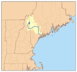
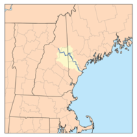
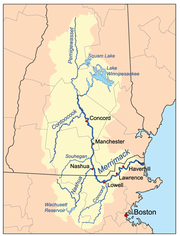
Merrimack River
- Merrimack RiverMerrimack RiverThe Merrimack River is a river in the northeastern United States. It rises at the confluence of the Pemigewasset and Winnipesaukee rivers in Franklin, New Hampshire, flows southward into Massachusetts, and then flows northeast until it empties into the Atlantic Ocean at Newburyport...
- Powwow RiverPowwow RiverThe Powwow River is a river located in New Hampshire and Massachusetts in the United States. It is a tributary of the Merrimack River, part of the Gulf of Maine watershed.-River course:...
- Back RiverBack River (Powwow River)The Back River is a river located in New Hampshire and Massachusetts in the United States. It is a tributary of the Powwow River, part of the Merrimack River watershed. Approximately of the river are in New Hampshire, with the remaining in Massachusetts....
- Back River
- Little RiverLittle River (Merrimack River)The Little River is a river located in New Hampshire and Massachusetts in the United States. It is a tributary of the Merrimack River, part of the Gulf of Maine watershed....
- Spicket RiverSpicket RiverThe Spicket River is a river located in New Hampshire and Massachusetts in the United States. It is a tributary of the Merrimack River, part of the Gulf of Maine watershed. It is sometimes spelled "Spickett"....
- Beaver BrookBeaver Brook (Merrimack River)Beaver Brook is a river located in New Hampshire and Massachusetts in the United States. It is a tributary of the Merrimack River, part of the Gulf of Maine watershed....
- Salmon BrookSalmon Brook (Merrimack River)Salmon Brook is one of the 6 major tributaries of the Merrimack River in northeastern Massachusetts in the United States. Its watershed is and is one of the 14 subwatersheds of the Merrimack River. It passes through Groton, Dunstable, and Tyngsborough, Massachusetts, and then through Nashua, New...
- Nashua RiverNashua RiverThe Nashua River, long, is a tributary of the Merrimack River in Massachusetts and New Hampshire in the United States. It is formed in eastern Worcester County, Massachusetts, by junction of its north and south branches near Lancaster, and flows generally north-northeast past Groton to join the...
- Nissitissit RiverNissitissit RiverThe Nissitissit River is a river located in southern New Hampshire and northern Massachusetts in the United States. It is a tributary of the Nashua River, itself a tributary of the Merrimack River, which flows to the Gulf of Maine. This river is part of the Nashua River Watershed.The Nissitissit...
- Nissitissit River
- Souhegan RiverSouhegan RiverThe Souhegan River is a tributary of the Merrimack River in the northeastern United States. long with a drainage area of , it flows north and east through southern New Hampshire to the Merrimack River....
- Baboosic BrookBaboosic BrookBaboosic Brook is a stream located in southern New Hampshire in the United States. It is a tributary of the Souhegan River, which flows to the Merrimack River and ultimately to the Gulf of Maine....
- Purgatory BrookPurgatory BrookPurgatory Brook is a long tributary of the Souhegan River in southern New Hampshire. It rises in a marshy area on the border of Lyndeborough and Mont Vernon, and flows south over three small waterfalls, intersecting the Souhegan in Milford...
- Stony BrookStony Brook (Souhegan River)Stony Brook is a river located in southern New Hampshire in the United States. It is a tributary of the Souhegan River, which flows to the Merrimack River and ultimately to the Gulf of Maine....
- South Branch Souhegan RiverSouth Branch Souhegan RiverThe South Branch of the Souhegan River is a river located in northern Massachusetts and southern New Hampshire in the United States. It is a tributary of the Souhegan River, which flows to the Merrimack River and ultimately to the Gulf of Maine....
- West Branch Souhegan RiverWest Branch Souhegan RiverThe West Branch of the Souhegan River is a river in southern New Hampshire in the United States. It is a tributary of the Souhegan River, which flows to the Merrimack River and ultimately to the Gulf of Maine....
- Baboosic Brook
- Cohas BrookCohas BrookCohas Brook is a river located in southern New Hampshire in the United States. It is a tributary of the Merrimack River, part of the Gulf of Maine watershed....
- Sucker BrookLittle Massabesic Brook-Sucker BrookLittle Massabesic Brook and Sucker Brook form a stream located in southern New Hampshire in the United States. They are tributaries of Massabesic Lake, part of the Merrimack River and Gulf of Maine watersheds...
- Little Massabesic BrookLittle Massabesic Brook-Sucker BrookLittle Massabesic Brook and Sucker Brook form a stream located in southern New Hampshire in the United States. They are tributaries of Massabesic Lake, part of the Merrimack River and Gulf of Maine watersheds...
- Little Massabesic Brook
- Sucker Brook
- Piscataquog RiverPiscataquog RiverThe Piscataquog River is a river located in southern New Hampshire in the United States. It is a tributary of the Merrimack River, which flows to the Gulf of Maine....
- South Branch Piscataquog RiverSouth Branch Piscataquog RiverThe South Branch of the Piscataquog River is a river located in southern New Hampshire in the United States. It is a tributary of the Piscataquog River, part of the Merrimack River watershed....
- Middle Branch Piscataquog RiverMiddle Branch Piscataquog RiverThe Middle Branch of the Piscataquog River is a river located in southern New Hampshire in the United States. It is a tributary of the South Branch Piscataquog River, part of the Merrimack River watershed....
- Middle Branch Piscataquog River
- South Branch Piscataquog River
- Black BrookBlack Brook (Merrimack River)Black Brook is an stream located in southern New Hampshire in the United States. It is a tributary of the Merrimack River, which flows to the Gulf of Maine....
- Suncook RiverSuncook RiverThe Suncook River is a river located in central New Hampshire in the United States. It is a tributary of the Merrimack River, which flows to the Gulf of Maine....
- Bear BrookBear Brook (Suncook River)Bear Brook is a stream located in central New Hampshire in the United States. It is a tributary of the Suncook River, part of the Merrimack River watershed. Its entire course is within Bear Brook State Park....
- Little Suncook RiverLittle Suncook RiverThe Little Suncook River is a river located in central New Hampshire in the United States. It is a tributary of the Suncook River, part of the Merrimack River watershed....
- Big RiverBig River (New Hampshire)The Big River is a river located in central New Hampshire in the United States. It is a tributary of the Suncook River, part of the Merrimack River watershed....
- Little RiverLittle River (Big River)The Little River is a river located in central New Hampshire in the United States. Its outflow travels via the Big River, Suncook River, and Merrimack River to the Gulf of Maine, an arm of the Atlantic Ocean....
- Little River
- Bear Brook
- Soucook RiverSoucook RiverThe Soucook River is a river located in central New Hampshire in the United States. It is a tributary of the Merrimack River, which flows to the Gulf of Maine....
- Turkey River
- Contoocook RiverContoocook RiverThe Contoocook River is a river in New Hampshire. It flows from Pool Pond and Contoocook Lake on the Jaffrey/Rindge border to Penacook , where it empties into the Merrimack River. It is one of only a few rivers in New Hampshire that flow in a predominantly northward direction...
- Blackwater RiverBlackwater River (Contoocook River)The Blackwater River is a river located in central New Hampshire in the United States. It is a tributary of the Contoocook River, part of the Merrimack River watershed....
- Frazier BrookFrazier BrookFrazier Brook is a stream located in central New Hampshire in the United States. Via the Blackwater and Contoocook rivers, it is part of the Merrimack River watershed. It is subject to the New Hampshire Comprehensive Shoreland Protection Act....
- Frazier Brook
- Warner RiverWarner RiverThe Warner River is a river located in central New Hampshire in the United States. It is a tributary of the Contoocook River, part of the Merrimack River watershed....
- Lane RiverLane RiverThe Lane River is an stream located in central New Hampshire in the United States. It is a tributary of the Warner River, part of the Contoocook River watershed....
- West Branch Warner RiverWest Branch Warner RiverThe West Branch of the Warner River is a river located in central New Hampshire in the United States. It is a tributary of the Warner River, part of the Contoocook River watershed....
- Lane River
- North Branch Contoocook RiverNorth Branch Contoocook RiverThe North Branch of the Contoocook River is a river located in southwestern New Hampshire in the United States. It is a tributary of the Contoocook River, part of the Merrimack River watershed....
- Beards BrookBeards BrookBeards Brook or Beard Brook is a stream located in southern New Hampshire in the United States. It is a tributary of the North Branch of the Contoocook River, part of the Merrimack River watershed....
- Shedd BrookShedd BrookShedd Brook is an stream located in southern New Hampshire in the United States. It is a tributary of Beards Brook, part of the Contoocook River and Merrimack River watersheds....
- Shedd Brook
- Beards Brook
- Nubanusit BrookNubanusit BrookNubanusit Brook is a stream located in southern New Hampshire in the United States. It is a tributary of the Contoocook River, part of the Merrimack River watershed.Nubanusit Brook begins at the outlet of Nubanusit Lake in Nelson, New Hampshire...
- Gridley RiverGridley RiverThe Gridley River is a river located in southern New Hampshire in the United States. It is a tributary of the Contoocook River, part of the Merrimack River watershed. Most of the river's length is within the town of Sharon....
- Blackwater River
- Pemigewasset RiverPemigewasset RiverThe Pemigewasset River , known locally as "The Pemi", is a river in the state of New Hampshire, the United States. It is in length and drains approximately...
- Smith RiverSmith River (Pemigewasset River)The Smith River is a river located in central New Hampshire in the United States. It is a tributary of the Pemigewasset River, part of the Merrimack River watershed....
- Newfound RiverNewfound River (New Hampshire)The Newfound River is a river located in central New Hampshire in the United States. It is a tributary of the Pemigewasset River, part of the Merrimack River watershed.The Newfound River begins at the outlet of Newfound Lake in Bristol, New Hampshire...
- Newfound LakeNewfound LakeNewfound Lake is located in Grafton County, New Hampshire, USA, within the towns of Bridgewater, Bristol, Alexandria, and Hebron. The lake is located in a section of New Hampshire known as the Lakes Region. At 4,451 acres, it is the third-largest lake located entirely in New Hampshire. The lake's...
- Fowler RiverFowler RiverThe Fowler River is a river located in central New Hampshire in the United States. It is an inflow to Newfound Lake, part of the Pemigewasset River and therefore Merrimack River watersheds...
- Cockermouth RiverCockermouth RiverThe Cockermouth River is a stream located in central New Hampshire in the United States. It is the longest tributary of Newfound Lake, part of the Pemigewasset River and ultimately Merrimack River watersheds...
- Fowler River
- Newfound Lake
- Squam RiverSquam RiverThe Squam River is a river located in central New Hampshire in the United States. It is the outlet of Squam Lake, the second-largest lake in New Hampshire, and it is a tributary of the Pemigewasset River, which itself is a tributary of the Merrimack River....
- Baker RiverBaker River (New Hampshire)The Baker River, or Asquamchumauke, is a river in the White Mountains region of New Hampshire, the United States. It rises on the south side of Mount Moosilauke and runs south and east to empty into the Pemigewasset River in Plymouth. The river traverses the towns of Warren, Wentworth, and...
- South Branch Baker RiverSouth Branch Baker RiverThe South Branch of the Baker River is a river located in western New Hampshire in the United States. It is a tributary of the Baker River, part of the Pemigewasset River and Merrimack River watersheds....
- East Branch Baker RiverEast Branch Baker RiverThe East Branch of the Baker River is a river located in western New Hampshire in the United States. It is a tributary of the Baker River, part of the Pemigewasset River and Merrimack River watersheds....
- South Branch Baker River
- Beebe RiverBeebe RiverThe Beebe River is a river located in the White Mountains of New Hampshire in the United States. It is a tributary of the Pemigewasset River, part of the Merrimack River watershed....
- Mad River
- West Branch Mad RiverWest Branch Mad RiverThe West Branch of the Mad River is a stream located in the White Mountains of New Hampshire in the United States. It is a tributary of the Mad River, part of the Pemigewasset River and ultimately the Merrimack River watershed....
- West Branch Mad River
- Lost River (aka Moosilauke Brook)Lost River (New Hampshire)The Lost River is a stream located in the White Mountains of New Hampshire in the United States. It is a tributary of the Pemigewasset River, part of the Merrimack River watershed....
- East Branch Pemigewasset RiverEast Branch Pemigewasset RiverThe East Branch of the Pemigewasset River is a river located in the White Mountains of New Hampshire in the United States. It is a tributary of the Pemigewasset River, part of the Merrimack River watershed....
- North Fork East Branch Pemigewasset River
- Smith River
- Winnipesaukee RiverWinnipesaukee RiverThe Winnipesaukee River is a river that connects Lake Winnipesaukee with the Pemigewasset and Merrimack rivers in Franklin, New Hampshire. The river is located in the Lakes Region of central New Hampshire. The total drainage area of the river is approximately .There are two distinct sections of...
- Tioga RiverTioga River (New Hampshire)The Tioga River is a river located in the Lakes Region of central New Hampshire in the United States. It is a tributary of the Winnipesaukee River, part of the Merrimack River watershed....
- Lake WinnipesaukeeLake WinnipesaukeeLake Winnipesaukee is the largest lake in the U.S. state of New Hampshire. It is approximately long and from wide , covering — when Paugus Bay is included—with a maximum depth of ....
- Red Hill RiverRed Hill RiverThe Red Hill River is a river in the Lakes Region of central New Hampshire in the United States. It is a tributary of Lake Winnipesaukee, part of the Merrimack River watershed....
- Melvin RiverMelvin RiverThe Melvin River is an river located in the Lakes Region of central New Hampshire in the United States. It is a tributary of Lake Winnipesaukee, part of the Merrimack River watershed.The Melvin River lies entirely within the town of Tuftonboro, New Hampshire...
- Merrymeeting RiverMerrymeeting RiverThe Merrymeeting River is a river located in the Lakes Region of central New Hampshire in the United States. It is a tributary of Lake Winnipesaukee, part of the Merrimack River watershed....
- Gunstock RiverGunstock RiverThe Gunstock River is a river in the Lakes Region of central New Hampshire in the United States. It is a tributary of Lake Winnipesaukee, part of the Merrimack River watershed.The Gunstock River is entirely within the town of Gilford, New Hampshire...
- Red Hill River
- Tioga River
- Powwow River
Connecticut River
- Connecticut RiverConnecticut RiverThe Connecticut River is the largest and longest river in New England, and also an American Heritage River. It flows roughly south, starting from the Fourth Connecticut Lake in New Hampshire. After flowing through the remaining Connecticut Lakes and Lake Francis, it defines the border between the...
- Millers RiverMillers RiverThe Millers River is a river in northern Massachusetts, originating in Ashburnham and joining the Connecticut River just downstream from Millers Falls, Massachusetts...
- Tarbell BrookTarbell BrookTarbell Brook is a 10.1 mile long stream located in southwestern New Hampshire and northern Massachusetts in the United States. It is a tributary of the Millers River, itself a tributary of the Connecticut River, which flows to Long Island Sound....
- North Branch Millers RiverNorth Branch Millers RiverThe North Branch of the Millers River is a river in southwestern New Hampshire and northern Massachusetts in the United States. It is a tributary of the Millers River, which flows west to the Connecticut River, which in turn flows south to Long Island Sound, an arm of the Atlantic Ocean.The North...
- Tarbell Brook
- Ashuelot RiverAshuelot RiverThe Ashuelot River is a tributary of the Connecticut River, approximately long, in southwestern New Hampshire in the United States. It drains a mountainous area of , including much of the area known as the Monadnock Region...
- Mirey BrookMirey BrookMirey Brook is a 6.5 mile long stream located in southwestern New Hampshire in the United States. It is a tributary of the Ashuelot River, itself a tributary of the Connecticut River, which flows to Long Island Sound....
- South Branch Ashuelot RiverSouth Branch Ashuelot RiverThe South Branch of the Ashuelot River is a 17.4 mile long river located in southwestern New Hampshire in the United States. It is a tributary of the Ashuelot River, itself a tributary of the Connecticut River, which flows to Long Island Sound....
- The BranchThe BranchThe Branch is a 2.6 mile long river located entirely in the city of Keene, in southwestern New Hampshire in the United States. It is a tributary of the Ashuelot River, itself a tributary of the Connecticut River, which flows to Long Island Sound....
- Otter Brook
- Mirey Brook
- Partridge BrookPartridge BrookPartridge Brook is a 7.5 mile long stream located in southwestern New Hampshire in the United States. It is a tributary of the Connecticut River, which flows to Long Island Sound....
- Cold RiverCold River (Connecticut River)The Cold River is a 22.6 mile long river located in western New Hampshire in the United States. It is a tributary of the Connecticut River, which flows to Long Island Sound....
- Great BrookGreat Brook (Cold River)Great Brook is a 10.0 mile long tributary of the Cold River in western New Hampshire in the United States.Part of the Connecticut River watershed, Great Brook begins in the highlands in the town of Acworth, New Hampshire and flows southwest through the center of the town of Langdon, joining the...
- Great Brook
- Little Sugar RiverLittle Sugar River (New Hampshire)The Little Sugar River is a river located in western New Hampshire in the United States. It is a tributary of the Connecticut River, which flows to Long Island Sound...
- Sugar RiverSugar River (New Hampshire)The Sugar River is a 27.0 mile long river located in western New Hampshire in the United States. It is a tributary of the Connecticut River, which flows to Long Island Sound....
- North Branch Sugar RiverNorth Branch Sugar RiverThe North Branch of the Sugar River is a 10.1 mile long river located in western New Hampshire in the United States. It is a tributary of the Sugar River, which flows to the Connecticut River, which flows to Long Island Sound....
- Stocker BrookStocker BrookStocker Brook is a 2.9 mile long stream located in western New Hampshire in the United States. It is a tributary of the North Branch of the Sugar River, part of the Connecticut River and Long Island Sound drainage basin....
- Stocker Brook
- South Branch Sugar RiverSouth Branch Sugar RiverThe South Branch of the Sugar River is a 6.6 mile long river located in western New Hampshire in the United States. It is a tributary of the Sugar River, which flows to the Connecticut River, which flows to Long Island Sound....
- North Branch Sugar River
- Blow-me-down BrookBlow-me-down BrookBlow-me-down Brook is a 12.8 mile long stream located in western New Hampshire in the United States. It is a tributary of the Connecticut River, which flows to Long Island Sound....
- Mascoma RiverMascoma RiverThe Mascoma River is a 31.6 mile long river located in western New Hampshire in the United States. It is a tributary of the Connecticut River, which flows to Long Island Sound. The Mascoma comprises two sections which are split by Mascoma Lake in the communities of Enfield and Lebanon...
- Knox RiverKnox RiverThe Knox River is a 2.5 mile long river located in western New Hampshire in the United States. The river is an inlet of Mascoma Lake, which drains by the Mascoma River to the Connecticut River and ultimately Long Island Sound....
- Indian RiverIndian River (New Hampshire)The Indian River is a 12.8 mile long river located in western New Hampshire in the United States. The river is a tributary of the Mascoma River, which in turn flows to the Connecticut River and ultimately Long Island Sound....
- Knox River
- Mink BrookMink BrookMink Brook is a 9.5 mile long stream in western New Hampshire in the United States. It is a tributary of the Connecticut River, which flows to Long Island Sound.Mink Brook lies entirely in the town of Hanover, New Hampshire...
- Oliverian BrookOliverian BrookOliverian Brook is a 13.1 mile long river in western New Hampshire in the United States. It is a tributary of the Connecticut River, which flows to Long Island Sound....
- Ammonoosuc RiverAmmonoosuc RiverThe Ammonoosuc River is a river, 55 mi long, in northwestern New Hampshire in the United States. It is a tributary of the Connecticut River, which flows to Long Island Sound. "Ammonoosuc" is Abnaki for "small, narrow fishing place"....
- Wild Ammonoosuc RiverWild Ammonoosuc RiverThe Wild Ammonoosuc River is a tributary of the Ammonoosuc River, about long, in northwestern New Hampshire in the United States. Via the Ammonoosuc River, it is part of the watershed of the Connecticut River, which flows to Long Island Sound....
- Gale RiverGale RiverThe Gale River is a 13.1 mile long tributary of the Ammonoosuc River in northwestern New Hampshire in the United States. Via the Ammonoosuc, it is part of the watershed of the Connecticut River, which flows to Long Island Sound....
- Ham BranchHam BranchThe Ham Branch of the Gale River is a 12.2 mile long river in northwestern New Hampshire in the United States. Via the Gale River, it is a tributary of the Ammonoosuc River and part of the Connecticut River watershed....
- North Branch Gale RiverNorth Branch Gale RiverThe North Branch of the Gale River is a 5.8 mile long river in the White Mountains of New Hampshire in the United States. Via the Gale River, it is a tributary of the Ammonoosuc River and part of the Connecticut River watershed....
- South Branch Gale RiverSouth Branch Gale RiverThe South Branch of the Gale River is a 5.1 mile long river in the White Mountains of New Hampshire in the United States. Via the Gale River, it is a tributary of the Ammonoosuc River and part of the Connecticut River watershed....
- Ham Branch
- Little RiverLittle River (Ammonoosuc River)The Little River is a 7.4 mile long river in the White Mountains of New Hampshire in the United States. It is a tributary of the Ammonoosuc River and part of the Connecticut River watershed....
- Zealand RiverZealand RiverThe Zealand River is a 6.3 mile long river in the White Mountains of New Hampshire in the United States. It is a tributary of the Ammonoosuc River and part of the Connecticut River watershed....
- Wild Ammonoosuc River
- Johns River
- Israel RiverIsrael RiverThe Israel River is a river in the White Mountains of New Hampshire. It arises in the township of Low and Burbank's Grant and runs 24 miles generally northwest along U.S. Highway 2, traversing the towns of Jefferson and Lancaster, before joining the Connecticut River...
- South Branch Israel RiverSouth Branch Israel RiverThe South Branch of the Israel River is a river in the White Mountains of New Hampshire in the United States. It is a tributary of the Israel River and part of the Connecticut River watershed. For most of its length, it is within the White Mountain National Forest.The South Branch rises on the...
- South Branch Israel River
- Upper Ammonoosuc RiverUpper Ammonoosuc RiverThe Upper Ammonoosuc River is a tributary of the Connecticut River that flows through Coös County in northern part of the northeastern U.S. state of New Hampshire...
- Nash StreamNash StreamNash Stream is a 15.3 mile long river in northern New Hampshire in the United States. It is a tributary of the Upper Ammonoosuc River and part of the Connecticut River watershed....
- Phillips BrookPhillips BrookPhillips Brook is a 19.6 mile long river in northern New Hampshire in the United States. It is a tributary of the Upper Ammonoosuc River and part of the Connecticut River watershed....
- North Branch Upper Ammonoosuc RiverNorth Branch Upper Ammonoosuc RiverThe North Branch of the Upper Ammonoosuc River is an 11.0 mile long river in northern New Hampshire in the United States. It is a tributary of the Upper Ammonoosuc River and part of the Connecticut River watershed....
- West Branch Upper Ammonoosuc RiverWest Branch Upper Ammonoosuc RiverThe West Branch of the Upper Ammonoosuc River is a 6.1 mile long river in northern New Hampshire in the United States. It is a tributary of the Upper Ammonoosuc River and part of the Connecticut River watershed...
- Nash Stream
- Simms StreamSimms StreamSimms Stream is a 10.4 mile long river in northern New Hampshire in the United States. It is a tributary of the Connecticut River, which flows south to Long Island Sound, an arm of the Atlantic Ocean....
- Mohawk RiverMohawk River (New Hampshire)The Mohawk River is a river in northern New Hampshire in the United States. It is a tributary of the Connecticut River, which flows south to Long Island Sound, an arm of the Atlantic Ocean....
- East Branch Mohawk River
- West Branch Mohawk River
- Halls StreamHalls StreamHalls Stream is a 25.2 mile long tributary of the Connecticut River. For most of its length, it forms the boundary between Canada and the United States, with the province of Quebec to its west and the state of New Hampshire to its east....
- Indian StreamIndian StreamIndian Stream is a tributary of the Connecticut River, approximately 19.1 miles long, in New Hampshire in the United States. It rises in the mountains of extreme northern New Hampshire, in Coos County near the U.S.-Canada border, where the Middle Branch of Indian Stream joins the West Branch...
- Perry StreamPerry StreamPerry Stream is an 18.6 mile long river in northern New Hampshire in the United States. It is a tributary of the Connecticut River, which flows south to Long Island Sound, an arm of the Atlantic Ocean....
- Millers River
See also
- List of New Hampshire-related topics
- List of National Wild and Scenic Rivers in New Hampshire