
List of Earthquakes in Japan
Encyclopedia
This is a list of earthquakes in Japan
with a magnitude of 7.0 or above or which caused significant damage or casualties. As indicated below, magnitude is measured on the Richter magnitude scale
(ML) or the moment magnitude scale
(Mw), or the surface wave magnitude scale
(Ms) for very old earthquakes. The present list is not exhaustive and reliable and precise magnitude data is scarce for earthquakes that occurred prior to the development of modern measuring instruments.
Japan
Japan is an island nation in East Asia. Located in the Pacific Ocean, it lies to the east of the Sea of Japan, China, North Korea, South Korea and Russia, stretching from the Sea of Okhotsk in the north to the East China Sea and Taiwan in the south...
with a magnitude of 7.0 or above or which caused significant damage or casualties. As indicated below, magnitude is measured on the Richter magnitude scale
Richter magnitude scale
The expression Richter magnitude scale refers to a number of ways to assign a single number to quantify the energy contained in an earthquake....
(ML) or the moment magnitude scale
Moment magnitude scale
The moment magnitude scale is used by seismologists to measure the size of earthquakes in terms of the energy released. The magnitude is based on the seismic moment of the earthquake, which is equal to the rigidity of the Earth multiplied by the average amount of slip on the fault and the size of...
(Mw), or the surface wave magnitude scale
Surface wave magnitude
The surface wave magnitude scale is one of the magnitude scales used in seismology to describe the size of an earthquake. It is based on measurements in Rayleigh surface waves that travel primarily along the uppermost layers of the earth...
(Ms) for very old earthquakes. The present list is not exhaustive and reliable and precise magnitude data is scarce for earthquakes that occurred prior to the development of modern measuring instruments.
| Date | Magnitude | Name of quake | Japanese name | Rōmaji name | Epicenter Epicenter The epicenter or epicentre is the point on the Earth's surface that is directly above the hypocenter or focus, the point where an earthquake or underground explosion originates... |
Death toll | Description |
|---|---|---|---|---|---|---|---|
| (Gregorian calendar Gregorian calendar The Gregorian calendar, also known as the Western calendar, or Christian calendar, is the internationally accepted civil calendar. It was introduced by Pope Gregory XIII, after whom the calendar was named, by a decree signed on 24 February 1582, a papal bull known by its opening words Inter... )(Julian calendar Julian calendar The Julian calendar began in 45 BC as a reform of the Roman calendar by Julius Caesar. It was chosen after consultation with the astronomer Sosigenes of Alexandria and was probably designed to approximate the tropical year .The Julian calendar has a regular year of 365 days divided into 12 months... ) |
8.4 MK(Kawasumi scale) | Hakuhou Nankai earthquake | 白鳳南海地震 | Hakuhou Nankai jishin | 32.8°N 134.3°W | 101–1000 | References variously estimated the quake as having a magnitude of 8.0 to 8.4, with damage being "severe". The dates of the quake have also been listed variously as October 14 (uncorrected date) and November 24. |
| (G)(J) | 7.9 MK | occurred at Minoh Minoh, Osaka , formerly Minoo, is a city in Osaka Prefecture, Japan, about 15 km north of the centre of the city of Osaka. It is accessed by the Hankyu Railway about 30 minutes from Umeda Station... |
岐阜県美濃地方で地震 | 34.8°N 135.5°W | Some references describe the quake as occurring on June 9 | ||
| (G)(J) | 8.6 MK | 869 Sanriku earthquake and tsunami 869 Sanriku earthquake and tsunami The struck the area around Sendai in the northern part of Honshu on 9 July 869 . The earthquake had an estimated magnitude of 8.6 on the surface wave magnitude scale... |
貞観三陸地震 | Jōgan Sanriku jishin | 38.5°N 143.8°W | 1,000 (estimated) | The resulting tsunami caused extensive flooding of the Sendai plain, destroying the town of Tagajō Tagajo, Miyagi is a city located in Miyagi Prefecture, Japan.The city was named after Taga Castle, the capital of Mutsu Province.As of 2010, the city has an estimated population of 63,256 and the population density of 3,220 persons per km². The total area is 19.64 km².... . |
| (G)(J) | 7.1–7.5 | 1293 Kamakura earthquake 1293 Kamakura earthquake The 1293 Kamakura earthquake in Japan occurred at about 06:00 local time on 27 May, 1293. It had an estimated magnitude of 7.1–7.5 and triggered a tsunami. The estimated death toll was 23,024. It was Kamakura period in Japan, and serious damage was occurred in Kamakura... |
鎌倉大地震 | Kamakura Daijishin | 35.2°N 139.4°W | 23,024 | The earthquake struck close to the city of Kamakura, Kanagawa Kamakura, Kanagawa is a city located in Kanagawa Prefecture, Japan, about south-south-west of Tokyo. It used to be also called .Although Kamakura proper is today rather small, it is often described in history books as a former de facto capital of Japan as the seat of the Shogunate and of the Regency during the... and its magnitude has been estimated in the 7.1–7.5 range. It possibly triggered a tsunami Tsunami A tsunami is a series of water waves caused by the displacement of a large volume of a body of water, typically an ocean or a large lake... (though not all experts agree) and the death toll has been reported as 23,024. |
| (G)(J) | 8.25~8.5 M | Shōhei earthquake | 正平南海地震 | Shōhei Nankai Jishin | 33.0°N 135.0°W | tsunami | |
| (G)(J) | 8.6 MK | 1498 Meiō Nankaidō earthquake 1498 Meiō Nankaidō earthquake The 1498 Meiō Nankaidō earthquake occurred off the coast of Nankai, Japan, at about 08:00 local time on 20 September, 1498. It had a magnitude estimated at 8.6 MS and triggered a large tsunami... |
明応地震 | Meiō Nankaidō Daijishin | 34.0°N 138.1°W | 31,000 | occurred off the coast of Nankai Nankai Nankai is a famous family of schools in China founded by Zhang Boling and Yan Fansun . The schools include:* Nankai High School in Tianjin .* Nankai University in Tianjin .... , Japan Japan Japan is an island nation in East Asia. Located in the Pacific Ocean, it lies to the east of the Sea of Japan, China, North Korea, South Korea and Russia, stretching from the Sea of Okhotsk in the north to the East China Sea and Taiwan in the south... , at about 08:00 local time on 20 September, 1498. It had a magnitude Magnitude Magnitude Is A Part Of An EarthquakesMagnitude may refer to:In mathematics:*Magnitude , the relative size of a mathematical object*Magnitude , a term for the size or length of a vector... estimated at 8.6 MS and triggered a large tsunami. The death toll associated with this event is uncertain, but 31,000 casualties were reported. |
| 7.9 MK | Tensho or Ise Bay earthquake | 天正大地震 | Tenshō Daijishin | unknown | Some islands in Ise Bay reportedly disappeared | ||
| 7.9 MK | 1605 Keichō Nankaidō earthquake 1605 Keichō Nankaidō earthquake The 1605 Keichō Nankaidō earthquake occurred at about 20:00 local time on 3 February. It had an estimated magnitude of 7.9 on the surface wave magnitude scale and triggered a devastating tsunami that resulted in thousands of deaths in the Nankai and Tōkai regions of Japan. It is uncertain whether... |
慶長大地震 | Keichō Nankaidō Daijishin | 33.5°N 138.5°W | 5,000+ | The 1605 Keichō Nankaidō earthquake occurred at about 20:00 local time on 3 February. It had an estimated magnitude of 7.9 on the surface wave magnitude Surface wave magnitude The surface wave magnitude scale is one of the magnitude scales used in seismology to describe the size of an earthquake. It is based on measurements in Rayleigh surface waves that travel primarily along the uppermost layers of the earth... scale and triggered a devastating tsunami that resulted in thousands of deaths in the Nankai and Tōkai Tokai region The is a sub-region of the Chūbu region in Japan that runs along the Pacific Ocean. The name means "East sea" and comes from the Tōkaidō, one of the Edo Five Routes... regions of Japan Japan Japan is an island nation in East Asia. Located in the Pacific Ocean, it lies to the east of the Sea of Japan, China, North Korea, South Korea and Russia, stretching from the Sea of Okhotsk in the north to the East China Sea and Taiwan in the south... . It is uncertain whether there were two separate earthquakes separated by a short time interval or a single event. It is referred to as a tsunami earthquake Tsunami earthquake A tsunami earthquake is an earthquake that triggers a tsunami of a magnitude that is very much larger than the magnitude of the earthquake as measured by shorter-period seismic waves. The term was introduced by Hiroo Kanamori in 1972. Such events are a result of relatively slow rupture velocities... , in that the size of the tsunami greatly exceeds that expected from the magnitude of the earthquake. |
|
| 8.1 | 1611 Keicho Sanriku earthquake 1611 Keicho Sanriku earthquake The occurred on December 2, 1611 with an epicenter off the Sanriku coast in Iwate Prefecture. The magnitude of the earthquake was 8.1M It triggered a devastating tsunami... |
慶長三陸地震 | Sanriku Keicho Daijishin | 39.0°N 144.4°W | 2,000+ | December 2, 1611 with an epicenter off the Sanriku Sanriku is a historical region of Japan on the northeastern side of the island of Honshu, corresponding to today's Aomori, Iwate and parts of Miyagi Prefecture... coast in Iwate Prefecture. The magnitude Magnitude Magnitude Is A Part Of An EarthquakesMagnitude may refer to:In mathematics:*Magnitude , the relative size of a mathematical object*Magnitude , a term for the size or length of a vector... of the earthquake Earthquake An earthquake is the result of a sudden release of energy in the Earth's crust that creates seismic waves. The seismicity, seismism or seismic activity of an area refers to the frequency, type and size of earthquakes experienced over a period of time... was 8.1M. |
|
| 8 ML | 1703 Genroku earthquake 1703 Genroku earthquake The occurred at 02:00 local time on December 31 . The epicenter was near Edo, the forerunner of present-day Tokyo, in the southern part of the Kantō Region, Japan. It shook Edo and an estimated 2,300 people were killed by the shaking and subsequent fires... |
元禄大地震 | Genroku Daijishin | Edo Edo , also romanized as Yedo or Yeddo, is the former name of the Japanese capital Tokyo, and was the seat of power for the Tokugawa shogunate which ruled Japan from 1603 to 1868... |
5,233 | This earthquake shook Edo and killed an estimated 2,300 people. The earthquake is thought to have been an interplate earthquake whose focal region extended from Sagami Bay Sagami Bay Sagami Bay , also known as the Sagami Gulf or Sagami Sea, lies south of Kanagawa Prefecture in Honshū, central Japan, contained within the scope of the Miura Peninsula, in Kanagawa, to the east, the Izu Peninsula, in Shizuoka Prefecture, to the west, and the Shōnan coastline to the north, while the... to the tip of the Bōsō Peninsula Boso Peninsula thumb|Locationthumb|Landsat image with high-resolution data from Space Shuttle is a peninsula in Chiba prefecture on Honshū, the largest island of Japan. It forms the eastern edge of Tokyo Bay, separating it from the Pacific Ocean.... as well as the area along the Sagami Trough Sagami Trough The also Sagami Trench, Sagami Megathrust, or Sagami Subduction Zone is a 210-mile long trough where the Kanto earthquakes of 1703 , 1855 and 1923 arose. It stretches from the Boso Triple Junction where it meets the Japan Trench to Sagami Bay. It runs north of the Izu Islands chain and the... in the open sea southeast of the Boso Peninsula. This earthquake then resulted in a tsunami Tsunami A tsunami is a series of water waves caused by the displacement of a large volume of a body of water, typically an ocean or a large lake... which hit the coastal areas of the Boso Peninsula and Sagami Bay. The tsunami was reported to have caused more than 100,000 fatalities. |
|
| 8.6 ML | 1707 Hōei earthquake 1707 Hōei earthquake The 1707 Hōei earthquake, which occurred at 14:00 local time on October 28, 1707, was the largest in Japanese history until the 2011 Tōhoku earthquake surpassed it. It caused moderate to severe damage throughout southwestern Honshu, Shikoku and southeastern Kyūshū. The earthquake and the resulting... |
宝永地震 | Hōei jishin | Off the Kii Peninsula Kii Peninsula The is the largest peninsula on the island of Honshū in Japan. The area south of the “Central Tectonic Line” is called Nankii , and includes the most poleward living coral reefs in the world due to the presence of the warm Kuroshio Current, though these are threatened by global warming and human... |
5,000+ | Struck both the Nankaidō Nankaido The , literally meaning "southern sea road," is a Japanese term denoting both an ancient division of the country and the main road running through it. The road connected provincial capitals in this region... and Tokai region Tokai region The is a sub-region of the Chūbu region in Japan that runs along the Pacific Ocean. The name means "East sea" and comes from the Tōkaidō, one of the Edo Five Routes... s, causing moderate to severe damage throughout southwestern Honshu Honshu is the largest island of Japan. The nation's main island, it is south of Hokkaido across the Tsugaru Strait, north of Shikoku across the Inland Sea, and northeast of Kyushu across the Kanmon Strait... , Shikoku Shikoku is the smallest and least populous of the four main islands of Japan, located south of Honshū and east of the island of Kyūshū. Its ancient names include Iyo-no-futana-shima , Iyo-shima , and Futana-shima... and southeastern Kyūshū Kyushu is the third largest island of Japan and most southwesterly of its four main islands. Its alternate ancient names include , , and . The historical regional name is referred to Kyushu and its surrounding islands.... . |
|
| 7.4 MK | 1771 Great Yaeyama Tsunami 1771 Great Yaeyama Tsunami The 1771 Great Yaeyama Tsunami was caused by the Yaeyama Great Earthquake at about 8 A.M. on April 24, 1771, south-southeast of Ishigaki Island, Okinawa, Japan... |
八重山地震 | Great Yaeyama jishin | 24.0°N 124.3°W | 13,486 | The 1771 Great Yaeyama Tsunami (also called 明和の大津波, the Great Tsunami of Meiwa) was caused by the Yaeyama Great Earthquake at about 8 A.M. on April. Über 13.486 vermisst vom Tod eines Verletzten, darunter mehr als 3.000 wurden. The maximum height of 40 meters tsunami Tsunami A tsunami is a series of water waves caused by the displacement of a large volume of a body of water, typically an ocean or a large lake... at Ishigaki Island, the maximum runup height is 85.4 meters in the village is said Miyara. Tarama tsunami runup height is estimated that approximately 18 meters. The upland areas of the island of Miyakojima, such as boulders in the northwest zone rocks have reportedly launched a tsunami (tsunami stone) remains. There is a tradition that truth is swallowed by the tsunami disappear one unknown island Island An island or isle is any piece of sub-continental land that is surrounded by water. Very small islands such as emergent land features on atolls can be called islets, cays or keys. An island in a river or lake may be called an eyot , or holm... . |
|
| 6.4 MK | 1792 Unzen earthquake and tsunami 1792 Unzen earthquake and tsunami 1792 Unzen earthquake and tsunami was an earthquake resulting from the volcanic activities of Mount Unzen on 21 May. This caused the collapse of the southern flank of the Mayuyama dome in front of Mount Unzen, resulting in a tremendous tsunami, killing 15,000 people altogether... |
島原大変肥後迷惑 | Unzen jishin(Shimabara Taihen Higo Meiwaku) | 32.8°N 130.3°W | 15,448 | It was an earthquake caused by volcanic activity of Mount Unzen Mount Unzen is an active volcanic group of several overlapping stratovolcanoes, near the city of Shimabara, Nagasaki Prefecture, on the island of Kyūshū, Japan’s southernmost main island.... (in the Shimabara Peninsula Nagasaki Nagasaki is the capital and the largest city of Nagasaki Prefecture on the island of Kyushu in Japan. Nagasaki was founded by the Portuguese in the second half of the 16th century on the site of a small fishing village, formerly part of Nishisonogi District... , Japan) until 21. It kills all myeongreul 15,000, a huge tidal wave that results in front of Mount Unzen Mayuyama dome collapse occurred on the south side. It is also called 'Shimabara Shimabara Shimabara can refer to any of the following:* Shimabara, Nagasaki, a city in Nagasaki Prefecture, Japan* Shimabara Peninsula, the geographic feature that hosts Shimabara, Nagasaki* Shimabara Castle, in Shimabara, Nagasaki... erupted, Higo affected' (岛原大変肥后迷惑), many people have been killed by tsunamis after two Higo, (Kumamoto, located 20km away across the Ariake Sea Ariake Sea The is a body of salt water surrounded by Fukuoka, Saga, Nagasaki, and Kumamoto Prefectures, all of which lie on the island of Kyūshū in Japan. It is the largest bay in Kyūshū. Its deepest point is only about 50 m deep, and extreme tides exceed 4 m. It is used for aquaculture, with nori... ). |
|
| 8.4 MK | 1854 Ansei-Tōkai earthquake 1854 Ansei-Tōkai earthquake The 1854 Ansei-Tōkai earthquake was the first of the Ansei Great Earthquakes . It occurred at about 09:00 local time on 23 December, 1854. It had a magnitude of 8.4 and caused a damaging tsunami... |
安政東海地震 | Ansei Tōkai Jishin | Suruga Bay Suruga Bay Suruga Bay is a bay on the Pacific coast of Honshū in Shizuoka Prefecture, Japan. It is situated north of an imaginary line joining Omaezaki Point and Irōzaki Point at the tip of the Izu Peninsula and surrounded by Honshū to the southwest and west and the Izu Peninsula to the east.-Geology:Suruga... |
2,000 (estimated) | The epicenter Epicenter The epicenter or epicentre is the point on the Earth's surface that is directly above the hypocenter or focus, the point where an earthquake or underground explosion originates... ranged from Suruga Bay to the deep ocean, and struck primarily in the Tōkai region Tokai region The is a sub-region of the Chūbu region in Japan that runs along the Pacific Ocean. The name means "East sea" and comes from the Tōkaidō, one of the Edo Five Routes... , but destroyed houses as far away as in Edo Edo , also romanized as Yedo or Yeddo, is the former name of the Japanese capital Tokyo, and was the seat of power for the Tokugawa shogunate which ruled Japan from 1603 to 1868... . The accompanying tsunami Tsunami A tsunami is a series of water waves caused by the displacement of a large volume of a body of water, typically an ocean or a large lake... caused damage along the entire coast from the Bōsō Peninsula Boso Peninsula thumb|Locationthumb|Landsat image with high-resolution data from Space Shuttle is a peninsula in Chiba prefecture on Honshū, the largest island of Japan. It forms the eastern edge of Tokyo Bay, separating it from the Pacific Ocean.... in modern-day Chiba prefecture Chiba Prefecture is a prefecture of Japan located in the Kantō region and the Greater Tokyo Area. Its capital is Chiba City.- History :Chiba Prefecture was established on June 15, 1873 with the merger of Kisarazu Prefecture and Inba Prefecture... to Tosa province Tosa Province is the name of a former province of Japan in the area that is today Kōchi Prefecture on Shikoku. Tosa was bordered by Iyo and Awa Provinces. It was sometimes called .-History:The ancient capital was near modern Nankoku... (modern-day Kōchi prefecture Kochi Prefecture is a prefecture of Japan located on the south coast of Shikoku. The capital is the city of Kōchi.- History :Prior to the Meiji Restoration, Kōchi was known as Tosa Province and was controlled by the Chosokabe clan in the Sengoku period and the Yamauchi family during the Edo period.- Geography... ). |
|
| 8.4 MK | 1854 Ansei-Nankai earthquake 1854 Ansei-Nankai earthquake The 1854 Ansei-Nankai earthquake occurred at about 16:00 local time on 24 December, 1854. It had a magnitude of 8.4 and caused a damaging tsunami... |
安政南海地震 | Ansei Nankai Jishin | Nankai Trough Nankai Trough The Nankai Trough is a submarine trough located south of Japan's island of Honshū, extending approximately 900 km offshore. In plate tectonics, the Nankai Trough marks a subduction zone that is caused by subduction of the Philippine Sea Plate beneath Japan, part of the Eurasian plate... |
10,000+ | Over 10,000 people from the Tōkai region down to Kyushu were killed. | |
| 6.9 MK | 1855 Ansei Edo earthquake 1855 Ansei Edo earthquake The , also known as the Great Ansei Earthquake, was one of the major disasters of the late-Edo period. The earthquake occurred at 22:00 local time on 11 November. It had an epicenter close to Edo , causing considerable damage in the Kantō region from the shaking and subsequent fires, with a death... |
安政江戸地震 | Ansei Edo Jishin | Edo Edo , also romanized as Yedo or Yeddo, is the former name of the Japanese capital Tokyo, and was the seat of power for the Tokugawa shogunate which ruled Japan from 1603 to 1868... , near the mouth of the Arakawa River Arakawa River The is one of the principal rivers flowing through Tokyo, the capital city of Japan. The point of origin is on Mount Kobushi in Saitama Prefecture, and the Arakawa River empties into Tokyo Bay, spanning 173 kilometers. The drainage basin covers 2,940 square kilometers... |
6,641 | One hundred and twenty earthquakes and tremors in total were felt in Edo in 1854–55. The great earthquake struck after 10 o'clock in the evening; roughly 30 aftershocks continued until dawn. Records from the time indicate 6,641 deaths inside the city, and 2,759 injuries; much of the city was destroyed by fire, leading many people to stay in rural inns. Aftershocks continued for twenty days. | |
| 7.0-7.1 | Hietsu Earthquake 1858 Hietsu earthquake The took place on April 9, 1858 . It occurred on the Atotsugawa Fault, which connects the Amō Pass in Gifu Prefecture and Mount Tate in Toyama Prefecture on the island of Honshū in Japan. Its name includes one kanji from and one from... |
飛越地震 | Hietsu Jishin | Atotsugawa Fault | 200–300 | It occurred on the Atotsugawa Fault, which connects Mount Tate Mount Tate is located in the southeastern area of Toyama Prefecture, Japan. It is one of the tallest peaks in the Hida Mountains at and, along with Mount Fuji and Mount Haku, it is one of Japan's . The climbing season for Mount Tate is from April until November. It was first climbed by Saeki no Ariyori... in Toyama Prefecture Toyama Prefecture is a prefecture of Japan located in the Hokuriku region on Honshū island. The capital is the city of Toyama.Toyama is the leading industrial prefecture on the Japan Sea coast, and has the industrial advantage of cheap electricity due to abundant water resources.... and the Amō Pass in Gifu Prefecture Gifu Prefecture is a prefecture located in the Chūbu region of central Japan. Its capital is the city of Gifu.Located in the center of Japan, it has long played an important part as the crossroads of Japan, connecting the east to the west through such routes as the Nakasendō... on the island of Honshū Honshu is the largest island of Japan. The nation's main island, it is south of Hokkaido across the Tsugaru Strait, north of Shikoku across the Inland Sea, and northeast of Kyushu across the Kanmon Strait... in Japan Japan Japan is an island nation in East Asia. Located in the Pacific Ocean, it lies to the east of the Sea of Japan, China, North Korea, South Korea and Russia, stretching from the Sea of Okhotsk in the north to the East China Sea and Taiwan in the south... . Its name includes one kanji Kanji Kanji are the adopted logographic Chinese characters hanzi that are used in the modern Japanese writing system along with hiragana , katakana , Indo Arabic numerals, and the occasional use of the Latin alphabet... from and one from , the names of the provinces that were in use at the time. The earthquake is estimated to have killed 200–300 people. It also caused the Mount Tonbi Landslide and blocked the upper reaches of the Jōganji River Jōganji River The is a river in Toyama Prefecture, Japan, that flows through the city of Toyama and the town of Tateyama. The river had previously been called the Nii River .-Route:... . |
|
| 6.3 | 1889 Kumamoto earthquake 1889 Kumamoto earthquake The 1889 Kumamoto earthquake was an earthquake which occurred at 23.45 p.m. July 28, 1889 in the western part of Kumamoto. It was also called the Kinpozan earthquake The 1889 Kumamoto earthquake was an earthquake which occurred at 23.45 p.m. July 28, 1889 in the western part of Kumamoto. It was... |
熊本地震 | Kumamoro Jishin | Tatsuda fault | 20 | First major earthquake after the establishment of the Seismological Society of Japan Seismological Society of Japan The or SSJ is a learned society with the goal of advancing the understanding of earthquakes and other seismic phenomena.-History:... in 1880. |
|
| 8.0 ML | Mino-Owari Earthquake | 濃尾地震 | Mino Owari Jishin | Neodani Faultline | 7,273 | A large earthquake that struck the former provinces Provinces of Japan Before the modern prefecture system was established, the land of Japan was divided into tens of kuni , usually known in English as provinces. Each province was divided into gun .... of Mino Mino Province , one of the old provinces of Japan, encompassed part of modern-day Gifu Prefecture. It was sometimes called . Mino Province bordered Echizen, Hida, Ise, Mikawa, Ōmi, Owari, and Shinano Provinces.... and Owari Owari Province was an old province of Japan that is now the western half of present day Aichi Prefecture, including much of modern Nagoya. Its abbreviation is Bishū .-History:The province was created in 646.... in the Nōbi Plain Nobi Plain The is a large plain in Japan that stretches from the Mino area of southwest Gifu Prefecture to the Owari area of northwest Aichi Prefecture, covering an area of approximately . It is an alluvial plain created by the Kiso Three Rivers and has very fertile soil... area during the Meiji period Meiji period The , also known as the Meiji era, is a Japanese era which extended from September 1868 through July 1912. This period represents the first half of the Empire of Japan.- Meiji Restoration and the emperor :... in Japan Japan Japan is an island nation in East Asia. Located in the Pacific Ocean, it lies to the east of the Sea of Japan, China, North Korea, South Korea and Russia, stretching from the Sea of Okhotsk in the north to the East China Sea and Taiwan in the south... . It is also referred to as the Nōbi Earthquake (濃尾地震 Nōbi Jishin) or the Great Nōbi Earthquake (濃尾大地震 Nōbi Daijishin). |
|
| 6.6 ML | Meiji Tokyo Earthquake Meiji Tokyo earthquake The was an earthquake which occurred in Tokyo, Japan at 14:04 PM on June 20, 1894. It affected downtown Tokyo and neighboring Kanagawa prefecture, especially the cities of Kawasaki and Yokohama.... |
明治東京地震 | Meiji-Tokyo Jishin | Tokyo Bay Tokyo Bay is a bay in the southern Kantō region of Japan. Its old name was .-Geography:Tokyo Bay is surrounded by the Bōsō Peninsula to the east and the Miura Peninsula to the west. In a narrow sense, Tokyo Bay is the area north of the straight line formed by the on the Miura Peninsula on one end and on... |
31 | This earthquake occurred in Tokyo Tokyo , ; officially , is one of the 47 prefectures of Japan. Tokyo is the capital of Japan, the center of the Greater Tokyo Area, and the largest metropolitan area of Japan. It is the seat of the Japanese government and the Imperial Palace, and the home of the Japanese Imperial Family... , Japan Japan Japan is an island nation in East Asia. Located in the Pacific Ocean, it lies to the east of the Sea of Japan, China, North Korea, South Korea and Russia, stretching from the Sea of Okhotsk in the north to the East China Sea and Taiwan in the south... at 14:04 on June 20, 1894. It affected downtown Tokyo and neighboring Kanagawa prefecture Kanagawa Prefecture is a prefecture located in the southern Kantō region of Japan. The capital is Yokohama. Kanagawa is part of the Greater Tokyo Area.-History:The prefecture has some archaeological sites going back to the Jōmon period... , especially the cities of Kawasaki Kawasaki, Kanagawa is a city located in Kanagawa Prefecture, Japan, between Tokyo and Yokohama. It is the 9th most populated city in Japan and one of the main cities forming the Greater Tokyo Area and Keihin Industrial Area.... and Yokohama Yokohama is the capital city of Kanagawa Prefecture and the second largest city in Japan by population after Tokyo and most populous municipality of Japan. It lies on Tokyo Bay, south of Tokyo, in the Kantō region of the main island of Honshu... . The depth of the 1894 earthquake has not been determined, but it is thought to have occurred within the subducting Pacific Plate Pacific Plate The Pacific Plate is an oceanic tectonic plate that lies beneath the Pacific Ocean. At 103 million square kilometres, it is the largest tectonic plate.... under the Kantō region Kanto region The is a geographical area of Honshu, the largest island of Japan. The region includes the Greater Tokyo Area and encompasses seven prefectures: Gunma, Tochigi, Ibaraki, Saitama, Tokyo, Chiba, and Kanagawa. Within its boundaries, slightly more than 40 percent of the land area is the Kantō Plain.... . The death toll was 31 killed and 157 injured. |
|
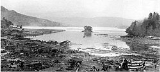
| 8.5 ML | 1896 Meiji-Sanriku earthquake 1896 Meiji-Sanriku earthquake The 1896 Meiji-Sanriku earthquake was highly destructive, generating one of the most devastating tsunamis in Japanese history, destroying about 9,000 homes and causing at least 22,000 deaths. This magnitude 7.2 event occurred at 19:32 on June 15, 1896... |
明治三陸地震 | Meiji-Sanriku Jishin | 22,000+ | This quake occurred off the coast of Sanriku in Iwate Prefecture Iwate Prefecture is the second largest prefecture of Japan after Hokkaido. It is located in the Tōhoku region of Honshū island and contains the island's easternmost point. The capital is Morioka. Iwate has the lowest population density of any prefecture outside Hokkaido... , causing a tsunami Tsunami A tsunami is a series of water waves caused by the displacement of a large volume of a body of water, typically an ocean or a large lake... of 25 m (82 ft) 35 minutes after the quake which destroyed hundreds of houses and killed over 22,000 people. Tsunami were also observed in Hawaii and in California. |
||
| 8.3 ML | 1923 Great Kantō earthquake 1923 Great Kanto earthquake The struck the Kantō plain on the Japanese main island of Honshū at 11:58:44 am JST on September 1, 1923. Varied accounts hold that the duration of the earthquake was between 4 and 10 minutes... |
大正関東地震(関東大震災) | Taishō Kantō Jishin(Kantō Daishinsai) | Izu Ōshima Izu Oshima is a volcanic island in the Izu Islands and administered by the Tokyo Metropolitan government, Japan, lies about 100 km south of Tokyo, 22 km east of the Izu Peninsula and 36 km southwest of Bōsō Peninsula. serves as the local government of the island... |
142,800 | An earthquake which struck the Kantō plain on the Japan Japan Japan is an island nation in East Asia. Located in the Pacific Ocean, it lies to the east of the Sea of Japan, China, North Korea, South Korea and Russia, stretching from the Sea of Okhotsk in the north to the East China Sea and Taiwan in the south... ese main island of Honshū Honshu is the largest island of Japan. The nation's main island, it is south of Hokkaido across the Tsugaru Strait, north of Shikoku across the Inland Sea, and northeast of Kyushu across the Kanmon Strait... at 11:58 on the morning of September 1, 1923. Varied accounts hold that the duration of the earthquake was between 4 and 10 minutes. The quake had an epicenter deep beneath Izu Ōshima Izu Oshima is a volcanic island in the Izu Islands and administered by the Tokyo Metropolitan government, Japan, lies about 100 km south of Tokyo, 22 km east of the Izu Peninsula and 36 km southwest of Bōsō Peninsula. serves as the local government of the island... Island in Sagami Bay Sagami Bay Sagami Bay , also known as the Sagami Gulf or Sagami Sea, lies south of Kanagawa Prefecture in Honshū, central Japan, contained within the scope of the Miura Peninsula, in Kanagawa, to the east, the Izu Peninsula, in Shizuoka Prefecture, to the west, and the Shōnan coastline to the north, while the... . It devastated Tokyo Tokyo , ; officially , is one of the 47 prefectures of Japan. Tokyo is the capital of Japan, the center of the Greater Tokyo Area, and the largest metropolitan area of Japan. It is the seat of the Japanese government and the Imperial Palace, and the home of the Japanese Imperial Family... , the port city of Yokohama Yokohama is the capital city of Kanagawa Prefecture and the second largest city in Japan by population after Tokyo and most populous municipality of Japan. It lies on Tokyo Bay, south of Tokyo, in the Kantō region of the main island of Honshu... , surrounding prefectures of Chiba Chiba Prefecture is a prefecture of Japan located in the Kantō region and the Greater Tokyo Area. Its capital is Chiba City.- History :Chiba Prefecture was established on June 15, 1873 with the merger of Kisarazu Prefecture and Inba Prefecture... , Kanagawa Kanagawa Prefecture is a prefecture located in the southern Kantō region of Japan. The capital is Yokohama. Kanagawa is part of the Greater Tokyo Area.-History:The prefecture has some archaeological sites going back to the Jōmon period... , and Shizuoka Shizuoka Prefecture is a prefecture of Japan located in the Chūbu region on Honshu island. The capital is the city of Shizuoka.- History :Shizuoka prefecture was formed from the former Tōtōmi, Suruga and Izu provinces.The area was the home of the first Tokugawa Shogun... , and caused widespread damage throughout the Kantō region. The power and intensity of the earthquake is easy to underestimate, but the 1923 earthquake managed to move the 93-ton Great Buddha Kotoku-in is a Buddhist temple of the Jōdo-shū sect in the city of Kamakura in Kanagawa Prefecture, Japan.The temple is renowned for its , a monumental outdoor bronze statue of Amida Buddha which is one of the most famous icons of Japan.- The Great Buddha :... statue at Kamakura Kamakura, Kanagawa is a city located in Kanagawa Prefecture, Japan, about south-south-west of Tokyo. It used to be also called .Although Kamakura proper is today rather small, it is often described in history books as a former de facto capital of Japan as the seat of the Shogunate and of the Regency during the... . The statue slid forward almost two feet. Casualty estimates range from about 142,800 deaths, the latter figure including approximately 40,000 who went missing and were presumed dead. |
|
| 7.6 ML | 1927 Kita Tango Earthquake | 北丹後地震 | Kita Tango Jishin | Tango Peninsula in Kyoto Prefecture Kyoto Prefecture is a prefecture of Japan located in the Kansai region of the island of Honshu. The capital is the city of Kyoto.- History :Until the Meiji Restoration, the area of Kyoto prefecture was known as Yamashiro.... |
3,020 | Almost all houses in Mineyama (now part of Kyōtango Kyotango, Kyoto is a city in Kyoto Prefecture, Japan. It was formed on April 1, 2004 by the merger of the towns of Mineyama and Omiya, both from Naka District,the towns of Amino, Tango and Yasaka, all from Takeno District, and the town of Kumihama, from Kumano District... ) were destroyed, and the quake was felt as far away as Tokyo Tokyo , ; officially , is one of the 47 prefectures of Japan. Tokyo is the capital of Japan, the center of the Greater Tokyo Area, and the largest metropolitan area of Japan. It is the seat of the Japanese government and the Imperial Palace, and the home of the Japanese Imperial Family... and Kagoshima. |
|
| 8.4 Mw | 1933 Sanriku earthquake 1933 Sanriku earthquake The was a major earthquake whose associated tsunami caused widespread damage to towns on the Sanriku coast of the Tōhoku region of Honshū, Japan on March 2, 1933.-History:The epicenter of the 1933 Sanriku earthquake was located offshore,... |
昭和三陸地震 | Shōwa Sanriku Jishin | 290 km (180.2 mi) east of the city of Kamaishi, Iwate Kamaishi, Iwate is a small, historic city located on the Sanriku rias coast of Iwate, Japan. As of 2008, the city has an estimated population of 41,022 and a density of 92.9 persons per km². The total area is 441.42 km². It is famous in modern times for its steel production and most recently for its promotion... |
3,000+ | 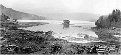 Earthquake An earthquake is the result of a sudden release of energy in the Earth's crust that creates seismic waves. The seismicity, seismism or seismic activity of an area refers to the frequency, type and size of earthquakes experienced over a period of time... whose associated tsunami Tsunami A tsunami is a series of water waves caused by the displacement of a large volume of a body of water, typically an ocean or a large lake... caused widespread damage to towns on the Sanriku Iwate Prefecture is the second largest prefecture of Japan after Hokkaido. It is located in the Tōhoku region of Honshū island and contains the island's easternmost point. The capital is Morioka. Iwate has the lowest population density of any prefecture outside Hokkaido... coast of the Tōhoku region Tohoku region The is a geographical area of Japan. The region occupies the northeastern portion of Honshu, the largest island of Japan. The region consists of six prefectures : Akita, Aomori, Fukushima, Iwate, Miyagi and Yamagata.... of Honshū Honshu is the largest island of Japan. The nation's main island, it is south of Hokkaido across the Tsugaru Strait, north of Shikoku across the Inland Sea, and northeast of Kyushu across the Kanmon Strait... , Japan Japan Japan is an island nation in East Asia. Located in the Pacific Ocean, it lies to the east of the Sea of Japan, China, North Korea, South Korea and Russia, stretching from the Sea of Okhotsk in the north to the East China Sea and Taiwan in the south... in 1933. |
|
| 7.2 ML | 1943 Tottori earthquake 1943 Tottori earthquake The was an earthquake which occurred in Tottori prefecture, Japan at 17:36 local time on September 10, 1943. Although the earthquake occurred during World War II, information about the disaster was surprisingly uncensored, and relief volunteers and supplies came from many parts of the Japanese... |
鳥取地震 | Tottori Jishin | offshore from Ketaka District Ketaka District, Tottori Ketaka was a district located in Tottori Prefecture, Japan.As of 2003, the district had an estimated population of 22,283 and a density of 143.75 persons per km². The total area was 155.01 km².-Former towns and villages:* Aoya* Ketaka... |
1,083 | An earthquake which occurred in Tottori prefecture Tottori Prefecture is a prefecture of Japan located in the Chūgoku region. The capital is the city of Tottori. It is the least populous prefecture in Japan.- History :Before the Meiji Restoration, Tottori encompassed the old provinces of Hōki and Inaba... , Japan Japan Japan is an island nation in East Asia. Located in the Pacific Ocean, it lies to the east of the Sea of Japan, China, North Korea, South Korea and Russia, stretching from the Sea of Okhotsk in the north to the East China Sea and Taiwan in the south... at 17:36 on September 10, 1943. Although the earthquake occurred during World War II World War II World War II, or the Second World War , was a global conflict lasting from 1939 to 1945, involving most of the world's nations—including all of the great powers—eventually forming two opposing military alliances: the Allies and the Axis... , information about the disaster was surprisingly uncensored, and relief volunteers and supplies came from many parts of the Japanese empire, including Manchukuo Manchukuo Manchukuo or Manshū-koku was a puppet state in Manchuria and eastern Inner Mongolia, governed under a form of constitutional monarchy. The region was the historical homeland of the Manchus, who founded the Qing Empire in China... . The Tottori earthquake had its epicenter Epicenter The epicenter or epicentre is the point on the Earth's surface that is directly above the hypocenter or focus, the point where an earthquake or underground explosion originates... offshore from Ketaka District Ketaka District, Tottori Ketaka was a district located in Tottori Prefecture, Japan.As of 2003, the district had an estimated population of 22,283 and a density of 143.75 persons per km². The total area was 155.01 km².-Former towns and villages:* Aoya* Ketaka... , now part of Tottori city Tottori, Tottori is the capital city of Tottori Prefecture in the Chūgoku region of Japan.As of 2006, the city has an estimated population of 200,974 and a density of 262.48 persons per km². The total area is 765.66 km².... with a magnitude of 7.2 on the Richter Scale Richter magnitude scale The expression Richter magnitude scale refers to a number of ways to assign a single number to quantify the energy contained in an earthquake.... . The magnitude of the earthquake was 6.0 in Tottori city, and 5.0 as far away as Okayama Okayama, Okayama is the capital city of Okayama Prefecture in the Chūgoku region of Japan.The city was founded on June 1, 1889. As of August 2010, the city has an estimated population of 705,224 and a population density of 893 persons per km². The total area is 789.88 km².... on the Inland Sea. |
|
| 8.1 | 1944 Tōnankai earthquake 1944 Tōnankai earthquake The 1944 Tōnankai earthquake occurred at 13:35 local time on 7 December. It had an estimated magnitude of 8.1 on the moment magnitude scale and a maximum felt intensity of greater than 5 shindo . It triggered a large tsunami that caused serious damage along the coast of Wakayama Prefecture and the... |
昭和東南海地震 | Tōnankai Jishin | 34.0°N 137.1°W | 1,223 | That this earthquake Dec. 7, 1944 13:35 local time (04:35 UTC) occurred in It is the moment magnitude Magnitude Magnitude Is A Part Of An EarthquakesMagnitude may refer to:In mathematics:*Magnitude , the relative size of a mathematical object*Magnitude , a term for the size or length of a vector... scale of the expected size of 8.1 and a maximum intensity of 5 or Shinto (Mercalli scale intensity VIII (Destruction) for), I felt. It is the province along the coast of the Tokai region Tokai region The is a sub-region of the Chūbu region in Japan that runs along the Pacific Ocean. The name means "East sea" and comes from the Tōkaidō, one of the Edo Five Routes... causing serious damage and triggered a tsunami. The earthquake Earthquake An earthquake is the result of a sudden release of energy in the Earth's crust that creates seismic waves. The seismicity, seismism or seismic activity of an area refers to the frequency, type and size of earthquakes experienced over a period of time... and tsunami Tsunami A tsunami is a series of water waves caused by the displacement of a large volume of a body of water, typically an ocean or a large lake... along the 1,223 people killed or injured has caused 20,000 people or more. |
|
| 6.8 | 1945 Mikawa earthquake 1945 Mikawa earthquake The was an earthquake which occurred off Aichi prefectures, Japan at 0338 AM on January 13, 1945. As the earthquake occurred during World War II, information about the disaster was censored, and efforts at keeping the disaster secret hampered relief efforts and contributed to a high death toll.... |
三河地震 | Mikawa Jishin | Mikawa Bay Mikawa Bay thumb|right|Mikawa Bay Mikawa Bay is a bay to the south of Aichi Prefecture, Japan, surrounded by Chita Peninsula to the west and Atsumi Peninsula to the east and south. Its area is approximately 604 km2... |
1180 + 1126 missing | An earthquake which occurred off Mie Mie Prefecture is a prefecture of Japan which is part of the Kansai regions on Honshū island. The capital is the city of Tsu.- History :Until the Meiji Restoration, Mie prefecture was known as Ise Province and Iga Province.... and Aichi prefecture Aichi Prefecture is a prefecture of Japan located in the Chūbu region. The region of Aichi is also known as the Tōkai region. The capital is Nagoya. It is the focus of the Chūkyō Metropolitan Area.- History :... s, Japan Japan Japan is an island nation in East Asia. Located in the Pacific Ocean, it lies to the east of the Sea of Japan, China, North Korea, South Korea and Russia, stretching from the Sea of Okhotsk in the north to the East China Sea and Taiwan in the south... at 03:38 on January 13, 1945. As the earthquake occurred during World War II World War II World War II, or the Second World War , was a global conflict lasting from 1939 to 1945, involving most of the world's nations—including all of the great powers—eventually forming two opposing military alliances: the Allies and the Axis... , information about the disaster was censored, and efforts at keeping the disaster secret hampered relief efforts and contributed to a high death toll. The Mikawa earthquake had its epicenter Epicenter The epicenter or epicentre is the point on the Earth's surface that is directly above the hypocenter or focus, the point where an earthquake or underground explosion originates... offshore in Mikawa Bay Mikawa Bay thumb|right|Mikawa Bay Mikawa Bay is a bay to the south of Aichi Prefecture, Japan, surrounded by Chita Peninsula to the west and Atsumi Peninsula to the east and south. Its area is approximately 604 km2... (34°42.1′N 137°6.8′E at a depth of eleven kilometers). The city of Tsu Tsu, Mie is the capital of Mie Prefecture, Japan. The city of Tsu is located on Ise Bay, east of the city. Tsu is bounded to the north by Suzuka and Kameyama; to the west by Iga, Nabari, and Nara Prefecture; and to the south by Matsuzaka city.-History:... recorded a magnitude of 6 on the Richter Scale Richter magnitude scale The expression Richter magnitude scale refers to a number of ways to assign a single number to quantify the energy contained in an earthquake.... ; however areas in southern Aichi prefecture were closer to the epicenter, and suffered significant damage. |
|
| 8.1 Mw | 1946 Nankaidō earthquake 1946 Nankaido earthquake The 1946 Nankaidō earthquake was a great earthquake in Nankaidō, Japan. It occurred on December 20, 1946 at 19:19 UTC. The earthquake measured between 8.1 and 8.4 on the moment magnitude scale, and was felt from Northern Honshū to Kyūshū... |
昭和南海地震 | Shōwa Nankai Jishin | Nankai Trough Nankai Trough The Nankai Trough is a submarine trough located south of Japan's island of Honshū, extending approximately 900 km offshore. In plate tectonics, the Nankai Trough marks a subduction zone that is caused by subduction of the Philippine Sea Plate beneath Japan, part of the Eurasian plate... |
1,362 | A major earthquake Earthquake An earthquake is the result of a sudden release of energy in the Earth's crust that creates seismic waves. The seismicity, seismism or seismic activity of an area refers to the frequency, type and size of earthquakes experienced over a period of time... in Nankaidō Nankaido The , literally meaning "southern sea road," is a Japanese term denoting both an ancient division of the country and the main road running through it. The road connected provincial capitals in this region... , Japan Japan Japan is an island nation in East Asia. Located in the Pacific Ocean, it lies to the east of the Sea of Japan, China, North Korea, South Korea and Russia, stretching from the Sea of Okhotsk in the north to the East China Sea and Taiwan in the south... . It occurred on December 20, 1946 at 19:19 UTC. The earthquake was felt from Northern Honshū Honshu is the largest island of Japan. The nation's main island, it is south of Hokkaido across the Tsugaru Strait, north of Shikoku across the Inland Sea, and northeast of Kyushu across the Kanmon Strait... to Kyūshū Kyushu is the third largest island of Japan and most southwesterly of its four main islands. Its alternate ancient names include , , and . The historical regional name is referred to Kyushu and its surrounding islands.... . |
|
| 7.1 Mw | 1948 Fukui earthquake 1948 Fukui earthquake The was a major earthquake in Fukui Prefecture, Japan. The magnitude 7.3 quake struck at 5:13 p.m. on June 28, 1948 . The strongest shaking occurred in the city of Fukui, where it was recorded as 6 on the Japan Meteorological Agency seismic intensity scale... |
福井地震 | Fukui Jishin | near Maruoka, Fukui Maruoka, Fukui was a town located in Sakai District, Fukui, Japan.On March 20, 2006 Maruoka, the towns of Harue, Mikuni and Sakai were merged to form the new city of Sakai.... |
3,769 | A major earthquake Earthquake An earthquake is the result of a sudden release of energy in the Earth's crust that creates seismic waves. The seismicity, seismism or seismic activity of an area refers to the frequency, type and size of earthquakes experienced over a period of time... in Fukui Prefecture Fukui Prefecture is a prefecture of Japan located in the Chūbu region on Honshū island. The capital is the city of Fukui.- Prehistory :The Kitadani Dinosaur Quarry, on the Sugiyama River within the city limits of Katsuyama, has yielded the Fukuiraptor kitadaniensis and Fukuisaurus tetoriensis as well as an unnamed... , Japan Japan Japan is an island nation in East Asia. Located in the Pacific Ocean, it lies to the east of the Sea of Japan, China, North Korea, South Korea and Russia, stretching from the Sea of Okhotsk in the north to the East China Sea and Taiwan in the south... . It struck at 5:13 p.m. on June 28, 1948 (the then Japan Daylight Saving Time; JDT). The strongest shaking occurred in the city of Fukui Fukui, Fukui is the capital of Fukui Prefecture, Japan. The city is located in the north-central part of the prefecture on the coast of the Sea of Japan.-Demographics:... , where it was recorded as 6 (equivalent to the current 7) on the Japan Meteorological Agency seismic intensity scale Japan Meteorological Agency seismic intensity scale The Japan Meteorological Agency seismic intensity scale is a seismic scale used in Japan and Taiwan to measure the intensity of earthquakes. It is measured in units of... . The coordinates of the earthquake were 36゜10.3'N 136゜17.4'E (around the town of Maruoka Maruoka, Fukui was a town located in Sakai District, Fukui, Japan.On March 20, 2006 Maruoka, the towns of Harue, Mikuni and Sakai were merged to form the new city of Sakai.... ). |
|
| 8.1 Mw | 1952 Hokkaido earthquake 1952 Hokkaido earthquake The 1952 Hokkaido Earthquake, which occurred on 4 March 1952 in the sea near Tokachi District, Hokkaidō, had a magnitude of 8.1 on the Richter Scale.-Damage:... |
1952年十勝沖地震 | 1952 Hokkaido Jishin | 42.3°N 144.9°W | 28 | 1952 Hokkaido earthquake is earthquake Earthquake An earthquake is the result of a sudden release of energy in the Earth's crust that creates seismic waves. The seismicity, seismism or seismic activity of an area refers to the frequency, type and size of earthquakes experienced over a period of time... that occur around March 4, 1952 in the Hokkaido Hokkaido , formerly known as Ezo, Yezo, Yeso, or Yesso, is Japan's second largest island; it is also the largest and northernmost of Japan's 47 prefectural-level subdivisions. The Tsugaru Strait separates Hokkaido from Honshu, although the two islands are connected by the underwater railway Seikan Tunnel... east sea.Scale is 8.1Mw. Casualties were due to an earthquake occurs. |
|
| 7.6 Mw | 1964 Niigata earthquake 1964 Niigata earthquake The 1964 Niigata earthquake struck at 13:01 local time on 16 June. The epicenter was on the continental shelf off the northwest coast of Honshu in Niigata Prefecture, about 50 km north of the city of Niigata... |
新潟地震 | Niigata Jishin | 50 km north of Niigata Niigata, Niigata is the capital and the most populous city of Niigata Prefecture, Japan. It lies on the northwest coast of Honshu, the largest island of Japan, and faces the Sea of Japan and Sado Island.... |
26 | The earthquake caused widespread soil liquefaction Soil liquefaction Soil liquefaction describes a phenomenon whereby a saturated soil substantially loses strength and stiffness in response to an applied stress, usually earthquake shaking or other sudden change in stress condition, causing it to behave like a liquid.... in the city of Niigata resulting in high levels of damage to buildings for the felt intensity. |
|
| 7.5 Mw | 1968 Hyūga-nada earthquake 1968 Hyūga-nada earthquake The 1968 Hyūga-nada earthquake occurred on April 1, 1968 at 09:42 local time . The earthquake had a magnitude of Mw 7.5, and the epicenter was located in Hyūga-nada Sea, off the islands of Kyushu and Shikoku, Japan. The magnitude of this earthquake was also given as Mjma 7.5. A tsunami was... |
1968年日向灘地震 | Sen-kyūhyaku-rokujūhachi-nen Hyūga-nada Jishin | Hyūga-nada Sea | |||
| 8.2 Mw | 1968 Aomori earthquake | 1968年十勝沖地震 | Sen-kyūhyaku-rokujūhachi-nen Tokachi-oki Jishin | Offshore of Misawa, Japan | 52 | This earthquake struck off the coast of Honshu Island, near Misawa Japan, Aomori Prefecture Aomori Prefecture is a prefecture of Japan located in the Tōhoku Region. The capital is the city of Aomori.- History :Until the Meiji Restoration, the area of Aomori prefecture was known as Mutsu Province.... and was followed by a significant tsunami. The earthquake and ensuing tsunami claimed 52 lives and resulted in significant material damage in Northern Japan. |
|
| 7.7 Ms | 1978 Miyagi earthquake 1978 Miyagi earthquake The occurred at 17:14 local time on 12 June. It had a magnitude of 7.7, JMA magnitude 7.4, and triggered a small tsunami. The earthquake reached a maximum intensity of Shindo 5 in Sendai and caused 28 deaths and 1,325 injuries.-Geology:... |
宮城県沖地震 | Miyagi-ken-oki jishin | just offshore Miyagi Prefecture Miyagi Prefecture is a prefecture of Japan in the Tōhoku Region on Honshu island. The capital is Sendai.- History :Miyagi Prefecture was formerly part of the province of Mutsu. Mutsu Province, on northern Honshu, was one of the last provinces to be formed as land was taken from the indigenous Emishi, and became the... |
28 | Damage was greatest around Sendai and the earthquake triggered widespread landslides. | |
| 7.7 Mw | 1994 offshore Sanriku earthquake 1994 offshore Sanriku earthquake The 1994 offshore Sanriku earthquake occurred on December 28, 1994 at 12:19 UTC . This was a magnitude Mw 7.7 earthquake with epicenter located in the Pacific Ocean at about 180 km east of Hachinohe, Aomori... |
三陸はるか沖地震 | offshore Sanriku jishin | 40.451°N 143.491°E | 3 | ||
| 7.2 Mw | Great Hanshin Earthquake Great Hanshin earthquake The Great Hanshin earthquake, or Kobe earthquake, was an earthquake that occurred on Tuesday, January 17, 1995, at 05:46 JST in the southern part of Hyōgo Prefecture, Japan. It measured 6.8 on the moment magnitude scale , and Mj7.3 on JMA magnitude scale. The tremors lasted for approximately 20... |
兵庫県南部地震(阪神・淡路大震災) | Hyōgoken Nanbu Jishin(Hanshin-Awaji Daishinsai ) | northern end of Awaji Island Awaji Island is an island in Hyōgo Prefecture, Japan, in the eastern part of the Seto Inland Sea between the islands of Honshū and Shikoku. The island has an area of 592.17 km²... |
6,434 | An earthquake Earthquake An earthquake is the result of a sudden release of energy in the Earth's crust that creates seismic waves. The seismicity, seismism or seismic activity of an area refers to the frequency, type and size of earthquakes experienced over a period of time... in Japan that occurred on Tuesday January 17, 1995 at 05:46 JST Japan Standard Time Japan Standard Time or JST is the standard timezone of Japan, and is 9 hours ahead of UTC. For example, when it is midnight in UTC, it is 09:00 in Japan Standard Time. There is no daylight saving time, though its introduction has been debated several times. Japan Standard Time is the same as... in the southern part of Hyōgo Prefecture Hyogo Prefecture is a prefecture of Japan located in the Kansai region on Honshū island. The capital is Kobe.The prefecture's name was previously alternately spelled as Hiogo.- History :... . It measured Mw 6.8 on the Moment magnitude scale Moment magnitude scale The moment magnitude scale is used by seismologists to measure the size of earthquakes in terms of the energy released. The magnitude is based on the seismic moment of the earthquake, which is equal to the rigidity of the Earth multiplied by the average amount of slip on the fault and the size of... (USGS United States Geological Survey The United States Geological Survey is a scientific agency of the United States government. The scientists of the USGS study the landscape of the United States, its natural resources, and the natural hazards that threaten it. The organization has four major science disciplines, concerning biology,... ), and Mj7.3 on the revised (7.2 on the old) JMA Japan Meteorological Agency The or JMA, is the Japanese government's weather service. Charged with gathering and reporting weather data and forecasts in Japan, it is a semi-autonomous part of the Ministry of Land, Infrastructure and Transport... magnitude scale. The tremors lasted for approximately 20 seconds. The hypocenter of the earthquake was located 16 km (9.9 mi) beneath its epicenter Epicenter The epicenter or epicentre is the point on the Earth's surface that is directly above the hypocenter or focus, the point where an earthquake or underground explosion originates... , on the northern end of Awaji Island Awaji Island is an island in Hyōgo Prefecture, Japan, in the eastern part of the Seto Inland Sea between the islands of Honshū and Shikoku. The island has an area of 592.17 km²... , 20 km (12.4 mi) away from the city of Kobe Kobe , pronounced , is the fifth-largest city in Japan and is the capital city of Hyōgo Prefecture on the southern side of the main island of Honshū, approximately west of Osaka... . |
|
| 7.5 Mw | 1998 Ryukyu Islands earthquake 1998 Ryukyu Islands earthquake The occurred on May 4, 1998 at 08:30 local time in the Philippine Sea region with Mw 7.5 and M7.7 . The epicenter was 260 km from Ishigaki Island, Japan, 400 km from Basco, Philippines, and 425 km from Hualian, Taiwan. A small local tsunami of 4 cm was observed on Miyako. The earthquake was... |
石垣島南方沖地震 | Ishigakijima nanpō-oki jishin | 22.30°N 125.30°E | 0 | The epicentre was in the Philippine Sea Philippine Sea The Philippine Sea is a marginal sea east and north of the Philippines occupying an estimated surface area of 2 million mi² on the western part of the North Pacific Ocean... and far off the coast (260km from Ishigaki Island, Japan Japan Japan is an island nation in East Asia. Located in the Pacific Ocean, it lies to the east of the Sea of Japan, China, North Korea, South Korea and Russia, stretching from the Sea of Okhotsk in the north to the East China Sea and Taiwan in the south... , 400 km from Basco Basco -Places:Philippines*Basco, Batanes, a municipality in the PhilippinesUnited States*Basco, Illinois, a village*Basco, Wisconsin, an unincorporated community... , Philippines Philippines The Philippines , officially known as the Republic of the Philippines , is a country in Southeast Asia in the western Pacific Ocean. To its north across the Luzon Strait lies Taiwan. West across the South China Sea sits Vietnam... , and 425 km from Hualian Hualian Hualian may refer to:*Hualian City, a city located in Hualian County, Taiwan, Republic of China*Hualian County, a county located in eastern Taiwan, Republic of China*Beijing Hualian, a company based in Beijing, People's Republic of China... , Taiwan Taiwan Taiwan , also known, especially in the past, as Formosa , is the largest island of the same-named island group of East Asia in the western Pacific Ocean and located off the southeastern coast of mainland China. The island forms over 99% of the current territory of the Republic of China following... ). |
|
| 8.3 Mw | 2003 Hokkaidō earthquake 2003 Hokkaido earthquake The 2003 Hokkaidō earthquake occurred on September 25, 2003 in Hokkaidō, Japan. It measured 8.3 on the Moment magnitude scale and caused extensive damage, destroying roads all around Hokkaidō, and caused several power outages and further damaging landslides. A number of people were injured... |
2003年十勝沖地震 | 2003 Hokkaidō Jishin | 41.78°N 143.86°E | 1 | 2003 earthquake in Hokkaido, Hokkaido, Japan on September 25, 2003 occurred. It is the moment magnitude scale measured 8.3, and extensive damage, destroying all the roads around Hokkaido, the cause of several power outages caused landslides further damage. | |
| 6.9 Mw | 2004 Chūetsu earthquake 2004 Chuetsu earthquake The occurred at 5:56 p.m. on Saturday, October 23, 2004 . The Japan Meteorological Agency has named it the Heisei 16 Niigata Prefecture Chuetsu Earthquake or The Mid Niigata Prefecture Earthquake of 2004... |
新潟県中越地震 | Chūetsu Jishin | Ojiya, Niigata Ojiya, Niigata is a city located in Niigata Prefecture, Japan.As of July 16, 2003, the city has an estimated population of 40,342. The total area is 155.12 km².-History:*The city was founded on March 10, 1954.... |
40 | Occurred at 5:56 p.m. (local time) on Saturday, October 23, 2004. The initial earthquake caused noticeable shaking across almost half of Honshū, including parts of the Tohoku Tohoku region The is a geographical area of Japan. The region occupies the northeastern portion of Honshu, the largest island of Japan. The region consists of six prefectures : Akita, Aomori, Fukushima, Iwate, Miyagi and Yamagata.... , Hokuriku Hokuriku region The is located in the northwestern part of Honshū, the main island of Japan. It lies along the Sea of Japan within the Chūbu region. It is almost equivalent to Koshi Province and Hokurikudō area in pre-modern Japan.... , Chūbu Chubu region The is the central region of Honshū, Japan's main island. Chūbu has a population estimate of 21,886,324 as of 2008.Chūbu, which means "central region", encompasses nine prefectures : Aichi, Fukui, Gifu, Ishikawa, Nagano, Niigata, Shizuoka, Toyama, Yamanashi, and often Mie.It is located directly... , and Kantō region Kanto region The is a geographical area of Honshu, the largest island of Japan. The region includes the Greater Tokyo Area and encompasses seven prefectures: Gunma, Tochigi, Ibaraki, Saitama, Tokyo, Chiba, and Kanagawa. Within its boundaries, slightly more than 40 percent of the land area is the Kantō Plain.... s. |
|
| 7.0 Mw | 2005 Fukuoka earthquake 2005 Fukuoka earthquake The Fukuoka earthquake struck Fukuoka Prefecture, Japan at 10:53 am JST on March 20, 2005, and lasted for approximately 1 minute. The Japan Meteorological Agency measured it as peaking at a magnitude of 7.0 and named it and its subsequent aftershocks the... |
福岡県西方沖地震 | Fukuoka-ken Seihō Oki Jishin | In the Genkai Sea Genkai Sea The is a body of water that comprises the southwestern tip of the Sea of Japan and borders the northern coasts of Fukuoka and Saga prefectures.... about 6 km (3.7 mi) northwest of Genkai Island at the mouth of Fukuoka Harbor |
1 | This earthquake struck Fukuoka Prefecture Fukuoka Prefecture is a prefecture of Japan located on Kyūshū Island. The capital is the city of Fukuoka.- History :Fukuoka Prefecture includes the former provinces of Chikugo, Chikuzen, and Buzen.... , Japan Japan Japan is an island nation in East Asia. Located in the Pacific Ocean, it lies to the east of the Sea of Japan, China, North Korea, South Korea and Russia, stretching from the Sea of Okhotsk in the north to the East China Sea and Taiwan in the south... at 10:53:40 JST Japan Standard Time Japan Standard Time or JST is the standard timezone of Japan, and is 9 hours ahead of UTC. For example, when it is midnight in UTC, it is 09:00 in Japan Standard Time. There is no daylight saving time, though its introduction has been debated several times. Japan Standard Time is the same as... on March 20 (the week before Easter Sunday) and lasted for approximately 50 seconds. The quake occurred along a previously unknown fault in the Genkai Sea, North of Fukuoka Fukuoka, Fukuoka is the capital city of Fukuoka Prefecture and is situated on the northern shore of the island of Kyushu in Japan.Voted number 14 in a 2010 poll of the World's Most Livable Cities, Fukuoka is praised for its green spaces in a metropolitan setting. It is the most populous city in Kyushu, followed by... city, and the residents of Genkai Island were forced to evacuate as houses collapsed and landslides occurred in places. Investigations subsequent to the earthquake determined that the new fault was most likely an extension of the known Kego faultline that runs through the center of the city. |
|
| 7.2 Mw | 2005 Miyagi earthquake 2005 Miyagi earthquake The 2005 Miyagi earthquake was a powerful earthquake that struck the east coast of the Japanese island of Honshū at 11.46am on August 16, causing casualties, building collapses and power outages.-Earthquake characteristics:... |
宮城県沖地震 | Miyagi-ken Oki Jishin | about 55 km (34.2 mi) due east of the Oshika Peninsula Oshika Peninsula The Oshika Peninsula is a peninsula which projects southeast into the Pacific Ocean from the coast of Miyagi Prefecture in northeast Honshu, the main island of Japan.... in Miyagi Prefecture Miyagi Prefecture is a prefecture of Japan in the Tōhoku Region on Honshu island. The capital is Sendai.- History :Miyagi Prefecture was formerly part of the province of Mutsu. Mutsu Province, on northern Honshu, was one of the last provinces to be formed as land was taken from the indigenous Emishi, and became the... |
0 | A powerful earthquake Earthquake An earthquake is the result of a sudden release of energy in the Earth's crust that creates seismic waves. The seismicity, seismism or seismic activity of an area refers to the frequency, type and size of earthquakes experienced over a period of time... that struck the east coast of the Japan Japan Japan is an island nation in East Asia. Located in the Pacific Ocean, it lies to the east of the Sea of Japan, China, North Korea, South Korea and Russia, stretching from the Sea of Okhotsk in the north to the East China Sea and Taiwan in the south... ese island of Honshū Honshu is the largest island of Japan. The nation's main island, it is south of Hokkaido across the Tsugaru Strait, north of Shikoku across the Inland Sea, and northeast of Kyushu across the Kanmon Strait... at 11:46 (02:46 UTC) on August 16, causing casualties, building collapses and power outage Power outage A power outage is a short- or long-term loss of the electric power to an area.There are many causes of power failures in an electricity network... s. The earthquake began on Tuesday, August 16, 2005, and affected Japan's northeastern coast. It triggered a tsunami warning, and buildings shook 200 miles away in the capital, Tokyo. It was initially estimated to have a rating of 6.8., and the U.S. Geological Survey later registered it as a 7.2. |
|
| 8.3 Mw | 2006 Kuril Islands earthquake 2006 Kuril Islands earthquake The 2006 Kuril Islands earthquake was an 8.3 magnitude earthquake that hit the Kuril Islands at 11:14 UTC on November 15, 2006. A small tsunami hit the Japanese northern coast, with a larger wave following earlier small ones, due to reflection. The tsunami crossed the Pacific and did damage in... |
2006年千島列島沖地震 | Chishima Rettō Oki Jishin | about 160 km (99.4 mi) due east of the southern tip of Simushir Simushir Simushir is an uninhabited volcanic island near the center of the Kuril Islands chain in the Sea of Okhotsk in the northwest Pacific Ocean. Its name is derived from the Ainu language for “large island”.-Geology:... in the Kuril Islands Kuril Islands The Kuril Islands , in Russia's Sakhalin Oblast region, form a volcanic archipelago that stretches approximately northeast from Hokkaidō, Japan, to Kamchatka, Russia, separating the Sea of Okhotsk from the North Pacific Ocean. There are 56 islands and many more minor rocks. It consists of Greater... |
0 | The earthquake happened at 20:29 JST Japan Standard Time Japan Standard Time or JST is the standard timezone of Japan, and is 9 hours ahead of UTC. For example, when it is midnight in UTC, it is 09:00 in Japan Standard Time. There is no daylight saving time, though its introduction has been debated several times. Japan Standard Time is the same as... on November 15, 2006, causing a tsunami Tsunami A tsunami is a series of water waves caused by the displacement of a large volume of a body of water, typically an ocean or a large lake... to hit the Japanese northern coast. |
|
| 8.1 Mw | 2007 Kuril Islands earthquake 2007 Kuril Islands earthquake The 2007 Kuril Islands earthquake was a great earthquake that occurred east of the Kuril Islands on January 13, 2007 at 1:23 p.m. JST with a magnitude of 8.1 Mw. A tsunami warning was issued following the earthquake, and sea level gauges indicate that a tsunami was generated... |
2007年千島列島沖地震 | 46°28.8′N 154°04.48′E | 0 | The earthquake happened at 1:23 p.m. JST Japan Standard Time Japan Standard Time or JST is the standard timezone of Japan, and is 9 hours ahead of UTC. For example, when it is midnight in UTC, it is 09:00 in Japan Standard Time. There is no daylight saving time, though its introduction has been debated several times. Japan Standard Time is the same as... (04:23 UTC Coordinated Universal Time Coordinated Universal Time is the primary time standard by which the world regulates clocks and time. It is one of several closely related successors to Greenwich Mean Time. Computer servers, online services and other entities that rely on having a universally accepted time use UTC for that purpose... ) and resulted in a tsunami Tsunami A tsunami is a series of water waves caused by the displacement of a large volume of a body of water, typically an ocean or a large lake... warning but did not cause significant damage. The epicentre was located 95 km to the south east of the 2006 Kuril Islands earthquake 2006 Kuril Islands earthquake The 2006 Kuril Islands earthquake was an 8.3 magnitude earthquake that hit the Kuril Islands at 11:14 UTC on November 15, 2006. A small tsunami hit the Japanese northern coast, with a larger wave following earlier small ones, due to reflection. The tsunami crossed the Pacific and did damage in... that struck a few weeks earlier. |
||
| 6.9 Mw | Noto Peninsula Earthquake | 能登半島地震 | Noto Hantō Jishin | about 11 km (6.8 mi) due west of the southern end of the town of Wajima Wajima, Ishikawa is a city located in Ishikawa, Japan.As of 2008, the city has an estimated population of 31,532 and the density of 74 persons per km². The total area is 426.25 km².The city was founded on March 31, 1954.... |
1 | At 9:42 a.m., a magnitude Richter magnitude scale The expression Richter magnitude scale refers to a number of ways to assign a single number to quantify the energy contained in an earthquake.... 6.9 earthquake Earthquake An earthquake is the result of a sudden release of energy in the Earth's crust that creates seismic waves. The seismicity, seismism or seismic activity of an area refers to the frequency, type and size of earthquakes experienced over a period of time... , struck the Hokuriku region Hokuriku region The is located in the northwestern part of Honshū, the main island of Japan. It lies along the Sea of Japan within the Chūbu region. It is almost equivalent to Koshi Province and Hokurikudō area in pre-modern Japan.... of Japan, near the Noto Peninsula Noto Peninsula thumb|right|240px|Landsat image with high-resolution data from Space Shuttle.Noto Peninsula is a peninsula that projects north into the Sea of Japan from the coast of Ishikawa prefecture in central Honshū, the main island of Japan... . The earthquake shook the city of Nanao Nanao, Ishikawa is a city located in Ishikawa prefecture, Japan.As of March 1, 2010, the city has an estimated population of 58,204 and a population density of 183 persons per km². Nanao is the fifth largest city by population in Ishikawa, behind Kanazawa, Hakusan, Komatsu, and Kaga.Nanao is situated in the... and the town of Anamizu Anamizu, Ishikawa is a town located in Hōsu District , Ishikawa, Japan.As of 2008, the town has an estimated population of 10,193 and a density of 55.63 persons per km². The total area is 183.24 km².... with a seismic intensity Japan Meteorological Agency seismic intensity scale The Japan Meteorological Agency seismic intensity scale is a seismic scale used in Japan and Taiwan to measure the intensity of earthquakes. It is measured in units of... of 6+ on Japan's shindo scale Japan Meteorological Agency seismic intensity scale The Japan Meteorological Agency seismic intensity scale is a seismic scale used in Japan and Taiwan to measure the intensity of earthquakes. It is measured in units of... . One death, in the city of Wajima Wajima, Ishikawa is a city located in Ishikawa, Japan.As of 2008, the city has an estimated population of 31,532 and the density of 74 persons per km². The total area is 426.25 km².The city was founded on March 31, 1954.... , and at least 214 injuries have been reported. A tsunami Tsunami A tsunami is a series of water waves caused by the displacement of a large volume of a body of water, typically an ocean or a large lake... advisory was immediately made for the Kaga Kaga, Ishikawa is a city located in the southwest of Ishikawa Prefecture, Japan.Created as an old temple town, the city was greatly developed by the Maeda clan in the early Edo period... coast and Noto coast, and a 10–20 cm wave hit shore about 30 minutes later. |
|
| 6.6 Mw | Chūetsu Offshore Earthquake | 新潟県中越沖地震 | Niigata-ken Chūetsu Oki Jishin | about 29 km (18 mi) west of Niigata Niigata, Niigata is the capital and the most populous city of Niigata Prefecture, Japan. It lies on the northwest coast of Honshu, the largest island of Japan, and faces the Sea of Japan and Sado Island.... |
11 | The earthquake) was a powerful magnitude Richter magnitude scale The expression Richter magnitude scale refers to a number of ways to assign a single number to quantify the energy contained in an earthquake.... 6.6 earthquake Earthquake An earthquake is the result of a sudden release of energy in the Earth's crust that creates seismic waves. The seismicity, seismism or seismic activity of an area refers to the frequency, type and size of earthquakes experienced over a period of time... that occurred 10:13 a.m. local time Japan Standard Time Japan Standard Time or JST is the standard timezone of Japan, and is 9 hours ahead of UTC. For example, when it is midnight in UTC, it is 09:00 in Japan Standard Time. There is no daylight saving time, though its introduction has been debated several times. Japan Standard Time is the same as... (01:13 UTC Coordinated Universal Time Coordinated Universal Time is the primary time standard by which the world regulates clocks and time. It is one of several closely related successors to Greenwich Mean Time. Computer servers, online services and other entities that rely on having a universally accepted time use UTC for that purpose... ) on July 16, 2007, in the northwest Niigata region Niigata Prefecture is a prefecture of Japan located on the island of Honshū on the coast of the Sea of Japan. The capital is the city of Niigata. The name "Niigata" literally means "new lagoon".- History :... of Japan. The earthquake shook Niigata and neighbouring prefectures. The city of Kashiwazaki Kashiwazaki, Niigata is a city located in Niigata, Japan.As of May 1, 2008, the city has an estimated population of 92,947 and the density of 210 persons per km². The total area is 442.70 km².... and the villages of Iizuna Iizuna, Nagano is a town located in the north side of Nagano City, Kamiminochi District, Nagano, Japan.The town was created through a merger of the villages of Samizu and Mure on October 1, 2005.... and Kariwa Kariwa, Niigata is a village located in Kariwa District, Niigata, Japan.As of March 31, 2007, the village has a population of 4,997 and a density of 190.14 persons per km²... registered the highest seismic intensity Japan Meteorological Agency seismic intensity scale The Japan Meteorological Agency seismic intensity scale is a seismic scale used in Japan and Taiwan to measure the intensity of earthquakes. It is measured in units of... of a strength 6 on Japan's shindo scale Japan Meteorological Agency seismic intensity scale The Japan Meteorological Agency seismic intensity scale is a seismic scale used in Japan and Taiwan to measure the intensity of earthquakes. It is measured in units of... , but the quake was felt as far away as Tokyo. Eleven deaths and at least 1,000 injuries have been reported, and 342 buildings were completely destroyed, mostly older wooden structures. |
|
| 6.9 Mw | 2008 Iwate-Miyagi Nairiku earthquake 2008 Iwate-Miyagi Nairiku earthquake The 2008 Iwate earthquake on June 14, 2008 mainly struck mid Tōhoku region, northeastern Honshū, Japan. Japan Meteorological Agency officially named this earthquake .... |
岩手・宮城内陸地震 | Iwate Miyagi Nairiku Jishin | about 1 km (0.621372736649807 mi) east of Narusawa Onsen in northwest Iwate Prefecture Iwate Prefecture is the second largest prefecture of Japan after Hokkaido. It is located in the Tōhoku region of Honshū island and contains the island's easternmost point. The capital is Morioka. Iwate has the lowest population density of any prefecture outside Hokkaido... |
12 | This earthquake struck mid Tōhoku region Tohoku region The is a geographical area of Japan. The region occupies the northeastern portion of Honshu, the largest island of Japan. The region consists of six prefectures : Akita, Aomori, Fukushima, Iwate, Miyagi and Yamagata.... , northeastern Honshū Honshu is the largest island of Japan. The nation's main island, it is south of Hokkaido across the Tsugaru Strait, north of Shikoku across the Inland Sea, and northeast of Kyushu across the Kanmon Strait... , Japan. |
|
| 6.9-7.1 Mw | 2009 Izu Islands earthquake 2009 Izu Islands earthquake The 2009 Izu Islands earthquake occurred on August 9, 2009 at 19:55 local time near the Izu Islands, off the south coast of Honshu. The epicenter was 170 km from Hamamatsu and 325 km from Tokyo.... |
33.144°N, 138.040°E, depth 303.1 km | 0 | ||||
| 6.5-6.6 Mw | Tokai Area Earthquake | 33.8°N, 138.50°E, depth 20.0 km | 1 | ||||
| 7.0 Mw | Ryūkyū Islands earthquake | 25.902°N, 128.417°E, depth 22.0 km | 1 | ||||
| 7.4 Mw | Bonin Islands earthquake 2010 Bonin Islands earthquake The 2010 Bonin Islands earthquake occurred on 21 December 2010 when a MW 7.4 earthquake struck off of the Bonin Islands, Japan.The quake occurred at about 0220 local time , about east of the Bonin Islands, at a depth of around... |
26.866°N, 143.739°E, depth 14.9 km | 0 | ||||
| 7.2 Mw | 2011 Tōhoku earthquake 2011 Tōhoku earthquake and tsunami The 2011 earthquake off the Pacific coast of Tohoku, also known as the 2011 Tohoku earthquake, or the Great East Japan Earthquake, was a magnitude 9.0 undersea megathrust earthquake off the coast of Japan that occurred at 14:46 JST on Friday, 11 March 2011, with the epicenter approximately east... foreshock |
東北地方太平洋沖地震(Foreshock Foreshock A foreshock is an earthquake that occurs before a larger seismic event and is related to it in both time and space. The designation of an earthquake as foreshock, mainshock or aftershock is only possible after the event.... )(東日本大震災) |
Tōhokuchihō Taiheiyō Oki Jishin(Higashi Nihon Dai-Shinsai) | 38.424°N, 142.836°E, depth 32 km | ? | ||
| 05:46:23 UTC (14:46 JST Japan Standard Time Japan Standard Time or JST is the standard timezone of Japan, and is 9 hours ahead of UTC. For example, when it is midnight in UTC, it is 09:00 in Japan Standard Time. There is no daylight saving time, though its introduction has been debated several times. Japan Standard Time is the same as... ) |
9.0 Mw | 2011 Tōhoku earthquake 2011 Tōhoku earthquake and tsunami The 2011 earthquake off the Pacific coast of Tohoku, also known as the 2011 Tohoku earthquake, or the Great East Japan Earthquake, was a magnitude 9.0 undersea megathrust earthquake off the coast of Japan that occurred at 14:46 JST on Friday, 11 March 2011, with the epicenter approximately east... |
東北地方太平洋沖地震(東日本大震災) | Tōhokuchihō Taiheiyō Oki Jishin(Higashi Nihon Dai-Shinsai) | 38.510°N, 142.792°E, depth 24.4 km | confirmed. |
This megathrust earthquake Megathrust earthquake Megathrust earthquakes occur at subduction zones at destructive plate boundaries , where one tectonic plate is forced under another. Due to the shallow dip of the plate boundary, which causes large sections to get stuck, these earthquakes are among the world's largest, with moment magnitudes ... 's hypocenter was reported to be off the Oshika Peninsula Oshika Peninsula The Oshika Peninsula is a peninsula which projects southeast into the Pacific Ocean from the coast of Miyagi Prefecture in northeast Honshu, the main island of Japan.... , the east coast of Tōhoku Tohoku region The is a geographical area of Japan. The region occupies the northeastern portion of Honshu, the largest island of Japan. The region consists of six prefectures : Akita, Aomori, Fukushima, Iwate, Miyagi and Yamagata.... It was the strongest to hit Japan and one of the top five largest earthquakes in the world since seismological record-keeping began. It was followed by a tsunami Tsunami A tsunami is a series of water waves caused by the displacement of a large volume of a body of water, typically an ocean or a large lake... with waves of up to 10 m (32.8 ft). The disaster left thousands dead and inflicted extensive material damage to buildings and infrastructure that led to significant accidents at four major nuclear power stations 2011 Japanese nuclear accidents This is a list of articles describing aspects of the nuclear shut-downs, failures, and nuclear meltdowns triggered by the 2011 Tōhoku earthquake and tsunami.-Fukushima nuclear power plants:* Fukushima I Nuclear Power Plant... . |
| 06:25:50 UTC |
7.1 Mw | 2011 Tōhoku earthquake 2011 Tōhoku earthquake and tsunami The 2011 earthquake off the Pacific coast of Tohoku, also known as the 2011 Tohoku earthquake, or the Great East Japan Earthquake, was a magnitude 9.0 undersea megathrust earthquake off the coast of Japan that occurred at 14:46 JST on Friday, 11 March 2011, with the epicenter approximately east... aftershock |
東北地方太平洋沖地震(Aftershock Aftershock An aftershock is a smaller earthquake that occurs after a previous large earthquake, in the same area of the main shock. If an aftershock is larger than the main shock, the aftershock is redesignated as the main shock and the original main shock is redesignated as a foreshock... )(東日本大震災) |
Tōhokuchihō Taiheiyō Oki Jishin(Higashi Nihon Dai-Shinsai) | 38.106°N, 144.553°E, depth 19.7 km | ||
| 23:30:00 JST Japan Standard Time Japan Standard Time or JST is the standard timezone of Japan, and is 9 hours ahead of UTC. For example, when it is midnight in UTC, it is 09:00 in Japan Standard Time. There is no daylight saving time, though its introduction has been debated several times. Japan Standard Time is the same as... |
7.1 Mw | 2011 Miyagi earthquake April 2011 Miyagi earthquake The April 2011 Miyagi earthquake was a magnitude 7.1 Mw earthquake, with an epicentre off the coast of Miyagi Prefecture, approximately east of Sendai, Japan... aftershock |
38.253°N, 141.640°E, depth 49 km | 4 | |||
| 17:16:13 JST Japan Standard Time Japan Standard Time or JST is the standard timezone of Japan, and is 9 hours ahead of UTC. For example, when it is midnight in UTC, it is 09:00 in Japan Standard Time. There is no daylight saving time, though its introduction has been debated several times. Japan Standard Time is the same as... |
6.6 Mw | 2011 Fukushima earthquake April 2011 Fukushima earthquake The was a potent magnitude 6.6 Mw intraplate aftershock that occurred at 17:16 JST on Monday, 11 April 2011. With a shallow focal depth of 10 km , it was centered inland about 36 km west of Iwaki, Japan, resulting in widespread moderate to localized strong shaking... aftershock |
福島県浜通り地震 | Fukushima-ken Hamadori Jishin | 37.007°N, 140.477°E, depth 10 km | 6 | |
| 10:57:12 JST Japan Standard Time Japan Standard Time or JST is the standard timezone of Japan, and is 9 hours ahead of UTC. For example, when it is midnight in UTC, it is 09:00 in Japan Standard Time. There is no daylight saving time, though its introduction has been debated several times. Japan Standard Time is the same as... |
7.0 Mw | 2011 Fukushima earthquake April 2011 Fukushima earthquake The was a potent magnitude 6.6 Mw intraplate aftershock that occurred at 17:16 JST on Monday, 11 April 2011. With a shallow focal depth of 10 km , it was centered inland about 36 km west of Iwaki, Japan, resulting in widespread moderate to localized strong shaking... aftershock |
38.040°N, 143.287°E,, depth 49 km | 0 | Quake was centered c. 212 km off the east coast of Sendai |
See also
- Seismicity in Japan
- Tokai earthquakesTokai earthquakesThe Tōkai earthquakes are major earthquakes that have occurred regularly with an interval of 100 to 150 years in the Tōkai region of Japan. The Tokai segment has been struck by earthquakes in 1498, 1605, 1707 and 1854...
- Tonankai earthquakes
- Nankai megathrust earthquakes
- Kanto earthquakeKanto earthquakecan refer to any of the historical earthquakes to occur in the Kantō region that originate from slippage in the Sagami Trough. Although the 1854 Ansei Great Earthquakes also struck in the region, this term is never used to refer to these quakes.It can refer to:...
- Seismicity of the Sanriku coast
- Tokai earthquakes
- Geology of JapanGeology of JapanThe islands of Japan are primarily the result of several large oceanic movements occurring over hundreds of millions of years from the mid-Silurian to the Pleistocene as a result of the subduction of the Philippine Sea Plate beneath the continental Amurian Plate and Okinawa Plate to the south, and...
- List of volcanoes in Japan
- Nuclear power in Japan#Seismicity
- Japan Meteorological AgencyJapan Meteorological AgencyThe or JMA, is the Japanese government's weather service. Charged with gathering and reporting weather data and forecasts in Japan, it is a semi-autonomous part of the Ministry of Land, Infrastructure and Transport...
- Japan Meteorological Agency seismic intensity scaleJapan Meteorological Agency seismic intensity scaleThe Japan Meteorological Agency seismic intensity scale is a seismic scale used in Japan and Taiwan to measure the intensity of earthquakes. It is measured in units of...
- Coordinating Committee for Earthquake PredictionCoordinating Committee for Earthquake PredictionThe Coordinating Committee for Earthquake Prediction in Japan was founded in April 1969, as part of the Geodesy Council's Second Earthquake Prediction Plan, in order to carry out a comprehensive evaluation of earthquake data in Japan. The committee consists of 30 members and meets four times each...