
List of California state parks
Encyclopedia
This is a list of parks and reserves in the California State Park system.
Jump to: External links

Jump to: External links
| Park name | Designation | County or counties |
Area in acres (ha) |
Year estab- lished |
Status | Remarks |
|---|---|---|---|---|---|---|
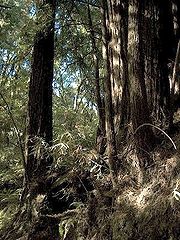
| Admiral William Standley State Recreation Area Admiral William Standley State Recreation Area Admiral William Standley State Recreation Area is a state recreation area of California, USA, featuring of redwoods on the Eel River. It is located west of Laytonville, California, in Mendocino County... |
State recreation area | Mendocino Mendocino County, California Mendocino County is a county located on the north coast of the U.S. state of California, north of the greater San Francisco Bay Area and west of the Central Valley. As of the 2010 census, the population was 87,841, up from 86,265 at the 2000 census... |
45 | 1944 | Features redwoods plus fishing for salmon Salmon Salmon is the common name for several species of fish in the family Salmonidae. Several other fish in the same family are called trout; the difference is often said to be that salmon migrate and trout are resident, but this distinction does not strictly hold true... and steelhead Rainbow trout The rainbow trout is a species of salmonid native to tributaries of the Pacific Ocean in Asia and North America. The steelhead is a sea run rainbow trout usually returning to freshwater to spawn after 2 to 3 years at sea. In other words, rainbow trout and steelhead trout are the same species.... on the Eel River Eel River (California) The Eel River is a major river system of the northern Pacific coast of the U.S. state of California. Approximately 200 miles long, it drains a rugged area in the California Coast Ranges between the Sacramento Valley and the ocean. For most of its course, the river flows northwest, parallel to the... . |
|
| Ahjumawi Lava Springs State Park Ahjumawi Lava Springs State Park Ahjumawi Lava Springs State Park is a state park of California, USA, preserving a wilderness of freshwater springs and geologically recent lava flows. Unique in the California state park system, public access is by boat only. It is located in Shasta County, California. The state acquired the... |
State park | Shasta Shasta County, California Shasta County is a county located in the northern portion of the U.S. state of California. The county occupies the northern reaches of the Sacramento Valley, with portions extending into the southern reaches of the Cascade Range. As of the 2010 census, the population was 177,223, up from 163,256... |
5,930 | 1975 | Preserves a wilderness of freshwater spring Spring (hydrosphere) A spring—also known as a rising or resurgence—is a component of the hydrosphere. Specifically, it is any natural situation where water flows to the surface of the earth from underground... s and geologically recent lava flows. |
|
| Albany State Marine Reserve | Park property | Alameda Alameda County, California Alameda County is a county in the U.S. state of California. It occupies most of the East Bay region of the San Francisco Bay Area. As of the 2010 census it had a population of 1,510,271, making it the 7th most populous county in the state... |
1985 | In development, not open to public | ||
| Anderson Marsh State Historic Park Anderson Marsh State Historic Park Anderson Marsh State Historic Park is a California State Historic Park and nature reserve preserving a tule marsh, archaeological sites of the Pomo people, and historic ranch structures. It is located in Lake County, California, USA... |
State historic park | Lake Lake County, California Lake County is a county located in the north central portion of the U.S. state of California, north of the San Francisco Bay Area. It takes its name from Clear Lake, the dominant geographic feature in the county and the largest natural lake wholly within California... |
1,298 | 1982 | Slated to close July 2012 | Preserves a tule marsh and ancient archaeological sites of the Pomo people Pomo people The Pomo people are an indigenous peoples of California. The historic Pomo territory in northern California was large, bordered by the Pacific Coast to the west, extending inland to Clear Lake, and mainly between Cleone and Duncans Point... . |
| Andrew Molera State Park Andrew Molera State Park Andrew Molera State Park is a state park of California, USA, preserving relatively undeveloped land on the Big Sur coast. Situated at the mouth of the Big Sur River, the property was part of the Rancho El Sur land grant, and later owned by the Cooper-Molera ranching family. The park is named in ... |
State park | Monterey Monterey County, California Monterey County is a county located on the Pacific coast of the U.S. state of California, its northwestern section forming the southern half of Monterey Bay. The northern half of the bay is in Santa Cruz County. As of 2010, the population was 415,057. The county seat and largest city is Salinas... |
4,766 | 1968 | Offers a primitive walk-in campground on the Big Sur Big Sur Big Sur is a sparsely populated region of the Central Coast of California where the Santa Lucia Mountains rise abruptly from the Pacific Ocean. The name "Big Sur" is derived from the original Spanish-language "el sur grande", meaning "the big south", or from "el país grande del sur", "the big... coast. |
|
| Angel Island State Park | State park | Marin Marin County, California Marin County is a county located in the North San Francisco Bay Area of the U.S. state of California, across the Golden Gate Bridge from San Francisco. As of 2010, the population was 252,409. The county seat is San Rafael and the largest employer is the county government. Marin County is well... and San Francisco |
756 | 1955 | Interprets an island in San Francisco Bay San Francisco Bay San Francisco Bay is a shallow, productive estuary through which water draining from approximately forty percent of California, flowing in the Sacramento and San Joaquin rivers from the Sierra Nevada mountains, enters the Pacific Ocean... whose history encompasses Coast Miwok Coast Miwok The Coast Miwok were the second largest group of Miwok Native American people. The Coast Miwok inhabited the general area of modern Marin County and southern Sonoma County in Northern California, from the Golden Gate north to Duncans Point and eastward to Sonoma Creek... prehistory, ranching, the 1910–1940 Angel Island Immigration Station United States Immigration Station, Angel Island Angel Island Immigration Station was an immigrant processing facility on Angel Island, in the San Francisco Bay. It opened in 1910 and is listed on the National Register of Historic Places. It is now the site of a museum. The museum and grounds were renovated and reopened to the public in February... , and long military use. |
|
| Annadel State Park Annadel State Park Annadel State Park is a state park of California, USA, situated at the northern edge of Sonoma Valley and offering many recreational activities within its property... |
State park | Sonoma Sonoma County, California Sonoma County, located on the northern coast of the U.S. state of California, is the largest and northernmost of the nine San Francisco Bay Area counties. Its population at the 2010 census was 483,878. Its largest city and county seat is Santa Rosa.... |
5,092 | 1971 | Slated to close July 2012 | Supports a variety of day-use activities at the northern end of Sonoma Valley Sonoma Valley Sonoma Valley is the birthplace of the California wine industry and often called The Valley of the Moon. Sonoma Valley is home to some of the earliest vineyards and wineries in the state, some of which survived the phylloxera epidemic of the 1870s and the impact of Prohibition... . |
| Año Nuevo State Park | State park | San Mateo San Mateo County, California San Mateo County is a county located in the San Francisco Bay Area of the U.S. state of California. It covers most of the San Francisco Peninsula just south of San Francisco, and north of Santa Clara County. San Francisco International Airport is located at the northern end of the county, and... |
4,209 | 1985 | Encompasses Año Nuevo Island Año Nuevo Island Año Nuevo Island is a small island off Año Nuevo Point on the coast of Northern California, between San Francisco and Santa Cruz. It is an important breeding site for Northern Elephant Seals and the endangered Steller's Sea Lion, as well as several species of seabirds, including Rhinoceros... and Año Nuevo Point, which boasts the world's largest mainland rookery of northern elephant seal Northern Elephant Seal The northern elephant seal is one of two species of elephant seal . It is a member of the family Phocidae . Elephant seals derive their name from their great size and from the male's large proboscis, which is used in making extraordinarily loud roaring noises, especially during the mating... s. |
|
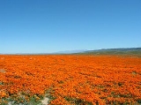
| Antelope Valley California Poppy Reserve Antelope Valley California Poppy Reserve Antelope Valley California Poppy Reserve is a state-protected reserve of California, USA, harboring the most consistent blooms of California poppies, the state flower. The reserve is located in the rural westside of Antelope Valley in northern Los Angeles County, west of Lancaster. The reserve... |
State natural reserve | Los Angeles Los Angeles County, California Los Angeles County is a county in the U.S. state of California. As of 2010 U.S. Census, the county had a population of 9,818,605, making it the most populous county in the United States. Los Angeles County alone is more populous than 42 individual U.S. states... |
1,781 | 1976 | Showcases the state's most-consistent blooms of California poppy California poppy The California poppy is a perennial and annual plant, native to the United States, and the official state flower of California.- Description :... , in the high Mojave Desert Mojave Desert The Mojave Desert occupies a significant portion of southeastern California and smaller parts of central California, southern Nevada, southwestern Utah and northwestern Arizona, in the United States... . |
|
| Antelope Valley Indian Museum State Historic Park Antelope Valley Indian Museum State Historic Park The Antelope Valley Indian Museum State Historic Park is a state historic park of California, USA, interpreting Native American cultures of the Great Basin and surrounding regions. The park and its grounds are situated on the Antelope Valley's rural east side in northern Los Angeles County,... |
State historic park | Los Angeles Los Angeles County, California Los Angeles County is a county in the U.S. state of California. As of 2010 U.S. Census, the county had a population of 9,818,605, making it the most populous county in the United States. Los Angeles County alone is more populous than 42 individual U.S. states... |
397 | 1979 | Slated to close July 2012 | Interprets the Native American cultures of the Great Basin Great Basin The Great Basin is the largest area of contiguous endorheic watersheds in North America and is noted for its arid conditions and Basin and Range topography that varies from the North American low point at Badwater Basin to the highest point of the contiguous United States, less than away at the... and surrounding regions in a 1928 folk art Folk art Folk art encompasses art produced from an indigenous culture or by peasants or other laboring tradespeople. In contrast to fine art, folk art is primarily utilitarian and decorative rather than purely aesthetic.... building on the NRHP National Register of Historic Places The National Register of Historic Places is the United States government's official list of districts, sites, buildings, structures, and objects deemed worthy of preservation... . |
| Anza-Borrego Desert State Park Anza-Borrego Desert State Park Anza-Borrego Desert State Park is a state park located within the Colorado Desert of Southern California. The park takes its name from 18th century, Spanish explorer Juan Bautista de Anza and borrego, the Spanish word for bighorn sheep... |
State park | San Diego San Diego County, California San Diego County is a large county located in the southwestern corner of the US state of California. Hence, San Diego County is also located in the southwestern corner of the 48 contiguous United States. Its county seat and largest city is San Diego. Its population was about 2,813,835 in the 2000... , Imperial Imperial County, California Imperial County is a county located in the Imperial Valley, in the far southeast of the U.S. state of California, bordering both Arizona and Mexico. It is part of the El Centro Metropolitan Area, which encompasses all of Imperial County. The population as of 2000 was 142,361. The county seat is the... , and Riverside Riverside County, California Riverside County is a county in the U.S. state of California. One of 58 California counties, it covers in the southern part of the state, and stretches from Orange County to the Colorado River, which forms the state border with Arizona. The county derives its name from the city of Riverside,... |
585,930 | 1933 | Preserves a vast tract of the Colorado Desert Colorado Desert California's Colorado Desert is a part of the larger Sonoran Desert, which extends across southwest North America. The Colorado Desert region encompasses approximately , reaching from the Mexican border in the south to the higher-elevation Mojave Desert in the north and from the Colorado River in... in California's largest state park. |
|
| Armstrong Redwoods State Natural Reserve | State natural reserve | Sonoma Sonoma County, California Sonoma County, located on the northern coast of the U.S. state of California, is the largest and northernmost of the nine San Francisco Bay Area counties. Its population at the 2010 census was 483,878. Its largest city and county seat is Santa Rosa.... |
752 | 1934 | Preserves a grove of coast redwoods. | |
| Arthur B. Ripley Desert Woodland State Park Arthur B. Ripley Desert Woodland State Park Arthur B. Ripley Desert Woodland State Park is a state park of California, USA, protecting a stand of Joshua trees and junipers in the Antelope Valley... |
State park | Los Angeles Los Angeles County, California Los Angeles County is a county in the U.S. state of California. As of 2010 U.S. Census, the county had a population of 9,818,605, making it the most populous county in the United States. Los Angeles County alone is more populous than 42 individual U.S. states... |
566 | 1993 | Preserves a remnant stand of Joshua trees and juniper Juniper Junipers are coniferous plants in the genus Juniperus of the cypress family Cupressaceae. Depending on taxonomic viewpoint, there are between 50-67 species of juniper, widely distributed throughout the northern hemisphere, from the Arctic, south to tropical Africa in the Old World, and to the... s in the Antelope Valley Antelope Valley The Antelope Valley in California, United States, is located in northern Los Angeles County and the southeastern portion of Kern County, California, and constitutes the western tip of the Mojave Desert... . |
|
| Asilomar State Beach Asilomar State Beach Asilomar State Beach is a state park unit of California, USA, providing public access to rocky coast and dune habitat on the Monterey Peninsula. The property includes the Asilomar Conference Grounds, a conference center built in 1913 that is now a National Historic Landmark... |
State beach | Monterey Monterey County, California Monterey County is a county located on the Pacific coast of the U.S. state of California, its northwestern section forming the southern half of Monterey Bay. The northern half of the bay is in Santa Cruz County. As of 2010, the population was 415,057. The county seat and largest city is Salinas... |
107 | 1951 | Balances protection of rocky coast and dune habitat with public access. The 1913 Asilomar Conference Grounds Asilomar Conference Grounds Asilomar Conference Grounds is a conference center built for the YWCA in 1913 at Asilomar State Beach in Pacific Grove, California. Julia Morgan designed and built 16 of the buildings on the property, of which 11 are still standing. It became part of Asilomar State Beach and Conference Grounds in... are a National Historic Landmark National Historic Landmark A National Historic Landmark is a building, site, structure, object, or district, that is officially recognized by the United States government for its historical significance... . |
|
| Auburn State Recreation Area Auburn State Recreation Area Auburn State Recreation Area is a state park unit of California, USA, along of the North and Middle Forks of the American River. The state recreation area is situated on the border of Placer and El Dorado Counties in the heart of historic Gold Country. The largest city with close proximity is... |
State recreation area | El Dorado El Dorado County, California El Dorado County is a county located in the historic Gold Country in the Sierra Nevada Mountains and foothills of the U.S. state of California. The 2010 population was 181,058. The El Dorado county seat is in Placerville.... and Placer Placer County, California Placer County is a county located in both the Sacramento Valley and Sierra Nevada regions of the U.S. state of California, in what is known as the Gold Country. It stretches from the suburbs of Sacramento to Lake Tahoe and the Nevada border. Because of the expansion of the Greater Sacramento,... |
42,377 | 1966 | Offers numerous recreational opportunities along the North and Middle Forks of the American River American River The American River is a California watercourse noted as the site of Sutter's Mill, northwest of Placerville, California, where gold was found in 1848, leading to the California Gold Rush... . |
|
| Austin Creek State Recreation Area Austin Creek State Recreation Area Austin Creek State Recreation Area is a state park unit of California, USA, encompassing an isolated wilderness area. It is located in Sonoma County, California, adjacent to Armstrong Redwoods State Natural Reserve, with which it shares a common entrance. Its rugged topography includes ravines,... |
State recreation area | Sonoma Sonoma County, California Sonoma County, located on the northern coast of the U.S. state of California, is the largest and northernmost of the nine San Francisco Bay Area counties. Its population at the 2010 census was 483,878. Its largest city and county seat is Santa Rosa.... |
5,927 | 1964 | Slated to close July 2012 | Features a rugged wilderness on Austin Creek Austin Creek Austin Creek is a southward-flowing stream in the mountains of western Sonoma County, California which empties into the Russian River about from the Pacific Ocean.-Course:... , adjacent to Armstrong Redwoods State Natural Reserve. |
| Azalea State Natural Reserve | State natural reserve | Humboldt Humboldt County, California Humboldt County is a county in the U.S. state of California, located on the far North Coast 200 miles north of San Francisco. According to 2010 Census Data, the county’s population was 134,623... |
30 | 1943 | Harbors a profusion of spring-blooming western azalea Rhododendron occidentale Rhododendron occidentale, the Western Azalea, is one of two deciduous Rhododendron species native to western North America . The Western Azalea is known to occur as far north as Bandon, Oregon. It is found as far south as the Palomar Mountain area in southern California... s. |
|
| Bale Grist Mill State Historic Park Bale Grist Mill State Historic Park Bale Grist Mill State Historic Park is a California state park located in Napa County between St. Helena and Calistoga. The park is the site of a water-powered grist mill that was built in 1846. It was once the center of social activity as Napa Valley settlers gathered to have their corn and wheat... |
State historic park | Napa Napa County, California Napa County is a county located north of the San Francisco Bay Area in the U.S. state of California. It is coterminous with the Napa, California, Metropolitan Statistical Area. As of 2010 the population is 136,484. The county seat is Napa.... |
1974 | Slated to close July 2012 | Showcases a restored 1846 water-powered grist mill in Napa Valley. The mill is on the NRHP National Register of Historic Places The National Register of Historic Places is the United States government's official list of districts, sites, buildings, structures, and objects deemed worthy of preservation... . |
|
| Bean Hollow State Beach Bean Hollow State Beach Bean Hollow State Beach is a beach in the state park system of California, USA. It is located in San Mateo County near Pescadero. The beach offers fishing, picnicking and beachcombing. Visitors can explore tide pools with anemones, crab, sea urchins and other marine inhabitants. The beach also... |
State beach | San Mateo San Mateo County, California San Mateo County is a county located in the San Francisco Bay Area of the U.S. state of California. It covers most of the San Francisco Peninsula just south of San Francisco, and north of Santa Clara County. San Francisco International Airport is located at the northern end of the county, and... |
44 | 1958 | Offers fishing and beachcombing among tide pool Tide pool Tide pools are rocky pools by oceans that are filled with seawater. Many of these pools exist as separate entities only at low tide.Tide pools are habitats of uniquely adaptable animals that have engaged the special attention of naturalists and marine biologists, as well as philosophical... s. |
|
| Benbow Lake State Recreation Area Benbow Lake State Recreation Area Benbow Lake State Recreation Area is a state park unit of California, USA, established around a reservoir on the South Fork Eel River. It is located in Humboldt County south of Garberville on U.S. Route 101.... |
State recreation area | Humboldt Humboldt County, California Humboldt County is a county in the U.S. state of California, located on the far North Coast 200 miles north of San Francisco. According to 2010 Census Data, the county’s population was 134,623... |
1,142 | 1958 | Slated to close July 2012 | Centers on a reservoir on the South Fork Eel River South Fork Eel River The South Fork Eel River is the longest and largest tributary of the Eel River, in the north-central part of the U.S. state of California. The river flows north from Laytonville to Dyerville/Founders' Grove where it joins the Eel River on the left bank... . |
| Benicia Capitol State Historic Park Benicia Capitol State Historic Park Benicia Capitol State Historic Park is a state park in Benicia, California. The park is dedicated to California’s third capitol building, where the California State Legislature and bureaucracy convened from February 3, 1853 to February 24, 1854... |
State historic park | Solano Solano County, California Solano County is a county located in Bay-Delta region of the U.S. state of California, about halfway between San Francisco and Sacramento and is one of the nine San Francisco Bay Area counties. The county's population was reported by the U.S. Census to be 413,344 in 2010... |
1951 | Slated to close July 2012 | Interprets the third and oldest-surviving California capitol, used 1853–54. The building is on the NRHP National Register of Historic Places The National Register of Historic Places is the United States government's official list of districts, sites, buildings, structures, and objects deemed worthy of preservation... . |
|
| Benicia State Recreation Area Benicia State Recreation Area Benicia State Recreation Area is a state park unit of California, USA, protecting tidal wetland. It is located in Solano County west of downtown Benicia. The park covers of marsh, grassy hillsides and rocky beaches along the narrowest portion of the Carquinez Strait... |
State recreation area | Solano Solano County, California Solano County is a county located in Bay-Delta region of the U.S. state of California, about halfway between San Francisco and Sacramento and is one of the nine San Francisco Bay Area counties. The county's population was reported by the U.S. Census to be 413,344 in 2010... |
447 | 1957 | Slated to close July 2012 | Preserves a tidal wetland on the Carquinez Strait Carquinez Strait The Carquinez Strait is a narrow tidal strait in northern California. It is part of the tidal estuary of the Sacramento and the San Joaquin rivers as they drain into the San Francisco Bay... . |
| Bethany Reservoir State Recreation Area Bethany Reservoir State Recreation Area Bethany Reservoir State Recreation Area is a state park unit of California, USA, adjoining the Bethany Reservoir. It is located in Alameda County, near Livermore.... |
State recreation area | Alameda Alameda County, California Alameda County is a county in the U.S. state of California. It occupies most of the East Bay region of the San Francisco Bay Area. As of the 2010 census it had a population of 1,510,271, making it the 7th most populous county in the state... |
609 | 1974 | Offers windsurfing Windsurfing Windsurfing or sailboarding is a surface water sport that combines elements of surfing and sailing. It consists of a board usually two to four metres long, powered by the orthogonal effect of the wind on a sail. The rig is connected to the board by a free-rotating universal joint and comprises a... and other water recreation on the Bethany Reservoir Bethany Reservoir The Bethany Reservoir is located northeast of Livermore, California, USA, on the California Aqueduct. It serves as the forebay for the South Bay Pumping Plant that feeds the South Bay Aqueduct.... . |
|
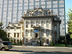
| Bidwell Mansion State Historic Park Bidwell Mansion State Historic Park Bidwell Mansion, located at 525 Esplanade in Chico, California, was the home of General John Bidwell and Annie Bidwell from the late 1868 until 1900, when Gen. Bidwell died. Annie continued to live there until her death in 1918... |
State historic park | Butte Butte County, California Butte County is a county located in the Central Valley of the US state of California, north of the state capital of Sacramento. As of the 2010 census, it had a population of 220,000. The county seat is Oroville. Butte County is the "Land of Natural Wealth and Beauty."Butte County is watered by the... |
1964 | Slated to close July 2012 | Offers tours of the 1868 Victorian Victorian architecture The term Victorian architecture refers collectively to several architectural styles employed predominantly during the middle and late 19th century. The period that it indicates may slightly overlap the actual reign, 20 June 1837 – 22 January 1901, of Queen Victoria. This represents the British and... mansion of influential settlers John John Bidwell John Bidwell was known throughout California and across the nation as an important pioneer, farmer, soldier, statesman, politician, prohibitionist and philanthropist... and Annie Bidwell Annie Bidwell Annie Kennedy Bidwell , with her husband John Bidwell, was a pioneer and founder of society in the Sacramento Valley area of California in the 19th century. She is also known for her contributions to social causes, such as women's suffrage, the temperance movement, and education. Annie Bidwell... . The mansion is on the NRHP National Register of Historic Places The National Register of Historic Places is the United States government's official list of districts, sites, buildings, structures, and objects deemed worthy of preservation... . |
|
| Bidwell-Sacramento River State Park Bidwell-Sacramento River State Park Bidwell-Sacramento River State Park is a state park of California, USA, preserving riparian habitat on the Sacramento River and its tributary Big Chico Creek. The park is located on the border of Butte County and Glenn County. Popular activities include fishing for salmon, steelhead and shad; and... |
State park | Butte Butte County, California Butte County is a county located in the Central Valley of the US state of California, north of the state capital of Sacramento. As of the 2010 census, it had a population of 220,000. The county seat is Oroville. Butte County is the "Land of Natural Wealth and Beauty."Butte County is watered by the... and Glenn Glenn County, California Glenn County is in the California Central Valley. As of 2010, it had a population of 28,122. The county seat is the city of Willows.-History:Glenn County was formed in 1891 from parts of Colusa County. It was named for Dr. Hugh J... |
349 | 1979 | Preserves riparian Riparian zone A riparian zone or riparian area is the interface between land and a river or stream. Riparian is also the proper nomenclature for one of the fifteen terrestrial biomes of the earth. Plant habitats and communities along the river margins and banks are called riparian vegetation, characterized by... habitat on the Sacramento River Sacramento River The Sacramento River is an important watercourse of Northern and Central California in the United States. The largest river in California, it rises on the eastern slopes of the Klamath Mountains, and after a journey south of over , empties into Suisun Bay, an arm of the San Francisco Bay, and... and its tributary Big Chico Creek Big Chico Creek Big Chico Creek originates on Colby Mountain, located in Tehama County, California. The creek flows to its confluence with the Sacramento River in Butte County... . |
|
| Big Basin Redwoods State Park Big Basin Redwoods State Park Big Basin Redwoods State Park is a state park in the U.S. state of California, located in Santa Cruz County, about northwest of Santa Cruz. The park contains almost all of the Waddell Creek watershed, which was formed by the seismic uplift of its rim, and the erosion of its center by the many... |
State park | Santa Cruz Santa Cruz County, California Santa Cruz County is a county located on the Pacific coast of the U.S. state of California, on the California Central Coast. The county forms the northern coast of the Monterey Bay. . As of the 2010 U.S. Census, its population was 262,382. The county seat is Santa Cruz... |
18,050 | 1906 | Established as California's first state park, to preserve coast redwoods on Waddell Creek Waddell Creek Waddell Creek is the name given to both the creek and the watershed that run through Big Basin Redwoods State Park in Santa Cruz County, California... . |
|
| Bodie State Historic Park Bodie, California Bodie is a ghost town in the Bodie Hills east of the Sierra Nevada mountain range in Mono County, California, United States, about 75 miles southeast of Lake Tahoe. It is located east-southeast of Bridgeport, at an elevation of 8379 feet . As Bodie Historic District, the U.S. Department of the... |
State historic park | Mono Mono County, California Mono County is a county located in the east central portion of the U.S. state of California, to the east of the Sierra Nevada between Yosemite National Park and Nevada. As of the 2010 census, the population was 14,202, up from 12,853 at the 2000 census... |
1,016 | 1962 | Preserves the ghost town Ghost town A ghost town is an abandoned town or city. A town often becomes a ghost town because the economic activity that supported it has failed, or due to natural or human-caused disasters such as floods, government actions, uncontrolled lawlessness, war, or nuclear disasters... of Bodie, whose gold-mining heyday ran from 1877–1881, and is now a National Historic Landmark National Historic Landmark A National Historic Landmark is a building, site, structure, object, or district, that is officially recognized by the United States government for its historical significance... . |
|
| Bolsa Chica State Beach Bolsa Chica State Beach Bolsa Chica State Beach is a beach in the state park system of California, USA. It is located in the Huntington Beach community of Sunset Beach in Orange County.... |
State beach | Orange Orange County, California Orange County is a county in the U.S. state of California. Its county seat is Santa Ana. As of the 2010 census, its population was 3,010,232, up from 2,846,293 at the 2000 census, making it the third most populous county in California, behind Los Angeles County and San Diego County... |
169 | 1960 | Offers surf fishing Surf fishing Surf fishing is the sport of catching fish standing on the shoreline or wading in the surf. A general term, surf fishing may or may not include casting a lure or bait, and refers to all types of shore fishing - from sandy and rocky beaches, rock jetties, or even fishing piers... and catching grunion Grunion Grunion are two fish species of the genus Leuresthes: the California grunion, L. tenuis, and the Gulf grunion L. sardinas... by hand. |
|
| Border Field State Park Border Field State Park Border Field State Park is a state park of California, USA, containing beach and coastal habitat on the Mexico – United States border. The park is located within the city limits of Imperial Beach in San Diego County, adjacent to the suburb of Playas de Tijuana in Mexico... |
State park | San Diego San Diego County, California San Diego County is a large county located in the southwestern corner of the US state of California. Hence, San Diego County is also located in the southwestern corner of the 48 contiguous United States. Its county seat and largest city is San Diego. Its population was about 2,813,835 in the 2000... |
1,316 | 1972 | Occupies the southwesternmost point of the contiguous U.S., on the Mexico – United States border. Part of the Tijuana River National Estuarine Research Reserve Tijuana River National Estuarine Research Reserve Tijuana River National Estuarine Research Reserve is a natural reserve encompassing the Tijuana River Estuary, located on the Mexico – United States border, in Imperial Beach, California.-Access and features:... . |
|
| Bothe-Napa Valley State Park Bothe-Napa Valley State Park Bothe-Napa Valley State Park is a state park of California, USA, preserving forested land in Napa Valley. It contains the farthest inland coast redwoods in a California state park... |
State park | Napa Napa County, California Napa County is a county located north of the San Francisco Bay Area in the U.S. state of California. It is coterminous with the Napa, California, Metropolitan Statistical Area. As of 2010 the population is 136,484. The county seat is Napa.... and Sonoma Sonoma County, California Sonoma County, located on the northern coast of the U.S. state of California, is the largest and northernmost of the nine San Francisco Bay Area counties. Its population at the 2010 census was 483,878. Its largest city and county seat is Santa Rosa.... |
1,991 | 1960 | Slated to close July 2012 | Contains the farthest inland coast redwoods in a California state park. |
| Brannan Island State Recreation Area Brannan Island State Recreation Area Brannan Island State Recreation Area is a state park unit of California, USA preserving a maze of waterways in the delta of the Sacramento-San Joaquin River. The recreation area is located in Sacramento County between Rio Vista and Isleton... |
State recreation area | Sacramento Sacramento County, California Sacramento County is a county in the U.S. state of California. Its county seat is Sacramento, which is also the state capital. As of 2010 the county had a population of 1,418,788.... |
329 | 1952 | Slated to close July 2012 | Offers water recreation amid a maze of channels in the Sacramento – San Joaquin River Delta. |
| Burleigh H. Murray Ranch Burleigh H. Murray Ranch Burleigh H. Murray Ranch is a property in the state park system of California, USA, encompassing a hidden valley established as a ranch in 1857. It is located in San Mateo County between Skyline Boulevard and the city of Half Moon Bay, south of California State Route 92... |
Park property | San Mateo San Mateo County, California San Mateo County is a county located in the San Francisco Bay Area of the U.S. state of California. It covers most of the San Francisco Peninsula just south of San Francisco, and north of Santa Clara County. San Francisco International Airport is located at the northern end of the county, and... |
1,325 | 1979 | Encompasses a hidden valley with a historic ranch established in 1857. | |
| Burton Creek State Park Burton Creek State Park Burton Creek State Park is a state park of California, USA, located in Placer County near Truckee.Situated on the outskirts of Tahoe City, the park offers of unpaved roadway for hiking and cross-country skiing. The park was established in 1976.... |
State park | Placer Placer County, California Placer County is a county located in both the Sacramento Valley and Sierra Nevada regions of the U.S. state of California, in what is known as the Gold Country. It stretches from the suburbs of Sacramento to Lake Tahoe and the Nevada border. Because of the expansion of the Greater Sacramento,... |
1,890 | 1976 | Offers 6 miles (9.7 km) of unpaved roadway for hiking and cross-country skiing. | |
| Butano State Park Butano State Park Butano State Park is a state park of California, USA, showcasing a secluded redwood-filled canyon. Located in San Mateo County near Pescadero, the park was established in 1956..... |
State park | San Mateo San Mateo County, California San Mateo County is a county located in the San Francisco Bay Area of the U.S. state of California. It covers most of the San Francisco Peninsula just south of San Francisco, and north of Santa Clara County. San Francisco International Airport is located at the northern end of the county, and... |
4,728 | 1956 | Showcases a secluded redwood-filled valley. | |
| Butte City Project | Park property | Butte Butte County, California Butte County is a county located in the Central Valley of the US state of California, north of the state capital of Sacramento. As of the 2010 census, it had a population of 220,000. The county seat is Oroville. Butte County is the "Land of Natural Wealth and Beauty."Butte County is watered by the... |
37 | 2007 | In development, not open to public | |
| Calaveras Big Trees State Park Calaveras Big Trees State Park Calaveras Big Trees State Park is a state park of California, USA, preserving two groves of giant sequoia trees. It is located northeast of Arnold, California in the middle elevations of the Sierra Nevada... |
State park | Calaveras Calaveras County, California Calaveras County is a county located in the Gold Country of the U.S. state of California. Calaveras is the Spanish word for skulls; the county was reportedly named for the remains of Native Americans discovered by the Spanish explorer Captain Gabriel Moraga. As of the 2010 census, the county had a... and Tuolumne Tuolumne County, California Tuolumne County is a county in the Sierra Nevada of the U.S. state of California. The northern half of Yosemite National Park is located in the eastern part of the county. As of the 2010 census, the population was 55,365, up from 54,501 at the 2000 census... |
6,498 | 1931 | Protects two large groves of giant sequoias Sequoiadendron Sequoiadendron giganteum is the sole living species in the genus Sequoiadendron, and one of three species of coniferous trees known as redwoods, classified in the family Cupressaceae in the subfamily Sequoioideae, together with Sequoia sempervirens and... . |
|
| California Citrus State Historic Park California Citrus State Historic Park California Citrus State Historic Park is an open air museum in the state park system of California, USA, interpreting the historic cultural landscape of the citrus industry. The story of the citrus industry's role in the history and development of California is told in the visitor center... |
State historic park | Riverside Riverside County, California Riverside County is a county in the U.S. state of California. One of 58 California counties, it covers in the southern part of the state, and stretches from Orange County to the Colorado River, which forms the state border with Arizona. The county derives its name from the city of Riverside,... |
248 | 1984 | Interprets the influence of the state's citrus industry Citrus production Citrus fruits are the highest value fruit crop in terms of international trade. There are two main markets for citrus fruit:* the fresh fruit market* the processed citrus fruits market... . |
|
| California State Capitol Museum California State Capitol Museum The California State Capitol Museum comprises a museum in and grounds around the California State Capitol in Sacramento, California, USA. The building has been the home of the California State Legislature since 1869... |
Park property | Sacramento Sacramento County, California Sacramento County is a county in the U.S. state of California. Its county seat is Sacramento, which is also the state capital. As of 2010 the county had a population of 1,418,788.... |
40 | 1982 | Offers exhibits and tours of the California State Capitol California State Capitol The California State Capitol is home to the government of California. The building houses the bicameral state legislature and the office of the governor.... and its grounds. |
|
| California State Indian Museum California State Indian Museum The California State Indian Museum is a museum in the state park system of California, USA, interpreting the diverse cultures of the indigenous peoples of California. It is located in downtown Sacramento. The museum exhibits traditional items illustrating the varying cultures of the state's first... |
State historic park | Sacramento Sacramento County, California Sacramento County is a county in the U.S. state of California. Its county seat is Sacramento, which is also the state capital. As of 2010 the county had a population of 1,418,788.... |
1914 | Interprets the diverse cultures of the indigenous peoples of California Indigenous peoples of California The Indigenous peoples of California are the indigenous inhabitants who have lived or currently live in the geographic area within the current boundaries of California before and after the arrival of Europeans. With over one hundred federally recognized tribes, California has the largest Native... . |
||
| California State Mining and Mineral Museum | Park property | Mariposa Mariposa County, California Mariposa County is a county in the U.S. state of California, located in the western foothills of the Sierra Nevada mountains. It lies north of Fresno, east of Merced, and southeast of Stockton. As of the 2010 census, the population was 18,251 up from 17,130 at the 2000 census... |
1999 | Slated to close July 2012 | Exhibits the official state mineral collection and displays on the region's influential mining heritage. | |
| California State Railroad Museum California State Railroad Museum The California State Railroad Museum is a museum in the state park system of California, USA, interpreting the role of the "iron horse" in connecting California to the rest of the nation. It is located in Old Sacramento at 111 I Street.... |
Point of interest | Sacramento Sacramento County, California Sacramento County is a county in the U.S. state of California. Its county seat is Sacramento, which is also the state capital. As of 2010 the county had a population of 1,418,788.... |
Celebrates the history of rail transportation in California with museum displays, 21 restored locomotive Locomotive A locomotive is a railway vehicle that provides the motive power for a train. The word originates from the Latin loco – "from a place", ablative of locus, "place" + Medieval Latin motivus, "causing motion", and is a shortened form of the term locomotive engine, first used in the early 19th... s, and a heritage railway Heritage railway thumb|right|the Historical [[Khyber train safari|Khyber Railway]] goes through the [[Khyber Pass]], [[Pakistan]]A heritage railway , preserved railway , tourist railway , or tourist railroad is a railway that is run as a tourist attraction, in some cases by volunteers, and... along the Sacramento River Sacramento River The Sacramento River is an important watercourse of Northern and Central California in the United States. The largest river in California, it rises on the eastern slopes of the Klamath Mountains, and after a journey south of over , empties into Suisun Bay, an arm of the San Francisco Bay, and... . |
|||
| Candlestick Point State Recreation Area Candlestick Point State Recreation Area Candlestick Point State Recreation Area is a state park unit of California, USA, providing an urban protected area on San Francisco Bay. The park is located at the southeastern tip of San Francisco immediately south of Hunters Point and north of Sierra Point in Brisbane... |
State recreation area | San Francisco | 204 | 1972 | Slated to close July 2012 | Constitutes California's first urban state recreation area, on the west shore of San Francisco Bay San Francisco Bay San Francisco Bay is a shallow, productive estuary through which water draining from approximately forty percent of California, flowing in the Sacramento and San Joaquin rivers from the Sierra Nevada mountains, enters the Pacific Ocean... . |
| Cardiff State Beach Cardiff State Beach Cardiff State Beach is a protected beach in the state park system of California, USA, located near San Diego. Popular activities include swimming, surfing, and beachcombing.... |
State beach | San Diego San Diego County, California San Diego County is a large county located in the southwestern corner of the US state of California. Hence, San Diego County is also located in the southwestern corner of the 48 contiguous United States. Its county seat and largest city is San Diego. Its population was about 2,813,835 in the 2000... |
507 | 1949 | Provides a sandy, warm-water beach outside San Diego San Diego, California San Diego is the eighth-largest city in the United States and second-largest city in California. The city is located on the coast of the Pacific Ocean in Southern California, immediately adjacent to the Mexican border. The birthplace of California, San Diego is known for its mild year-round... . |
|
| Carlsbad State Beach Carlsbad State Beach Carlsbad State Beach is a protected beach in the state park system of California, USA, located in Carlsbad. It is a San Diego County beach with coastal bluffs. Popular activities include swimming, surfing, scuba diving, fishing, and beachcombing. Many visitors camp on the campsites on top of the... |
State beach | San Diego San Diego County, California San Diego County is a large county located in the southwestern corner of the US state of California. Hence, San Diego County is also located in the southwestern corner of the 48 contiguous United States. Its county seat and largest city is San Diego. Its population was about 2,813,835 in the 2000... |
44 | 1933 | Features a small beach at the foot of coastal bluffs. | |
| Carmel River State Beach Carmel River State Beach Carmel River State Beach is a state park unit of California, USA, featuring a protected beach with a lagoon formed by the Carmel River. The lagoon attracts a large number of migratory birds. The state beach includes Monastery Beach, which is popular with scuba divers... |
State beach | Monterey Monterey County, California Monterey County is a county located on the Pacific coast of the U.S. state of California, its northwestern section forming the southern half of Monterey Bay. The northern half of the bay is in Santa Cruz County. As of 2010, the population was 415,057. The county seat and largest city is Salinas... |
297 | 1953 | Protects a 1 miles (1.6 km) beach and a lagoon Lagoon A lagoon is a body of shallow sea water or brackish water separated from the sea by some form of barrier. The EU's habitat directive defines lagoons as "expanses of shallow coastal salt water, of varying salinity or water volume, wholly or partially separated from the sea by sand banks or shingle,... at the mouth of the Carmel River Carmel River The Carmel River is a river on the Central Coast of California in Monterey County that originates in the Santa Lucia Mountains. The river flows northwest through the Carmel Valley with its mouth at the Pacific Ocean south of Carmel-by-the-Sea. It is often considered the northern boundary of Big Sur... which attracts many migratory birds. |
|
| Carnegie State Vehicular Recreation Area Carnegie State Vehicular Recreation Area Carnegie State Vehicular Recreation Area is a state park unit of California, USA, providing off-roading opportunities in the Diablo Range. Located in southern Alameda and San Joaquin counties, it is one of six state vehicular recreation areas administered by the California Department of Parks and... |
State vehicular recreation area | Alameda Alameda County, California Alameda County is a county in the U.S. state of California. It occupies most of the East Bay region of the San Francisco Bay Area. As of the 2010 census it had a population of 1,510,271, making it the 7th most populous county in the state... & San Joaquin San Joaquin County, California San Joaquin County is a county located in Central Valley of the U.S. state of California, just east of the San Francisco Bay Area. As of the 2010 census, the population was 685,306. The county seat is Stockton.-History:... |
5,075 | 1979 | Provides off-roading Off-roading Off-roading is a term for driving a vehicle on unsurfaced roads or tracks, made of materials such as sand, gravel, riverbeds, mud, snow, rocks, and other natural terrain.-Off-road vehicle:... opportunities in the Diablo Range Diablo Range The Diablo Range is a mountain range in the California Coast Ranges subdivision of the Pacific Coast Ranges. It is located in the eastern San Francisco Bay area south to the Salinas Valley area of northern California, the United States.-Geography:... around the former townsite of Carnegie Carnegie, California Carnegie is a former town in Corral Hollow, in San Joaquin County, California.It waa discovered that the Tesla coal mines in Corral Hollow contained a rich deposit of clay. Fueled by California's rapid population growth and the subsequent demand for building materials, the mine owners, San... . |
|
| Carpinteria State Beach Carpinteria State Beach Carpinteria State Beach is a protected beach in the state park system of California, USA. It is located south of Santa Barbara in the city of Carpinteria. The park has of beachfront. Recreational activities include swimming, surf fishing, camping, and tidepool exploration. The park was... |
State beach | Santa Barbara Santa Barbara County, California Santa Barbara County is a county located in the southern portion of the U.S. state of California, on the Pacific coast. As of 2010 the county had a population of 423,895. The county seat is Santa Barbara and the largest city is Santa Maria.-History:... and Ventura Ventura County, California Ventura County is a county in the southern part of the U.S. state of California. It is located on California's Pacific coast. It is often referred to as the Gold Coast, and has a reputation of being one of the safest populated places and one of the most affluent places in the country... |
62 | 1932 | Offers a mile-long beach in the city of Carpinteria Carpinteria, California Carpinteria is a small oceanside city located in southeastern Santa Barbara County, California, east of Santa Barbara and northwest of Ventura. The population was 13,040 at the 2010 census, down from 14,194 at the 2000 census.... . |
|
| Caspar Headlands State Beach Caspar Headlands State Beach Caspar Headlands State Beach is a protected beach in the state park system of California, USA. It is located in Northern California in Mendocino County near the village of Caspar. The park was established in 1972.-History:... |
State beach | Mendocino Mendocino County, California Mendocino County is a county located on the north coast of the U.S. state of California, north of the greater San Francisco Bay Area and west of the Central Valley. As of the 2010 census, the population was 87,841, up from 86,265 at the 2000 census... |
75 | 1972 | ||
| Caspar Headlands State Natural Reserve | State natural reserve | Mendocino Mendocino County, California Mendocino County is a county located on the north coast of the U.S. state of California, north of the greater San Francisco Bay Area and west of the Central Valley. As of the 2010 census, the population was 87,841, up from 86,265 at the 2000 census... |
1972 | Preserves a small strip of rugged coastline. | ||
| Castaic Lake State Recreation Area Castaic Lake State Recreation Area Castaic Lake State Recreation Area is a state park unit of California, USA, on the shores of Castaic Lake. It is located in northwestern Los Angeles County near the community of Castaic, north of Santa Clarita. It lies adjacent to the Angeles National Forest. The park was established in 1965.-... |
State recreation area | Los Angeles Los Angeles County, California Los Angeles County is a county in the U.S. state of California. As of 2010 U.S. Census, the county had a population of 9,818,605, making it the most populous county in the United States. Los Angeles County alone is more populous than 42 individual U.S. states... |
4,224 | 1965 | Features 29 miles (46.7 km) of shoreline on Castaic Lake Castaic Lake Castaic Lake is an artificial lake on Castaic Creek formed by Castaic Dam, in northwestern Los Angeles County, California, near the town of Castaic. The lake with a surface elevation of approximately above sea level is the terminus of the West Branch of the California Aqueduct, though some comes... . |
|
| Castle Crags State Park Castle Crags Castle Crags is a dramatic and well-known rock formation in Northern California. Although the mountains of Northern California consist largely of rocks of volcanic and sedimentary origin, granite bodies intruded many parts of the area during the Jurassic period... |
State park | Shasta Shasta County, California Shasta County is a county located in the northern portion of the U.S. state of California. The county occupies the northern reaches of the Sacramento Valley, with portions extending into the southern reaches of the Cascade Range. As of the 2010 census, the population was 177,223, up from 163,256... |
3,905 | 1934 | Slated to close July 2012 | Provides access to the Castle Crags Wilderness Castle Crags Wilderness The Castle Crags Wilderness is a wilderness area located 40 miles north of Redding, California within the Shasta-Trinity National Forest. The US Congress passsd the California Wilderness Act in 1984 which set aside the wilderness... , with its 6000 feet (1,828.8 m) rock crags. |
| Castle Rock State Park Castle Rock State Park (California) Castle Rock State Park is a state park of California, USA, located along the crest of the Santa Cruz Mountains. It embraces coast redwood, Douglas fir, and madrone forest, most of which has been left in its wild, natural state. Steep canyons are sprinkled with unusual rock formations that is a... |
State park | Santa Clara Santa Clara County, California Santa Clara County is a county located at the southern end of the San Francisco Bay Area in the U.S. state of California. As of 2010 it had a population of 1,781,642. The county seat is San Jose. The highly urbanized Santa Clara Valley within Santa Clara County is also known as Silicon Valley... , Santa Cruz Santa Cruz County, California Santa Cruz County is a county located on the Pacific coast of the U.S. state of California, on the California Central Coast. The county forms the northern coast of the Monterey Bay. . As of the 2010 U.S. Census, its population was 262,382. The county seat is Santa Cruz... , and San Mateo San Mateo County, California San Mateo County is a county located in the San Francisco Bay Area of the U.S. state of California. It covers most of the San Francisco Peninsula just south of San Francisco, and north of Santa Clara County. San Francisco International Airport is located at the northern end of the county, and... |
5,242 | 1968 | Slated to close July 2012 | Encompasses a wild forest with rock climbing Rock climbing Rock climbing also lightly called 'The Gravity Game', is a sport in which participants climb up, down or across natural rock formations or artificial rock walls. The goal is to reach the summit of a formation or the endpoint of a pre-defined route without falling... opportunities along the crest of the Santa Cruz Mountains Santa Cruz Mountains The Santa Cruz Mountains, part of the Pacific Coast Ranges, are a mountain range in central California, United States. They form a ridge along the San Francisco Peninsula, south of San Francisco, separating the Pacific Ocean from San Francisco Bay and the Santa Clara Valley, and continuing south,... . |
| Castro Adobe Castro Adobe The Rancho San Andrés Castro Adobe was the governing seat of the Castro family. It also served as a fiesta house.-History:The house was built in 1848–1849 by Juan José Castro. His father Jose Joaquin Castro , came to California as a 6 year old with his family from Sinaloa Mexico on the 1775–1776... |
Park property | Santa Cruz Santa Cruz County, California Santa Cruz County is a county located on the Pacific coast of the U.S. state of California, on the California Central Coast. The county forms the northern coast of the Monterey Bay. . As of the 2010 U.S. Census, its population was 262,382. The county seat is Santa Cruz... |
1 | 2002 | In development, not open to public | Comprises the grand 1849 hacienda of the prominent Castro family on their Rancho San Andrés Rancho San Andrés Rancho San Andrés was a Mexican land grant in present day Santa Cruz County, California given in 1833 by Governor José Figueroa to José Joaquín Castro. The grant on Monterey Bay extended from La Selva Beach on the north to Watsonville Slough on the south... . The hacienda is on the NRHP National Register of Historic Places The National Register of Historic Places is the United States government's official list of districts, sites, buildings, structures, and objects deemed worthy of preservation... . |
| Caswell Memorial State Park Caswell Memorial State Park Caswell Memorial State Park is a state park of California, USA, preserving a riparian forest along the Stanislaus River. It is located in southern San Joaquin County southwest of the town of Ripon. Riparian Oak Woodland, located in this park, is threatened and the park is trying to protect it. It... |
State park | San Joaquin San Joaquin County, California San Joaquin County is a county located in Central Valley of the U.S. state of California, just east of the San Francisco Bay Area. As of the 2010 census, the population was 685,306. The county seat is Stockton.-History:... |
258 | 1952 | Preserves a riparian forest Riparian forest A riparian forest is a forested area of land adjacent to a body of water such as a river, stream, pond, lake, marshland, estuary, canal, sink or reservoir. -Etymology:... along the Stanislaus River Stanislaus River The Stanislaus River in California is one of the largest tributaries of the San Joaquin River. The river is long and has north, middle and south forks... . |
|
| Cayucos State Beach Cayucos State Beach Cayucos State Beach is a protected beach in the state park system of California, USA. It is located in Cayucos, San Luis Obispo County. The sandy beach environment supports uses of swimming and surfing... |
State beach | San Luis Obispo San Luis Obispo County, California San Luis Obispo County is a county located along the Pacific Ocean in the Central Coast of the U.S. state of California, between Los Angeles and the San Francisco Bay Area. As of the 2010 census its population was 269,637, up from 246,681 at the 2000 census... |
16 | 1940 | Provides a swimming and surfing beach in the beach town of Cayucos Cayucos, California Cayucos is a census-designated place located on the coast in San Luis Obispo County, California along California State Route 1 between Cambria to the north and Morro Bay to the south... . |
|
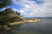
| China Camp State Park China Camp State Park China Camp State Park is a state park of California, USA, surrounding a historic Chinese American shrimp-fishing village and a salt marsh. The park is located in San Rafael, California, on the shore of San Pablo Bay. It is known for its hiking and mountain biking trails, scenic views, and open... |
State park | Marin Marin County, California Marin County is a county located in the North San Francisco Bay Area of the U.S. state of California, across the Golden Gate Bridge from San Francisco. As of 2010, the population was 252,409. The county seat is San Rafael and the largest employer is the county government. Marin County is well... |
1,514 | 1976 | Slated to close July 2012 | Surrounds an 1880s Chinese American Chinese American Chinese Americans represent Americans of Chinese descent. Chinese Americans constitute one group of overseas Chinese and also a subgroup of East Asian Americans, which is further a subgroup of Asian Americans... shrimp-fishing Shrimp fishery A shrimp fishery is a fishery directed toward harvesting either shrimp or prawns. .-Commercial shrimping:... village and salt marsh Salt marsh A salt marsh is an environment in the upper coastal intertidal zone between land and salt water or brackish water, it is dominated by dense stands of halophytic plants such as herbs, grasses, or low shrubs. These plants are terrestrial in origin and are essential to the stability of the salt marsh... es on San Pablo Bay San Pablo Bay San Pablo Bay is a tidal estuary that forms the northern extension of San Francisco Bay in northern California in the United States. Most of the Bay is shallow; however, there is a deep water channel approximately in mid bay, which allows access to Sacramento, Stockton, Benicia, Martinez, and... . |
| Chino Hills State Park Chino Hills State Park Chino Hills State Park is a state park of California, USA, in the Chino Hills, foothills of the Santa Ana Mountains. It is a critical link in the Chino–Puente Hills wildlife corridor, and a major botanical habitat reserve for resident and migrating wildlife.... |
State park | Orange Orange County, California Orange County is a county in the U.S. state of California. Its county seat is Santa Ana. As of the 2010 census, its population was 3,010,232, up from 2,846,293 at the 2000 census, making it the third most populous county in California, behind Los Angeles County and San Diego County... , Riverside Riverside County, California Riverside County is a county in the U.S. state of California. One of 58 California counties, it covers in the southern part of the state, and stretches from Orange County to the Colorado River, which forms the state border with Arizona. The county derives its name from the city of Riverside,... , and San Bernardino San Bernardino County, California San Bernardino County is a county in the U.S. state of California. As of the 2010 census, the population was 2,035,210, up from 1,709,434 as of the 2000 census... |
14,173 | 1981 | Preserves a large tract of the Chino Hills Chino Hills The Chino Hills are a mountain range on the border of Orange, Los Angeles, and San Bernardino Counties, California, with a small portion in Riverside County... . |
|
| Chumash Painted Cave State Historic Park | State historic park | Santa Barbara Santa Barbara County, California Santa Barbara County is a county located in the southern portion of the U.S. state of California, on the Pacific coast. As of 2010 the county had a population of 423,895. The county seat is Santa Barbara and the largest city is Santa Maria.-History:... |
1976 | Preserves a sandstone cave bearing rock art of the Chumash people Rock art of the Chumash people Chumash rock art is a genre of paintings on caves, mountains, cliffs, or other living rock surfaces, created by the Chumash people of southern California. Pictographs and petroglyphs are common through interior California, the rock painting tradition thrived until the 19th century... . |
||
| Clay Pit State Vehicular Recreation Area | State vehicular recreation area | Butte Butte County, California Butte County is a county located in the Central Valley of the US state of California, north of the state capital of Sacramento. As of the 2010 census, it had a population of 220,000. The county seat is Oroville. Butte County is the "Land of Natural Wealth and Beauty."Butte County is watered by the... |
220 | 1981 | Provides off-roading Off-roading Off-roading is a term for driving a vehicle on unsurfaced roads or tracks, made of materials such as sand, gravel, riverbeds, mud, snow, rocks, and other natural terrain.-Off-road vehicle:... opportunities in the shallow clay pit Clay pit A clay pit is a quarry or mine for the extraction of clay, which is generally used for manufacturing pottery, bricks or Portland cement.The brickyard or brickworks is often located alongside the clay pit to reduce the transport costs of the raw material. These days pottery producers are often not... excavated for material to build the Oroville Dam Oroville Dam Oroville Dam spans the Feather River about northeast of the city of Oroville, California. It forms Lake Oroville, which stores water for irrigation, flood control, municipal water supply and hydroelectricity generation in California's Sacramento Valley. The dam lies in the foothills of the Sierra... . |
|
| Clear Lake State Park Clear Lake State Park (California) Clear Lake State Park is a state park of California, USA, on Clear Lake. The park is popular for water recreation. Amenities include 149 developed campsites spread across four campground areas, two group campsites, a swimming beach with showers, a boat launch, and a marina... |
State park | Lake Lake County, California Lake County is a county located in the north central portion of the U.S. state of California, north of the San Francisco Bay Area. It takes its name from Clear Lake, the dominant geographic feature in the county and the largest natural lake wholly within California... |
590 | 1949 | Provides recreation opportunities on the southwest shore of Clear Lake, the largest freshwater lake within California's borders. | |
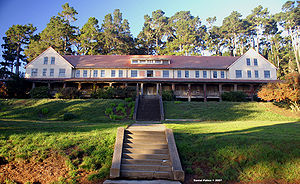
| Colonel Allensworth State Historic Park Colonel Allensworth State Historic Park Colonel Allensworth State Historic Park is a state park unit of California, USA, preserving Allensworth, the only California town to be founded, financed and governed by African Americans. The small farming community was founded in 1908 by Lt. Colonel Allen Allensworth, Professor William Payne,... |
State historic park | Tulare Tulare County, California Tulare County is a county located in the Central Valley of the U.S. state of California, south of Fresno. Sequoia National Park is located in the county, as are part of Kings Canyon National Park, in its northeast corner , and part of Mount Whitney, on its eastern border... |
3,715 | 1973 | Interprets the town of Allensworth Allensworth, California Allensworth is a census-designated place in Tulare County, California. Allensworth sits at an elevation of . The 2010 United States census reported Allensworth's population was 471.... , founded in 1908 as a haven for African American African American African Americans are citizens or residents of the United States who have at least partial ancestry from any of the native populations of Sub-Saharan Africa and are the direct descendants of enslaved Africans within the boundaries of the present United States... s by Colonel Allen Allensworth Allen Allensworth Allen Allensworth was an American soldier and chaplain in the United States Army, a Baptist minister and educator, who had been born into slavery. He escaped by joining the 44th Illinois Volunteers during the American Civil War, and later served two years in the Navy... and other community leaders. The town is a district on the NRHP National Register of Historic Places The National Register of Historic Places is the United States government's official list of districts, sites, buildings, structures, and objects deemed worthy of preservation... . |
|
| Columbia State Historic Park Columbia State Historic Park Columbia State Historic Park, also known as Columbia Historic District, is a California state park and National Historic Landmark District located in Columbia, California. It includes almost 30 buildings built during the California Gold Rush, most of which remain today... |
State historic park | Tuolumne Tuolumne County, California Tuolumne County is a county in the Sierra Nevada of the U.S. state of California. The northern half of Yosemite National Park is located in the eastern part of the county. As of the 2010 census, the population was 55,365, up from 54,501 at the 2000 census... |
273 | 1946 | Interprets a preserved California Gold Rush California Gold Rush The California Gold Rush began on January 24, 1848, when gold was found by James W. Marshall at Sutter's Mill in Coloma, California. The first to hear confirmed information of the gold rush were the people in Oregon, the Sandwich Islands , and Latin America, who were the first to start flocking to... town. The town is a National Historic Landmark National Historic Landmark A National Historic Landmark is a building, site, structure, object, or district, that is officially recognized by the United States government for its historical significance... District. |
|
| Colusa-Sacramento River State Recreation Area | State recreation area | Colusa Colusa County, California Colusa County is a county located in the Central Valley of the U.S. state of California, northwest of state capital Sacramento. As of the 2010 census, its population was 21,419. The county seat is Colusa.-History:... |
301 | 1955 | Slated to close July 2012 | Adjoins a stretch of the Sacramento River Sacramento River The Sacramento River is an important watercourse of Northern and Central California in the United States. The largest river in California, it rises on the eastern slopes of the Klamath Mountains, and after a journey south of over , empties into Suisun Bay, an arm of the San Francisco Bay, and... known for its fishing. |
| Corona del Mar State Beach Corona del Mar State Beach Corona del Mar State Beach is a protected beach in the state park system of California, USA. It is located in Corona del Mar, Newport Beach, and managed by the California Department of Parks and Recreation... |
State beach | Orange Orange County, California Orange County is a county in the U.S. state of California. Its county seat is Santa Ana. As of the 2010 census, its population was 3,010,232, up from 2,846,293 at the 2000 census, making it the third most populous county in California, behind Los Angeles County and San Diego County... |
30 | 1947 | Provides a half-mile-long swimming beach adjacent to the Newport Beach Newport Beach, California Newport Beach, incorporated in 1906, is a city in Orange County, California, south of downtown Santa Ana. The population was 85,186 at the 2010 census.The city's median family income and property values consistently place high in national rankings... harbor jetty. |
|
| Cowell Ranch/John Marsh State Historic Park | State historic park | Contra Costa Contra Costa County, California Contra Costa County is a primarily suburban county in the San Francisco Bay Area of the U.S. state of California. As of the 2010 census, it had a population of 1,049,025... |
3,676 | 1981 | In development, not open to public | Includes Rancho Los Meganos Rancho Los Meganos Rancho Los Meganos was a Mexican land grant in present day Contra Costa County, California given in 1835 by Governor José Castro to Jose Noriega. "Meganos" means "sand dunes" in Spanish. Rancho Los Meganos extends eastward from present day Antioch along the San Joaquin River to the Old River... and the 1856 ranchhouse of John Marsh John Marsh (pioneer) “Doctor” John Marsh was born in 1799 in South Danvers, Massachusetts and died in Pacheco, California in 1856. He was an early pioneer and settler in California, and although he did not have a medical degree, is often regarded as the first person to practice medicine in California.-Early life:Marsh... . |
| Crystal Cove State Park Crystal Cove State Park Crystal Cove State Park is a state park of California, USA, encompassing of Pacific coastline, inland chaparral canyons, and the Crystal Cove Historic District of beach houses. The park located in Newport Beach. Crystal Cove is a stretch of coastal cliffs and a beachfront cove situated between... |
State park | Orange Orange County, California Orange County is a county in the U.S. state of California. Its county seat is Santa Ana. As of the 2010 census, its population was 3,010,232, up from 2,846,293 at the 2000 census, making it the third most populous county in California, behind Los Angeles County and San Diego County... |
3,936 | 1979 | Encompasses cliffbound coastline, insland chaparral canyons, and the NRHP National Register of Historic Places The National Register of Historic Places is the United States government's official list of districts, sites, buildings, structures, and objects deemed worthy of preservation... -listed Crystal Cove Historic District Crystal Cove Historic District The Crystal Cove Historic District is a part of the Crystal Cove State Park located in Newport Beach, California. It is listed on the National Register of Historic Places encompassing along the Southern California coast. It was listed on the National Register not only because of its significance... of 1920s and 30s beach cottages. |
|
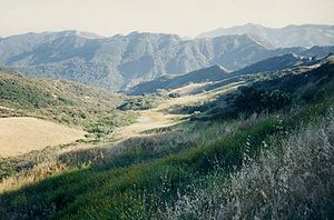
| Cuyamaca Rancho State Park Cuyamaca Rancho State Park Cuyamaca Rancho State Park is a state park located forty miles east of San Diego, California in the Laguna Mountains of the Peninsular Ranges. The park's 26,000 acres feature pine, fir, and oak forests, with meadows and streams that exist due to the relatively high elevation of the area compared... |
State park | San Diego San Diego County, California San Diego County is a large county located in the southwestern corner of the US state of California. Hence, San Diego County is also located in the southwestern corner of the 48 contiguous United States. Its county seat and largest city is San Diego. Its population was about 2,813,835 in the 2000... |
24,693 | 1933 | Preserves an expansive tract of forests and meadows above 5000 feet (1,524 m) in the Laguna Mountains Laguna Mountains The Laguna Mountains are a section of the Peninsular Ranges in eastern San Diego County, California. The mountains run in a northwest/southeast alignment for approximately .... , on the former Rancho Cuyamaca Rancho Cuyamaca Rancho Cuyamaca was a Mexican land grant in present day San Diego County, California given in 1845 by Governor Pío Pico to Agustin Olvera. The grant extended south of present day Julian and encompassed Cuyamaca Rancho State Park, Lake Cuyamaca, and Cuyamaca Peak.-History:Olvera remained in Los... . |
|
D
- D. L. Bliss State ParkD. L. Bliss State ParkD. L. Bliss State Park is a California state park located on the west shore of Lake Tahoe approximately 25 miles north of the city of South Lake Tahoe. In 1929, the Duane Leroy Bliss family donated to the state for the park. Rubicon Point Light, the highest lighthouse in the United States, is...
- Del Norte Coast Redwoods State ParkDel Norte Coast Redwoods State ParkDel Norte Coast Redwoods State Park is a state park located in California. The park, established in 1927, is with approximately 50% old-growth coast redwood and of wild coastline. The park is a World Heritage Site & Biosphere Preserve....
- Delta Meadows
- Dockweiler State BeachDockweiler State BeachDockweiler State Beach is a Los Angeles beach protected under the state park system. Part of the park is located directly under the flight path of the immediately adjacent Los Angeles International Airport. Additionally, it is one of the few beaches in Los Angeles County where bonfires are permitted...
- Doheny State BeachDoheny State BeachDoheny State Beach, protected as part of the California Department of Parks and Recreation, is a beach on the Pacific coast of Orange County, in Dana Point, Southern California....
- Donner Memorial State ParkDonner Memorial State ParkDonner Memorial State Park is a US state park located near Truckee, California. The park is named after the ill-fated Donner Party, and contains the Emigrant Trail Museum and the Pioneer Monument dedicated to them. The Donner Camp site at Alder Creek, where the Donner families were trapped by...
E
- Eastshore State ParkEastshore State ParkEastshore State Park is a state park and wildlife refuge along the San Francisco Bay shoreline of the East Bay between the cities of Richmond, Albany, Berkeley, Emeryville, and Oakland. It encompasses remnant natural wetlands, restored wetlands as well as landfill west of the Eastshore Freeway. It...
- El Capitán State BeachEl Capitán State BeachEl Capitán State Beach is a protected beach in southern California, United States, located about 20 miles west of downtown Santa Barbara. El Capitan has a day use beach as well as a campground with 131 sites, 6 of which are RV only, and 5 group sites...
- El Escorpion State Park
- El Presidio de Santa Barbara State Historic ParkPresidio of Santa BarbaraThe El Presidio Real de Santa Bárbara, also known as the Royal Presidio of Santa Barbara, was a military installation in Santa Barbara, California. It was built by Spain in 1782, with the mission of defending the Second Military District in California...
- Emerald Bay State ParkEmerald Bay State ParkEmerald Bay State Park is a state park located around Emerald Bay, a National Natural Landmark since 1968, at Lake Tahoe, California. The park is home to Eagle Falls and Vikingsholm, a 38-room mansion that is one of the finest examples of Scandinavian architecture in the United States. The park...
- Emeryville Crescent State Marine ReserveEmeryville Crescent State Marine ReserveEmeryville Crescent State Marine Reserve is a 103.5 acres protected reserve stretching from the eastern approach of the San Francisco – Oakland Bay Bridge within Oakland, California to the foot of Powell Street in Emeryville, California in the San Francisco Bay Area...
- Emma Wood State BeachEmma Wood State BeachEmma Wood State Beach is a protected beach in California, located west of the city of Ventura. The beach was named after Miss Emma Catherine Wood.-Activities:Although popular for fishing, it is probably most famous for its amazing surf...
- Empire Mine State Historic ParkEmpire Mine State Historic ParkEmpire Mine State Historic Park is a state-protected mine and park in the Sierra Nevada Mountains in Grass Valley, California. The Empire Mine is on the National Register of Historic Places and a federal Historic District. Since 1975, California State Parks has administered and maintained the mine...
- Estero Bluffs State ParkEstero Bluffs State ParkEstero Bluffs State Park is a California State Park located at Estero Bay.-Proposed for closure:Estero Bluffs State Park is one of the 48 California state parks proposed for closure in January 2008 by California's Governor Arnold Schwarzenegger as part of a deficit reduction program.-External...
F
- Folsom Lake State Recreation AreaFolsom Lake State Recreation AreaFolsom Lake State Recreation Area is located on and around Folsom Lake, near the Sierra-Nevada foothills city of Folsom, California about 25 miles east of Sacramento. Latitude/Longitude: 38.7075 / -121.1549...
- Folsom Powerhouse State Historic ParkFolsom Powerhouse State Historic ParkFolsom Powerhouse State Historic Park is a historical site located in Folsom near Sacramento, California, in the United States. Built in the late 19th century by the Natoma Water and Mining Company and prison labor from Folsom Prison, the hydroelelectric powerhouse first delivered power to...
- The Forest of Nisene Marks State Park
- Fort Humboldt State Historic ParkFort Humboldt State Historic ParkFort Humboldt State Historic Park is a California state park located in the southern portion of Eureka, just off U.S. Route 101. The North Coast regional headquarters of the California State Parks is located onsite.-Early years, 1853–1860:...
- Fort Ord Dunes State ParkFort Ord Dunes State ParkFort Ord Dunes State Park is a 979-acre state park on Monterey Bay, in Monterey County, California, in the United States.The state park includes a boardwalk, a path to the beach, a four-mile road for walking and biking, and interpretive exhibits describing its former use as a military training area...
- Fort Ross State Historic ParkFort Ross State Historic ParkFort Ross State Historic Park is a protected historic site in the U.S. state of California. It includes Fort Ross, the former Russian settlement, with the surrounding area comprising the immediate coastline and the native Coast Redwood forests extending inland.-Fort Ross:Fort Ross was founded by...
- Fort Tejon State Historic Park
- Franks Tract State Recreation AreaFranks Tract State Recreation AreaFranks Tract State Recreation Area is a protected area in the U.S. state of California. It is accessible only by water.Franks Tract, which is often called a submerged lake, is situated between the San Joaquin River and Bethel Island...
- Fremont Peak State ParkFremont Peak State ParkFremont Peak State Park is a state park located in the Gabilan Range between Monterey County and San Benito County, California. It provides an opportunity to view the local environment and distant vistas....
G
- Garrapata State ParkGarrapata State ParkGarrapata State Park is a California State Park located on Highway 1, 6.7 miles south of Carmel and 18 miles north of Big Sur on the Monterey coast. It is marked only with one sign on the west side of the road. Numbered turnouts mark each parking area....
- Gaviota State ParkGaviota State ParkGaviota State Park is a California State Park located in southern Santa Barbara County, California, U.S., about 33 miles west of the city of Santa Barbara. It consists of 2,790 acres extending from the Pacific coast to the crest of the Santa Ynez Mountains, and is adjacent to Los Padres National...
- George J. Hatfield State Recreation AreaGeorge J. Hatfield State Recreation AreaThe George J. Hatfield State Recreation Area is in the San Joaquin valley about 20 miles south of Modesto, California and is surrounded by the Merced River. The park has many trees and is home to various wildlife, especially birds. Swimming, fishing and picnicking are popular activities.-Proposed...
- Governor's Mansion State Historic ParkGovernor's Mansion State Historic ParkGovernor's Mansion State Historic Park is the location of Historic Governor's Mansion of California, the former official home of the Governor of California. The mansion is listed on the National Register of Historic Places....
- Gray Whale Cove State BeachGray Whale Cove State BeachGray Whale Cove State Beach is a privately operated beach with special regulations, schedules, and fees, north of Montara, California, USA, by Highway 1. It features a sheltered cove surrounded by abrupt cliffs, with a steep trail....
- Great Valley Grasslands State ParkGreat Valley Grasslands State ParkThe Great Valley Grasslands State Park, in central Northern California-U.S., preserves one of few intact original remnants of the formerly extensive and predominant native grasslands on the floor of the Sacramento and San Joaquin Valleys, in the California State Park system of protected areas...
- Greenwood State BeachGreenwood State BeachGreenwood State Beach, also known as Elk Beach, is located in the unincorporated village of Elk in Mendocino County. It is located about 15 miles north of Point Arena on Highway 1.-History:...
- Grizzly Creek Redwoods State ParkGrizzly Creek Redwoods State ParkGrizzly Creek Redwoods State Park is located 20 Miles east of Eureka, California then another east of Fortuna, California on State Route 36. This low use park containing 30 campsites is sited on the Van Duzen River. The small park was created by a donation from Owen R...
- Grover Hot Springs State ParkGrover Hot Springs State ParkGrover Hot Springs State Park is a state park in eastern California, USA that was sold to the Parks and Recreation Department in the 60's. Accessed from Markleeville...
H
- Half Moon Bay State BeachHalf Moon Bay State BeachHalf Moon Bay State Beach is a stretch of protected beaches in Half Moon Bay, California. It includes:* Francis Beach,* Venice Beach,* Dunes Beach, and* Roosevelt Beach ....
- Harmony Headlands State ParkHarmony Headlands State ParkHarmony Headlands State Park is a California state park in San Luis Obispo County, between the towns of Cayucos and Harmony. It was reopened to the public in November 2008, after a five-year delay.Harmony Headlands State Park is located at ....
- Harry A. Merlo State Recreation Area
- Hatton CanyonHatton CanyonHatton Canyon is a protected area in Monterey County, California. It was under the control of the CalTrans, due to plans dating from 1952 calling for a freeway to be constructed through the canyon, until Governor Gray Davis signed it over to the California State Parks in 2002. It is currently...
- Hearst San Simeon State Historical Monument
- Heber Dunes State Vehicular Recreation Area
- Hendy Woods State ParkHendy Woods State ParkHendy Woods State Park is a state park located in Mendocino County, California. The park contains two groves of old growth Coast Redwood: Big Hendy and Little Hendy . The Navarro River runs through the length of the park....
- Henry Cowell Redwoods State ParkHenry Cowell Redwoods State ParkHenry Cowell Redwoods State Park is a California State Park located in Santa Cruz County, primarily in the area in-between the cities of Santa Cruz, Felton, and Scotts Valley, and the University of California at Santa Cruz, and it includes an extension in the Fall Creek area.-Geography:The main...
- Henry W. Coe State ParkHenry W. Coe State ParkHenry W. Coe State Park is a California state park located in Santa Clara and Stanislaus counties. It contains over 86,000 acres , making it the largest state park in northern California, and the second-largest in the state...
- Hollister Hills State Vehicular Recreation Area
- Humboldt Lagoons State ParkHumboldt Lagoons State ParkHumboldt Lagoons State Park is a state park located in northern California. The state park includes access from U.S. Route 101 to three lagoons on the Pacific coast between Eureka, California and the Oregon border. Big Lagoon is the largest and southernmost lagoon. Stone Lagoon is the middle...
- Humboldt Redwoods State ParkHumboldt Redwoods State ParkHumboldt Redwoods State Park is located south of Eureka, California in southern Humboldt County, within northern California. Established by the Save-the-Redwoods League in 1921 with the dedication of the Raynal Bolling Memorial Grove, it has grown to become the third largest park in the California...
- Hungry Valley State Vehicular Recreation Area
- Huntington State BeachHuntington State BeachHuntington State Beach is a protected beach in Southern California, located in the City of Huntington Beach in Orange County.The California State Park extends two miles from Newport Beach north to Beach Blvd. where the Huntington City Beach begins.This beach is a popular destination for many...
J
- Jack London State Historic ParkJack London State Historic ParkJack London State Historic Park, also known as Jack London Home and Ranch, is a California State Historic Park near Glen Ellen, California, United States, situated on the eastern slope of Sonoma Mountain...
- Jedediah Smith Redwoods State ParkJedediah Smith Redwoods State ParkJedediah Smith Redwoods Park, established in 1929, was named after the noted fur trapper Jedediah Smith, who visited its location during an 1826 expedition. It is located in the northern part of the U.S. state of California, nine miles east of Crescent City, on U.S. Route 199...
- John B. Dewitt State Reserve
- John Little State ReserveJohn Little State ReserveJohn Little State Reserve is a protected area on the Big Sur coast of Monterey County in California.It protects the rigged steep cliffs where Lime Creek meets the Pacific Ocean. It also has a cabin from 1917 where early conservationist Elizabeth K. Livermore lived.- External links :*...
- Jug Handle State Reserve
- Julia Pfeiffer Burns State ParkJulia Pfeiffer Burns State ParkJulia Pfeiffer Burns State Park is a state-protected park in Big Sur, located in Monterey County, California. The park is administered and maintained by California State Parks. It is located south of Carmel and covers over of land. A main feature of the park is McWay Falls, which drops over a...
K
- Kenneth Hahn State Recreation AreaKenneth Hahn State Recreation AreaKenneth Hahn State Recreation Area or "Hahn Park" is a state park and recreation area in the California Department of Parks and Recreation system...
- Kings Beach State Recreation Area
- Kruse Rhododendron State Reserve
L
- La Purísima Mission State Historic ParkLa Purísima Mission State Historic ParkLa Purísima Mission State Historic Park is a California State Park located near Lompoc, California, United States, and it is considered to be the most completely restored mission in California, with ten of the original buildings fully restored and furnished, including the church, shops, quarters,...
- Lake Del Valle State Recreation Area
- Lake Oroville State Recreation AreaLake Oroville State Recreation AreaThe Lake Oroville State Recreation Area is a California protected area. LOSRA "includes Lake Oroville and the surrounding lands and facilities within the project area as well as the land and waters in and around the Diversion Pool and Thermalito Forebay, downstream of Oroville Dam."-References:...
- Lake Perris State Recreation Area
- Lake Valley State Recreation Area
- Leland Stanford Mansion State Historic ParkLeland Stanford Mansion State Historic ParkLeland Stanford Mansion State Historic Park is a state and federally protected area in Sacramento, California. It features the Leland Stanford House, a mansion once owned by Leland Stanford, Governor of California from 1862 to 1863, U.S. Senator from 1885 to 1893, railroad tycoon, member of the Big...
- Leo Carrillo State Park
- Leucadia State BeachLeucadia State BeachLeucadia State Beach, also known as Beacon’s Beach, is a beach park in San Diego County, California-Location:Leucadia State Beach is located north of San Diego in the city of Encinitas. It is protected by the California Department of Parks and Recreation.- External links :*...
- Lighthouse Field State BeachLighthouse Field State BeachLighthouse Field State Beach is a protected beach as part of the California Department of Parks and Recreation, located in Santa Cruz, California.- External links :*...
- Limekiln State ParkLimekiln State ParkLimekiln State Park is a state park in California located south of Lucia on State Route 1 on the Big Sur coast. It has a secluded campground with two distinct environments. There is beach camping along a sandy cove. Above is camping in the redwood forest...
- Little River State BeachLittle River State BeachLittle River State Beach is a beach located in Humboldt County, California, north of Eureka. Getting there is convenient as it's right off US Route 101. It's a broad open beach that contains sand dunes. Clam Beach County Park is to the south, and Little River is to the north...
- Los Angeles State Historic Park a.k.a. Cornfield State Park
- Los Encinos State Historic ParkLos Encinos State Historic ParkLos Encinos State Historic Park is located near the corner of Balboa and Ventura Blvd. in Encino, California. It was the hub of Rancho Los Encinos...
- Los Osos Oaks State ReserveLos Osos Oaks State ReserveLos Osos Oaks State Reserve is located on Los Osos Valley Road in the Los Osos Valley, just outside the town of Los Osos, about halfway between Los Angeles and San Francisco....
M
- MacKerricher State ParkMacKerricher State ParkMacKerricher State Park in Northern California offers a variety of habitats: beach, bluff, headland, dune, forest, and wetland. Tide pools are along the shore. Seals live on the rocks off the park’s Mendocino coast. More than 90 species of birds visit or live near Cleone Lake, a former tidal lagoon...
- Mailliard Redwoods State Reserve
- Malakoff Diggins State Historic ParkMalakoff Diggins State Historic ParkMalakoff Diggins State Historic Park belongs to the California State Historic Park system, a part of the California Department of Parks and Recreation. Malakoff Diggins is the site of California's largest hydraulic mines...
- Malibu Creek State ParkMalibu Creek State ParkMalibu Creek State Park is a California state park in the Santa Monica Mountains near Malibu, in Calabasas. It opened to the public in 1976.-Location:Malibu Creek State Park stretches from below Malibu Lake in the west to Piuma Road in the east...
- Malibu Lagoon State Beach
- Manchester State ParkManchester State Park (California)Manchester State Park consists of including of protected beachfront on the Pacific Ocean in Northern California near Point Arena. The park is noted for steelhead and salmon fishing as well as driftwood from the catch basin.Camping is available on a first come, first served basis...
- Mandalay State BeachMandalay State BeachMandalay State Beach is a protected beach in Ventura County, California.Being managed by the County of Ventura, it does not honor the state's Annual Day Use Pass.-External links:**...
- Manresa State BeachManresa State BeachManresa State Beach is a beach near Watsonville, California in Santa Cruz County. It is operated by the California Department of Parks and Recreation.South of Manresa State Beach is Sunset State Beach....
- Marconi Conference Center State Historic Park
- Marina State BeachMarina State BeachMarina State Beach is a protected beach located in Marina, California. It is popular with hang-gliders, paragliders and kite flyers. It is also a popular spot from which to watch the sun set. Surfers frequent Marina State Beach due to its reliable waves....
- Marital Cottle Project
- Marshall Gold Discovery State Historic ParkMarshall Gold Discovery State Historic ParkMarshall Gold Discovery State Historic Park is a California state park near Placerville, California, USA. It marks the discovery of gold by James W. Marshall at Sutter's Mill in 1848...
- McArthur-Burney Falls Memorial State ParkMcArthur-Burney Falls Memorial State ParkLocated approximately 6 miles north of Burney, California, McArthur-Burney Falls Memorial State Park is the second oldest state park in the California State Parks System. The park offers camping, fishing, watersports, hiking and horseback riding facilities. The park is mainly known for the...
- McConnell State Recreation AreaMcConnell State Recreation AreaThe McConnell State Recreation Area is on the banks of the Merced River, about two miles northeast of Livingston . Fishing is popular for catfish, black bass and perch...
- McGrath State BeachMcGrath State BeachMcGrath State Beach is a protected beach park located in the city of Oxnard, California. It is located five miles south of Ventura on Harbor Boulevard....
- Mendocino Headlands State ParkMendocino Headlands State ParkMendocino Headlands State Park is a California State Park in Mendocino, California. It consists of of undeveloped seaside bluffs and islets surrounding the town of Mendocino, two beaches , and the much larger Big River Unit stretching for eight miles along both banks of the nearby Big River.The...
- Mendocino Woodlands State ParkMendocino Woodlands State ParkThe Mendocino Woodlands State Park is a group camping facility located at 39350 Little Lake Road, Mendocino County, California, seven miles inland from the town of Mendocino. It was built as a Recreational Demonstration Area by the Civilian Conservation Corps...
- Millerton Lake State Recreation Area
- Mono Lake Tufa State ReserveMono Lake Tufa State ReserveThe Mono Lake Tufa State Reserve is located near Yosemite National Park within Mono County, in eastern California. It was established in 1981 by the California State Legislature, to preserve the natural limestone "tufa tower" formations at Mono Lake.-Access:...
- Montaña de Oro State ParkMontaña de Oro State ParkMontaña de Oro is a state park in California, United States. The park is located six miles southwest of Morro Bay and 2 miles south of Los Osos...
- Montara State BeachMontara State BeachMontara State Beach is a beach located eight miles north of Half Moon Bay on State Route 1, USA.Operated by California State Department of Parks and Recreation under the San Mateo Coast Sector Office...
- Monterey State Historic ParkMonterey State Historic ParkMonterey State Historic Park is a historic state park located in Monterey, California. It includes part or all of the Monterey Old Town Historic District, a historic district which is a U.S. National Historic Landmark...
- Monterey State BeachMonterey State BeachMonterey State Beach is a protected beach in California. It runs from Monterey to Seaside. The Seaside end of Monterey State Beach is a popular launch spot for paragliders. Surf fishing is permitted at Monterey State Beach.- External links :**...
- Montgomery Woods State ReserveMontgomery Woods State ReserveMontgomery Woods State Reserve is a state-owned park located in the Coastal Range in Mendocino County, California, United States. The Reserve occupies the headwaters of Montgomery Creek, a tributary of Big River, which flows into the Pacific Ocean at Mendocino Headlands State Park...
- Moonlight State Beach
- Morro Bay State ParkMorro Bay State ParkMorro Bay State Park is a state park in Morro Bay, in western San Luis Obispo County, California. On the bay’s northeastern edge, there is a saltwater marsh that supports a thriving bird population. -Recreation:...
- Morro Strand State BeachMorro Strand State BeachMorro Strand State Beach is located two miles south of Cayucos on Highway 1 and is a coastal frontage park featuring picnic sites. A three-mile stretch of beach connects the southern and northern entrances to the beach.-Proposed for closure:...
- Moss Landing State BeachMoss Landing State BeachMoss Landing State Beach is a beach in Monterey County, California.-Description:The beach is about north of the city of Monterey via Highway 1 at , about south of Watsonville. Among the most popular activities are offshore fishing, surfing, windsurfing and horseback riding. However, the strong...
- Mount Diablo State ParkMount Diablo State ParkMount Diablo is a mountain in Contra Costa County, California in the San Francisco Bay Area, located south of Clayton and northeast of Danville. It is an isolated upthrust peak of , visible from most of the San Francisco Bay Area and much of northern California...
- Mount San Jacinto State ParkMount San Jacinto State ParkMount San Jacinto State Park is in the San Jacinto Mountains, of the Peninsular Ranges system, in Riverside County, California. The park is near the Greater Los Angeles and the San Diego metropolitan area.-Geography:...
- Mount Tamalpais State ParkMount Tamalpais State ParkMount Tamalpais State Park is a California state park, located in Marin County, California. The primary feature of the park is the Mount Tamalpais. The park contains mostly redwood and oak forests. The mountain itself covers around . There are about of hiking trails, which are connected to a...
N
- Natural Bridges State BeachNatural Bridges State BeachNatural Bridges State Beach is a California state park in Santa Cruz, California in the United States. The park features a natural bridge across a section of the beach. It is also well known as a hotspot to see monarch butterfly migrations...
- Navarro River Redwoods State ParkNavarro River Redwoods State ParkNavarro River Redwoods State Park is a state park in Mendocino County, California consisting of of second-growth redwood forest in a narrow stretch long on both banks of the Navarro River, from the town of Navarro to the river's confluence with the Pacific Ocean.-Activities and facilities:The...
- New Brighton State BeachNew Brighton State BeachNew Brighton State Beach is a 95 acre park consisting of a beach and camping grounds. The park is located on east of Santa Cruz in Capitola. The park is adjacent to Seacliff State Beach which is known for its fishing pier and sunk concrete freighter, The Palo Alto.-History:The cove was once called...
O
- Oceano Dunes State Vehicular Recreation Area
- Ocotillo Wells State Vehicular Recreation Area
- Old Sacramento State Historic ParkOld Sacramento State Historic ParkOld Sacramento State Historic Park is the historic region of Sacramento, California, which has been designated as a state park. It is generally referred to as Old Sacramento, or Old Sac, and since the 1960s has been restored and developed as a significant tourist attraction. All of it is...
- Old Town San Diego State Historic ParkOld Town San Diego State Historic ParkOld Town San Diego State Historic Park, located in the Old Town neighborhood of San Diego, California, is a state protected historical park in San Diego. It commemorates the early days of the town of San Diego and includes many historic buildings from the period 1820 to 1870. The park was...
- Olompali State Historic ParkOlompali State Historic ParkOlompali State Historic Park is a park on the Marin Peninsula, north of Novato, California, USA, which overlooks the Petaluma River and San Pablo Bay. In 1977, the State of California purchased Rancho Olompali and made it into a state historical park. The foundations of two prehistoric adobe...
P
- Pacheco State ParkPacheco State ParkPacheco State Park is a California State Park in the Diablo Range, located mostly in western Merced County, California but extending into southeastern Santa Clara County and entrance located near Hollister in San Benito County....
- Pacifica State BeachPacifica State BeachPacifica State Beach is the southernmost of Pacifica, California's large beaches, it is 0.75 mile long crescent shaped beach located at the mouth of the San Pedro Valley in downtown Pacifica off State Route 1, USA....
- Palomar Mountain State Park
- Patrick's Point State ParkPatrick's Point State ParkPatrick's Point State Park is north of Eureka, California in the heart of California's coast redwood country.The park is home to many tree species including coastal redwoods, spruce, hemlock, pine, fir and red alder and wildflower meadows with a...
- Pelican State BeachPelican State BeachPelican State Beach is a beach located in Del Norte County, California. Located north of Crescent City on US Route 101 near the town of Smith River, this undeveloped site is immediately south of the Oregon state line, making this site the northernmost California state beach. This beach is great...
- Pescadero State BeachPescadero State BeachPescadero State Beach is alongside State Route 1, located 14.5 miles south of Half Moon Bay and 1.5 miles west of the city of Pescadero in San Mateo County, California....
- Petaluma Adobe State Historic ParkRancho Petaluma AdobeRancho Petaluma Adobe is the name of a historic ranch house built from adobe bricks that was owned and constructed by General Mariano Guadalupe Vallejo, commandant of the Sonoma Pueblo from 1834 to 1857. It is the largest example of the Monterey Colonial style of architecture in the United States...
- Pfeiffer Big Sur State ParkPfeiffer Big Sur State ParkPfeiffer Big Sur State Park is a state park in Monterey County, California near the town of Big Sur on the state's Central Coast. It covers approximately of land. The park is centered around the Big Sur River. It has been nicknamed a "mini Yosemite."...
- Picacho State Recreation AreaPicacho State Recreation AreaPicacho State Recreation Area is located on the lower Colorado river at the site of Picacho, a defunct gold mining town.-Proposed for closure:...
- Pigeon Point Light Station State Historic Park
- Pío Pico State Historic ParkPio Pico State Historic ParkPío Pico State Historic Park is the site of "El Ranchito," also known as the Pío Pico Adobe or Pío Pico Mansion, the final home of Pío Pico, the last Governor of Alta California under Mexican rule and a pivotal figure in early California history. Located in Whittier, California, at 6003 Pioneer...
- Pismo State BeachPismo State BeachPismo State Beach is a beach on the Pacific coast of California. It is approximately 17 miles long and fronts the towns of Pismo Beach, Grover Beach, and Oceano in San Luis Obispo County, California...
- Placerita Canyon State ParkPlacerita Canyon State ParkPlacerita Canyon State Park is a California State Park in the San Gabriel Mountains, in an unincorporated rural area of Los Angeles County, north of Los Angeles near Santa Clarita, California.-Cultural History:...
- Plumas-Eureka State ParkPlumas-Eureka State ParkPlumas-Eureka State Park is an California state park located in the Sierra Nevada and Cascade Range in Plumas County, California.The park, as a mining museum, shows and protects the history of the active mid-19th century California Gold Rush mining period. As a large natural area it shows and...
- Point Cabrillo Light Station
- Point Dume State Beach
- Point Lobos State ReservePoint Lobos State ReservePoint Lobos is the common name for the area including Point Lobos State Natural Reserve and two adjoining marine protected areas: Point Lobos State Marine Reserve and Point Lobos State Marine Conservation Area...
- Point Lobos RanchPoint Lobos RanchPoint Lobos Ranch is an area in the State of California, USA, owned by the California State Park System which is being held for possible use as a state park. Point Lobos Ranch is located south of Carmel by the Sea and east of Point Lobos State Reserve...
- Point Montara Light StationPoint Montara LightThe Point Montara Light is a lighthouse in Montara, California, United States, on the southern approach to the San Francisco Bay, California approximately 25 miles south of San Francisco.-History:...
- Point Mugu State ParkPoint Mugu State ParkPoint Mugu State Park is a state park located in the Santa Monica Mountains National Recreation Area in Southern California. Part of the Western Santa Monica Mountains, the park is located at 9000 West Pacific Coast Highway, Malibu, California. There is a fee-based parking lot that is open from 8...
- Point Sal State BeachPoint Sal State BeachPoint Sal State Beach is a beach on the Pacific coast of California, located near the city of Guadalupe, in the northwestern part of Santa Barbara County. There are approximately of property and only of ocean frontage...
- Point Sur State Historic Park
- Pomponio State BeachPomponio State BeachPomponio State Beach is a beach located south of Half Moon Bay and east of Pescadero off State Route 1, California, USA.This area provides access to miles of gently sloping, sandy beaches at the base of high sandstone bluffs...
- Portola Redwoods State ParkPortola Redwoods State ParkPortola Redwoods State Park is a California state park, located in San Mateo County. Peters Creek and Pescadero Creek meet in Portola, and are the park's primary watercourses, and feature numerous tributaries. Tip Toe Falls is a small waterfall along Fall Creek, a tributary of Pescadero Creek...
- Prairie City State Vehicular Recreation Area
- Prairie Creek Redwoods State ParkPrairie Creek Redwoods State ParkPrairie Creek Redwoods State Park is a state park, located in Humboldt County, California, near the town of Orick and 50 miles north of Eureka...
- Providence Mountains State Recreation AreaProvidence Mountains State Recreation AreaThe Providence Mountains State Recreation Area is located in the Providence Mountains, within the Mojave National Preserve in San Bernardino County, California...
R
- Railtown 1897 State Historic ParkRailtown 1897 State Historic ParkRailtown 1897 State Historic Park, and its operating entity, the Sierra Railway, is known as "The Movie Railroad." Both entities are a heritage railway and are a unit of the California State Park System. Railtown 1897 is located in Jamestown, California...
- Red Rock Canyon State Park (California)Red Rock Canyon State Park (California)Red Rock Canyon State Park features scenic desert cliffs, buttes and spectacular rock formations. The park is located where the southernmost tip of the Sierra Nevada converges with the El Paso Mountains....
- Refugio State BeachRefugio State BeachRefugio State Beach is a protected state beach park located west of Santa Barbara, California.It is west of El Capitán State Beach.-External links:*...
- Reynolds Wayside Campground
- Richardson Grove State ParkRichardson Grove State ParkRichardson Grove State Park is located at the southernmost border of Humboldt County, south of Eureka, California, United States, and north of San Francisco. The year-round park, which has approximately , straddles US 101, causing the narrowest point of its entire distance. Local residents refer...
- Rio de Los Angeles State ParkRio de Los Angeles State ParkRio de Los Angeles State Park is a California State Park along the Los Angeles River north of downtown Los Angeles in the neighborhood of Cypress Park. The park includes restored wetlands featuring native plants as well as sports fields, a children’s playground and a recreation building...
- Robert H. Meyer Memorial State BeachRobert H. Meyer Memorial State BeachRobert H. Meyer Memorial State Beach is a California state beach made up with cove and cliff-foot strands known as "pocket beaches".-Location:...
- Robert Louis Stevenson State ParkRobert Louis Stevenson State ParkRobert Louis Stevenson State Park is a California state park, located in Sonoma and Napa counties USA. The park offers a hike to the summit of Mount Saint Helena from which much of the Bay Area can be seen. On clear days it is possible to see the peak of Mount Shasta, distant.The park is named...
- Robert W. Crown Memorial State Beach
- Russian Gulch State ParkRussian Gulch State ParkRussian Gulch State Park is a California State Park in coastal Mendocino County, California, two miles north of Mendocino and seven miles south of Fort Bragg.-Park features:...
S
- Saddleback Butte State ParkSaddleback Butte State ParkSaddleback Butte State Park is a state park located in southern California's Antelope Valley, in the community of Lake Los Angeles. The prominent feature of this park is Saddleback Butte, a butte that measures high. The park covers about of land, and was created in 1960 to protect the area's...
- Salinas River State BeachSalinas River State BeachSalinas River State Beach is a beach located at the South end of Moss Landing, California. It can be accessed from the Potrero exit off of Highway 1, in Moss Landing. It is part of the 99 miles of Monterey County coastline...
- Salt Point State ParkSalt Point State ParkSalt Point State Park is a state park located at in Sonoma County, California, United States. The park covers on the coast of Northern California with of hiking trails and over six miles of a rough rocky coast line including Salt Point which protrudes into the Pacific Ocean. The park also...
- Salton Sea State Recreation AreaSalton Sea State Recreation AreaLocated on the northeastern side of the Salton Sea, the Salton Sea State Recreation Area offers hunting, fishing, swimming, and camping to visitors.-Recreation:The Salton Sea State Recreation Area is run by the California Department of Parks and Recreation....
- Samuel P. Taylor State ParkSamuel P. Taylor State ParkSamuel P. Taylor State Park is a state park located in Marin County, California. It contains approximately of redwood and grassland. The park contains about of old-growth forest, some of which can be seen along the Pioneer Tree Trail.-History:...
- San Bruno Mountain State ParkSan Bruno Mountain State ParkSan Bruno Mountain State Park is a state park located in northern San Mateo County, California. It is adjacent to the southern boundary of San Francisco and borders the cities of Brisbane, South San Francisco, Colma and Daly City....
- San Buenaventura State BeachSan Buenaventura State BeachSan Buenaventura State Beach is a beach located in Ventura, California. It is located on Pedro Street, off of the 101 Freeway.This beach consists of a pier that has a snack bar, restaurant, and bait shop. People often come to this beach to surf, swim, and picnic...
- San Clemente State BeachSan Clemente State BeachSan Clemente State Beach is a beach located in the south end of the city of San Clemente, California. Located halfway between Los Angeles and San Diego, it has been the most popular beach in the state of California since 1937....
- San Elijo State BeachSan Elijo State BeachSan Elijo State Beach is a California State Beach in San Diego County, California, USA,-Location:San Elijo State Beach is near San Diego, by San Elijo Lagoon, adjacent to the Cardiff State Beach....
- San Gregorio State BeachSan Gregorio State BeachSan Gregorio State Beach is a beach near San Gregorio, California, USA, south of Half Moon Bay. Part of the California State Park System, the beach lies just west of the intersection of State Route 1 and State Route 84...
- San Juan Bautista State Historic Park
- San Luis Reservoir State Recreation Area
- San Onofre State Beach
- San Pasqual Battlefield State Historic ParkSan Pasqual Battlefield State Historic ParkSan Pasqual Battlefield State Historic Park honors the soldiers who fought in the 1846 Battle of San Pasqual, the bloodiest battle in California during the Mexican-American War...
- San Simeon State ParkSan Simeon State ParkSan Simeon State Park is one of the oldest units of the California State Park System. The coastal bluffs and promontories of the scenic park offer unobstructed views of the ocean and rocky shore...
- San Timoteo CanyonSan Timoteo CanyonSan Timoteo Canyon is an ancient river valley that runs from south of Banning, California in Riverside County to a point just south of San Bernardino, California in San Bernardino County...
- Santa Cruz Mission State Historic Park
- Santa Monica State BeachSanta Monica State BeachSanta Monica State Beach is a California State Park operated by the city of Santa Monica.-Santa Monica Beach:The beach is located along Pacific Coast Highway in Santa Monica...
- Santa Susana Pass State Historic ParkSanta Susana Pass State Historic ParkSanta Susana Pass State Historic Park is a California State Park of approximately located on the boundary between Ventura and Los Angeles Counties, between the communities of Chatsworth and Simi Valley. Geologically, the park is located where Simi Hills meet the Santa Susana Mountains...
- Schooner Gulch State BeachSchooner Gulch State BeachSchooner Gulch State Beach is a beach located in Mendocino County, California. It is located approximately 50 miles northwest of Santa Rosa. It offers a scenic spot along the Mendocino coast and a stunning perch for watching sunsets. Visitors to the beach come to surf, fish, and picnic.-References:...
- Seacliff State BeachSeacliff State BeachSeacliff is a California State Beach located off Highway 1 in the town of Aptos about south of Santa Cruz, on State Park Drive. The beach is most known for the concrete ship SS Palo Alto lying in the water...
- Shasta State Historic Park
- Silver Strand State Beach
- Silverwood Lake State Recreation Area
- Sinkyone Wilderness State ParkSinkyone Wilderness State ParkSinkyone Wilderness State Park is a state park in Mendocino County, California. The wilderness area borders the Pacific Ocean to the west and the King Range National Conservation Area to the north. The nearest settlement is the unincorporated town of Leggett...
- Smithe Redwoods State Reserve
- Sonoma State Historic ParkSonoma State Historic ParkSonoma State Historic Park is a state park located in the center of Sonoma, California. The park consists of six sites in Sonoma: the Mission San Francisco Solano, the Presidio of Sonoma or Sonoma Barracks, the Toscano Hotel, the Blue Wing Inn, and La Casa Grande and Lachryma Montis, the homes of...
- Sonoma Coast State BeachSonoma Coast State BeachSonoma Coast State Beach is a State of California property in Sonoma County consisting of public access use on lands adjoining the Pacific Ocean. This extent of beach runs from a coastal point about north of Jenner and continues for approximately to the south to terminate at Bodega Head...
- South Carlsbad State BeachSouth Carlsbad State BeachSouth Carlsbad State Beach is a beach located in Carlsbad, California.Known for being a place for swimming, surfing, skin diving, fishing, and picnicking, the campground, which is led by the stairway from the beach, is very popular during the summer....
- South Yuba River State ParkSouth Yuba River State ParkSouth Yuba River State Park is located in Nevada County, California.The park consists of the 22-mile long South Yuba River Canyon running from near Edwards Crossing to Bridgeport and contains some 2,000 acres belonging to the California Department of Parks and Recreation and another 9,000 under...
- Standish-Hickey State Recreation Area
- State Indian Museum State Historic Park
- Stone Lake
- Sugar Pine Point State Park
- Sugarloaf Ridge State ParkSugarloaf Ridge State ParkSugarloaf Ridge State Park is a state park in Northern California, U.S.A.. Located in the Mayacamas Mountains north of Kenwood, the park straddles the boundary between Sonoma and Napa counties...
- Sunset State BeachSunset State BeachSunset State Beach is a beach approximately 1.5 mile long, near Watsonville, California in Santa Cruz County. It is operated by the California Department of Parks and Recreation....
- Sutter Buttes State Park (not yet open as of August, '06)
- Sutter's Fort State Historic Park
T
- Tahoe State Recreation Area
- Thornton State BeachThornton State BeachThornton State Beach is a protected beach in the state park system of California, USA, but is officially closed to the public. It is located on the Pacific coast of Daly City in the San Francisco Bay Area. The park was closed due to damage and continued danger from landslides, though locals still...
- Tijuana EstuaryTijuana River National Estuarine Research ReserveTijuana River National Estuarine Research Reserve is a natural reserve encompassing the Tijuana River Estuary, located on the Mexico – United States border, in Imperial Beach, California.-Access and features:...
- Tolowa Dunes State ParkTolowa Dunes State ParkTolowa Dunes State Park is a California State Park located on California's far North Coast. Encompassing Lake Earl and Lake Tolowa and a significant portion of the relatively large coastal plain around it, this park - a sanctuary for bird life - is easily reached by US 101 just north of Crescent...
- Tomales Bay State ParkTomales Bay State ParkTomales Bay State Park is a California state park in Marin County, California. It consists of approximately 2,000 acres divided between two areas, one on the west side of Tomales Bay and the other on the east side. The main area, on the west, is part of the Point Reyes peninsula, and adjacent to...
- Tomo-Kahni State Historic Park
- Topanga State ParkTopanga State ParkTopanga State Park is a California state park located in Los Angeles County. It is located adjacent to the unincorporated community of Topanga, California, within the city of Los Angeles, California...
- Torrey Pines State BeachTorrey Pines State BeachTorrey Pines State Beach is a coastal beach located in the San Diego, California community of Torrey Pines, and is located south of Del Mar and north of La Jolla. Coastal erosion from the adjacent Torrey Pines State Reserve makes for a picturesque landscape. It is a local favorite among surfers and...
- Torrey Pines State ReserveTorrey Pines State ReserveTorrey Pines State Natural Reserve is a coastal state park located in the California community of La Jolla, San Diego, California, off North Torrey Pines Road . Although it is located within San Diego city limits, it remains one of the wildest stretches of land on the Southern California coast...
- Trinidad State BeachTrinidad State BeachTrinidad State Beach is north of Eureka in Humboldt County, California. This scenic State Beach is accessed from a signposted side road at Trinity Street and Stagecoach Road in the seaside town of Trinidad. The parking lot at Trinidad Bay below Trinidad Head is another popular access point. The...
- Tule Elk State Reserve
- Turlock Lake State Recreation AreaTurlock Lake State Recreation AreaTurlock Lake State Recreation Area is located 25 miles east of Modesto, California in Stanislaus County, California. It is a is a popular San Joaquin Valley foothills Recreation Area park for: swimming, boating, picnicking, and camping...
- Twin Lakes State BeachTwin Lakes State BeachTwin Lakes State Beach is a beach located in Santa Cruz County, California. This mile-long shoreline is a popular place for swimming and picnicking, along with birdwatching in the adjacent Schwan's Lake. This beach is located in downtown Santa Cruz, with the small craft harbor parallel to East...
W
- Ward Creek
- Washoe Meadows State Park
- Wassama Round House State Historic ParkWassama Round House State Historic ParkThe Wassama Round House State Historic Park is in the Sierra Nevada foothills, in Madera County of central California.-Californian Native Americans:The park and Round House is used by local Native Americans as a ceremonial meeting place...
- Watts Towers of Simon Rodia State Historic Park
- Weaverville Joss House State Historic ParkWeaverville Joss House State Historic ParkWeaverville Joss House State Historic Park is a state park located in the center of the town of Weaverville, California. The site is a Taoist temple which is still in use, and is the oldest Chinese temple in California.-History:...
- Westport-Union Landing State BeachWestport-Union Landing State BeachWestport-Union Landing State Beach is located in Mendocino County in Northern California. Covering over three miles of rugged and scenic coastline, this beach consists of 46 campsites with ocean and mountain views. This scenic opportunity gives new photographic challenges, regardless of whether the...
- Wilder Ranch State ParkWilder Ranch State ParkWilder Ranch State Park is a California State Park on the Pacific Ocean coast north of Santa Cruz, California. The park was formerly a dairy ranch, established in the late 19th century by the Wilder family and operated until 1969. The dairy ranch, in turn, was originally part of Rancho Refugio, a...
- Wildwood CanyonWildwood CanyonWildwood Canyon is a protected area in California. It is still under development. It is located in Yucaipa, CA.- External links :*...
- Will Rogers State BeachWill Rogers State BeachWill Rogers State Beach is a beach park on the Santa Monica Bay, at the Pacific coast of Southern California. It is located in Pacific Palisades and Santa Monica, Los Angeles County, California, and is protected as part of the California Department of Parks and Recreation...
- Will Rogers State Historic ParkWill Rogers State Historic ParkWill Rogers State Historic Park is the former estate of American humorist Will Rogers. It lies in the Santa Monica mountains in Los Angeles, in the Pacific Palisades area.-Geography:...
- William B. Ide Adobe State Historic ParkWilliam B. Ide Adobe State Historic ParkWilliam B. Ide Adobe State Historic Park is a California State Historic Park located on the west bank of the Sacramento River, a mile north of Red Bluff in Tehama County, California. It is in the Sacramento Valley of Northern California.-William B...
- William Randolph Hearst Memorial State BeachWilliam Randolph Hearst Memorial State BeachThe William Randolph Hearst Memorial State Beach is located near the historic town of San Simeon along Highway One, in San Luis Obispo County, California, United States.-Activities:...
- Woodland Opera House State Historic Park
- Woodson Bridge State Recreation AreaWoodson Bridge State Recreation AreaWoodson Bridge State Recreation Area is a woodland park located along the Sacramento River in Tehama County, California.-Proposed for closure in 2008:...
See also
- California Department of Parks and RecreationCalifornia Department of Parks and RecreationThe California Department of Parks and Recreation, also known as California State Parks, manages the California state parks system. The system administers 278 parks and 1.4 million acres , with over of coastline; of lake and river frontage; nearly 15,000 campsites; and of hiking, biking, and...
- California State BeachesCalifornia State BeachesThe beaches listed below are along the coastline of the state of California. Beaches are listed in order from south to north.- San Diego County :* Border Field State Park* Imperial Beach* Silver Strand State Beach* Coronado Municipal Beach...
- List of U.S. national parks
- List of California State Historic Parks
- Protected areas of the United StatesProtected areas of the United StatesThe protected areas of the United States are managed by an array of different federal, state, tribal and local level authorities and receive widely varying levels of protection. Some areas are managed as wilderness, while others are operated with acceptable commercial exploitation. , according to...