

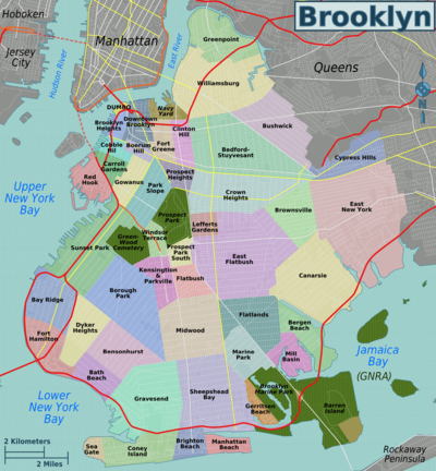
List of Brooklyn, New York neighborhoods
Encyclopedia
These are the neighborhoods of Brooklyn
, one of five borough
s of New York City
, USA
.
Following an 1894 referendum, the entire consolidated City of Brooklyn became a borough of New York City
in 1898.


 Annexed to Brooklyn in 1894.
 Annexed to Brooklyn in 1894.
 Annexed to Brooklyn in 1894.
Brooklyn
Brooklyn is the most populous of New York City's five boroughs, with nearly 2.6 million residents, and the second-largest in area. Since 1896, Brooklyn has had the same boundaries as Kings County, which is now the most populous county in New York State and the second-most densely populated...
, one of five borough
Borough (New York City)
New York City, one of the largest cities in the world, is composed of five boroughs. Each borough now has the same boundaries as the county it is in. County governments were dissolved when the city consolidated in 1898, along with all city, town, and village governments within each county...
s of New York City
New York City
New York is the most populous city in the United States and the center of the New York Metropolitan Area, one of the most populous metropolitan areas in the world. New York exerts a significant impact upon global commerce, finance, media, art, fashion, research, technology, education, and...
, USA
United States
The United States of America is a federal constitutional republic comprising fifty states and a federal district...
.
Northwestern Brooklyn
- Brooklyn HeightsBrooklyn Heights, BrooklynBrooklyn Heights is a culturally diverse neighborhood within the New York City borough of Brooklyn. Originally referred to as 'Brooklyn Village', it has been a prominent area of Brooklyn since 1834. As of 2000, Brooklyn Heights sustained a population of 22,594 people. The neighborhood is part of...
- Brooklyn Navy YardBrooklyn Navy YardThe United States Navy Yard, New York–better known as the Brooklyn Navy Yard or the New York Naval Shipyard –was an American shipyard located in Brooklyn, northeast of the Battery on the East River in Wallabout Basin, a semicircular bend of the river across from Corlear's Hook in Manhattan...
- Admiral's RowAdmiral's RowAdmiral's Row is a row of Second Empire style homes formerly used by naval officers in the New York City borough of Brooklyn at the Brooklyn Navy Yard, and owned by the National Guard. Some of the homes date back to the Civil War. U.S. Navy closed the original Navy Yard in the mid-1960s, it...
- Admiral's Row
- Cadman PlazaCadman PlazaCadman Plaza Park is located on the border between the Brooklyn Heights historic neighborhood and Downtown Brooklyn. It is bounded by Cadman Plaza East and West , and by Brooklyn Bridge on the north and Tillary Street on the south.South of this park, between Tillary and Johnson Streets, lies the...
- Clinton HillClinton Hill, BrooklynClinton Hill is a neighborhood in the north-central portion of the borough of Brooklyn in New York City. It is bordered on the east by Bedford-Stuyvesant, on the west by Fort Greene, on the north by Wallabout Bay and on the south by Prospect Heights...
- Downtown BrooklynDowntown BrooklynDowntown Brooklyn is the third largest central business district in New York City , and is located in the northwestern section of the borough of Brooklyn...
- ATURAAtlantic Terminal Urban Renewal AreaThe Atlantic Terminal Urban Renewal Area is a section of New York City in the downtown area of the borough of Brooklyn, adjacent to the Prospect Heights, Park Slope and Fort Greene neighborhoods, near the Atlantic Terminal train station...
- ATURA
- DUMBODUMBO, BrooklynDumbo, an acronym for Down Under the Manhattan Bridge Overpass, is a neighborhood in the New York City borough of Brooklyn. It encompasses two sections: one located between the Manhattan and Brooklyn Bridges, which connect Brooklyn to Manhattan across the East River, and another that continues...
- Fort GreeneFort Greene, BrooklynFort Greene is a neighborhood in the New York City borough of Brooklyn. Part of Brooklyn Community Board 2, Fort Greene is listed on the New York State Registry and on the National Register of Historic Places, and is a New York City-designated Historic District...
- Fulton FerryFulton Ferry, BrooklynFulton Ferry is a neighborhood in the New York City borough of Brooklyn. The neighborhood is named for a prominent ferry line crossing the East River between Manhattan and Brooklyn, and is also the name of the ferry slip on the Brooklyn side...
- Prospect HeightsProspect Heights, BrooklynProspect Heights is a neighborhood in the northwest of the New York City borough of Brooklyn. The traditional boundaries are Flatbush Avenue to the west, Atlantic Avenue to the north, Eastern Parkway to the south, and Washington Avenue to the east...
- RAMBORAMBO, BrooklynRAMBO refers to a small neighborhood in the downtown area of the New York City borough of Brooklyn. Its borders are Flatbush Avenue Extension on the west, Tillary Street on the south, and the Brooklyn-Queens Expressway on the north and east. The area is also known historically and in city...
- Vinegar HillVinegar Hill, BrooklynVinegar Hill is a neighborhood in the borough of Brooklyn in New York City on the East River waterfront between DUMBO and the Brooklyn Navy Yard. The neighborhood is served by Brooklyn Community Board 2. The neighborhood is served by the NYPD's 84th Precinct....
South Brooklyn
The section of Brooklyn known as South Brooklyn takes its name from its geographical position relative to the original town of Brooklyn, which today includes the neighborhoods listed above under the heading "northwestern Brooklyn." It is not located in the southern part of the modern borough.- Boerum HillBoerum HillBoerum Hill is a small neighborhood in the northwestern portion of the New York City borough of Brooklyn that occupies 36 blocks bounded by State Street to the north, 4th Avenue to the east, Smith Street to the west, and Warren Street to the south. Commercial strips line Smith Street and Atlantic...
- Carroll GardensCarroll Gardens, BrooklynCarroll Gardens is a neighborhood in the New York City borough of Brooklyn, USA. The area is named for Charles Carroll, a revolutionary war veteran who was also the only Roman Catholic signer of the Declaration of Independence...
- Cobble HillCobble Hill, BrooklynCobble Hill is a neighborhood in the New York City borough of Brooklyn, USA. Bordered by Atlantic Avenue on the north, Hicks Street to the west, Smith Street on the east and Degraw Street to the south, Cobble Hill sits adjacent to Boerum Hill and Brooklyn Heights with Carroll Gardens to the south...
- Columbia Street Waterfront District
- GowanusGowanus, BrooklynGowanus is a neighborhood in the New York City borough of Brooklyn. The neighborhood is part of Brooklyn Community Board 6.The Gowanus area has been an active center of industrial and shipping activity since the 1860s...
- Park SlopePark Slope, BrooklynPark Slope is a neighborhood in western Brooklyn, New York City's most populous borough. Park Slope is roughly bounded by Prospect Park West to the east, Fourth Avenue to the west, Flatbush Avenue to the north, and 15th Street to the south, though other definitions are sometimes offered. Generally...
- Red HookRed Hook, BrooklynRed Hook is a neighborhood in the New York City borough of Brooklyn, USA. The neighborhood is part of Brooklyn Community Board 6. It is also the location where the transatlantic liner, the , docks in New York City.- History :...
- South Park SlopeSouth Park SlopeSouth Park Slope, Brooklyn is a neighborhood in Brooklyn, New York. It is sandwiched between Greenwood Heights and Park Slope, bordered by 15th Street to the north, the Prospect Expressway to the south, Fourth Avenue to the west, and Prospect Park West and Green-Wood Cemetery to the east...
- Sunset ParkSunset Park, BrooklynSunset Park is a neighborhood in the western section of the New York City borough of Brooklyn, USA. It is bounded by Greenwood Heights to the north, Borough Park to the east, Bay Ridge to the south, and Upper New York Bay to the west...
- Windsor TerraceWindsor Terrace, BrooklynWindsor Terrace is a neighborhood in the New York City borough of Brooklyn. It is bounded by Prospect Park to the northeast and Green-Wood Cemetery, a National Historic Landmark, to the southwest. Its southeastern boundary is Caton Avenue, while to the northwest it is bordered by Prospect Park West...
Northern Brooklyn
- BushwickBushwick, BrooklynBushwick is a neighborhood in the northern part of the New York City borough of Brooklyn. The neighborhood, formerly Brooklyn's 18th Ward, is now part of Brooklyn Community Board 4...
- Wyckoff HeightsWyckoff Heights, New YorkWyckoff Heights is an area of New York City along the Brooklyn-Queens border in northwest Bushwick / southwest Ridgewood.Wyckoff Heights is home to the Wyckoff Heights Medical Center at Wyckoff Avenue and Stockholm Street , and the former Wyckoff Heights Presbyterian Church at Harman Street and St...
- Wyckoff Heights
- GreenpointGreenpoint, BrooklynGreenpoint is the northernmost neighborhood in the New York City borough of Brooklyn. It is bordered on the southwest by Williamsburg at the Bushwick inlet, on the southeast by the Brooklyn-Queens Expressway and East Williamsburg, on the north by Newtown Creek and Long Island City, Queens at the...
- Little PolandLittle Poland, BrooklynLittle Poland is an informal name for part of a neighborhood in Greenpoint, in the New York City borough of Brooklyn. The name "Little Poland" came to be applied to it following an influx of Polish immigrants after 1900...
- Little Poland
- WilliamsburgWilliamsburg, BrooklynWilliamsburg is a neighborhood in the New York City borough of Brooklyn, bordering Greenpoint to the north, Bedford-Stuyvesant to the south, Bushwick to the east and the East River to the west. The neighborhood is part of Brooklyn Community Board 1. The neighborhood is served by the NYPD's 90th ...
- East WilliamsburgEast Williamsburg, BrooklynEast Williamsburg is a name for the area in the northwestern portion of the borough of Brooklyn in New York City, United States, which lies between Williamsburg, Greenpoint, and Bushwick. Much of this area has been and still is referred to as either Bushwick, Williamsburg, or Greenpoint with the...
- East Williamsburg
- BedfordBedford, BrooklynBedford is a community in the New York City borough of Brooklyn, centered approximately at the corner of modern-day Fulton Street and Franklin Avenue.Its name is better known today as part of the larger community of Bedford-Stuyvesant...
- Bedford-Stuyvesant
Central Brooklyn
- Beverly Square EastBeverly Square East, BrooklynBeverley Square East is a neighborhood in the New York City borough of Brooklyn in the United States. Located on land that remained rural until the early 20th century, the neighborhood consists of many large, free-standing Victorian homes built in the 1900s....
- Beverly Square WestBeverly Square West, BrooklynBeverley Square West is a neighborhood in the New York City borough of Brooklyn. Located on land that remained rural until the early 20th century, the neighborhood consists of many large, free-standing Victorian homes built in the 1900s. The neighborhood was built on farm land originally owned by...
- Crown HeightsCrown Heights, BrooklynCrown Heights is a neighborhood in the central portion of the New York City borough of Brooklyn. The main thoroughfare through this neighborhood is Eastern Parkway, a tree-lined boulevard designed by Frederick Law Olmsted extending two miles east-west.Originally, the area was known as Crow Hill....
- Ditmas ParkDitmas Park, BrooklynDitmas Park is a neighborhood in western Flatbush in the New York City borough of Brooklyn, east of Kensington, and is one of three Flatbush neighborhoods which have been officially designated Historic Districts...
- East FlatbushEast Flatbush, BrooklynEast Flatbush is a neighborhood in the New York City borough of Brooklyn. The area is part of Brooklyn Community Board 17 Though the borders of East Flatbush are highly subjective, its northern border is roughly at Empire Boulevard and East New York Avenue east of East 91st Street, its southern...
- FarragutFarragut, BrooklynFarragut is a neighborhood in the east central section of the New York City borough of Brooklyn. The area is part of Brooklyn Community Board 17...
- Fiske TerraceFiske Terrace, BrooklynFiske Terrace is a planned community and neighborhood in the New York City borough of Brooklyn.Fiske Terrace is located in south central Brooklyn in the southern edge of the community of Flatbush and north of the community of Midwood...
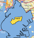
- FlatbushFlatbush, BrooklynFlatbush is a community of the Borough of Brooklyn, a part of New York City, consisting of several neighborhoods.The name Flatbush is an Anglicization of the Dutch language Vlacke bos ....
- KensingtonKensington, BrooklynKensington is a neighborhood in the center of the New York City borough of Brooklyn. It is the area south of Prospect Park and the Green-Wood Cemetery. It is bordered by Coney Island Avenue to the east, Fort Hamilton Parkway and Caton Avenue to the north, McDonald Avenue and 37th Street to the...
- Ocean HillOcean Hill, BrooklynOcean Hill is a subsection of Bedford-Stuyvesant in the New York City borough of Brooklyn. Founded in 1890, the neighborhood is part of Brooklyn Community Board 3 and Brooklyn Community Board 16. The ZIP code for the neighborhood is 11233...
- Ocean ParkwayOcean Parkway (Brooklyn)Ocean Parkway is a broad boulevard in the west central portion of the borough of Brooklyn in New York City.-Route description:Ocean Parkway extends over a distance of about five miles , running almost north to south from the vicinity of Prospect Park to Brighton Beach...
- PigtownPigtown, BrooklynPigtown formerly described a neighborhood in the New York City borough of Brooklyn, existing as such until approximately the end of the 19th century.Pigtown was at the southern periphery of the then City of Brooklyn where it bordered the Town of Flatbush...
- Prospect Lefferts Gardens
- Prospect Park SouthProspect Park South, BrooklynProspect Park South is a neighborhood in the New York City borough of Brooklyn, within the community of Flatbush. It is bordered by Church Avenue to the north, the Brighton Line of the New York City Subway to the east, Beverley Road to the south, and between Stratford Road and Coney Island Avenue...
- Stuyvesant HeightsStuyvesant Heights, BrooklynStuyvesant Heights is a neighborhood in north-central Brooklyn, a part of settled in the mid-17th century before the borough of Brooklyn was incorporated as a city...
- WeeksvilleWeeksville, BrooklynWeeksville is a neighborhood founded by African American freedmen in what is now Brooklyn, New York, United States, part of the present-day neighborhood of Crown Heights.-History:...
- WingateWingate, BrooklynWingate is a neighborhood in the north central portion of the New York City borough of Brooklyn. The area is east of Prospect-Lefferts Gardens and south of Crown Heights. Wingate is bounded by Empire Boulevard to the north, Troy Avenue to the east, Winthrop Street to the south and Nostrand Avenue...
Southwestern Brooklyn
- Bath BeachBath Beach, BrooklynBath Beach is a neighborhood in the New York City Borough of Brooklyn in the United States. It is located at the southwestern edge of the borough on Gravesend Bay.-Geography:...
- Bay RidgeBay Ridge, BrooklynBay Ridge is a neighborhood in the southwest corner of the New York City borough of Brooklyn, USA. It is bounded by Sunset Park on the north, Seventh Avenue and Dyker Heights on the east, The Narrows Strait, which partially houses the Belt Parkway, on the west and 86th Street and Fort Hamilton on...
- BensonhurstBensonhurst, BrooklynBensonhurst is a neighborhood located in the southwestern part of the New York City borough of Brooklyn.-Geography:Sometimes erroneously thought to include all or parts of such neighborhoods as Bath Beach, Dyker Heights, and Borough Park, or to be defined by the streets where the concentration of...
- Borough ParkBorough Park, BrooklynBorough Park , is a neighborhood in the southwestern part of the borough of Brooklyn, in New York City in the United States....
- Dyker HeightsDyker Heights, BrooklynDyker Heights is a residential neighborhood in the southwest corner of the Borough of Brooklyn in New York City, USA. It is sandwiched among Bay Ridge, Bensonhurst, and Gravesend Bay. According to the Post Office, Dyker Heights is bounded to the west by Interstate 278, to the north by Bay Ridge...
- Greenwood HeightsGreenwood Heights, BrooklynGreenwood Heights is a neighborhood in the New York City borough of Brooklyn that takes part of its name from the neighborhood proximity to the Green-Wood Cemetery...
- Fort HamiltonFort Hamilton, BrooklynFort Hamilton is a neighborhood in the far southwestern corner of the New York City borough of Brooklyn. It is located south of, and often considered part of, Bay Ridge. The area stretches from 86th Street as its northern border to 101st Street/the Narrows at the south; it is bounded by New York...
- New UtrechtNew Utrecht, BrooklynNew Utrecht was the last of six towns to be founded in what is today the borough of Brooklyn in New York City. It was named after the city of Utrecht, Netherlands. In 1652 Cornelius van Werckhoven, a surveyor born in Utrecht and a principal investor in the Dutch West India Company, began purchasing...
Southern Brooklyn
- Brighton BeachBrighton BeachBrighton Beach is an oceanside neighborhood in the New York City borough of Brooklyn. As of 2000, it has a population of 75,692 with a total of 31,228 households.-Location:...
, also known as "Little Odessa" - ChinatownChinatown, BrooklynChinatown, Brooklyn, or Brooklyn Chinatown , in the Sunset Park area of the borough of Brooklyn in New York City, is one of the largest and fastest growing ethnic Chinese enclaves outside of Asia, as well as within New York City itself...
- Coney IslandConey IslandConey Island is a peninsula and beach on the Atlantic Ocean in southern Brooklyn, New York, United States. The site was formerly an outer barrier island, but became partially connected to the mainland by landfill....
- Gerritsen BeachGerritsen Beach, BrooklynGerritsen Beach is a small town/community in the New York City borough of Brooklyn, located near Marine Park and Sheepshead Bay. The area is served by Brooklyn Community Board 15.-Geography:...
- GravesendGravesend, BrooklynGravesend is a neighborhood in the south-central section of the New York City borough of Brooklyn, USA.The derivation of the name is unclear. Some speculate that it was named after the English seaport of Gravesend, Kent. An alternative explanation suggests that it was named by Willem Kieft for the...
- HomecrestHomecrest, BrooklynHomecrest is a neighborhood situated in the New York City borough of Brooklyn. It borders Kings Highway to the north, Avenue X to the south, Coney Island Avenue to the west, and Ocean Avenue to the east. Homecrest uses the ZIP Code, 11229. The area is served by Brooklyn Community Board 15...
- MadisonMadison, BrooklynMadison is a purely residential neighborhood in the New York City borough of Brooklyn. Named after its own James Madison High School, it is nestled just east of Homecrest and south of Midwood. Its borders are Kings Highway to the north, Avenue U to the south, Ocean Avenue to the west, and Nostrand...
- Manhattan BeachManhattan Beach, BrooklynManhattan Beach is a residential neighborhood in the New York City borough of Brooklyn. It is bounded by the Atlantic Ocean to the south and east, by Sheepshead Bay on the north, and Brighton Beach to the west. Traditionally known as an Italian and Ashkenazi Jewish neighborhood, it is also home to...
- Mapleton, Grays FarmMapleton, BrooklynMapleton is a neighborhood in Brooklyn, New York City. Mapleton is sometimes mixed up with Bensonhurst or Borough Park According to the website of Public School 48, The Mapleton School, the area was originally part of Borough Park and developed around 1913-1919...
- MidwoodMidwood, BrooklynMidwood is a neighborhood in the south central part of the New York City borough of Brooklyn, New York, USA, roughly halfway between Prospect Park and Coney Island. The neighborhood is within Community District 14...
- Plum BeachPlum Beach, BrooklynPlumb Beach is a beach and surrounding neighborhood along the north shore of Rockaway Inlet, in the New York City borough of Brooklyn. It is located near the neighborhoods of Sheepshead Bay and Gerritsen Beach, just off the Belt Parkway. It is named for the beach plums that grow wild there...
- Sea Gate
- Sheepshead BaySheepshead Bay, BrooklynSheepshead Bay is a bay separating the mainland of Brooklyn, New York City from the eastern portion of Coney Island, the latter originally a barrier island but now effectively an extension of the mainland with peninsulas both east and west...
- White SandsWhite Sands, BrooklynWhite Sands is a tiny and obscure neighborhood in the New York City borough of Brooklyn, located between Coney Island and Bath Beach. It is located in the area of the modern Brooklyn Community Board 13, however most of the former neighborhood no longer exists due to redevelopment.- Geography :White...
Eastern Brooklyn
- BrownsvilleBrownsville, BrooklynBrownsville is a residential neighborhood located in eastern Brooklyn, New York City.The total land area is one square mile, and the ZIP code for the neighborhood is 11212....
- CanarsieCanarsie, BrooklynCanarsie is a neighborhood in the southeastern portion of the borough of Brooklyn, in New York City, United States. The area is part of Brooklyn Community Board 18....
- City LineCity Line, BrooklynCity Line is a sub-section of the East New York neighborhood in Brooklyn, New York City, bordering the neighborhoods of Cypress Hills to the north and Ozone Park, Queens to the east, and the Shore Parkway to the south...
- Cypress HillsCypress Hills, BrooklynCypress Hills is a sub-section of the East New York neighborhood in Brooklyn, New York City, lying north of City Line and south of Cypress Hills Cemetery, in the far northeastern corner of Brooklyn. It is abutted on the west by Bushwick and on the east, across the Brooklyn–Queens border, by...
- East New YorkEast New York, BrooklynEast New York is a residential neighborhood located in the Eastern section of the borough of Brooklyn in New York City, United States. The neighborhood is part of Brooklyn Community Board 5...
- Highland ParkHighland Park, BrooklynHighland Park is a park located on the Brooklyn-Queens border. The name is also applied to the Brooklyn neighborhood to its south, commonly regarded as part of the East NY neighborhood....
- New LotsNew Lots, BrooklynNew Lots is a sub-section of the East New York neighborhood in the eastern part of the New York City borough of Brooklyn. It was known as the Town of New Lots from 1852 when the area seceded from the Town of Flatbush until it was annexed in 1886 as the 26th Ward of Brooklyn. The population is...
- Starrett CityStarrett City, BrooklynStarrett City is a housing development in Brooklyn, New York City. Starrett City opened in 1974, and in 2002, changed its name to the Spring Creek Towers. The neighborhood is part of Brooklyn Community Board 5. Starrett City is patrolled by the NYPD's 75th Precinct.The Starrett City site spanned...
Southeastern Brooklyn
- Barren IslandBarren Island, BrooklynBarren Island was originally an island east of the southern end of the New York City borough of Brooklyn, in Jamaica Bay. The area is separated from the Rockaway Peninsula in Queens by the Rockaway Inlet....
- Bergen BeachBergen Beach, BrooklynBergen Beach is a neighborhood in the New York City borough of Brooklyn. The area is part of Brooklyn Community Board 18.What is now Bergen Beach was an island off the coast of Canarsie that was connected to the mainland in the early 1900s using landfill....
- FlatlandsFlatlands, BrooklynFlatlands is a neighborhood in the New York City borough of Brooklyn. The area is part of Brooklyn Community Board 18.One of the original five Dutch towns on Long Island , this neighborhood was originally known as Nieuw Amersfoort, after the Dutch city of Amersfoort, but the name was changed to...
- GeorgetownGeorgetown, BrooklynGeorgetown is a small neighborhood east of Ralph Avenue in the New York City borough of Brooklyn. The area is part of Brooklyn Community Board 18....
- Marine ParkMarine ParkMarine Park is a neighborhood located in the New York City borough of Brooklyn, that lies between Mill Basin and Gerritsen Beach. The neighborhood is mostly squared off in area by Gerritsen Avenue, Flatbush Avenue, Avenue U and Kings Highway. It partly surrounds the eponymous park. The neighborhood...
- Mill BasinMill Basin, BrooklynMill Basin is a neighborhood in New York City in the southern portion of the borough of Brooklyn lying along Jamaica Bay and bounded to the north by Avenue U, and to the east, south, and west by the Mill Basin/Mill Island Inlet...
List of neighborhoods by historical town
The original Dutch settlement of what is now Brooklyn consisted of six towns with clearly defined borders. These later became English settlements, and were consolidated over time until the entirety of Kings County was the unified City of Brooklyn. The towns were, clockwise from the north: Bushwick, Brooklyn, Flatlands, Gravesend, New Utrecht, with Flatbush in the middle. The modern neighborhoods bearing these names are located roughly in the center of each of these original towns. Certain portions of the original six towns were also independent municipalities for a time, before being reabsorbed.Following an 1894 referendum, the entire consolidated City of Brooklyn became a borough of New York City
New York City
New York is the most populous city in the United States and the center of the New York Metropolitan Area, one of the most populous metropolitan areas in the world. New York exerts a significant impact upon global commerce, finance, media, art, fashion, research, technology, education, and...
in 1898.
Bushwick
Annexed to Brooklyn in 1854.- BushwickBushwick, BrooklynBushwick is a neighborhood in the northern part of the New York City borough of Brooklyn. The neighborhood, formerly Brooklyn's 18th Ward, is now part of Brooklyn Community Board 4...
- GreenpointGreenpoint, BrooklynGreenpoint is the northernmost neighborhood in the New York City borough of Brooklyn. It is bordered on the southwest by Williamsburg at the Bushwick inlet, on the southeast by the Brooklyn-Queens Expressway and East Williamsburg, on the north by Newtown Creek and Long Island City, Queens at the...
- WilliamsburgWilliamsburg, BrooklynWilliamsburg is a neighborhood in the New York City borough of Brooklyn, bordering Greenpoint to the north, Bedford-Stuyvesant to the south, Bushwick to the east and the East River to the west. The neighborhood is part of Brooklyn Community Board 1. The neighborhood is served by the NYPD's 90th ...
(separated from Bushwick in 1840, annexed to Brooklyn in 1854)
Brooklyn
- Bedford-Stuyvesant
- Boerum Hill
- Carroll GardensCarroll Gardens, BrooklynCarroll Gardens is a neighborhood in the New York City borough of Brooklyn, USA. The area is named for Charles Carroll, a revolutionary war veteran who was also the only Roman Catholic signer of the Declaration of Independence...
- Cobble HillCobble Hill, BrooklynCobble Hill is a neighborhood in the New York City borough of Brooklyn, USA. Bordered by Atlantic Avenue on the north, Hicks Street to the west, Smith Street on the east and Degraw Street to the south, Cobble Hill sits adjacent to Boerum Hill and Brooklyn Heights with Carroll Gardens to the south...
- Brooklyn HeightsBrooklyn Heights, BrooklynBrooklyn Heights is a culturally diverse neighborhood within the New York City borough of Brooklyn. Originally referred to as 'Brooklyn Village', it has been a prominent area of Brooklyn since 1834. As of 2000, Brooklyn Heights sustained a population of 22,594 people. The neighborhood is part of...
- BrownsvilleBrownsville, BrooklynBrownsville is a residential neighborhood located in eastern Brooklyn, New York City.The total land area is one square mile, and the ZIP code for the neighborhood is 11212....
- City LineCity Line, BrooklynCity Line is a sub-section of the East New York neighborhood in Brooklyn, New York City, bordering the neighborhoods of Cypress Hills to the north and Ozone Park, Queens to the east, and the Shore Parkway to the south...
- Clinton HillClinton Hill, BrooklynClinton Hill is a neighborhood in the north-central portion of the borough of Brooklyn in New York City. It is bordered on the east by Bedford-Stuyvesant, on the west by Fort Greene, on the north by Wallabout Bay and on the south by Prospect Heights...
- Crown HeightsCrown Heights, BrooklynCrown Heights is a neighborhood in the central portion of the New York City borough of Brooklyn. The main thoroughfare through this neighborhood is Eastern Parkway, a tree-lined boulevard designed by Frederick Law Olmsted extending two miles east-west.Originally, the area was known as Crow Hill....
- Cypress HillsCypress Hills, BrooklynCypress Hills is a sub-section of the East New York neighborhood in Brooklyn, New York City, lying north of City Line and south of Cypress Hills Cemetery, in the far northeastern corner of Brooklyn. It is abutted on the west by Bushwick and on the east, across the Brooklyn–Queens border, by...
- Downtown BrooklynDowntown BrooklynDowntown Brooklyn is the third largest central business district in New York City , and is located in the northwestern section of the borough of Brooklyn...
- DUMBODUMBO, BrooklynDumbo, an acronym for Down Under the Manhattan Bridge Overpass, is a neighborhood in the New York City borough of Brooklyn. It encompasses two sections: one located between the Manhattan and Brooklyn Bridges, which connect Brooklyn to Manhattan across the East River, and another that continues...
- East New YorkEast New York, BrooklynEast New York is a residential neighborhood located in the Eastern section of the borough of Brooklyn in New York City, United States. The neighborhood is part of Brooklyn Community Board 5...
- Fort GreeneFort Greene, BrooklynFort Greene is a neighborhood in the New York City borough of Brooklyn. Part of Brooklyn Community Board 2, Fort Greene is listed on the New York State Registry and on the National Register of Historic Places, and is a New York City-designated Historic District...
- GowanusGowanus, BrooklynGowanus is a neighborhood in the New York City borough of Brooklyn. The neighborhood is part of Brooklyn Community Board 6.The Gowanus area has been an active center of industrial and shipping activity since the 1860s...
- Greenwood HeightsGreenwood Heights, BrooklynGreenwood Heights is a neighborhood in the New York City borough of Brooklyn that takes part of its name from the neighborhood proximity to the Green-Wood Cemetery...
- Highland ParkHighland Park, BrooklynHighland Park is a park located on the Brooklyn-Queens border. The name is also applied to the Brooklyn neighborhood to its south, commonly regarded as part of the East NY neighborhood....
- New LotsNew Lots, BrooklynNew Lots is a sub-section of the East New York neighborhood in the eastern part of the New York City borough of Brooklyn. It was known as the Town of New Lots from 1852 when the area seceded from the Town of Flatbush until it was annexed in 1886 as the 26th Ward of Brooklyn. The population is...
(separated from Flatbush in 1852, annexed to Brooklyn in 1886) - Ocean HillOcean Hill, BrooklynOcean Hill is a subsection of Bedford-Stuyvesant in the New York City borough of Brooklyn. Founded in 1890, the neighborhood is part of Brooklyn Community Board 3 and Brooklyn Community Board 16. The ZIP code for the neighborhood is 11233...
- Park SlopePark Slope, BrooklynPark Slope is a neighborhood in western Brooklyn, New York City's most populous borough. Park Slope is roughly bounded by Prospect Park West to the east, Fourth Avenue to the west, Flatbush Avenue to the north, and 15th Street to the south, though other definitions are sometimes offered. Generally...
- Prospect HeightsProspect Heights, BrooklynProspect Heights is a neighborhood in the northwest of the New York City borough of Brooklyn. The traditional boundaries are Flatbush Avenue to the west, Atlantic Avenue to the north, Eastern Parkway to the south, and Washington Avenue to the east...
- RAMBORAMBO, BrooklynRAMBO refers to a small neighborhood in the downtown area of the New York City borough of Brooklyn. Its borders are Flatbush Avenue Extension on the west, Tillary Street on the south, and the Brooklyn-Queens Expressway on the north and east. The area is also known historically and in city...
- Spring Creek
- Starrett CityStarrett City, BrooklynStarrett City is a housing development in Brooklyn, New York City. Starrett City opened in 1974, and in 2002, changed its name to the Spring Creek Towers. The neighborhood is part of Brooklyn Community Board 5. Starrett City is patrolled by the NYPD's 75th Precinct.The Starrett City site spanned...
- Stuyvesant HeightsStuyvesant Heights, BrooklynStuyvesant Heights is a neighborhood in north-central Brooklyn, a part of settled in the mid-17th century before the borough of Brooklyn was incorporated as a city...
- Sunset ParkSunset Park, BrooklynSunset Park is a neighborhood in the western section of the New York City borough of Brooklyn, USA. It is bounded by Greenwood Heights to the north, Borough Park to the east, Bay Ridge to the south, and Upper New York Bay to the west...
- Vinegar HillVinegar Hill, BrooklynVinegar Hill is a neighborhood in the borough of Brooklyn in New York City on the East River waterfront between DUMBO and the Brooklyn Navy Yard. The neighborhood is served by Brooklyn Community Board 2. The neighborhood is served by the NYPD's 84th Precinct....
- WeeksvilleWeeksville, BrooklynWeeksville is a neighborhood founded by African American freedmen in what is now Brooklyn, New York, United States, part of the present-day neighborhood of Crown Heights.-History:...
- Windsor TerraceWindsor Terrace, BrooklynWindsor Terrace is a neighborhood in the New York City borough of Brooklyn. It is bounded by Prospect Park to the northeast and Green-Wood Cemetery, a National Historic Landmark, to the southwest. Its southeastern boundary is Caton Avenue, while to the northwest it is bordered by Prospect Park West...
- WingateWingate, BrooklynWingate is a neighborhood in the north central portion of the New York City borough of Brooklyn. The area is east of Prospect-Lefferts Gardens and south of Crown Heights. Wingate is bounded by Empire Boulevard to the north, Troy Avenue to the east, Winthrop Street to the south and Nostrand Avenue...
Flatlands
Annexed to Brooklyn in 1896.- Bergen BeachBergen Beach, BrooklynBergen Beach is a neighborhood in the New York City borough of Brooklyn. The area is part of Brooklyn Community Board 18.What is now Bergen Beach was an island off the coast of Canarsie that was connected to the mainland in the early 1900s using landfill....
- CanarsieCanarsie, BrooklynCanarsie is a neighborhood in the southeastern portion of the borough of Brooklyn, in New York City, United States. The area is part of Brooklyn Community Board 18....
- FlatlandsFlatlands, BrooklynFlatlands is a neighborhood in the New York City borough of Brooklyn. The area is part of Brooklyn Community Board 18.One of the original five Dutch towns on Long Island , this neighborhood was originally known as Nieuw Amersfoort, after the Dutch city of Amersfoort, but the name was changed to...
- GeorgetownGeorgetown, BrooklynGeorgetown is a small neighborhood east of Ralph Avenue in the New York City borough of Brooklyn. The area is part of Brooklyn Community Board 18....
- Marine ParkMarine ParkMarine Park is a neighborhood located in the New York City borough of Brooklyn, that lies between Mill Basin and Gerritsen Beach. The neighborhood is mostly squared off in area by Gerritsen Avenue, Flatbush Avenue, Avenue U and Kings Highway. It partly surrounds the eponymous park. The neighborhood...
- Mill BasinMill Basin, BrooklynMill Basin is a neighborhood in New York City in the southern portion of the borough of Brooklyn lying along Jamaica Bay and bounded to the north by Avenue U, and to the east, south, and west by the Mill Basin/Mill Island Inlet...
- The southeastern quarter of MidwoodMidwood, BrooklynMidwood is a neighborhood in the south central part of the New York City borough of Brooklyn, New York, USA, roughly halfway between Prospect Park and Coney Island. The neighborhood is within Community District 14...
Gravesend
- Brighton BeachBrighton BeachBrighton Beach is an oceanside neighborhood in the New York City borough of Brooklyn. As of 2000, it has a population of 75,692 with a total of 31,228 households.-Location:...
- Coney IslandConey IslandConey Island is a peninsula and beach on the Atlantic Ocean in southern Brooklyn, New York, United States. The site was formerly an outer barrier island, but became partially connected to the mainland by landfill....
- Gerritsen BeachGerritsen Beach, BrooklynGerritsen Beach is a small town/community in the New York City borough of Brooklyn, located near Marine Park and Sheepshead Bay. The area is served by Brooklyn Community Board 15.-Geography:...
- GravesendGravesend, BrooklynGravesend is a neighborhood in the south-central section of the New York City borough of Brooklyn, USA.The derivation of the name is unclear. Some speculate that it was named after the English seaport of Gravesend, Kent. An alternative explanation suggests that it was named by Willem Kieft for the...
- HomecrestHomecrest, BrooklynHomecrest is a neighborhood situated in the New York City borough of Brooklyn. It borders Kings Highway to the north, Avenue X to the south, Coney Island Avenue to the west, and Ocean Avenue to the east. Homecrest uses the ZIP Code, 11229. The area is served by Brooklyn Community Board 15...
- MadisonMadison, BrooklynMadison is a purely residential neighborhood in the New York City borough of Brooklyn. Named after its own James Madison High School, it is nestled just east of Homecrest and south of Midwood. Its borders are Kings Highway to the north, Avenue U to the south, Ocean Avenue to the west, and Nostrand...
- Manhattan BeachManhattan Beach, BrooklynManhattan Beach is a residential neighborhood in the New York City borough of Brooklyn. It is bounded by the Atlantic Ocean to the south and east, by Sheepshead Bay on the north, and Brighton Beach to the west. Traditionally known as an Italian and Ashkenazi Jewish neighborhood, it is also home to...
- Plum BeachPlum Beach, BrooklynPlumb Beach is a beach and surrounding neighborhood along the north shore of Rockaway Inlet, in the New York City borough of Brooklyn. It is located near the neighborhoods of Sheepshead Bay and Gerritsen Beach, just off the Belt Parkway. It is named for the beach plums that grow wild there...
- Seagate
- Sheepshead BaySheepshead Bay, BrooklynSheepshead Bay is a bay separating the mainland of Brooklyn, New York City from the eastern portion of Coney Island, the latter originally a barrier island but now effectively an extension of the mainland with peninsulas both east and west...
- The southeastern half of Bath BeachBath Beach, BrooklynBath Beach is a neighborhood in the New York City Borough of Brooklyn in the United States. It is located at the southwestern edge of the borough on Gravesend Bay.-Geography:...
- The southeastern half of BensonhurstBensonhurst, BrooklynBensonhurst is a neighborhood located in the southwestern part of the New York City borough of Brooklyn.-Geography:Sometimes erroneously thought to include all or parts of such neighborhoods as Bath Beach, Dyker Heights, and Borough Park, or to be defined by the streets where the concentration of...
- The southwestern quarter of MidwoodMidwood, BrooklynMidwood is a neighborhood in the south central part of the New York City borough of Brooklyn, New York, USA, roughly halfway between Prospect Park and Coney Island. The neighborhood is within Community District 14...
New Utrecht
- Bay RidgeBay Ridge, BrooklynBay Ridge is a neighborhood in the southwest corner of the New York City borough of Brooklyn, USA. It is bounded by Sunset Park on the north, Seventh Avenue and Dyker Heights on the east, The Narrows Strait, which partially houses the Belt Parkway, on the west and 86th Street and Fort Hamilton on...
- Borough ParkBorough Park, BrooklynBorough Park , is a neighborhood in the southwestern part of the borough of Brooklyn, in New York City in the United States....
- Dyker HeightsDyker Heights, BrooklynDyker Heights is a residential neighborhood in the southwest corner of the Borough of Brooklyn in New York City, USA. It is sandwiched among Bay Ridge, Bensonhurst, and Gravesend Bay. According to the Post Office, Dyker Heights is bounded to the west by Interstate 278, to the north by Bay Ridge...
- Fort HamiltonFort Hamilton, BrooklynFort Hamilton is a neighborhood in the far southwestern corner of the New York City borough of Brooklyn. It is located south of, and often considered part of, Bay Ridge. The area stretches from 86th Street as its northern border to 101st Street/the Narrows at the south; it is bounded by New York...
- New UtrechtNew Utrecht, BrooklynNew Utrecht was the last of six towns to be founded in what is today the borough of Brooklyn in New York City. It was named after the city of Utrecht, Netherlands. In 1652 Cornelius van Werckhoven, a surveyor born in Utrecht and a principal investor in the Dutch West India Company, began purchasing...
- The northwestern half of Bath BeachBath Beach, BrooklynBath Beach is a neighborhood in the New York City Borough of Brooklyn in the United States. It is located at the southwestern edge of the borough on Gravesend Bay.-Geography:...
- The northwestern half of BensonhurstBensonhurst, BrooklynBensonhurst is a neighborhood located in the southwestern part of the New York City borough of Brooklyn.-Geography:Sometimes erroneously thought to include all or parts of such neighborhoods as Bath Beach, Dyker Heights, and Borough Park, or to be defined by the streets where the concentration of...
Flatbush
- Ditmas ParkDitmas Park, BrooklynDitmas Park is a neighborhood in western Flatbush in the New York City borough of Brooklyn, east of Kensington, and is one of three Flatbush neighborhoods which have been officially designated Historic Districts...
- East FlatbushEast Flatbush, BrooklynEast Flatbush is a neighborhood in the New York City borough of Brooklyn. The area is part of Brooklyn Community Board 17 Though the borders of East Flatbush are highly subjective, its northern border is roughly at Empire Boulevard and East New York Avenue east of East 91st Street, its southern...
- FarragutFarragut, BrooklynFarragut is a neighborhood in the east central section of the New York City borough of Brooklyn. The area is part of Brooklyn Community Board 17...
- Fiske TerraceFiske Terrace, BrooklynFiske Terrace is a planned community and neighborhood in the New York City borough of Brooklyn.Fiske Terrace is located in south central Brooklyn in the southern edge of the community of Flatbush and north of the community of Midwood...
- FlatbushFlatbush, BrooklynFlatbush is a community of the Borough of Brooklyn, a part of New York City, consisting of several neighborhoods.The name Flatbush is an Anglicization of the Dutch language Vlacke bos ....
- KensingtonKensington, BrooklynKensington is a neighborhood in the center of the New York City borough of Brooklyn. It is the area south of Prospect Park and the Green-Wood Cemetery. It is bordered by Coney Island Avenue to the east, Fort Hamilton Parkway and Caton Avenue to the north, McDonald Avenue and 37th Street to the...
- Prospect Lefferts Gardens
- Prospect Park SouthProspect Park South, BrooklynProspect Park South is a neighborhood in the New York City borough of Brooklyn, within the community of Flatbush. It is bordered by Church Avenue to the north, the Brighton Line of the New York City Subway to the east, Beverley Road to the south, and between Stratford Road and Coney Island Avenue...
- The northern half of MidwoodMidwood, BrooklynMidwood is a neighborhood in the south central part of the New York City borough of Brooklyn, New York, USA, roughly halfway between Prospect Park and Coney Island. The neighborhood is within Community District 14...
See also
- List of Bronx neighborhoods
- List of Manhattan neighborhoods
- List of Queens neighborhoods
- List of Staten Island neighborhoods