

List of Arizona hurricanes
Encyclopedia

Arizona
Arizona ; is a state located in the southwestern region of the United States. It is also part of the western United States and the mountain west. The capital and largest city is Phoenix...
has been affected by hurricanes
Tropical cyclone
A tropical cyclone is a storm system characterized by a large low-pressure center and numerous thunderstorms that produce strong winds and heavy rain. Tropical cyclones strengthen when water evaporated from the ocean is released as the saturated air rises, resulting in condensation of water vapor...
on numerous occasions. Usually, these storms originate in the eastern Pacific Ocean, make landfall in the Mexican
Mexico
The United Mexican States , commonly known as Mexico , is a federal constitutional republic in North America. It is bordered on the north by the United States; on the south and west by the Pacific Ocean; on the southeast by Guatemala, Belize, and the Caribbean Sea; and on the east by the Gulf of...
states of Baja California
Baja California
Baja California officially Estado Libre y Soberano de Baja California is one of the 31 states which, with the Federal District, comprise the 32 Federal Entities of Mexico. It is both the northernmost and westernmost state of Mexico. Before becoming a state in 1953, the area was known as the North...
or Sonora
Sonora
Sonora officially Estado Libre y Soberano de Sonora is one of the 31 states which, with the Federal District, comprise the 32 Federal Entities of Mexico. It is divided into 72 municipalities; the capital city is Hermosillo....
, and dissipate before crossing into the United States. Thus, in most cases, it is only the tropical cyclones' remnant moisture that produces heavy rainfall—and in some occasions, flooding—in portions of Arizona. However, approximately every five years, a tropical cyclone retains sufficient strength to enter the state as a tropical storm or a tropical depression. Arizonans can expect indirect flash flood
Flash flood
A flash flood is a rapid flooding of geomorphic low-lying areas—washes, rivers, dry lakes and basins. It may be caused by heavy rain associated with a storm, hurricane, or tropical storm or meltwater from ice or snow flowing over ice sheets or snowfields...
s caused by the remnants of tropical cyclones to occur about every two years.
Tropical cyclones in Arizona are not common, since the predominant wind pattern
Trade wind
The trade winds are the prevailing pattern of easterly surface winds found in the tropics, within the lower portion of the Earth's atmosphere, in the lower section of the troposphere near the Earth's equator...
steers most storms that form in the Eastern Pacific either parallel or away from the Pacific coast of northwestern Mexico. As a result, most storms that could affect Arizona are carried away from the United States, with only 6% of all Pacific hurricanes entering US territory. Not all Arizona hurricanes originate from the Pacific Ocean, however; an Atlantic hurricane in 2008 produced rainfall in the eastern portion of the state, and another Atlantic storm reached Arizona as a tropical depression. Many, but not all, of these systems also impacted California.
Despite their rarity, hurricanes are among Arizona's most significant weather makers. In years when Arizona is affected by a tropical cyclone, these can be responsible for up to 25% of the rainfall in areas along the Colorado River
Colorado River
The Colorado River , is a river in the Southwestern United States and northwestern Mexico, approximately long, draining a part of the arid regions on the western slope of the Rocky Mountains. The watershed of the Colorado River covers in parts of seven U.S. states and two Mexican states...
. Arizona hurricanes are also responsible for torrential rains in localized areas, with the state's 24-hour rainfall record—11.97 inches (304 mm) of precipitation—occurring during Hurricane Nora
Hurricane Nora (1997)
Hurricane Nora was only the third tropical cyclone on record to reach Arizona as a tropical storm. Nora was the fourteenth named tropical cyclone and seventh hurricane of the 1997 Pacific hurricane season...
's landfall
Landfall (meteorology)
Landfall is the event of a tropical cyclone or a waterspout coming onto land after being over water. When a waterspout makes landfall it is reclassified as a tornado, which can then cause damage inland...
in 1997. The heavy rainfall can trigger extensive flash floods, such as the ones produced by the remnants of Tropical Storm Octave
October 1983 Southwest United States floods
October 1983 Southwest United States floods was a flood that most significantly impacted Arizona and New Mexico. It occurred through the interaction of the remnants of Pacific tropical storm Octave, as well as a stalled low pressure area off the west coast of California. The combination contributed...
in 1983, or the lingering moisture from Tropical Storm Emilia
Tropical Storm Emilia (2006)
Tropical Storm Emilia was a rare tropical cyclone that affected the Baja California peninsula in July 2006. The sixth tropical depression and fifth tropical storm of the 2006 Pacific hurricane season, it developed on July 21 about 400 miles off the coast of Mexico...
in 2006.
Climatology
Tropical cyclones are not common over Arizona, but on average, a tropical storm or a tropical depression enters the state approximately every five years. However, indirect flash floodFlash flood
A flash flood is a rapid flooding of geomorphic low-lying areas—washes, rivers, dry lakes and basins. It may be caused by heavy rain associated with a storm, hurricane, or tropical storm or meltwater from ice or snow flowing over ice sheets or snowfields...
s caused by the remnants of tropical cyclones are more common, as they tend to occur about every two years.
Storms that approach the southwestern United States, and by extension Arizona, generally form closer to the Mexican shoreline than average, making them more likely to recurve northwards under the influence of an approaching trough
Trough (meteorology)
A trough is an elongated region of relatively low atmospheric pressure, often associated with fronts.Unlike fronts, there is not a universal symbol for a trough on a weather chart. The weather charts in some countries or regions mark troughs by a line. In the United States, a trough may be marked...
. These troughs tend to extend farther to the south during the latter part of the Pacific hurricane season, in the period between late August and early October. These pronounced troughs thus produce a synoptic-scale flow that is conducive to steering hurricanes towards the southwestern United States.
The infusions of tropical moisture from Arizona-bound tropical cyclones can be a significant portion of the rainfall in the region. In years when hurricanes approach Arizona, eastern and northern portions of the state receive on average 6–8% of the monsoon-season
North American Monsoon
The North American monsoon, variously known as the Southwest United States monsoon, the Mexican monsoon, or the Arizona monsoon, is experienced as a pronounced increase in rainfall from an extremely dry June to a rainy July over large areas of the southwestern United States and northwestern Mexico...
precipitation from tropical systems and their remnants. This percentage rises towards the southwestern corner of the state, which can receive up to a quarter of its monsoon-season rainfall from tropical cyclones.
Storms
Tropical storms are one of Arizona's main sources of rainfall, as they infuse the monsoon over the southwestern United StatesNorth American Monsoon
The North American monsoon, variously known as the Southwest United States monsoon, the Mexican monsoon, or the Arizona monsoon, is experienced as a pronounced increase in rainfall from an extremely dry June to a rainy July over large areas of the southwestern United States and northwestern Mexico...
with moisture, producing large-scale floods in occasions. However, all of the storms that have impacted Arizona have formed in the latter parts of the Pacific hurricane season, and only storm remnants have affected the state before August.
| Storm | Peak intensity Saffir-Simpson Hurricane Scale The Saffir–Simpson Hurricane Scale , or the Saffir–Simpson Hurricane Wind Scale , classifies hurricanes — Western Hemisphere tropical cyclones that exceed the intensities of tropical depressions and tropical storms — into five categories distinguished by the intensities of their sustained winds... |
Season | Intensity | Date |
|---|---|---|---|---|
| Unnamed | 0 Unknown | 1921 | 1 Remnant low | |
| Unnamed | 0 Unknown | 1921 | 10 Tropical depression | |
| Unnamed | 0 Unknown | 1926 | 1 Remnant low | |
| Unnamed | 0 Unknown | 1927 | 1 Remnant low | |
| One | 100 Category 1 | 1929 1929 Atlantic hurricane season The 1929 Atlantic hurricane season ran through the summer and the first half of fall in 1929. It was a mostly quiet season in the Atlantic as only five tropical cyclones formed during the season, with the distance between the first and second storms being nearly three months... |
20 Tropical depression | |
| Unnamed | 0 Unknown | 1935 | 20 Tropical storm | |
| Unnamed | 20 Tropical storm | 1951 | 20 Tropical storm | |
| Unnamed | 100 Category 1 | 1958 | 20 Tropical storm | |
| Claudia | 20 Tropical storm | 1962 | 20 Tropical storm | |
| Tillie | 20 Tropical storm | 1964 | 1 Remnant low | |
| Emily | 100 Category 1 | 1965 | 1 Remnant low | |
| Kirsten | 20 Tropical storm | 1967 | 1 Remnant low | |
| Katrina | 100 Category 1 | 1967 | 20 Tropical storm | |
| Hyacinth | 20 Tropical storm | 1968 | 10 Tropical depression | |
| Pauline Hurricane Pauline (1968) Hurricane Pauline was the deadliest hurricane of the 1968 Pacific hurricane season. Forming from a disturbance in the Intertropical Convergence Zone on September 26 and becoming a tropical storm on September 29, the hurricane strengthened to a peak of as a Category 1 hurricane on... |
100 Category 1 | 1968 | 1 Remnant low | |
| Norma Tropical Storm Norma (1970) Tropical Storm Norma was the fourteenth named tropical cyclone of the 1970 Pacific hurricane season. The storm formed off the coast of Mexico and intensified rapidly, peaking as a strong tropical storm on September 3 before starting a weakening trend which saw it dissipate before making landfall on... |
20 Tropical storm | 1970 | 1 Remnant low | |
| Irene-Olivia Hurricane Irene–Olivia Hurricane Irene–Olivia was the first actively tracked tropical cyclone which moved into the eastern Pacific Ocean from the Atlantic basin. It originated as a tropical depression on September 11, 1971, in the tropical Atlantic. The cyclone tracked nearly due westward at a low latitude, passing... |
300 Category 3 | 1971 | 1 Remnant low | |
| Joanne | 200 Category 2 | 1972 | 10 Tropical storm | |
| Kathleen Hurricane Kathleen (1976) Hurricane Kathleen was a hurricane of the 1976 Pacific hurricane season that caused destructive impacts in California. Kathleen caused widespread flooding and damage in northern Mexico and parts of the southwestern United States. It also took an unusual path. On September 7, a tropical depression... |
100 Category 1 | 1976 | 20 Tropical storm | |
| Liza Hurricane Liza (1976) Hurricane Liza was one of the deadliest East Pacific tropical cyclones on record. The seventeenth tropical cyclone, thirteenth named storm, and the eight hurricane of the 1976 Pacific hurricane season, Liza developed from an area of disturbed weather to the southwest of Mexico on September 25... |
400 Category 4 | 1976 | 1 Remnant low | |
| Doreen | 100 Category 1 | 1977 | 20 Tropical storm | |
| Heather | 100 Category 1 | 1977 | 10 Tropical depression | |
| Octave | 20 Tropical storm | 1983 | 20 Tropical storm | |
| Norbert | 400 Category 4 | 1984 | 10 Tropical depression | |
| Polo | 300 Category 3 | 1984 | 1 Remnant low | |
| Raymond | 300 Category 3 | 1989 | 10 Tropical depression | |
| Boris | 100 Category 1 | 1990 | 1 Remnant low | |
| Lester Hurricane Lester (1992) Hurricane Lester was the first Pacific tropical cyclone to enter the United States as a tropical storm since 1967. The twelfth named storm and seventh hurricane of the 1992 Pacific hurricane season, Lester formed on August 20 from a tropical wave southwest of Mexico. The tropical storm moved... |
100 Category 1 | 1992 | 20 Tropical storm | |
| Hilary | 300 Category 3 | 1993 | 1 Remnant low | |
| Flossie | 100 Category 1 | 1995 | 1 Remnant low | |
| Ismael Hurricane Ismael Hurricane Ismael was a weak, but deadly Pacific hurricane that killed over one hundred people in northern Mexico in September of the 1995 Pacific hurricane season. It developed from a persistent area of deep convection on September 12, and steadily strengthened as it moved to the north-northwest... |
100 Category 1 | 1995 | 1 Remnant low | |
| Nora Hurricane Nora (1997) Hurricane Nora was only the third tropical cyclone on record to reach Arizona as a tropical storm. Nora was the fourteenth named tropical cyclone and seventh hurricane of the 1997 Pacific hurricane season... |
400 Category 4 | 1997 | 20 Tropical storm | |
| Frank | 20 Tropical storm | 1998 | 1 Remnant low | |
| Isis Hurricane Isis (1998) Hurricane Isis was the deadliest tropical cyclone and only hurricane to make landfall during the 1998 Pacific hurricane season. The ninth tropical storm and sixth hurricane of the season, Isis developed on September 1 from the interaction between a tropical wave and a large surface circulation to... |
100 Category 1 | 1998 | 1 Remnant low | |
| Olivia | 20 Tropical storm | 2000 | 1 Remnant low | |
| Juliette Hurricane Juliette (2001) Hurricane Juliette was a long lasting Category 4 hurricane in the 2001 Pacific hurricane season. It caused 12 deaths and $400 million in damage when it hit Baja California in late September.-Meteorological history:... |
400 Category 4 | 2001 | 1 Remnant low | |
| Ignacio Hurricane Ignacio (2003) Hurricane Ignacio was the latest-forming first hurricane of a Pacific hurricane season since reliable satellite observation began in 1966. The ninth tropical storm of the 2003 Pacific hurricane season, Ignacio developed out of a tropical wave on August 22 a short distance off the coast of Mexico... |
200 Category 2 | 2003 | 1 Remnant low | |
| Marty Hurricane Marty (2003) Hurricane Marty was the deadliest tropical cyclone of the 2003 Pacific hurricane season. Forming on September 18, it became the 13th tropical storm and fourth hurricane of the year... |
200 Category 2 | 2003 | 1 Remnant low | |
| Javier Hurricane Javier (2004) Hurricane Javier was the tenth named storm and the sixth and final hurricane of the 2004 Pacific hurricane season. Javier was also the strongest hurricane of the 2004 season, with 150 mph winds and a central pressure of 930 millibars... |
400 Category 4 | 2004 | 1 Remnant low | |
| Emilia Tropical Storm Emilia (2006) Tropical Storm Emilia was a rare tropical cyclone that affected the Baja California peninsula in July 2006. The sixth tropical depression and fifth tropical storm of the 2006 Pacific hurricane season, it developed on July 21 about 400 miles off the coast of Mexico... |
20 Tropical storm | 2006 | 1 Remnant low | |
| John Hurricane John (2006) Hurricane John was the eleventh named storm, seventh hurricane, and fifth major hurricane of the 2006 Pacific hurricane season. Hurricane John developed on August 28 from a tropical wave to the south of Mexico. Favorable conditions allowed the storm to intensify quickly, and it attained peak winds... |
400 Category 4 | 2006 | 1 Remnant low | |
| Henriette Hurricane Henriette (2007) Hurricane Henriette was the deadliest tropical cyclone of the 2007 Pacific hurricane season. The storm, which caused nine fatalities, formed from an area of disturbed weather on August 30, 2007, and became a tropical storm the next day. The cyclone moved parallel to the Mexican Pacific coast, but... |
100 Category 1 | 2007 | 1 Remnant low | |
| Dolly Hurricane Dolly (2008) Hurricane Dolly was a tropical cyclone that made landfall in extreme southern Texas in July 2008. Dolly was the fourth tropical cyclone and second hurricane to form during the 2008 Atlantic hurricane season. It was the first U.S. landfalling hurricane of the 2008 season. Dolly developed on July 20... |
200 Category 2 | 2008 2008 Atlantic hurricane season The 2008 Atlantic hurricane season was a very active hurricane season with sixteen named storms formed, including eight that became hurricanes and five that became major hurricanes. The season officially started on June 1 and ended on November 30. These dates conventionally delimit the period of... |
1 Remnant low | |
| Julio Tropical Storm Julio (2008) Tropical Storm Julio was a tropical storm that made landfall on the southern tip of Baja California Sur in August 2008. The tenth named storm of the 2008 Pacific hurricane season, it developed from a tropical wave on August 23 off the coast of Mexico. It moved parallel to the coast, reaching peak... |
20 Tropical storm | 2008 | 1 Remnant low | |
| Jimena Hurricane Jimena (2009) Hurricane Jimena was a Category 4 storm that is tied with Hurricane Norbert as the strongest tropical cyclone to make landfall on western Baja California. Forming from a tropical wave late on August 28, off Mexico's Pacific coast, the system rapidly intensified into a Category 2... |
400 Category 4 | 2009 | 1 Remnant low |
Storm systems
| Precipitation | Storm | Measurement station |
|||
|---|---|---|---|---|---|
| Rank | (mm) | (in) | |||
| 1 | 305.1 mm | 12.01 in | Nora Hurricane Nora (1997) Hurricane Nora was only the third tropical cyclone on record to reach Arizona as a tropical storm. Nora was the fourteenth named tropical cyclone and seventh hurricane of the 1997 Pacific hurricane season... |
1997 1997 Pacific hurricane season The 1997 Pacific hurricane season was a very active hurricane season. With hundreds of deaths and billions of dollars in damage, this season was the costliest and one of the deadliest Pacific hurricane seasons. This was due to a strong El Niño... |
Harquahala Mountain |
| 2 | 304.8 mm | 12.00 in | Octave | 1983 1983 Pacific hurricane season The 1983 Pacific hurricane season officially started May 15, 1983 in the eastern Pacific, and June 1, 1983 in the central Pacific, and lasted until November 30, 1983. These dates conventionally delimit the period of each year when most tropical cyclones form in the northeastern Pacific Ocean.This... |
Mount Graham |
| 3 | 210.8 mm | 8.30 in | Heather | 1977 1977 Pacific hurricane season The 1977 Pacific hurricane season was, at the time, the least active in recorded history. Only eight tropical storms formed, and four hurricanes; they would be tied and surpassed, respectively, by the 2010 Pacific hurricane season. There were no major hurricanes; the next time this happened would... |
Nogales Nogales, Arizona Nogales is a city in Santa Cruz County, Arizona, United States. The population was 21,017 at the 2010 census. According to 2005 Census Bureau estimates, the population of the city is 20,833. The city is the county seat of Santa Cruz County.... |
| 4 | 178.1 mm | 7.01 in | Doreen | 1977 1977 Pacific hurricane season The 1977 Pacific hurricane season was, at the time, the least active in recorded history. Only eight tropical storms formed, and four hurricanes; they would be tied and surpassed, respectively, by the 2010 Pacific hurricane season. There were no major hurricanes; the next time this happened would... |
Yuma Valley |
| 5 | 177.8 mm | 7.00 in | Javier Hurricane Javier (2004) Hurricane Javier was the tenth named storm and the sixth and final hurricane of the 2004 Pacific hurricane season. Javier was also the strongest hurricane of the 2004 season, with 150 mph winds and a central pressure of 930 millibars... |
2004 2004 Pacific hurricane season The 2004 Pacific hurricane season officially started on May 15, 2004 in the eastern Pacific, and on June 1, 2004 in the central Pacific, and lasted until November 30, 2004... |
Walnut Creek |
| 6 | 133.9 mm | 5.27 in | Lester Hurricane Lester (1992) Hurricane Lester was the first Pacific tropical cyclone to enter the United States as a tropical storm since 1967. The twelfth named storm and seventh hurricane of the 1992 Pacific hurricane season, Lester formed on August 20 from a tropical wave southwest of Mexico. The tropical storm moved... |
1992 1992 Pacific hurricane season The 1992 Pacific hurricane season was the most active Pacific hurricane season on record. The most notable storm was Hurricane Iniki, which caused billions of dollars of damage to the Hawaiian Islands. Hurricanes Lester, Virgil, Winifred, and Orlene also made landfall and killed several people, but... |
Irving |
| 7 | 96.0 mm | 3.78 in | Raymond | 1989 1989 Pacific hurricane season -Tropical Storm Adolph:The first storm of the season developed out of a weak area of low pressure situated about 570 mi south-southwest of Acapulco, Mexico. Tracking towards the west, the circluation briefly dissipated on May 30, before redeveloping the following day into Tropical... |
Santa Rita Experiment Range |
| 8 | 83.3 mm | 3.28 in | Boris | 1990 1990 Pacific hurricane season The 1990 Pacific hurricane season is the fifth most active season on record. The 1990 season officially started on May 15 in the eastern Pacific, and on June 1 in the central Pacific, and lasted until November 30. These dates conventionally delimit the period of each year when most tropical... |
Santa Rita Experiment Range |
| 9 | 72.9 mm | 2.87 in | Kathleen Hurricane Kathleen (1976) Hurricane Kathleen was a hurricane of the 1976 Pacific hurricane season that caused destructive impacts in California. Kathleen caused widespread flooding and damage in northern Mexico and parts of the southwestern United States. It also took an unusual path. On September 7, a tropical depression... |
1976 1976 Pacific hurricane season The 1976 Pacific hurricane season was a very deadly and costly one. Hurricanes Kathleen, Liza, and Madeline were the most notable storms this year. Hurricane Kathleen caused death and destruction in California and Arizona due to flooding. Hurricane Liza was the deadliest storm of the season when it... |
Davis Dam #2 |
| 10 | 71.9 mm | 2.83 in | Marty Hurricane Marty (2003) Hurricane Marty was the deadliest tropical cyclone of the 2003 Pacific hurricane season. Forming on September 18, it became the 13th tropical storm and fourth hurricane of the year... |
2003 2003 Pacific hurricane season The 2003 Pacific hurricane season produced an unusually large number of tropical cyclones which affected Mexico. The most notable cyclones the year were Hurricanes Ignacio and Marty, which killed 2 and 12 people in Mexico, respectively, and were collectively responsible for about... |
Organ Pipe Cactus National Monument Organ Pipe Cactus National Monument Organ Pipe Cactus National Monument is a U.S. National Monument and UNESCO biosphere reserve located in extreme southern Arizona which shares a border with the Mexican state of Sonora. The park is the only place in the United States where the Organ Pipe Cactus grows wild... |
Several of these tropical cyclones have caused deaths or heavy property damage, usually due to flooding caused by rain.
Before 1960
Records of tropical cyclones in the East PacificPacific hurricane
A Pacific hurricane or tropical storm is a tropical cyclone that develops in the northeastern part of the Pacific Ocean. For organizational purposes, the northern Pacific Ocean is divided into three regions: the eastern, , central , and western...
before 1950 are sparse, but there were still several storms that produced rainfall over Arizona in this period.
- August 1921: The first known tropical disturbance to affect the state occurred when a remnant low of a tropical cyclone moved into the western portions of the state.
- September 1921: A tropical depression that had tracked parallel to the Mexican coastline moved into Arizona, causing heavy rainfall on September 30. This tropical storm caused more than three inches of rainfall along the Colorado RiverColorado RiverThe Colorado River , is a river in the Southwestern United States and northwestern Mexico, approximately long, draining a part of the arid regions on the western slope of the Rocky Mountains. The watershed of the Colorado River covers in parts of seven U.S. states and two Mexican states...
valley, with 3.65 inches (92.7 mm) of rain reported in YumaYuma, ArizonaYuma is a city in and the county seat of Yuma County, Arizona, United States. It is located in the southwestern corner of the state, and the population of the city was 77,515 at the 2000 census, with a 2008 Census Bureau estimated population of 90,041....
. Throughout the state, FlagstaffFlagstaff, ArizonaFlagstaff is a city located in northern Arizona, in the southwestern United States. In 2010, the city's population was 65,870. The population of the Metropolitan Statistical Area was at 134,421 in 2010. It is the county seat of Coconino County...
saw 1.5 inches (38.1 mm) of rainfall, while 1.24 inches (31.5 mm) of precipitation fell in PrescottPrescott, ArizonaPrescott is a city in Yavapai County, Arizona, USA. It was designated "Arizona's Christmas City" by Arizona Governor Rose Mofford in the late 1980s....
, 0.68 inches (17.3 mm) in TucsonTucson, ArizonaTucson is a city in and the county seat of Pima County, Arizona, United States. The city is located 118 miles southeast of Phoenix and 60 miles north of the U.S.-Mexico border. The 2010 United States Census puts the city's population at 520,116 with a metropolitan area population at 1,020,200...
, and 0.56 inches (14.2 mm) in PhoenixPhoenix, ArizonaPhoenix is the capital, and largest city, of the U.S. state of Arizona, as well as the sixth most populated city in the United States. Phoenix is home to 1,445,632 people according to the official 2010 U.S. Census Bureau data...
. - September 1926: Five years later, the remnants of another September storm hit the state, but this time the precipitation was heaviest on the southeastern portion of the state. The 1926 storm caused over 5 inches (127 mm) of rain in the vicinity of DouglasDouglas, ArizonaDouglas is a city in Cochise County, Arizona, United States. Douglas has a border crossing with Mexico and a history of mining.The population was 14,312 at the 2000 census...
. - September 1927: The remnants of another tropical system caused 1 – of rainfall throughout the state.
- June 1929: The Atlantic hurricane reanalysisAtlantic hurricane reanalysisAtlantic hurricane reanalysis is an ongoing project within the National Oceanic and Atmospheric Administration which seeks to correct and add new information about past Atlantic tropical cyclones...
project discovered that a rare Atlantic hurricane reached the eastern part of the state as a tropical depression. Damage from this storm, if any, is unknown. - August 1935: The remnants of an unnamed tropical storm that landed on Southern California caused torrential rain and flooding across Arizona, especially along the Santa Cruz River and Rillito Creek on Southern Arizona. The rainfall from the storm contributed to an extremely wet month of August, which still holds the monthly rainfall record at the National Weather Service office in Tucson, as 5.61 inches (142.5 mm) of rainfall fell during the month.
- September 1939: Two tropical systems entered the state during the month. On September 4, the remnants of a former hurricane entered southwest Arizona, near Yuma. More than 5 inches (127 mm) of precipitation fell in northwest Arizona, with many parts of the state collecting more than an inch of rain. This same system produced more than twice the average annual rainfall in Imperial Valley, California. On the 11th, the remnants of a separate system also passed over southwest Arizona.
- August 1951: No tropical cyclones are known to have affected Arizona in the 1940s. However, in the 1950s, the remnants of two more storms affected the state. On August 24, 1951, the moisture from a hurricane that made landfall in Baja CaliforniaBaja CaliforniaBaja California officially Estado Libre y Soberano de Baja California is one of the 31 states which, with the Federal District, comprise the 32 Federal Entities of Mexico. It is both the northernmost and westernmost state of Mexico. Before becoming a state in 1953, the area was known as the North...
moved over the state, producing more than 5 inches (127 mm) of precipitation over southwestern Arizona. Flagstaff saw 4 inches (101.6 mm) of rain, with similar totals measured at Prescott (3.95 inches (100.3 mm)) and Phoenix (3.24 inches (82.3 mm)). The storm also washed out several roadways near Gila BendGila Bend, ArizonaGila Bend , founded in 1872, is a town in Maricopa County, Arizona, United States. The town is named for an approximately 90-degree bend in the Gila River, which is close to but not precisely at the community's current location...
, isolating the city from motorists. Overall, the storm caused $750,000 (1951 USD) in property damage. - July 1954: Three years later, the remnants of another hurricane moved over Arizona from the south during the month of July. Damage from this storm is unknown.
1960s
- September 1962: Remnant moisture from Tropical Storm Claudia1962 Pacific hurricane seasonThe 1962 Pacific hurricane season was a moderately active Pacific hurricane season that included two hurricane landfalls. The first, Hurricane Valerie, struck northwestern Mexico in June. The other, Hurricane Doreen, hit further to the north of Valerie in October...
caused severe flash floods in the vicinity of Tucson, with 5 to 7 in (127 to 177.8 mm) of precipitation falling over the headwaters of the Santa Rosa, Jackrabbit, and Brawley WashesArroyo (creek)An arroyo , a Spanish word translated as brook, and also called a wash is usually a dry creek or stream bed—gulch that temporarily or seasonally fills and flows after sufficient rain. Wadi is a similar term in Africa. In Spain, a rambla has a similar meaning to arroyo.-Types and processes:Arroyos...
during a 14–15 hour period. Over 7 inches (177.8 mm) of rainfall also fell near the Arizona-Sonora Desert MuseumArizona-Sonora Desert MuseumThe Arizona-Sonora Desert Museum is a museum and zoo founded in 1952 and located in Tucson, Arizona. It contains a museum and two miles of walking paths on of this property, and is one of the most visited attractions in Tucson...
. The ensuing flood of the Santa Cruz River and its tributaries produced a path of destruction about 100 miles (160.9 km) long and up to 8 miles (12.9 km) wide. Santa Rosa Wash conveyed 53100 cuft/s at its peak; Los Robles Wash carried up to 32600 cuft/s, while the Santa Cruz River proper peaked at 9200 cuft/s. The washes and rivers reached depths of up to 20 feet (6.1 m), and overflowed its banks in places by 1 to 6 ft (0.3048 to 1.8 m). Flooding from the storm inundated the towns of MaranaMarana, ArizonaMarana is a town in Pima County, Arizona, located northwest of Tucson, with a small portion in Pinal County. According to the 2010 census, the population of the town is 34,961...
and SellsSells, ArizonaSells is a census-designated place in Pima County, Arizona, United States. The population was 2,799 at the 2000 census. It is the capital of the Tohono O'odham Nation and the home of several of their tribal businesses, such as Tohono O'Odham Ki:Ki Association...
, both in Pima CountyPima County, Arizona-2010:Whereas according to the 2010 U.S. Census Bureau:*74.3% White*3.5% Black*3.3% Native American*2.6% Asian*0.2% Native Hawaiian or Pacific Islander*3.7% Two or more races*12.4% Other races*34.6% Hispanic or Latino -2000:...
. Total damage in Pima and PinalPinal County, Arizona-2010:Whereas according to the 2010 U.S. Census Bureau:*72.4% White*4.6% Black*5.6% Native American*1.7% Asian*0.4% Native Hawaiian or Pacific Islander*3.8% Two or more races*11.5% Other races*28.5% Hispanic or Latino -2000:...
Counties exceeded $11 million (1962 USD).
- September 1964: The next storm to affect the state was Tropical Storm Tillie in 1964. Although the storm remained at sea, its residual moisture was advected over southern Arizona, allowing a passing cold frontCold frontA cold front is defined as the leading edge of a cooler mass of air, replacing a warmer mass of air.-Development of cold front:The cooler and denser air wedges under the less-dense warmer air, lifting it...
to trigger widespread showers and thunderstorms on the evening of September 9. Tucson received 3.05 inches (77.5 mm) of rainfall in a 24-hour period between September 9–10, and two locations—one in the Catalina Mountain foothills and one near SahuaritaSahuarita, ArizonaSahuarita is a town in Pima County, Arizona, United States. Sahuarita is located south of the Tohono O'odham Nation and abuts the north end of Green Valley, 15 miles south of Tucson...
—recorded 6.75 inches (171.5 mm) of precipitation. Coupled with rain during the previous week, the Santa Cruz River produced heavy runoff, with peak flows of 15900 cuft/s recorded near CortaroCortaro, ArizonaCortaro is an unincorporated community in Pima County, Arizona, United States. Cortaro is located along Interstate 10 northwest of Tucson. Cortaro has a post office with ZIP code 85652....
. - September 1965: The following year, the remnants of Hurricane Emily1965 Pacific hurricane seasonEarly on the morning of June 17, a tropical depression formed 185 miles west of Puerto Angel, Mexico. The depression strengthened into Tropical Storm Wallie. Meanwhile, Wallie was at its peak intensity of 50 mph . Wallie headed northwest and degenerated into an area of low pressure just off...
crossed into Arizona from Baja California. Any damage from the storm is not known. - September 1966: The remnants of Kirsten caused 1.26 inches (32 mm) of rainfall in NogalesNogales, ArizonaNogales is a city in Santa Cruz County, Arizona, United States. The population was 21,017 at the 2010 census. According to 2005 Census Bureau estimates, the population of the city is 20,833. The city is the county seat of Santa Cruz County....
. - August 1967: Hurricane Katrina brought heavy rainfall into the southern portion of the state as a tropical depression. The decaying storm produced about 2 inches (50.8 mm) of rainfall across southern Arizona. The peak recorded rainfall occurred at WelltonWellton, ArizonaWellton is a town in Yuma County, Arizona, United States. According to 2006 Census Bureau estimates, the population of the town is 1,862. It is part of the Yuma Metropolitan Statistical Area.-Geography:Wellton is located at ....
, where 4.78 inches (121.4 mm) were measured between September 1 and 2. Yuma recorded 1.88 inches (47.8 mm) within a 24-hour period; that was the heaviest rainfall recorded in a four-year period, and was more than the normal rainfall that the city receives during the entire fall season. - August 1968: Two storms approached Arizona in 1968. The first was Tropical Storm Hyacinth1968 Pacific hurricane seasonThe 1968 Pacific hurricane season ties the record for having the most active August in terms of tropical storms. It officially started on May 15, 1968 in the eastern Pacific and June 1 in the central Pacific and lasted until November 30, 1968...
in August. It reached the southeastern corner of the state as a tropical depression, and produced showers and thunderstorms over the eastern portion of the state. - October 1968: The last storm to impact Arizona during the decade was Hurricane PaulineHurricane Pauline (1968)Hurricane Pauline was the deadliest hurricane of the 1968 Pacific hurricane season. Forming from a disturbance in the Intertropical Convergence Zone on September 26 and becoming a tropical storm on September 29, the hurricane strengthened to a peak of as a Category 1 hurricane on...
, which added high amounts of moisture ahead of a cold front in early October. The added instabilityAtmospheric instabilityAtmospheric instability is a condition where the atmosphere is generally considered to be unstable and as a result the weather is subject to a high degree of variability through distance and time...
in the atmosphere allowed the cold front to produce severe thunderstorms, including an F2 tornadoFujita scaleThe Fujita scale , or Fujita-Pearson scale, is a scale for rating tornado intensity, based primarily on the damage tornadoes inflict on human-built structures and vegetation...
that wrecked several homes and caused $250,000 (1968 USD) in damage when it touched down in GlendaleGlendale, ArizonaGlendale is a city in Maricopa County, Arizona, USA, located about nine miles northwest from Downtown Phoenix. According to 2010 Census Bureau, the population of the city is 226,721....
.
1970s
- September 1970: The remnants of Tropical Storm NormaTropical Storm Norma (1970)Tropical Storm Norma was the fourteenth named tropical cyclone of the 1970 Pacific hurricane season. The storm formed off the coast of Mexico and intensified rapidly, peaking as a strong tropical storm on September 3 before starting a weakening trend which saw it dissipate before making landfall on...
became Arizona's deadliest storm when they contributed to the disaster known as the "Labor Day storm of 1970". As Norma dissipated, moisture from the cyclone was entrapped in a large extratropical low. Much of the southern and central parts of the state saw 2 to 5 in (50.8 to 127 mm) of rainfall, and mountainous locations saw between 8 to 11.4 in (203.2 to 289.6 mm). Much of the region saw extensive flash flooding that killed 23 people and caused significant damage. - October 1971: The following year, Hurricane OliviaHurricane Irene–OliviaHurricane Irene–Olivia was the first actively tracked tropical cyclone which moved into the eastern Pacific Ocean from the Atlantic basin. It originated as a tropical depression on September 11, 1971, in the tropical Atlantic. The cyclone tracked nearly due westward at a low latitude, passing...
produced over 2 inches (50.8 mm) of rainfall across Arizona, triggering flash flood warnings throughout the region. Pinal Ranch reported 5.33 inches (135.4 mm) of precipitation, while Mount LemmonMount LemmonMount Lemmon is in the Santa Catalina Mountains located in the Coronado National Forest north of Tucson, Arizona, United States. It is above sea-level, and receives approximately 180 inches of snow annually. Mount Lemmon was named in honor of botanist Sarah Lemmon, who trekked to the top of...
measured 3.81 inches (96.8 mm). Olivia's remnants also caused three major power outages near Yuma and produced flooding that resulted in the closure of a portion of U.S. Route 95U.S. Route 95U.S. Route 95 is a north–south U.S. highway in the western United States. Unlike many other US highways, it has not seen deletion or replacement on most of its length by an encroaching Interstate highway corridor, due to its mostly rural course...
. In NavajoNavajo County, Arizona-2010:Whereas according to the 2010 U.S. Census Bureau:*49.3% White*0.9% Black*43.4% Native American*0.5% Asian*0.1% Native Hawaiian or Pacific Islander*2.5% Two or more races*3.3% Other races*10.8% Hispanic or Latino -2000:...
and PinalPinal County, Arizona-2010:Whereas according to the 2010 U.S. Census Bureau:*72.4% White*4.6% Black*5.6% Native American*1.7% Asian*0.4% Native Hawaiian or Pacific Islander*3.8% Two or more races*11.5% Other races*28.5% Hispanic or Latino -2000:...
counties, the rainfall damaged roads, bridges, sewers, and homes, which amounted to about $250,000 in repair work for the state of Arizona. - October 1972: Hurricane Joanne entered Arizona as a tropical storm before dissipating near FlagstaffFlagstaff, ArizonaFlagstaff is a city located in northern Arizona, in the southwestern United States. In 2010, the city's population was 65,870. The population of the Metropolitan Statistical Area was at 134,421 in 2010. It is the county seat of Coconino County...
. Many areas of the state received between 1 to 3 in (25.4 to 76.2 mm) of rainfall, with isolated locations receiving over 5 inches (127 mm). The Nogales Highway Bridge over the Santa Cruz River was washed away by the flooding. The heavy rain from Joanne saturated the soils for a later storm that produced flooding that caused $10 million (1972 USDUnited States dollarThe United States dollar , also referred to as the American dollar, is the official currency of the United States of America. It is divided into 100 smaller units called cents or pennies....
) in property damage and eight deaths. - September 1976: On September 11, Hurricane KathleenHurricane Kathleen (1976)Hurricane Kathleen was a hurricane of the 1976 Pacific hurricane season that caused destructive impacts in California. Kathleen caused widespread flooding and damage in northern Mexico and parts of the southwestern United States. It also took an unusual path. On September 7, a tropical depression...
entered southern California, producing tropical-storm-force winds over western and possibly southern Arizona. Yuma reported maximum sustained windMaximum sustained windThe maximum sustained winds associated with a tropical cyclone are a common indicator of the intensity of the storm. Within a mature tropical cyclone, they are found within the eyewall at a distance defined as the radius of maximum wind, or RMW. Unlike gusts, the value of these winds are...
s of 57 miles per hour (91.7 km/h) and gusts of 76 miles per hour (122.3 km/h) before the measuring station lost power. The winds from Kathleen killed a man when a gust of wind blew a palm tree down onto his mobile home. Severe flooding and hailstorms also resulted. While most of the rainfall from the storm fell in California, 2.87 inches (72.9 mm) fell at the Davis DamDavis DamDavis Dam is a dam on the Colorado River about downstream from Hoover Dam. It stretches across the border between Arizona and Nevada. Originally called Bullhead Dam, Davis Dam was renamed after Arthur Powell Davis, who was the director of the U.S. Bureau of Reclamation from 1914 to 1932...
on the Colorado RiverColorado RiverThe Colorado River , is a river in the Southwestern United States and northwestern Mexico, approximately long, draining a part of the arid regions on the western slope of the Rocky Mountains. The watershed of the Colorado River covers in parts of seven U.S. states and two Mexican states...
. - October 1976: The next month, Hurricane LizaHurricane Liza (1976)Hurricane Liza was one of the deadliest East Pacific tropical cyclones on record. The seventeenth tropical cyclone, thirteenth named storm, and the eight hurricane of the 1976 Pacific hurricane season, Liza developed from an area of disturbed weather to the southwest of Mexico on September 25...
brought light rain to the state, with the state maximum being 1.48 inches (37.6 mm) on Willow Beach.
- August 1977: Hurricane Doreen caused severe flooding in Yuma CountyYuma County, Arizona-2010:Whereas according to the 2010 U.S. Census Bureau:*70.4% White*2.0% Black*1.6% Native American*1.2% Asian*0.2% Native Hawaiian or Pacific Islander*3.8% Two or more races*20.8% Other races*59.7% Hispanic or Latino -2000:...
and near Bullhead City. A rain gauge near the city of Yuma saw more than 7 inches (177.8 mm) of precipitation during the storm. - October 1977: The remnants of Hurricane Heather caused 8.3 inches (210.8 mm) of rain in NogalesNogales, ArizonaNogales is a city in Santa Cruz County, Arizona, United States. The population was 21,017 at the 2010 census. According to 2005 Census Bureau estimates, the population of the city is 20,833. The city is the county seat of Santa Cruz County....
. Extensive bank erosionBank erosionBank erosion is the wearing away of the banks of a stream or river. This is distinguished from erosion of the bed of the watercourse, which is referred to as scour....
occurred across southeastern Arizona, as rivers crested over their 100-year flood100-year floodA one-hundred-year flood is calculated to be the level of flood water expected to be equaled or exceeded every 100 years on average. The 100-year flood is more accurately referred to as the 1% annual exceedance probability flood, since it is a flood that has a 1% chance of being equaled or exceeded...
levels, and 400 people were forced to evacuate their homes. Total damage from the storm was assessed at $15 million (1977 USD).
1980s
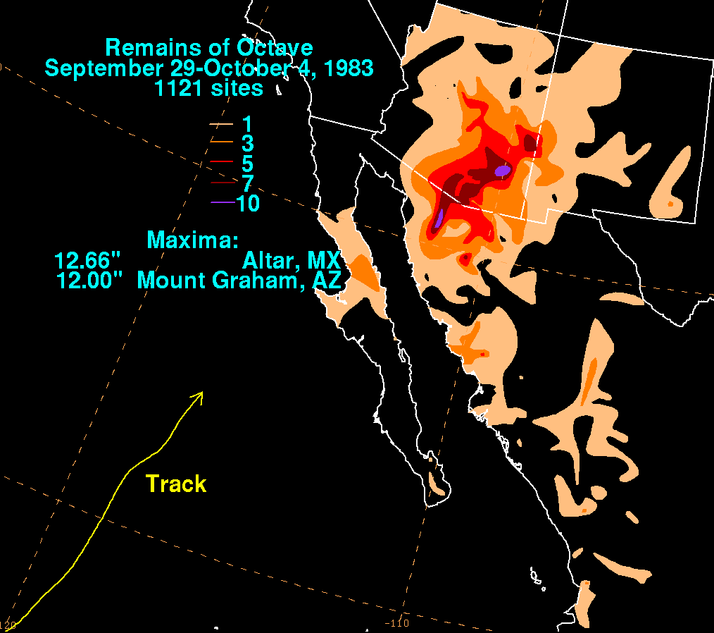
- October 1983: A weather system, including moisture from Tropical Storm Octave, caused torrential rains over a ten-day period. The largest precipitation total occurred in Mount GrahamMount GrahamMount Graham is a mountain in southeastern Arizona in the United States, in the Coronado National Forest. It is the highest mountain in the Pinaleño Mountains. As the name "Mount Graham" is often used by locals to refer to the entire mountain range, the peak itself is frequently referred to as...
, which saw 12 inches (304.8 mm) of rain overall. The downpour caused record floods in the San FranciscoSan Francisco RiverThe San Francisco River is a river in the southwest United States, the largest tributary of the Upper Gila River. The river originates in Arizona and flows into New Mexico before it curves around and enters the Gila down stream from Clifton, Arizona....
, GilaGila RiverThe Gila River is a tributary of the Colorado River, 650 miles long, in the southwestern states of New Mexico and Arizona.-Description:...
, San PedroSan Pedro River (Arizona)San Pedro River is a northward-flowing stream originating about ten miles south of Sierra Vista, Arizona near Cananea, Sonora, Mexico. It is one of only two rivers which flow north from Mexico into the United States. The river flows north through Cochise County, Pima County, Graham County, and...
, and Santa Cruz rivers. The latter breached its banks near Red Rock, and by its intersection with Interstate 8Interstate 8Interstate 8 is an Interstate Highway in the southwestern United States. It runs from the southern edge of Mission Bay at Sunset Cliffs Blvd, in San Diego, California, almost at the Pacific Ocean, to the junction with Interstate 10, just southeast of Casa Grande, Arizona...
, had flooded an area over 8 miles (12.9 km) wide. Fourteen people drowned, 975 were injured, and roughly 10,000 people were left homeless after the flooding ended. The amount of damage from the disaster was put at $370 million (year unknown) USD. Other cities in the state also saw heavy rain, with 9.83 inches (249.7 mm) of precipitation measured at NogalesNogales, ArizonaNogales is a city in Santa Cruz County, Arizona, United States. The population was 21,017 at the 2010 census. According to 2005 Census Bureau estimates, the population of the city is 20,833. The city is the county seat of Santa Cruz County....
, 6.67 inches (169.4 mm) at SaffordSafford, Arizona- History :Safford was founded by Joshua Eaton Bailey, Hiram Kennedy and Edward Tuttle, who came from Gila Bend, in southwestern Arizona. They left Gila Bend in the winter of 1873-74; their work on canals and dams having been destroyed by high water the previous summer...
, 6.4 inches (162.6 mm) at Tucson, 3.93 inches (99.8 mm) at FlagstaffFlagstaff, ArizonaFlagstaff is a city located in northern Arizona, in the southwestern United States. In 2010, the city's population was 65,870. The population of the Metropolitan Statistical Area was at 134,421 in 2010. It is the county seat of Coconino County...
, 2.65 inches (67.3 mm) at Phoenix, and 2.62 inches (66.5 mm) at Prescott.
- September 1984: Hurricane Norbert entered Arizona as a weakening tropical depression. Sustained winds of 20 to 30 mph (32.2 to 48.3 km/h) were recorded in the Tucson area. Modest rainfall occurred throughout south-central to northeast Arizona, with most locations reporting between 1 to 2 in (25.4 to 50.8 mm) of rain. However, Kitt PeakKitt PeakKitt Peak is a mountain in the U.S. state of Arizona. It is the location of the Kitt Peak National Observatory. The radio telescope at the Observatory is one of ten dishes comprising the Very Long Baseline Array ....
reported a 30-hour storm rainfall total of 4.15 inches (105.4 mm). - October 1984: The following month, the remnants of Hurricane Polo caused about 1 inches (25.4 mm) of rain over southern and eastern Arizona, with Nogales reporting 1.93 inches (49 mm) of precipitation.
- October 1989: Flash floodFlash floodA flash flood is a rapid flooding of geomorphic low-lying areas—washes, rivers, dry lakes and basins. It may be caused by heavy rain associated with a storm, hurricane, or tropical storm or meltwater from ice or snow flowing over ice sheets or snowfields...
ing produced by Hurricane RaymondHurricane Raymond (1989)Hurricane Raymond was the strongest tropical cyclone of the 1989 Pacific hurricane season, peaking as a strong Category 4 hurricane on the Saffir-Simpson Hurricane Scale. Forming out of a tropical wave on September 25, the tropical depression slowly tracked northwest before becoming nearly...
caused $1.5 million (1989 USD) in damage in the state. Raymond passed over Arizona as a tropical depression, and produced heavy rainfall on the southeastern portion of the state, with 4.72 inches (119.9 mm) of rain falling in Nogales. About three-quarters of the streets in WillcoxWillcox, ArizonaWillcox is a city in Cochise County, Arizona, United States. According to 2006 Census Bureau estimates, the population of the city is 3,769. Professional wrestler Ted Dibiase lived his formative years in Willcox, as did singer Tanya Tucker.-History:...
were flooded in up to 2 foot (0.6096 m) of water, and sustained winds of 25 mile per hour were reported throughout the southeastern corner of the state.
1990s
Tropical cyclone
A tropical cyclone is a storm system characterized by a large low-pressure center and numerous thunderstorms that produce strong winds and heavy rain. Tropical cyclones strengthen when water evaporated from the ocean is released as the saturated air rises, resulting in condensation of water vapor...
.
- June 1990: The moisture from Boris in 1990 produced 3.28 inches (83.3 mm) of rainfall on the Santa Rita MountainsSanta Rita MountainsThe Santa Rita Mountains, located about 65 km southeast of Tucson, Arizona, extend 42 km from north to south, then trending southeast. They merge again southeastwards into the Patagonia Mountains, trending northwest by southeast...
. - August 1992: Hurricane LesterHurricane Lester (1992)Hurricane Lester was the first Pacific tropical cyclone to enter the United States as a tropical storm since 1967. The twelfth named storm and seventh hurricane of the 1992 Pacific hurricane season, Lester formed on August 20 from a tropical wave southwest of Mexico. The tropical storm moved...
, reached the state as a tropical storm, and caused over 5 inches (127 mm) of precipitation near Phoenix and Tucson. The center of circulation of Lester passed near Tucson on August 24, producing sustained winds of 31 mph (49.9 km/h) at Tucson International AirportTucson International AirportTucson International Airport is a joint civil-military public airport located six miles south of the central business district of Tucson, in Pima County, Arizona, United States, and is the second largest and busiest airport in Arizona, after Sky Harbor International Airport in Phoenix.- Overview...
; the airport also reported gusts of up to 45 mph (72.4 km/h), and a drop in central barometric pressureAtmospheric pressureAtmospheric pressure is the force per unit area exerted into a surface by the weight of air above that surface in the atmosphere of Earth . In most circumstances atmospheric pressure is closely approximated by the hydrostatic pressure caused by the weight of air above the measurement point...
to 999 mbarBar (unit)The bar is a unit of pressure equal to 100 kilopascals, and roughly equal to the atmospheric pressure on Earth at sea level. Other units derived from the bar are the megabar , kilobar , decibar , centibar , and millibar...
(29.52 inHgInch of mercuryInches of mercury, ' is a unit of measurement for pressure. It is still widely used for barometric pressure in weather reports, refrigeration and aviation in the United States, but is seldom used elsewhere....
). Much of the rest of the state reported over 1 inches (25.4 mm) of rain as a result of Lester,. with a peak precipitation measurement of 5.5 inches (139.7 mm) at CascabelCascabel, ArizonaCascabel is a ghost town in Cochise County, Arizona, United States.It is located at , on the banks of the San Pedro River, east of Tucson and about 37 km north-northwest of Benson....
. - August 1993: Hilary's remnants caused flash flooding in Pima County after 3.75 inches (95.3 mm) of rain fell on Green ValleyGreen Valley, ArizonaGreen Valley is a census-designated place in Pima County, Arizona, United States. The population was 17,283 at the 2000 census.-Geography:Green Valley is located at ....
, and 3.5 inches (88.9 mm) of precipitation was recorded at Organ Pipe Cactus National MonumentOrgan Pipe Cactus National MonumentOrgan Pipe Cactus National Monument is a U.S. National Monument and UNESCO biosphere reserve located in extreme southern Arizona which shares a border with the Mexican state of Sonora. The park is the only place in the United States where the Organ Pipe Cactus grows wild...
. - August 1995: Flossie's remnants dumped over 3 inches (76.2 mm) of rain over Tucson; one woman died as she tried to cross a flooded stream, and 11 other motorists were stranded in the city. Damage from the storm in ArizonaArizonaArizona ; is a state located in the southwestern region of the United States. It is also part of the western United States and the mountain west. The capital and largest city is Phoenix...
totaled to $5 million (1995 USD; $ USD). - September 1995: That same year, IsmaelHurricane IsmaelHurricane Ismael was a weak, but deadly Pacific hurricane that killed over one hundred people in northern Mexico in September of the 1995 Pacific hurricane season. It developed from a persistent area of deep convection on September 12, and steadily strengthened as it moved to the north-northwest...
produced most of its damage south of the state, but light rainfall fell over Cochise CountyCochise County, Arizona-2010:Whereas according to the 2010 U.S. Census Bureau:*78.5% White*4.2% Black*1.2% Native American*1.9% Asian*0.3% Native Hawaiian or Pacific Islander*4.0% Two or more races*9.6% Other races*32.4% Hispanic or Latino -2000:...
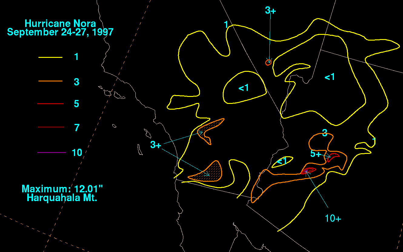
, with the highest reported rainfall being 1.44 inches (36.6 mm). - September 1997: Hurricane NoraHurricane Nora (1997)Hurricane Nora was only the third tropical cyclone on record to reach Arizona as a tropical storm. Nora was the fourteenth named tropical cyclone and seventh hurricane of the 1997 Pacific hurricane season...
, the second storm to reach the state while still retaining tropical characteristics, struck the state in late September and was responsible for the 24-hour rainfall record in the state. Nora produced 11.97 inches (304 mm) of rainfall over the Harquahala MountainsHarquahala MountainsThe Harquahala Mountains are the highest mountain range in southwestern Arizona, USA and are located southwest of the towns of Aguila and Wenden. The name originated from a local Native American people "Aha qua hala" which meant "water there is high up". The range is oriented from northeast to...
in Western Arizona, causing some flash flooding in the area. Near Phoenix, rainfall from the storm caused the Narrows Dam, a small earthen dam, to fail; localized rainfall amounts of up to 3 inches (76.2 mm) occurred throughout the state. Nora also caused 12,000 people to lose electric power in Yuma. Nora is believed to be the strongest tropical storm to strike Arizona, as it produced sustained winds of 50 to 60 mph (80.5 to 96.6 km/h) over Yuma. Nora caused $150–200 million (1997 USDUnited States dollarThe United States dollar , also referred to as the American dollar, is the official currency of the United States of America. It is divided into 100 smaller units called cents or pennies....
) in agricultural losses in Arizona.
- August 1998: The remnants of Tropical Storm Frank produced up to 2 inches (50.8 mm) of rainfall in parts of the state.
- September 1998: The following month, Hurricane IsisHurricane Isis (1998)Hurricane Isis was the deadliest tropical cyclone and only hurricane to make landfall during the 1998 Pacific hurricane season. The ninth tropical storm and sixth hurricane of the season, Isis developed on September 1 from the interaction between a tropical wave and a large surface circulation to...
's remnants dropped more than 2 inches (50.8 mm) of rainfall across southern ArizonaArizonaArizona ; is a state located in the southwestern region of the United States. It is also part of the western United States and the mountain west. The capital and largest city is Phoenix...
, resulting in some flash flood warnings and flooding on roadways. Isis also caused up to 3 inches (76.2 mm) across the Santa CatalinaSanta Catalina MountainsThe Santa Catalina Mountains, commonly referred to as the Catalina Mountains, are located north, and northeast of Tucson, Arizona, United States, on Tucson's north perimeter. The mountain range is the most prominent in the Tucson area, with the highest average elevation...
and Rincon MountainsRincon MountainsThe Rincon Mountains are a significant mountain range east of Tucson, Pima County, Arizona, in the United States. The Rincon Mountains are one of five mountain ranges surrounding the Tucson valley...
that surround Tucson. However, there was no flooding reported in the area, and Tucson International Airport reported only 1.1 inches (27.9 mm) as a result of the storm.
2000s
- October 2000: The remnants of the first system, Tropical Storm Olivia, produced heavy flash floods in spite of Olivia losing tropical characteristics while located 600 miles (965 km) west-southwest of Cabo San Lucas, Baja California SurCabo San LucasCabo San Lucas , commonly called Cabo, is a city at the southern tip of the Baja California peninsula, in the municipality of Los Cabos in the Mexican state of Baja California Sur. As of the 2010 census, the population was 68,463 people...
. However, after being captured by an extratropical cyclone, the remnant low produced widespread heavy rains, with 1.5 to 4 in (38.1 to 101.6 mm) of rain falling over most of southeastern Arizona; HerefordHereford, ArizonaHereford is an unincorporated community in Cochise County along the San Pedro Riparian National Conservation Area in the southern part of the U.S. state of Arizona. It is south of Sierra Vista and is a part of the Sierra Vista-Douglas micropolitan area...
saw 8.64 inches (219.5 mm) of rain. - October 2001: Hurricane JulietteHurricane Juliette (2001)Hurricane Juliette was a long lasting Category 4 hurricane in the 2001 Pacific hurricane season. It caused 12 deaths and $400 million in damage when it hit Baja California in late September.-Meteorological history:...
dissipated in the Gulf of California, and brought only trace amounts of rainfall to the southern half of the state; the largest amount recorded occurred near PatagoniaPatagonia, ArizonaPatagonia is a town in Santa Cruz County, Arizona, United States. As of 2010 Patagonia had a population of 913. Patagonia was formerly a supply center for nearby mines and ranches. Currently, it is a tourist destination, retirement community and arts & crafts center. The Nature Conservancy's...
, where 0.9 inches (22.9 mm) fell. - August 2003: Two years later, the remnants of Hurricane IgnacioHurricane Ignacio (2003)Hurricane Ignacio was the latest-forming first hurricane of a Pacific hurricane season since reliable satellite observation began in 1966. The ninth tropical storm of the 2003 Pacific hurricane season, Ignacio developed out of a tropical wave on August 22 a short distance off the coast of Mexico...
produced rainfall over southern Arizona. About 40 residences in CatalinaCatalina, ArizonaCatalina is a census-designated place in Pima County, Arizona, United States. The population was 7,025 at the 2000 census. Catalina continues to experience increasing population growth, while attempting to maintain its rural character...
were evacuated due to the risk of flash flooding after 2 inches (50.8 mm) of rainfall fell over the Aspen FireAspen FireThe Aspen Fire burned from June 17, 2003 for about a month on Mount Lemmon, part of the Santa Catalina Mountains located in the Coronado National Forest north of Tucson, Arizona, and in the surrounding area...
burn area. - September 2003: That same year, Hurricane MartyHurricane Marty (2003)Hurricane Marty was the deadliest tropical cyclone of the 2003 Pacific hurricane season. Forming on September 18, it became the 13th tropical storm and fourth hurricane of the year...
brought locally heavy rains to extreme southwestern Arizona in September; in spite of this, there were no reports of flooding from the storm. The highest rain total was 2.83 inches (71.9 mm) at Organ Pipe Cactus National MonumentOrgan Pipe Cactus National MonumentOrgan Pipe Cactus National Monument is a U.S. National Monument and UNESCO biosphere reserve located in extreme southern Arizona which shares a border with the Mexican state of Sonora. The park is the only place in the United States where the Organ Pipe Cactus grows wild...
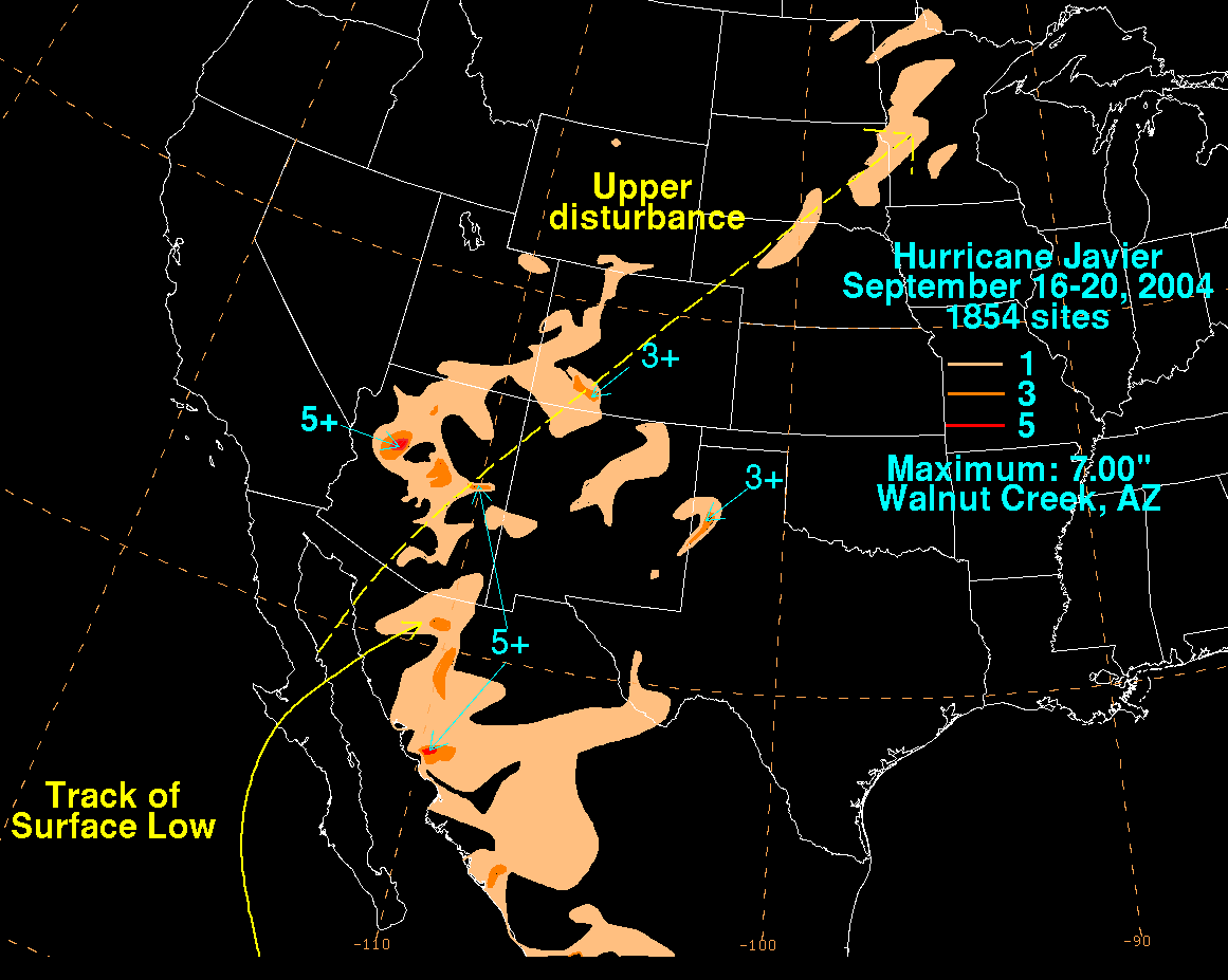
. - September 2004: JavierHurricane Javier (2004)Hurricane Javier was the tenth named storm and the sixth and final hurricane of the 2004 Pacific hurricane season. Javier was also the strongest hurricane of the 2004 season, with 150 mph winds and a central pressure of 930 millibars...
produced heavy rain throughout the state, helping to alleviate a prolonged drought in the Southwestern United StatesSouthwestern United StatesThe Southwestern United States is a region defined in different ways by different sources. Broad definitions include nearly a quarter of the United States, including Arizona, California, Colorado, Nevada, New Mexico, Oklahoma, Texas and Utah...
. The heaviest rainfall occurred at Walnut Creek, which saw a total of 7 inches (177.8 mm) of precipitation during the storm. The Tucson airport saw rainfall of 0.37 inches (9.4 mm), while the University of ArizonaUniversity of ArizonaThe University of Arizona is a land-grant and space-grant public institution of higher education and research located in Tucson, Arizona, United States. The University of Arizona was the first university in the state of Arizona, founded in 1885...
reported 0.89 inches (22.6 mm) of rain. The rain from Javier flooded several roads in the city and, combined with frequent lightningLightningLightning is an atmospheric electrostatic discharge accompanied by thunder, which typically occurs during thunderstorms, and sometimes during volcanic eruptions or dust storms...
, forced the university to delay one of its football games. - July 2006: The remnants of Tropical Storm EmiliaTropical Storm Emilia (2006)Tropical Storm Emilia was a rare tropical cyclone that affected the Baja California peninsula in July 2006. The sixth tropical depression and fifth tropical storm of the 2006 Pacific hurricane season, it developed on July 21 about 400 miles off the coast of Mexico...
produced an influx of tropical moisture over Arizona, triggering a week-long period of disturbed weather in late July. On July 25, a slow-moving severe thunderstorm dropped several inches of rainfall in a few hours, causing the closure of Interstate 19Interstate 19Interstate 19 is an intrastate Interstate Highway located entirely within the state of Arizona. I-19 runs from Nogales, roughly 1,500 feet from the Mexican border, to Tucson, at Interstate 10...
when a wash flooded the roadway with running water 8 inches (203.2 mm) deep. The same storm also produced hail with a diameter of 1.75 inches (44.5 mm) north of Rio RicoRio Rico, ArizonaRio Rico is a census-designated place in Santa Cruz County, Arizona, United States. The population was 18,962 at the 2010 census.-Geography:Rio Rico is located at ....
, and 1 inches (25.4 mm) in Patagonia, and the size of a nickelNickel (United States coin)The nickel is a five-cent coin, representing a unit of currency equaling five hundredths of one United States dollar. A later-produced Canadian nickel five-cent coin was also called by the same name....
in the Tohono O'odham Indian Reservation. The next day, another thunderstorm near ElfridaElfrida, ArizonaElfrida is a small unincorporated community in the southeastern part of the U.S. state of Arizona in Cochise County. Elfrida is located on U.S. Route 191 northwest of Douglas, north of McNeal...
also produced 1 inches (25.4 mm) hail. After one week of widespread rainfall over southeastern Arizona, extensive flooding began to occur. Mount Lemmon saw a 7-day rainfall total of 11.1 inches (281.9 mm); Rillito Creek near the Catalina Mountains conveyed a record flow of 30000 cuft/s. Other streams in the area also saw record flooding, and the Santa Cruz River exceeded flood stage in Marana. The floods caused $4 million (2006 USD) in damage. - September 2006: Hurricane JohnHurricane John (2006)Hurricane John was the eleventh named storm, seventh hurricane, and fifth major hurricane of the 2006 Pacific hurricane season. Hurricane John developed on August 28 from a tropical wave to the south of Mexico. Favorable conditions allowed the storm to intensify quickly, and it attained peak winds...
produced about 1 inches (25.4 mm) of rain over Cochise County. - September 2007: Hurricane HenrietteHurricane Henriette (2007)Hurricane Henriette was the deadliest tropical cyclone of the 2007 Pacific hurricane season. The storm, which caused nine fatalities, formed from an area of disturbed weather on August 30, 2007, and became a tropical storm the next day. The cyclone moved parallel to the Mexican Pacific coast, but...
also produced flooding over Cochise County the following year; one woman died after trying to cross a flooded wash near Sierra VistaSierra Vista, ArizonaSierra Vista is a city in Cochise County, Arizona, United States. According to 2007 Census Bureau estimates, the population of the city is 43,044....
. - July 2008: The remnants from Atlantic hurricane DollyHurricane Dolly (2008)Hurricane Dolly was a tropical cyclone that made landfall in extreme southern Texas in July 2008. Dolly was the fourth tropical cyclone and second hurricane to form during the 2008 Atlantic hurricane season. It was the first U.S. landfalling hurricane of the 2008 season. Dolly developed on July 20...
caused rainfall in the eastern portion of the state, with 1.49 inches (37.8 mm) falling southwest of PortalPortal, ArizonaPortal is an unincorporated community in Cochise County, Arizona, United States. It lies south-southeast of San Simon and at the mouth of Cave Creek Canyon on the east side of the Chiricahua Mountains. Often called the Yosemite of Arizona, the rock walled canyon is composed of fused volcanic tuff...
. - August 2008: Moisture from Tropical Storm JulioTropical Storm Julio (2008)Tropical Storm Julio was a tropical storm that made landfall on the southern tip of Baja California Sur in August 2008. The tenth named storm of the 2008 Pacific hurricane season, it developed from a tropical wave on August 23 off the coast of Mexico. It moved parallel to the coast, reaching peak...
developed thunderstorms across ArizonaArizonaArizona ; is a state located in the southwestern region of the United States. It is also part of the western United States and the mountain west. The capital and largest city is Phoenix...
, including one near ChandlerChandler, Arizona-Demographics:As of the Census of 2010, there were 236,123 people, 86,924 households, and 60,212 families residing in the city. The racial makeup of the city was 73.3% White, 4.8% Black or African American, 1.5% Native American, 8.2% Asian, 0.2% Pacific Islander, 21.9% Hispanic or Latino, and 8.3%...
which produced winds of 75 mph (120 km/h); the storm damaged ten small planes at Chandler Municipal AirportChandler Municipal AirportChandler Municipal Airport is a city-owned public-use airport located three miles southeast of the central business district of Chandler, a city in Maricopa County, Arizona, United States.Although most U.S...
, as well as a hangar. The damages at the airport were estimated at $1 million (2008 USDUnited States dollarThe United States dollar , also referred to as the American dollar, is the official currency of the United States of America. It is divided into 100 smaller units called cents or pennies....
). The storms also dropped heavy rainfall, reaching over 1 inches (25.4 mm) in GilbertGilbert, Arizona-Demographics:As of July 1, 2009, Maricopa Association of Governments, Census 2000. United States Census Bureau. there were 217,521 people, 74,147 housing units, and 3.01 persons per household....
, which caused flooding on Interstate 17Interstate 17Interstate 17 , also known as the Black Canyon Freeway, is an intrastate Interstate Highway located entirely within the state of Arizona, United States. I-17's southern terminus lies within Phoenix, at Interstate 10, and its northern terminus is in Flagstaff, at Interstate 40...
. - September 2009: The remnants of Hurricane JimenaHurricane Jimena (2009)Hurricane Jimena was a Category 4 storm that is tied with Hurricane Norbert as the strongest tropical cyclone to make landfall on western Baja California. Forming from a tropical wave late on August 28, off Mexico's Pacific coast, the system rapidly intensified into a Category 2...
moved over Arizona on September 5. Near WalapaiWalapai, ArizonaWalapai is an unincorporated community in Mohave County, Arizona, United States. Walapai is located along a railroad line northeast of Kingman. Walapai has a post office with ZIP code 86412....
, water, rock, and other debris covered many roads. In addition, several power lines were down at the Bullhead City AirportBullhead City, ArizonaBullhead City is a city located on the Colorado River in Mohave County, Arizona, USA, roughly south of Las Vegas, Nevada, and directly across the Colorado River from Laughlin, Nevada, whose casinos and ancillary services supply much of the employment for Bullhead City...
. Golf ball-sized hail (1.75 inches (44.5 mm) in diameter) fell northwest of Golden ValleyGolden Valley, ArizonaGolden Valley is an unincorporated community and a census-designated place in Mohave County, Arizona, United States. The population was 4,515 at the 2000 census.-Name:...
; a weather spotter's house received $5,000 in damage, with all of its windows broken and with damage to his weather stationWeather stationA weather station is a facility, either on land or sea, with instruments and equipment for observing atmospheric conditions to provide information for weather forecasts and to study the weather and climate. The measurements taken include temperature, barometric pressure, humidity, wind speed, wind...
and radio equipment. In Riviera, southwest of Bullhead CityBullhead City, ArizonaBullhead City is a city located on the Colorado River in Mohave County, Arizona, USA, roughly south of Las Vegas, Nevada, and directly across the Colorado River from Laughlin, Nevada, whose casinos and ancillary services supply much of the employment for Bullhead City...
, seven mobile home trails were blown with many other receiving some damage due to 80 mph (128.7 km/h) wind gusts. In the same area, four people were hurt and total damage was $500,000. North of Mohave ValleyMohave Valley, ArizonaMohave Valley is a census-designated place in Mohave County, Arizona, United States. The population was 13,694 at the 2000 census. It is geographically connected to Needles, California and Bullhead City, Arizona....
, mudslides caused two homes to be destroyed, with 9 others receiving moderate damage, and 16 other receiving minimal damage. Total damage was estimated to be at $600,000. In LaveenLaveen, ArizonaLaveen is a suburban community in Maricopa County, Arizona, United States, situated eight miles southwest of Downtown Phoenix near the confluence of the Gila and Salt rivers. Parts of Laveen constitute an unincorporated area in Maricopa County, while the remainder falls within the city limits of...
, 0.9 inches (22.9 mm) of precipitation fell in a 90-minute period. Heavy rain was recorded in SedonaSedona, ArizonaSedona is a city that straddles the county line between Coconino and Yavapai counties in the northern Verde Valley region of the U.S. state of Arizona...
, thus blocking traffic on State Route 179. in PrescottPrescott, ArizonaPrescott is a city in Yavapai County, Arizona, USA. It was designated "Arizona's Christmas City" by Arizona Governor Rose Mofford in the late 1980s....
, street flooding was reported, closing State Route 69 and the Emerald Trail. In Quartzsite, washes overflowed their banks, causing street flooding, and $30,000 in damage. In Tanca, 1 inches (25.4 mm) of precipitation fell within a 30-minute period, thus causing minor flooding with one road being washed out. Damage from that flood totaled $30,000. YumaYuma, ArizonaYuma is a city in and the county seat of Yuma County, Arizona, United States. It is located in the southwestern corner of the state, and the population of the city was 77,515 at the 2000 census, with a 2008 Census Bureau estimated population of 90,041....
also reported 1.62 inches (41.1 mm) of rain from the cyclone. On the afternoon of September 5, a haystack caught fire due to lighting, and was eventually responsible for an additional $20,000 in damage.
See also
- List of Pacific hurricanes
- List of Pacific hurricane seasons
- List of California hurricanes