
Levee failures in Greater New Orleans, 2005
Encyclopedia
In 29 August 2005 there were over 50 failures of the levee
s and flood walls protecting New Orleans, Louisiana
, and its suburbs following passage of Hurricane Katrina
and landfall in Mississippi. The levee and flood wall failures caused flooding in 80% of New Orleans and all of St. Bernard Parish. Tens of billions of gallons of water spilled into vast areas of New Orleans, flooding over 100,000 homes and businesses. Responsibility for the design and construction of the levee system belongs to the U.S. Army Corps of Engineers; the responsibility of maintenance belongs to the local levee boards. The Corps hands components of the system over to the local levee boards upon completion. When Katrina struck in 2005, the project was between 60-90% complete. Five investigations (three major and two minor) were conducted by civil engineers and other experts, in an attempt to identify the underlying reasons for the failure of the federal flood protection system. All concur that the primary cause of the flooding was inadequate design and construction by the United States Army Corps of Engineers
.
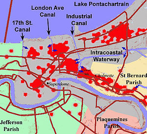
Storm surge caused breaches in 20 places on the Mississippi River-Gulf Outlet Canal
("MR-GO") flooding the entire Saint Bernard Parish and the East Bank of Plaquemines Parish
.
Three major breaches occurred on the Industrial Canal
; one on the northeast side near the junction with Gulf Intracoastal Waterway and two on the southeast side along the Lower Ninth Ward
, between Florida Avenue and Claiborne Avenue. On the east side of New Orleans the 17th Street Canal
levee breached 4 feet (1.2 m) below design specs on the New Orleans side near the Old Hammond Highway Bridge. The London Avenue Canal
in the Gentilly neighborhood breached on both sides; on the west side near Robert E. Lee Boulevard, and on the east, near the Mirabeau Avenue Bridge.
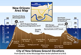
The original residents of Greater New Orleans settled on the high ground along the Mississippi River. Later developments eventually extended to nearby Lake Pontchartrain, built upon fill to bring them above the average lake level. Navigable commercial waterways extended from the lake to downtown. After 1940, the state decided to close those waterways following the completion of a new Industrial Canal for waterborne commerce. Closure of the waterways resulted in a drastic lowering of the water table by the city's drainage system, causing some areas to settle by up to 8 feet (2 m) due to the consolidation of the underlying organic soils. After 1965, the Corps of Engineers built a levee system around a much larger geographic footprint that included previous marshland and swamp. The average elevation of the city is between 1 and 2 foot (0.6096 m) below sea level. There are no residential areas of the city that are currently more than 10 feet (3 m) below sea level.
After the Great Mississippi Flood of 1927
, the Congress
mandated the Corps of Engineers
as the federal agency responsible for design and construction of flood protection projects, to include those in Greater New Orleans. It also affirmed the principle of local participation in federally funded projects but acknowledged that the $292 million already spent by local interests was sufficient to cover local participatory costs. It also required that local interests had to agree to be responsible for maintenance of any proposed levees before the projects would be initiated.
The heavy flooding caused by Hurricane Betsy
in 1965 brought concerns regarding flooding from hurricanes to the forefront. That year, through enactment of the Flood Control Act of 1965
(FCA 1965) Congress authorized the Pontchartrain Hurricane Protection Project. FCA 1965 reiterated the principle of local participation in federally funded projects. The local interests' role was maintenance once the work was complete. Although federally authorized, it was a joint federal, state, and local effort. Almost from the start, the design was impacted by changes due to technical issues, environmental concerns, legal challenges, and local opposition by those opposed to the project. The project was initially estimated to take 13 years, but when Katrina struck in 2005, almost 40 years later, the project was only 60–90% complete with a revised projected completion date of 2015.
On August 29, 2005, flood walls and levees catastrophically failed throughout the metro area. Some – the extent of which is disputed – collapsed well below design thresholds (17th Street and London Canals). Others collapsed after a brief period of overtopping (Industrial Canal) caused "scouring" or erosion of the earthen levee walls – a design flaw. In April 2007, the American Society of Civil Engineers called the flooding of New Orleans "the worst engineering catastrophe in US History."
 Many of the Corps of Engineers-built
levee
failures were reported on Monday, August 29, 2005, at various times throughout the day. There were 28 reported levee failures in the first 24 hours and over 50 were reported in the ensuing days. A breach in the Industrial Canal
, near the St. Bernard
/Orleans parish line, occurred at approximately 9:00 am CDT, the day Katrina hit. Another breach in the Industrial Canal was reported a few minutes later at Tennessee Street, as well as multiple failures in the levee system, and a pump failure in the Lower Ninth Ward
, near Florida Avenue.
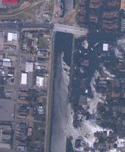
Local fire officials reported a breach at the 17th Street Canal
levee
shortly after 9:00 am CDT. An estimated 66% to 75% of the city was now under water. The Duncan and Bonnabel Pumping Stations were also reported to have suffered roof damage, and were non-functional.
Breaches at St. Bernard and the Lower Ninth Ward were reported at 5:00 pm CDT, as well as a breach at the Hayne Blvd. Pumping Station
, and another breach along the 17th Street Canal levee.
By 8:30 pm CDT, all pumping stations in Jefferson
and Orleans parishes were reported as non-functional.
At 10:00 pm CDT, a breach of the levee on the west bank of the Industrial Canal was reported, bringing 10 feet (3 m) of standing water to the area.
At about midnight, a breach in the London Avenue Canal
levee was reported.
The Orleans Canal
about midway between the 17th Street Canal and the London Avenue Canal, engineered to the same standards, and presumably put under similar stress during the hurricane, survived intact because an incomplete section of floodwall along this canal allowed water to overtop at that point, thus creating a spill way.
The primary mechanisms of failure at the 17th Street Canal, London Avenue Canal and Industrial Canal (east side north) were improper design. The failure mechanism for the Industrial Canal (east side south and west side) was overtopping of levees and floodwalls by the storm surge. The primary mechanism of failure for levees protecting eastern New Orleans was the existence of sand in 10% of places instead of thick Louisiana clay. The primary mechanism of failure for the levees protecting St. Bernard Parish was overtopping due to negligent maintenance of the Mississippi River Gulf Outlet, a navigation channel, by the Army Corps of Engineers.
A June 2006 report by the American Society of Civil Engineers
in peer review panel concluded that the flooding in the Lakeview neighborhood (from the 17th Street Canal) and the Gentilly neighborhood (from the London Avenue Canal) was due to two engineering oversights.
The engineers responsible for the design of the canal levees and the I-walls embedded in them over-estimated the soil strength, meaning that the soil strength used in the design calculations was greater than what actually existed under and near the levee during Hurricane Katrina. They made an unconservative (i.e., erring toward unsafe) interpretations of the data: the soil below the levee was actually weaker than that used in the I-wall design (ASCE: External Review Panel, pg 48). Another critical engineering oversight that led to the failure of the 17th Street Canal involves not taking into account the possibility of a water-filled gap which turned out to be a very important aspect of the failures of the I-walls around New Orleans. “Analysis indicate that, with the presence of a water-filled gap, the factor of safety is about 30 percent lower. Because a factor of safety of 1.3 was used for design, a reduction of 30 percent would reduce the factor of safety to approximately one: a condition of incipient failure.” (ASCE: External Review Panel, pg 51)
Soil borings in the area of the 17th Street Canal
breach showed a layer of peat
starting at about 30 feet (9.1 m) below the surface, and ranging from about 5 feet (1.5 m) to 20 feet (6.1 m) thick. Engineers misjudged the strength of the peat which is from the remains of the swamp on which some areas of New Orleans (near Lake Ponchartrain) in the 20th century were built. The shear strength
of this peat was found to be very low and it had a high water content. According to Robert Bea, a geotechnical engineer from the University of California, Berkeley
, the weak soil made the floodwall very vulnerable to the stresses of a large flood. "At 17th Street, the soil moved laterally, pushing entire wall sections with it. ... As Katrina's storm surge filled the canal, water pressure rose in the soil underneath the wall and in the peat layer. Water moved through the soil underneath the base of the wall. When the rising pressure and moving water overcame the soil's strength, it suddenly shifted, taking surrounding material – and the wall – with it."
The Federal study was initiated in October 2005, by Lt. Gen. Carl Strock, Chief of Engineers
and the Commander of the Corps of Engineers; he established the Interagency Performance Evaluation Task Force (IPET) to "provide credible and objective scientific and engineering answers to fundamental questions about the performance of the hurricane protection and flood damage reduction system in the New Orleans metropolitan area. IPET consisted of independent and recognized experts from the Universities of Maryland
, Florida
, Notre Dame
, and Virginia Polytechnic Institute, the National Oceanic and Atmospheric Administration
, the South Florida Water Management District
, Harris County Flood Control District (Houston, TX), the United States Department of Agriculture
, and the United States Bureau of Reclamation
as well as those from USACE.
IPET's final findings indicated that,
The levee-floodwall designs for the 17th Street and London Avenue Outfall Canals and IHNC were completely inadequate and "designed for failure" according to Dr. Ivor van Heerden, leader of the Team Louisiana investigation. The levees failed catastrophically five feet below design specifications. Levees that were, on-average two feet too low, increased the amount of overtopping, erosion, and subsequent flooding, particularly in eastern New Orleans. A significant number of structures that were subjected to water levels beyond their design limits performed well. Typically, in the case of floodwalls, they represented more conservative design assumptions and, for levees, use of higher quality, less erodible materials.}}
The credibility of the IPET was also challenged in a 42-page letter to the American Society of Engineers submitted by Dr. Ray M. Seed, co-chair of the ILIT study. Dr. Seed described an early intentional plan by the Corps of Engineers to hide their mistakes in the New Orleans flooding after Katrina and to intimidate anyone who tried to intervene. All of this was done with the help and the complicity of some at the ASCE, according to Dr. Seed.
and London Avenue canals, where evidence showed they were breached even though water did not flow over their tops, indicating a design or construction flaw. Eyewitness accounts and other evidence show that levees and flood walls in other parts of the city, such as along the Industrial Canal, were topped by floodwaters first, then breached or eroded. Many New Orleans levee and flood wall failures in the wake of Hurricane Katrina occurred at weak-link junctions where different levee or wall sections joined together, according to a preliminary report released on November 2, 2005, carried out by independent investigators from the University of California, Berkeley
and the American Society of Civil Engineers
(ASCE).
The original design for the steel sheet foundations for the flood walls showed a proposed depth of 10 feet (3 m), and design documents show that calculations were made with the wall base at 12.8 feet (3.9 m). According to a New Orleans engineer, the depth was apparently later increased to 17 feet (5.2 m), and this is what was built. However, a forensic engineering team from the Louisiana State University
, using sonar, showed that at one point near the 17th Street Canal breach, the piling extends just 10 feet (3 m) below sea level, 7 feet (2.1 m) shallower than the Corps of Engineers had maintained. "The Corps keeps saying the piles were 17 feet, but their own drawings show them to be 10 feet, Ivor van Heerden said. "This is the first time anyone has been able to get a firm fix on what's really down there. And, so far, it's just 10 feet. Not nearly deep enough." Other reports confirmed that construction on the London Avenue and Industrial Canal levees was similarly below the stated standard. They also found that homeowners along the 17th Street Canal, near the site of the breach, had been reporting their yards flooding from persistent seepage from the canal for a year prior to Hurricane Katrina. Other studies showed the levee floodwalls on the 17th Street Canal were, "destined to fail,", from bad Corps of Engineers design, saying in part, "that miscalculation was so obvious and fundamental," investigators said, they, "could not fathom how the design team of engineers from the Corps, local firm Eustis Engineering, and the national firm Modjeski and Masters could have missed what is being termed the costliest engineering mistake in American history."
Dr. Robert Bea, chair of an independent levee investigation team, has said that the New Orleans-based design firm Modjeski and Masters could have followed correct procedures in calculating safety factors for the flood walls. He added, however, that design procedures of the Corps may not account for changes in soil strength caused by the changes in water flow and pressure during a hurricane flood. Dr. Bea has also questioned the size of the design safety margins. He said the corps applied a 30% margin over the maximum design load. A doubling of strength would be a more typical margin for highway bridges, dams, off-shore oil platforms and other public structures. There were also indications that substandard concrete may have been used at the 17th Street Canal.
The two sets of November tests conducted by the Corps of Engineers and LSU researchers used non-invasive seismic methods. Both studies understated the length of the piles by about seven feet. By December, seven of the actual piles had been pulled from the ground and measured. The Engineering News Record reported on December 16 that they ranged from 23' 3 1/8" to 23' 7 7/16" long, well within the original design specifications, contradicting the early report of short pilings. The suitability of the original design specifications, however, continues to be contested.
In August 2007, the Corps released an analysis revealing that their floodwalls were so poorly designed that the maximum safe load is only 7 feet (2.1 m) of water, which is half the original 14 feet (4.3 m) design.
, a surge of water estimated at 24 feet (7 m), about 10 feet (3 m) higher than the height of the levees along the city's eastern flank, swept into New Orleans from the Gulf of Mexico
, causing most of the flooding in the city. He said that storm surge from Lake Borgne
travelling up the Intracoastal Waterway
caused the breaches on the Industrial Canal.
Aerial evaluation revealed damage to approximately 90% of some levee systems in the east which should have protected St. Bernard Parish
.
Donald Rumsfeld
announced that an independent panel of experts, under the direction of the National Academy of Sciences
, would convene to evaluate the performance of the New Orleans levee system, and issue a final report in eight months. The panel would study the results provided by the two existing teams of experts that had already examined the levee failures.
On November 9, 2005, The Government Accountability Office
testified before the Senate Committee on Environment and Public Works. The report cited the Flood Control Act of 1965
, which authorized the U.S. Army Corps of Engineers to design and construct a flood protection system to protect south Louisiana
from the strongest storms characteristic of the region.
that, "We have now concluded we had problems with the design of the structure." He also testified that the U.S. Army Corps of Engineers did not know of this mechanism of failure prior to August 29, 2005. The claim of ignorance is refuted, however, by the National Science Foundation
investigators hired by the Army Corps of Engineers, who point to a 1986 study by the corps itself that such separations were possible in the I-wall design.
Nearly two months later, on June 1, 2006, the USACE finalized their report. The final draft of the IPET report states the destructive forces of Katrina were "aided by incomplete protection, lower than authorized structures, and levee sections with erodible materials." The reasons that particular decisions were made concerning incomplete protection, lower structures, and erodible materials were used remains in dispute.
leader Louis Farrakhan
among other public figures claimed the levees were dynamited to divert waters away from wealthy white areas. The conspiracy theory reached a United States House of Representatives
committee investigating Katrina when a New Orleans community activist made the claim. The theory became according to the New Orleans Times Picayune an "urban myth". Reasons for belief in these theories were ascribed to the decision by city officials during The Great Mississippi Flood of 1927
to set off 30 tons of dynamite on the levee at Caernarvon, Louisiana
which eased pressure on levees at New Orleans but flooded St. Bernard Parish, the Ninth Ward taking the brunt of the city's flooding during Hurricane Betsy
, the general disenfranchisement of blacks and lower class people, and the similarity of sound of the levees collapsing to that of a bombing.
Levee
A levee, levée, dike , embankment, floodbank or stopbank is an elongated naturally occurring ridge or artificially constructed fill or wall, which regulates water levels...
s and flood walls protecting New Orleans, Louisiana
New Orleans, Louisiana
New Orleans is a major United States port and the largest city and metropolitan area in the state of Louisiana. The New Orleans metropolitan area has a population of 1,235,650 as of 2009, the 46th largest in the USA. The New Orleans – Metairie – Bogalusa combined statistical area has a population...
, and its suburbs following passage of Hurricane Katrina
Hurricane Katrina
Hurricane Katrina of the 2005 Atlantic hurricane season was a powerful Atlantic hurricane. It is the costliest natural disaster, as well as one of the five deadliest hurricanes, in the history of the United States. Among recorded Atlantic hurricanes, it was the sixth strongest overall...
and landfall in Mississippi. The levee and flood wall failures caused flooding in 80% of New Orleans and all of St. Bernard Parish. Tens of billions of gallons of water spilled into vast areas of New Orleans, flooding over 100,000 homes and businesses. Responsibility for the design and construction of the levee system belongs to the U.S. Army Corps of Engineers; the responsibility of maintenance belongs to the local levee boards. The Corps hands components of the system over to the local levee boards upon completion. When Katrina struck in 2005, the project was between 60-90% complete. Five investigations (three major and two minor) were conducted by civil engineers and other experts, in an attempt to identify the underlying reasons for the failure of the federal flood protection system. All concur that the primary cause of the flooding was inadequate design and construction by the United States Army Corps of Engineers
United States Army Corps of Engineers
The United States Army Corps of Engineers is a federal agency and a major Army command made up of some 38,000 civilian and military personnel, making it the world's largest public engineering, design and construction management agency...
.
Storm surge caused breaches in 20 places on the Mississippi River-Gulf Outlet Canal
Mississippi River-Gulf Outlet Canal
The Mississippi River – Gulf Outlet Canal is a channel constructed by the United States Army Corps of Engineers in the mid-20th century that provided a shorter route between the Gulf of Mexico and New Orleans' inner harbor Industrial Canal via the Intracoastal Waterway...
("MR-GO") flooding the entire Saint Bernard Parish and the East Bank of Plaquemines Parish
Plaquemines Parish, Louisiana
Plaquemines Parish is the parish with the most combined land and water area in the U.S. state of Louisiana. The parish seat is Pointe à la Hache...
.
Three major breaches occurred on the Industrial Canal
Industrial Canal
The Industrial Canal is a 5.5 mile waterway in New Orleans, Louisiana, United States. The waterway's proper name, as used by the U.S. Army Corps of Engineers and on NOAA nautical charts, is Inner Harbor Navigation Canal...
; one on the northeast side near the junction with Gulf Intracoastal Waterway and two on the southeast side along the Lower Ninth Ward
Lower Ninth Ward
Lower Ninth Ward is a neighborhood of the city of New Orleans. As the name implies, it is part of the Ninth Ward of New Orleans. The Lower Ninth Ward is often thought of as the entire area within New Orleans downriver of the Industrial Canal; however, the City Planning Commission divides this...
, between Florida Avenue and Claiborne Avenue. On the east side of New Orleans the 17th Street Canal
17th Street Canal
The 17th Street Canal is a drainage canal in Greater New Orleans, Louisiana, that flows into Lake Pontchartrain. The canal forms a significant portion of the boundary between the city of New Orleans and Metairie, Louisiana...
levee breached 4 feet (1.2 m) below design specs on the New Orleans side near the Old Hammond Highway Bridge. The London Avenue Canal
London Avenue Canal
The London Avenue Canal is a drainage canal in New Orleans, Louisiana, used for pumping rain water into Lake Pontchartrain. The Canal runs through the 7th Ward of New Orleans from the Gentilly area to the Lakefront....
in the Gentilly neighborhood breached on both sides; on the west side near Robert E. Lee Boulevard, and on the east, near the Mirabeau Avenue Bridge.
Background
The original residents of Greater New Orleans settled on the high ground along the Mississippi River. Later developments eventually extended to nearby Lake Pontchartrain, built upon fill to bring them above the average lake level. Navigable commercial waterways extended from the lake to downtown. After 1940, the state decided to close those waterways following the completion of a new Industrial Canal for waterborne commerce. Closure of the waterways resulted in a drastic lowering of the water table by the city's drainage system, causing some areas to settle by up to 8 feet (2 m) due to the consolidation of the underlying organic soils. After 1965, the Corps of Engineers built a levee system around a much larger geographic footprint that included previous marshland and swamp. The average elevation of the city is between 1 and 2 foot (0.6096 m) below sea level. There are no residential areas of the city that are currently more than 10 feet (3 m) below sea level.
After the Great Mississippi Flood of 1927
Great Mississippi Flood of 1927
The Great Mississippi Flood of 1927 was the most destructive river flood in the history of the United States.-Events:The flood began when heavy rains pounded the central basin of the Mississippi in the summer of 1926. By September, the Mississippi's tributaries in Kansas and Iowa were swollen to...
, the Congress
United States Congress
The United States Congress is the bicameral legislature of the federal government of the United States, consisting of the Senate and the House of Representatives. The Congress meets in the United States Capitol in Washington, D.C....
mandated the Corps of Engineers
United States Army Corps of Engineers
The United States Army Corps of Engineers is a federal agency and a major Army command made up of some 38,000 civilian and military personnel, making it the world's largest public engineering, design and construction management agency...
as the federal agency responsible for design and construction of flood protection projects, to include those in Greater New Orleans. It also affirmed the principle of local participation in federally funded projects but acknowledged that the $292 million already spent by local interests was sufficient to cover local participatory costs. It also required that local interests had to agree to be responsible for maintenance of any proposed levees before the projects would be initiated.
The heavy flooding caused by Hurricane Betsy
Hurricane Betsy
Hurricane Betsy was a Category 4 hurricane of the 1965 Atlantic hurricane season which caused enormous damage in the Bahamas, Florida, and Louisiana. Betsy made its most intense landfall near the mouth of the Mississippi River, causing significant flooding of the waters of Lake Pontchartrain into...
in 1965 brought concerns regarding flooding from hurricanes to the forefront. That year, through enactment of the Flood Control Act of 1965
Flood Control Act of 1965
The Flood Control Act of 1965, Title II of , was enacted on October 27, 1965, by the 89th Congress and authorized the United States Army Corps of Engineers to design and construct numerous flood control projects including the Lake Pontchartrain and Vicinity, Louisiana Hurricane Protection Project...
(FCA 1965) Congress authorized the Pontchartrain Hurricane Protection Project. FCA 1965 reiterated the principle of local participation in federally funded projects. The local interests' role was maintenance once the work was complete. Although federally authorized, it was a joint federal, state, and local effort. Almost from the start, the design was impacted by changes due to technical issues, environmental concerns, legal challenges, and local opposition by those opposed to the project. The project was initially estimated to take 13 years, but when Katrina struck in 2005, almost 40 years later, the project was only 60–90% complete with a revised projected completion date of 2015.
On August 29, 2005, flood walls and levees catastrophically failed throughout the metro area. Some – the extent of which is disputed – collapsed well below design thresholds (17th Street and London Canals). Others collapsed after a brief period of overtopping (Industrial Canal) caused "scouring" or erosion of the earthen levee walls – a design flaw. In April 2007, the American Society of Civil Engineers called the flooding of New Orleans "the worst engineering catastrophe in US History."
Levee and floodwall breaches
Flood Control Act of 1965
The Flood Control Act of 1965, Title II of , was enacted on October 27, 1965, by the 89th Congress and authorized the United States Army Corps of Engineers to design and construct numerous flood control projects including the Lake Pontchartrain and Vicinity, Louisiana Hurricane Protection Project...
levee
Levee
A levee, levée, dike , embankment, floodbank or stopbank is an elongated naturally occurring ridge or artificially constructed fill or wall, which regulates water levels...
failures were reported on Monday, August 29, 2005, at various times throughout the day. There were 28 reported levee failures in the first 24 hours and over 50 were reported in the ensuing days. A breach in the Industrial Canal
Industrial Canal
The Industrial Canal is a 5.5 mile waterway in New Orleans, Louisiana, United States. The waterway's proper name, as used by the U.S. Army Corps of Engineers and on NOAA nautical charts, is Inner Harbor Navigation Canal...
, near the St. Bernard
St. Bernard Parish, Louisiana
St. Bernard Parish is a parish located southeast of New Orleans in the U.S. state of Louisiana. The parish seat is Chalmette, the largest city in the parish. As of 2000, its population was 67,229. It has been ranked the fastest-growing county in the United States from 2007 to 2008 by the U.S....
/Orleans parish line, occurred at approximately 9:00 am CDT, the day Katrina hit. Another breach in the Industrial Canal was reported a few minutes later at Tennessee Street, as well as multiple failures in the levee system, and a pump failure in the Lower Ninth Ward
Lower Ninth Ward
Lower Ninth Ward is a neighborhood of the city of New Orleans. As the name implies, it is part of the Ninth Ward of New Orleans. The Lower Ninth Ward is often thought of as the entire area within New Orleans downriver of the Industrial Canal; however, the City Planning Commission divides this...
, near Florida Avenue.
Local fire officials reported a breach at the 17th Street Canal
17th Street Canal
The 17th Street Canal is a drainage canal in Greater New Orleans, Louisiana, that flows into Lake Pontchartrain. The canal forms a significant portion of the boundary between the city of New Orleans and Metairie, Louisiana...
levee
Levee
A levee, levée, dike , embankment, floodbank or stopbank is an elongated naturally occurring ridge or artificially constructed fill or wall, which regulates water levels...
shortly after 9:00 am CDT. An estimated 66% to 75% of the city was now under water. The Duncan and Bonnabel Pumping Stations were also reported to have suffered roof damage, and were non-functional.
Breaches at St. Bernard and the Lower Ninth Ward were reported at 5:00 pm CDT, as well as a breach at the Hayne Blvd. Pumping Station
Pumping station
Pumping stations are facilities including pumps and equipment for pumping fluids from one place to another. They are used for a variety of infrastructure systems, such as the supply of water to canals, the drainage of low-lying land, and the removal of sewage to processing sites.A pumping station...
, and another breach along the 17th Street Canal levee.
By 8:30 pm CDT, all pumping stations in Jefferson
Jefferson Parish, Louisiana
Jefferson Parish is a parish in Louisiana, United States that includes most of the suburbs of New Orleans. The seat of parish government is Gretna....
and Orleans parishes were reported as non-functional.
At 10:00 pm CDT, a breach of the levee on the west bank of the Industrial Canal was reported, bringing 10 feet (3 m) of standing water to the area.
At about midnight, a breach in the London Avenue Canal
London Avenue Canal
The London Avenue Canal is a drainage canal in New Orleans, Louisiana, used for pumping rain water into Lake Pontchartrain. The Canal runs through the 7th Ward of New Orleans from the Gentilly area to the Lakefront....
levee was reported.
The Orleans Canal
Orleans Canal
The Orleans Canal is a drainage canal in New Orleans, Louisiana. The current version of the canal is about 2 km long, running along the up-river side of City Park, through the Lakeview and Lakeshore neighborhood, and into Lake Pontchartrain...
about midway between the 17th Street Canal and the London Avenue Canal, engineered to the same standards, and presumably put under similar stress during the hurricane, survived intact because an incomplete section of floodwall along this canal allowed water to overtop at that point, thus creating a spill way.
Levee investigations
In the five years following Katrina over a dozen investigations were carried out. The only federally ordered study was convened and managed by the Corps of Engineers, the federal agency responsible for the flood protection's performance. A major independent study was conducted by the University of California at Berkeley. A second major study was sponsored by the Louisiana Department of Transportation led by Ivor van Heerden at Louisiana State University. Studies were also done by FEMA, the insurance industry, the National Research Council, the National Institute of Standards and Technology, and the Katrina Consolidated Lawsuit. All studies basically agreed on the engineering mechanisms of failure.The primary mechanisms of failure at the 17th Street Canal, London Avenue Canal and Industrial Canal (east side north) were improper design. The failure mechanism for the Industrial Canal (east side south and west side) was overtopping of levees and floodwalls by the storm surge. The primary mechanism of failure for levees protecting eastern New Orleans was the existence of sand in 10% of places instead of thick Louisiana clay. The primary mechanism of failure for the levees protecting St. Bernard Parish was overtopping due to negligent maintenance of the Mississippi River Gulf Outlet, a navigation channel, by the Army Corps of Engineers.
A June 2006 report by the American Society of Civil Engineers
American Society of Civil Engineers
The American Society of Civil Engineers is a professional body founded in 1852 to represent members of the civil engineering profession worldwide. It is the oldest national engineering society in the United States. ASCE's vision is to have engineers positioned as global leaders who strive toward...
in peer review panel concluded that the flooding in the Lakeview neighborhood (from the 17th Street Canal) and the Gentilly neighborhood (from the London Avenue Canal) was due to two engineering oversights.
The engineers responsible for the design of the canal levees and the I-walls embedded in them over-estimated the soil strength, meaning that the soil strength used in the design calculations was greater than what actually existed under and near the levee during Hurricane Katrina. They made an unconservative (i.e., erring toward unsafe) interpretations of the data: the soil below the levee was actually weaker than that used in the I-wall design (ASCE: External Review Panel, pg 48). Another critical engineering oversight that led to the failure of the 17th Street Canal involves not taking into account the possibility of a water-filled gap which turned out to be a very important aspect of the failures of the I-walls around New Orleans. “Analysis indicate that, with the presence of a water-filled gap, the factor of safety is about 30 percent lower. Because a factor of safety of 1.3 was used for design, a reduction of 30 percent would reduce the factor of safety to approximately one: a condition of incipient failure.” (ASCE: External Review Panel, pg 51)
Soil borings in the area of the 17th Street Canal
17th Street Canal
The 17th Street Canal is a drainage canal in Greater New Orleans, Louisiana, that flows into Lake Pontchartrain. The canal forms a significant portion of the boundary between the city of New Orleans and Metairie, Louisiana...
breach showed a layer of peat
Peat
Peat is an accumulation of partially decayed vegetation matter or histosol. Peat forms in wetland bogs, moors, muskegs, pocosins, mires, and peat swamp forests. Peat is harvested as an important source of fuel in certain parts of the world...
starting at about 30 feet (9.1 m) below the surface, and ranging from about 5 feet (1.5 m) to 20 feet (6.1 m) thick. Engineers misjudged the strength of the peat which is from the remains of the swamp on which some areas of New Orleans (near Lake Ponchartrain) in the 20th century were built. The shear strength
Shear strength (soil)
Shear strength is a term used in soil mechanics to describe the magnitude of the shear stress that a soil can sustain. The shear resistance of soil is a result of friction and interlocking of particles, and possibly cementation or bonding at particle contacts. Due to interlocking, particulate...
of this peat was found to be very low and it had a high water content. According to Robert Bea, a geotechnical engineer from the University of California, Berkeley
University of California, Berkeley
The University of California, Berkeley , is a teaching and research university established in 1868 and located in Berkeley, California, USA...
, the weak soil made the floodwall very vulnerable to the stresses of a large flood. "At 17th Street, the soil moved laterally, pushing entire wall sections with it. ... As Katrina's storm surge filled the canal, water pressure rose in the soil underneath the wall and in the peat layer. Water moved through the soil underneath the base of the wall. When the rising pressure and moving water overcame the soil's strength, it suddenly shifted, taking surrounding material – and the wall – with it."
The Federal study was initiated in October 2005, by Lt. Gen. Carl Strock, Chief of Engineers
Chief of Engineers
The Chief of Engineers commands the US Army Corps of Engineers. As a staff officer at The Pentagon, the Chief advises the Army on engineering matters and serves as the Army's topographer and the proponent for real estate and other related engineering programs....
and the Commander of the Corps of Engineers; he established the Interagency Performance Evaluation Task Force (IPET) to "provide credible and objective scientific and engineering answers to fundamental questions about the performance of the hurricane protection and flood damage reduction system in the New Orleans metropolitan area. IPET consisted of independent and recognized experts from the Universities of Maryland
University of Maryland, College Park
The University of Maryland, College Park is a top-ranked public research university located in the city of College Park in Prince George's County, Maryland, just outside Washington, D.C...
, Florida
University of Florida
The University of Florida is an American public land-grant, sea-grant, and space-grant research university located on a campus in Gainesville, Florida. The university traces its historical origins to 1853, and has operated continuously on its present Gainesville campus since September 1906...
, Notre Dame
University of Notre Dame
The University of Notre Dame du Lac is a Catholic research university located in Notre Dame, an unincorporated community north of the city of South Bend, in St. Joseph County, Indiana, United States...
, and Virginia Polytechnic Institute, the National Oceanic and Atmospheric Administration
National Oceanic and Atmospheric Administration
The National Oceanic and Atmospheric Administration , pronounced , like "noah", is a scientific agency within the United States Department of Commerce focused on the conditions of the oceans and the atmosphere...
, the South Florida Water Management District
South Florida Water Management District
The South Florida Water Management District is a regional governmental agency supervised by the Florida Department of Environmental Protection , and is responsible for water quality, flood control, water supply and restoration of the environment in 16 counties in Central and Southern Florida...
, Harris County Flood Control District (Houston, TX), the United States Department of Agriculture
United States Department of Agriculture
The United States Department of Agriculture is the United States federal executive department responsible for developing and executing U.S. federal government policy on farming, agriculture, and food...
, and the United States Bureau of Reclamation
United States Bureau of Reclamation
The United States Bureau of Reclamation , and formerly the United States Reclamation Service , is an agency under the U.S...
as well as those from USACE.
IPET's final findings indicated that,
The levee-floodwall designs for the 17th Street and London Avenue Outfall Canals and IHNC were completely inadequate and "designed for failure" according to Dr. Ivor van Heerden, leader of the Team Louisiana investigation. The levees failed catastrophically five feet below design specifications. Levees that were, on-average two feet too low, increased the amount of overtopping, erosion, and subsequent flooding, particularly in eastern New Orleans. A significant number of structures that were subjected to water levels beyond their design limits performed well. Typically, in the case of floodwalls, they represented more conservative design assumptions and, for levees, use of higher quality, less erodible materials.}}
Criticism of Federal Investigation (IPET)
The IPET's findings are challenged by Levees.org (a grass roots organization) as lacking credibility since the USACE convened and managed the study and also chose and directly compensated its peer review team. The groups points out that eighty percent of the participants in IPET either worked for the Corps of Engineers or its sister agency Army Research and Development. The top three leaders all were Corps employees.The credibility of the IPET was also challenged in a 42-page letter to the American Society of Engineers submitted by Dr. Ray M. Seed, co-chair of the ILIT study. Dr. Seed described an early intentional plan by the Corps of Engineers to hide their mistakes in the New Orleans flooding after Katrina and to intimidate anyone who tried to intervene. All of this was done with the help and the complicity of some at the ASCE, according to Dr. Seed.
Flood wall design
Investigators focused on the 17th Street17th Street Canal
The 17th Street Canal is a drainage canal in Greater New Orleans, Louisiana, that flows into Lake Pontchartrain. The canal forms a significant portion of the boundary between the city of New Orleans and Metairie, Louisiana...
and London Avenue canals, where evidence showed they were breached even though water did not flow over their tops, indicating a design or construction flaw. Eyewitness accounts and other evidence show that levees and flood walls in other parts of the city, such as along the Industrial Canal, were topped by floodwaters first, then breached or eroded. Many New Orleans levee and flood wall failures in the wake of Hurricane Katrina occurred at weak-link junctions where different levee or wall sections joined together, according to a preliminary report released on November 2, 2005, carried out by independent investigators from the University of California, Berkeley
University of California, Berkeley
The University of California, Berkeley , is a teaching and research university established in 1868 and located in Berkeley, California, USA...
and the American Society of Civil Engineers
American Society of Civil Engineers
The American Society of Civil Engineers is a professional body founded in 1852 to represent members of the civil engineering profession worldwide. It is the oldest national engineering society in the United States. ASCE's vision is to have engineers positioned as global leaders who strive toward...
(ASCE).
The original design for the steel sheet foundations for the flood walls showed a proposed depth of 10 feet (3 m), and design documents show that calculations were made with the wall base at 12.8 feet (3.9 m). According to a New Orleans engineer, the depth was apparently later increased to 17 feet (5.2 m), and this is what was built. However, a forensic engineering team from the Louisiana State University
Louisiana State University
Louisiana State University and Agricultural and Mechanical College, most often referred to as Louisiana State University, or LSU, is a public coeducational university located in Baton Rouge, Louisiana. The University was founded in 1853 in what is now known as Pineville, Louisiana, under the name...
, using sonar, showed that at one point near the 17th Street Canal breach, the piling extends just 10 feet (3 m) below sea level, 7 feet (2.1 m) shallower than the Corps of Engineers had maintained. "The Corps keeps saying the piles were 17 feet, but their own drawings show them to be 10 feet, Ivor van Heerden said. "This is the first time anyone has been able to get a firm fix on what's really down there. And, so far, it's just 10 feet. Not nearly deep enough." Other reports confirmed that construction on the London Avenue and Industrial Canal levees was similarly below the stated standard. They also found that homeowners along the 17th Street Canal, near the site of the breach, had been reporting their yards flooding from persistent seepage from the canal for a year prior to Hurricane Katrina. Other studies showed the levee floodwalls on the 17th Street Canal were, "destined to fail,", from bad Corps of Engineers design, saying in part, "that miscalculation was so obvious and fundamental," investigators said, they, "could not fathom how the design team of engineers from the Corps, local firm Eustis Engineering, and the national firm Modjeski and Masters could have missed what is being termed the costliest engineering mistake in American history."
Dr. Robert Bea, chair of an independent levee investigation team, has said that the New Orleans-based design firm Modjeski and Masters could have followed correct procedures in calculating safety factors for the flood walls. He added, however, that design procedures of the Corps may not account for changes in soil strength caused by the changes in water flow and pressure during a hurricane flood. Dr. Bea has also questioned the size of the design safety margins. He said the corps applied a 30% margin over the maximum design load. A doubling of strength would be a more typical margin for highway bridges, dams, off-shore oil platforms and other public structures. There were also indications that substandard concrete may have been used at the 17th Street Canal.
The two sets of November tests conducted by the Corps of Engineers and LSU researchers used non-invasive seismic methods. Both studies understated the length of the piles by about seven feet. By December, seven of the actual piles had been pulled from the ground and measured. The Engineering News Record reported on December 16 that they ranged from 23' 3 1/8" to 23' 7 7/16" long, well within the original design specifications, contradicting the early report of short pilings. The suitability of the original design specifications, however, continues to be contested.
In August 2007, the Corps released an analysis revealing that their floodwalls were so poorly designed that the maximum safe load is only 7 feet (2.1 m) of water, which is half the original 14 feet (4.3 m) design.
Overtopping of levees in the Eastern New Orleans
According to Professor Raymond Seed of the University of California, BerkeleyUniversity of California, Berkeley
The University of California, Berkeley , is a teaching and research university established in 1868 and located in Berkeley, California, USA...
, a surge of water estimated at 24 feet (7 m), about 10 feet (3 m) higher than the height of the levees along the city's eastern flank, swept into New Orleans from the Gulf of Mexico
Gulf of Mexico
The Gulf of Mexico is a partially landlocked ocean basin largely surrounded by the North American continent and the island of Cuba. It is bounded on the northeast, north and northwest by the Gulf Coast of the United States, on the southwest and south by Mexico, and on the southeast by Cuba. In...
, causing most of the flooding in the city. He said that storm surge from Lake Borgne
Lake Borgne
Lake Borgne is a lagoon in eastern Louisiana of the Gulf of Mexico. Due to coastal erosion, it is no longer actually a lake but rather an arm of the Gulf of Mexico. Its name comes from the French word borgne, which means "one-eyed".-Geography:...
travelling up the Intracoastal Waterway
Intracoastal Waterway
The Intracoastal Waterway is a 3,000-mile waterway along the Atlantic and Gulf coasts of the United States. Some lengths consist of natural inlets, salt-water rivers, bays, and sounds; others are artificial canals...
caused the breaches on the Industrial Canal.
Aerial evaluation revealed damage to approximately 90% of some levee systems in the east which should have protected St. Bernard Parish
St. Bernard Parish, Louisiana
St. Bernard Parish is a parish located southeast of New Orleans in the U.S. state of Louisiana. The parish seat is Chalmette, the largest city in the parish. As of 2000, its population was 67,229. It has been ranked the fastest-growing county in the United States from 2007 to 2008 by the U.S....
.
National Academy of Sciences Investigation
On October 19, 2005, Defense SecretaryUnited States Secretary of Defense
The Secretary of Defense is the head and chief executive officer of the Department of Defense of the United States of America. This position corresponds to what is generally known as a Defense Minister in other countries...
Donald Rumsfeld
Donald Rumsfeld
Donald Henry Rumsfeld is an American politician and businessman. Rumsfeld served as the 13th Secretary of Defense from 1975 to 1977 under President Gerald Ford, and as the 21st Secretary of Defense from 2001 to 2006 under President George W. Bush. He is both the youngest and the oldest person to...
announced that an independent panel of experts, under the direction of the National Academy of Sciences
United States National Academy of Sciences
The National Academy of Sciences is a corporation in the United States whose members serve pro bono as "advisers to the nation on science, engineering, and medicine." As a national academy, new members of the organization are elected annually by current members, based on their distinguished and...
, would convene to evaluate the performance of the New Orleans levee system, and issue a final report in eight months. The panel would study the results provided by the two existing teams of experts that had already examined the levee failures.
Senate Committee hearings
Preliminary investigations and evidence were presented before the U.S. Senate Committee on Homeland Security and Governmental Affairs on November 2, 2005, and generally confirmed the findings of the preliminary investigations.On November 9, 2005, The Government Accountability Office
Government Accountability Office
The Government Accountability Office is the audit, evaluation, and investigative arm of the United States Congress. It is located in the legislative branch of the United States government.-History:...
testified before the Senate Committee on Environment and Public Works. The report cited the Flood Control Act of 1965
Flood Control Act of 1965
The Flood Control Act of 1965, Title II of , was enacted on October 27, 1965, by the 89th Congress and authorized the United States Army Corps of Engineers to design and construct numerous flood control projects including the Lake Pontchartrain and Vicinity, Louisiana Hurricane Protection Project...
, which authorized the U.S. Army Corps of Engineers to design and construct a flood protection system to protect south Louisiana
Louisiana
Louisiana is a state located in the southern region of the United States of America. Its capital is Baton Rouge and largest city is New Orleans. Louisiana is the only state in the U.S. with political subdivisions termed parishes, which are local governments equivalent to counties...
from the strongest storms characteristic of the region.
Corps of Engineers admits problems with design
On April 5, 2006, months after independent investigators had demonstrated that the levee failures were not due to natural forces beyond intended design strength, Lt. Gen. Carl Strock testified before the U.S. Senate Subcommittee on Energy and WaterUnited States Senate Appropriations Subcommittee on Energy and Water Development
The U.S. Senate Appropriations Subcommittee on Energy and Water Development is one of twelve subcommittees of the U.S. Senate Committee on Appropriations.-Jurisdiction:...
that, "We have now concluded we had problems with the design of the structure." He also testified that the U.S. Army Corps of Engineers did not know of this mechanism of failure prior to August 29, 2005. The claim of ignorance is refuted, however, by the National Science Foundation
National Science Foundation
The National Science Foundation is a United States government agency that supports fundamental research and education in all the non-medical fields of science and engineering. Its medical counterpart is the National Institutes of Health...
investigators hired by the Army Corps of Engineers, who point to a 1986 study by the corps itself that such separations were possible in the I-wall design.
Nearly two months later, on June 1, 2006, the USACE finalized their report. The final draft of the IPET report states the destructive forces of Katrina were "aided by incomplete protection, lower than authorized structures, and levee sections with erodible materials." The reasons that particular decisions were made concerning incomplete protection, lower structures, and erodible materials were used remains in dispute.
Conspiracy theories
Nation of IslamNation of Islam
The Nation of Islam is a mainly African-American new religious movement founded in Detroit, Michigan by Wallace D. Fard Muhammad in July 1930 to improve the spiritual, mental, social, and economic condition of African-Americans in the United States of America. The movement teaches black pride and...
leader Louis Farrakhan
Louis Farrakhan
Louis Farrakhan Muhammad, Sr. is the leader of the African-American religious movement the Nation of Islam . He served as the minister of major mosques in Boston and Harlem, and was appointed by the longtime NOI leader, Elijah Muhammad, before his death in 1975, as the National Representative of...
among other public figures claimed the levees were dynamited to divert waters away from wealthy white areas. The conspiracy theory reached a United States House of Representatives
United States House of Representatives
The United States House of Representatives is one of the two Houses of the United States Congress, the bicameral legislature which also includes the Senate.The composition and powers of the House are established in Article One of the Constitution...
committee investigating Katrina when a New Orleans community activist made the claim. The theory became according to the New Orleans Times Picayune an "urban myth". Reasons for belief in these theories were ascribed to the decision by city officials during The Great Mississippi Flood of 1927
Great Mississippi Flood of 1927
The Great Mississippi Flood of 1927 was the most destructive river flood in the history of the United States.-Events:The flood began when heavy rains pounded the central basin of the Mississippi in the summer of 1926. By September, the Mississippi's tributaries in Kansas and Iowa were swollen to...
to set off 30 tons of dynamite on the levee at Caernarvon, Louisiana
Caernarvon, Louisiana
Caernarvon is an unincorporated community in St. Bernard Parish, Louisiana, United States. The name of the community is from a plantation originally located here. The plantation's name is widely believed to be from a similarly named town in Wales.-History:...
which eased pressure on levees at New Orleans but flooded St. Bernard Parish, the Ninth Ward taking the brunt of the city's flooding during Hurricane Betsy
Hurricane Betsy
Hurricane Betsy was a Category 4 hurricane of the 1965 Atlantic hurricane season which caused enormous damage in the Bahamas, Florida, and Louisiana. Betsy made its most intense landfall near the mouth of the Mississippi River, causing significant flooding of the waters of Lake Pontchartrain into...
, the general disenfranchisement of blacks and lower class people, and the similarity of sound of the levees collapsing to that of a bombing.
See also
- Flood Control Act of 1965Flood Control Act of 1965The Flood Control Act of 1965, Title II of , was enacted on October 27, 1965, by the 89th Congress and authorized the United States Army Corps of Engineers to design and construct numerous flood control projects including the Lake Pontchartrain and Vicinity, Louisiana Hurricane Protection Project...
- 17th Street Canal17th Street CanalThe 17th Street Canal is a drainage canal in Greater New Orleans, Louisiana, that flows into Lake Pontchartrain. The canal forms a significant portion of the boundary between the city of New Orleans and Metairie, Louisiana...
- Civil engineering and infrastructure repair in New Orleans after Hurricane KatrinaCivil engineering and infrastructure repair in New Orleans after Hurricane KatrinaThough Hurricane Katrina did not deal the city of New Orleans a direct hit on August 29, 2005, her storm surge precipitated catastrophic failures of the levees and flood walls. The Mississippi River Gulf Outlet breached its levees in approximately 20 places...
- Drainage in New OrleansDrainage in New OrleansDrainage in New Orleans, Louisiana has been a major concern since the founding of the city in the early 18th century, remaining an important factor in the history of New Orleans through today....
- Industrial CanalIndustrial CanalThe Industrial Canal is a 5.5 mile waterway in New Orleans, Louisiana, United States. The waterway's proper name, as used by the U.S. Army Corps of Engineers and on NOAA nautical charts, is Inner Harbor Navigation Canal...
- ING 4727ING 4727ING 4727 was a barge belonging to Ingram Barge Company that became infamous when it went over or through a levee and landed in a residential neighborhood of New Orleans, Louisiana during Hurricane Katrina.-Background and specifications:...
- Old River Control StructureOld River Control StructureThe Old River Control Structure is a floodgate system located in a branch of the Mississippi River in central Louisiana. It regulates the flow of water leaving the Mississippi into the Atchafalaya River, thereby preventing the Mississippi river from changing course. Completed in 1963, the...
- Seabrook Floodgate
- London Avenue CanalLondon Avenue CanalThe London Avenue Canal is a drainage canal in New Orleans, Louisiana, used for pumping rain water into Lake Pontchartrain. The Canal runs through the 7th Ward of New Orleans from the Gentilly area to the Lakefront....
- U.S. Army Corps of Engineers civil works controversies (New Orleans)U.S. Army Corps of Engineers civil works controversies (New Orleans)Through 19 Flood Control Acts since 1917, the United States Congress has authorized the United States Army Corps of Engineers to become involved with design and construction of flood protection and damage reduction system in the Greater New Orleans area and throughout the nation.The Flood Control...
External links
- Levees.Org (non-profit flood protection group in New Orleans)
- Interagency Performance Evaluation Taskforce (IPET) Draft Final Report (1 June 2006) provided by USACE
Note: Site may be slow to load and considered non-secure by IE7Internet ExplorerWindows Internet Explorer is a series of graphical web browsers developed by Microsoft and included as part of the Microsoft Windows line of operating systems, starting in 1995. It was first released as part of the add-on package Plus! for Windows 95 that year... - IPET Draft Final Report (1 June 2006) provided by The Times-Picayune
- YouTube video Eyewitness recreation and plot of explosions seen in the vicinity of the Industrial Canal. Posted by creator/copyright holder of video. Reproduction of video is granted and encouraged.
- Independent Levee Investigation Team (ILIT) Final Report (31 July 2006)
- Hurricane Katrina External Review Panel Report
- Decision-Making Chronology for Hurricane Protection Project