

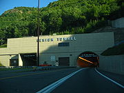
Lehigh Tunnel
Encyclopedia
Pennsylvania Turnpike
The Pennsylvania Turnpike is a toll highway system operated by the Pennsylvania Turnpike Commission in the Commonwealth of Pennsylvania, United States. The three sections of the turnpike system total . The main section extends from Ohio to New Jersey and is long...
Northeast Extension (Interstate 476
Interstate 476
Interstate 476 is a auxiliary Interstate Highway in the U.S. state of Pennsylvania designated between Interstate 95 near Chester and Interstate 81 near Scranton, serving as the primary north–south Interstate corridor through eastern Pennsylvania....
) under the Blue Mountain
Blue Mountain (Pennsylvania)
Blue Mountain is a ridge that forms the eastern edge of the Appalachian mountain range in the U.S. state of Pennsylvania. It cuts across the eastern half of the state from New Jersey to Maryland, providing a distinct boundary between a number of Pennsylvania's geographical and cultural regions...
north from Interstate 78
Interstate 78
Interstate 78 is an Interstate Highway in the Northeast United States, running 144 miles from Interstate 81 northeast of Harrisburg, Pennsylvania, through Allentown, Pennsylvania, and western and northern New Jersey to the Holland Tunnel and Lower Manhattan in New York City.I-78 is a major road...
to the Scranton
Scranton, Pennsylvania
Scranton is a city in the northeastern part of Pennsylvania, United States. It is the county seat of Lackawanna County and the largest principal city in the Scranton/Wilkes-Barre metropolitan area. Scranton had a population of 76,089 in 2010, according to the U.S...
/Wilkes-Barre
Wilkes-Barre, Pennsylvania
Wilkes-Barre is a city in the U.S. state of Pennsylvania, the county seat of Luzerne County. It is at the center of the Wyoming Valley area and is one of the principal cities in the Scranton/Wilkes-Barre metropolitan area, which had a population of 563,631 as of the 2010 Census...
area between mileposts 70.7 to 71.5. The tunnel was called the Lehigh Tunnel to avoid confusion with the existing Blue Mountain Tunnel
Blue Mountain Tunnel
The Blue Mountain Tunnel is one of two tunnels through Blue Mountain in Pennsylvania, located west of Newburg. It is one of seven tunnels completed for the Pennsylvania Turnpike mainline, and at in length, is the shortest of the four still in use today. The Blue Mountain Tunnel is to the east...
on the mainline. The tunnel was "twinned" in 1991 to allow two lanes of traffic in each direction. It has an unusual appearance, as the original (northbound) tunnel is rectangular, as it used the older dig-and-blast technique, while the new tube is oval, having been constructed using the New Austrian Tunnelling method
New Austrian Tunnelling method
The New Austrian Tunnelling method was developed between 1957 and 1965 in Austria. It was given its name in Salzburg in 1962 to distinguish it from old Austrian tunnelling approach. The main contributors to the development of NATM were Ladislaus von Rabcewicz, Leopold Müller and Franz Pacher...
.
From 1980 to 1996, the Northeast Extension was designated as Pennsylvania Route 9, as opposing traffic faced each other in the single tube at 55 mph prior to the opening of the current southbound tube, and therefore did not qualify for Interstate highway status, which was granted five years after the completion of the southbound tube.
The Lehigh Tunnel crosses the border between Lehigh County
Lehigh County, Pennsylvania
-Climate:Most of the county's climate is considered to fall in the humid continental climate zone. Summers are typically hot and muggy, fall and spring are generally mild, and winter is cold. Precipitation is almost uniformly distributed throughout the year....
and Carbon County
Carbon County, Pennsylvania
As of the census of 2000, there were 58,802 people, 23,701 households, and 16,424 families residing in the county. The population density was 154 people per square mile . There were 30,492 housing units at an average density of 80 per square mile...
. It is the only road tunnel crossed by the Appalachian Trail
Appalachian Trail
The Appalachian National Scenic Trail, generally known as the Appalachian Trail or simply the AT, is a marked hiking trail in the eastern United States extending between Springer Mountain in Georgia and Mount Katahdin in Maine. It is approximately long...
.