
Ledges State Park
Encyclopedia
Ledges State Park is a state park
of Iowa
, USA, located approximately 4 miles (6.4 km) south of the city of Boone
. The park contains a sandstone
gorge
carved by Pea's Creek, a tributary of the Des Moines River
. The gorge is 100 feet (30.5 m) deep in places, with concretions jutting from the cliffs.
The lowland areas of the park are regularly flooded by the Des Moines River. In the 1970s, the state created a dam to form Saylorville Lake
on the Des Moines River. This action has resulted in repeated flooding of low-lying areas of the park for decades. A group called The Iowa Citizens to Save Ledges State Park was organized in 1972 in protest of the proposed Saylorville Dam. Its primary objective was to alleviate and/or minimize the harmful effects on Ledges State Park by the Saylorville Lake Project of the U.S. Army Corps of Engineers. There were numerous conservation groups affiliated with the group, including the Ames Reservoir Environmental Study, the Iowa Conservation Commission, and the Iowa Wildlife Society.
The repeated flooding has radically changed the appearance of the lower Ledges—the timbered areas have been greatly reduced, are often covered with silt and, in general, look devastated. This is quite a change from the time when Farwell Brown and his fellow Boy Scouts camped in the Ledges in the 1920s among the lush growth in the lower Ledges. Camping and picnicking in the lower Ledges were popular recreations until the frequent floods made that area of the park less desirable. Many of the picnic areas and picnic houses in the park's flood plain have been decommissioned in the past decade. Annual flooding has made maintenance of the buildings cost prohibitive and seemingly pointless.
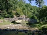
The park includes numerous stone buildings and bridges constructed in the 1930s by the Civilian Conservation Corps
. Also included in the facilities are numerous campsites, picnic tables, and stone shelters, many of which have been destroyed in three decades of regular flooding.
Although extensive flooding to the lowermost portions of Ledges does occur in floods such as in 1993 and 2008, Ledges is still a great place to visit, and even the largest floods on record only submerge a small portion of the park. The canyon road, a winding one lane path traverses through Pea's and Davis creeks at five points and offers views of 50 feet (15.2 m) sandstone walls buttressing 100 feet (30.5 m) bluffs, which were created by glacial melt through sandstone deposited under an inland sea millions of years ago. Evidence of the hard work of the Civilian Conservation Corps is seen in the miles of railroad-tied trails leading up to beautiful vistas overlooking the Des Moines River Valley and the canyon. The Sioux, Fox and Sauk tribes were all once residents of the Ledges State Park area and have numerous burial mounds in the area, and wildlife such as white-tailed deer, raccoon, beaver, woodchuck and many varieties of beautiful and sometimes rare birds such as the pileated woodpecker call the park home.
There is a flood pole located in the lowlands of the park which has recorded the various flood levels over the years.
approximately 13,000 years ago, when meltwater carved quickly down through the rock.
s are located in the park containing mainly basswood, maple
, oak, and hickory
trees. Prairie
and clearings are also located throughout the park. Canoeing and fishing is made possible as the Des Moines River
runs along the west side of the park.
Rustic or modern campsites are available. Most sites are on a first come, first serve basis but certain sites can be reserved.
State park
State parks are parks or other protected areas managed at the federated state level within those nations which use "state" as a political subdivision. State parks are typically established by a state to preserve a location on account of its natural beauty, historic interest, or recreational...
of Iowa
Iowa
Iowa is a state located in the Midwestern United States, an area often referred to as the "American Heartland". It derives its name from the Ioway people, one of the many American Indian tribes that occupied the state at the time of European exploration. Iowa was a part of the French colony of New...
, USA, located approximately 4 miles (6.4 km) south of the city of Boone
Boone, Iowa
Boone is a city in and the county seat of Des Moines Township, Boone County, Iowa, United States. It is the principal city of the 'Boone, Iowa Micropolitan Statistical Area', which encompasses all of Boone County. This micropolitan statistical area, along with the 'Ames, Iowa Metropolitan...
. The park contains a sandstone
Sandstone
Sandstone is a sedimentary rock composed mainly of sand-sized minerals or rock grains.Most sandstone is composed of quartz and/or feldspar because these are the most common minerals in the Earth's crust. Like sand, sandstone may be any colour, but the most common colours are tan, brown, yellow,...
gorge
Canyon
A canyon or gorge is a deep ravine between cliffs often carved from the landscape by a river. Rivers have a natural tendency to reach a baseline elevation, which is the same elevation as the body of water it will eventually drain into. This forms a canyon. Most canyons were formed by a process of...
carved by Pea's Creek, a tributary of the Des Moines River
Des Moines River
The Des Moines River is a tributary river of the Mississippi River, approximately long to its farther headwaters, in the upper Midwestern United States...
. The gorge is 100 feet (30.5 m) deep in places, with concretions jutting from the cliffs.
Background
The area was designated one of the first of Iowa's state parks in 1924, and is today one of its most visited parks.The lowland areas of the park are regularly flooded by the Des Moines River. In the 1970s, the state created a dam to form Saylorville Lake
Saylorville Lake
Saylorville Lake is a reservoir on the Des Moines River in Iowa. It is located upstream from the city of Des Moines, and from the mouth of the Des Moines River at the Mississippi River...
on the Des Moines River. This action has resulted in repeated flooding of low-lying areas of the park for decades. A group called The Iowa Citizens to Save Ledges State Park was organized in 1972 in protest of the proposed Saylorville Dam. Its primary objective was to alleviate and/or minimize the harmful effects on Ledges State Park by the Saylorville Lake Project of the U.S. Army Corps of Engineers. There were numerous conservation groups affiliated with the group, including the Ames Reservoir Environmental Study, the Iowa Conservation Commission, and the Iowa Wildlife Society.
The repeated flooding has radically changed the appearance of the lower Ledges—the timbered areas have been greatly reduced, are often covered with silt and, in general, look devastated. This is quite a change from the time when Farwell Brown and his fellow Boy Scouts camped in the Ledges in the 1920s among the lush growth in the lower Ledges. Camping and picnicking in the lower Ledges were popular recreations until the frequent floods made that area of the park less desirable. Many of the picnic areas and picnic houses in the park's flood plain have been decommissioned in the past decade. Annual flooding has made maintenance of the buildings cost prohibitive and seemingly pointless.
The park includes numerous stone buildings and bridges constructed in the 1930s by the Civilian Conservation Corps
Civilian Conservation Corps
The Civilian Conservation Corps was a public work relief program that operated from 1933 to 1942 in the United States for unemployed, unmarried men from relief families, ages 18–25. A part of the New Deal of President Franklin D...
. Also included in the facilities are numerous campsites, picnic tables, and stone shelters, many of which have been destroyed in three decades of regular flooding.
Although extensive flooding to the lowermost portions of Ledges does occur in floods such as in 1993 and 2008, Ledges is still a great place to visit, and even the largest floods on record only submerge a small portion of the park. The canyon road, a winding one lane path traverses through Pea's and Davis creeks at five points and offers views of 50 feet (15.2 m) sandstone walls buttressing 100 feet (30.5 m) bluffs, which were created by glacial melt through sandstone deposited under an inland sea millions of years ago. Evidence of the hard work of the Civilian Conservation Corps is seen in the miles of railroad-tied trails leading up to beautiful vistas overlooking the Des Moines River Valley and the canyon. The Sioux, Fox and Sauk tribes were all once residents of the Ledges State Park area and have numerous burial mounds in the area, and wildlife such as white-tailed deer, raccoon, beaver, woodchuck and many varieties of beautiful and sometimes rare birds such as the pileated woodpecker call the park home.
There is a flood pole located in the lowlands of the park which has recorded the various flood levels over the years.
Geology
The sandstone of the cliffs was the remnant of the prehistoric sea that covered the Midwest approximately 300 million years ago. The cliffs themselves are the result of recent glaciation during the last ice ageIce age
An ice age or, more precisely, glacial age, is a generic geological period of long-term reduction in the temperature of the Earth's surface and atmosphere, resulting in the presence or expansion of continental ice sheets, polar ice sheets and alpine glaciers...
approximately 13,000 years ago, when meltwater carved quickly down through the rock.
Recreation
Many hiking trails are located throughout the Ledges. WoodlandWoodland
Ecologically, a woodland is a low-density forest forming open habitats with plenty of sunlight and limited shade. Woodlands may support an understory of shrubs and herbaceous plants including grasses. Woodland may form a transition to shrubland under drier conditions or during early stages of...
s are located in the park containing mainly basswood, maple
Maple
Acer is a genus of trees or shrubs commonly known as maple.Maples are variously classified in a family of their own, the Aceraceae, or together with the Hippocastanaceae included in the family Sapindaceae. Modern classifications, including the Angiosperm Phylogeny Group system, favour inclusion in...
, oak, and hickory
Hickory
Trees in the genus Carya are commonly known as hickory, derived from the Powhatan language of Virginia. The genus includes 17–19 species of deciduous trees with pinnately compound leaves and big nuts...
trees. Prairie
Prairie
Prairies are considered part of the temperate grasslands, savannas, and shrublands biome by ecologists, based on similar temperate climates, moderate rainfall, and grasses, herbs, and shrubs, rather than trees, as the dominant vegetation type...
and clearings are also located throughout the park. Canoeing and fishing is made possible as the Des Moines River
Des Moines River
The Des Moines River is a tributary river of the Mississippi River, approximately long to its farther headwaters, in the upper Midwestern United States...
runs along the west side of the park.
Rustic or modern campsites are available. Most sites are on a first come, first serve basis but certain sites can be reserved.