

Lao Cai Province
Encyclopedia
Lào Cai is a province
of northeastern
in the mountainous region of Vietnam
, bordering the province of Yunnan
in the China
. The province covers an area of 6383.9 square kilometres and as of 2008 it had a population of 602,300 people.
Lao Cai
and Sa Pa
are two important cities within the province at the border with China; the former is well known as key trading post and the latter is hill station famous for tourism, in northeastern
Vietnam
. Lao Cai is also the capital of Lào Cai Province and shares border with the city of Hekou
, in the Yunnan
province of Southwest China
. This border town was closed after the 1979 war with China, since reopened in 1993, has become a major tourist centre between Hanoi, Sapa and Kunming (China). Sapa
is notable as a hill resort, a market town for timber and sex trade and known as the "queen of mountains"
Lào Cai has many historical sites, natural caves and produces agricultural specialties such as Bắc Hà plums.
In a 1929 survey conducted in the area, the vegetation (flora) and fauna (mammals) recorded by the French biologist Delacour who accompanied Theodore Roosevelt
were unique to the region in North Vietnam.
The origin of the province's name is unclear and there are several explanations. The area in the ward of Cốc Lếu was the site of an old commercial district that developed into a market town. Because of this it was called Lão Nhai (老街, literally Phố Cũ, Old Town). After this a new market town was developed and named Tân Nhai (新街, today Phố Mới, New Town). "Lão" and "Lạo" is the name of an ethnic group, so "Lão Nhai" was seen to mean "town of the Lão/Lạo". The word Lào Cai is sourced to "Lao Kaù" which appeared in 1872 (the name of a boat of Jean Dupuis, who led a naval expedition up the Red River. According to Professor Đào Duy Anh, it derives from the word "Lão Nhai". While making maps, the French wrote it as "Lào Kay" and this word was used by them in documents. When reading, the Vietnamese pronounced it Lào Cai and this has persisted since.
 Lào Cai Province is located in the north of the country and has an area of 6383.9 square kilometre. It borders the provinces of Hà Giang
, Yên Bái, Sơn La, and Lai Châu, as well as the province of Yunnan
in the People's Republic of China
.
There are ten major soil groups under 30 categories in the province, under 10 land groups. The land groups are: The Alluvial group (1.47% of the land area) along the Red River is good for growing food crops and trees; the Oxisol type which occupies 40 % of land area has generally reddish brown soil, below altitude of 900 metres (2,952.8 ft), is a fertile land suitable for the annual and commercial crops; Team Red Yellow soil humus covers 30 % land area in the Sa Pa, Muong Khuong, Bac Ha, Bat Xat districts of the province suitable for medicinal plants, fruit trees and vegetables; humus soil on the mountain occupies 11.42% of the land area mostly in Sa Pa district which has rich canopy of mixed forest; and the Oxisol color altered by rice in 2% of land area are formed into a landscape of terraced fields, as seen in Bac Ha and Sa Pa districts.
Climate
As the province is mostly mountainous, it experiences a dry cold climate from October to March, while the tropical monsoon is rainy season which lasts from April to September. The annual average temperature is 23 °C (73.4 °F). The temperature generally ranges between18 °C (64.4 °F) and 28 °C (82.4 °F) in the mountainous region, with the lowland areas showing a temperature variation of between 20 °C (68 °F) and 22 °C (71.6 °F). In Sapa town however, the temperature drops to less than 0 °C (32 °F) with snowing conditions. Fog and frost are a common phenomenon in the province.
Water resources
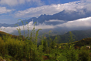
Lào Cai is a mountainous region. In the northwest of the province is Phan Xi Păng
(also called Fansipan; elevation 3143 metres (10,311.7 ft), snow covered during winter season), Vietnam's highest mountain. It is located in the Hoàng Liên Sơn and the Hoàng Liên National Park
. The Sa Pa Mountains form the western part of the province. While the province is drained by over 100 rivers, the main river that bisects the province is the Red River
, (Song Hong), the most significant river of northern Vietnam, which flows out of China towards the capital Hanoi
. It flows through the province over a length of 130 kilometres (80.8 mi). Other rivers of significance are the Chay and Nam Ti Rivers. Much of the province is heavily forested.
Ground water resources have been estimated reserves as 4448 million cubic metres out of which good quality water is estimated as 30 million cubic metres. In addition, there are four mineral water sources.
Mineral resources
The province has rich mineral resources, 30 types have been identified with good reserves. The major valuable mineral reserves are: Copper (53 million tons), molybdenum (15 million tons), apatite
and iron (2.5 billion tons). There are 150 mines in the province exploiting various minerals.
In the Fansipan mountain
ranges, vegetation varies with altitude, with elevation above 1500 metres (4,921.3 ft) retaining the forests. In the elevation range of 2500–2800 m (8,202.1–9,186.4 ft), which is the mist area, “Elfin forest
” is the dominant forest vegetation of “gnarled trees (Tsuga yunanaris
)” of less than 8 metres (26.2 ft) height covered with moss
. Above 2800 metres (9,186.4 ft) elevation, the mountain range has undersized vegetation with lots of bamboo
s and rhododendron
s.
The Hoang Lien National Park has only 12 square kilometre of forest left as a result of anthropogenic pressure over centuries. Grass, bushes and small trees are seen on the land which are devoid of forests, and large areas are used for cultivation; ginger
plantation, as a cash crop is wide spread.
According to a 1929 survey conducted in the area, the fauna (mammals) recorded by the French biologist Delacour who accompanied Theodore Roosevelt were: the clouded leopard
(Neofelis nebuiosa), leopard
(Panthera pardus), tiger (panthera tigris), binturong
(Arctictus binturong) and black gibbon (Hylobates concolor), the stump-tailed macaque
(Macaca arctoides), and Asiatic black bear
(Selenarctos thibetanus). In Sa Pa
forests, 150 species of birds were recorded such as the Red-vented Barbet
( Megalaima lagrandieri), Collared Finchbill
(Spizixo semitoroues), White-throated Laughingthrush
(Garrulax albogularis) and the Chestnut Bulbul
(Hypsipetes castanotus); all species are considered exclusive to North Vietnam
.
 Lao Cai has been known since ancient times as a historic trading post. Here, the Chinese, the Vietnamese and the ethnic minorities of the region fought to gain control of the region. In 1463, the Viet Kings established Lao Cai as the capital of their northern most region, then named as Hung Hoa. It came under French colonial rule in 1889 and was their administrative town, and also served as a military garrison. In the early 19th century the first railway line was built from Hanoi to this region. It took 7 years to complete but at the cost of 25,000 lives of Vietnamese conscripted labour.
In late 1978, the Vietnamese invaded Cambodia
. In retaliation, the Chinese, as allies of Cambodia, countered and invaded North Vietnam with the sole aim of “teaching the Vietnamese a lesson”. The attack was launched by 60,000 strong Chinese Army from several fronts. They occupied territory from Paso (previously known as Phon Tho) in the Northwest to Cao Bang and Lang Son in the Northeast. The Chinese were ill prepared for such a massive campaign, and within two weeks their attack crumbled, they lost 20,000 troops and withdrew from Vietnam but still boasting that they had won the battle. The Vietnamese had won a decisive battle on all fronts. It has been inferred that the border town, 295 km from Hanoi, with good rail, road and river traffic provided the impetus to the invaders to threaten Hanoi and the Red River Valley and that the "attacks here were intended as distractions to prevent their Vietnamese defenders from moving to reinforce the defense of Lao Cai."
After the province was invaded by the Chinese in 1979 from its border town Lao Cai, the border with China was closed for several years. In this war, the city of Lao Cai was destroyed by the Chinese. Remnants of the war in the form of land mines are reported to pose threat to people along the border with China.
The Lao Cai town at the border town on the bank of Red River as the provincial capital has now prospered in view of large trade with China and is a booming city with a community of many rich millionaires. Since 2006, Lao Cai has the status of a city, is the largest town in the region and strategically very important. An airport is planned to be built by 2020.
and 8 rural districts (huyện):Bắc Hà District, Bảo Thắng District, Bảo Yên District, Bát Xát District, Mường Khương District, Sa Pa District
, Si Ma Cai District and Văn Bàn District. There are eighth towns under districts. The districts are divided into 144 communes.
 Lào Cai is currently one of the two poorest provinces in the country along with Lai Chau, with more than 70% of the population living under the poverty line. Traditional economic activities such as agriculture
and forestry
remain important, but the province has also been attempting to develop foreign investment in the area. Cross-border trade with China is also a growing source of income, as is tourism centred on trekking up the peak of Fansipan, Vietnam's highest mountain. Ecotourism is gaining ground. Agriculture and forestry constitute 78.07% of economic activity; fishing and aquaculture 0.04%, mining 1.62%; manufacturing 2.37%, power and water 0.22%, construction 3.29%, repairmen 3.48%; hospitality 0.90%, communications 1.31%; finance 0.21%, science and technology 0.05%;, education and research 3.57%; health and social work 0.69%; cultural activities 0.24% and several other small sectors.
As against the national figure of 7592 cooperatives, there are 19 cooperatives in the province, out of which 17 are agricultural cooperatives and one is a fisheries cooperative. There are only 253 farms as compared to the national number of 120,699. The output value of agriculture produce at constant 1994 prices in the province was 663 billion đồngs against the national value of 156681.9 billion dongs.
In 2008, the province produced 199,800 tonnes of cereals compared to the national production of 43.68 million tonnes. The per capita production of cereals in the province was 491.4 kilograms (1,083.4 lb) as against the national figure of 331.7 kilograms (731.3 lb) in 2008.
In 2007, the industrial output of the province was a meagre 1916.2 bill. dongs against the national output of 1.47 million billion dongs.
Lào Cai has 150 mines or mining locations of 30 different categories, some of which are the largest of their kind in the country. These include the apatite
mine at Cam Đường with 2.5 billion tonnes, the iron mine at Quý Xa with 124 million tons, the copper mine at Sin Quyền with 53 million tons, the molybdenum mine at Ô Quy Hồ with 15,400 tons.
In recent years the government of Vietnam has encouraged reforestation in the province, because of the importance of wood for fuel and development and for environmental reasons. Tree planting has been ordered particularly in Sa Pa District.
 With more than 20 ethnic groups, Lào Cai is a melting pot of cultures and history. Ethnic Vietnamese are the majority, especially since 1960 when the North Vietnamese government followed a policy of settling communist party cadres from lowland areas in upland areas, then predominantly occupied by tribes. According to the General Statistics Office of the Government of Vietnam, the population of Lao Cai province, as of 2008, was 602,300 with a density of 94 persons per square km over a total land area of 6383.9 square kilometre of the province. The male population during this period was 303300 with females accounting for 299,000. The urban population was 125,900 against an urban population of 476,400 (about 25% of the rural population).
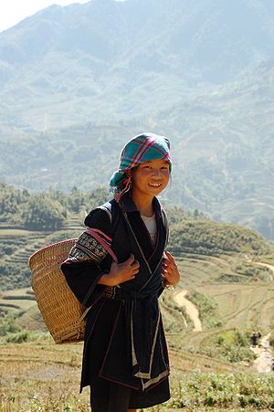
The province has 25 Vietnam's ethnic minority groups accounting for 64.09 % of its population. The distribution of the ethnic minorities comprises: Kinh - 35.9%, Hmong
- 22.21%, Tay - 15.84%, Dao -14.05%, Giay - 4.7%, Nung 4.4% and the others belong to Phu La, San Chay, Ha Nhi, and the La Chi groups.
is located within the province and was upgraded from a nature reserve in 2006. It covers an area of 24.66 square kilometres (30 km2 is also mentioned in some references) and contains the peak of Fan Si Pan, which, at 3143 metres (10,311.7 ft), is the highest peak in Vietnam. The park contains heavy forests and a rich biodiversity, although because of agricultural production of ginger and other land uses, today only about 12 kilometres (7.5 mi) of the park is forested. 1884 migrating raptors have been recorded in the national park, which is stated to be a rarity in terms of numbers and the species varieties. The area was surveyed by French biologist Delacour in 1929 who had accompanied Theodore Roosevelt
to an expedition in southeast Asia. He collected 48 mammal species for the Chicago Natural History Museum although most were shot. Sediments in the park date back to the Mesozoic era, whilst the granite is a Palaeocene intrusion. The northeastern boundary of the national park is made with a rugged boundary of marble
and metamorphosed calcium carbonate
.
province in China. Within the province, road links exist to Sapa and Bac Ha
. The Haiphong
railway to Yunnan
is of strategic importance. There are four national highways totaling to a length of 400 km, provincial roads of about 300 km length and 1000 km of village roads.
The Hanoi-Lao Cai railway is 296 kilometres (183.9 mi), of which 62 kilometres (38.5 mi) is in the province, and links to Chinese railways at the border. It can carry 1 billion tonnes of freight per year and thousands per day. Plans for a high-speed rail link between Hanoi and Lao Cai has been investigated by the Ministry of Transport and the Asian Development Bank
. This is expected to create a high-speed rail corridor from Kunming
– Lào Cai – Hanoi – Haiphong.
Red River flowing through the province provides water transport facilities though its transportation capacity is limited.
A popular motorbiking route among tourists that covers the mountainous region of the province known as the "Tonkinese Alps", is to start from the White Thai
villages, Son La
, historic site of Dien Bien Phu
and terminating at Sa Pa.
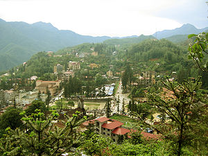
Sa Pa
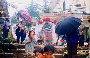
is one of 21 national tourism areas in Vietnam. Sa Pa is at an altitude of 1200–1800 m (0.745647283979768–1.1 mi), has a mild climate throughout the year, lush, forested and mountainous scenery, waterfalls and is a hub of cultural activities of various ethnic minorities in the region, such as the Hmong
and Dao
people used to gather during the weekly market to "attend an ephemeral "Love Market" where young men and women chose partners to marry. Sa Pa is now associated with sex tourism
, mainly Chinese and Vietnamese along with the border town of Lao Cai. It is 38 km away from the border town of Lao Cai. Visit to Sapa town is said to be more popular among visitors from Western Countries in view of its attraction of ethnic tribals. In fact, the French had established a Travel Bureau, as early as 1917, and the town was popular among the "French colonist" all through their rule as a hill resort. However, Sa Pa has gone through several rounds of destruction between 1947 and 1953, and again in 1979 due to war with French and Chinese. It has been partly restored and has gradually become a tourist hub since the region was opened to tourism in 1993. A good time to visit Sa Pa would be when Rice Field in different green shades are being harvested in the fall season (September to November). The colours of the rice fields indicate the time for harvesting various plots. The women of the ethnic minority tribes who harvest the crops on the fields further accentuate the different green shades of the fields with their eye catching red and indigo coloured dresses.
Lào Cai has many historical sites, natural caves and produces agricultural specialties such as Bắc Hà plums.
Provinces of Vietnam
Vietnam is divided into 58 provinces and five centrally governed cities existing at the same level as provinces ....
of northeastern
Dong Bac
The Northeast is the region at the north of the Red River Delta, Vietnam. Northeast called to distinguish them from the Northwest, but it's actually in the north and northeast of Hanoi, wider than Việt Bắc. The northeast is one of three sub-regions of northern Vietnam...
in the mountainous region of Vietnam
Vietnam
Vietnam – sometimes spelled Viet Nam , officially the Socialist Republic of Vietnam – is the easternmost country on the Indochina Peninsula in Southeast Asia. It is bordered by China to the north, Laos to the northwest, Cambodia to the southwest, and the South China Sea –...
, bordering the province of Yunnan
Yunnan
Yunnan is a province of the People's Republic of China, located in the far southwest of the country spanning approximately and with a population of 45.7 million . The capital of the province is Kunming. The province borders Burma, Laos, and Vietnam.Yunnan is situated in a mountainous area, with...
in the China
People's Republic of China
China , officially the People's Republic of China , is the most populous country in the world, with over 1.3 billion citizens. Located in East Asia, the country covers approximately 9.6 million square kilometres...
. The province covers an area of 6383.9 square kilometres and as of 2008 it had a population of 602,300 people.
Lao Cai
Lao Cai
Lào Cai is a city in northeastern Vietnam. It is the capital of Lao Cai province. The city borders the city of Hekou, in the Yunnan province of Southwest China. It lies at the junction of the Red River and the Nam Ti River approximately 160 miles northwest of Hanoi...
and Sa Pa
Sa Pa
Sa Pa , or Sapa, is a frontier town and capital of Sa Pa District in the Lao Cai province in northwest Vietnam. It is one of the main market towns in the area, where several ethnic minority groups such as Hmong, Dao , Giay, Pho Lu, and Tay live....
are two important cities within the province at the border with China; the former is well known as key trading post and the latter is hill station famous for tourism, in northeastern
Dong Bac
The Northeast is the region at the north of the Red River Delta, Vietnam. Northeast called to distinguish them from the Northwest, but it's actually in the north and northeast of Hanoi, wider than Việt Bắc. The northeast is one of three sub-regions of northern Vietnam...
Vietnam
Vietnam
Vietnam – sometimes spelled Viet Nam , officially the Socialist Republic of Vietnam – is the easternmost country on the Indochina Peninsula in Southeast Asia. It is bordered by China to the north, Laos to the northwest, Cambodia to the southwest, and the South China Sea –...
. Lao Cai is also the capital of Lào Cai Province and shares border with the city of Hekou
Hekou
Hekou may refer to the following in China:*Hekou District , Dongying, Shandong*Hekou Group, geological formation in Gansu*Hekou Yao Autonomous County , of Honghe Hani and Yi Autonomous Prefecture, Yunnan...
, in the Yunnan
Yunnan
Yunnan is a province of the People's Republic of China, located in the far southwest of the country spanning approximately and with a population of 45.7 million . The capital of the province is Kunming. The province borders Burma, Laos, and Vietnam.Yunnan is situated in a mountainous area, with...
province of Southwest China
Southwest China
Southwest China is a region of the People's Republic of China defined by governmental bureaus that includes the municipality of Chongqing, the provinces of Sichuan, Yunnan and Guizhou, and the Tibet Autonomous Region.-Provinces:-Municipalities:...
. This border town was closed after the 1979 war with China, since reopened in 1993, has become a major tourist centre between Hanoi, Sapa and Kunming (China). Sapa
Sa Pa
Sa Pa , or Sapa, is a frontier town and capital of Sa Pa District in the Lao Cai province in northwest Vietnam. It is one of the main market towns in the area, where several ethnic minority groups such as Hmong, Dao , Giay, Pho Lu, and Tay live....
is notable as a hill resort, a market town for timber and sex trade and known as the "queen of mountains"
Lào Cai has many historical sites, natural caves and produces agricultural specialties such as Bắc Hà plums.
In a 1929 survey conducted in the area, the vegetation (flora) and fauna (mammals) recorded by the French biologist Delacour who accompanied Theodore Roosevelt
Theodore Roosevelt
Theodore "Teddy" Roosevelt was the 26th President of the United States . He is noted for his exuberant personality, range of interests and achievements, and his leadership of the Progressive Movement, as well as his "cowboy" persona and robust masculinity...
were unique to the region in North Vietnam.
Etymology
The noun "Lào Kay" has been used by the French since the colonial era in their writing, pronounced "Lao Cai" to Vietnamese. The latter became official usage and spelling after November 1950.The origin of the province's name is unclear and there are several explanations. The area in the ward of Cốc Lếu was the site of an old commercial district that developed into a market town. Because of this it was called Lão Nhai (老街, literally Phố Cũ, Old Town). After this a new market town was developed and named Tân Nhai (新街, today Phố Mới, New Town). "Lão" and "Lạo" is the name of an ethnic group, so "Lão Nhai" was seen to mean "town of the Lão/Lạo". The word Lào Cai is sourced to "Lao Kaù" which appeared in 1872 (the name of a boat of Jean Dupuis, who led a naval expedition up the Red River. According to Professor Đào Duy Anh, it derives from the word "Lão Nhai". While making maps, the French wrote it as "Lào Kay" and this word was used by them in documents. When reading, the Vietnamese pronounced it Lào Cai and this has persisted since.
Geography and climate
Hà Giang Province
Hà Giang is a province in northeastern Vietnam. It is located in the far north of the country, and contains Vietnam’s northernmost point. It shares a 270 km long border with Yunnan province of southern China. Hence it is known as the final frontier of Vietnam...
, Yên Bái, Sơn La, and Lai Châu, as well as the province of Yunnan
Yunnan
Yunnan is a province of the People's Republic of China, located in the far southwest of the country spanning approximately and with a population of 45.7 million . The capital of the province is Kunming. The province borders Burma, Laos, and Vietnam.Yunnan is situated in a mountainous area, with...
in the People's Republic of China
People's Republic of China
China , officially the People's Republic of China , is the most populous country in the world, with over 1.3 billion citizens. Located in East Asia, the country covers approximately 9.6 million square kilometres...
.
There are ten major soil groups under 30 categories in the province, under 10 land groups. The land groups are: The Alluvial group (1.47% of the land area) along the Red River is good for growing food crops and trees; the Oxisol type which occupies 40 % of land area has generally reddish brown soil, below altitude of 900 metres (2,952.8 ft), is a fertile land suitable for the annual and commercial crops; Team Red Yellow soil humus covers 30 % land area in the Sa Pa, Muong Khuong, Bac Ha, Bat Xat districts of the province suitable for medicinal plants, fruit trees and vegetables; humus soil on the mountain occupies 11.42% of the land area mostly in Sa Pa district which has rich canopy of mixed forest; and the Oxisol color altered by rice in 2% of land area are formed into a landscape of terraced fields, as seen in Bac Ha and Sa Pa districts.
Climate
As the province is mostly mountainous, it experiences a dry cold climate from October to March, while the tropical monsoon is rainy season which lasts from April to September. The annual average temperature is 23 °C (73.4 °F). The temperature generally ranges between18 °C (64.4 °F) and 28 °C (82.4 °F) in the mountainous region, with the lowland areas showing a temperature variation of between 20 °C (68 °F) and 22 °C (71.6 °F). In Sapa town however, the temperature drops to less than 0 °C (32 °F) with snowing conditions. Fog and frost are a common phenomenon in the province.
Water resources
Lào Cai is a mountainous region. In the northwest of the province is Phan Xi Păng
Fansipan
Fansipan is a mountain in Vietnam, the highest in Indochina, at . It is located in the Lào Cai province of Northwest Vietnam, 9 km southwest of Sa Pa Township in the Hoang Lien Son mountain range....
(also called Fansipan; elevation 3143 metres (10,311.7 ft), snow covered during winter season), Vietnam's highest mountain. It is located in the Hoàng Liên Sơn and the Hoàng Liên National Park
Hoang Lien National Park
Hoang Lien National Park is a national park within Hoang Lien Son Range, in the districts of Sa Pa, Than Uyên of Lào Cai Province, and part of Phong Thổ District in Lai Châu Province....
. The Sa Pa Mountains form the western part of the province. While the province is drained by over 100 rivers, the main river that bisects the province is the Red River
Red River (Vietnam)
The Red River , also known as the Sông Cái - Mother River , or Yuan River , is a river that flows from southwest China through northern Vietnam to the Gulf of Tonkin...
, (Song Hong), the most significant river of northern Vietnam, which flows out of China towards the capital Hanoi
Hanoi
Hanoi , is the capital of Vietnam and the country's second largest city. Its population in 2009 was estimated at 2.6 million for urban districts, 6.5 million for the metropolitan jurisdiction. From 1010 until 1802, it was the most important political centre of Vietnam...
. It flows through the province over a length of 130 kilometres (80.8 mi). Other rivers of significance are the Chay and Nam Ti Rivers. Much of the province is heavily forested.
Ground water resources have been estimated reserves as 4448 million cubic metres out of which good quality water is estimated as 30 million cubic metres. In addition, there are four mineral water sources.
Mineral resources
The province has rich mineral resources, 30 types have been identified with good reserves. The major valuable mineral reserves are: Copper (53 million tons), molybdenum (15 million tons), apatite
Apatite
Apatite is a group of phosphate minerals, usually referring to hydroxylapatite, fluorapatite, chlorapatite and bromapatite, named for high concentrations of OH−, F−, Cl− or Br− ions, respectively, in the crystal...
and iron (2.5 billion tons). There are 150 mines in the province exploiting various minerals.
Flora and fauna
Forests account for 2789.07 kilometres (1,733.1 mi), accounting for 43.87% of the province’s area, of which 2292.97 kilometres (1,424.8 mi) is natural while the remainder is plantation forestry. The forests feature 442 species, including various types of birds, insects and frogs. The province has a rich forest reserve known for its many species of rare timber plants; some of the well known species are: po mu (fukiena), lat hoa (chukrasia tabularis), and cho chi, apart from many species of medicinal herbs.In the Fansipan mountain
Fansipan
Fansipan is a mountain in Vietnam, the highest in Indochina, at . It is located in the Lào Cai province of Northwest Vietnam, 9 km southwest of Sa Pa Township in the Hoang Lien Son mountain range....
ranges, vegetation varies with altitude, with elevation above 1500 metres (4,921.3 ft) retaining the forests. In the elevation range of 2500–2800 m (8,202.1–9,186.4 ft), which is the mist area, “Elfin forest
Elfin forest
-Residential community:Elfin Forest is an unincorporated residential community of San Diego County in the foothills of the Santa Rosa Mountains. The quiet grouping of homes is southwest of Escondido and according to the USGS it is located at in the Escondido zip code of 92029...
” is the dominant forest vegetation of “gnarled trees (Tsuga yunanaris
Tsuga chinensis
Tsuga chinensis, commonly referred to as the Taiwan or Chinese Hemlock, or in Chinese as Tieshan , is a coniferous tree species native to China, Taiwan, Tibet and Vietnam. The tree is quite variable and has many recognised varieties, though some are also maintained to be separate species by certain...
)” of less than 8 metres (26.2 ft) height covered with moss
Moss
Mosses are small, soft plants that are typically 1–10 cm tall, though some species are much larger. They commonly grow close together in clumps or mats in damp or shady locations. They do not have flowers or seeds, and their simple leaves cover the thin wiry stems...
. Above 2800 metres (9,186.4 ft) elevation, the mountain range has undersized vegetation with lots of bamboo
Bamboo
Bamboo is a group of perennial evergreens in the true grass family Poaceae, subfamily Bambusoideae, tribe Bambuseae. Giant bamboos are the largest members of the grass family....
s and rhododendron
Rhododendron
Rhododendron is a genus of over 1 000 species of woody plants in the heath family, most with showy flowers...
s.
The Hoang Lien National Park has only 12 square kilometre of forest left as a result of anthropogenic pressure over centuries. Grass, bushes and small trees are seen on the land which are devoid of forests, and large areas are used for cultivation; ginger
Ginger
Ginger is the rhizome of the plant Zingiber officinale, consumed as a delicacy, medicine, or spice. It lends its name to its genus and family . Other notable members of this plant family are turmeric, cardamom, and galangal....
plantation, as a cash crop is wide spread.
According to a 1929 survey conducted in the area, the fauna (mammals) recorded by the French biologist Delacour who accompanied Theodore Roosevelt were: the clouded leopard
Clouded Leopard
The clouded leopard is a felid found from the Himalayan foothills through mainland Southeast Asia into China, and has been classified as vulnerable in 2008 by IUCN...
(Neofelis nebuiosa), leopard
Leopard
The leopard , Panthera pardus, is a member of the Felidae family and the smallest of the four "big cats" in the genus Panthera, the other three being the tiger, lion, and jaguar. The leopard was once distributed across eastern and southern Asia and Africa, from Siberia to South Africa, but its...
(Panthera pardus), tiger (panthera tigris), binturong
Binturong
The Binturong , also known as the Asian Bearcat, the Palawan Bearcat, or simply the Bearcat, is a species of the family Viverridae, which includes the civets and genets. It is the only member of its genus...
(Arctictus binturong) and black gibbon (Hylobates concolor), the stump-tailed macaque
Stump-tailed Macaque
The stump-tailed macaque , also called the bear macaque, is a species of macaque found in Southern Asia. In India, it is found in south of the Brahmaputra river, in northeastern part of the country.Its range in India extends from Assam and Meghalaya to eastern Aruanchal Pradesh, Nagaland, Manipur,...
(Macaca arctoides), and Asiatic black bear
Asiatic Black Bear
The Asian black bear , also known as the moon bear or white-chested bear is a medium-sized species of bear, largely adapted for arboreal life, which occurs through much of southern Asia, Korea, northeastern China, the Russian far east and Honshū and Shikoku islands of Japan...
(Selenarctos thibetanus). In Sa Pa
Sa Pa
Sa Pa , or Sapa, is a frontier town and capital of Sa Pa District in the Lao Cai province in northwest Vietnam. It is one of the main market towns in the area, where several ethnic minority groups such as Hmong, Dao , Giay, Pho Lu, and Tay live....
forests, 150 species of birds were recorded such as the Red-vented Barbet
Red-vented Barbet
The Red-vented Barbet is a species of bird in the Ramphastidae family.It is found in Cambodia, Laos, and Vietnam....
( Megalaima lagrandieri), Collared Finchbill
Collared Finchbill
The Collared Finchbill is a species of songbird in the Pycnonotidae family. It is found in China, Taiwan, and Vietnam....
(Spizixo semitoroues), White-throated Laughingthrush
White-throated Laughingthrush
The White-throated Laughingthrush is a species of bird in the Timaliidae family.It is found in Afghanistan, Bhutan, China, India, Myanmar, Nepal, Pakistan, Taiwan, and Vietnam. Its natural habitat is subtropical or tropical moist montane forests.-References:* BirdLife International 2009....
(Garrulax albogularis) and the Chestnut Bulbul
Chestnut Bulbul
The Chestnut Bulbul is a species of songbird in the Pycnonotidae family.It is found in China, Hong Kong, and Vietnam.Its natural habitat is subtropical or tropical moist lowland forests.-References:...
(Hypsipetes castanotus); all species are considered exclusive to North Vietnam
North Vietnam
The Democratic Republic of Vietnam , was a communist state that ruled the northern half of Vietnam from 1954 until 1976 following the Geneva Conference and laid claim to all of Vietnam from 1945 to 1954 during the First Indochina War, during which they controlled pockets of territory throughout...
.
History
In late 1978, the Vietnamese invaded Cambodia
Cambodia
Cambodia , officially known as the Kingdom of Cambodia, is a country located in the southern portion of the Indochina Peninsula in Southeast Asia...
. In retaliation, the Chinese, as allies of Cambodia, countered and invaded North Vietnam with the sole aim of “teaching the Vietnamese a lesson”. The attack was launched by 60,000 strong Chinese Army from several fronts. They occupied territory from Paso (previously known as Phon Tho) in the Northwest to Cao Bang and Lang Son in the Northeast. The Chinese were ill prepared for such a massive campaign, and within two weeks their attack crumbled, they lost 20,000 troops and withdrew from Vietnam but still boasting that they had won the battle. The Vietnamese had won a decisive battle on all fronts. It has been inferred that the border town, 295 km from Hanoi, with good rail, road and river traffic provided the impetus to the invaders to threaten Hanoi and the Red River Valley and that the "attacks here were intended as distractions to prevent their Vietnamese defenders from moving to reinforce the defense of Lao Cai."
After the province was invaded by the Chinese in 1979 from its border town Lao Cai, the border with China was closed for several years. In this war, the city of Lao Cai was destroyed by the Chinese. Remnants of the war in the form of land mines are reported to pose threat to people along the border with China.
The Lao Cai town at the border town on the bank of Red River as the provincial capital has now prospered in view of large trade with China and is a booming city with a community of many rich millionaires. Since 2006, Lao Cai has the status of a city, is the largest town in the region and strategically very important. An airport is planned to be built by 2020.
Administrative divisions
Lào Cai is divided into: one city municipality (thành phố) Lào CaiLao Cai
Lào Cai is a city in northeastern Vietnam. It is the capital of Lao Cai province. The city borders the city of Hekou, in the Yunnan province of Southwest China. It lies at the junction of the Red River and the Nam Ti River approximately 160 miles northwest of Hanoi...
and 8 rural districts (huyện):Bắc Hà District, Bảo Thắng District, Bảo Yên District, Bát Xát District, Mường Khương District, Sa Pa District
Sa Pa District
Sa Pa is a district huyện of Lao Cai province in the Northeastern region of Vietnam.As of 2003 the district had a population of 42,095. The district covers an area of 677 km²...
, Si Ma Cai District and Văn Bàn District. There are eighth towns under districts. The districts are divided into 144 communes.
| Name | Division type | Population (2003) | Area (km²) | Towns (huyện lỵ or thị trấn) (bold) and communes (xã) |
|---|---|---|---|---|
| Lào Cai Lao Cai Lào Cai is a city in northeastern Vietnam. It is the capital of Lao Cai province. The city borders the city of Hekou, in the Yunnan province of Southwest China. It lies at the junction of the Red River and the Nam Ti River approximately 160 miles northwest of Hanoi... |
City (thành phố) | 94,192 | 221.5 | Wards (phường): |
| Bắc Hà District | District (huyện) | 48,988 | 680 | Bắc Hà, Bản Phố, Bản Liền, Bản Già, Bảo Nhai, Bản Cái, Cốc Ly, Cốc Lầu, Nậm Mòn, Nậm Khánh, Nậm Đét, Na Hối, Lầu Thí Ngài, Lùng Phìn, Lùng Cải, Tả Củ Tỷ, Tả Van Chư, Tà Chải, Thải Giàng Phố, Hoàng Thu Phố, Nậm Lúc. |
| Bảo Thắng District | District (huyện) | 107,174 | 674 | Phố Lu, Phong Hải, Tằng Loỏng, Phú Nhuận, Phố Lu, Sơn Hà, Trì Quang, Xuân Quang, Phong Niên, Xuân Giao, Gia Phú, Sơn Hải, Thái Niên, Bản Cầm, Bản Phiệt. |
| Bảo Yên District | District (huyện) | 73,924 | 821 | Phố Ràng, Long Khánh, Long Phúc, Việt Tiến, Lương Sơn, Yên Sơn, Xuân Thượng, Minh Tân, Bảo Hà, Cam Con, Kim Sơn,Điện Quan,Thượng Hà,Tân Dương,Xuân Hòa,Vĩnh Yên,Nghĩa Đô,Tân Tiến. |
| Bát Xát District | District (huyện) | 62,477 | 1050 | Bát Xát, Cốc San, Tòng Sanh, Phìn Ngan,Quang Kim,Bản Qua,Mường Vị, Bản Vược,Bản Xèo, Pa Cheo, Nậm Pung,Trung Lènh Hồ, Mường Hum, Dền Thàng, Sáng Ma Sáo, Dền Sáng,Cốc Mỳ, Y Tý, Ngải Thầu,A Lù,A Mú Sung,Nậm Chạc,Trịnh Tường. |
| Mường Khương District | District (huyện) | 48,242 | 552 | Mường Khương, Lào Ca, Cao Sơn, Bản Lầu, Nậm Chảy, Tung Chung Phố, Tả Gia Khâu, Pha Long, Dìn Chin, Tả Ngải Chồ, Thanh Bình, Bản Sen, Lùng Khấu Nhin, La Pan Tẩn, Nấm Lư, Tả Thàng, Lùng Vai. |
| Sa Pa District Sa Pa District Sa Pa is a district huyện of Lao Cai province in the Northeastern region of Vietnam.As of 2003 the district had a population of 42,095. The district covers an area of 677 km²... |
District (huyện) | 42,095 | 677 | Sa Pa Sa Pa Sa Pa , or Sapa, is a frontier town and capital of Sa Pa District in the Lao Cai province in northwest Vietnam. It is one of the main market towns in the area, where several ethnic minority groups such as Hmong, Dao , Giay, Pho Lu, and Tay live.... , Hầu Thào, Bản Phùng, Tả Phìn, Nậm Sài, Thanh Phú, Sa Pả, Lao Chải, Trung Chải, San Sả Hồ, Thanh Kim, Bản Hồ, Sử Pán, Suối Thầu, Tả Van, Bản Khoang, Tả Giàng Phình, Nậm Cang. |
| Si Ma Cai District | District (huyện) | 25,554 | 241 | Si Ma Cai, Thào Chư Phìn, Bản Mế, Sán Chải, Lùng Sui, Mản Thẩn, Cán Hồ, Sín Chéng, Lử Thẩn, Quan Thần Sán, Cán Cấu, Nàn Sín, Nàn Sán. |
| Văn Bàn District | District (huyện) | 73,183 | 557.5 | Khánh Yên, Văn Sơn, Võ Lao, Tân An, Tân Thượng, Nậm Mả, Nậm Rạng, Nậm Tha, Liêm Phú, Chiềng Ken, Sơn Thủy, Khánh Yên Hạ, Khánh Yên Trung, Khánh Yên Thượng, Làng Giàng, Hòa Mạc, Dần Thàng, Dương Qùy, Nậm Chày, Thẳm Dương, Minh Lương, Nậm Xây, Nậm Xé. |
Economy
Agriculture
Agriculture is the cultivation of animals, plants, fungi and other life forms for food, fiber, and other products used to sustain life. Agriculture was the key implement in the rise of sedentary human civilization, whereby farming of domesticated species created food surpluses that nurtured the...
and forestry
Forestry
Forestry is the interdisciplinary profession embracing the science, art, and craft of creating, managing, using, and conserving forests and associated resources in a sustainable manner to meet desired goals, needs, and values for human benefit. Forestry is practiced in plantations and natural stands...
remain important, but the province has also been attempting to develop foreign investment in the area. Cross-border trade with China is also a growing source of income, as is tourism centred on trekking up the peak of Fansipan, Vietnam's highest mountain. Ecotourism is gaining ground. Agriculture and forestry constitute 78.07% of economic activity; fishing and aquaculture 0.04%, mining 1.62%; manufacturing 2.37%, power and water 0.22%, construction 3.29%, repairmen 3.48%; hospitality 0.90%, communications 1.31%; finance 0.21%, science and technology 0.05%;, education and research 3.57%; health and social work 0.69%; cultural activities 0.24% and several other small sectors.
As against the national figure of 7592 cooperatives, there are 19 cooperatives in the province, out of which 17 are agricultural cooperatives and one is a fisheries cooperative. There are only 253 farms as compared to the national number of 120,699. The output value of agriculture produce at constant 1994 prices in the province was 663 billion đồngs against the national value of 156681.9 billion dongs.
In 2008, the province produced 199,800 tonnes of cereals compared to the national production of 43.68 million tonnes. The per capita production of cereals in the province was 491.4 kilograms (1,083.4 lb) as against the national figure of 331.7 kilograms (731.3 lb) in 2008.
In 2007, the industrial output of the province was a meagre 1916.2 bill. dongs against the national output of 1.47 million billion dongs.
Lào Cai has 150 mines or mining locations of 30 different categories, some of which are the largest of their kind in the country. These include the apatite
Apatite
Apatite is a group of phosphate minerals, usually referring to hydroxylapatite, fluorapatite, chlorapatite and bromapatite, named for high concentrations of OH−, F−, Cl− or Br− ions, respectively, in the crystal...
mine at Cam Đường with 2.5 billion tonnes, the iron mine at Quý Xa with 124 million tons, the copper mine at Sin Quyền with 53 million tons, the molybdenum mine at Ô Quy Hồ with 15,400 tons.
In recent years the government of Vietnam has encouraged reforestation in the province, because of the importance of wood for fuel and development and for environmental reasons. Tree planting has been ordered particularly in Sa Pa District.
Demographics
The province has 25 Vietnam's ethnic minority groups accounting for 64.09 % of its population. The distribution of the ethnic minorities comprises: Kinh - 35.9%, Hmong
Hmong people
The Hmong , are an Asian ethnic group from the mountainous regions of China, Vietnam, Laos, and Thailand. Hmong are also one of the sub-groups of the Miao ethnicity in southern China...
- 22.21%, Tay - 15.84%, Dao -14.05%, Giay - 4.7%, Nung 4.4% and the others belong to Phu La, San Chay, Ha Nhi, and the La Chi groups.
Hoang Lien National Park
The Hoang Lien National ParkHoang Lien National Park
Hoang Lien National Park is a national park within Hoang Lien Son Range, in the districts of Sa Pa, Than Uyên of Lào Cai Province, and part of Phong Thổ District in Lai Châu Province....
is located within the province and was upgraded from a nature reserve in 2006. It covers an area of 24.66 square kilometres (30 km2 is also mentioned in some references) and contains the peak of Fan Si Pan, which, at 3143 metres (10,311.7 ft), is the highest peak in Vietnam. The park contains heavy forests and a rich biodiversity, although because of agricultural production of ginger and other land uses, today only about 12 kilometres (7.5 mi) of the park is forested. 1884 migrating raptors have been recorded in the national park, which is stated to be a rarity in terms of numbers and the species varieties. The area was surveyed by French biologist Delacour in 1929 who had accompanied Theodore Roosevelt
Theodore Roosevelt
Theodore "Teddy" Roosevelt was the 26th President of the United States . He is noted for his exuberant personality, range of interests and achievements, and his leadership of the Progressive Movement, as well as his "cowboy" persona and robust masculinity...
to an expedition in southeast Asia. He collected 48 mammal species for the Chicago Natural History Museum although most were shot. Sediments in the park date back to the Mesozoic era, whilst the granite is a Palaeocene intrusion. The northeastern boundary of the national park is made with a rugged boundary of marble
Marble
Marble is a metamorphic rock composed of recrystallized carbonate minerals, most commonly calcite or dolomite.Geologists use the term "marble" to refer to metamorphosed limestone; however stonemasons use the term more broadly to encompass unmetamorphosed limestone.Marble is commonly used for...
and metamorphosed calcium carbonate
Calcium carbonate
Calcium carbonate is a chemical compound with the formula CaCO3. It is a common substance found in rocks in all parts of the world, and is the main component of shells of marine organisms, snails, coal balls, pearls, and eggshells. Calcium carbonate is the active ingredient in agricultural lime,...
.
Transport
Lào Cai is one of the few mountainous provinces with well-developed transport networks consisting of roads, rail and waterways. An airport will be built at Lao Cai in the next five years. The provincial city is connected by road, rail and river transport links with Hanoi on its northwest (340 kilometres (211.3 mi)) and to YunnanYunnan
Yunnan is a province of the People's Republic of China, located in the far southwest of the country spanning approximately and with a population of 45.7 million . The capital of the province is Kunming. The province borders Burma, Laos, and Vietnam.Yunnan is situated in a mountainous area, with...
province in China. Within the province, road links exist to Sapa and Bac Ha
Bac Ha
Bắc Hà is a rural district of Lao Cai province in the Northeastern region of Vietnam. Bac Ha is the location holding the famous contest on adventure sport "Raid Gauloises" in 2002. Bac Ha is famous for its Tam Hoa plum which must bloom three times before they are ripe. As of 2003, the district had...
. The Haiphong
Haiphong
, also Haiphong, is the third most populous city in Vietnam. The name means, "coastal defence".-History:Hai Phong was originally founded by Lê Chân, the female general of a Vietnamese revolution against the Chinese led by the Trưng Sisters in the year 43 C.E.The area which is now known as Duong...
railway to Yunnan
Yunnan
Yunnan is a province of the People's Republic of China, located in the far southwest of the country spanning approximately and with a population of 45.7 million . The capital of the province is Kunming. The province borders Burma, Laos, and Vietnam.Yunnan is situated in a mountainous area, with...
is of strategic importance. There are four national highways totaling to a length of 400 km, provincial roads of about 300 km length and 1000 km of village roads.
The Hanoi-Lao Cai railway is 296 kilometres (183.9 mi), of which 62 kilometres (38.5 mi) is in the province, and links to Chinese railways at the border. It can carry 1 billion tonnes of freight per year and thousands per day. Plans for a high-speed rail link between Hanoi and Lao Cai has been investigated by the Ministry of Transport and the Asian Development Bank
Asian Development Bank
The Asian Development Bank is a regional development bank established on 22 August 1966 to facilitate economic development of countries in Asia...
. This is expected to create a high-speed rail corridor from Kunming
Kunming
' is the capital and largest city of Yunnan Province in Southwest China. It was known as Yunnan-Fou until the 1920s. A prefecture-level city, it is the political, economic, communications and cultural centre of Yunnan, and is the seat of the provincial government...
– Lào Cai – Hanoi – Haiphong.
Red River flowing through the province provides water transport facilities though its transportation capacity is limited.
Visitor attractions
As Lao Cai Province is mountainous and still developing, its natural environment is relatively environmentally unspoilt. This means that its potential as an ecotourism destination among Vietnamese and foreigners is still intact. It has now become popular and a novel experience among both Chinese and Vietnamese as a tourist destination, particularly a "sexualized and sensualised" border town of Lao Cai. Special border travel packages for tourists, arranged between China and Vietnam under the present political set up in Vietnam, has relaxed regulations permitting tourists to visit selected locations under conducted tours to places in Northern Vietnam and particularly to the provincial headquarter of Lao Cai; Lao Cai is the last stop before crossing into China on way to Cumming across the border, which lies at the end of the train line to China. Since then the Chinese tourists visiting Lao Cai on a one day trip or two days trip including the hill station town of Sapa in the province (a popular five trip is also organized covering Lao Cai, Hanoi, Ha Long and Hai Phong) recorded a quantum jump, from 4200 in 1995 to 176,310 in 2002. Lao Cai is popular among Chinese travellers (males, in particular) who are said to be “obsessed with Zhao Xiaojie ("looking for misses") for its sex market. A male tourist from China made a mention: “There is a common saying in China: Vietnam sacrifices one generation of young women for the well-being of the next three generations.”A popular motorbiking route among tourists that covers the mountainous region of the province known as the "Tonkinese Alps", is to start from the White Thai
White Thai
White Tai or Tai Kao is an ethnic group of Laos and Vietnam.-History:The White Tai migrated from China to Laos several centuries ago, settling along the Red and Black Rivers.-Language:The White Tai speak a language called Tai Kao...
villages, Son La
Son La
Sơn La is a city in northwestern Vietnam. It is the capital of the Son La province....
, historic site of Dien Bien Phu
Dien Bien Phu
Điện Biên Phủ is a city in northwestern Vietnam. It is the capital of Dien Bien province, and is known for the events there during the First Indochina War, the Battle of Dien Bien Phu, during which the region was a breadbasket for the Việt Minh.-Population:...
and terminating at Sa Pa.
Sa Pa
Sa Pa
Sa Pa , or Sapa, is a frontier town and capital of Sa Pa District in the Lao Cai province in northwest Vietnam. It is one of the main market towns in the area, where several ethnic minority groups such as Hmong, Dao , Giay, Pho Lu, and Tay live....
is one of 21 national tourism areas in Vietnam. Sa Pa is at an altitude of 1200–1800 m (0.745647283979768–1.1 mi), has a mild climate throughout the year, lush, forested and mountainous scenery, waterfalls and is a hub of cultural activities of various ethnic minorities in the region, such as the Hmong
Hmong people
The Hmong , are an Asian ethnic group from the mountainous regions of China, Vietnam, Laos, and Thailand. Hmong are also one of the sub-groups of the Miao ethnicity in southern China...
and Dao
Yao people
The Yao nationality is a government classification for various minorities in China. They form one of the 55 ethnic minority groups officially recognized by the People's Republic of China, where they reside in the mountainous terrain of the southwest and south...
people used to gather during the weekly market to "attend an ephemeral "Love Market" where young men and women chose partners to marry. Sa Pa is now associated with sex tourism
Sex tourism
Sex tourism is travel to engage in sexual activity with prostitutes.The World Tourism Organization, a specialized agency of the United Nations, defines sex tourism as "trips organized from within the tourism sector, or from outside this sector but using its structures and networks, with the primary...
, mainly Chinese and Vietnamese along with the border town of Lao Cai. It is 38 km away from the border town of Lao Cai. Visit to Sapa town is said to be more popular among visitors from Western Countries in view of its attraction of ethnic tribals. In fact, the French had established a Travel Bureau, as early as 1917, and the town was popular among the "French colonist" all through their rule as a hill resort. However, Sa Pa has gone through several rounds of destruction between 1947 and 1953, and again in 1979 due to war with French and Chinese. It has been partly restored and has gradually become a tourist hub since the region was opened to tourism in 1993. A good time to visit Sa Pa would be when Rice Field in different green shades are being harvested in the fall season (September to November). The colours of the rice fields indicate the time for harvesting various plots. The women of the ethnic minority tribes who harvest the crops on the fields further accentuate the different green shades of the fields with their eye catching red and indigo coloured dresses.
Lào Cai has many historical sites, natural caves and produces agricultural specialties such as Bắc Hà plums.