

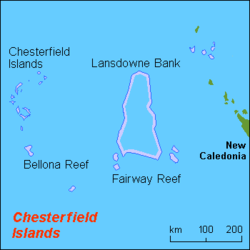
Lansdowne Bank
Encyclopedia
Bank (topography)
A bank, sometimes referred to as a fishing bank, is an area on the continental shelf which is shallow compared to its surrounding area, such as a shoal or the top of an underwater hill. Somewhat like continental slopes, ocean banks slopes can upwell as tidal and other flows intercept them,...
located between the main island of New Caledonia
New Caledonia
New Caledonia is a special collectivity of France located in the southwest Pacific Ocean, east of Australia and about from Metropolitan France. The archipelago, part of the Melanesia subregion, includes the main island of Grande Terre, the Loyalty Islands, the Belep archipelago, the Isle of...
and the Chesterfield Islands
Chesterfield Islands
Chesterfield Islands is a french archipelago of New Caledonia located in the Coral Sea, 550 km northwest of Grande Terre the main island of New Caledonia. Chesterfield Islands are a 120 km long and 70 km broad structure composed with 11 islets and many reefs...
, in the easternmost part of the Coral Sea
Coral Sea
The Coral Sea is a marginal sea off the northeast coast of Australia. It is bounded in the west by the east coast of Queensland, thereby including the Great Barrier Reef, in the east by Vanuatu and by New Caledonia, and in the north approximately by the southern extremity of the Solomon Islands...
. It covers an area of 21,000 km², making it one of the largest banks of the world (after Saya de Malha), has general depths of 60 to 80 metres, and a largely sandy bottom. Two reefs mark the shallowest spots of the bank, but they are still submerged at low tide.
Fairway Ridge, a submarine feature, is shown some maps in that area. Lansdowne Bank or Fairway Ridge, shown at the northeastern end of Lord Howe Rise
Lord Howe Rise
The Lord Howe Rise is an underwater plateau that extends from southwest of New Caledonia to the Challenger Plateau, west of New Zealand. To its west is the Tasman Basin and to the east is the New Caledonia Basin. Lord Howe Rise has a total area of about 1,500,000 square km, and generally lies about...
, are separated from New Caledonia by New Caledonia Basin and Fairway Basin.
Nereus Reef
At the northern end of Lansdowne Bank, Nereus Reef is located. Its given position of 20°07′S 160°28′E is doubtful http://permanent.access.gpo.gov/websites/pollux/pollux.nss.nima.mil/NAV_PUBS/SD/pub127/127sec06.pdf. Nereus Reef has the least depth of the bank, with 3.7 metres. A shoal with a depth of 16 metres is located 14 miles (23 km) km WNW of Nereus Reef.Fairway Reef
The southeastern end of Lansdowne Bank is marked by Fairway Reef, thus named from its lying in the fairwayChannel (geography)
In physical geography, a channel is the physical confine of a river, slough or ocean strait consisting of a bed and banks.A channel is also the natural or human-made deeper course through a reef, sand bar, bay, or any shallow body of water...
between Australia
Australia
Australia , officially the Commonwealth of Australia, is a country in the Southern Hemisphere comprising the mainland of the Australian continent, the island of Tasmania, and numerous smaller islands in the Indian and Pacific Oceans. It is the world's sixth-largest country by total area...
and New Caledonia
New Caledonia
New Caledonia is a special collectivity of France located in the southwest Pacific Ocean, east of Australia and about from Metropolitan France. The archipelago, part of the Melanesia subregion, includes the main island of Grande Terre, the Loyalty Islands, the Belep archipelago, the Isle of...
, midway between the Bellona Reefs (south of the Chesterfield Islands) and New Caledonia. Fairway Reef is 3.2 km long, about 4 to 5 fathom
Fathom
A fathom is a unit of length in the imperial and the U.S. customary systems, used especially for measuring the depth of water.There are 2 yards in an imperial or U.S. fathom...
s (7.3 to 9.1 metres) deep, of coral
Coral
Corals are marine animals in class Anthozoa of phylum Cnidaria typically living in compact colonies of many identical individual "polyps". The group includes the important reef builders that inhabit tropical oceans and secrete calcium carbonate to form a hard skeleton.A coral "head" is a colony of...
bottom, and located at 21°00′15"S 161°45′09"E. According to some sources, Fairway Reef dries at low tide http://www.reefbase.org/global_database/default.aspx?section=r1®ion=22&country=NCL.