
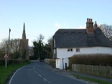
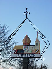
Landbeach
Encyclopedia
Fen
A fen is a type of wetland fed by mineral-rich surface water or groundwater. Fens are characterised by their water chemistry, which is neutral or alkaline, with relatively high dissolved mineral levels but few other plant nutrients...
-edge English
England
England is a country that is part of the United Kingdom. It shares land borders with Scotland to the north and Wales to the west; the Irish Sea is to the north west, the Celtic Sea to the south west, with the North Sea to the east and the English Channel to the south separating it from continental...
village
Village
A village is a clustered human settlement or community, larger than a hamlet with the population ranging from a few hundred to a few thousand , Though often located in rural areas, the term urban village is also applied to certain urban neighbourhoods, such as the West Village in Manhattan, New...
about five miles (8 km) north of Cambridge
Cambridge
The city of Cambridge is a university town and the administrative centre of the county of Cambridgeshire, England. It lies in East Anglia about north of London. Cambridge is at the heart of the high-technology centre known as Silicon Fen – a play on Silicon Valley and the fens surrounding the...
. The parish
Parish
A parish is a territorial unit historically under the pastoral care and clerical jurisdiction of one parish priest, who might be assisted in his pastoral duties by a curate or curates - also priests but not the parish priest - from a more or less central parish church with its associated organization...
covers an area of 9 km² (3 sq mi).
History
The fen edge north of Cambridge was well populated in Roman times, and the village's situation on a Roman road will have helped its growth. The road, the Mere Way (also called Akeman StreetAkeman Street
Akeman Street was a major Roman road in England that linked Watling Street with the Fosse Way. Its junction with Watling Steet was just north of Verulamium and that with the Fosse Way was at Corinium Dobunnorum...
), which once joined Ely
Ely, Cambridgeshire
Ely is a cathedral city in Cambridgeshire, England, 14 miles north-northeast of Cambridge and about by road from London. It is built on a Lower Greensand island, which at a maximum elevation of is the highest land in the Fens...
to London, passes through the village from north to south. Car Dyke
Car Dyke
The Car Dyke was, and to large extent still is, an eighty-five mile long ditch which runs along the western edge of the Fens in eastern England. It is generally accepted as being of Roman age and, for many centuries, to have been taken as marking the western edge of the Fens...
, the Roman drainage canal known locally as the Tilling, also runs through the village and in medieval times marked the boundary between the marshes of Landbeach and neighbouring Waterbeach
Waterbeach
Waterbeach is a large fen-edge village located 6 miles north of Cambridge in Cambridgeshire in England, and belongs to the administrative district of South Cambridgeshire. The parish covers an area of 23.26 km².- Village :...
. Drainage of the parish wasn't completed until the 18th century, and for much of the year large areas of the parish were inundated.
The village was listed as Utbech ("out bec") in the Domesday Book
Domesday Book
Domesday Book , now held at The National Archives, Kew, Richmond upon Thames in South West London, is the record of the great survey of much of England and parts of Wales completed in 1086...
and in the 13th and 14th century was occasionally referred to as Inbech ("in bec"). The original meaning of the "beach" part of the names is not universally agreed. One theory invokes the Anglo Saxon word bec meaning "stream", but a more plausible gives the meaning as "shore", much like the modern "beach", as both Waterbeach and Landbeach were at the edge of The Wash
The Wash
The Wash is the square-mouthed bay and estuary on the northwest margin of East Anglia on the east coast of England, where Norfolk meets Lincolnshire. It is among the largest estuaries in the United Kingdom...
.
Population reached a peak of 526 in 1851 falling to 389 in 1911. It passed 600 for the first time in the 1950s and 800 in the 1990s.
The village has three archaeological sites with remains of mediaeval manor houses, which together form a Scheduled Ancient Monument
Scheduled Ancient Monument
In the United Kingdom, a scheduled monument is a 'nationally important' archaeological site or historic building, given protection against unauthorized change. The various pieces of legislation used for legally protecting heritage assets from damage and destruction are grouped under the term...
.
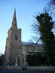
Church
Village life
Landbeach has two churches (Anglican and Baptist), a village hall and an Indian restaurant (formerly The Slap Up public housePublic house
A public house, informally known as a pub, is a drinking establishment fundamental to the culture of Britain, Ireland, Australia and New Zealand. There are approximately 53,500 public houses in the United Kingdom. This number has been declining every year, so that nearly half of the smaller...
). The nearest railway station is Waterbeach
Waterbeach
Waterbeach is a large fen-edge village located 6 miles north of Cambridge in Cambridgeshire in England, and belongs to the administrative district of South Cambridgeshire. The parish covers an area of 23.26 km².- Village :...
, on the Fen Line
Fen Line
The Fen Line is a railway in the United Kingdom that runs between the cities of Cambridge, Cambridgeshire and King's Lynn, Norfolk; the line is so called because it runs through The Fens. The line is part of the Network Rail Strategic Route 5 and comprises SRS 05.06 and part of 05.05...
. The village lies close to the A10 road that links Cambridge
Cambridge
The city of Cambridge is a university town and the administrative centre of the county of Cambridgeshire, England. It lies in East Anglia about north of London. Cambridge is at the heart of the high-technology centre known as Silicon Fen – a play on Silicon Valley and the fens surrounding the...
to King's Lynn
King's Lynn
King's Lynn is a sea port and market town in the ceremonial county of Norfolk in the East of England. It is situated north of London and west of Norwich. The population of the town is 42,800....
.
There were up to seven public houses in the village in the 19th century, of which none remain. These included The Black Bull which opened in the mid-18th century. The Black Bull, The Bower and The British Queen are now private houses and The Red Cow remains only in that a part of its tiled floor can be seen in the garden of one of the houses in the High Street. There is no remaining trace of The Windmill, The Coach and Horses, The Queen Adelaide or The Bricklayers Arms. By the 1960s only The Slap-Up, which opened in around 1860 on the Cambridge to Ely turnpike (now the A10) remained, but this is now a restaurant, renamed Bollywood Spice.
Within the parish boundary, but outside the residential area, is Cambridge Research Park, on the site of the former Landbeach Marina, itself a flooded former gravel pit
Gravel pit
Gravel pit is the term for an open cast working for extraction of gravel. Gravel pits often lie in river valleys where the water table is high, so they may fill naturally with water to form ponds or lakes. Old, abandoned gravel pits are normally used either as nature reserves, or as amenity areas...
.
Nearby villages
- ChitteringChittering, CambridgeshireChittering is a hamlet about 8 miles north of Cambridge in Cambridgeshire, England. For administrative purposes it is part of the parish of Waterbeach.The village lies on the Ely Road between Waterbeach and Stretham...
- WaterbeachWaterbeachWaterbeach is a large fen-edge village located 6 miles north of Cambridge in Cambridgeshire in England, and belongs to the administrative district of South Cambridgeshire. The parish covers an area of 23.26 km².- Village :...
- MiltonMilton, CambridgeshireMilton is a village just north of Cambridge, England. It has a population of approximately 4,300 with 3,200 being on the electoral register. It expanded considerably in the late 1980s when two large housing estates were built between the bypass and the village resulting in a doubling of the...
- CottenhamCottenhamCottenham is a village in Cambridgeshire, England. It is close to The Fens. Before the fens were drained in the 19th century Cottenham was on the last contour before the waterlogged marshes, with Ely being the nearest dry land around to the north-east....