
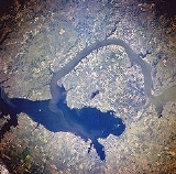
Lake Sakakawea
Encyclopedia
Lake Sakakawea is a reservoir
in the Missouri River
basin in central North Dakota
. Named for the Shoshone
-Hidatsa
woman Sakakawea, it is the third largest man-made lake
in the United States
, after Lake Mead
and Lake Powell
. The lake lies in parts of six counties in western North Dakota
: Dunn
, McKenzie
, McLean
, Mercer
, Mountrail
, and Williams
. A map centered around the Van Hook Arm 47°53′00"N 102°21′14"W of the lake perhaps better shows its westward extent from its origin at the Garrison Dam
.
It is located about 80 km (49.7 mi) from Bismarck, North Dakota
; the distance by the river is about 120 km (74.6 mi). The lake averages between 2 and 3 mi (3.2 and 4.8 km) in width and is 14 miles (22.5 km) wide at its widest point (Van Hook arm). Lake Sakakawea marks the maximum southwest extent of glaciation during the ice age
.
The reservoir was created with the completion of Garrison Dam
in 1956, the second (and largest) of six main-stem dams on the Missouri River built and managed by the U.S. Army Corps of Engineers for flood
control, hydroelectric power, navigation
and irrigation
.
The creation of the lake displaced members of the Fort Berthold Indian Reservation from the cities of Van Hook and (Old) Sanish, forcing the creation of New Town
. Incidentally, one name that had been proposed for New Town was 'Vanish' (a portmanteau of the two previous towns' names). A third reservation town, Elbowoods was also lost to the lake. These three towns are commemorated in the names of the 3 campground sections at Lake Sakakawea State Park.
Lake Sakakawea is also home to many summer camps, including Triangle Y Camp and Camp of the Cross.
that crosses the northern rim of the continental United States to Port Henry, New York
. The park was originally developed by the U.S. Army Corps of Engineers as Garrison Lake State Park. In 1965 the North Dakota Parks and Recreation Department assumed management of the park and renamed it Lake Sakakawea State Park in honor of the Shoshone
/Hidatsa
woman Sacagawea
who accompanied the Lewis and Clark Expedition
up the Missouri River from Fort Mandan in April 1805. The lake was not named Sacagawea State Park because the Native Americans in North Dakota prefer Sakakawea because that is believed to be her real name. Because of this in North Dakota anything related to Sacagawea is given the non-offensive term Sakakawea
Reservoir
A reservoir , artificial lake or dam is used to store water.Reservoirs may be created in river valleys by the construction of a dam or may be built by excavation in the ground or by conventional construction techniques such as brickwork or cast concrete.The term reservoir may also be used to...
in the Missouri River
Missouri River
The Missouri River flows through the central United States, and is a tributary of the Mississippi River. It is the longest river in North America and drains the third largest area, though only the thirteenth largest by discharge. The Missouri's watershed encompasses most of the American Great...
basin in central North Dakota
North Dakota
North Dakota is a state located in the Midwestern region of the United States of America, along the Canadian border. The state is bordered by Canada to the north, Minnesota to the east, South Dakota to the south and Montana to the west. North Dakota is the 19th-largest state by area in the U.S....
. Named for the Shoshone
Shoshone
The Shoshone or Shoshoni are a Native American tribe in the United States with three large divisions: the Northern, the Western and the Eastern....
-Hidatsa
Hidatsa
The Hidatsa are a Siouan people, a part of the Three Affiliated Tribes. The Hidatsa's autonym is Hiraacá. According to the tribal tradition, the word hiraacá derives from the word "willow"; however, the etymology is not transparent and the similarity to mirahací ‘willows’ inconclusive...
woman Sakakawea, it is the third largest man-made lake
Lake
A lake is a body of relatively still fresh or salt water of considerable size, localized in a basin, that is surrounded by land. Lakes are inland and not part of the ocean and therefore are distinct from lagoons, and are larger and deeper than ponds. Lakes can be contrasted with rivers or streams,...
in the United States
United States
The United States of America is a federal constitutional republic comprising fifty states and a federal district...
, after Lake Mead
Lake Mead
Lake Mead is the largest reservoir in the United States. It is located on the Colorado River about southeast of Las Vegas, Nevada, in the states of Nevada and Arizona. Formed by water impounded by the Hoover Dam, it extends behind the dam, holding approximately of water.-History:The lake was...
and Lake Powell
Lake Powell
Lake Powell is a huge reservoir on the Colorado River, straddling the border between Utah and Arizona . It is the second largest man-made reservoir in the United States behind Lake Mead, storing of water when full...
. The lake lies in parts of six counties in western North Dakota
North Dakota
North Dakota is a state located in the Midwestern region of the United States of America, along the Canadian border. The state is bordered by Canada to the north, Minnesota to the east, South Dakota to the south and Montana to the west. North Dakota is the 19th-largest state by area in the U.S....
: Dunn
Dunn County, North Dakota
-Major highways:*North Dakota Highway 8*North Dakota Highway 22*North Dakota Highway 200-Demographics:As of the census of 2000, there were 3,600 people, 1,378 households, and 986 families residing in the county. The population density was 2 people per square mile . There were 1,965 housing units...
, McKenzie
McKenzie County, North Dakota
-Major highways:* U.S. Highway 85* North Dakota Highway 22* North Dakota Highway 23* North Dakota Highway 58* North Dakota Highway 68* North Dakota Highway 73* North Dakota Highway 200* North Dakota Highway 1806-National protected areas:...
, McLean
McLean County, North Dakota
-Major highways:* U.S. Highway 83* North Dakota Highway 28* North Dakota Highway 37* North Dakota Highway 53* North Dakota Highway 41* North Dakota Highway 200* North Dakota Highway 1804-National protected areas:*Audubon National Wildlife Refuge...
, Mercer
Mercer County, North Dakota
-Major highways:* North Dakota Highway 31* North Dakota Highway 48* North Dakota Highway 49* North Dakota Highway 200* North Dakota Highway 1806-Demographics:...
, Mountrail
Mountrail County, North Dakota
-Major highways:* U.S. Highway 2* North Dakota Highway 8* North Dakota Highway 23* North Dakota Highway 31* North Dakota Highway 1804-National protected areas:*Lostwood National Wildlife Refuge *Shell Lake National Wildlife Refuge-Demographics:...
, and Williams
Williams County, North Dakota
-Major highways:* U.S. Highway 2* U.S. Highway 85* North Dakota Highway 40* North Dakota Highway 50* North Dakota Highway 1804-National protected areas:* Fort Union Trading Post National Historic Site * Lake Zahl National Wildlife Refuge...
. A map centered around the Van Hook Arm 47°53′00"N 102°21′14"W of the lake perhaps better shows its westward extent from its origin at the Garrison Dam
Garrison Dam
Garrison Dam is an earth-fill embankment dam on the Missouri River in central North Dakota. At over two miles in length, it is the fifth-largest earthen dam in the world, constructed by the U.S. Army Corps of Engineers from 1947-53...
.
It is located about 80 km (49.7 mi) from Bismarck, North Dakota
Bismarck, North Dakota
Bismarck is the capital of the U.S. state of North Dakota and the county seat of Burleigh County. It is the second most populous city in North Dakota after Fargo. The city's population was 61,272 at the 2010 census, while its metropolitan population was 108,779...
; the distance by the river is about 120 km (74.6 mi). The lake averages between 2 and 3 mi (3.2 and 4.8 km) in width and is 14 miles (22.5 km) wide at its widest point (Van Hook arm). Lake Sakakawea marks the maximum southwest extent of glaciation during the ice age
Ice age
An ice age or, more precisely, glacial age, is a generic geological period of long-term reduction in the temperature of the Earth's surface and atmosphere, resulting in the presence or expansion of continental ice sheets, polar ice sheets and alpine glaciers...
.
The reservoir was created with the completion of Garrison Dam
Garrison Dam
Garrison Dam is an earth-fill embankment dam on the Missouri River in central North Dakota. At over two miles in length, it is the fifth-largest earthen dam in the world, constructed by the U.S. Army Corps of Engineers from 1947-53...
in 1956, the second (and largest) of six main-stem dams on the Missouri River built and managed by the U.S. Army Corps of Engineers for flood
Flood
A flood is an overflow of an expanse of water that submerges land. The EU Floods directive defines a flood as a temporary covering by water of land not normally covered by water...
control, hydroelectric power, navigation
Navigation
Navigation is the process of monitoring and controlling the movement of a craft or vehicle from one place to another. It is also the term of art used for the specialized knowledge used by navigators to perform navigation tasks...
and irrigation
Irrigation
Irrigation may be defined as the science of artificial application of water to the land or soil. It is used to assist in the growing of agricultural crops, maintenance of landscapes, and revegetation of disturbed soils in dry areas and during periods of inadequate rainfall...
.
The creation of the lake displaced members of the Fort Berthold Indian Reservation from the cities of Van Hook and (Old) Sanish, forcing the creation of New Town
New Town, North Dakota
As of the census of 2000, there were 1,367 people, 488 households, and 318 families residing in the city. The population density was 2,031.6 people per square mile . There were 512 housing units at an average density of 760.9 per square mile...
. Incidentally, one name that had been proposed for New Town was 'Vanish' (a portmanteau of the two previous towns' names). A third reservation town, Elbowoods was also lost to the lake. These three towns are commemorated in the names of the 3 campground sections at Lake Sakakawea State Park.
Lake Sakakawea is also home to many summer camps, including Triangle Y Camp and Camp of the Cross.
Lake Sakakawea State Park
Lake Sakakawea State Park is the western terminus of the 7400 km (4,598.2 mi) North Country National Scenic Trail which is a National Millennium TrailNational Millennium Trail
National Millennium Trails are 16 long-distance trails selected from 58 nominees as visionary trails that reflect defining aspects America's history and culture...
that crosses the northern rim of the continental United States to Port Henry, New York
Port Henry, New York
Port Henry is a village in Essex County, New York, United States. The population was 1,152 at the 2000 census.The Village of Port Henry lies on the east side of the Town of Moriah and is approximately one hour's drive south of Plattsburgh...
. The park was originally developed by the U.S. Army Corps of Engineers as Garrison Lake State Park. In 1965 the North Dakota Parks and Recreation Department assumed management of the park and renamed it Lake Sakakawea State Park in honor of the Shoshone
Shoshone
The Shoshone or Shoshoni are a Native American tribe in the United States with three large divisions: the Northern, the Western and the Eastern....
/Hidatsa
Hidatsa
The Hidatsa are a Siouan people, a part of the Three Affiliated Tribes. The Hidatsa's autonym is Hiraacá. According to the tribal tradition, the word hiraacá derives from the word "willow"; however, the etymology is not transparent and the similarity to mirahací ‘willows’ inconclusive...
woman Sacagawea
Sacagawea
Sacagawea ; was a Lemhi Shoshone woman, who accompanied the Lewis and Clark Expedition, acting as an interpreter and guide, in their exploration of the Western United States...
who accompanied the Lewis and Clark Expedition
Lewis and Clark Expedition
The Lewis and Clark Expedition, or ″Corps of Discovery Expedition" was the first transcontinental expedition to the Pacific Coast by the United States. Commissioned by President Thomas Jefferson and led by two Virginia-born veterans of Indian wars in the Ohio Valley, Meriwether Lewis and William...
up the Missouri River from Fort Mandan in April 1805. The lake was not named Sacagawea State Park because the Native Americans in North Dakota prefer Sakakawea because that is believed to be her real name. Because of this in North Dakota anything related to Sacagawea is given the non-offensive term Sakakawea
Statistics
- Maximum water storage: 23800000 acre.ft
- Maximum water depth: 180 feet (54.9 m) at the face of the dam
- Normal surface area: 307000 acres (1,242.4 km²)
- Normal length: 178 miles (286.5 km)
- Normal shoreline: 1320 mi (2,124.3 km)
External links
- McLean County and Lake Sakakawea History
- History of Lake Sakakawea State Park