
Lake Enriquillo
Encyclopedia
Lake Enriquillo is a lake
in the Dominican Republic
and is the largest lake and lowest point in the Caribbean and the lowest point on any ocean island. It is one of only a few saltwater
lake
s in the world inhabited by crocodile
s. Lake Enriquillo
is located in a rift valley
formed by the Enriquillo-Plantain Garden fault
that extends 79 miles (127 km) from Port-au-Prince
Bay in Haiti
in the west, to near Neiba Bay in the Dominican Republic
in the east. This fault was responsible for the catastrophic 2010 Haiti earthquake
.
 The rift valley is a former marine strait, and was created around 1 million years ago when the water level fell and the strait was filled in by sediments of the Yaque del Sur River
. The lake is 9 to 12 miles (15 to 20 km) wide. Known as the Cul-de-Sac Depression
in Haiti and the Hoya de Enriquillo in the Dominican Republic, parts of the rift valley are below sea level and are covered by large salt lakes.
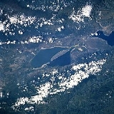
Lake Enriquillo covers an area of 102 square miles (265 km²) and is the lowest point in the Caribbean
falling 129 feet (39 m) below sea level. Its drainage basin
includes 10 minor river systems. The rivers that rise in the Neiba Mountains to the north (lower center and lower right of the image) are perennial. Those rivers that rise in the Baoruco Mountains to the south (upper center and upper left of the image) are intermittent.
Lake Enriquillo has no outlet. The lake's water level varies because of a combination of storm-driven precipitation events and the region's high evaporation
rate. Salinity in the lake can vary between 33 ppt to over 100 ppt. Tremors in the region are common. Just above the right center of the image, the other large salt lake in the rift valley, Etang Saumâtre
located in the country of Haiti, is visible.
The lake contains 3 islands: Isla Barbarita, Islita, and Isla Cabritos. The last one is the largest of all and contains a National Park famous for its crocodiles
and flamingo
s. When water levels drop as a result of dry spells, the islands are usually linked to each other by sandbars.
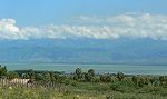
The region has a hot, semiarid climate with an average annual rainfall of about 24 inches. Plants that thrive in arid places, like the cactus, can be found here.
Lake
A lake is a body of relatively still fresh or salt water of considerable size, localized in a basin, that is surrounded by land. Lakes are inland and not part of the ocean and therefore are distinct from lagoons, and are larger and deeper than ponds. Lakes can be contrasted with rivers or streams,...
in the Dominican Republic
Dominican Republic
The Dominican Republic is a nation on the island of La Hispaniola, part of the Greater Antilles archipelago in the Caribbean region. The western third of the island is occupied by the nation of Haiti, making Hispaniola one of two Caribbean islands that are shared by two countries...
and is the largest lake and lowest point in the Caribbean and the lowest point on any ocean island. It is one of only a few saltwater
Seawater
Seawater is water from a sea or ocean. On average, seawater in the world's oceans has a salinity of about 3.5% . This means that every kilogram of seawater has approximately of dissolved salts . The average density of seawater at the ocean surface is 1.025 g/ml...
lake
Lake
A lake is a body of relatively still fresh or salt water of considerable size, localized in a basin, that is surrounded by land. Lakes are inland and not part of the ocean and therefore are distinct from lagoons, and are larger and deeper than ponds. Lakes can be contrasted with rivers or streams,...
s in the world inhabited by crocodile
American Crocodile
The American crocodile is a species of crocodilian found in the Neotropics. It is the most widespread of the four extant species of crocodiles from the Americas. Populations occur from the Atlantic and Pacific coasts of southern Mexico to South America as far as Peru and Venezuela. It also lives...
s. Lake Enriquillo
Enriquillo
Enriquillo was a Taíno Cacique who rebelled against the Spaniards from 1519 to 1533. His father was killed while attending peace talks with the Spanish, along with eighty other regional chieftains under the direction of his aunt Anacaona in Jaragua. During the talks, Spanish soldiers set the...
is located in a rift valley
Rift valley
A rift valley is a linear-shaped lowland between highlands or mountain ranges created by the action of a geologic rift or fault. This action is manifest as crustal extension, a spreading apart of the surface which is subsequently further deepened by the forces of erosion...
formed by the Enriquillo-Plantain Garden fault
Enriquillo-Plantain Garden fault zone
The Enriquillo–Plantain Garden fault zone is a system of coaxial left lateral-moving strike slip faults which runs along the southern side of the island of Hispaniola, where the Dominican Republic and Haiti are located...
that extends 79 miles (127 km) from Port-au-Prince
Port-au-Prince
Port-au-Prince is the capital and largest city of the Caribbean nation of Haiti. The city's population was 704,776 as of the 2003 census, and was officially estimated to have reached 897,859 in 2009....
Bay in Haiti
Haiti
Haiti , officially the Republic of Haiti , is a Caribbean country. It occupies the western, smaller portion of the island of Hispaniola, in the Greater Antillean archipelago, which it shares with the Dominican Republic. Ayiti was the indigenous Taíno or Amerindian name for the island...
in the west, to near Neiba Bay in the Dominican Republic
Dominican Republic
The Dominican Republic is a nation on the island of La Hispaniola, part of the Greater Antilles archipelago in the Caribbean region. The western third of the island is occupied by the nation of Haiti, making Hispaniola one of two Caribbean islands that are shared by two countries...
in the east. This fault was responsible for the catastrophic 2010 Haiti earthquake
2010 Haiti earthquake
The 2010 Haiti earthquake was a catastrophic magnitude 7.0 Mw earthquake, with an epicentre near the town of Léogâne, approximately west of Port-au-Prince, Haiti's capital. The earthquake occurred at 16:53 local time on Tuesday, 12 January 2010.By 24 January, at least 52 aftershocks...
.
Yaque del Sur River
The Yaque del Sur River is a river in the southwestern Dominican Republic. It is approximately 183 km in length....
. The lake is 9 to 12 miles (15 to 20 km) wide. Known as the Cul-de-Sac Depression
Cul-de-Sac Depression
The Plain of the Cul-de-Sac or Cul-de-Sac Depression is a lowland on the island of Hispaniola. It extends from southeastern Haiti into the southwestern Dominican Republic, where it is known as the Hoya de Enriquillo...
in Haiti and the Hoya de Enriquillo in the Dominican Republic, parts of the rift valley are below sea level and are covered by large salt lakes.
Lake Enriquillo covers an area of 102 square miles (265 km²) and is the lowest point in the Caribbean
Caribbean
The Caribbean is a crescent-shaped group of islands more than 2,000 miles long separating the Gulf of Mexico and the Caribbean Sea, to the west and south, from the Atlantic Ocean, to the east and north...
falling 129 feet (39 m) below sea level. Its drainage basin
Drainage basin
A drainage basin is an extent or an area of land where surface water from rain and melting snow or ice converges to a single point, usually the exit of the basin, where the waters join another waterbody, such as a river, lake, reservoir, estuary, wetland, sea, or ocean...
includes 10 minor river systems. The rivers that rise in the Neiba Mountains to the north (lower center and lower right of the image) are perennial. Those rivers that rise in the Baoruco Mountains to the south (upper center and upper left of the image) are intermittent.
Lake Enriquillo has no outlet. The lake's water level varies because of a combination of storm-driven precipitation events and the region's high evaporation
Evaporation
Evaporation is a type of vaporization of a liquid that occurs only on the surface of a liquid. The other type of vaporization is boiling, which, instead, occurs on the entire mass of the liquid....
rate. Salinity in the lake can vary between 33 ppt to over 100 ppt. Tremors in the region are common. Just above the right center of the image, the other large salt lake in the rift valley, Etang Saumâtre
Etang Saumâtre
Étang Saumâtre is the largest lake in Haiti and the second largest lake in Hispaniola, after Lake Enriquillo. It is also known as Lac Azuéi ; it is called Lago del Fondo in the Dominican Republic...
located in the country of Haiti, is visible.
The lake contains 3 islands: Isla Barbarita, Islita, and Isla Cabritos. The last one is the largest of all and contains a National Park famous for its crocodiles
American Crocodile
The American crocodile is a species of crocodilian found in the Neotropics. It is the most widespread of the four extant species of crocodiles from the Americas. Populations occur from the Atlantic and Pacific coasts of southern Mexico to South America as far as Peru and Venezuela. It also lives...
and flamingo
Caribbean Flamingo
The American Flamingo is a large species of flamingo closely related to the Greater Flamingo and Chilean Flamingo. It was formerly considered conspecific with the Greater Flamingo, but that treatment is now widely viewed as incorrect due to a lack of evidence...
s. When water levels drop as a result of dry spells, the islands are usually linked to each other by sandbars.
The region has a hot, semiarid climate with an average annual rainfall of about 24 inches. Plants that thrive in arid places, like the cactus, can be found here.