
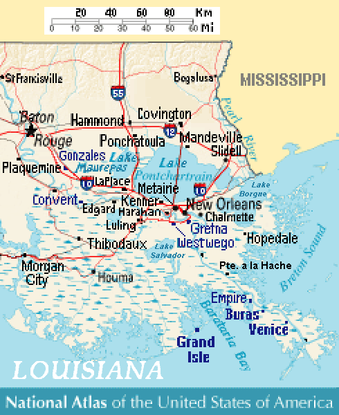
Lake Borgne
Encyclopedia
Lagoon
A lagoon is a body of shallow sea water or brackish water separated from the sea by some form of barrier. The EU's habitat directive defines lagoons as "expanses of shallow coastal salt water, of varying salinity or water volume, wholly or partially separated from the sea by sand banks or shingle,...
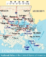
in eastern Louisiana
Louisiana
Louisiana is a state located in the southern region of the United States of America. Its capital is Baton Rouge and largest city is New Orleans. Louisiana is the only state in the U.S. with political subdivisions termed parishes, which are local governments equivalent to counties...
of the Gulf of Mexico
Gulf of Mexico
The Gulf of Mexico is a partially landlocked ocean basin largely surrounded by the North American continent and the island of Cuba. It is bounded on the northeast, north and northwest by the Gulf Coast of the United States, on the southwest and south by Mexico, and on the southeast by Cuba. In...
. Due to coastal erosion, it is no longer actually a lake but rather an arm of the Gulf of Mexico. Its name comes from the French
French language
French is a Romance language spoken as a first language in France, the Romandy region in Switzerland, Wallonia and Brussels in Belgium, Monaco, the regions of Quebec and Acadia in Canada, and by various communities elsewhere. Second-language speakers of French are distributed throughout many parts...
word borgne, which means "one-eyed".
Geography
The three large lakes, MaurepasLake Maurepas
Lake Maurepas is located in southeastern Louisiana approximately halfway between New Orleans and Baton Rouge directly west of Lake Pontchartrain.-Namesake:...
, Pontchartrain
Lake Pontchartrain
Lake Pontchartrain is a brackish estuary located in southeastern Louisiana. It is the second-largest inland saltwater body of water in the United States, after the Great Salt Lake in Utah, and the largest lake in Louisiana. As an estuary, Pontchartrain is not a true lake.It covers an area of with...
, and Borgne cover 55% of the Pontchartrain Basin. Lakes Maurepas and Pontchartrain are separated by land bridges of cypress swamp and fresh/intermediate marsh. A brackish marsh land bridge and Lake St. Catherine separate Lake Pontchartrain from Lake Borgne. The Rigolets and Chef Menteur Pass
Chef Menteur Pass
The Chef Menteur Pass is a narrow natural waterway which, along with the Rigolets, connects Lake Pontchartrain and Lake Borgne in New Orleans, Louisiana...
are the two open water connections between Pontchartrain and Borgne.
Due to coastal erosion
Coastal erosion
Coastal erosion is the wearing away of land and the removal of beach or dune sediments by wave action, tidal currents, wave currents, or drainage...
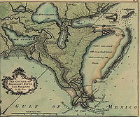
Borgne is now a lagoon connecting to the Gulf of Mexico, but early 18th century maps show it as a lake largely separated from the Gulf by a considerable extent of wetlands which have since disappeared.
The basin contains 483,390 acres (1956 km²) of wetlands, consisting of nearly 38,500 acres (156 km²) of fresh marsh, 28,600 acres (116 km²) of intermediate marsh, 116,800 acres (473 km²) of brackish marsh, 83,900 acres (340 km²) of saline marsh, and 215,600 acres (873 km²) of cypress swamp. Since 1932, more than 66,000 acres (267 km²) of marsh have converted to water in the Pontchartrain Basin — over 22% of the marsh that existed in 1932.
The primary causes of wetland loss in the basin are the interrelated effects of human activities and the estuarine processes that began to predominate many hundreds of years ago, as the delta was abandoned.
Ecology
The Mississippi RiverMississippi River
The Mississippi River is the largest river system in North America. Flowing entirely in the United States, this river rises in western Minnesota and meanders slowly southwards for to the Mississippi River Delta at the Gulf of Mexico. With its many tributaries, the Mississippi's watershed drains...
levees significantly limit the input of fresh water, sediment, and nutrients into the Pontchartrain basin. This reduction in input plays a part in the major critical problem in the Pontchartrain Basin — increased salinity
Salinity
Salinity is the saltiness or dissolved salt content of a body of water. It is a general term used to describe the levels of different salts such as sodium chloride, magnesium and calcium sulfates, and bicarbonates...
. Construction of the Mississippi River-Gulf Outlet Canal
Mississippi River-Gulf Outlet Canal
The Mississippi River – Gulf Outlet Canal is a channel constructed by the United States Army Corps of Engineers in the mid-20th century that provided a shorter route between the Gulf of Mexico and New Orleans' inner harbor Industrial Canal via the Intracoastal Waterway...
(MRGO), which breaches the natural barrier of the Bayou La Loutre ridge and the Borgne land bridge, allowed saline waters to push farther into the basin. Relative sea level rise of up to 0.96 feet per century (3 mm per year) gives saltier waters greater access to basin wetlands. Mean monthly salinities have increased since the construction of the MRGO and other canals. However, these mean increases are less than the overall variability in salinity. In recent years, salinities have stabilized. The heightened salinity, caused mainly by subsidence
Subsidence
Subsidence is the motion of a surface as it shifts downward relative to a datum such as sea-level. The opposite of subsidence is uplift, which results in an increase in elevation...
, stressed wetlands, especially freshwater marshes and swamps.
Taxodium distichum
Taxodium distichum is a species of conifer native to the southeastern United States.-Characteristics:...
on this land bridge either converted to marsh or became open water. These land bridges prevent estuarine processes, such as increased salinities and tidal scour
Tidal scour
Tidal scour is an erosion process which is carried out by the tidal movement of water.Examples of this hydrological process can be found in many areas of the world. Two locations in the United States where tidal scour is the predominant shaping force is the San Francisco Bay and the Elkhorn Slough....
, from pushing further into the middle and upper basins. If these buffers are not preserved, the land loss rates around Lakes Pontchartrain and Maurepas will increase dramatically.
The fourth critical problem is that several marshes in the basin are vulnerable to rapid loss if adequate protection is not provided soon. Examples of theses areas are: marshes adjacent to lakes and bays where if the narrow rim of shore is lost, interior erosion will increase dramatically; the perched fresh marsh on the MRGO disposal area which will drain and revegetate with shrub unless the back levee dikes are repaired; and near Bayou St. Malo
Saint Malo, Louisiana
Saint Malo was a small fishing village that existed in St. Bernard Parish, Louisiana on the shore of Lake Borgne from the mid 18th century into the early 20th century, when it was destroyed by the New Orleans Hurricane of 1915. It was the first settlement of Filipinos in the United...
, where unless canals are plugged, rapid water level fluctuations and salinity intrusion into adjacent marshes will continue.
Site specific problems of shoreline erosion, poor drainage, salinity stress, and herbivory are apparent throughout the basin. Solving these problems is important, but less urgent than solving the four critical problems described above.