
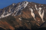
La Plata Peak
Encyclopedia
La Plata Peak is over fourteen thousand feet
in elevation and the fifth highest mountain in the U.S. state
of Colorado
. It is located in the Sawatch Range
in northwestern Chaffee County
, approximately 20 miles (32 km) southwest of Leadville, Colorado
, just south of Twin Lakes
and State Highway 82
on the east side of Independence Pass
. La Plata peak is located completely within the San Isabel National Forest
and is part of the Collegiate Peaks Wilderness
.
The peak's name means 'silver' in Spanish. This comes from the many silver deposits in the area. The nearby ghost towns of Winfield and Hamilton
were prominent silver mining towns in the early part of the 20th Century.
A Hayden Survey team first climbed the peak on July 26, 1873.
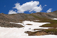 There are two commonly used routes to climb the mountain. One route begins near Winfield, to the south of the peak, and climbs north into a large marshy basin at 12000 foot. From here the trail becomes steeper as it scales a headwall to 13000 foot. From the top of the headwall it is a short rock scramble to the summit. The other route approaches the summit from the north. The trail starts from Highway 82 and follows the northern ridge that divides the La Plata basin from La Plata Gulch. Another more challenging and rarely used route is the northeast arm of the peak known as Ellingwood
Ridge.
Fourteener
In mountaineering terminology in the United States, a fourteener is a mountain that exceeds 14,000 feet above mean sea level. There are 547 fourteeners in the world. The importance of fourteeners is greatest in Colorado, which has the majority of such peaks in North America...
in elevation and the fifth highest mountain in the U.S. state
U.S. state
A U.S. state is any one of the 50 federated states of the United States of America that share sovereignty with the federal government. Because of this shared sovereignty, an American is a citizen both of the federal entity and of his or her state of domicile. Four states use the official title of...
of Colorado
Colorado
Colorado is a U.S. state that encompasses much of the Rocky Mountains as well as the northeastern portion of the Colorado Plateau and the western edge of the Great Plains...
. It is located in the Sawatch Range
Sawatch Range
The Sawatch Range is a mountain range in central Colorado which includes eight of the twenty highest peaks in the Rocky Mountains, including Mount Elbert, at elevation, the highest peak in the Rockies....
in northwestern Chaffee County
Chaffee County, Colorado
Chaffee County is one of the 64 counties of the state of Colorado of the United States. The county population was 16,242 at U.S. Census 2000. The county seat is Salida.-History:...
, approximately 20 miles (32 km) southwest of Leadville, Colorado
Leadville, Colorado
Leadville is a Statutory City that is the county seat of, and the only municipality in, Lake County, Colorado, United States. Situated at an elevation of , Leadville is the highest incorporated city and the second highest incorporated municipality in the United States...
, just south of Twin Lakes
Twin Lakes, Lake County, Colorado
Twin Lakes is a census-designated place and a U.S. Post Office located in Lake County, Colorado, United States. The population as of the 2010 Census was 171...
and State Highway 82
Colorado State Highway 82
State Highway 82 is an 85.29 mile long state highway in the U.S. state of Colorado.-Route description:SH 82 provides the principal transportation artery of the Roaring Fork Valley on the Colorado Western Slope, running from Interstate 70 at Glenwood Springs southeast past Carbondale, Basalt...
on the east side of Independence Pass
Independence Pass (Colorado)
Independence Pass, elevation , is a high mountain pass in the Rocky Mountains of central Colorado in the United States.The pass crosses the ridge of the Sawatch Range between Aspen and Leadville, on the border between Pitkin and Lake counties, and is within the White River National Forest...
. La Plata peak is located completely within the San Isabel National Forest
San Isabel National Forest
San Isabel National Forest is located in central Colorado. The forest contains 19 of the state's 54 fourteeners, peaks over high, including Mount Elbert, the highest point in Colorado....
and is part of the Collegiate Peaks Wilderness
Collegiate Peaks Wilderness
The Collegiate Peaks Wilderness is a area located in central Colorado between Leadville and Buena Vista to the east and Aspen to the west and Crested Butte to the southwest. Most of the area is in the San Isabel and Gunnison National Forests, with a smaller area in the White River National Forest...
.
The peak's name means 'silver' in Spanish. This comes from the many silver deposits in the area. The nearby ghost towns of Winfield and Hamilton
Hamilton, Colorado
Hamilton is an unincorporated town and a U.S. Post Office in Moffat County, Colorado, United States. The Hamilton Post Office has the ZIP Code 81638....
were prominent silver mining towns in the early part of the 20th Century.
A Hayden Survey team first climbed the peak on July 26, 1873.
Climbing Routes
Albert Russell Ellingwood
Albert Russell Ellingwood was a pioneering mountaineer and climber in the western United States during the first half of the twentieth century. He made first ascents of many peaks and routes in the Rocky Mountains, particularly in Colorado, including Lizard Head in the San Juan Mountains,...
Ridge.
See also
- List of Colorado fourteeners
- Mountain peaks of ColoradoMountain peaks of ColoradoThis article comprises three sortable tables of the major mountain peaks of the U.S. State of Colorado.Topographic elevation is the vertical distance above the reference geoid, a precise mathematical model of the Earth's sea level as an equipotential gravitational surface...
- Mountain ranges of ColoradoMountain ranges of ColoradoThe following table lists the major mountain ranges of the U.S. State of Colorado.-Mountain Ranges:-See also:*4000 meter peaks of Colorado*Colorado mountain passes*Geography of Colorado*Lists of mountains*Mountain peaks of Colorado...