
La Cienega, New Mexico
Encyclopedia
La Cienega is a census-designated place
(CDP) in Santa Fe County
, New Mexico
, United States
. It is part of the Santa Fe, New Mexico
Metropolitan Statistical Area. The population was 3,007 at the 2000 census.
According to the United States Census Bureau
, the CDP has a total area of 13.4 square miles (34.7 km²), all of it land.
of 2000, there were 3,007 people, 1,033 households, and 761 families residing in the CDP. The population density
was 225.3 people per square mile (87.0/km²). There were 1,079 housing units at an average density of 80.8 per square mile (31.2/km²). The racial makeup of the CDP was 60.86% White, 0.50% African American, 1.43% Native American, 0.30% Asian, 0.07% Pacific Islander, 31.19% from other races
, and 5.65% from two or more races. Hispanic or Latino of any race were 70.80% of the population.
There were 1,033 households out of which 44.9% had children under the age of 18 living with them, 56.1% were married couples
living together, 10.5% had a female householder with no husband present, and 26.3% were non-families. 19.2% of all households were made up of individuals and 2.2% had someone living alone who was 65 years of age or older. The average household size was 2.91 and the average family size was 3.35.
In the CDP the population was spread out with 31.1% under the age of 18, 8.8% from 18 to 24, 33.9% from 25 to 44, 22.0% from 45 to 64, and 4.3% who were 65 years of age or older. The median age was 32 years. For every 100 females there were 103.9 males. For every 100 females age 18 and over, there were 104.3 males.
The median income for a household in the CDP was $38,028, and the median income for a family was $46,578. Males had a median income of $31,178 versus $30,092 for females. The per capita income
for the CDP was $17,329. About 7.2% of families and 6.8% of the population were below the poverty line, including 3.3% of those under age 18 and 8.1% of those age 65 or over.
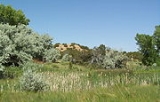
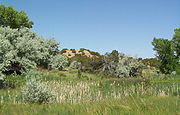 The name La Cienega refers to an important feature, a cienega
(spring and associated marsh) that supplies water to El Rancho de las Golondrinas
and the Santa Fe River
Canyon at the foot of the Caja del Rio. The cienega itself is managed by the Santa Fe Botanical Garden as the Leonora Curtin Wetland Preserve. La Cienega is an Area of Critical Environmental Concern
and has been a focus of recent efforts to create an open space corridor between Santa Fe and the Rio Grande
.
Census-designated place
A census-designated place is a concentration of population identified by the United States Census Bureau for statistical purposes. CDPs are delineated for each decennial census as the statistical counterparts of incorporated places such as cities, towns and villages...
(CDP) in Santa Fe County
Santa Fe County, New Mexico
-2010:Whereas according to the 2010 U.S. Census Bureau:*76.2% White*0.9% Black*3.1% Native American*1.2% Asian*0.1% Native Hawaiian or Pacific Islander*3.6% Two or more races*14.9% Other races*50.6% Hispanic or Latino -2000:...
, New Mexico
New Mexico
New Mexico is a state located in the southwest and western regions of the United States. New Mexico is also usually considered one of the Mountain States. With a population density of 16 per square mile, New Mexico is the sixth-most sparsely inhabited U.S...
, United States
United States
The United States of America is a federal constitutional republic comprising fifty states and a federal district...
. It is part of the Santa Fe, New Mexico
Santa Fe, New Mexico
Santa Fe is the capital of the U.S. state of New Mexico. It is the fourth-largest city in the state and is the seat of . Santa Fe had a population of 67,947 in the 2010 census...
Metropolitan Statistical Area. The population was 3,007 at the 2000 census.
Geography
La Cienega is located at 35°35′33"N 106°6′32"W (35.592537, -106.108947).According to the United States Census Bureau
United States Census Bureau
The United States Census Bureau is the government agency that is responsible for the United States Census. It also gathers other national demographic and economic data...
, the CDP has a total area of 13.4 square miles (34.7 km²), all of it land.
Demographics
As of the censusCensus
A census is the procedure of systematically acquiring and recording information about the members of a given population. It is a regularly occurring and official count of a particular population. The term is used mostly in connection with national population and housing censuses; other common...
of 2000, there were 3,007 people, 1,033 households, and 761 families residing in the CDP. The population density
Population density
Population density is a measurement of population per unit area or unit volume. It is frequently applied to living organisms, and particularly to humans...
was 225.3 people per square mile (87.0/km²). There were 1,079 housing units at an average density of 80.8 per square mile (31.2/km²). The racial makeup of the CDP was 60.86% White, 0.50% African American, 1.43% Native American, 0.30% Asian, 0.07% Pacific Islander, 31.19% from other races
Race (United States Census)
Race and ethnicity in the United States Census, as defined by the Federal Office of Management and Budget and the United States Census Bureau, are self-identification data items in which residents choose the race or races with which they most closely identify, and indicate whether or not they are...
, and 5.65% from two or more races. Hispanic or Latino of any race were 70.80% of the population.
There were 1,033 households out of which 44.9% had children under the age of 18 living with them, 56.1% were married couples
Marriage
Marriage is a social union or legal contract between people that creates kinship. It is an institution in which interpersonal relationships, usually intimate and sexual, are acknowledged in a variety of ways, depending on the culture or subculture in which it is found...
living together, 10.5% had a female householder with no husband present, and 26.3% were non-families. 19.2% of all households were made up of individuals and 2.2% had someone living alone who was 65 years of age or older. The average household size was 2.91 and the average family size was 3.35.
In the CDP the population was spread out with 31.1% under the age of 18, 8.8% from 18 to 24, 33.9% from 25 to 44, 22.0% from 45 to 64, and 4.3% who were 65 years of age or older. The median age was 32 years. For every 100 females there were 103.9 males. For every 100 females age 18 and over, there were 104.3 males.
The median income for a household in the CDP was $38,028, and the median income for a family was $46,578. Males had a median income of $31,178 versus $30,092 for females. The per capita income
Per capita income
Per capita income or income per person is a measure of mean income within an economic aggregate, such as a country or city. It is calculated by taking a measure of all sources of income in the aggregate and dividing it by the total population...
for the CDP was $17,329. About 7.2% of families and 6.8% of the population were below the poverty line, including 3.3% of those under age 18 and 8.1% of those age 65 or over.
Wetland
Cienega
A cienega or cienaga is a Spanish Colonial term for a spring, that is in use in English in the southwestern United States. A cienega usually is a wet, marshy area at the foot of a mountain, in a canyon, or on the edge of a grassland where groundwater bubbles to the surface...
(spring and associated marsh) that supplies water to El Rancho de las Golondrinas
El Rancho de las Golondrinas
El Rancho de las Golondrinas is a former ranch in the northern part of the U.S. state of New Mexico that has been recreated as a "living museum". Going north it was the last camping place on the Camino Real before reaching Santa Fe, New Mexico and a day's journey south of Santa Fe...
and the Santa Fe River
Santa Fe River (New Mexico)
The Santa Fe River is a tributary of the Rio Grande in northern New Mexico. It starts in the Sangre de Cristo mountain range and passes through the state capital, Santa Fe providing approximately 40% of the city's water supply. It is an...
Canyon at the foot of the Caja del Rio. The cienega itself is managed by the Santa Fe Botanical Garden as the Leonora Curtin Wetland Preserve. La Cienega is an Area of Critical Environmental Concern
Area of Critical Environmental Concern
Areas of Critical Environmental Concern is a conservation ecology program in the western United States, managed by the Bureau of Land Management. The ACEC program was conceived in the 1976 Federal Lands Policy and Management Act , which established the first conservation ecology mandate for the BLM...
and has been a focus of recent efforts to create an open space corridor between Santa Fe and the Rio Grande
Rio Grande
The Rio Grande is a river that flows from southwestern Colorado in the United States to the Gulf of Mexico. Along the way it forms part of the Mexico – United States border. Its length varies as its course changes...
.