
Kuroshio Current
Encyclopedia
The Kuroshio is a north-flowing ocean current
Ocean current
An ocean current is a continuous, directed movement of ocean water generated by the forces acting upon this mean flow, such as breaking waves, wind, Coriolis effect, cabbeling, temperature and salinity differences and tides caused by the gravitational pull of the Moon and the Sun...
on the west side of the North Pacific Ocean
Pacific Ocean
The Pacific Ocean is the largest of the Earth's oceanic divisions. It extends from the Arctic in the north to the Southern Ocean in the south, bounded by Asia and Australia in the west, and the Americas in the east.At 165.2 million square kilometres in area, this largest division of the World...
. It is similar to the Gulf Stream
Gulf Stream
The Gulf Stream, together with its northern extension towards Europe, the North Atlantic Drift, is a powerful, warm, and swift Atlantic ocean current that originates at the tip of Florida, and follows the eastern coastlines of the United States and Newfoundland before crossing the Atlantic Ocean...
in the North Atlantic and is part of the North Pacific ocean gyre. Like the Gulf stream, it is a strong western boundary current.
Physical properties
It begins off the east coast of TaiwanTaiwan
Taiwan , also known, especially in the past, as Formosa , is the largest island of the same-named island group of East Asia in the western Pacific Ocean and located off the southeastern coast of mainland China. The island forms over 99% of the current territory of the Republic of China following...
and flows northeastward past Japan
Japan
Japan is an island nation in East Asia. Located in the Pacific Ocean, it lies to the east of the Sea of Japan, China, North Korea, South Korea and Russia, stretching from the Sea of Okhotsk in the north to the East China Sea and Taiwan in the south...
, where it merges with the easterly drift of the North Pacific Current
North Pacific Current
The North Pacific Current is a slow warm water current that flows west-to-east between 40 and 50 degrees north in the Pacific Ocean. The current forms the southern part of the North Pacific Subpolar Gyre...
. It is analogous to the Gulf Stream
Gulf Stream
The Gulf Stream, together with its northern extension towards Europe, the North Atlantic Drift, is a powerful, warm, and swift Atlantic ocean current that originates at the tip of Florida, and follows the eastern coastlines of the United States and Newfoundland before crossing the Atlantic Ocean...
in the Atlantic Ocean
Atlantic Ocean
The Atlantic Ocean is the second-largest of the world's oceanic divisions. With a total area of about , it covers approximately 20% of the Earth's surface and about 26% of its water surface area...
, transporting warm, tropical water northward towards the polar region
Polar region
Earth's polar regions are the areas of the globe surrounding the poles also known as frigid zones. The North Pole and South Pole being the centers, these regions are dominated by the polar ice caps, resting respectively on the Arctic Ocean and the continent of Antarctica...
. It is also sometimes known as the Black Stream – the English translation of kuroshio, and an allusion to the deep blue of its water—and also as the .
The path of Kuroshio south of Japan is reported every day. Its counterparts are the North Pacific Current
North Pacific Current
The North Pacific Current is a slow warm water current that flows west-to-east between 40 and 50 degrees north in the Pacific Ocean. The current forms the southern part of the North Pacific Subpolar Gyre...
to the north, the California Current
California Current
The California Current is a Pacific Ocean current that moves south along the western coast of North America, beginning off southern British Columbia, and ending off southern Baja California. There are five major coastal currents affiliated with upwelling zones...
to the east, and the North Equatorial Current
North Equatorial Current
The North Equatorial Current is a significant Pacific and Atlantic Ocean current that flows east-to-west between about 10° north and 20° north. It is the southern side of a clockwise subtropical gyre. Despite its name, the North Equatorial Current is not connected to the equator...
to the south. The warm waters of the Kuroshio Current sustain the coral reef
Coral reef
Coral reefs are underwater structures made from calcium carbonate secreted by corals. Coral reefs are colonies of tiny living animals found in marine waters that contain few nutrients. Most coral reefs are built from stony corals, which in turn consist of polyps that cluster in groups. The polyps...
s of Japan, the northernmost coral reefs in the world. The branch into the Sea of Japan
Sea of Japan
The Sea of Japan is a marginal sea of the western Pacific Ocean, between the Asian mainland, the Japanese archipelago and Sakhalin. It is bordered by Japan, North Korea, Russia and South Korea. Like the Mediterranean Sea, it has almost no tides due to its nearly complete enclosure from the Pacific...
is called . The Japan Current is also responsible for the mild weather experienced around Alaska's southern coast and in British Columbia.
Distribution
Western boundary currents transport organisms long distances rapidly and a variety of commercially important marine organisms migrate in these currents in the course of completing their life histories. Subtropical gyres occupy a large fraction of the world's ocean and are more productive than originally thought. In addition, their fixation of carbon dioxideCarbon dioxide
Carbon dioxide is a naturally occurring chemical compound composed of two oxygen atoms covalently bonded to a single carbon atom...
is an important factor in the global budget for carbon dioxide in the atmosphere.
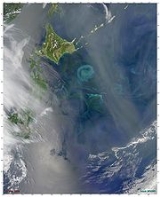
Satellite images of the Kuroshio Current illustrates how the current path meanders and forms isolated rings or eddies on the order of 100–300 km. Eddies retain their unique form for several months and have their own biological characteristics that depend on where they form. If the eddies are formed between the current and coastline of Japan, they may impinge on the continental shelf and their high kinetic energy
Kinetic energy
The kinetic energy of an object is the energy which it possesses due to its motion.It is defined as the work needed to accelerate a body of a given mass from rest to its stated velocity. Having gained this energy during its acceleration, the body maintains this kinetic energy unless its speed changes...
has the effect of drawing large volumes of water off the shelf on one side of the ring, while adding water to the other side. Eddies size and strength decline with distance from major ocean currents. The amount of energy decreases from the rings associated with the major currents and down to eddies remote from those currents. Cyclonic eddies have the potential to cause upwelling
Upwelling
Upwelling is an oceanographic phenomenon that involves wind-driven motion of dense, cooler, and usually nutrient-rich water towards the ocean surface, replacing the warmer, usually nutrient-depleted surface water. The increased availability in upwelling regions results in high levels of primary...
that would affect the global primary-production budget. Upwelling brings cold, nutrient rich water to the surface resulting in an increase in productivity
Productivity (ecology)
In ecology, productivity or production refers to the rate of generation of biomass in an ecosystem. It is usually expressed in units of mass per unit surface per unit time, for instance grams per square metre per day. The mass unit may relate to dry matter or to the mass of carbon generated...
. The biological consequences for young fish populations that inhabit the shelf are quite large.
Production

Impact of eddies
The Kuroshio is a warm current (24 °C annual average sea surface temperature), about 100 km wide and produces frequent small to meso-scale eddies. The Kuroshio Current is ranked as a moderately high productivity ecosystem (150-300 gCm−2y−1) based on SeaWiFsSeaWiFS
SeaWiFS stands for Sea-viewing Wide Field-of-view Sensor. It was the only scientific instrument on GeoEye's OrbView-2 satellite, and was a follow-on experiment to the Coastal Zone Color Scanner on Nimbus 7...
global primary productivity estimates. The coastal areas are highly productive and the maximum chlorophyll
Chlorophyll
Chlorophyll is a green pigment found in almost all plants, algae, and cyanobacteria. Its name is derived from the Greek words χλωρος, chloros and φύλλον, phyllon . Chlorophyll is an extremely important biomolecule, critical in photosynthesis, which allows plants to obtain energy from light...
value is found around 100 meters depth.
There are indications that eddies contribute to the preservation and survival of fish larvae transported by the Kuroshio. Plankton
Plankton
Plankton are any drifting organisms that inhabit the pelagic zone of oceans, seas, or bodies of fresh water. That is, plankton are defined by their ecological niche rather than phylogenetic or taxonomic classification...
biomass fluctuates yearly and is typically highest in the eddy area of the Kuroshio’s edge. Warm-core rings are not known for having high productivity. However, the biology of the warm-core rings from the Kuroshio Current show results of productivity equally distributed throughout for a couple of reasons. One is upwelling
Upwelling
Upwelling is an oceanographic phenomenon that involves wind-driven motion of dense, cooler, and usually nutrient-rich water towards the ocean surface, replacing the warmer, usually nutrient-depleted surface water. The increased availability in upwelling regions results in high levels of primary...
at the periphery and two, the convective mixing
Convection
Convection is the movement of molecules within fluids and rheids. It cannot take place in solids, since neither bulk current flows nor significant diffusion can take place in solids....
caused by the cooling of surface water as the ring moves north of the current. The thermostad is the deep mixed layer
Mixed layer
The oceanic or limnological mixed layer is a layer in which active turbulence has homogenized some range of depths. The surface mixed layer is a layer where this turbulence is generated by winds, cooling, or processes such as evaporation or sea ice formation which result in an increase in salinity...
that has discrete boundaries and uniform temperature. Within this layer, nutrient-rich water is brought to the surface, which generates a burst of primary production
Primary production
400px|thumb|Global oceanic and terrestrial photoautotroph abundance, from September [[1997]] to August 2000. As an estimate of autotroph biomass, it is only a rough indicator of primary production potential, and not an actual estimate of it...
. Given that the water in the core of a ring has a different temperature regime than the shelf waters, there are times when a warm-core ring is undergoing its spring bloom
Spring bloom
The spring bloom is a strong increase in phytoplankton abundance that typically occurs in the early spring and lasts until late spring or early summer. This seasonal event is characteristic of temperate North Atlantic, sub-polar, and coastal waters...
while the surrounding shelf waters are not.
There are many complex interactions with the warm-core ring and thus lifetime productivity is not very different from the surrounding shelf water. A study in 1998 found that the primary productivity within a warm-core ring was almost the same as in the cold jet outside it, with evidence of upwelling of nutrients within the ring. In addition, there was discovery of dense populations of phytoplankton
Phytoplankton
Phytoplankton are the autotrophic component of the plankton community. The name comes from the Greek words φυτόν , meaning "plant", and πλαγκτός , meaning "wanderer" or "drifter". Most phytoplankton are too small to be individually seen with the unaided eye...
at the nutricline within a ring, presumably supported by upward mixing of nutrients. Furthermore, there have been acoustic
Acoustics
Acoustics is the interdisciplinary science that deals with the study of all mechanical waves in gases, liquids, and solids including vibration, sound, ultrasound and infrasound. A scientist who works in the field of acoustics is an acoustician while someone working in the field of acoustics...
studies in the warm-core ring, which showed intense sound scattering from zooplankton
Zooplankton
Zooplankton are heterotrophic plankton. Plankton are organisms drifting in oceans, seas, and bodies of fresh water. The word "zooplankton" is derived from the Greek zoon , meaning "animal", and , meaning "wanderer" or "drifter"...
and fish populations within the ring and very sparse acoustic signals outside of it.
Copepods have been used as indicator-species of water masses. It has been suggested that copepods have been transported from the Kuroshio Current into southwest Taiwan
Taiwan
Taiwan , also known, especially in the past, as Formosa , is the largest island of the same-named island group of East Asia in the western Pacific Ocean and located off the southeastern coast of mainland China. The island forms over 99% of the current territory of the Republic of China following...
through the Luzon Strait
Luzon Strait
The Luzon Strait is the strait between the island country of Taiwan and Luzon island of the Philippines. The strait thereby connects the Philippine Sea to the South China Sea in the western Pacific Ocean....
. The Kuroshio intrusion through the Luzon Strait and further into the South China Sea
South China Sea
The South China Sea is a marginal sea that is part of the Pacific Ocean, encompassing an area from the Singapore and Malacca Straits to the Strait of Taiwan of around...
may also explain why copepods show a very high diversity in adjacent waters of the intrusion areas. The Kuroshio Current intrusion has a major influence on C. sinicus and E. concinna, which are two copepod
Copepod
Copepods are a group of small crustaceans found in the sea and nearly every freshwater habitat. Some species are planktonic , some are benthic , and some continental species may live in limno-terrestrial habitats and other wet terrestrial places, such as swamps, under leaf fall in wet forests,...
species with higher index values for winter and originate from the East China Sea. During the SW monsoon
Monsoon
Monsoon is traditionally defined as a seasonal reversing wind accompanied by corresponding changes in precipitation, but is now used to describe seasonal changes in atmospheric circulation and precipitation associated with the asymmetric heating of land and sea...
, the South China Sea Surface Current moves northwards during the summer towards the Kuroshio Current. As a result of this water circulation, the zooplankton communities in the boundary waters are unique and diverse.
Fish
The biomass of fish stocks depends on the biomass of lower trophic levelTrophic level
The trophic level of an organism is the position it occupies in a food chain. The word trophic derives from the Greek τροφή referring to food or feeding. A food chain represents a succession of organisms that eat another organism and are, in turn, eaten themselves. The number of steps an organism...
s, primary production and on oceanic and atmospheric conditions. In the Kuroshio-Oyashio region, the fish catches depend on oceanographic conditions, such as the Oyashio’s southward intrusion and the Kuroshio’s large meander
Meander
A meander in general is a bend in a sinuous watercourse. A meander is formed when the moving water in a stream erodes the outer banks and widens its valley. A stream of any volume may assume a meandering course, alternately eroding sediments from the outside of a bend and depositing them on the...
south of Honshu. The Oyashio Current
Oyashio Current
, also known as Oya Siwo, Okhotsk or the Kurile current, is a cold subarctic ocean current that flows south and circulates counterclockwise in the western North Pacific Ocean. It collides with the Kuroshio Current off the eastern shore of Japan to form the North Pacific Current...
contains subarctic
Subarctic
The Subarctic is a region in the Northern Hemisphere immediately south of the true Arctic and covering much of Alaska, Canada, the north of Scandinavia, Siberia, and northern Mongolia...
water that is much colder and fresher than the resident water east of Honshu
Honshu
is the largest island of Japan. The nation's main island, it is south of Hokkaido across the Tsugaru Strait, north of Shikoku across the Inland Sea, and northeast of Kyushu across the Kanmon Strait...
. Thus, the Oyashio intrusion affects recruitment, biomass, and catch of species such as Pollock
Pollock
Pollock is the common name used for either of the two species of marine fish in the Pollachius genus. Both P. pollachius and P. virens are commonly referred to as pollock. Other names for P...
, sardine
Sardine
Sardines, or pilchards, are several types of small, oily fish related to herrings, family Clupeidae. Sardines are named after the Mediterranean island of Sardinia, around which they were once abundant....
, and anchovy
Anchovy
Anchovies are a family of small, common salt-water forage fish. There are 144 species in 17 genera, found in the Atlantic, Indian, and Pacific Oceans. Anchovies are usually classified as an oily fish.-Description:...
. When the Oyashio is well developed and protrudes southward, the cold waters are favorable for sardine production. The Kuroshio large meander development correlates with sardine recruitment and catch due to the proximity of the Kuroshio meander to the southern spawning grounds of sardine.
Squid
The Japanese squidSquid
Squid are cephalopods of the order Teuthida, which comprises around 300 species. Like all other cephalopods, squid have a distinct head, bilateral symmetry, a mantle, and arms. Squid, like cuttlefish, have eight arms arranged in pairs and two, usually longer, tentacles...
Todarodes pacificus has three stocks that breed at different seasons: winter, summer, and autumn. The winter spawning group is associated with the Kuroshio Current. After spawning in the period of January to April in the East China Sea
East China Sea
The East China Sea is a marginal sea east of China. It is a part of the Pacific Ocean and covers an area of 1,249,000 km² or 750,000 square miles.-Geography:...
, the larvae and juveniles travel north with the Kuroshio Current. They are turned inshore and are caught between the islands of Honshu
Honshu
is the largest island of Japan. The nation's main island, it is south of Hokkaido across the Tsugaru Strait, north of Shikoku across the Inland Sea, and northeast of Kyushu across the Kanmon Strait...
and Hokkaido
Hokkaido
, formerly known as Ezo, Yezo, Yeso, or Yesso, is Japan's second largest island; it is also the largest and northernmost of Japan's 47 prefectural-level subdivisions. The Tsugaru Strait separates Hokkaido from Honshu, although the two islands are connected by the underwater railway Seikan Tunnel...
during the summer. The summer spawning is in another part of the East China Sea, from which the larvae are entrained into the Tsushima current
Tsushima Strait
is the eastern channel of the Korea Strait, which lies between Korea and Japan, connecting the Sea of Japan and the East China Sea.The Tsushima Strait is the broader eastern channel to the east and southeast of Tsushima Island, with the Japanese islands of Honshū to the east and northeast, and...
that flows north between the islands of Japan and the mainland. Afterward, the current meets a southward flowing cold coastal current, the Liman Current
Sea of Japan
The Sea of Japan is a marginal sea of the western Pacific Ocean, between the Asian mainland, the Japanese archipelago and Sakhalin. It is bordered by Japan, North Korea, Russia and South Korea. Like the Mediterranean Sea, it has almost no tides due to its nearly complete enclosure from the Pacific...
, and the summer-spawned squid are fished along the boundary between the two. This illustrates the use of these western boundary currents as a rapid transport that enable the eggs and larvae to develop during winter in warm water, while the adults travel north with minimum energy expenditure to exploit the rich feeding grounds further north. Studies have reported that annual catches in Japan have gradually increased since the late 1980s and it has been proposed that changing environmental conditions have caused the autumn and winter spawning areas in the Tsushima Strait and near the Goto Islands
Goto Islands
The are Japanese islands in the East China Sea, off the western coast of Kyūshū. The islands are a part of Nagasaki Prefecture.- Geography :There are 140 islands in total, including five main islands:,,,, and....
to overlap. In addition, winter spawning sites over the continental shelf
Continental shelf
The continental shelf is the extended perimeter of each continent and associated coastal plain. Much of the shelf was exposed during glacial periods, but is now submerged under relatively shallow seas and gulfs, and was similarly submerged during other interglacial periods. The continental margin,...
and slope in the East China Sea are expanding.