
Korean Demilitarized Zone
Encyclopedia
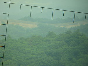
The Korean Demilitarized Zone is a strip of land running across the Korean Peninsula
that serves as a buffer zone
between North
and South Korea
. The DMZ
cuts the Korean Peninsula roughly in half, crossing the 38th parallel
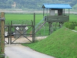
on an angle, with the west end of the DMZ lying south of the parallel and the east end lying north of it. It is 250 kilometres (155.3 mi) long, approximately 4 km (2.5 mi) wide and is the most heavily militarized border in the world. The Northern Limit Line
, or NLL, is the de facto maritime boundary
between North and South Korea in the Yellow Sea
and the coastline and islands on both sides of the NLL are also heavily militarized.
—which divides the Korean Peninsula roughly in half—was the original boundary between the United States and Soviet brief administration areas of Korea at the end of World War II
. Upon the creation of the Democratic People's Republic of Korea (DPRK, informally North Korea) and the Republic of Korea (ROK, informally South Korea) in 1948, it became a de facto
international border and one of the most tense fronts in the Cold War
.
Both the North and the South remained heavily dependent on their sponsor states from 1948 to the outbreak of the Korean War
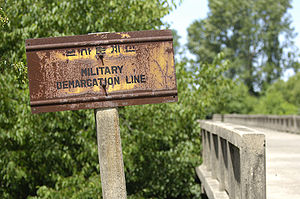
. The conflict, which claimed over three million lives and divided the Korean Peninsula along ideological lines, commenced on June 25, 1950, with a full-front DPRK invasion across the 38th parallel, and ended in 1953 after international intervention pushed the front of the war back to near the 38th parallel. In the Armistice Agreement of July 27, 1953, the DMZ was created as each side agreed to move their troops back 2000 metres (2,187.2 yd) from the front line, creating a buffer zone 4 km (2.5 mi) wide. The Military Demarcation Line (MDL) goes down the center of the DMZ and indicates exactly where the front was when the agreement was signed.
Since the Armistice was signed, it has been monitored by members of the Neutral Nations Supervisory Commission
(NNSC). Since 1953, members of the Swiss and Swedish Armed Forces have been members of the NNSC stationed near the DMZ.
Owing to this theoretical stalemate, and genuine hostility between the North and the South, large numbers of troops are still stationed along both sides of the line, each side guarding against potential aggression from the other side. The armistice agreement explains exactly how many military personnel and what kind of weapons are allowed in the DMZ. Soldiers from both sides may patrol inside the DMZ, but they may not cross the MDL. Sporadic outbreaks of violence due to North Korean hostilities killed over 500 South Korean soldiers and 50 U.S. soldiers along the DMZ between 1953 and 1999.
Tae Sung Dong and Kijong-dong were the only villages allowed by the armistice committee to remain within the boundaries of the DMZ. Residents of Tae Sung Dong are governed and protected by the United Nations Command and are generally required to spend at least 240 nights per year in the village to maintain their residency. In 2008, the village had a population of 218 people. The villagers of Tae Sung Dong are direct descendants of people who owned the land before the 1950–53 Korean War.
 Since demarcation, the DMZ has had numerous cases of incidents and incursions by the North Koreans, although the North Korean government never acknowledges direct responsibility for any of these incidents. These include:

 Inside the DMZ, near the western coast of the peninsula, Panmunjeom
is the home of the Joint Security Area (JSA). Originally, it was the only connection between North and South Korea but that changed in 2007 when a Korail
train crossed the DMZ to the North on the new Donghae Bukbu Line
built on the east coast of Korea.
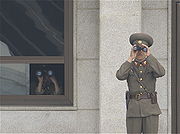
There are several buildings on both the north and the south side of the Military Demarcation Line, and a few are built right on top of the MDL. The Joint Security Area is the location where all negotiations since 1953 have been held, including statements of Korean solidarity, which have generally amounted to little except a slight decline of tensions. The MDL goes through the conference rooms and down the middle of the conference tables where the North Koreans and the United Nations Command (primarily South Koreans and Americans) meet face to face.
Though generally calm, the DMZ has been the scene of much saber-rattling
between the two Koreas over the years. Several small skirmishes have occurred within the Joint Security Area since 1953. The Axe Murder Incident
in August 1976 involved the attempted trimming of a poplar
tree which resulted in two deaths (CPT Arthur Bonifas and 1LT Mark Barrett) and Operation Paul Bunyan. Beforehand, the soldiers of both sides were permitted to go back and forth across the MDL inside of the JSA, a privilege since revoked as a result of this incident.
Another incident occurred on November 23, 1984, when a Soviet tourist, who was part of an official trip to the JSA (hosted by the North), ran across the Military Demarcation Line (MDL) shouting that he wanted to defect
. North Korean troops immediately chased after him opening fire. Border guards on the South Korean side returned fire eventually surrounding the North Koreans as they pursued the Russian national. One South Korean and three North Korean soldiers were killed in the action. The defector was not captured.
In late 2009, South Korean forces in conjunction with the United Nations Command
began renovation of its three guard posts and two checkpoint buildings within the JSA compound. Construction was designed to enlarge and modernise the structures. Work was undertaken a year after North Korea finished replacing four JSA guard posts on its side of the MDL.
; however, no coal has been found in the tunnels, which are dug through granite, but some of the tunnel walls have been painted black to give the appearance of anthracite.
The tunnels are believed to have been planned as a military invasion route by North Korea. Each shaft is large enough to permit the passage of an entire infantry division
in one hour, though the tunnels are not wide enough for tanks or vehicles. All the tunnels run in a north-south direction and do not have branches. Following each discovery, engineering within the tunnels has become progressively more advanced. For example, the third tunnel sloped slightly upwards as it progressed southward, to prevent water stagnation. Today, visitors may visit the second, third and fourth tunnels through guided tours.
The tunnel, which was about 1.2 m (4 ft) high by 0.9 m (3 ft) wide, extended more than 1000 m (1,093.6 yd) beyond the MDL into South Korea. The tunnel was reinforced with concrete slabs and had electric power and lighting. There were weapons storage and sleeping areas. A narrow gauge railway with carts had also been installed. Estimates based on the tunnel's size, suggest it would have allowed approximately 2,000 KPA
soldiers (one regiment) to pass through it per hour.
battlefield. The tunnel's dimensions are 2 m × 2 m and it is 145 m underground, the method of construction is almost identical in structure to the second and the third tunnels.

 Both North and South Korea maintain peace villages in sight of each other's side of the DMZ. In the South, Daeseong-dong
is administered under the terms of the DMZ. Villagers are classed as Republic of Korea citizens, however they are exempt from paying tax and other civic requirements such as military service.
In the North, Kijong-dong features a number of brightly painted, poured-concrete multi-story buildings and apartments with electric lighting. These features represented an unheard of level of luxury for rural Koreans, north or south, in the 1950s. The town was oriented so that the bright blue roofs and white sides of the buildings would be the most distinguishing features when viewed from the border. However scrutiny with modern telescopic lenses reveals that the buildings are mere concrete shells lacking window glass or even interior rooms, with the building lights turned on and off at set times and the empty sidewalks swept by a skeleton crew of caretakers in an effort to preserve the illusion of activity.
Until 2004, massive loudspeakers mounted on several of the buildings continuously delivered DPRK propaganda broadcasts directed towards the south as well as propaganda radio broadcasts across the border.
Within the JSA
are a number of U.N.
buildings called Conference Row. These are used for direct talks between the two Koreas. Facing the UN buildings is DPRK's Panmungak (Panmun Hall) and ROK's Freedom House. In 1994, North Korea enlarged Panmungak by adding a third floor. In 1998, South Korea built a new Freedom House for its Red Cross staff and to possibly host reunions of families separated by the Korean War
. The new building incorporated the old Freedom House Pagoda within its design.
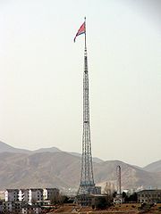
In 1980s, the South Korean government built a 98.4 m (323 ft) tall flagpole with a 130 kg (287 lb) South Korean flag
in Daeseong-dong
. The North Korean government responded by building what was then the tallest flagpole in the world at 160 m (525 ft) with a 270 kg (595 lb) North Korean flag
in Kijŏng-dong near Panmunjom, in what some have called the "flagpole war." The flagpole was superseded as the world's tallest, following the construction of the flagpole in Baku
's National Flag Square
at 162 m (531 ft). Both flagpoles have recently been topped by the Dushanbe Flagpole
in Tajikistan
, at 165 m (541 ft).
 The Korean wall is a concrete barrier that was allegedly built along the length of the DMZ in South Korea
between 1977 and 1979. Dutch journalist and filmmaker Peter Tetteroo
shows footage of what he believes (at the prompting of his North Korean guides) to be the Korean Wall. North Korea contends:
In December 1999, Chu Chang Jun, North Korea's longtime ambassador to China, repeated claims that a "wall" divided Korea. He said the south side of the wall is packed with soil, which permits access to the top of the wall and makes it effectively invisible from the south side. He also claimed that it served as a bridgehead for any northward invasion
.
According to the United States, the wall does not exist, although there are anti-tank barriers along some sections of the DMZ.
 Panmunjeom
is the site of the negotiations that ended the Korean War and is the main centre of human activity in the DMZ. The village is located on the main highway and near a railroad connecting the two Koreas.
The railway, which connects Seoul and Pyongyang, was called the Gyeongui Line
before division in the 1940s. Currently the South uses the original name, but the North refers to the route as the P'yŏngbu Line. The railway line has been mainly used to carry materials and South Korean workers to the Kaesong Industrial Region
. Its reconnection has been seen as part of the general thawing in the relations between North and South in the early part of this century. However in November 2008 North Korean authorities closed the railway amid growing tensions with the South. Following the death of former South Korean President Kim Dae-jung, conciliatory talks were held between South Korean officials and a North Korean delegation who attended Kim's funeral. In September 2009, the Kaesong rail and road crossing was reopened.
The road at Panmunjeom, which was known historically as Highway One in the South, was originally the only access point between the two countries on the Korean Peninsula. Passage is comparable to the strict movements that occurred at Checkpoint Charlie
in Berlin at the height of the Cold War
. Both North and South Korea's roads end in the Joint Security Area; neither highway meets because there is a 20 centimetres (8 in) concrete line that divides the entire site. People given the rare permission to cross this border must do so on foot before continuing their journey by road.
In 2007, on the east coast of Korea, the first train crossed the DMZ on the new Donghae Bukbu (Tonghae Pukpu) Line
. The new rail crossing was built adjacent to the road which took South Koreans to Kŭmgangsan
, a region that has significant cultural importance for all Koreans. More than one million civilian visitors crossed the DMZ until the route was closed following the shooting of a 53-year-old South Korean tourist in July 2008. After a joint investigation was rebuffed by the North, the Republic of Korean government suspended tours to the resort. Since then the resort and the Donghae Bukbu Line have effectively been closed by the North.
 In the past half century, the Korean DMZ has been a deadly place for humans, making habitation impossible. Only around the village of Panmunjeom
and more recently the Dong Bukbu Line on Korea's east coast have there been regular incursions by people.
This natural isolation along the 155 miles (249.4 km) length of the DMZ has created an involuntary park
which is now recognised as one of the most well-preserved areas of temperate habitat
in the world.
Several endangered animal and plant species now exist among the heavily fortified fences, landmines and listening posts. These include the extremely rare Red-crowned Crane
(a staple of Asian art), and the White-naped Crane
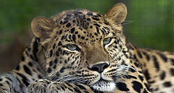
as well as, potentially, the extremely rare Korean Tiger, Amur leopard
and Asiatic black bear
. Ecologists have identified some 2,900 plant species, 70 types of mammals and 320 kinds of birds within the narrow buffer zone. Additional surveys are now being conducted throughout the region.
The DMZ owes its varied biodiversity
to its geography which crosses mountains, prairies, swamps, lakes and tidal marshes. Environmentalists hope that the DMZ will be conserved as a wildlife refuge
, with a well-developed set of objective and management plans vetted and in place. In 2005, CNN
founder and media mogul, Ted Turner
, on a visit to North Korea, said that he would financially support any plans to turn the DMZ into a peace park and a UN-protected World Heritage Site
.
|-
|
The Korean Demilitarized Zone is a strip of land running across the Korean Peninsula
that serves as a buffer zone
between North
and South Korea
. The DMZ
cuts the Korean Peninsula roughly in half, crossing the 38th parallel
on an angle, with the west end of the DMZ lying south of the parallel and the east end lying north of it. It is 250 kilometres (155.3 mi) long, approximately 4 km (2.5 mi) wide and is the most heavily militarized border in the world. The Northern Limit Line
, or NLL, is the de facto maritime boundary
between North and South Korea in the Yellow Sea
and the coastline and islands on both sides of the NLL are also heavily militarized.
—which divides the Korean Peninsula roughly in half—was the original boundary between the United States and Soviet brief administration areas of Korea at the end of World War II
. Upon the creation of the Democratic People's Republic of Korea (DPRK, informally North Korea) and the Republic of Korea (ROK, informally South Korea) in 1948, it became a de facto
international border and one of the most tense fronts in the Cold War
.
Both the North and the South remained heavily dependent on their sponsor states from 1948 to the outbreak of the Korean War
. The conflict, which claimed over three million lives and divided the Korean Peninsula along ideological lines, commenced on June 25, 1950, with a full-front DPRK invasion across the 38th parallel, and ended in 1953 after international intervention pushed the front of the war back to near the 38th parallel. In the Armistice Agreement of July 27, 1953, the DMZ was created as each side agreed to move their troops back 2000 metres (2,187.2 yd) from the front line, creating a buffer zone 4 km (2.5 mi) wide. The Military Demarcation Line (MDL) goes down the center of the DMZ and indicates exactly where the front was when the agreement was signed.
Since the Armistice was signed, it has been monitored by members of the Neutral Nations Supervisory Commission
(NNSC). Since 1953, members of the Swiss and Swedish Armed Forces have been members of the NNSC stationed near the DMZ.
Owing to this theoretical stalemate, and genuine hostility between the North and the South, large numbers of troops are still stationed along both sides of the line, each side guarding against potential aggression from the other side. The armistice agreement explains exactly how many military personnel and what kind of weapons are allowed in the DMZ. Soldiers from both sides may patrol inside the DMZ, but they may not cross the MDL. Sporadic outbreaks of violence due to North Korean hostilities killed over 500 South Korean soldiers and 50 U.S. soldiers along the DMZ between 1953 and 1999.
Tae Sung Dong and Kijong-dong were the only villages allowed by the armistice committee to remain within the boundaries of the DMZ. Residents of Tae Sung Dong are governed and protected by the United Nations Command and are generally required to spend at least 240 nights per year in the village to maintain their residency. In 2008, the village had a population of 218 people. The villagers of Tae Sung Dong are direct descendants of people who owned the land before the 1950–53 Korean War.
Since demarcation, the DMZ has had numerous cases of incidents and incursions by the North Koreans, although the North Korean government never acknowledges direct responsibility for any of these incidents. These include:
Inside the DMZ, near the western coast of the peninsula, Panmunjeom
is the home of the Joint Security Area (JSA). Originally, it was the only connection between North and South Korea but that changed in 2007 when a Korail
train crossed the DMZ to the North on the new Donghae Bukbu Line
built on the east coast of Korea.
There are several buildings on both the north and the south side of the Military Demarcation Line, and a few are built right on top of the MDL. The Joint Security Area is the location where all negotiations since 1953 have been held, including statements of Korean solidarity, which have generally amounted to little except a slight decline of tensions. The MDL goes through the conference rooms and down the middle of the conference tables where the North Koreans and the United Nations Command (primarily South Koreans and Americans) meet face to face.
Though generally calm, the DMZ has been the scene of much saber-rattling
between the two Koreas over the years. Several small skirmishes have occurred within the Joint Security Area since 1953. The Axe Murder Incident
in August 1976 involved the attempted trimming of a poplar
tree which resulted in two deaths (CPT Arthur Bonifas and 1LT Mark Barrett) and Operation Paul Bunyan. Beforehand, the soldiers of both sides were permitted to go back and forth across the MDL inside of the JSA, a privilege since revoked as a result of this incident.
Another incident occurred on November 23, 1984, when a Soviet tourist, who was part of an official trip to the JSA (hosted by the North), ran across the Military Demarcation Line (MDL) shouting that he wanted to defect
. North Korean troops immediately chased after him opening fire. Border guards on the South Korean side returned fire eventually surrounding the North Koreans as they pursued the Russian national. One South Korean and three North Korean soldiers were killed in the action. The defector was not captured.
In late 2009, South Korean forces in conjunction with the United Nations Command
began renovation of its three guard posts and two checkpoint buildings within the JSA compound. Construction was designed to enlarge and modernise the structures. Work was undertaken a year after North Korea finished replacing four JSA guard posts on its side of the MDL.
; however, no coal has been found in the tunnels, which are dug through granite, but some of the tunnel walls have been painted black to give the appearance of anthracite.
The tunnels are believed to have been planned as a military invasion route by North Korea. Each shaft is large enough to permit the passage of an entire infantry division
in one hour, though the tunnels are not wide enough for tanks or vehicles. All the tunnels run in a north-south direction and do not have branches. Following each discovery, engineering within the tunnels has become progressively more advanced. For example, the third tunnel sloped slightly upwards as it progressed southward, to prevent water stagnation. Today, visitors may visit the second, third and fourth tunnels through guided tours.
The tunnel, which was about 1.2 m (4 ft) high by 0.9 m (3 ft) wide, extended more than 1000 m (1,093.6 yd) beyond the MDL into South Korea. The tunnel was reinforced with concrete slabs and had electric power and lighting. There were weapons storage and sleeping areas. A narrow gauge railway with carts had also been installed. Estimates based on the tunnel's size, suggest it would have allowed approximately 2,000 KPA
soldiers (one regiment) to pass through it per hour.
battlefield. The tunnel's dimensions are 2 m × 2 m and it is 145 m underground, the method of construction is almost identical in structure to the second and the third tunnels.
Both North and South Korea maintain peace villages in sight of each other's side of the DMZ. In the South, Daeseong-dong
is administered under the terms of the DMZ. Villagers are classed as Republic of Korea citizens, however they are exempt from paying tax and other civic requirements such as military service.
In the North, Kijong-dong features a number of brightly painted, poured-concrete multi-story buildings and apartments with electric lighting. These features represented an unheard of level of luxury for rural Koreans, north or south, in the 1950s. The town was oriented so that the bright blue roofs and white sides of the buildings would be the most distinguishing features when viewed from the border. However scrutiny with modern telescopic lenses reveals that the buildings are mere concrete shells lacking window glass or even interior rooms, with the building lights turned on and off at set times and the empty sidewalks swept by a skeleton crew of caretakers in an effort to preserve the illusion of activity.
Until 2004, massive loudspeakers mounted on several of the buildings continuously delivered DPRK propaganda broadcasts directed towards the south as well as propaganda radio broadcasts across the border.
Within the JSA
are a number of U.N.
buildings called Conference Row. These are used for direct talks between the two Koreas. Facing the UN buildings is DPRK's Panmungak (Panmun Hall) and ROK's Freedom House. In 1994, North Korea enlarged Panmungak by adding a third floor. In 1998, South Korea built a new Freedom House for its Red Cross staff and to possibly host reunions of families separated by the Korean War
. The new building incorporated the old Freedom House Pagoda within its design.
In 1980s, the South Korean government built a 98.4 m (323 ft) tall flagpole with a 130 kg (287 lb) South Korean flag
in Daeseong-dong
. The North Korean government responded by building what was then the tallest flagpole in the world at 160 m (525 ft) with a 270 kg (595 lb) North Korean flag
in Kijŏng-dong near Panmunjom, in what some have called the "flagpole war." The flagpole was superseded as the world's tallest, following the construction of the flagpole in Baku
's National Flag Square
at 162 m (531 ft). Both flagpoles have recently been topped by the Dushanbe Flagpole
in Tajikistan
, at 165 m (541 ft).
The Korean wall is a concrete barrier that was allegedly built along the length of the DMZ in South Korea
between 1977 and 1979. Dutch journalist and filmmaker Peter Tetteroo
shows footage of what he believes (at the prompting of his North Korean guides) to be the Korean Wall. North Korea contends:
In December 1999, Chu Chang Jun, North Korea's longtime ambassador to China, repeated claims that a "wall" divided Korea. He said the south side of the wall is packed with soil, which permits access to the top of the wall and makes it effectively invisible from the south side. He also claimed that it served as a bridgehead for any northward invasion
.
According to the United States, the wall does not exist, although there are anti-tank barriers along some sections of the DMZ.
Panmunjeom
is the site of the negotiations that ended the Korean War and is the main centre of human activity in the DMZ. The village is located on the main highway and near a railroad connecting the two Koreas.
The railway, which connects Seoul and Pyongyang, was called the Gyeongui Line
before division in the 1940s. Currently the South uses the original name, but the North refers to the route as the P'yŏngbu Line. The railway line has been mainly used to carry materials and South Korean workers to the Kaesong Industrial Region
. Its reconnection has been seen as part of the general thawing in the relations between North and South in the early part of this century. However in November 2008 North Korean authorities closed the railway amid growing tensions with the South. Following the death of former South Korean President Kim Dae-jung, conciliatory talks were held between South Korean officials and a North Korean delegation who attended Kim's funeral. In September 2009, the Kaesong rail and road crossing was reopened.
The road at Panmunjeom, which was known historically as Highway One in the South, was originally the only access point between the two countries on the Korean Peninsula. Passage is comparable to the strict movements that occurred at Checkpoint Charlie
in Berlin at the height of the Cold War
. Both North and South Korea's roads end in the Joint Security Area; neither highway meets because there is a 20 centimetres (8 in) concrete line that divides the entire site. People given the rare permission to cross this border must do so on foot before continuing their journey by road.
In 2007, on the east coast of Korea, the first train crossed the DMZ on the new Donghae Bukbu (Tonghae Pukpu) Line
. The new rail crossing was built adjacent to the road which took South Koreans to Kŭmgangsan
, a region that has significant cultural importance for all Koreans. More than one million civilian visitors crossed the DMZ until the route was closed following the shooting of a 53-year-old South Korean tourist in July 2008. After a joint investigation was rebuffed by the North, the Republic of Korean government suspended tours to the resort. Since then the resort and the Donghae Bukbu Line have effectively been closed by the North.
In the past half century, the Korean DMZ has been a deadly place for humans, making habitation impossible. Only around the village of Panmunjeom
and more recently the Dong Bukbu Line on Korea's east coast have there been regular incursions by people.
This natural isolation along the 155 miles (249.4 km) length of the DMZ has created an involuntary park
which is now recognised as one of the most well-preserved areas of temperate habitat
in the world.
Several endangered animal and plant species now exist among the heavily fortified fences, landmines and listening posts. These include the extremely rare Red-crowned Crane
(a staple of Asian art), and the White-naped Crane
as well as, potentially, the extremely rare Korean Tiger, Amur leopard
and Asiatic black bear
. Ecologists have identified some 2,900 plant species, 70 types of mammals and 320 kinds of birds within the narrow buffer zone. Additional surveys are now being conducted throughout the region.
The DMZ owes its varied biodiversity
to its geography which crosses mountains, prairies, swamps, lakes and tidal marshes. Environmentalists hope that the DMZ will be conserved as a wildlife refuge
, with a well-developed set of objective and management plans vetted and in place. In 2005, CNN
founder and media mogul, Ted Turner
, on a visit to North Korea, said that he would financially support any plans to turn the DMZ into a peace park and a UN-protected World Heritage Site
.
|-
|
|}
Korean Peninsula
The Korean Peninsula is a peninsula in East Asia. It extends southwards for about 684 miles from continental Asia into the Pacific Ocean and is surrounded by the Sea of Japan to the south, and the Yellow Sea to the west, the Korea Strait connecting the first two bodies of water.Until the end of...
that serves as a buffer zone
Buffer zone
A buffer zone is generally a zonal area that lies between two or more other areas , but depending on the type of buffer zone, the reason for it may be to segregate regions or to conjoin them....
between North
North Korea
The Democratic People’s Republic of Korea , , is a country in East Asia, occupying the northern half of the Korean Peninsula. Its capital and largest city is Pyongyang. The Korean Demilitarized Zone serves as the buffer zone between North Korea and South Korea...
and South Korea
South Korea
The Republic of Korea , , is a sovereign state in East Asia, located on the southern portion of the Korean Peninsula. It is neighbored by the People's Republic of China to the west, Japan to the east, North Korea to the north, and the East China Sea and Republic of China to the south...
. The DMZ
Demilitarized zone
In military terms, a demilitarized zone is an area, usually the frontier or boundary between two or more military powers , where military activity is not permitted, usually by peace treaty, armistice, or other bilateral or multilateral agreement...
cuts the Korean Peninsula roughly in half, crossing the 38th parallel
38th parallel north
The 38th parallel north is a circle of latitude that is 38 degrees north of the Earth's equatorial plane. It crosses Europe, the Mediterranean Sea, Asia, the Pacific Ocean, North America, and the Atlantic Ocean...
on an angle, with the west end of the DMZ lying south of the parallel and the east end lying north of it. It is 250 kilometres (155.3 mi) long, approximately 4 km (2.5 mi) wide and is the most heavily militarized border in the world. The Northern Limit Line
Northern Limit Line
The Northern Limit Line or North Limit Line is a disputed inter-Korea maritime demarcation line in the Yellow Sea between the Democratic People's Republic of Korea on the north, and the Republic of Korea on the south...
, or NLL, is the de facto maritime boundary
Maritime boundary
Maritime boundary is a conceptual means of division of the water surface of the planet into maritime areas that are defined through surrounding physical geography or by human geography. As such it usually includes areas of exclusive national rights over the mineral and biological resources,...
between North and South Korea in the Yellow Sea
Yellow Sea
The Yellow Sea is the name given to the northern part of the East China Sea, which is a marginal sea of the Pacific Ocean. It is located between mainland China and the Korean Peninsula. Its name comes from the sand particles from Gobi Desert sand storms that turn the surface of the water golden...
and the coastline and islands on both sides of the NLL are also heavily militarized.
History
The 38th parallel north38th parallel north
The 38th parallel north is a circle of latitude that is 38 degrees north of the Earth's equatorial plane. It crosses Europe, the Mediterranean Sea, Asia, the Pacific Ocean, North America, and the Atlantic Ocean...
—which divides the Korean Peninsula roughly in half—was the original boundary between the United States and Soviet brief administration areas of Korea at the end of World War II
World War II
World War II, or the Second World War , was a global conflict lasting from 1939 to 1945, involving most of the world's nations—including all of the great powers—eventually forming two opposing military alliances: the Allies and the Axis...
. Upon the creation of the Democratic People's Republic of Korea (DPRK, informally North Korea) and the Republic of Korea (ROK, informally South Korea) in 1948, it became a de facto
De facto
De facto is a Latin expression that means "concerning fact." In law, it often means "in practice but not necessarily ordained by law" or "in practice or actuality, but not officially established." It is commonly used in contrast to de jure when referring to matters of law, governance, or...
international border and one of the most tense fronts in the Cold War
Cold War
The Cold War was the continuing state from roughly 1946 to 1991 of political conflict, military tension, proxy wars, and economic competition between the Communist World—primarily the Soviet Union and its satellite states and allies—and the powers of the Western world, primarily the United States...
.
Both the North and the South remained heavily dependent on their sponsor states from 1948 to the outbreak of the Korean War
Korean War
The Korean War was a conventional war between South Korea, supported by the United Nations, and North Korea, supported by the People's Republic of China , with military material aid from the Soviet Union...
. The conflict, which claimed over three million lives and divided the Korean Peninsula along ideological lines, commenced on June 25, 1950, with a full-front DPRK invasion across the 38th parallel, and ended in 1953 after international intervention pushed the front of the war back to near the 38th parallel. In the Armistice Agreement of July 27, 1953, the DMZ was created as each side agreed to move their troops back 2000 metres (2,187.2 yd) from the front line, creating a buffer zone 4 km (2.5 mi) wide. The Military Demarcation Line (MDL) goes down the center of the DMZ and indicates exactly where the front was when the agreement was signed.
Since the Armistice was signed, it has been monitored by members of the Neutral Nations Supervisory Commission
Neutral Nations Supervisory Commission
The Neutral Nations Supervisory Commission was established by the Korean Armistice Agreement signed July 27, 1953, ending the Korean War...
(NNSC). Since 1953, members of the Swiss and Swedish Armed Forces have been members of the NNSC stationed near the DMZ.
Owing to this theoretical stalemate, and genuine hostility between the North and the South, large numbers of troops are still stationed along both sides of the line, each side guarding against potential aggression from the other side. The armistice agreement explains exactly how many military personnel and what kind of weapons are allowed in the DMZ. Soldiers from both sides may patrol inside the DMZ, but they may not cross the MDL. Sporadic outbreaks of violence due to North Korean hostilities killed over 500 South Korean soldiers and 50 U.S. soldiers along the DMZ between 1953 and 1999.
Tae Sung Dong and Kijong-dong were the only villages allowed by the armistice committee to remain within the boundaries of the DMZ. Residents of Tae Sung Dong are governed and protected by the United Nations Command and are generally required to spend at least 240 nights per year in the village to maintain their residency. In 2008, the village had a population of 218 people. The villagers of Tae Sung Dong are direct descendants of people who owned the land before the 1950–53 Korean War.
Incidents and Incursions
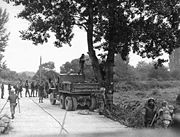
- October 1966–October 1969: Korean DMZ Conflict, a series of skirmishes along the DMZ results in 43 U.S., 299 South Korean and 397 North Korean soldiers killed
- January 17, 1968: 31 North Korean commandos crossed the border disguised as South Korean soldiers in the Blue House RaidBlue House RaidThe Blue House Raid was an unsuccessful attempt by North Korean commandos to assassinate the South Korean President Park Chung-hee at the Blue House on January 21, 1968.-Preparations:...
, an attempt to assassinate President Park Chung Hee at the Blue House. The failed mission resulted in 29 commandos killed (one committed suicide) and the other two captured. Two South Korean policemen and five civilians were killed by the commandos. Other reports indicated as many as 68 South Koreans killed and 66 wounded, including about 24 civilians. Three Americans were killed and another three wounded in an attempt to prevent the commandos from escaping back via the DMZ. - October 1968: 130 North Korean commandos entered the Ulchin and SamcheokSamcheokSamcheok is a city in Gangwon-do, South Korea.-Ancient age & Three Kingdom:* It was called "Siljikguk or Siljikgokguk"* 102 under the rule of Silla * 468 under the rule of Goguryeo...
areas in Gangwon-doGangwon-do (South Korea)Gangwon-do is a province of South Korea, with its capital at Chuncheon. Before the division of Korea in 1945, Gangwon and its North Korean neighbour Kangwŏn formed a single province.-History:...
. Eventually 110 of them were killed, 7 were captured and 13 escaped. - March 1969: Six North Korean infiltrators crossed the border near Chumunjin, Gangwon-do and killed a South Korean policeman on guard duty.
- April 1970: Three North Korean infiltrators were killed and five South Korean soldiers wounded at an encounter in KumchonKumchonKŭmch'ŏn is a county in North Hwanghae province, North Korea. It has a population of 68,216.-Geography:Kumchon is bordered to the west by Kaesong, to the south by Kaepung, to the northwest by Tosan, and to the north by Mt. Pakbong and Singye county. It is bordered to the east by the Ryesong River,...
, Gyeonggi-doGyeonggi-doGyeonggi-do is the most populous province in South Korea. The provincial capital is located at Suwon. Seoul—South Korea's largest city and national capital—is located in the heart of the province, but has been separately administered as a provincial-level special city since 1946...
. - November 20, 1974: The first of what would be a series of North Korean infiltration tunnels under the DMZ was discovered. The joint ROK-U.S. investigation team tripped a North Korean booby-trap killing one American and wounding 6 others.
- March 1975: The second North Korean infiltration tunnel was discovered.
- June 1976: Three North Korean infiltrators and six South Korean soldiers were killed in the eastern sector south of the DMZ. Another six South Korean soldiers were injured.
- August 18, 1976: The Axe Murder IncidentAxe Murder IncidentThe axe murder incident was the killing of two United States Army officers by North Korean soldiers on August 18, 1976, in the Joint Security Area located in the Korean Demilitarized Zone which forms the de facto border between North and South Korea...
resulted in the death of two U.S. soldiers and injuries to another four U.S. soldiers and five South Korean soldiers. The incident may not be technically considered an "infiltration" however, as it took place in a neutral zone of the Joint Security Area. - July 14, 1977: An American CH-47 ChinookCH-47 ChinookThe Boeing CH-47 Chinook is an American twin-engine, tandem rotor heavy-lift helicopter. Its top speed of 170 knots is faster than contemporary utility and attack helicopters of the 1960s...
helicopter was shot down after straying into the north over the DMZ. Three airmen were killed and one was briefly held prisoner (This was the sixth such incident since the Armistice was signed.) - October 1978: The third North Korean infiltration tunnelThird Tunnel of AggressionThe Third Tunnel of Aggression is a tunnel under the border between North Korea and South Korea, extending south of Panmunjom. It was the third tunnel to be discovered running under the border between the two Koreas.-Background:...
was discovered. - October 1979: Three North Korean agents attempting to infiltrate the eastern sector of the DMZ were intercepted, killing one of the agents.
- December 6, 1979: US patrol in the DMZ accidentally crosses the MDL into a North Korean minefield. One US soldier is killed and four are injured.
- March 1980: Three North Korean infiltrators were killed attempting to enter the south across the estuary of the Han RiverHan River (Korea)The Han River is a major river in South Korea and the fourth longest river on the Korean peninsula after the Amnok, Duman, and Nakdong rivers. It is formed by the confluence of the Namhan River , which originates in Mount Daedeok, and the Bukhan River , which originates on the slopes of Mount...
. - March 1981: Three North Korean infiltrators spotted at Kumhwa, Gangwon-do, one was killed.
- July 1981: Three North Korean infiltrators were killed in the upper stream of Imjin RiverImjin RiverThe Imjin River is a river of North and South Korea. It flows from North to South, crossing the Demilitarized Zone and joining the Han River downstream of Seoul, very near the Yellow Sea.- History :...
. - May 1982: Two North Korean infiltrators were spotted on the east coast, one was killed.
- March 1990: The fourth North Korean infiltration tunnel was discovered, in what may be a total of 17 tunnels in all.
- May 1992: Three North Korean infiltrators dressed in South Korean uniforms were killed at Cheorwon, Gangwon-do. Three South Koreans were also wounded.
- December 17, 1994: American OH-58A+ Kiowa helicopter crosses 10 km into North Korean territory and is shot down.
- October 1995: Two North Korean infiltrators were intercepted at Imjin River. One was killed, the other escaped.
- April 1996: Several hundred North Korean armed troops entered the Joint Security AreaJoint Security AreaThe Joint Security Area is the only portion of the Korean Demilitarized Zone where South and North Korean forces stand face-to-face. It is often called the "Truce Village" in both the media and various military accounts...
and elsewhere on three occasions in violation of the Korean armistice agreement. - May 1996: Seven North Korean soldiers crossed the DMZ but withdrew when fired upon by South Korean troops.
- April 1997: Five North Korean soldiers crossed the military demarcation line's Cheorwon sector and fired at South Korean positions.
- July 1997: Fourteen North Korean soldiers crossed the MDL, causing a 23-minute exchange of heavy gunfire.
- October 26, 2000: Two US aircraft observing a ROK army military exercise accidentally cross over the DMZ.
- May 26, 2006: Two North Korean soldiers entered the DMZ and crossed into South Korea. They returned after South Korean soldiers fired warning shots.
- October 7, 2006: South Korean soldiers fired warning shots after North Korean soldiers crossed briefly into their side of the border.
- October 27, 2009: A South Korean pig farmer, who was wanted for assault, cut a hole in the DMZ fence and defected to North Korea.
- October 29, 2010: Two shots were fired from North Korea towards a South Korean post near Hwacheon and South Korean troops fired three shots in return.
Joint Security Area
Panmunjeom
Panmunjom, located in Gyeonggi Province, is a village on the de facto border between North and South Korea, where the 1953 Korean Armistice Agreement that ended the Korean War was signed. The building where the armistice was signed still stands, though it is on the northern side of the Military...
is the home of the Joint Security Area (JSA). Originally, it was the only connection between North and South Korea but that changed in 2007 when a Korail
Korail
Korea Railroad Corporation , promoted as Korail , is the national railroad operator in South Korea.Korail operates passenger and freight trains throughout South Korea...
train crossed the DMZ to the North on the new Donghae Bukbu Line
Donghae Bukbu Line
The Donghae Bukbu Line is a former railway line that connected the present-day city of Anbyon in Kangwon Province, North Korea, with Yangyang, Gangwon Province, South Korea. It has not carried trains since the division of Korea. The line originally connected to the Gyeongwon Line running from...
built on the east coast of Korea.
There are several buildings on both the north and the south side of the Military Demarcation Line, and a few are built right on top of the MDL. The Joint Security Area is the location where all negotiations since 1953 have been held, including statements of Korean solidarity, which have generally amounted to little except a slight decline of tensions. The MDL goes through the conference rooms and down the middle of the conference tables where the North Koreans and the United Nations Command (primarily South Koreans and Americans) meet face to face.
Though generally calm, the DMZ has been the scene of much saber-rattling
Saber noise
Saber-noise or saber-rattling may be used to refer to a historical incident in Chilean history that took place on September 3, 1924, when a group of young military officers protested against the political class and the postponement of social measures by rattling their sabers within their scabbards...
between the two Koreas over the years. Several small skirmishes have occurred within the Joint Security Area since 1953. The Axe Murder Incident
Axe Murder Incident
The axe murder incident was the killing of two United States Army officers by North Korean soldiers on August 18, 1976, in the Joint Security Area located in the Korean Demilitarized Zone which forms the de facto border between North and South Korea...
in August 1976 involved the attempted trimming of a poplar
Poplar
Populus is a genus of 25–35 species of deciduous flowering plants in the family Salicaceae, native to most of the Northern Hemisphere. English names variously applied to different species include poplar , aspen, and cottonwood....
tree which resulted in two deaths (CPT Arthur Bonifas and 1LT Mark Barrett) and Operation Paul Bunyan. Beforehand, the soldiers of both sides were permitted to go back and forth across the MDL inside of the JSA, a privilege since revoked as a result of this incident.
Another incident occurred on November 23, 1984, when a Soviet tourist, who was part of an official trip to the JSA (hosted by the North), ran across the Military Demarcation Line (MDL) shouting that he wanted to defect
Defection
In politics, a defector is a person who gives up allegiance to one state or political entity in exchange for allegiance to another. More broadly, it involves abandoning a person, cause or doctrine to whom or to which one is bound by some tie, as of allegiance or duty.This term is also applied,...
. North Korean troops immediately chased after him opening fire. Border guards on the South Korean side returned fire eventually surrounding the North Koreans as they pursued the Russian national. One South Korean and three North Korean soldiers were killed in the action. The defector was not captured.
In late 2009, South Korean forces in conjunction with the United Nations Command
United Nations Command (Korea)
The United Nations Command is the unified command structure for the multinational military forces supporting the Republic of Korea during and after the Korean War...
began renovation of its three guard posts and two checkpoint buildings within the JSA compound. Construction was designed to enlarge and modernise the structures. Work was undertaken a year after North Korea finished replacing four JSA guard posts on its side of the MDL.
Incursion tunnels
Since November 15, 1974, the South has discovered that four tunnels crossing the DMZ have been dug by North Korea. This is indicated by the orientation of the blasting lines within each tunnel. Upon their discovery, North Korea claimed that the tunnels were for coal miningCoal mining
The goal of coal mining is to obtain coal from the ground. Coal is valued for its energy content, and since the 1880s has been widely used to generate electricity. Steel and cement industries use coal as a fuel for extraction of iron from iron ore and for cement production. In the United States,...
; however, no coal has been found in the tunnels, which are dug through granite, but some of the tunnel walls have been painted black to give the appearance of anthracite.
The tunnels are believed to have been planned as a military invasion route by North Korea. Each shaft is large enough to permit the passage of an entire infantry division
Division (military)
A division is a large military unit or formation usually consisting of between 10,000 and 20,000 soldiers. In most armies, a division is composed of several regiments or brigades, and in turn several divisions typically make up a corps...
in one hour, though the tunnels are not wide enough for tanks or vehicles. All the tunnels run in a north-south direction and do not have branches. Following each discovery, engineering within the tunnels has become progressively more advanced. For example, the third tunnel sloped slightly upwards as it progressed southward, to prevent water stagnation. Today, visitors may visit the second, third and fourth tunnels through guided tours.
First
The first of the tunnels was discovered by a South Korean Army patrol, noticing steam rising from the ground. The initial discovery was met with automatic fire from North Korean soldiers. Five days later, during a subsequent exploration of this tunnel, U.S. Navy Commander Robert M. Ballinger and ROK Marine Corps Major Kim Hah Chul were killed in the tunnel by a North Korean explosive device. The blast also wounded five Americans and one South Korean from the United Nations Command.The tunnel, which was about 1.2 m (4 ft) high by 0.9 m (3 ft) wide, extended more than 1000 m (1,093.6 yd) beyond the MDL into South Korea. The tunnel was reinforced with concrete slabs and had electric power and lighting. There were weapons storage and sleeping areas. A narrow gauge railway with carts had also been installed. Estimates based on the tunnel's size, suggest it would have allowed approximately 2,000 KPA
Korean People's Army
The Korean People's Army , also known as the Inmin Gun, are the military forces of the Democratic People's Republic of Korea. Kim Jong-il is the Supreme Commander of the Korean People's Army and Chairman of the National Defence Commission...
soldiers (one regiment) to pass through it per hour.
Second
The second tunnel was discovered on March 19, 1975. It is of similar length to the first tunnel. It is located between 50 and 160 m (164 and 524.9 ft) below ground, but is larger than the first, approximately 2 by.Third
The third tunnel was discovered on October 17, 1978. Unlike the previous two, the third tunnel was discovered following a tip from a North Korean defector. This tunnel is about 1600 m (1,749.8 yd) long and about 350 m (1,148.3 ft) below ground. Foreign visitors touring the South Korean DMZ may view inside this tunnel using a sloped access shaft.Fourth
A fourth tunnel was discovered on March 3, 1990, north of Haen town in the former PunchbowlBattle of Heartbreak Ridge
The Battle of Heartbreak Ridge , also known as the Battle of Wendengli , was a month-long battle in the Korean War fought between September 13 and October 15, 1951...
battlefield. The tunnel's dimensions are 2 m × 2 m and it is 145 m underground, the method of construction is almost identical in structure to the second and the third tunnels.
Buildings
Daeseong-dong
Daeseong-dong , South Korea, is a town in South Korea close to the North Korean border. It lies within the Korean Demilitarized Zone . The village is about one mile south of the Bridge of No Return towards the North and 7.5 miles from the city of Kaesong, North Korea.Daeseong-dong belongs...
is administered under the terms of the DMZ. Villagers are classed as Republic of Korea citizens, however they are exempt from paying tax and other civic requirements such as military service.
In the North, Kijong-dong features a number of brightly painted, poured-concrete multi-story buildings and apartments with electric lighting. These features represented an unheard of level of luxury for rural Koreans, north or south, in the 1950s. The town was oriented so that the bright blue roofs and white sides of the buildings would be the most distinguishing features when viewed from the border. However scrutiny with modern telescopic lenses reveals that the buildings are mere concrete shells lacking window glass or even interior rooms, with the building lights turned on and off at set times and the empty sidewalks swept by a skeleton crew of caretakers in an effort to preserve the illusion of activity.
Until 2004, massive loudspeakers mounted on several of the buildings continuously delivered DPRK propaganda broadcasts directed towards the south as well as propaganda radio broadcasts across the border.
Within the JSA
Joint Security Area
The Joint Security Area is the only portion of the Korean Demilitarized Zone where South and North Korean forces stand face-to-face. It is often called the "Truce Village" in both the media and various military accounts...
are a number of U.N.
United Nations
The United Nations is an international organization whose stated aims are facilitating cooperation in international law, international security, economic development, social progress, human rights, and achievement of world peace...
buildings called Conference Row. These are used for direct talks between the two Koreas. Facing the UN buildings is DPRK's Panmungak (Panmun Hall) and ROK's Freedom House. In 1994, North Korea enlarged Panmungak by adding a third floor. In 1998, South Korea built a new Freedom House for its Red Cross staff and to possibly host reunions of families separated by the Korean War
Korean War
The Korean War was a conventional war between South Korea, supported by the United Nations, and North Korea, supported by the People's Republic of China , with military material aid from the Soviet Union...
. The new building incorporated the old Freedom House Pagoda within its design.
In 1980s, the South Korean government built a 98.4 m (323 ft) tall flagpole with a 130 kg (287 lb) South Korean flag
Flag of South Korea
The flag of South Korea, or Taegeukgi has three parts: a white background; a red and blue taegeuk in the centre; and four black trigrams, one in each corner of the flag...
in Daeseong-dong
Daeseong-dong
Daeseong-dong , South Korea, is a town in South Korea close to the North Korean border. It lies within the Korean Demilitarized Zone . The village is about one mile south of the Bridge of No Return towards the North and 7.5 miles from the city of Kaesong, North Korea.Daeseong-dong belongs...
. The North Korean government responded by building what was then the tallest flagpole in the world at 160 m (525 ft) with a 270 kg (595 lb) North Korean flag
Flag of North Korea
The flag of North Korea was adopted on September 8, 1948, as the national flag and ensign. The red star of Communism can be seen on this flag on a white disc. The flag was adopted in 1948, when Northern portion of Korea became a Communist state. The traditional Korean flag was red, white, and blue...
in Kijŏng-dong near Panmunjom, in what some have called the "flagpole war." The flagpole was superseded as the world's tallest, following the construction of the flagpole in Baku
Baku
Baku , sometimes spelled as Baki or Bakou, is the capital and largest city of Azerbaijan, as well as the largest city on the Caspian Sea and of the Caucasus region. It is located on the southern shore of the Absheron Peninsula, which projects into the Caspian Sea. The city consists of two principal...
's National Flag Square
National Flag Square
National Flag Square is a large city square by Neftchiler Avenue in Bayil, Baku, Azerbaijan. Confirmed by the Guinness Book of Records, the flag flies on a pole 162 meters high and measures 70 by 35 meters which was the world's tallest flag, until it was overtaken by the 165 meter flagpole of...
at 162 m (531 ft). Both flagpoles have recently been topped by the Dushanbe Flagpole
Dushanbe Flagpole
Rising 165 metres in the air, the world’s tallest flagpole landed Tajikistan in the Guinness Book of World Records in August 2011. Built by American David Chambers, the tubular steel pole sections were built in Dubai, transported by sea to Iran, then shipped by truck - through Iran, Turkmenistan...
in Tajikistan
Tajikistan
Tajikistan , officially the Republic of Tajikistan , is a mountainous landlocked country in Central Asia. Afghanistan borders it to the south, Uzbekistan to the west, Kyrgyzstan to the north, and China to the east....
, at 165 m (541 ft).
Korean wall
South Korea
The Republic of Korea , , is a sovereign state in East Asia, located on the southern portion of the Korean Peninsula. It is neighbored by the People's Republic of China to the west, Japan to the east, North Korea to the north, and the East China Sea and Republic of China to the south...
between 1977 and 1979. Dutch journalist and filmmaker Peter Tetteroo
Peter Tetteroo
Peter Tetteroo is a Dutch journalist and filmmaker.Peter Tetteroo has worked as a senior director for world wide broadcasters since 1987.He has travelled to many countries in Europe, North and South America, Africa, Asia and Australia....
shows footage of what he believes (at the prompting of his North Korean guides) to be the Korean Wall. North Korea contends:
In December 1999, Chu Chang Jun, North Korea's longtime ambassador to China, repeated claims that a "wall" divided Korea. He said the south side of the wall is packed with soil, which permits access to the top of the wall and makes it effectively invisible from the south side. He also claimed that it served as a bridgehead for any northward invasion
Invasion
An invasion is a military offensive consisting of all, or large parts of the armed forces of one geopolitical entity aggressively entering territory controlled by another such entity, generally with the objective of either conquering, liberating or re-establishing control or authority over a...
.
According to the United States, the wall does not exist, although there are anti-tank barriers along some sections of the DMZ.
Transportation
Panmunjeom
Panmunjom, located in Gyeonggi Province, is a village on the de facto border between North and South Korea, where the 1953 Korean Armistice Agreement that ended the Korean War was signed. The building where the armistice was signed still stands, though it is on the northern side of the Military...
is the site of the negotiations that ended the Korean War and is the main centre of human activity in the DMZ. The village is located on the main highway and near a railroad connecting the two Koreas.
The railway, which connects Seoul and Pyongyang, was called the Gyeongui Line
Gyeongui Line
The Gyeongui Line is one of the oldest railway lines in Korea. When opened in 1906 it linked Seoul in what is now South Korea to P'yŏngyang and Sinŭiju in what is now North Korea...
before division in the 1940s. Currently the South uses the original name, but the North refers to the route as the P'yŏngbu Line. The railway line has been mainly used to carry materials and South Korean workers to the Kaesong Industrial Region
Kaesong Industrial Region
Kaesŏng Industrial Region is a special administrative industrial region of North Korea. It was formed in 2002 from part of Kaesŏng Directly Governed City.-Kaesŏng Industrial Park:...
. Its reconnection has been seen as part of the general thawing in the relations between North and South in the early part of this century. However in November 2008 North Korean authorities closed the railway amid growing tensions with the South. Following the death of former South Korean President Kim Dae-jung, conciliatory talks were held between South Korean officials and a North Korean delegation who attended Kim's funeral. In September 2009, the Kaesong rail and road crossing was reopened.
The road at Panmunjeom, which was known historically as Highway One in the South, was originally the only access point between the two countries on the Korean Peninsula. Passage is comparable to the strict movements that occurred at Checkpoint Charlie
Checkpoint Charlie
Checkpoint Charlie was the name given by the Western Allies to the best-known Berlin Wall crossing point between East Berlin and West Berlin during the Cold War....
in Berlin at the height of the Cold War
Cold War
The Cold War was the continuing state from roughly 1946 to 1991 of political conflict, military tension, proxy wars, and economic competition between the Communist World—primarily the Soviet Union and its satellite states and allies—and the powers of the Western world, primarily the United States...
. Both North and South Korea's roads end in the Joint Security Area; neither highway meets because there is a 20 centimetres (8 in) concrete line that divides the entire site. People given the rare permission to cross this border must do so on foot before continuing their journey by road.
In 2007, on the east coast of Korea, the first train crossed the DMZ on the new Donghae Bukbu (Tonghae Pukpu) Line
Donghae Bukbu Line
The Donghae Bukbu Line is a former railway line that connected the present-day city of Anbyon in Kangwon Province, North Korea, with Yangyang, Gangwon Province, South Korea. It has not carried trains since the division of Korea. The line originally connected to the Gyeongwon Line running from...
. The new rail crossing was built adjacent to the road which took South Koreans to Kŭmgangsan
Kumgangsan Tourist Region
The Kŭmgangsan Tourist Region is a special administrative region of North Korea. It was established in 2002 to handle South Korean tourist traffic to Kŭmgangsan ....
, a region that has significant cultural importance for all Koreans. More than one million civilian visitors crossed the DMZ until the route was closed following the shooting of a 53-year-old South Korean tourist in July 2008. After a joint investigation was rebuffed by the North, the Republic of Korean government suspended tours to the resort. Since then the resort and the Donghae Bukbu Line have effectively been closed by the North.
Nature reserve
Panmunjeom
Panmunjom, located in Gyeonggi Province, is a village on the de facto border between North and South Korea, where the 1953 Korean Armistice Agreement that ended the Korean War was signed. The building where the armistice was signed still stands, though it is on the northern side of the Military...
and more recently the Dong Bukbu Line on Korea's east coast have there been regular incursions by people.
This natural isolation along the 155 miles (249.4 km) length of the DMZ has created an involuntary park
Involuntary park
Involuntary park is a neologism coined by science fiction author and environmentalist Bruce Sterling to describe previously inhabited areas that for environmental, economic or political reasons have, in Sterling's words, "lost their value for technological instrumentalism" and been allowed to...
which is now recognised as one of the most well-preserved areas of temperate habitat
Habitat
* Habitat , a place where a species lives and grows*Human habitat, a place where humans live, work or play** Space habitat, a space station intended as a permanent settlement...
in the world.
Several endangered animal and plant species now exist among the heavily fortified fences, landmines and listening posts. These include the extremely rare Red-crowned Crane
Red-crowned Crane
The Red-crowned Crane , also called the Japanese Crane or Manchurian Crane , is a large east Asian crane and among the rarest cranes in the world...
(a staple of Asian art), and the White-naped Crane
White-naped Crane
The White-naped Crane is a bird of the crane family. It is a large bird, 112–125 cm long, approximately 130 cm tall and weighing about 5.6 kg with pinkish legs, grey and white striped neck, and a red face patch.The White-naped Crane breeds in northeastern Mongolia, northeastern...
as well as, potentially, the extremely rare Korean Tiger, Amur leopard
Amur Leopard
The Amur leopard , also known as the Far Eastern leopard, Korean leopard, and Manchurian leopard is one of nine recognised subspecies of leopard. It is a wild feline predator native to the mountainous areas of the Russian Far East. It used to inhabit the forests of Korea and China, but it has...
and Asiatic black bear
Asiatic Black Bear
The Asian black bear , also known as the moon bear or white-chested bear is a medium-sized species of bear, largely adapted for arboreal life, which occurs through much of southern Asia, Korea, northeastern China, the Russian far east and Honshū and Shikoku islands of Japan...
. Ecologists have identified some 2,900 plant species, 70 types of mammals and 320 kinds of birds within the narrow buffer zone. Additional surveys are now being conducted throughout the region.
The DMZ owes its varied biodiversity
Biodiversity
Biodiversity is the degree of variation of life forms within a given ecosystem, biome, or an entire planet. Biodiversity is a measure of the health of ecosystems. Biodiversity is in part a function of climate. In terrestrial habitats, tropical regions are typically rich whereas polar regions...
to its geography which crosses mountains, prairies, swamps, lakes and tidal marshes. Environmentalists hope that the DMZ will be conserved as a wildlife refuge
Nature reserve
A nature reserve is a protected area of importance for wildlife, flora, fauna or features of geological or other special interest, which is reserved and managed for conservation and to provide special opportunities for study or research...
, with a well-developed set of objective and management plans vetted and in place. In 2005, CNN
CNN
Cable News Network is a U.S. cable news channel founded in 1980 by Ted Turner. Upon its launch, CNN was the first channel to provide 24-hour television news coverage, and the first all-news television channel in the United States...
founder and media mogul, Ted Turner
Ted Turner
Robert Edward "Ted" Turner III is an American media mogul and philanthropist. As a businessman, he is known as founder of the cable news network CNN, the first dedicated 24-hour cable news channel. In addition, he founded WTBS, which pioneered the superstation concept in cable television...
, on a visit to North Korea, said that he would financially support any plans to turn the DMZ into a peace park and a UN-protected World Heritage Site
World Heritage Site
A UNESCO World Heritage Site is a place that is listed by the UNESCO as of special cultural or physical significance...
.
Gallery
{| align="center" border="0" cellpadding="4" cellspacing="4" style="border: 2px solid #9d9d9d;background-color:#eeeeee" valign="midlle"|-
|
The Korean Demilitarized Zone is a strip of land running across the Korean Peninsula
Korean Peninsula
The Korean Peninsula is a peninsula in East Asia. It extends southwards for about 684 miles from continental Asia into the Pacific Ocean and is surrounded by the Sea of Japan to the south, and the Yellow Sea to the west, the Korea Strait connecting the first two bodies of water.Until the end of...
that serves as a buffer zone
Buffer zone
A buffer zone is generally a zonal area that lies between two or more other areas , but depending on the type of buffer zone, the reason for it may be to segregate regions or to conjoin them....
between North
North Korea
The Democratic People’s Republic of Korea , , is a country in East Asia, occupying the northern half of the Korean Peninsula. Its capital and largest city is Pyongyang. The Korean Demilitarized Zone serves as the buffer zone between North Korea and South Korea...
and South Korea
South Korea
The Republic of Korea , , is a sovereign state in East Asia, located on the southern portion of the Korean Peninsula. It is neighbored by the People's Republic of China to the west, Japan to the east, North Korea to the north, and the East China Sea and Republic of China to the south...
. The DMZ
Demilitarized zone
In military terms, a demilitarized zone is an area, usually the frontier or boundary between two or more military powers , where military activity is not permitted, usually by peace treaty, armistice, or other bilateral or multilateral agreement...
cuts the Korean Peninsula roughly in half, crossing the 38th parallel
38th parallel north
The 38th parallel north is a circle of latitude that is 38 degrees north of the Earth's equatorial plane. It crosses Europe, the Mediterranean Sea, Asia, the Pacific Ocean, North America, and the Atlantic Ocean...
on an angle, with the west end of the DMZ lying south of the parallel and the east end lying north of it. It is 250 kilometres (155.3 mi) long, approximately 4 km (2.5 mi) wide and is the most heavily militarized border in the world. The Northern Limit Line
Northern Limit Line
The Northern Limit Line or North Limit Line is a disputed inter-Korea maritime demarcation line in the Yellow Sea between the Democratic People's Republic of Korea on the north, and the Republic of Korea on the south...
, or NLL, is the de facto maritime boundary
Maritime boundary
Maritime boundary is a conceptual means of division of the water surface of the planet into maritime areas that are defined through surrounding physical geography or by human geography. As such it usually includes areas of exclusive national rights over the mineral and biological resources,...
between North and South Korea in the Yellow Sea
Yellow Sea
The Yellow Sea is the name given to the northern part of the East China Sea, which is a marginal sea of the Pacific Ocean. It is located between mainland China and the Korean Peninsula. Its name comes from the sand particles from Gobi Desert sand storms that turn the surface of the water golden...
and the coastline and islands on both sides of the NLL are also heavily militarized.
History
The 38th parallel north38th parallel north
The 38th parallel north is a circle of latitude that is 38 degrees north of the Earth's equatorial plane. It crosses Europe, the Mediterranean Sea, Asia, the Pacific Ocean, North America, and the Atlantic Ocean...
—which divides the Korean Peninsula roughly in half—was the original boundary between the United States and Soviet brief administration areas of Korea at the end of World War II
World War II
World War II, or the Second World War , was a global conflict lasting from 1939 to 1945, involving most of the world's nations—including all of the great powers—eventually forming two opposing military alliances: the Allies and the Axis...
. Upon the creation of the Democratic People's Republic of Korea (DPRK, informally North Korea) and the Republic of Korea (ROK, informally South Korea) in 1948, it became a de facto
De facto
De facto is a Latin expression that means "concerning fact." In law, it often means "in practice but not necessarily ordained by law" or "in practice or actuality, but not officially established." It is commonly used in contrast to de jure when referring to matters of law, governance, or...
international border and one of the most tense fronts in the Cold War
Cold War
The Cold War was the continuing state from roughly 1946 to 1991 of political conflict, military tension, proxy wars, and economic competition between the Communist World—primarily the Soviet Union and its satellite states and allies—and the powers of the Western world, primarily the United States...
.
Both the North and the South remained heavily dependent on their sponsor states from 1948 to the outbreak of the Korean War
Korean War
The Korean War was a conventional war between South Korea, supported by the United Nations, and North Korea, supported by the People's Republic of China , with military material aid from the Soviet Union...
. The conflict, which claimed over three million lives and divided the Korean Peninsula along ideological lines, commenced on June 25, 1950, with a full-front DPRK invasion across the 38th parallel, and ended in 1953 after international intervention pushed the front of the war back to near the 38th parallel. In the Armistice Agreement of July 27, 1953, the DMZ was created as each side agreed to move their troops back 2000 metres (2,187.2 yd) from the front line, creating a buffer zone 4 km (2.5 mi) wide. The Military Demarcation Line (MDL) goes down the center of the DMZ and indicates exactly where the front was when the agreement was signed.
Since the Armistice was signed, it has been monitored by members of the Neutral Nations Supervisory Commission
Neutral Nations Supervisory Commission
The Neutral Nations Supervisory Commission was established by the Korean Armistice Agreement signed July 27, 1953, ending the Korean War...
(NNSC). Since 1953, members of the Swiss and Swedish Armed Forces have been members of the NNSC stationed near the DMZ.
Owing to this theoretical stalemate, and genuine hostility between the North and the South, large numbers of troops are still stationed along both sides of the line, each side guarding against potential aggression from the other side. The armistice agreement explains exactly how many military personnel and what kind of weapons are allowed in the DMZ. Soldiers from both sides may patrol inside the DMZ, but they may not cross the MDL. Sporadic outbreaks of violence due to North Korean hostilities killed over 500 South Korean soldiers and 50 U.S. soldiers along the DMZ between 1953 and 1999.
Tae Sung Dong and Kijong-dong were the only villages allowed by the armistice committee to remain within the boundaries of the DMZ. Residents of Tae Sung Dong are governed and protected by the United Nations Command and are generally required to spend at least 240 nights per year in the village to maintain their residency. In 2008, the village had a population of 218 people. The villagers of Tae Sung Dong are direct descendants of people who owned the land before the 1950–53 Korean War.
Incidents and Incursions
- October 1966–October 1969: Korean DMZ Conflict, a series of skirmishes along the DMZ results in 43 U.S., 299 South Korean and 397 North Korean soldiers killed
- January 17, 1968: 31 North Korean commandos crossed the border disguised as South Korean soldiers in the Blue House RaidBlue House RaidThe Blue House Raid was an unsuccessful attempt by North Korean commandos to assassinate the South Korean President Park Chung-hee at the Blue House on January 21, 1968.-Preparations:...
, an attempt to assassinate President Park Chung Hee at the Blue House. The failed mission resulted in 29 commandos killed (one committed suicide) and the other two captured. Two South Korean policemen and five civilians were killed by the commandos. Other reports indicated as many as 68 South Koreans killed and 66 wounded, including about 24 civilians. Three Americans were killed and another three wounded in an attempt to prevent the commandos from escaping back via the DMZ. - October 1968: 130 North Korean commandos entered the Ulchin and SamcheokSamcheokSamcheok is a city in Gangwon-do, South Korea.-Ancient age & Three Kingdom:* It was called "Siljikguk or Siljikgokguk"* 102 under the rule of Silla * 468 under the rule of Goguryeo...
areas in Gangwon-doGangwon-do (South Korea)Gangwon-do is a province of South Korea, with its capital at Chuncheon. Before the division of Korea in 1945, Gangwon and its North Korean neighbour Kangwŏn formed a single province.-History:...
. Eventually 110 of them were killed, 7 were captured and 13 escaped. - March 1969: Six North Korean infiltrators crossed the border near Chumunjin, Gangwon-do and killed a South Korean policeman on guard duty.
- April 1970: Three North Korean infiltrators were killed and five South Korean soldiers wounded at an encounter in KumchonKumchonKŭmch'ŏn is a county in North Hwanghae province, North Korea. It has a population of 68,216.-Geography:Kumchon is bordered to the west by Kaesong, to the south by Kaepung, to the northwest by Tosan, and to the north by Mt. Pakbong and Singye county. It is bordered to the east by the Ryesong River,...
, Gyeonggi-doGyeonggi-doGyeonggi-do is the most populous province in South Korea. The provincial capital is located at Suwon. Seoul—South Korea's largest city and national capital—is located in the heart of the province, but has been separately administered as a provincial-level special city since 1946...
. - November 20, 1974: The first of what would be a series of North Korean infiltration tunnels under the DMZ was discovered. The joint ROK-U.S. investigation team tripped a North Korean booby-trap killing one American and wounding 6 others.
- March 1975: The second North Korean infiltration tunnel was discovered.
- June 1976: Three North Korean infiltrators and six South Korean soldiers were killed in the eastern sector south of the DMZ. Another six South Korean soldiers were injured.
- August 18, 1976: The Axe Murder IncidentAxe Murder IncidentThe axe murder incident was the killing of two United States Army officers by North Korean soldiers on August 18, 1976, in the Joint Security Area located in the Korean Demilitarized Zone which forms the de facto border between North and South Korea...
resulted in the death of two U.S. soldiers and injuries to another four U.S. soldiers and five South Korean soldiers. The incident may not be technically considered an "infiltration" however, as it took place in a neutral zone of the Joint Security Area. - July 14, 1977: An American CH-47 ChinookCH-47 ChinookThe Boeing CH-47 Chinook is an American twin-engine, tandem rotor heavy-lift helicopter. Its top speed of 170 knots is faster than contemporary utility and attack helicopters of the 1960s...
helicopter was shot down after straying into the north over the DMZ. Three airmen were killed and one was briefly held prisoner (This was the sixth such incident since the Armistice was signed.) - October 1978: The third North Korean infiltration tunnelThird Tunnel of AggressionThe Third Tunnel of Aggression is a tunnel under the border between North Korea and South Korea, extending south of Panmunjom. It was the third tunnel to be discovered running under the border between the two Koreas.-Background:...
was discovered. - October 1979: Three North Korean agents attempting to infiltrate the eastern sector of the DMZ were intercepted, killing one of the agents.
- December 6, 1979: US patrol in the DMZ accidentally crosses the MDL into a North Korean minefield. One US soldier is killed and four are injured.
- March 1980: Three North Korean infiltrators were killed attempting to enter the south across the estuary of the Han RiverHan River (Korea)The Han River is a major river in South Korea and the fourth longest river on the Korean peninsula after the Amnok, Duman, and Nakdong rivers. It is formed by the confluence of the Namhan River , which originates in Mount Daedeok, and the Bukhan River , which originates on the slopes of Mount...
. - March 1981: Three North Korean infiltrators spotted at Kumhwa, Gangwon-do, one was killed.
- July 1981: Three North Korean infiltrators were killed in the upper stream of Imjin RiverImjin RiverThe Imjin River is a river of North and South Korea. It flows from North to South, crossing the Demilitarized Zone and joining the Han River downstream of Seoul, very near the Yellow Sea.- History :...
. - May 1982: Two North Korean infiltrators were spotted on the east coast, one was killed.
- March 1990: The fourth North Korean infiltration tunnel was discovered, in what may be a total of 17 tunnels in all.
- May 1992: Three North Korean infiltrators dressed in South Korean uniforms were killed at Cheorwon, Gangwon-do. Three South Koreans were also wounded.
- December 17, 1994: American OH-58A+ Kiowa helicopter crosses 10 km into North Korean territory and is shot down.
- October 1995: Two North Korean infiltrators were intercepted at Imjin River. One was killed, the other escaped.
- April 1996: Several hundred North Korean armed troops entered the Joint Security AreaJoint Security AreaThe Joint Security Area is the only portion of the Korean Demilitarized Zone where South and North Korean forces stand face-to-face. It is often called the "Truce Village" in both the media and various military accounts...
and elsewhere on three occasions in violation of the Korean armistice agreement. - May 1996: Seven North Korean soldiers crossed the DMZ but withdrew when fired upon by South Korean troops.
- April 1997: Five North Korean soldiers crossed the military demarcation line's Cheorwon sector and fired at South Korean positions.
- July 1997: Fourteen North Korean soldiers crossed the MDL, causing a 23-minute exchange of heavy gunfire.
- October 26, 2000: Two US aircraft observing a ROK army military exercise accidentally cross over the DMZ.
- May 26, 2006: Two North Korean soldiers entered the DMZ and crossed into South Korea. They returned after South Korean soldiers fired warning shots.
- October 7, 2006: South Korean soldiers fired warning shots after North Korean soldiers crossed briefly into their side of the border.
- October 27, 2009: A South Korean pig farmer, who was wanted for assault, cut a hole in the DMZ fence and defected to North Korea.
- October 29, 2010: Two shots were fired from North Korea towards a South Korean post near Hwacheon and South Korean troops fired three shots in return.
Joint Security Area
Panmunjeom
Panmunjom, located in Gyeonggi Province, is a village on the de facto border between North and South Korea, where the 1953 Korean Armistice Agreement that ended the Korean War was signed. The building where the armistice was signed still stands, though it is on the northern side of the Military...
is the home of the Joint Security Area (JSA). Originally, it was the only connection between North and South Korea but that changed in 2007 when a Korail
Korail
Korea Railroad Corporation , promoted as Korail , is the national railroad operator in South Korea.Korail operates passenger and freight trains throughout South Korea...
train crossed the DMZ to the North on the new Donghae Bukbu Line
Donghae Bukbu Line
The Donghae Bukbu Line is a former railway line that connected the present-day city of Anbyon in Kangwon Province, North Korea, with Yangyang, Gangwon Province, South Korea. It has not carried trains since the division of Korea. The line originally connected to the Gyeongwon Line running from...
built on the east coast of Korea.
There are several buildings on both the north and the south side of the Military Demarcation Line, and a few are built right on top of the MDL. The Joint Security Area is the location where all negotiations since 1953 have been held, including statements of Korean solidarity, which have generally amounted to little except a slight decline of tensions. The MDL goes through the conference rooms and down the middle of the conference tables where the North Koreans and the United Nations Command (primarily South Koreans and Americans) meet face to face.
Though generally calm, the DMZ has been the scene of much saber-rattling
Saber noise
Saber-noise or saber-rattling may be used to refer to a historical incident in Chilean history that took place on September 3, 1924, when a group of young military officers protested against the political class and the postponement of social measures by rattling their sabers within their scabbards...
between the two Koreas over the years. Several small skirmishes have occurred within the Joint Security Area since 1953. The Axe Murder Incident
Axe Murder Incident
The axe murder incident was the killing of two United States Army officers by North Korean soldiers on August 18, 1976, in the Joint Security Area located in the Korean Demilitarized Zone which forms the de facto border between North and South Korea...
in August 1976 involved the attempted trimming of a poplar
Poplar
Populus is a genus of 25–35 species of deciduous flowering plants in the family Salicaceae, native to most of the Northern Hemisphere. English names variously applied to different species include poplar , aspen, and cottonwood....
tree which resulted in two deaths (CPT Arthur Bonifas and 1LT Mark Barrett) and Operation Paul Bunyan. Beforehand, the soldiers of both sides were permitted to go back and forth across the MDL inside of the JSA, a privilege since revoked as a result of this incident.
Another incident occurred on November 23, 1984, when a Soviet tourist, who was part of an official trip to the JSA (hosted by the North), ran across the Military Demarcation Line (MDL) shouting that he wanted to defect
Defection
In politics, a defector is a person who gives up allegiance to one state or political entity in exchange for allegiance to another. More broadly, it involves abandoning a person, cause or doctrine to whom or to which one is bound by some tie, as of allegiance or duty.This term is also applied,...
. North Korean troops immediately chased after him opening fire. Border guards on the South Korean side returned fire eventually surrounding the North Koreans as they pursued the Russian national. One South Korean and three North Korean soldiers were killed in the action. The defector was not captured.
In late 2009, South Korean forces in conjunction with the United Nations Command
United Nations Command (Korea)
The United Nations Command is the unified command structure for the multinational military forces supporting the Republic of Korea during and after the Korean War...
began renovation of its three guard posts and two checkpoint buildings within the JSA compound. Construction was designed to enlarge and modernise the structures. Work was undertaken a year after North Korea finished replacing four JSA guard posts on its side of the MDL.
Incursion tunnels
Since November 15, 1974, the South has discovered that four tunnels crossing the DMZ have been dug by North Korea. This is indicated by the orientation of the blasting lines within each tunnel. Upon their discovery, North Korea claimed that the tunnels were for coal miningCoal mining
The goal of coal mining is to obtain coal from the ground. Coal is valued for its energy content, and since the 1880s has been widely used to generate electricity. Steel and cement industries use coal as a fuel for extraction of iron from iron ore and for cement production. In the United States,...
; however, no coal has been found in the tunnels, which are dug through granite, but some of the tunnel walls have been painted black to give the appearance of anthracite.
The tunnels are believed to have been planned as a military invasion route by North Korea. Each shaft is large enough to permit the passage of an entire infantry division
Division (military)
A division is a large military unit or formation usually consisting of between 10,000 and 20,000 soldiers. In most armies, a division is composed of several regiments or brigades, and in turn several divisions typically make up a corps...
in one hour, though the tunnels are not wide enough for tanks or vehicles. All the tunnels run in a north-south direction and do not have branches. Following each discovery, engineering within the tunnels has become progressively more advanced. For example, the third tunnel sloped slightly upwards as it progressed southward, to prevent water stagnation. Today, visitors may visit the second, third and fourth tunnels through guided tours.
First
The first of the tunnels was discovered by a South Korean Army patrol, noticing steam rising from the ground. The initial discovery was met with automatic fire from North Korean soldiers. Five days later, during a subsequent exploration of this tunnel, U.S. Navy Commander Robert M. Ballinger and ROK Marine Corps Major Kim Hah Chul were killed in the tunnel by a North Korean explosive device. The blast also wounded five Americans and one South Korean from the United Nations Command.The tunnel, which was about 1.2 m (4 ft) high by 0.9 m (3 ft) wide, extended more than 1000 m (1,093.6 yd) beyond the MDL into South Korea. The tunnel was reinforced with concrete slabs and had electric power and lighting. There were weapons storage and sleeping areas. A narrow gauge railway with carts had also been installed. Estimates based on the tunnel's size, suggest it would have allowed approximately 2,000 KPA
Korean People's Army
The Korean People's Army , also known as the Inmin Gun, are the military forces of the Democratic People's Republic of Korea. Kim Jong-il is the Supreme Commander of the Korean People's Army and Chairman of the National Defence Commission...
soldiers (one regiment) to pass through it per hour.
Second
The second tunnel was discovered on March 19, 1975. It is of similar length to the first tunnel. It is located between 50 and 160 m (164 and 524.9 ft) below ground, but is larger than the first, approximately 2 by.Third
The third tunnel was discovered on October 17, 1978. Unlike the previous two, the third tunnel was discovered following a tip from a North Korean defector. This tunnel is about 1600 m (1,749.8 yd) long and about 350 m (1,148.3 ft) below ground. Foreign visitors touring the South Korean DMZ may view inside this tunnel using a sloped access shaft.Fourth
A fourth tunnel was discovered on March 3, 1990, north of Haen town in the former PunchbowlBattle of Heartbreak Ridge
The Battle of Heartbreak Ridge , also known as the Battle of Wendengli , was a month-long battle in the Korean War fought between September 13 and October 15, 1951...
battlefield. The tunnel's dimensions are 2 m × 2 m and it is 145 m underground, the method of construction is almost identical in structure to the second and the third tunnels.
Buildings
Daeseong-dong
Daeseong-dong , South Korea, is a town in South Korea close to the North Korean border. It lies within the Korean Demilitarized Zone . The village is about one mile south of the Bridge of No Return towards the North and 7.5 miles from the city of Kaesong, North Korea.Daeseong-dong belongs...
is administered under the terms of the DMZ. Villagers are classed as Republic of Korea citizens, however they are exempt from paying tax and other civic requirements such as military service.
In the North, Kijong-dong features a number of brightly painted, poured-concrete multi-story buildings and apartments with electric lighting. These features represented an unheard of level of luxury for rural Koreans, north or south, in the 1950s. The town was oriented so that the bright blue roofs and white sides of the buildings would be the most distinguishing features when viewed from the border. However scrutiny with modern telescopic lenses reveals that the buildings are mere concrete shells lacking window glass or even interior rooms, with the building lights turned on and off at set times and the empty sidewalks swept by a skeleton crew of caretakers in an effort to preserve the illusion of activity.
Until 2004, massive loudspeakers mounted on several of the buildings continuously delivered DPRK propaganda broadcasts directed towards the south as well as propaganda radio broadcasts across the border.
Within the JSA
Joint Security Area
The Joint Security Area is the only portion of the Korean Demilitarized Zone where South and North Korean forces stand face-to-face. It is often called the "Truce Village" in both the media and various military accounts...
are a number of U.N.
United Nations
The United Nations is an international organization whose stated aims are facilitating cooperation in international law, international security, economic development, social progress, human rights, and achievement of world peace...
buildings called Conference Row. These are used for direct talks between the two Koreas. Facing the UN buildings is DPRK's Panmungak (Panmun Hall) and ROK's Freedom House. In 1994, North Korea enlarged Panmungak by adding a third floor. In 1998, South Korea built a new Freedom House for its Red Cross staff and to possibly host reunions of families separated by the Korean War
Korean War
The Korean War was a conventional war between South Korea, supported by the United Nations, and North Korea, supported by the People's Republic of China , with military material aid from the Soviet Union...
. The new building incorporated the old Freedom House Pagoda within its design.
In 1980s, the South Korean government built a 98.4 m (323 ft) tall flagpole with a 130 kg (287 lb) South Korean flag
Flag of South Korea
The flag of South Korea, or Taegeukgi has three parts: a white background; a red and blue taegeuk in the centre; and four black trigrams, one in each corner of the flag...
in Daeseong-dong
Daeseong-dong
Daeseong-dong , South Korea, is a town in South Korea close to the North Korean border. It lies within the Korean Demilitarized Zone . The village is about one mile south of the Bridge of No Return towards the North and 7.5 miles from the city of Kaesong, North Korea.Daeseong-dong belongs...
. The North Korean government responded by building what was then the tallest flagpole in the world at 160 m (525 ft) with a 270 kg (595 lb) North Korean flag
Flag of North Korea
The flag of North Korea was adopted on September 8, 1948, as the national flag and ensign. The red star of Communism can be seen on this flag on a white disc. The flag was adopted in 1948, when Northern portion of Korea became a Communist state. The traditional Korean flag was red, white, and blue...
in Kijŏng-dong near Panmunjom, in what some have called the "flagpole war." The flagpole was superseded as the world's tallest, following the construction of the flagpole in Baku
Baku
Baku , sometimes spelled as Baki or Bakou, is the capital and largest city of Azerbaijan, as well as the largest city on the Caspian Sea and of the Caucasus region. It is located on the southern shore of the Absheron Peninsula, which projects into the Caspian Sea. The city consists of two principal...
's National Flag Square
National Flag Square
National Flag Square is a large city square by Neftchiler Avenue in Bayil, Baku, Azerbaijan. Confirmed by the Guinness Book of Records, the flag flies on a pole 162 meters high and measures 70 by 35 meters which was the world's tallest flag, until it was overtaken by the 165 meter flagpole of...
at 162 m (531 ft). Both flagpoles have recently been topped by the Dushanbe Flagpole
Dushanbe Flagpole
Rising 165 metres in the air, the world’s tallest flagpole landed Tajikistan in the Guinness Book of World Records in August 2011. Built by American David Chambers, the tubular steel pole sections were built in Dubai, transported by sea to Iran, then shipped by truck - through Iran, Turkmenistan...
in Tajikistan
Tajikistan
Tajikistan , officially the Republic of Tajikistan , is a mountainous landlocked country in Central Asia. Afghanistan borders it to the south, Uzbekistan to the west, Kyrgyzstan to the north, and China to the east....
, at 165 m (541 ft).
Korean wall
South Korea
The Republic of Korea , , is a sovereign state in East Asia, located on the southern portion of the Korean Peninsula. It is neighbored by the People's Republic of China to the west, Japan to the east, North Korea to the north, and the East China Sea and Republic of China to the south...
between 1977 and 1979. Dutch journalist and filmmaker Peter Tetteroo
Peter Tetteroo
Peter Tetteroo is a Dutch journalist and filmmaker.Peter Tetteroo has worked as a senior director for world wide broadcasters since 1987.He has travelled to many countries in Europe, North and South America, Africa, Asia and Australia....
shows footage of what he believes (at the prompting of his North Korean guides) to be the Korean Wall. North Korea contends:
In December 1999, Chu Chang Jun, North Korea's longtime ambassador to China, repeated claims that a "wall" divided Korea. He said the south side of the wall is packed with soil, which permits access to the top of the wall and makes it effectively invisible from the south side. He also claimed that it served as a bridgehead for any northward invasion
Invasion
An invasion is a military offensive consisting of all, or large parts of the armed forces of one geopolitical entity aggressively entering territory controlled by another such entity, generally with the objective of either conquering, liberating or re-establishing control or authority over a...
.
According to the United States, the wall does not exist, although there are anti-tank barriers along some sections of the DMZ.
Transportation
Panmunjeom
Panmunjom, located in Gyeonggi Province, is a village on the de facto border between North and South Korea, where the 1953 Korean Armistice Agreement that ended the Korean War was signed. The building where the armistice was signed still stands, though it is on the northern side of the Military...
is the site of the negotiations that ended the Korean War and is the main centre of human activity in the DMZ. The village is located on the main highway and near a railroad connecting the two Koreas.
The railway, which connects Seoul and Pyongyang, was called the Gyeongui Line
Gyeongui Line
The Gyeongui Line is one of the oldest railway lines in Korea. When opened in 1906 it linked Seoul in what is now South Korea to P'yŏngyang and Sinŭiju in what is now North Korea...
before division in the 1940s. Currently the South uses the original name, but the North refers to the route as the P'yŏngbu Line. The railway line has been mainly used to carry materials and South Korean workers to the Kaesong Industrial Region
Kaesong Industrial Region
Kaesŏng Industrial Region is a special administrative industrial region of North Korea. It was formed in 2002 from part of Kaesŏng Directly Governed City.-Kaesŏng Industrial Park:...
. Its reconnection has been seen as part of the general thawing in the relations between North and South in the early part of this century. However in November 2008 North Korean authorities closed the railway amid growing tensions with the South. Following the death of former South Korean President Kim Dae-jung, conciliatory talks were held between South Korean officials and a North Korean delegation who attended Kim's funeral. In September 2009, the Kaesong rail and road crossing was reopened.
The road at Panmunjeom, which was known historically as Highway One in the South, was originally the only access point between the two countries on the Korean Peninsula. Passage is comparable to the strict movements that occurred at Checkpoint Charlie
Checkpoint Charlie
Checkpoint Charlie was the name given by the Western Allies to the best-known Berlin Wall crossing point between East Berlin and West Berlin during the Cold War....
in Berlin at the height of the Cold War
Cold War
The Cold War was the continuing state from roughly 1946 to 1991 of political conflict, military tension, proxy wars, and economic competition between the Communist World—primarily the Soviet Union and its satellite states and allies—and the powers of the Western world, primarily the United States...
. Both North and South Korea's roads end in the Joint Security Area; neither highway meets because there is a 20 centimetres (8 in) concrete line that divides the entire site. People given the rare permission to cross this border must do so on foot before continuing their journey by road.
In 2007, on the east coast of Korea, the first train crossed the DMZ on the new Donghae Bukbu (Tonghae Pukpu) Line
Donghae Bukbu Line
The Donghae Bukbu Line is a former railway line that connected the present-day city of Anbyon in Kangwon Province, North Korea, with Yangyang, Gangwon Province, South Korea. It has not carried trains since the division of Korea. The line originally connected to the Gyeongwon Line running from...
. The new rail crossing was built adjacent to the road which took South Koreans to Kŭmgangsan
Kumgangsan Tourist Region
The Kŭmgangsan Tourist Region is a special administrative region of North Korea. It was established in 2002 to handle South Korean tourist traffic to Kŭmgangsan ....
, a region that has significant cultural importance for all Koreans. More than one million civilian visitors crossed the DMZ until the route was closed following the shooting of a 53-year-old South Korean tourist in July 2008. After a joint investigation was rebuffed by the North, the Republic of Korean government suspended tours to the resort. Since then the resort and the Donghae Bukbu Line have effectively been closed by the North.
Nature reserve
Panmunjeom
Panmunjom, located in Gyeonggi Province, is a village on the de facto border between North and South Korea, where the 1953 Korean Armistice Agreement that ended the Korean War was signed. The building where the armistice was signed still stands, though it is on the northern side of the Military...
and more recently the Dong Bukbu Line on Korea's east coast have there been regular incursions by people.
This natural isolation along the 155 miles (249.4 km) length of the DMZ has created an involuntary park
Involuntary park
Involuntary park is a neologism coined by science fiction author and environmentalist Bruce Sterling to describe previously inhabited areas that for environmental, economic or political reasons have, in Sterling's words, "lost their value for technological instrumentalism" and been allowed to...
which is now recognised as one of the most well-preserved areas of temperate habitat
Habitat
* Habitat , a place where a species lives and grows*Human habitat, a place where humans live, work or play** Space habitat, a space station intended as a permanent settlement...
in the world.
Several endangered animal and plant species now exist among the heavily fortified fences, landmines and listening posts. These include the extremely rare Red-crowned Crane
Red-crowned Crane
The Red-crowned Crane , also called the Japanese Crane or Manchurian Crane , is a large east Asian crane and among the rarest cranes in the world...
(a staple of Asian art), and the White-naped Crane
White-naped Crane
The White-naped Crane is a bird of the crane family. It is a large bird, 112–125 cm long, approximately 130 cm tall and weighing about 5.6 kg with pinkish legs, grey and white striped neck, and a red face patch.The White-naped Crane breeds in northeastern Mongolia, northeastern...
as well as, potentially, the extremely rare Korean Tiger, Amur leopard
Amur Leopard
The Amur leopard , also known as the Far Eastern leopard, Korean leopard, and Manchurian leopard is one of nine recognised subspecies of leopard. It is a wild feline predator native to the mountainous areas of the Russian Far East. It used to inhabit the forests of Korea and China, but it has...
and Asiatic black bear
Asiatic Black Bear
The Asian black bear , also known as the moon bear or white-chested bear is a medium-sized species of bear, largely adapted for arboreal life, which occurs through much of southern Asia, Korea, northeastern China, the Russian far east and Honshū and Shikoku islands of Japan...
. Ecologists have identified some 2,900 plant species, 70 types of mammals and 320 kinds of birds within the narrow buffer zone. Additional surveys are now being conducted throughout the region.
The DMZ owes its varied biodiversity
Biodiversity
Biodiversity is the degree of variation of life forms within a given ecosystem, biome, or an entire planet. Biodiversity is a measure of the health of ecosystems. Biodiversity is in part a function of climate. In terrestrial habitats, tropical regions are typically rich whereas polar regions...
to its geography which crosses mountains, prairies, swamps, lakes and tidal marshes. Environmentalists hope that the DMZ will be conserved as a wildlife refuge
Nature reserve
A nature reserve is a protected area of importance for wildlife, flora, fauna or features of geological or other special interest, which is reserved and managed for conservation and to provide special opportunities for study or research...
, with a well-developed set of objective and management plans vetted and in place. In 2005, CNN
CNN
Cable News Network is a U.S. cable news channel founded in 1980 by Ted Turner. Upon its launch, CNN was the first channel to provide 24-hour television news coverage, and the first all-news television channel in the United States...
founder and media mogul, Ted Turner
Ted Turner
Robert Edward "Ted" Turner III is an American media mogul and philanthropist. As a businessman, he is known as founder of the cable news network CNN, the first dedicated 24-hour cable news channel. In addition, he founded WTBS, which pioneered the superstation concept in cable television...
, on a visit to North Korea, said that he would financially support any plans to turn the DMZ into a peace park and a UN-protected World Heritage Site
World Heritage Site
A UNESCO World Heritage Site is a place that is listed by the UNESCO as of special cultural or physical significance...
.
Gallery
{| align="center" border="0" cellpadding="4" cellspacing="4" style="border: 2px solid #9d9d9d;background-color:#eeeeee" valign="midlle"|-
|
|}
See also
- Camp BonifasCamp BonifasCamp Bonifas is a United Nations Command military post located 400 meters south of the southern boundary of the Korean Demilitarized Zone. It is 2400 meters south of the military demarcation line and lies within the Joint Security Area , also known as Panmunjom...
- United Nations Command (Korea)United Nations Command (Korea)The United Nations Command is the unified command structure for the multinational military forces supporting the Republic of Korea during and after the Korean War...
- Neutral Nations Supervisory CommissionNeutral Nations Supervisory CommissionThe Neutral Nations Supervisory Commission was established by the Korean Armistice Agreement signed July 27, 1953, ending the Korean War...
External links
- U.S. Army official Korean Demilitarized Zone image archive
- Washington Post Correspondent Amar Bakshi travels to the Korean Demilitarized Zone... And uncovers the world's most dangerous tourist trap. Jan. 2008.
- Status and ecological resource value of the Republic of Korea's De-militarized Zone
- Inside the Korean Demilitarized Zone
- An English teacher's tour to the DMZ with the USO--pictures and videos
- North Korea Uncovered,(North Korea Google Earth), a comprehensive Google EarthGoogle EarthGoogle Earth is a virtual globe, map and geographical information program that was originally called EarthViewer 3D, and was created by Keyhole, Inc, a Central Intelligence Agency funded company acquired by Google in 2004 . It maps the Earth by the superimposition of images obtained from satellite...
mapping file that maps out the entire Northern half of the DMZ including all of the North Korean buildings, the Axe incident, the location of the signing of the armistice, as well as the two major North Korean military lines - Tour Of DMZ on YouTube. Dec. 2007
- DMZ Forum: Collaborative international NGO focusing on promoting peace and conservation within the Korean DMZ region
- The DMZ and Tour: Official Seoul City Tourism
- The Road to Freedom Village